
Submitted:
20 December 2024
Posted:
25 December 2024
You are already at the latest version
Abstract
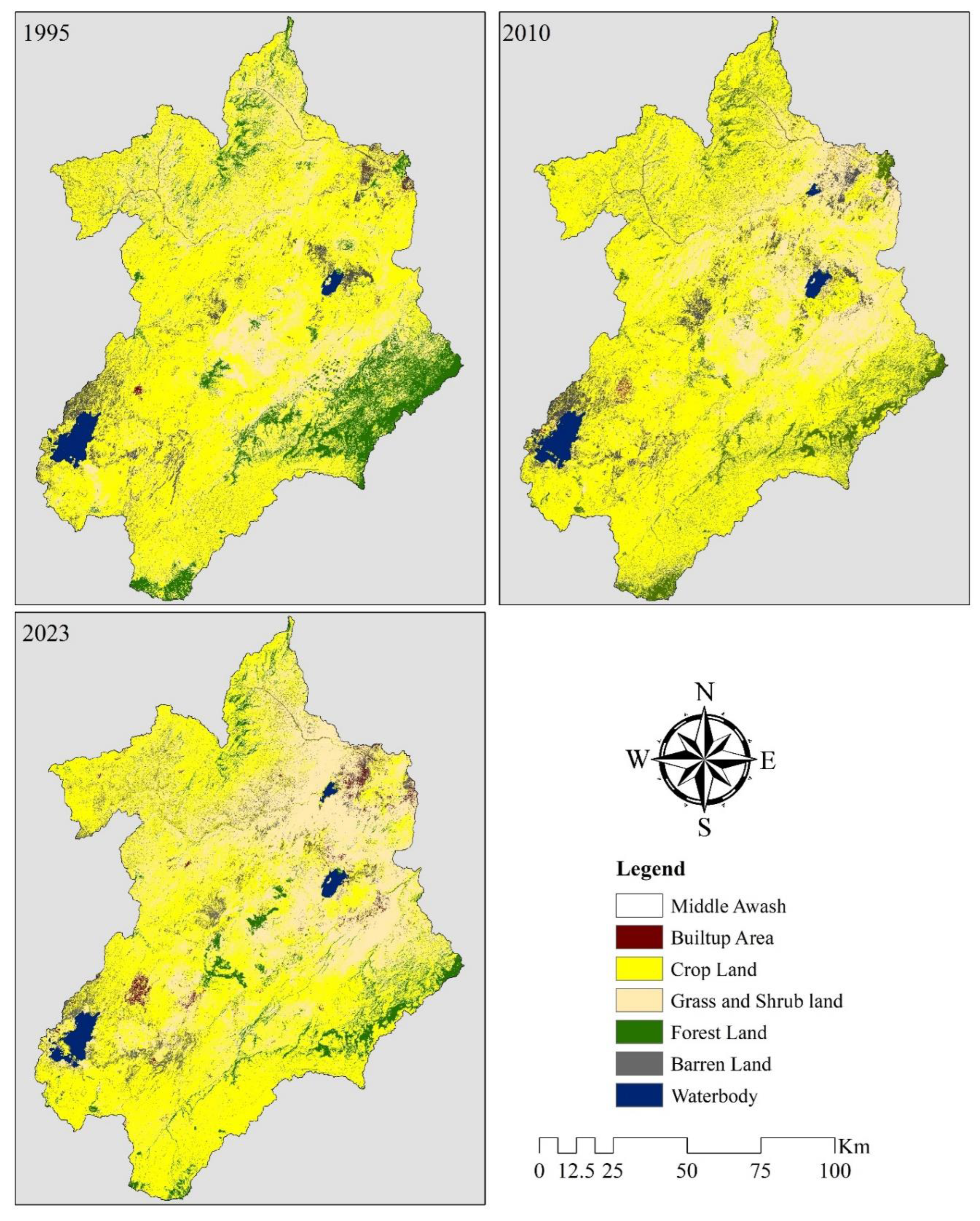
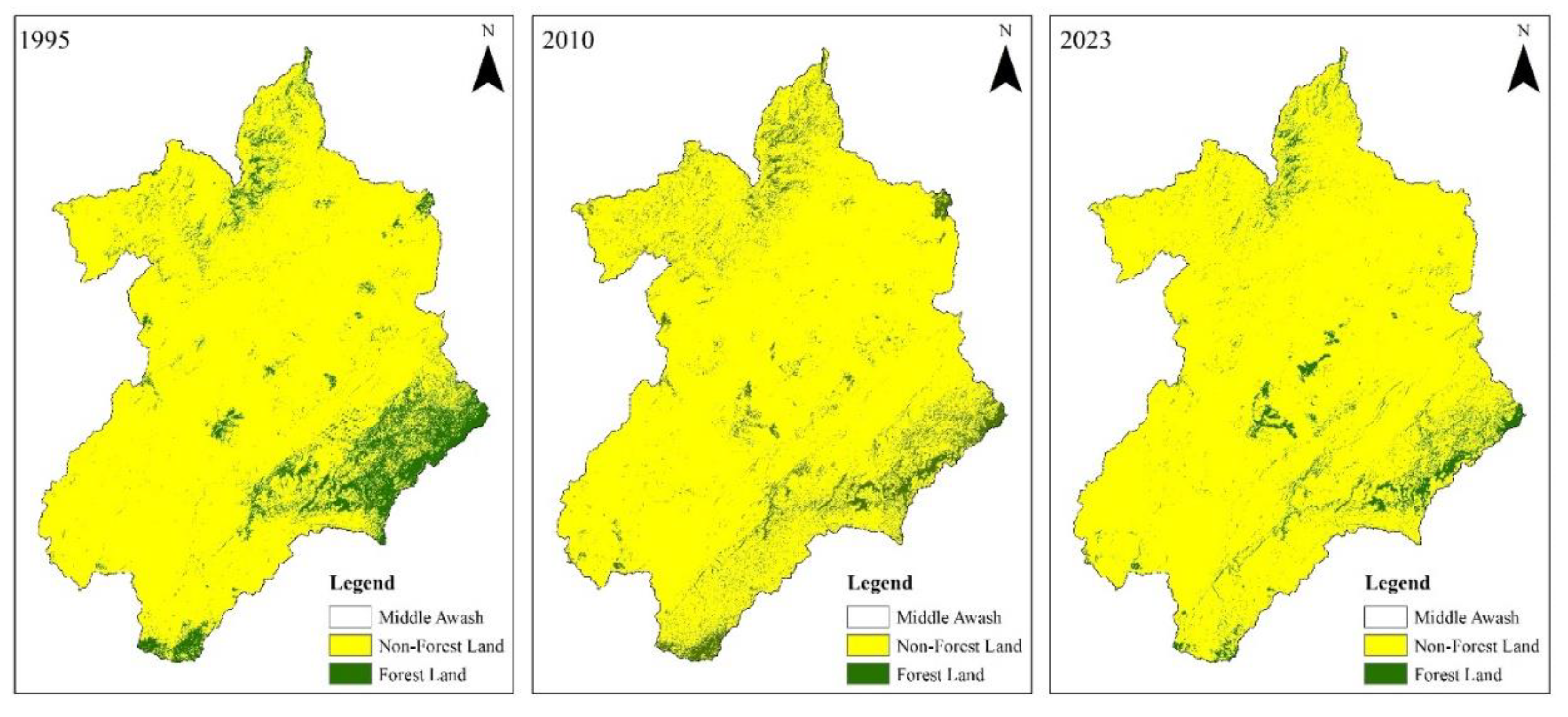
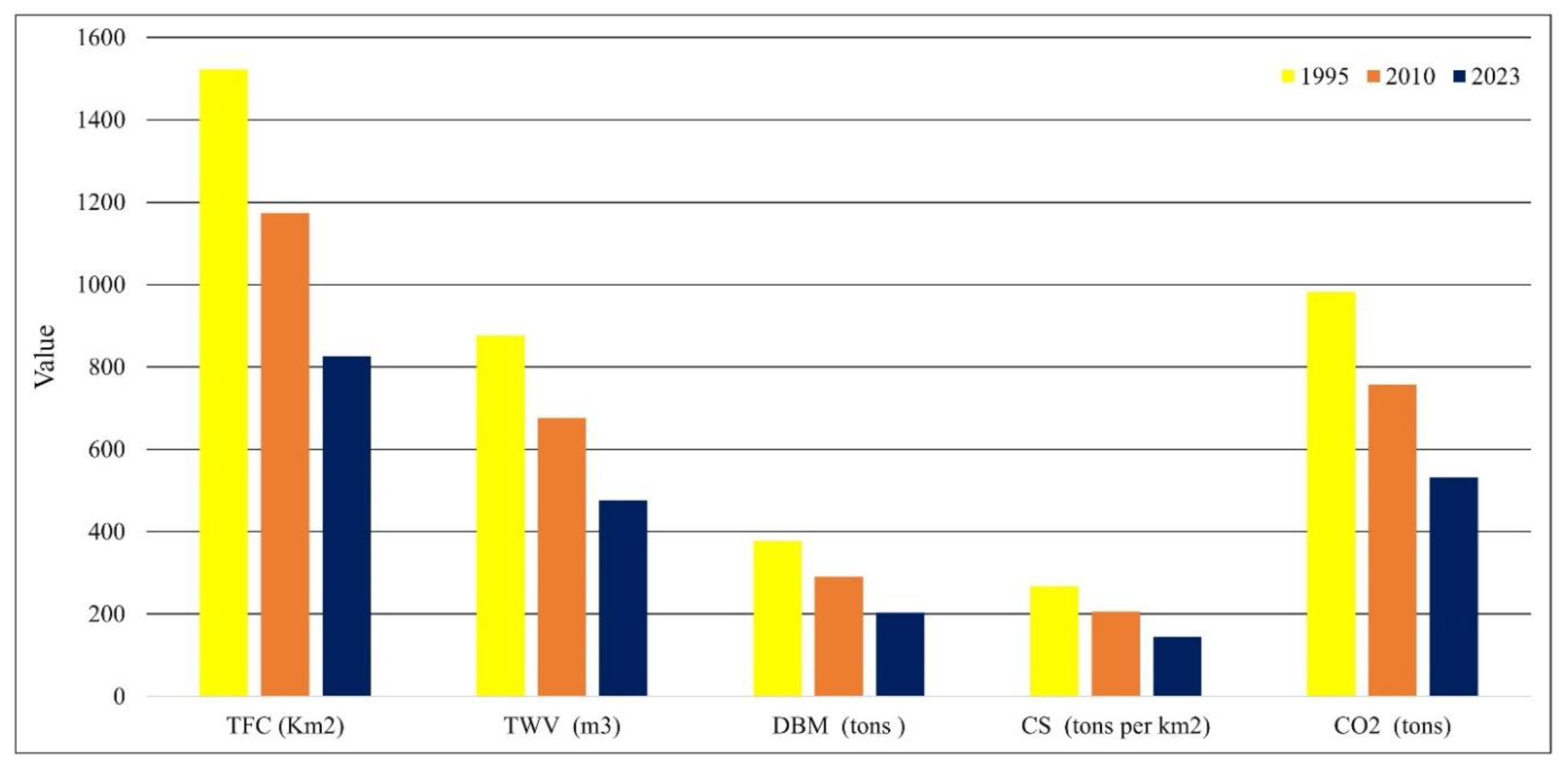
The objective of this study is to investigate the temporal variation of forest cover and carbon stock change within the Middle Awash River Basin in Ethiopia, focusing on the years 1995, 2010, and 2023. The study utilized multi-temporal Landsat imagery and Google Earth Engine cloud API platform and employed the Random Forest Algorithm for LULC classification. The above-ground carbon stock in the present study was computed from total forest cover of the basin. The results indicate a significant decline in forest cover within the Basin, which decreased from 1,521.88 km² in 1995 to 1,174.10 km² in 2010 and further to 825.20 km² by 2023. Alongside this reduction, total wood volume and dry matter biomass also experienced declines, with wood volume falling from 876.28 m³ to 676.03 m³, and then to 475.14 m³, while dry matter biomass decreased from 376.80 tons to 290.69 tons, and finally to 204.31 tons. These trends highlight a troubling reduction in carbon stock and an increase in carbon dioxide emissions. Overall, the gradual decline in carbon stocks and the loss of forest cover within the basin highlight the urgent need to implement effective conservation strategies aimed at restoring and safeguarding the remaining forest ecosystems.
Keywords:
Highlights
- Evaluating forest cover and carbon stock variability is crucial for developing climate change resilience strategies.
- Satellite images are fundamental tools for assessing forest cover and carbon stock dynamics.
- The Middle Awash River basin has experienced significant variations in forest cover and carbon stock.
- It is essential to consider forest regeneration practices to mitigate the resulting climate change crisis.
1. Introduction
2. Methods and Materials
2.1. Study Area
2.2. Data Used
2.3. LULC Derivation
2.4. Accuracy Assessment
2.5. LULC Change Detection
2.6. Carbon Stock Quantification
3. Results and Discussions
3.1. Training Data for Landsat Image Classification
3.2. Accuracy Assessment
3.3. LULC Dynamics Assessment
3.3.1. Forest Cover Dynamics
3.4. Carbon Stock Dynamics
3.5. Result Comparison
3.6. Implication for Climate Change Resilience
3.7. Limitations of the Study and Recommendations for Future Research
4. Conclusion and Recommendations
Funding
Declaration of competing interest
Availability of data and materials
References
- Ahammad, R., Stacey, N., Eddy, I. M. S., Tomscha, S. A., & Sunderland, T. C. H. (2019). Recent trends of forest cover change and ecosystem services in eastern upland region of Bangladesh. Science of the Total Environment, 647, 379–389. [CrossRef]
- Ali, S. (2017). Forest cover change and carbon stock assessment in Swat valley using remote sensing and geographical information systems. Pure and Applied Biology, 6(3). [CrossRef]
- Bantider, A. (2021). Mapping Aboveground Carbon Stocks and Emissions Induced by Land Use and Land Cover Changes in Ethiopia: A Remote Sensing Approach Working Paper No . 3 MoARD; SLMPCM Recommended Cita ... 3. [CrossRef]
- Braun, G., Hellwig, M. K., & Byrnes, W. M. (2007). Global Climate Change and Catholic Responsibility. Journal of Catholic Social Thought, 4(2), 373–401. [CrossRef]
- Case, F. A., & Baylie, M. M. (2022). Decision Analysis of the Adaptation of Households to Extreme Floods Using an Extended Protection Motivation.
- Congalton, R. G., & Green, K. (2008). Assessing the accuracy of remotely sensed data: Principles and practices, second edition. In Assessing the Accuracy of Remotely Sensed Data: Principles and Practices, Second Edition.
- David, B. (2015). Global Warming and Global Change: Facts and Myths. International Journal of Earth Science and Geophysics, 1(1), 1–5. [CrossRef]
- Debebe, B., Senbeta, F., Teferi, E., Diriba, D., & Teketay, D. (2023). Analysis of Forest Cover Change and Its Drivers in Biodiversity Hotspot Areas of the Semien Mountains National Park , Northwest Ethiopia. 1–22.
- Deribew, K. T., & Dalacho, D. W. (2019). Land use and forest cover dynamics in the North - eastern Addis Ababa , central highlands of Ethiopia. Environmental Systems Research, 1–18. [CrossRef]
- Dibaba, W. T. (2023). Urbanization-induced land use/land cover change and its impact on surface temperature and heat fluxes over two major cities in Western Ethiopia. Environmental Monitoring and Assessment, 195(9), 1–20. [CrossRef]
- Goheer, M. A., Fatima, L., Farah, H., Hassan, S. S., & Abbas, N. (2023). Assessment of change in forests land, carbon stock and carbon emissions of KPK, Pakistan for past three decades using geospatial techniques. Journal of Water and Climate Change, 14(2), 442–453. [CrossRef]
- Goheer, M. A., Hassan, S. S., Gul, K., Waqar, M., & Parveen, N. (2022). GIS-based spatio-temporal assessment of forest cover change and carbon sequestrations of District Abbottabad, Pakistan. Journal of Water and Climate Change, 13(8), 2962–2971. [CrossRef]
- Habib, S., & Al-Ghamdi, S. G. (2021). Estimation of Above-Ground Carbon-Stocks for Urban Greeneries in Arid Areas: Case Study for Doha and FIFA World Cup Qatar 2022. Frontiers in Environmental Science, 9(June 2021), 1–17. [CrossRef]
- Kassaye, M., Derebe, Y., Kibrie, W., Debebe, F., Emiru, E., Gedamu, B., & Tamir, M. (2024). The effects of environmental variability and forest management on natural forest carbon stock in northwestern Ethiopia. Ecology and Evolution, 14(6), 1–19. [CrossRef]
- Khan, I. A., Khan, W. R., Ali, A., & Nazre, M. (2021). Assessment of above-ground biomass in pakistan forest ecosystem’s carbon pool: A review. Forests, 12(5), 1–18. [CrossRef]
- Khan, S. A., Gulfishan, M., Mir, R. A., & Andrabi, S. A. H. (2022). Forest cover change detection through modern applications and its environmental impacts, A review “Constraints and Prospects for Income generation from NWFP Commercialization in Jammu & Kashmir” View project forest conservation View project. 4(July), 75–82. https://www.researchgate.net/publication/362133210.
- Kumar, R., Nandy, S., Agarwal, R., & Kushwaha, S. P. S. (2014). Forest cover dynamics analysis and prediction modeling using logistic regression model Forest cover dynamics analysis and prediction modeling using logistic regression model. Ecological Indicators, 45(June 2018), 444–455. [CrossRef]
- Lawrence, D., Coe, M., Walker, W., Verchot, L., & Vandecar, K. (2022). The Unseen Effects of Deforestation: Biophysical Effects on Climate. Frontiers in Forests and Global Change, 5(March), 1–13. [CrossRef]
- Legesse, F., Degefa, S., & Soromessa, T. (2024). Carbon stock dynamics in a changing land use land cover of the Upper Awash River Basin: Implications for climate change management. Sustainable Environment, 10(1), 1–18. [CrossRef]
- Li, C., Canada, N. R., Liu, S., & Zhang, Y. (2008). Forest Management and Carbon Sink Dynamics: a Study in Boreal and Sub- Alpine Forest Regions. January. [CrossRef]
- Li, J., Ren, J., Ma, X., & Xiao, G. (2023). Environmental efficiency of ports under the dual carbon goals: Taking China’s Bohai-rim ports as an example. Frontiers in Marine Science, 10(April), 1–10. [CrossRef]
- Li, Q., Wei, X., Zhang, M., Liu, W., Fan, H., Zhou, G., Giles-Hansen, K., Liu, S., & Wang, Y. (2017). Forest cover change and water yield in large forested watersheds: A global synthetic assessment. Ecohydrology, 10(4), 1–7. [CrossRef]
- Loukika, K. N., Keesara, V. R., & Sridhar, V. (2021). Analysis of land use and land cover using machine learning algorithms on google earth engine for Munneru river basin, India. Sustainability (Switzerland), 13(24). [CrossRef]
- Mirbach, V. (2000). Carbon budget accounting at the forest management unit level: an overview of issues and methods. July, 13.
- Moisa, M. B., Dejene, I. N., Deribew, K. T., Gurmessa, M. M., & Gemeda, D. O. (2023). Impacts of forest cover change on carbon stock, carbon emission and land surface temperature in Sor watershed, Baro Akobo Basin, Western Ethiopia. Journal of Water and Climate Change, 14(8), 2842–2860. [CrossRef]
- Morris, B. S., Chrysochou, P., Christensen, J. D., Orquin, J. L., Barraza, J., Zak, P. J., & Mitkidis, P. (2019). Stories vs. facts: triggering emotion and action-taking on climate change. Climatic Change, 154(1–2), 19–36. [CrossRef]
- Mukul, S. A., Halim, M. A., & Herbohn, J. (2021). Forest Carbon Stock and Fluxes: Distribution, Biogeochemical Cycles, and Measurement Techniques (pp. 361–376). [CrossRef]
- Munasinghe, M., & Swart, R. (2005). Primer on climate change and sustainable development: Facts, policy analysis, and applications. In Primer on Climate Change and Sustainable Development: Facts, Policy Analysis, and Applications. [CrossRef]
- Nam, K., Lee, W. K., Kim, M., Kwak, D. A., Byun, W. H., Yu, H., Kwak, H., Kwon, T., Sung, J., Chung, D. J., & Lee, S. H. (2015). Spatio-temporal change in forest cover and carbon storage considering actual and potential forest cover in South Korea. Science China Life Sciences, 58(7), 713–723. [CrossRef]
- Negassa, M. D., Mallie, D. T., & Gemeda, D. O. (2020). Forest cover change detection Forest cover change detection using Geographic Information Systems and remote sensing techniques: a spatio-temporal study on Komto Protected forest priority area, East Wollega Zone, Ethiopia. Environmental Systems Research, 1–14. [CrossRef]
- Othow, O. O., Legesse Gebre, S., & Obsi Gemeda, D. (2017). Analyzing the Rate of Land Use and Land Cover Change and Determining the Causes of Forest Cover Change in Gog District, Gambella Regional State, Ethiopia. Journal of Remote Sensing & GIS, 06(04). [CrossRef]
- Pan, Y., Birdsey, R. A., Phillips, O. L., Houghton, R. A., Fang, J., Kauppi, P. E., Keith, H., Kurz, W. A., Ito, A., Lewis, S. L., Nabuurs, G. J., Shvidenko, A., Hashimoto, S., Lerink, B., Schepaschenko, D., Castanho, A., & Murdiyarso, D. (2024). The enduring world forest carbon sink. Nature, 631(8021), 563–569. [CrossRef]
- Pandey, V. K., & Mishra, A. (2015). Facts and trend of Climate Change - with reference to Geological time frame. International Journal of Current Research in Science and Technology, 1(3), 43–60.
- Pechanec, V., Štěrbová, L., Purkyt, J., Prokopová, M., Včeláková, R., Cudlín, O., Vyvlečka, P., Cienciala, E., & Cudlín, P. (2022). Selected Aspects of Carbon Stock Assessment in Aboveground Biomass. Land, 11(1), 1–16. [CrossRef]
- Phan, T. N., Kuch, V., & Lehnert, L. W. (2020). Land cover classification using google earth engine and random forest classifier-the role of image composition. Remote Sensing, 12(15). [CrossRef]
- Prevedello, J. A., Winck, G. R., Weber, M. M., Nichols, E., & Sinervo, B. (2019). Impacts of forestation and deforestation on local temperature across the globe. PLoS ONE, 14(3), 1–18. [CrossRef]
- Rahayu, S., Lusiana, B., & van Noordwijk, M. (2005). Above ground carbon stock assessment for various land use systems in Nunukan, East Kalimantan. Carbon Stock Monitoring in Nunukan, East Kalimantan: A Spatial and Modelling Approach. World Agroforestry Centre, SE Asia, Bogor, Indonesia, 21–34.
- Regassa, B., Kassaw, M., & Bagyaraj, M. (2020). Analysis of Urban Expansion and Modeling of LULC Changes Using Geospatial Techniques: The Case of Adama City. Remote Sensing of Land, 4(1–2), 40–58. [CrossRef]
- Report, G. D. O. A. (2022). Drought in East Africa August 2022. August. [CrossRef]
- Solomon, & Moon, H. (2018). Expansion of Exotic Tree Species and Impacts on Management of the Indigenous Trees; Emphasis on Eucalyptus Species in Wolaita, South Ethiopia-A. Communities, 19, 20.
- Solomon, N., Annang, T., Hishe, H., Pabi, O., Asante, I. K., & Birhane, E. (2018). Forest cover change, key drivers and community perception in Wujig Mahgo Waren forest of northern Ethiopia. Land, 7(1). [CrossRef]
- Sun, W., Shan, J., Wang, Z., Wang, L., Lu, D., Jin, Z., & Yu, K. (2020). Geospatial Analysis of Urban Expansion Using Remote Sensing Methods and Data: A Case Study of Yangtze River Delta, China. Complexity, 2020. [CrossRef]
- Tadese, S., Soromessa, T., Aneseye, A. B., & Gebeyehu, G. (2023). The impact of land cover change on the carbon stock of moist afromontane forests in the Majang Forest Biosphere Reserve. Carbon Balance and Management, 1–20. [CrossRef]
- Tikuye, B. G., Rusnak, M., Manjunatha, B. R., & Jose, J. (2023). Land Use and Land Cover Change Detection Using the Random Forest Approach: The Case of The Upper Blue Nile River Basin, Ethiopia. Global Challenges, 7(10), 1–11. [CrossRef]
- Tola, F. K. (2023). Drivers of Forest cover changes in and around Jorgo Wato Forest, West Wallagga, Oromia, Ethiopia. Heliyon, 9(8), e19053. [CrossRef]
- Tran, P., Marincioni, F., & Shaw, R. (2010). Catastrophic flood and forest cover change in the Huong river basin, central Viet Nam: A gap between common perceptions and facts. Journal of Environmental Management, 91(11), 2186–2200. [CrossRef]
- Wlodarczyk, J., Bielen, M., & Gibas, P. (2022). Trying to See the Forest for the Trees: Forest Cover and Economic Activity in Africa.
- Xiao, H., Liu, J., He, G., Zhang, X., Wang, H., Long, T., Zhang, Z., Wang, W., Yin, R., Guo, Y., Cheng, B., & Cao, Q. (2022). Data-Driven Forest Cover Change and Its Driving Factors Analysis in Africa. Frontiers in Environmental Science, 9(January), 1–13. [CrossRef]
- Yalew, A. W., Hirte, G., Lotze-Campen, H., & Tscharaktschiew, S. (2018). Climate change, agriculture, and economic development in Ethiopia. Sustainability (Switzerland), 10(10). [CrossRef]
- Yesuph, A. Y., & Dagnew, A. B. (2019). Land use/cover spatiotemporal dynamics, driving forces and implications at the Beshillo catchment of the Blue Nile Basin, North Eastern Highlands of Ethiopia. Environmental Systems Research, 8(1). [CrossRef]
- You, G. J., & Ringler, C. (2013). Hydro-economic modeling of climate change impacts in Ethiopia IFPRI Discussion Paper 00960 Hydro-Economic Modeling of Climate Change Impacts in Ethiopia Gene Jiing-Yun You Environment and Production Technology Division. January 2010.

| Satellite Data | Purpose | Resolution | Year | Source |
|---|---|---|---|---|
| Landsat 5 TM | LULC derivation | 30m 30m | 1995 | USGS |
| Landsat 7 ETM+ | LULC derivation | 30m 30m | 2010 | USGS |
| Landsat 8 OLI | LULC derivation | 30m 30m | 2023 | USGS |
| Cover point data | LULC validation | Point data | 1995, 2010, and 2023 | Google Earth Pro |
| LULC Classes | Description |
|---|---|
| Forest land | Places that have a high concentration of trees, such as deciduous, mixed, and evergreen forests, native tree species plantations were also taken into consideration. |
| Bare land | Open fields with, little to without trees, beached, dunes, grass, sparsely vegetated areas, and bare gravel. |
| Waterbodies | Covered by water like rivers, lakes, reservoirs, and others |
| Grass and shrubland | Grass, range, shrubs, and bushes. |
| Agricultural land | Permanent crops. |
| Built-up area | Residential, commercial units and industries, roads, and other related property |
| Land cover classes | Number of training data | ||
|---|---|---|---|
| 1995 | 2010 | 2023 | |
| Built up area | 779 | 844 | 1191 |
| Waterbody | 325 | 355 | 365 |
| Agricultural land | 1649 | 1677 | 1789 |
| Forrest land | 2361 | 2347 | 2451 |
| Barren land | 686 | 785 | 765 |
| Grass and shrub land | 1464 | 1451 | 1342 |
| Measurement indices | Year | ||
|---|---|---|---|
| 1995 | 2010 | 2023 | |
| Overall accuracy | 81.5% | 85.1% | 88% |
| Kappa | 0.81 | 0.83 | 0.87 |
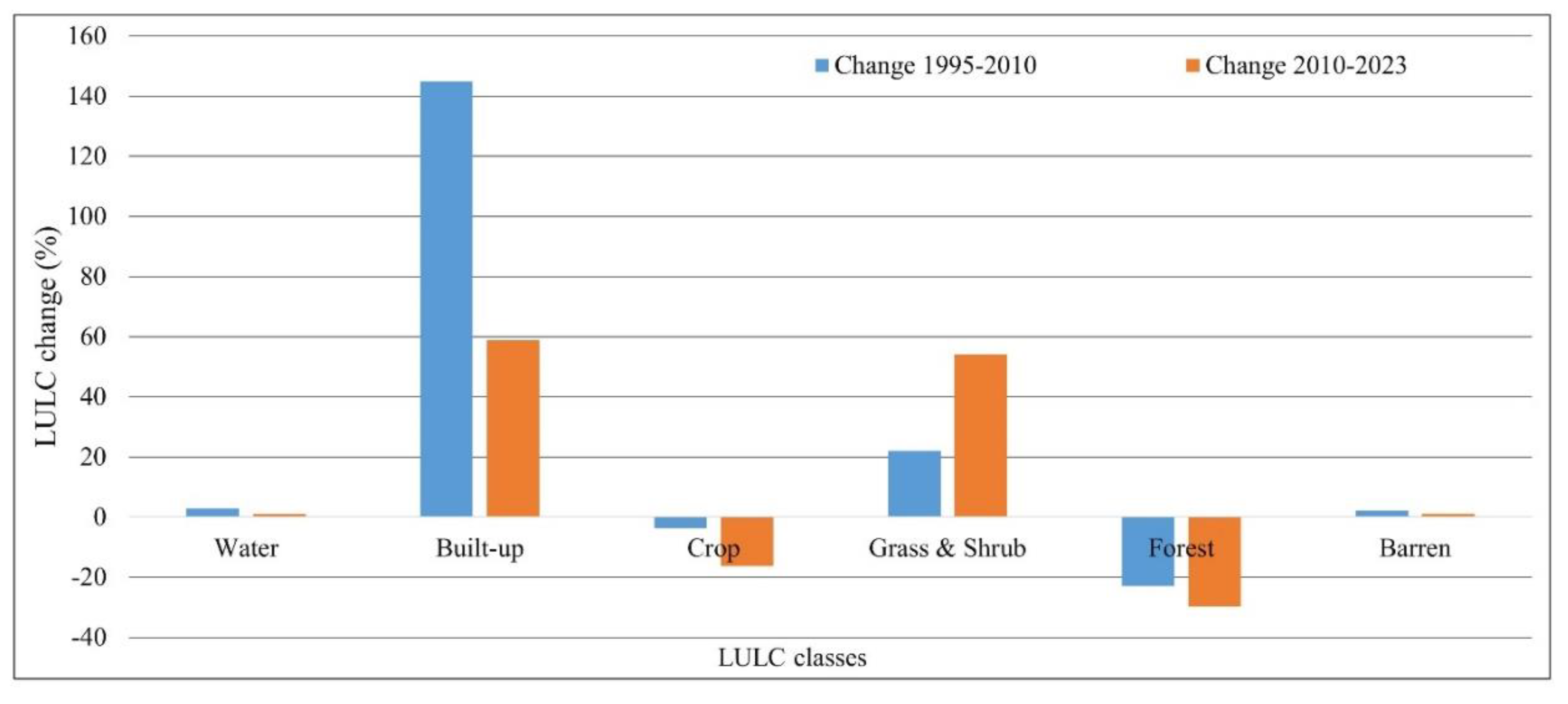
| LULC class | 1995 | 2010 | 2023 | Change | ||||
|---|---|---|---|---|---|---|---|---|
| Area (Km2) | % | Area (Km2) | % | Area (Km2) | % | 1995-2010 | 2010-2023 | |
| Water | 198.19 | 1.28 | 203.97 | 1.32 | 206.09 | 1.33 | 2.92 | 1.04 |
| Built-up | 39.50 | 0.26 | 96.76 | 0.63 | 153.67 | 0.99 | 144.96 | 58.82 |
| Crop | 10155.70 | 65.60 | 9796.42 | 63.28 | 8202.61 | 52.99 | -3.54 | -16.27 |
| Grass & Shrub | 2839.30 | 18.34 | 3467.20 | 22.40 | 5341.56 | 34.51 | 22.11 | 54.06 |
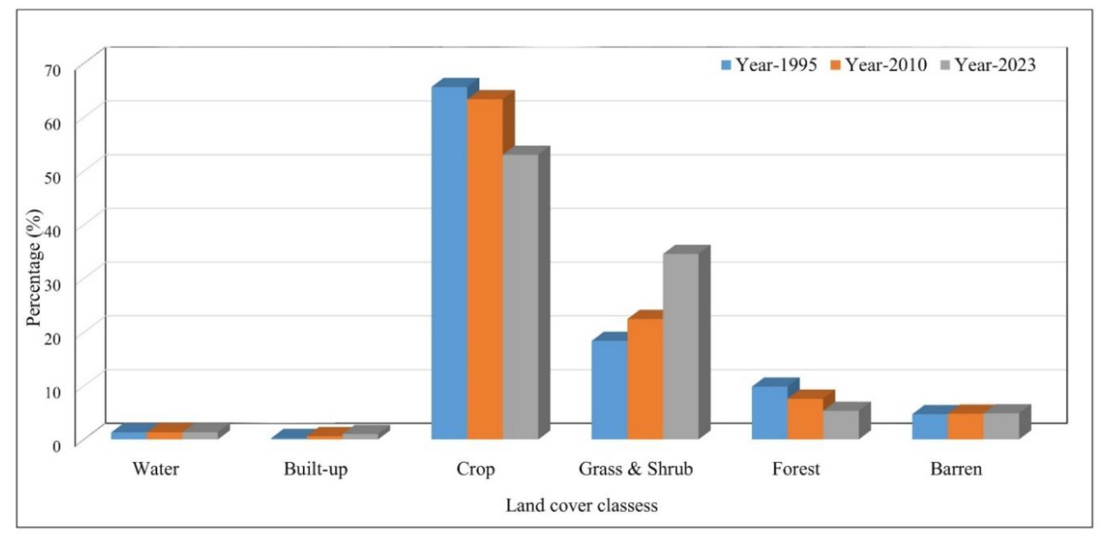
| Forest | 1521.88 | 9.83 | 1174.10 | 7.58 | 825.20 | 5.33 | -22.85 | -29.72 |
| Barren | 725.71 | 4.69 | 741.84 | 4.79 | 751.14 | 4.85 | 2.22 | 1.25 |
| Total | 15480.28 | 100.00 | 15480.28 | 100.00 | 15480.28 | 100.00 | 0.00 | 0.00 |
| Biomass and carbon stock | 1995 | 2010 | 2023 |
|---|---|---|---|
| TFC (km2) | 1521.8847 | 1174.1 | 825.2037 |
| TWV (m3) | 876.27686 | 676.0282 | 475.139087 |
| DBM (tons ) | 376.79905 | 290.6921 | 204.309807 |
| CS (tons per km2) | 267.702581 | 206.5266 | 145.154991 |
| CO2 (tons) | 981.585053 | 757.2712 | 532.239806 |
Disclaimer/Publisher’s Note: The statements, opinions and data contained in all publications are solely those of the individual author(s) and contributor(s) and not of MDPI and/or the editor(s). MDPI and/or the editor(s) disclaim responsibility for any injury to people or property resulting from any ideas, methods, instructions or products referred to in the content. |
© 2024 by the authors. Licensee MDPI, Basel, Switzerland. This article is an open access article distributed under the terms and conditions of the Creative Commons Attribution (CC BY) license (http://creativecommons.org/licenses/by/4.0/).