Introduction
Bhutan has made a commitment to maintain its forest coverage at a minimum of 60% in perpetuity. Natural resources are the true wealth of a nation therefore, sustainable management, accounting, and usage is fundamental. However, with rapid developmental activities, the demand for resources is also growing. With accelerated infrastructure constructions, the timber demand has increased both in rural as well as in urban areas (Palden, 2018). The Department of Forest and Park Services (DoFPS) has carried out Forest Resource Potential Assessment (FRPA) in the years 2004 and 2013 to determine the extent of forests that can be brought under sustainable forest management. Furthermore, the assessment provides a detailed account of the growing stock of the forest with Potential Forest Production Area (DoFPS, 2013). Determination of Potential Forest Production Area (PFPA) plays a very important role in sustainable forest management as it provides information on the potential forest areas that can be brought under sustainable harvesting. This project is carried out with the following objectives:
To assess the Potential Forest Production Area (PFPA) of Wangdue Phodrang.
To compare the results of Forest Resource Potential Assessment, 2013 and present of Wangdue Phodrang.
Methodology
A total of 8 spatial criteria are derived with reference to various Acts, Regulations, and Policies pertaining forest management in Bhutan (DoFPS, 2013). These criteria are applied to identify the Potential Forest Production Area (PFPA) of Wangdue Phodrang. The same criteria were applied in Forest Resource Potential Assessment (FRPA) 2013. The criteria include:
Not within 200m both sides of roads.
Not within 30m form major drainages.
Not within 1km from rural settlements.
Not within 1.5km from urban areas.
Not within RAMSAR wetland sites.
Not within existing botanical and recreational parks.
Not within existing Forest Management Units (FMU).
Not within existing Community Forests (CF).
Furthermore, spatial multi-criteria of slopes were carried out to segregate operable slopes which includes:
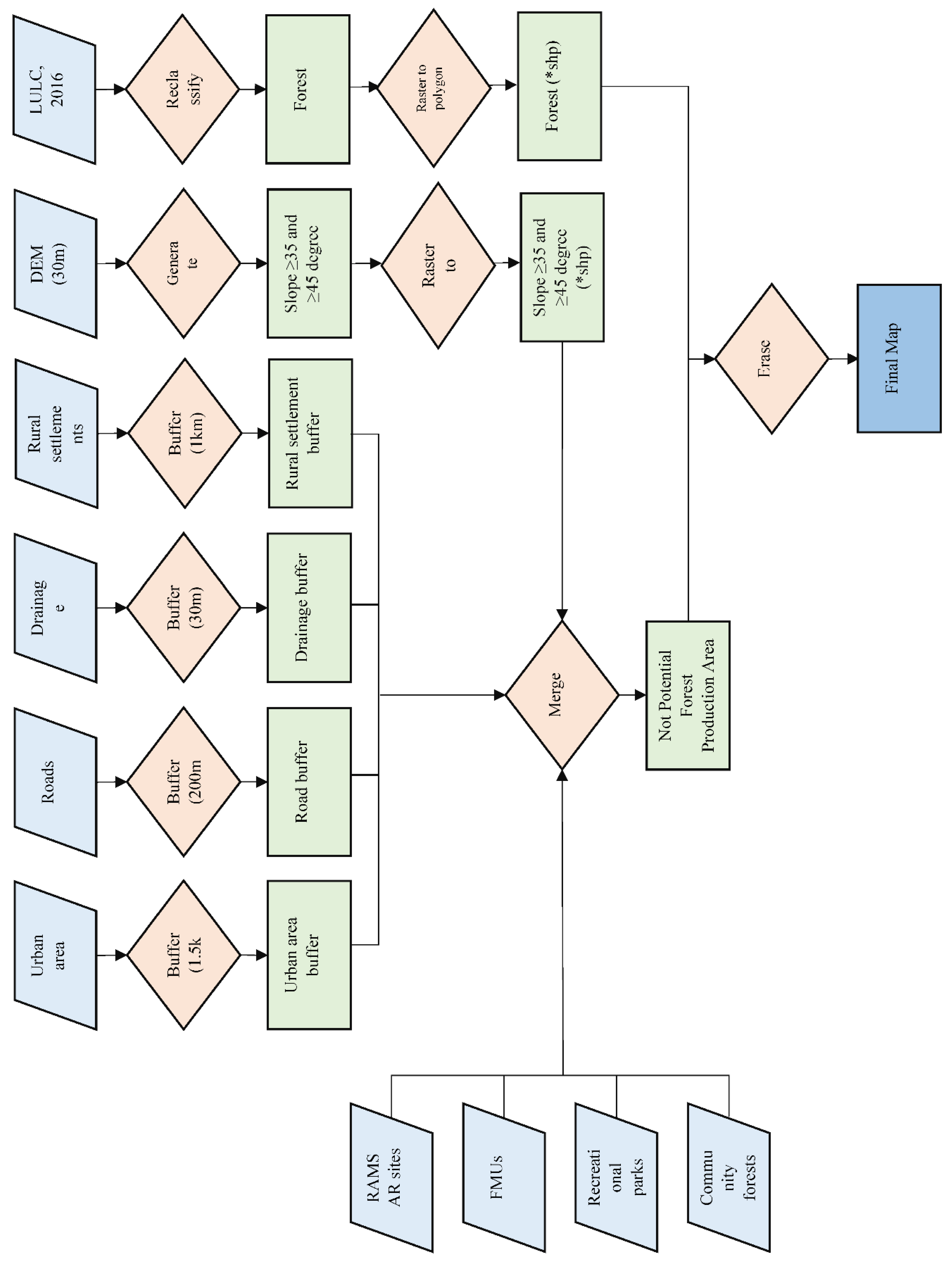
It is to be noted that all the above-mentioned criteria are formulated by the Department of Forest and Park Services. Secondary data including roads, drainage, urban and rural settlements, Forest Management Units, and Community Forests were prearranged by ma’am Deki Wangmo. Primary data including RAMSAR wetland sites and recreational parks were delineated using Google image. The flow chart below represents the spatial analysis carried out to generate Potential Forest Production Area (PFPA) of Wangdue Phodrang.
Figure 1.
Flow chart illustrating the methodology in identifying potential forest production area.
Figure 1.
Flow chart illustrating the methodology in identifying potential forest production area.
Results
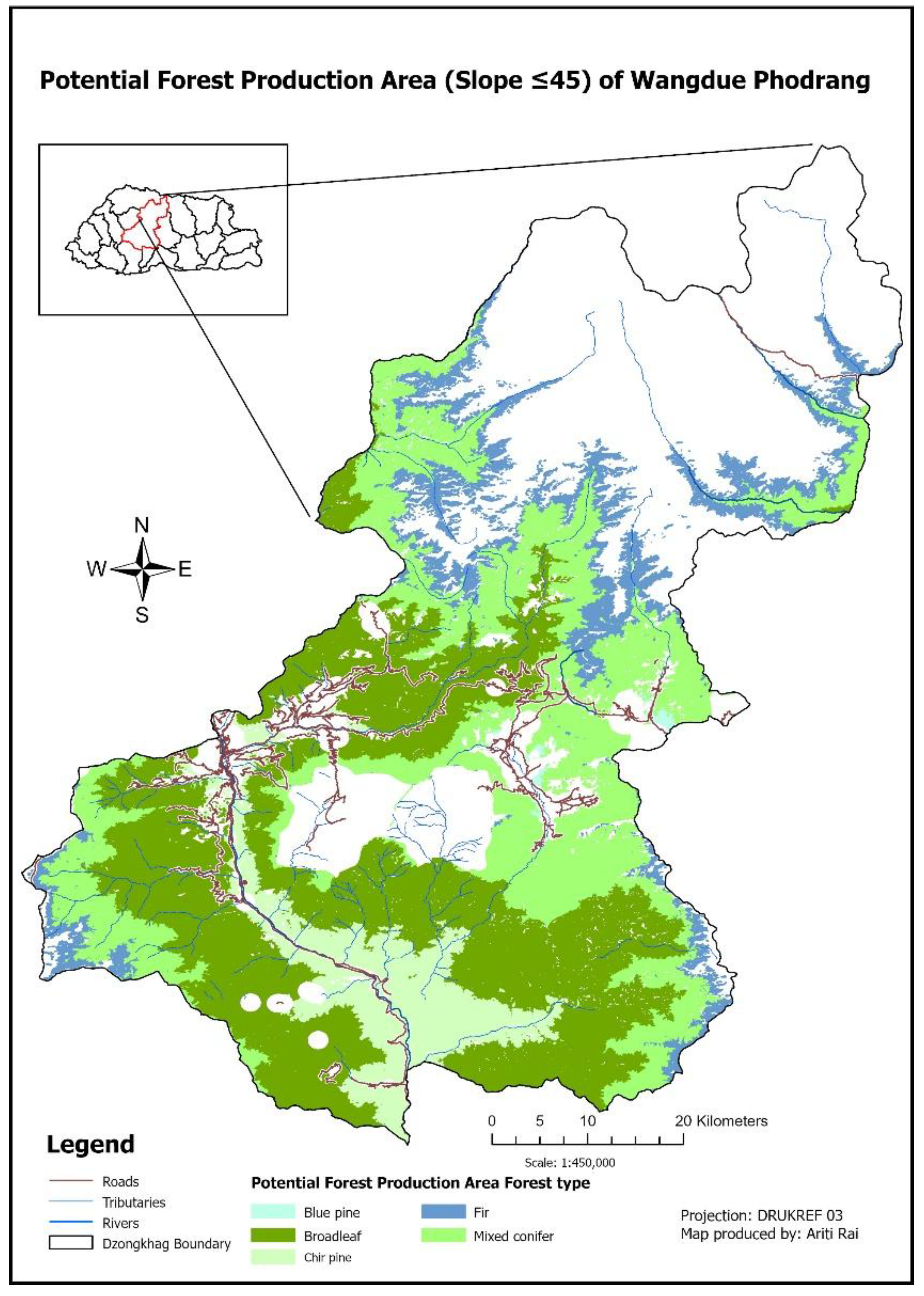
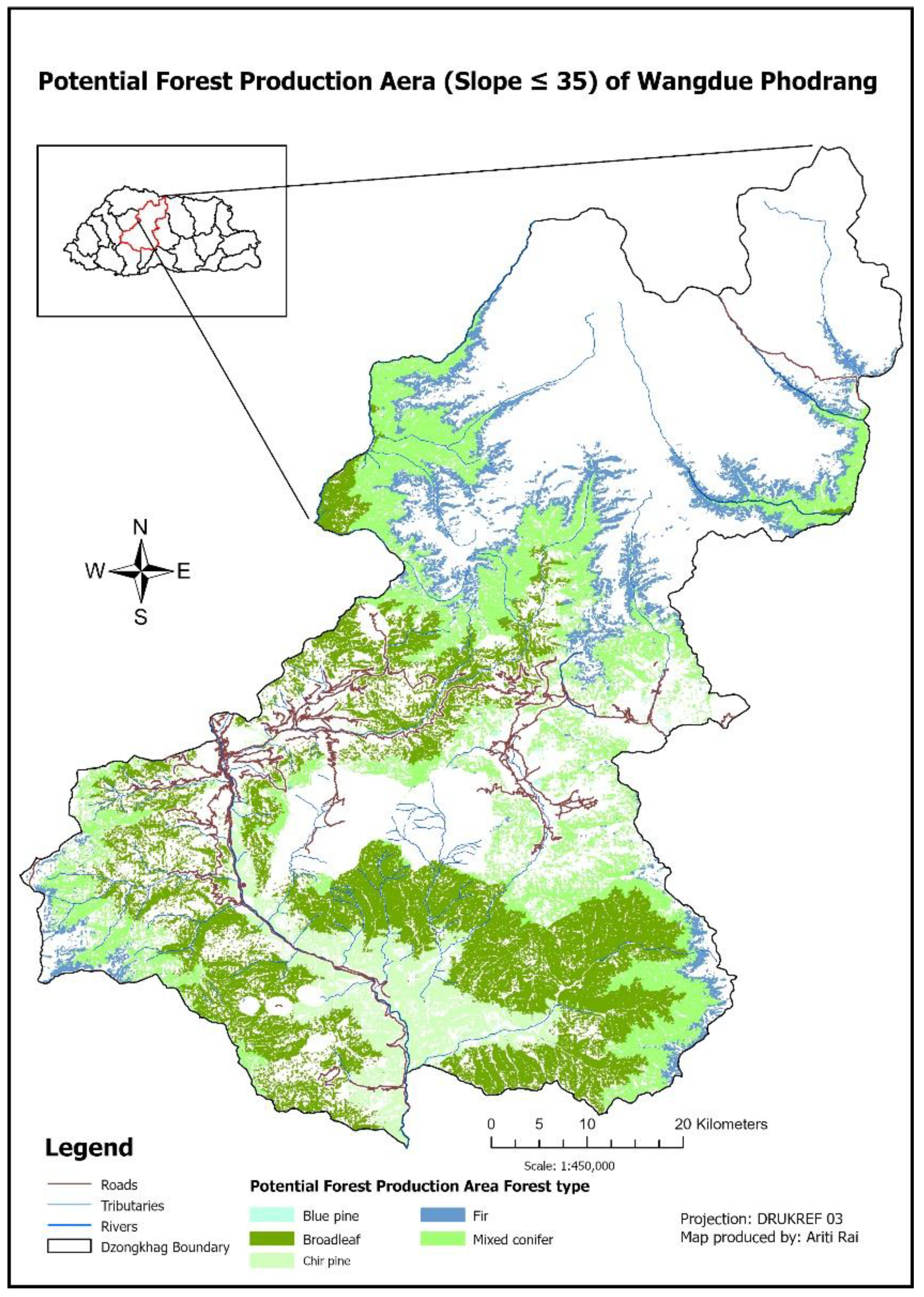
The results of the spatial analysis are presented below. The first map (
Figure 2) represents the Potential Forest Production Area in slope less than or equal to 45 degree. The second map (
Figure 3) represents the Potential Forest Production Area in slope less than or equal to 35 degree.
Based on slope less than or equal to 45 degree, a total of 205779.9 hectare of forest land is under Potential Forest Production Area (PFPA). Details of the potential area is illustrated in the following table.
Table 1.
Potential Forest Production Area by Forest type (Slope ≤ 45).
Table 1.
Potential Forest Production Area by Forest type (Slope ≤ 45).
| Dzongkhag |
Forest Type |
Area (ha) |
| Wangdue Phodrang |
Blue pine |
652.2 |
| Broadleaf |
89864.8 |
| Chir pine |
20926.2 |
| Fir |
24784.0 |
| Mixed conifer |
69552.7 |
| Total |
205779.9 |
Based on slope less than or equal to 35 degree, a total of 84618.3 hectare of forest land is under Potential Forest Production Area (PFPA). Details of the potential area is illustrated in the following table.
Table 2.
Potential Forest Production Area by Forest type (Slope ≤ 35).
Table 2.
Potential Forest Production Area by Forest type (Slope ≤ 35).
| Dzongkhag |
Forest Type |
Area (ha) |
| Wangdue Phodrang |
Blue pine |
76.8 |
| Broadleaf |
37326.0 |
| Chir pine |
8811.5 |
| Fir |
10999.4 |
| Mixed conifer |
27404.6 |
| Total |
84618.3 |
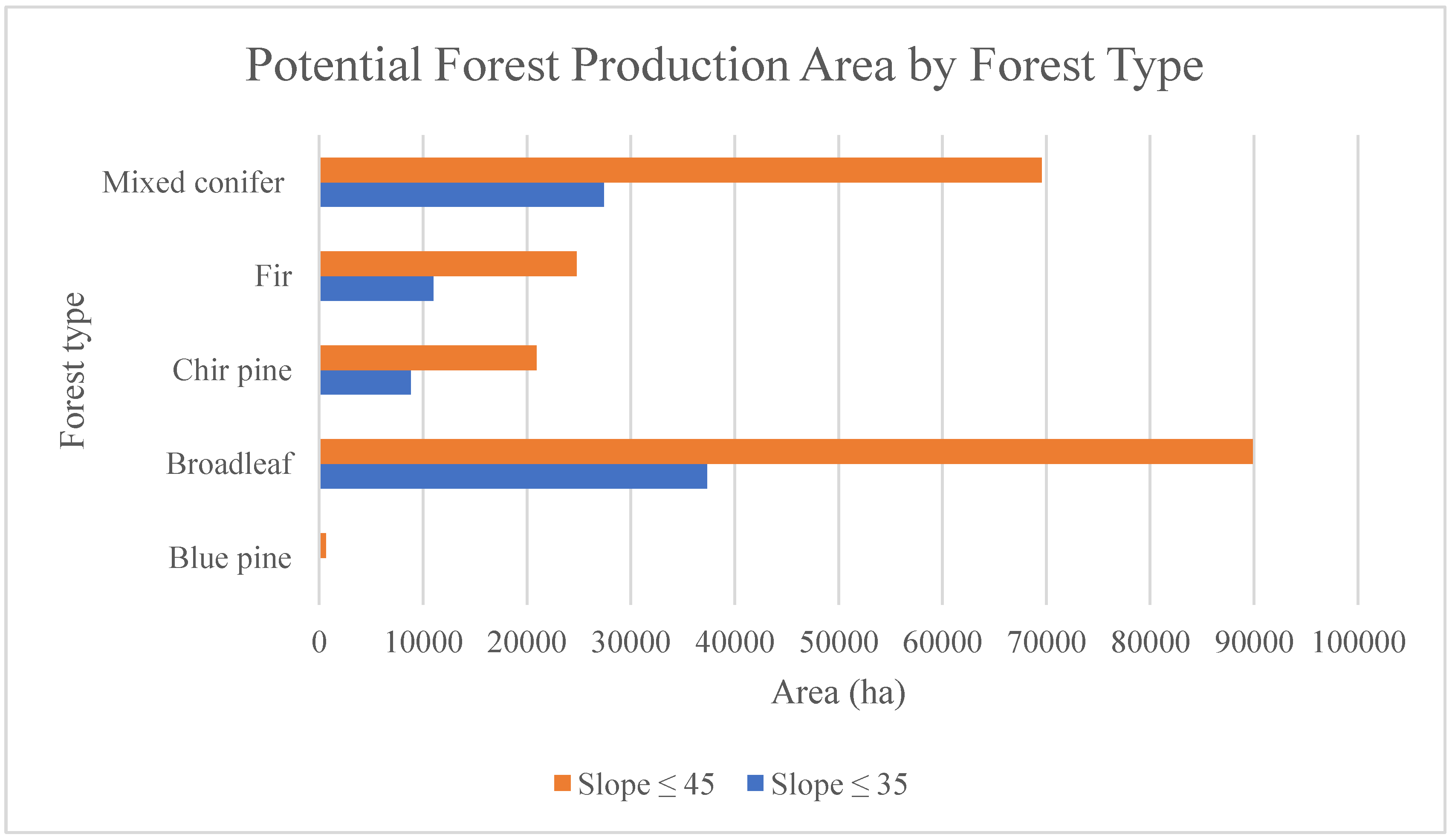
The graph below compares the potential forest production area of each forest types with slope less than or equal to 45 degree and with slope less than or equal to 35 degree.
Figure 4.
Graph illustrating Potential Forest Production Area in slope ≤ 45 and slope ≤ 35.
Figure 4.
Graph illustrating Potential Forest Production Area in slope ≤ 45 and slope ≤ 35.
The 10-degree difference between slope less than or equal to 35 and 45 degree, the Potential Forest Production Area is reduced to an estimated half. Additionally, the production potential of blue pine is minimum and the production potential of broadleaf is maximum.
Discussions
Wangdue Phodrang has a large forested area making the Dzongkhag rich in biodiversity and natural resources. The understanding of and accounting for its Potential Forest Production Area is crucial for sustainably managing its natural resources. Out of 266620 ha of forested land, 205779 ha of forested land can be used for sustainable timber harvesting within the slope of 45 degree and below which accounts for 77% of the total forested area. Additionally, 84618 ha of forested land can be used for sustainable timber harvesting within the slope of 35 degree and below which accounts for 18% of the forested area. Though the production potential within the slope of 45 degree is more, it would be a wise and sustainable choice to choose production within the slope of 35 degree. A Potential Forest Production Area of 18% of the total forest area will ensure both timber supply and forest coverage.
The official report of 2013 by DoFPS has the following results on the Potential Forest Production Area with slope less than or equal to 35 degree of Wangdue Phodrang:
Table 3.
Potential Forest Production Area of Wangdue Phodrang, 2013 (slope ≤ 35).
Table 3.
Potential Forest Production Area of Wangdue Phodrang, 2013 (slope ≤ 35).
| Dzongkhag |
Forest type |
Area (ha) |
| Wangdue Phodrang |
Broadleaf |
24541.8 |
| Chir pine |
1297.3 |
| Mixed conifer |
4600.6 |
| Total |
30439.7 |
The production potential within 35-degree slope has decreased by 3035.1 ha or by 9.9%. this indicates the decline in forest resources especially timber. Various reasons including illegal timber harvesting, ineffective forest regulations, and corruption among officials could be the cause (Wangdi, 2022).
This report on Potential Forest Production Area of Wangdue Phodrang is generated using LULC 2016 whereas the official report on Potential Forest Production Area by DoFPS was generated using LULC 2010. Therefore, this report is advantageous since LULC 2016 has detailed classifications of land-use land-cover compared to LULC 2010. However, this report is only an imitation of the original work for education purposes. Further, this report cannot be considered valid since it was not supervised and reviewed. A proper and supervised report on Forest Resource Potential Assessment (FRPA) should be done in order to have an in-depth and updated knowledge of Forest Resource Potential Assessment (FRPA) in Bhutan. Students might also take the initiative with proper supervision, sufficient time, and resources.
Conclusions
To sum up, this project mainly aims to study the Potential Forest Production Area of Wangdue Phodrang which has a large area of forest cover. Through spatial analysis, Wangdue Phodrang has a considerable forested land for production area. However, the Potential Forest Production Area within 35-degree slope has decreased due to various reasons. To achieve the goal of maintaining 60% forest cover at all times to come, we must keep an account of our forest resources and manage it sustainably. Thus, the assessment of Forest Resource Potential Assessment (FRPA) and within the assessment, the determination of Potential Forest Production Area (PFPA) is very important.
|
Disclaimer/Publisher’s Note: The statements, opinions and data contained in all publications are solely those of the individual author(s) and contributor(s) and not of MDPI and/or the editor(s). MDPI and/or the editor(s) disclaim responsibility for any injury to people or property resulting from any ideas, methods, instructions or products referred to in the content. |
© 2024 by the authors. Licensee MDPI, Basel, Switzerland. This article is an open access article distributed under the terms and conditions of the Creative Commons Attribution (CC BY) license (http://creativecommons.org/licenses/by/4.0/).