
Submitted:
29 October 2024
Posted:
29 October 2024
You are already at the latest version
Abstract
Accidents involving heavy road vehicles are often destructive, causing operational losses, human casualties, infrastructure losses, and negative environmental impacts. The risk is especially high in wintertime traffic. Eureka Xecs SafeTrucks-project (Heavy traffic safety improvements by advanced dynamics and road weather services) develops real-time vehicle-specific weather and safety services tailored to each vehicle, based on the vehicle’s own sensor observations combined with data from the service systems and an analysis of the vehicle's own dynamics. The services are also analyzed by Digital Twin modelling, in order evaluate and refine them in a controlled environment. The pilot services are ultimately tested in pilot system within operative heavy traffic. This paper presents the concept and architecture of the platform, with preliminary results of pilot services operation and system evaluation.
Keywords:
intelligent traffic systems
; road weather
; safety
; vehicle dynamics
; Digital Twin
1. Introduction
Harsh road weather conditions are one of the key elements behind many traffic accidents. Meteorological service providers are forecasting road weather conditions with special weather models like Finnish Meteorological Institute´s (FMI) RoadSurf [1] along with different road weather instrumentation implemented on-board to the vehicles [2,3,4], roadsides as permanent instrumentation [5] or by using e.g. CCTV camera data for predicting road weather conditions [6]. Delivering road weather hazards related warnings and forecasts for both road operators as a precaution and vehicles in traffic themselves has been studied as well [7].
The goal of the SafeTrucks project [8,9] is to improve safety by providing warning and information data directly to the heavy vehicle driver. The data is based on real-time conditions in road weather, traffic entity and vehicle’s individual dynamic conditions. The driver is alerted about the emerging risks before they turn into critical hazards.
The existing traffic environment possesses various risks. A truck falling off or trailer rolling over the road due to an unexpected road condition change may happen especially on smaller roads, where the road maintenance is slow to respond. Accidents can cause traffic stops, and detours in remote areas are often long and the maintenance level can be low. General slipperiness warnings in vehicles tend to activate too often and too inaccurately to be taken seriously enough. Crosswinds are a special risk not affecting normal passenger vehicles, but heavy vehicle combinations would benefit from a specific warning as it can be extremely risky for them.
The project research objectives are shown in Figure 1. In high level, we have co-operative entities of physical pilot systems and Digital Twin entities, interacting between each other to mutual enrichment. In Figure. 1, starting from the top of physical pilot systems taking place in Finland, we collect a high variety of environment and vehicle dynamics data from roadside instrumentation and analysis systems. This information is built into the up-to-date status of the vehicle entity and combined with road weather services and external areal warnings. As a result, we will have a set of vehicle-specific tailored services presented in the user interface of each vehicle with informative warnings on e.g. active braking distance for exceeded braking distance and trailer sliding/roll-over risk due to slipperiness or heavy crosswind. A special active control systems for very long trailer and vehicle combinations turning capabilities are developed by Canadian partners in simulation modelling. These are presented as service extensions within Digital Twin traffic model, and they interact closely with physical pilot system operated by Finnish partners.
This paper gives an overview of the SafeTrucks project’s main architecture with pilot system approach in Finland and Digital Twin approach in Canada, focusing more on pilot systems. The project provides vehicle-tailored real-time safety services for heavy traffic. The platform will be implemented in the pilot system operating in Finland and parallel Digital Twin entity composed in Canada during the project years 2023-2026. The main goal is to create advanced safety systems for improved traffic safety, especially in harsh winter conditions typical both in Finland and Canada.
2. Architecture
The general objective of the project is to enhance traffic safety and fluency by introducing pilot level road weather services tailored to individual heavy vehicles and simulation models of heavy vehicles enhancements for upgraded safety. It involves combining vehicle’s on-board observations of its dynamics and environment with wide-area weather and safety services, which are also enhanced with vehicle- and roadside-inherited sensor data.
The real-time vehicle data that is based on vehicle’s dynamic behavior modelling and is tailored for different types of trucks on the road is used to develop wide-ranging services. Autonomous vehicles exploitation of tailored weather and safety services will be evaluated in separate pilot testing scenarios.
Excessive research is directed to tyre behavior in truck-trailer combinations in demanding winter conditions. Tyre tread wear, effects of studs, pressure and variations based on temperature are all considered to optimize tyres, improve safety and efficiency, and reduce emissions.
The envisioned SafeTrucks operation platform is presented in Figure 2. Starting from the physical pilot systems, the on-board data consists of a high variety of sensor systems in different vehicle entities. On the tyre-road interaction level, the on-board sensors installed on tyres give road interaction related information of friction and tyre condition. Vehicles’ own monitoring data comes from CAN-bus, FMS-data and driving analysis systems, producing information about friction, weights and driving manoeuvres. External sensors and monitoring systems collect friction data, but also cargo balance information. An on-board unit with V2X communication capabilities combines this data, exchanges it with external service data systems (especially road weather and safety service systems of FMI) and receives up-to-date, localized weather and safety data. This data is further tailored based on the vehicle-specific dynamics information to present vehicle-specific warnings in the user interface of the vehicle. Accurate safety-related alerts will only be presented in the area they emerge and in a way that they don’t disturb the driving operations.
Special active control systems for trailer and vehicle combinations are developed by Canadian partners in Digital Twin simulation modelling, with Hardware-in-the-Loop (HIL) and Driver-In-the-Loop (DIL) modelling. They will be presented as service extensions within Digital Twin traffic model and interact closely with physical pilot system operated by Finnish partners.
The base of the platform is a system providing real-time vehicle-specific warnings and services based on weather forecast data, sensor data and models of the vehicles’ dynamic behavior. This data is used to enhance the accuracy of the real-time road weather services of FMI and Canada’s Digital Twin entity along with HIL and DIL modelling. The weather services are tailored for special vehicle environments that include heavy vehicles and autonomous vehicles. The first pilots in Finland include information of truck’s braking distance and warnings of heavy crosswind and trailer roll-over/sliding. In parallel, Digital Twin model in Canada creates HIL and DIL simulation models of heavy vehicle traffic situations, especially focusing on the concept of active trailer in heavy truck and tractor. Active trailer system allows smooth cornering of very long heavy vehicle combinations, commonly used in Canada. Active trailer system analysis is the key objective, but the road weather services piloted in Finland will be also embedded to the HIL and DIL simulations, to evaluate their operability in such a special environment, as well as active trailer concept adaptation to exploit the services. Canadian project team is also collecting historical and live data to develop a predictive road analysis Digital Twin system, which can be used for planning, scheduling, dispatching, procurement, and risk analysis.
3. Pilot Services
FMI provides a variety of weather- and safety-related services for all the citizens and society of Finland. FMI has also a long history in the development of vehicular road weather services, especially for harsh winter conditions [10]. The main objectives of the SafeTrucks are the further development of road weather services based on available data sources, as well as tailoring road weather services for heavy vehicles that require sophisticated warnings. All possible friction estimates based on the on-board data are collected to enhance road weather services. The delivery of updated services (and the collection of vehicle data) is conducted with standard cellular networking. However, the possibilities to use other existing V2X communication systems (in case of wide penetration of communication service) are analyzed and evaluated in the intelligent traffic winter testing track of FMI [11].
The concept of tailored road weather services has already been studied within autonomous vehicles. In the preliminary model [12,13], there are four driving mode (1-4) suggestions based on estimation of sensors’ weather-dependency, later fine-tuned for more accurate suggestions. In SafeTrucks project, tailoring is targeted at heavy vehicles with human drivers, which changes the structure of the services. Instead of suggesting driving modes, specific alerts are provided with accurate vehicle-specific estimates of the risk, which are based on vehicle dynamics combined with local weather conditions.
Within the vehicle, the collected dynamics information is combined with road weather data in the vehicle on-board unit, which produces the vehicle-specific real-time braking distance alerts, side wind - and trailer roll-over/sliding risk. The service concepts are outlined in Table 1. The active braking distance alert presents the color-coded warning related to the real-time estimate of the braking. Red color presents the longest braking distance and the highest risk. For example, with the normal size passenger car the braking distance in dry asphalt conditions with 60 km/h speed is roughly 14 meters, while with truck-trailer combination weighing 70 tons, the distance is already 70 meters in winter conditions [14]. The higher speeds expand the distances exponentially. These estimates exclude the reaction time, typically around 1 second, which significantly increases the actual stopping distance in slippery winter conditions. Our heavy vehicle active braking distance warning will be presented in green font when the distance is, for example, less than 100 meters, yellow font when between 100m and 150m, and finally red when above. These are the preliminary estimates of proper warning levels and will be further analyzed within the project. With smaller vehicles, the levels are completely different.
The second service, side wind warning, is more complicated to define. The risk of side wind affecting the truck is a combination of truck and trailer physical dimensions (the wind surface), the weight of the vehicle and trailer, the wind speed and direction, and the geographical structure of the road. The last topic refers to the fact that locations like a road passing from a forest area to a field or from a big building-fenced area to a bridge have potentially higher risks for sudden wind gusts. Again, the color-coding is used for the warning level. The detailed triggering-level evaluation will be carried out within the project. The service will be generated based on road weather forecast data specifically tailored to wind-risk locations of monitored road stretch, with weather radar and/or road weather station measurement data as a supplement whenever available. We are using 2 road weather station positions (one of them in our closed test track for evaluation purposes) and 7 additional pre-defined wind-risk positions to further analyze the service. On-board vehicle data analyzed so far has not been found appropriate for this service, as on-board wind sensors are too expensive and complicated to maintain, and vehicles give too inaccurate data to be used for this purpose. Additional data sources will be further analyzed within the project.
The third and final pre-defined example service is trailer roll-over/sliding risk that is rather similar to the side wind warning. The meaningful parameters are the tight corners on the road, the speed and the weight of the vehicle and trailer, measured and forecasted road weather and friction, tyre conditions and lateral movement of the trailer and the vehicle. On-board data sources are any tyre-originated information related to sliding (to be defined within project) and trailer load-balance measurements generated by the project partner during the project. Again, the triggering levels cannot be presented directly as simple numbers, but the detailed triggering-level evaluation will be done within the project. For roll-over/sliding warning we have defined 5 locations (plus one in test track for evaluation) with tight corner on the road, into which we generate pilot warning and compose analysis of operation. Additional data sources will be searched for and further analyzed within the project. The sketch of services in three levels is presented in Figure 3. The piloting locations of services are viewed in Figure 4. Road weather service and braking distance service areas are shown on the left side image and sidewind (SW) and trailer roll-over (RO) warning locations on the right side, respectively.
The second and the third services could be presented as a single service as well, but in that case, we would lose information about special cases. For example, when there is a trailer roll-over/sliding risk due to tight corner, slipperiness and condition of tyres, or a side wind warning due to unloaded high-dimension vehicle combination. The plan is to develop a collective set of road weather and safety services that will be ready to be integrated into commercial vehicle fleets and tailored for different special purposes like heavy vehicles, general road users and autonomous vehicles. We are also developing the underlying road weather services. One development step has already been taken by publishing parts of the FMI road weather model as an open-source library [15].
4. Results
4.1. V2X Communication Measurements
The operative pilot systems in Finland are using commercial 4G/5G communication in the data exchange between vehicles and service core. In our communication tests in Sodankylä test track, viewed in Figure 5, we have also considered the possibility of exchanging data with short range vehicular networking (in our case ITS-G5 and C-V2X) along with 5G communication tests. Our objective has been to evaluate the service operability in case of short-range vehicular networking capabilities would be available on the public roads as well, but also to evaluate the performance of different V2X communication methods in our special use cases. Parallel with our public road pilot services and sidewind and trailer roll-over warnings for specific locations, we have also created single locations of these services for our test track for the communication test purposes.
We followed similar procedure in both ITS-G5 and C-V2X communication tests: vehicle circles the test track and receives simple (warning) data packet sent from transceiver located in RWS2, whenever in the range of the transceiver. Naturally, the procedure was the same with 5G measurements, but in this case, communication range is not an issue, as the test network covers the whole test track entirely. The range of communication for both ITS-G5 and C-V2X tests is presented in Figure 6, which consists of “red dots” that indicate single communication points where data packet was received and form a continuous red line when there are a lot of overlapping dots from consecutive test laps. There is no difference between the ranges of ITS-G5 and C-V2X. As stated, the 5G network has complete coverage throughout the track.
In ITS-G5 communication tests we were able to measure both the communication throughput and latency in separate tests. The throughput test consisted of four drive laps, presented as rows in Table 2. The latency test consisted of ten drive laps, presented in Table 3. In C-V2X communication tests, we could not capture the throughput of communication due to the black box nature of C-V2X entity. However, calculating the number of transmitted packets and their size is not giving fair estimate of the throughput, as the exact size of transmitted C-V2X packet is not known. Therefore, we were only able to measure the latency in C-V2X communication (Table 4). Finally, 5G communication test results are shown in Table 5. Laps were not separated in this test due to the continuous connectivity separating laps was not considered relevant. Therefore, both throughput and latency from all drive laps were collected into a single measurement session.
In our tests ITS-G5 communication achieved an average of 4.24 Mbps throughput, compared to 6.16 Mbps in 5G. In 5G test network the uplink bandwidth is limited to 10 Mbps, which explains the relatively low throughput (compared to 5G theoretical capacity). The communication capacity is enough to properly deliver pilot service data even with ITS-G5, as well as with C-V2X (even if we could not define accurate throughput values). The latency tests presented 5.49 ms average latency for ITS-G5, 29.11 ms latency for C-V2X and 35.11 ms with 5G communication. 5G test network suffers from the structure of our test network, as the core is in VTT facilities 350 km single-direction distance away and behind several routers, which causes serious additional round-trip delays. Having network core (or edge) in our test track facilities is expected to drop the latency down to the same level as ITS-G5.
4.2. Practical Evaluation of Pilot Services
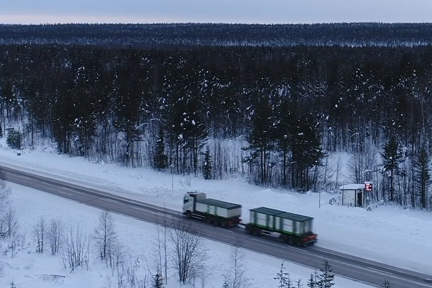
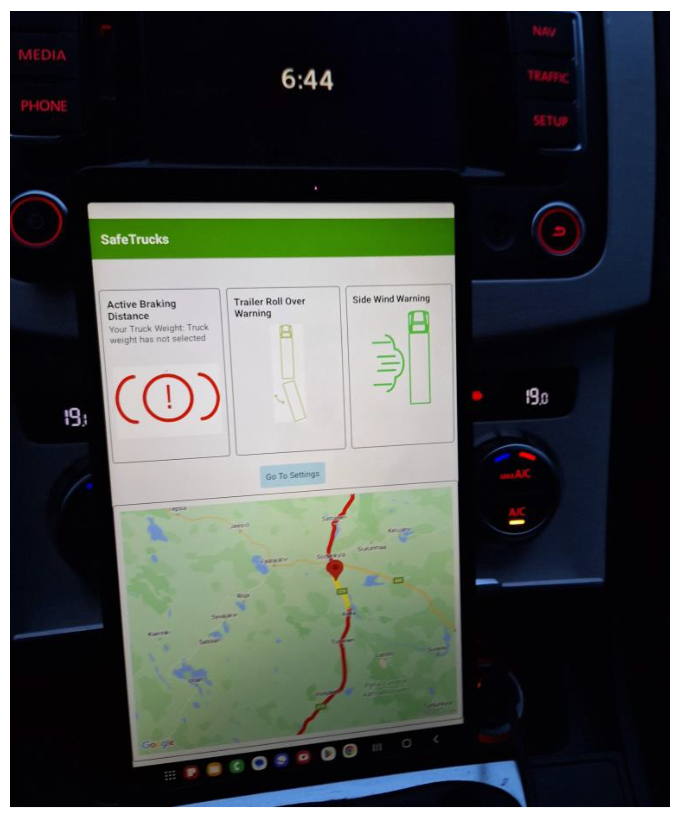
The pilot services are about to be evaluated by operative heavy vehicle fleet in real traffic environment using services continuously during the operative drive. The main operative fleet is hosted by VR Transpoint, whose trucks carry mining goods from Kevitsa mine located North from Sodankylä into Kemi harbour. The route in shown in the left-hand side map of Figure 4 (The northernmost one of the two routes). VR Transpoint has been co-operating with FMI through this fleet already since 2017, when FMI deployed on-board road weather sensors to several trucks in this route. The observations were used to provide a specific enhanced route weather in Intelligent Arctic Trucks project [10]. In the SafeTrucks piloting, the 2 vehicles still having on-board road weather sensors (Teconer RCM 411[2]) have SafeTrucks user interface application integrated to the data collection unit. They collect road weather data from the route to enhance SafeTrucks pilot services data, but also use the pilot services as end users. Similar kind of system has been prepared for two trucks hosted by Neste and Lappia institute, which operate in Oulu and Kemi area. (the southernmost routes in the left-hand side map of Figure 4). These trucks are equipped with Vaisala MD30 road weather sensors [4] and Taipale Telematics Sensior system as on-board data. In addition to these, several VR Transpoint trucks are equipped with pure end user system with just user interface tablet pc device for pilot services. The user device with pilot service user interface is viewed in Figure 7 below.
The pilot services have been in operation only during autumn 2024, so there is no experience of using the services in any winter conditions yet. We have requested user experience comments from the drivers, but they are obviously very initial and focus on the user interface practical issues. The map view in user interface should be larger, especially when there are no active warnings. The warnings themselves tend to be active simultaneously, which is confusing for the driver. Especially the sidewind and trailer roll-over/sliding warnings are found to be too sensitive. This is expected feedback, as the approach was to start with sensitive mode to test the warning system). The fine-tuning of services continues through online updates of the application, and more sophisticated feedback will be collected later.
4.3. Digital Twin
When composing this paper, there was no evaluation information available from Digital Twin simulations yet. Digital Twin modelling of active truck trailer and active tractor trailer is progressing in Software-in-the-Loop (SIL) simulation entity composition work between CM labs and NRC-CNRC, Hardware-in the-loop (HIL) active control systems development for Active Trailer Steering (ATS) by CM labs, NRC-CNRC and Simard Suspensions, and Driver-in-the-Loop (DIL) simulator software framework with motion and haptics software for trucks construction by Traxara Robotics, NRC-CNRC and CM labs. The evaluation results from these systems will be presented and analysed when available, in future publications.
Figure 7.
Pilot service device and user interface.
5. Discussion
The heavy vehicles and trailer combinations are vulnerable to severe winter weather conditions, and when facing accident, they always have higher risk of causing fatalities and material damage or total traffic stops. SafeTrucks project targets to reduce these risks by introducing more sophisticated road weather and safety services tailored individually to each heavy vehicle unit and its dynamics. We have generated a set of pilot services for heavy vehicles and trailer combination entities, which are offered in special user interface within tablet pc and evaluated throughout the project. This paper overviews the general approach of the project, system architecture with pilot vehicular services and very preliminary evaluation results of the pilot system and related tyre and communication entity evaluation. Future work consists of fine-tuning the services in co-operation with Digital Twin entity, while letting them operate through the winter season and harsh winter conditions. The results so far are already very promising, we are one step closer to the ultimate goal, zero fatalities in the traffic environment.
Acknowledgments
This work has been supported by Business Finland and the Eureka Xecs program. The authors wish to thank our partners of the project in Finnish Meteorological Institute, University of Oulu, Nokian Heavy Tyres, Ahola Transport, Neste and Taipale Telematics in Finland, and NRC-CNRC, CM-Labs, Simard Suspensions Inc., Traxara Robotics Inc, Manac inc., Micro Engineering Tech. Inc. and Vehicle Technology Centre in Canada.
Conflicts of Interest
The authors declare no conflicts of interest.
References
- Kangas M, Heikinheimo M., and Hippi M., “RoadSurf – a modelling system for predicting road weather and road surface conditions”, Meteorol. Appl. 22, p. 533-544, 2015.
- Teconer 2016, Road Condition Monitoring sensor RCM 411. Technical report. Teconer.
- Teconer 2021, Road Condition Monitoring sensor RCM 511. Technical report. Teconer.
- Vaisala 2024, Vaisala Mobile Detector MD30, Product spotlight. Vaisala.
- Vaisala 2021, Road Weather Station RWS200 for roads, rail, and runways. Vaisala RWS200 Product Catalog. Vaisala.
- Fior J. and Cagliero L., "Correlating Extreme Weather Conditions with Road Traffic Safety: A Unified Latent Space Model," in IEEE Access, vol. 10, pp. 73005-73018, 2022.
- Ojanperä T., Scholliers J., Sukuvaara T., Yastrebova A., Miekkala T., Pyykönen P., Mäenpää K., Salkari I., Laakso J., Huuskonen O., Zhang H., Kinawi H., Nyrhinen H. and Eloranta P., “Piloting and Evaluation of 5G-Enabled Road Safety and Cybersecurity Services”, EUCNC/6G Summit, 6-9 June 2023, Gothenburg, Sweden.
- Sukuvaara T., Mäenpää K., Honkanen H., Hippi M., Karsisto, V. and Siltanen T.,” Advanced road safety by dynamics and road weather services tailored for individual heavy vehicles”, IAVSD 2023 Symposium, 21.-25.8.2023, Ottawa, Canada.
- Sukuvaara T., Mäenpää K., Honkanen H., Hippi M. and Karsisto, V. “Road weather and safety services tailored individually to heavy vehicles”, TRA 2024, 15.-18.4.2024 Dublin, Ireland.
- Sukuvaara T., Mäenpää K., Stepanova D. and Karsisto V.,”Vehicular Networking Road Weather Information System Tailored for Arctic Winter Conditions”, International Journal of Communication Networks and Information Security (IJCNIS) Vol. 12, No. 2, August 2020, pp. 281-288.
- Sukuvaara T., Mäenpää K., Perälä T., Hippi M and Rimali A.,” Winter testing track environment for the intelligent traffic road weather services development”, 20th International Road Weather Conference on the 14-16th of June, 2022 – SIRWEC2022, Druskininkai, Lithuania.
- Sukuvaara T., Mäenpää K., Perälä T., Stepanova D. and Hippi M., " Enhanced Road weather services tailored for autonomous vehicles”, in proceedings of PIARC 2022 XVI World Winter Service and Road Resilience Congress, virtual conference, February 7-11, 2022 hosted from Calgary, Canada.
- Hippi M.,Sukuvaara T., Mäenpää K. and Perälä T, “Weather service to support autonomous driving in adverse weather conditions”, 20th International Road Weather Conference on the 14-16th of June, 2022 – SIRWEC2022, Druskininkai, Lithuania.
- Pirnes V., Tuutijärvi M. and Haataja M., ”HCT-puutatavarayhdistelmien ajoseuranta ja stabiliteettitutkimus, yhdistelmien liikkuvuus ja ajovakaus”, University of Oulu, Mechanical Engineering, Report 5, 2018, http://urn.fi/urn:isbn:9789526221441.
- Karsisto V., “RoadSurf 1.1: open-source road weather model library”, Geoscientific Model Development, Vol 17, No 12, pp. 4837–4853, 2024. [CrossRef]
Figure 1.
SafeTrucks research objectives presented as a platform.
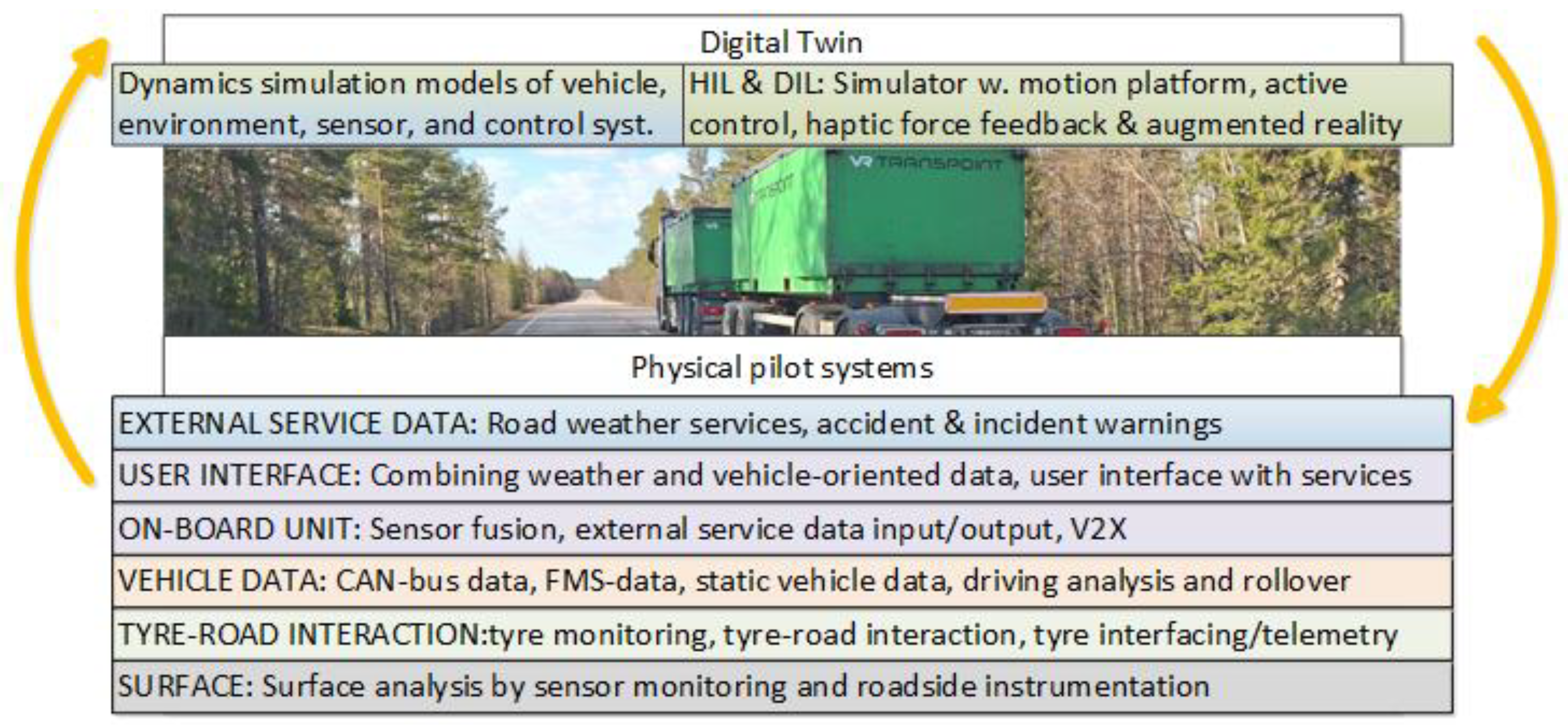
Figure 2.
Combined platform of pilot systems and Digital Twin modelling.
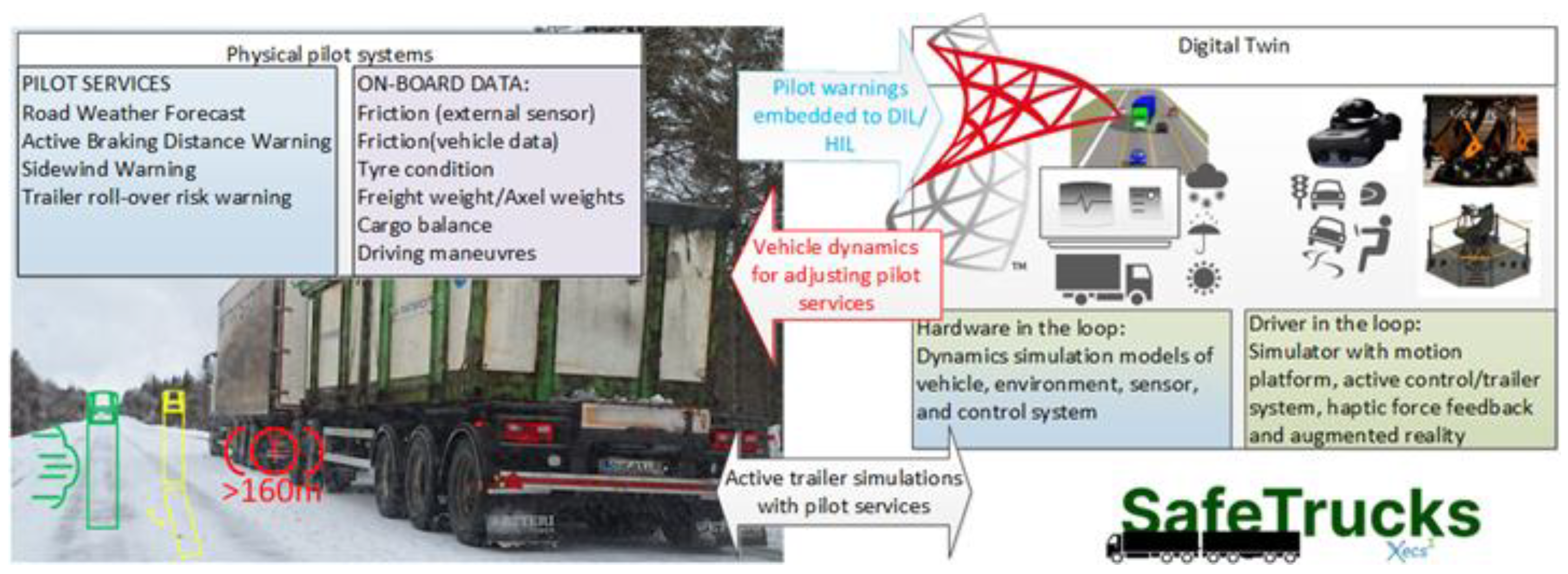
Figure 3.
Three levels of SafeTrucks alerts active braking distance (top), trailer roll-over/sliding risk (middle) and side wind warning (bottom).
Figure 3.
Three levels of SafeTrucks alerts active braking distance (top), trailer roll-over/sliding risk (middle) and side wind warning (bottom).
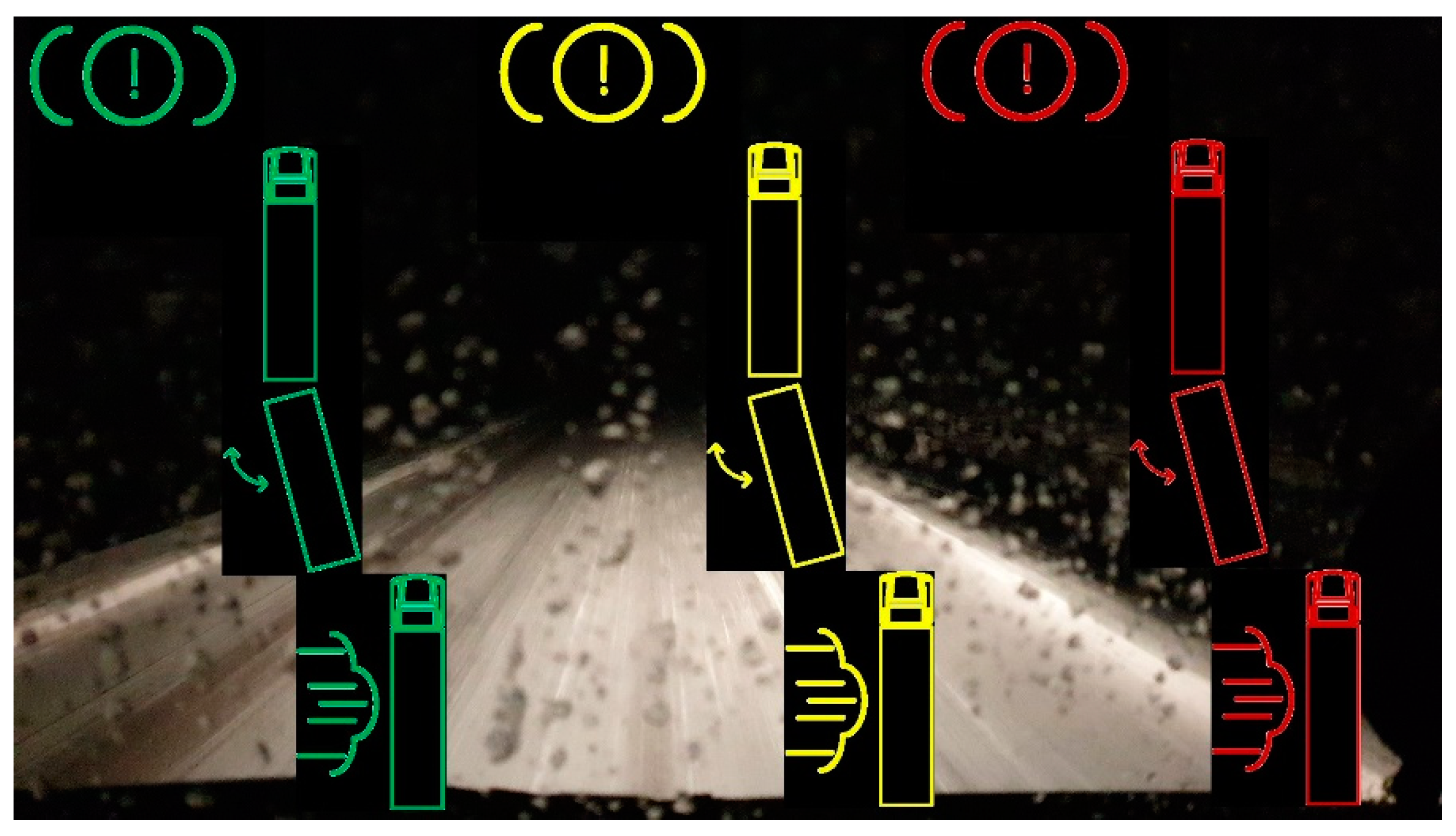
Figure 4.
The piloting locations in Northern Finland (map Googlemaps).
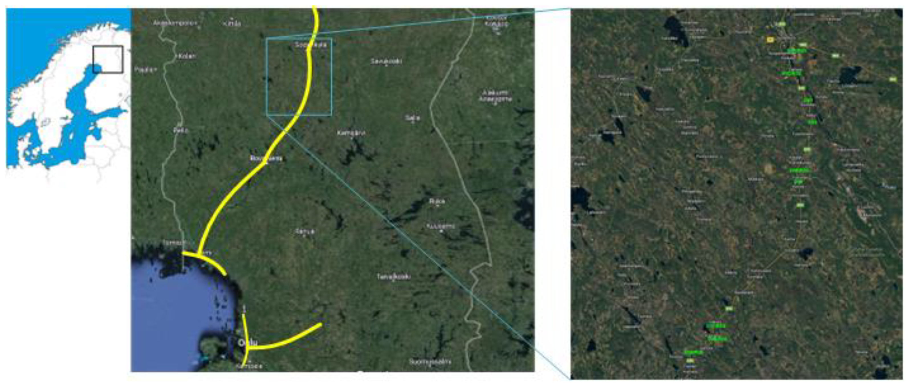
Figure 5.
Sod5G test track for intelligent traffic road weather services development.
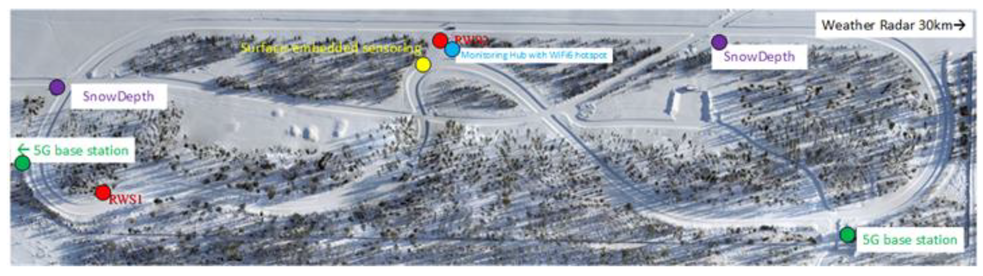
Figure 6.
ITS-G5 (left) and C-V2X (right)range in test measurements.
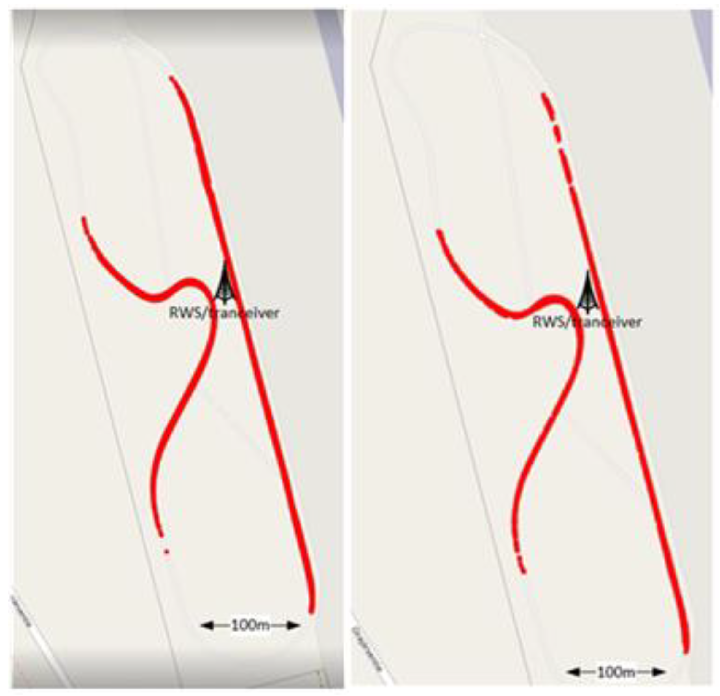

Table 1.
Vehicle-tailored safety services envisioned.
| Service | Contents | Presented data |
|---|---|---|
| Road/route weather information | Real-time road weather forecast information into the current location and current route ahead. User interface background service presented when no active warnings. | Map with route and current location, weather information as color-coded line in the route. |
| Active braking distance | Real-time estimate of braking distance, based on road friction (estimate & forecast), tyre conditions, vehicle speed, weight and axel-level weights | Braking distance alert symbol, in red font when critical, yellow/green in lower levels. |
| Side wind warning | Real-time estimate of side wind effect to the vehicle and trailer, based on localized road weather forecast, vehicle and trailer dimensions and weight and speed of the combination | Extreme, high and moderate side wind warning color-coded symbol. |
| Trailer roll-over/sliding risk | Real-time estimate of trailer roll-over/sliding risk, based on friction (estimate & forecast), vehicle dynamics (speed, tyre condition, trailer weight and axel-level weights, lateral movement of vehicle and trailer) | Extreme, high and moderate trailer roll-over risk as color-coded symbol. |
Table 2.
Throughput in ITS-G5 tests, each representing one test drive lap.
| Connection points | Mean throughput (Mbits/sec) | min 95% confidence interval | max 95% confidence interval |
|---|---|---|---|
| 43.0 | 4.378 | 4.304 | 4.453 |
| 82.0 | 4.1299 | 3.995 | 4.265 |
| 62.0 | 4.227 | 4.094 | 4.3597 |
| 90.0 | 4.284 | 4.213 | 4.3547 |
Table 3.
Latency in ITS-G5 tests, each representing one test drive lap.
| Connection points | Mean latency (ms) | min 95% confidence interval | max 95% confidence interval |
|---|---|---|---|
| 130.0 | 4.874 | 4.771 | 4.977 |
| 585.0 | 6.294 | 3.439 | 9.149 |
| 584.0 | 4.8584 | 4.783 | 4.933 |
| 577.0 | 6.2674 | 3.562 | 8.973 |
| 586.0 | 4.896 | 4.799 | 4.993 |
| 578.0 | 7.937 | 3.687 | 12.187 |
| 642.0 | 4.771 | 4.743 | 4.800 |
| 607.0 | 4.772 | 4.737 | 4.808 |
| 104.0 | 4.723 | 4.675 | 4.772 |
| 790.0 | 4.767 | 4.740 | 4.793 |
Table 4.
Latency in C-V2X tests, each representing one test drive lap.
| Connection points | Mean latency (ms) | min 95% confidence interval | max 95% confidence interval |
|---|---|---|---|
| 323.0 | 28.604 | 27.963 | 29.246 |
| 262.0 | 29.206 | 28.508 | 29.904 |
| 262.0 | 28.8543 | 28.321 | 29.388 |
| 223.0 | 28.840 | 28.112 | 29.568 |
| 233.0 | 28.990 | 28.258 | 29.722 |
| 213.0 | 29.013 | 28.255 | 29.771 |
| 407.0 | 29.896 | 29.322 | 30.470 |
Table 5.
Throughput and latency in 5G communication tests measured in separate events, all drive laps collected into a single measurement session.
Table 5.
Throughput and latency in 5G communication tests measured in separate events, all drive laps collected into a single measurement session.
| Connection points | Mean throughput (Mbits/sec) | Mean latency (ms) | min 95% confidence interval | max 95% confidence interval |
|---|---|---|---|---|
| 1197.0 | 6.165 | - | 6.029 | 6.301 |
| 1197.0 | - | 35.109 | 33.754 | 36.463 |
Disclaimer/Publisher’s Note: The statements, opinions and data contained in all publications are solely those of the individual author(s) and contributor(s) and not of MDPI and/or the editor(s). MDPI and/or the editor(s) disclaim responsibility for any injury to people or property resulting from any ideas, methods, instructions or products referred to in the content. |
© 2024 by the authors. Licensee MDPI, Basel, Switzerland. This article is an open access article distributed under the terms and conditions of the Creative Commons Attribution (CC BY) license (http://creativecommons.org/licenses/by/4.0/).
Copyright: This open access article is published under a Creative Commons CC BY 4.0 license, which permit the free download, distribution, and reuse, provided that the author and preprint are cited in any reuse.


