Submitted:
13 October 2024
Posted:
15 October 2024
You are already at the latest version
Abstract
In order to better understand the temporal and spatial variation of canopy rainfall interception with watershed, In this study, the remote sensing observation data at the regional scale were coupled with the vegetation canopy rainfall interception model constructed by A.P.J. DEROO for validation, and the spatial variation trend of rainfall interception was analyzed through linear and nonlinear trends, and the rainfall interception was quantified and the influencing factors were analyzed at different altitudes and regions at time scales. The results show that: (1) Compared with the PML_V2 and measured values, the root mean square errors of the simulated rainfall inter-ception values are 5.69 and 3.37, and the effective factor are 0.66 and 0.64, respectively, which confirms the reliability of the A.P.J.DE ROO model in estimating rainfall interception in Beijing. (2) From 2005 to 2020, the annual interception volume and interception rate showed an upward trend, with the largest increase trend in 2005 at 3.8%/a, and the interception volume reversed in 2015, changing from an increase (6.5 mm/a) to a decrease (-5.8 mm/a). (3) The Theil-Sen Median trend was used to test the spatial variation trend of rainfall interception in the canopy in Beijing, with an increasing trend of 89.5%, a decreasing trend of 8.7%, and a basically unchanged area of 1.8%. Through the BFAST01 mutation test, 4.4% of the canopy rainfall interception in the whole region had mutations, and the southern mutation detection type accounted for the largest proportion. (4) Leaf area index, rainfall, canopy height and slope had the strongest explanatory power for canopy interception in the monthly scale analysis, while wind speed and temperature were weaker. The results of this study provide new insights into the analysis of spatial and temporal changes in canopy interception in Beijing, which can help to accurately assess the impact of forest ecosystems on regional water cycles and provide scientific and practical insights for water resource man-agement.
Keywords:
Vegetation canopy interception
; rainfall
; remote sensing
; BFAST improved model
; Beijing
1. Introduction
Project to return farmland to forest promotes regional reforestation and environmental improvement, Nevertheless, extensive afforestation has led to an increase in rainfall interception within the vegetative canopy, which has subsequently resulted in a reduction in regional water yield. It prompts consideration of the conflicts that arise between ecosystems and human activities in areas where water is scarce[1,2]. The water cycle plays an integral role in the climate cycle system. The spatial and temporal vagriations in the water resources of a river basin are inevitably influenced by the impact of vegetation cover on the elements of the water cycle[3]. The interception of rainfall by vegetation canopies represents a crucial component of the ecological water cycle. However, this phenomenon has historically been underestimated in numerous hydrological models, resulting in inaccuracies in the simulation of rainfall runoff[4,5]. It is therefore important to understand the rainfall interception capacity of vegetation in a region if one is to evaluate the water-holding capacity of vegetation and soil erosion processes in that region on a scientific basis[6].
Canopy rainfall interception is defined as the process by which rainfall that is intercepted and stored by the vegetation canopy is temporarily unable to reach the ground[7,8]. An accurate estimation of canopy rainfall interception is a fundamental prerequisite for the exploration of ecohydrological processes, which represent a crucial component of maintaining ecosystem water balance[9]. The direct measurement of canopy rainfall interception is not a viable option; therefore, traditional methods have been developed to estimate this phenomenon. These methods involve determining the difference between total rainfall and within-forest rainfall and trunk stem flow[10]. Alternatively, assessment may be conducted through the examination of individual leaves or entire plants, with the findings subsequently extrapolated to encompass entire plant communities. This means that a large number of survey instruments and larger areas are required for collection, making it difficult to generalise and apply to regional scales. [11]. Furthermore, the erratic distribution of precipitation and the heterogeneous composition of vegetation necessitate the implementation of prolonged monitoring periods to ensure the conservation of an area. This approach inevitably increases the time and financial resources allocated to field measurements[12]. Consequently, model simulations can assist in resolving this issue by estimating canopy interception based on available meteorological variables and vegetation canopy parameters[13].The conceptual models proposed by Gash[14]. and Rutter[15] have been widely employed in both domestic and international contexts. These models are founded upon empirical data and incorporate climatic and canopy parameters, offering a robust physical mechanism that can be extrapolated across spatial and temporal scales. With the development of satellite technology, remote sensing has become a powerful tool for extracting spatial and temporal information related to land surface processes due to its advantages of wide coverage, low cost, and applicability to undocumented areas, etc. Wei He[16], Zhang Q[17] and Yao-Kui Cui[18] used the improved Gash model to estimate and validate the accuracy of the model for canopy rainfall interception at regional and national scales, respectively. Zixin Sun[19] used remote sensing data coupled with the A.P.J. DEROO model to achieve the estimation of rainfall interception in the canopy of the Qinba Mountains, so large-scale quantification and assessment of rainfall interception through remote sensing data coupled with rainfall interception models has become a research hotspot in recent years.
Beijing is an important strategic location in China, as the project of returning farmland to forest has greatly increased the green cover rate of Beijing and improved the ecological environment, but most of the vegetation afforestation areas have serious soil erosion, soil sanding and soil quality degradation, resulting in difficulties in land establishment and poor quality of arable land[20], Assessing changes in ecohydrological process fluxes following large-scale afforestation projects is therefore essential for rational water management in ecosystems and effective climate-responsive planning[21]. Considering the importance of water conservation in Beijing and the severity of soil erosion problems, it has become particularly urgent to study canopy interception and its ecohydrological effects in Beijing. Chen Lihua[22] and Lu Junfeng[23] modelled canopy interception of typical vegetation in the Beijing mountain region with field monitoring in Jiufeng and Miyun, respectively; however, the quantification of canopy interception in the Beijing region was done at small scales and could not be replicated in other regions or at large scales. It is necessary to analyse the rainfall interception of canopy vegetation in the mountainous areas of Beijing at the regional scale. In this study, the A.P.J. DEROO canopy interception model adapted to remote sensing was used to estimate the rainfall interception of canopy vegetation in Beijing at a large scale, evaluate the rainfall interception based on the latitude of time and altitude, and explore the key factors affecting rainfall interception in Beijing.
2. Materials and Methods
2.1. Study Area
Beijing is located in the northern part of the North China Plain, with a geographical range of 39°26′-41°05′N, 115°25′-117°35′E, and a land area of 1.64×10⁴ km2. The topography of Beijing is high in the northwest and low in the southeast, with the Taihang Mountains in the western part of the mountainous terrain and the Shanxi Plateau adjacent to the city, and the Yanshan Range in the north[24]. The highest peak of the Yanshan in Beijing is Dongling Mountain, with an altitude of 2303 m, located in the northwestern part of Mentougou District[25]. The mountains are relatively scattered, with granite, gneiss and gravel as the main constituents, interspersed with mountain basins and valleys, and the terrain is relatively open. Upstream of the Miyun reservoir are the Chaohe and Baihe river systems, upstream of the Huairou reservoir is the Huaihe river system, and upstream of the Guanting reservoir (within Beijing) is the Guihe river. Beijing's forests are mainly located in the northern and western mountainous areas of the city, with the main forest types being natural forests such as the cypress group, the greasy pine group and the oak group. As shown in Figure 1.
2.2. Data Collection and Processing
2.2.1. Rainfall Data
The data set comprises daily meteorological observations from meteorological observation stations in Beijing from 2005 to 2020. The data have been sourced from the data centre of the China Meteorological Station Sharing Network (/https://data.cma.cn/). The 16-year daily rainfall data for Beijing was interpolated using the ArcGIS inverse distance interpolation method to obtain the monthly and annual rainfall data for the study area.
2.2.2. Leaf Area Index (LAI)
The LAI product employed in this study was derived from the MCD15A3H product released by NASA(ladsweb.modaps.eosdis.nasa.gov). The data pertaining to the leaf area index were subjected to a series of processes, including mask extraction, resampling and raster computation, with the objective of obtaining raster data that exhibited the same resolution and row and column numbers as the rainfall data. MCD15A3H is based on the combination of Terra MODIS and Aqua MODIS, and the 0.5km LAI generated by the inversion of MODIS remotely sensed data has a high accuracy, which has been well validated in the Northeast, North, and South-Central zones of China[26].
2.2.3. Measured Data from Sample Plots
A total of 18 sets of measured data from Beijing, including field measurements and literature searches, were employed to conduct a comprehensive assessment of the accuracy of the Beijing canopy rainfall interception simulation. The validated test area is situated in a typical location approximately 5 km upstream from the Miyun Reservoir in Beijing. This area forms part of the demonstration zone for Beijing's water source forest protection programme, spanning a geographical range between 116°31′-117°31′ E and 40°13′-40°48′ N. The interception of rainfall in a typical plantation forest was monitored through the utilisation of sample plot surveys, the observation of rainfall within and beyond the forest boundaries, and the measurement of trunk stem flow over the course of the 2017-2020 period. The value was assumed to be equivalent to the difference between gross and net rainfall, as determined through the application of the water balance method[27]. To wit:
where: is the canopy rainfall interception (mm), Pg is the rainfall outside the forest (mm), N is the net rainfall (mm), TF is the penetrating rainfall (mm), and SF is the stem flow (mm).
I=Pg-N=Pg-(TF+SF)
2.3. Research Methods
2.3.1. Estimation of Rainfall Interception Capacity of Vegetation Canopies
A.P.J. DEROO put forth a novel canopy rainfall interception model founded upon a geographic information system (GIS) environment. This model is calculated in accordance with the leaf area index and precipitation that influence canopy interception. The theoretical assumption of this formula is that canopy rainfall interception() = 0 when rainfall()= 0, and()= maximum interception()when→∞[28], The formula for the model is as follows:
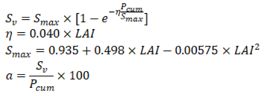
whereis the cumulative vegetation canopy rainfall interception (mm), is the cumulative rainfall (mm), is the maximum vegetation canopy interception capacity (mm), η is the correction coefficient, LAI is the Leaf Area Index (LAI), and a is the rainfall interception rate (%) of the vegetation canopy.
2.3.2. Model Accuracy Evaluation and Validation
The performance of the A.P.J. ED ROO model was evaluated by applying the root mean square error (RMSE), effective coefficient (EF) and correlation coefficient (R) using the canopy intercepted evapotranspiration raster data from the China regional PML_V2 terrestrial evapotranspiration and total primary productivity dataset[29] and the measured data from Beijing City as the baseline.
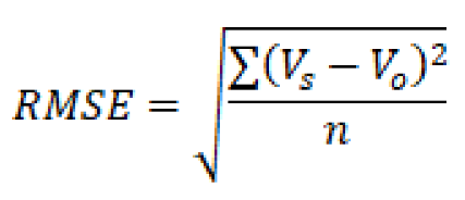
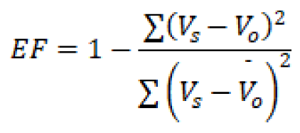
where is the simulated value of canopy interception and is the measured value of canopy interception, RMSE is used to measure the deviation between the simulated and measured values of canopy interception, the smaller the value of RMSE, the higher the prediction accuracy of the model; EF is used to characterise the effectiveness of the model.
2.3.3. Analysis of Linear Trends in Canopy Rainfall Interception
The objective of this study was to investigate trends in Beijing canopy interception. To this end, a non-parametric Theil-Sen Median trend analysis was employed, which estimates trends based on the concept of median slope, thus avoiding the reliance on the distributional pattern of data[30], The formula for its calculation is:
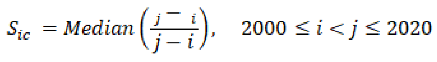
When >0, it means that the canopy interception shows an increasing trend, and <0, it means that the canopy interception shows a decreasing trend.
The Mann-Kendall trend analysis is a non-parametric statistical test that is employed to ascertain the existence of a trend and its significance in time-series data. The test does not require the data to conform to a particular distribution, and therefore does not require the shape of the distribution of the data to be known[31], The calculations are publicised below:
Define the Z statistic as: 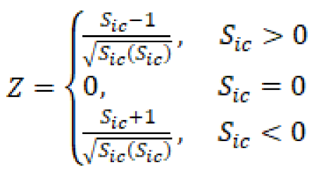 which,
which,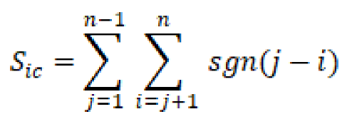
2.3.4. Canopy Rainfall Interception Mutation Test
A non-linear line analysis of the BFAST01 model was employed to investigate the abrupt variability of rainfall interception in the mountainous regions of Beijing, utilising both linear and non-linear trend analysis. The BFAST01 model represents an advancement over the original BFAST model in that it incorporates both seasonal and trend-based considerations. It is capable of detecting significant shifts in the time series while filtering out minor structural changes. Additionally, it identifies the single most influential mutation point and divides the overall trend into two major components, as opposed to multiple smaller trend segments[32]. These two steps are to estimate the possibility of the existence of breaks and structural changes in the time series, mathematically, BFAST applies segmented linear trend and seasonal models using decomposition methods to obtain the trend and seasonal components respectively[33].
is the value for time period t; is the trend component; is the seasonal component; is the residual component; and t is the time horizon of the observation.
In this study, we loaded and analysed the latest BFAST01 package in Gitee (https://gitee.com/three-poles/Time-series-analysis) using the R environment with the objective of detecting all breakpoint types of canopy interception in Beijing. Furthermore, we referenced related studies with the intention of classifying the change characteristics of canopy interception[33], As illustrated in Figure 2.
2.3.5. Analysis of Factors Influencing Canopy Rainfall Interception
GeoDetector is a statistical method for analysing spatial heterogeneity and identifying influencing factors. It comprises two main components: a factor detector for exploring the divergence of the geographic dependent variable Y and the explanation of Y by each driver X; and an interaction detector for identifying interactions between different risk factors. In this study, eight indicators of vegetation characteristics (leaf area index, canopy height) and eight meteorological conditions (rainfall, rainfall intensity, wind speed, air temperature, sunshine duration) were selected for investigation. Factor probes and interaction probes were employed to ascertain the explanatory power of the influencing factors on the rainfall interception capacity in Beijing[35].
3. Results and Analyses
3.1. Validation of Model Accuracy
In this paper, the A.P.J. DEROO model was used to simulate canopy rainfall interception and interception rate, and to verify the reliability of the model simulation results, measured data from Miyun as well as data obtained from the literature were collected to verify the accuracy of the simulated values of interception rate. The actual sites are mainly located in Miyun Reservoir, Jiufeng Forest Park, Miaofeng Mountain, Jiulong Mountain and Badaling, and are located in the eastern, northern and western mountain ranges of the study area. As shown in Figure 3, The model correlated significantly with both the PML_V2 dataset (r=0.83, p<0.01) and the measured data (r=0.9, p<0.01), with Root Mean Square Error (RMSE) of 5.69 and 3.37 respectively, which is within the acceptable error range, and Effective factor (EF) of 0.66 and 0.64 respectively, i.e. the model simulation results are more reliable compared to the remotely sensed products and the In-situ fixed point measurements.
3.2. Changes in Rainfall Interception Time in the Beijing Canopy
The trend of interannual interception and interception rate changes in Beijing mountainous areas from 2005 to 2020 was mainly increasing (Figure 4), the interannual and rainy season interception trends were similar, the non-rainy season canopy interception changes were not large, with a range of 4. 19-23.25 mm, indicating that the time affecting interception was mainly concentrated in the rainy season (June-September), and the range of interannual interception changes was between 29.84~98.31 mm, with a range of 29.84 mm in 2005, which was significantly lower than the multi-year average of 74.77 mm. the trend of interception shifted in 2015, with 6.48 mm/a to -5.83 mm/a. The highest and lowest values of interception occurred in 2005 (7%) and 2018 (15.6%), respectively, The mean annual precipitation showed a negative correlation with the change in the interception rate.
3.3. Spatial Pattern of Rainfall Interception in the Beijing Canopy
3.3.1. Spatial Distribution of Canopy Precipitation Interception
Using the model coupled with remote sensing data to obtain rainfall interception data in the canopy of Beijing from 2005 to 2020, and to map the spatial distribution of cumulative vegetation rainfall interception in the mountainous areas of Beijing (Figure 5). From the figure, it can be seen that the spatial distribution pattern of rainfall interception and interception rate in the mountainous areas of Beijing is similar, and in general, the interception capacity of the western, northern and eastern mountain ranges is significantly higher than that of the central and southern plains, and the interception capacity of the study area is classified into five grades using the natural breakpoint method. The area of the extremely high interception zone (90-115 mm) accounted for 28.1% of the total area, the high interception zone (75-90 mm) for 27.1%, the intermediate interception zone (59.5-79.2 mm) for 30.1%, the low interception zone (27.5-59.5 mm) for 12.3% and the ultra-low interception zone (0.5-27.5 mm) for 2.4%. The extremely high and high interception zones are mainly distributed around the Jundu Mountain Range, Miyun Reservoir, the western mountain range (the border between Mentougou and Fangshan districts) and Jinhai Lake. The low interception zone is mainly distributed in the North China Plain zone around the city center and near Guanting Reservoir in the Jundu Mountain Range, which has similar characteristics to the distribution of vegetation cover in Beijing[36]. From a zoning perspective, there are similar characteristics of interception volume and interception rate, with high interception volume areas having relatively high interception rates and vice versa. The order of high interception areas is Huairou (87.1mm) > Miyun (83.9mm) > Yanqing (83.6mm) and the order of interception rate is Huairou (14%) > Miyun (13.05%) > Yanqing (12.58%). Low interception areas were ranked as Chaoyang (47.16 mm) < Fengtai (47.58 mm) < Daxing (57.13 mm) Low interception areas were ranked as Chaoyang (7.62%) < (7.87%) Fengtai < (9.13%) Daxing, which is similar to the characteristics of low interception area zones.
Analysed from the perspective of altitude zoning, the interception capacity of the vegetation canopy shows a certain divergence law: The interception capacity of the vegetation canopy gradually increases with increasing altitude, especially below 2000m, where cultivated land and grassland types predominate, and the leaf area index increases with increasing altitude until the transition zone of shrubs and forests. The peak was reached between 1500m and 2000m above sea level, mainly because the high-altitude area is located in the densely vegetated areas such as West Mountain and Jundu Mountain in Beijing, which are rich in rainfall, and the interception capacity (95.16mm) and interception rate (15.91%) reached the maximum.
2.3.2. Spatial Trends in Canopy Rainfall Interception Capacity
The combination of Theil-Sen median trend analysis and Mann-Kendall test with superposition analysis can effectively respond to the spatial change characteristics of rainfall interception capacity of vegetation canopy in Beijing from 2005 to 2020. According to the actual situation of this study, there is basically no situation where the interception capacity is equal to 0. Therefore, the interception capacity range of -0.05-0.05 was classified as stable and unchanged, the value of more than 0.05 was classified as an increasing area, and the value of less than 0.05 was classified as a decreasing area, and the results of trend were classified into five categories (Table 1) to illustrate the spatial trend and significance of changes. Rainfall interception in the vegetation canopy showed an overall increasing trend, with the increasing trend accounting for 89.5% of the total canopy interception area, and only 8.7% of the area showing a decreasing trend. From the distribution of the changing trend (Figure 6), the significantly increasing areas were mainly distributed in Mentougou District, Changping District, Yanqing District and around Miyun Reservoir, and the extremely significant increasing areas were mainly distributed in Mentougou District, which are all water protection areas in Beijing and are also the areas where the farmland return to forest project has been implemented, indicating that the results of large-scale afforestation in Beijing over the past 20 years have been excellent and have made a qualitative Improvement to the local ecological environment. The area with decreasing interception capacity is mainly distributed in Daxing District, Tongzhou District and the eastern part of Fangshan District in the southern plains of Beijing, which is not obvious in the decreasing trend, and is mainly dominated by cultivated land, with sporadic distribution of trees such as poplar and Pinus tabuliformis, etc., and coupled with the expansion of urban infrastructure in recent years, the interception capacity has slightly decreased in the decreasing trend.
BFAST01 breakpoint detection was used to determine the distribution of breakpoints in the interannual trend of rainfall interception, which compensated for the inadequacy of Theil-Sen median trend estimation and the Mann-Kendall test, which did not take into account the breakpoints in the long-term variability of interception, and the results of breakpoint detection are shown in Table 2, with monotonically decreasing (with no breakpoints) accounting for 2. 7 % of the area, monotonically increasing (without breakpoints) 92.9 %, the area share of the breakpoint type is 1.2 % and 0.03 % respectively, and monotonically increasing (with positive breaks) and reversing (from decreasing to increasing) have the smallest share, accounting for only 0.01 % of the area. In the interception raster data, the distribution of breakpoint detection from 2005 to 2020 was extracted based on the direction of the relationship between the trend components of the line segments fitted to their time trajectories. The statistics from ArcGIS showed that there was a sudden change in canopy rainfall interception in 4.4% of the area of the whole region, and the monotonically increasing area was mainly in the western mountain ranges, the Jundu mountain ranges and the Miyun Reservoir, which is a water conservation area, where the trend is basically uninterrupted. The decreasing trend is in the North China Plain south of Beijing, which is mainly dominated by arable land. The interruption type, i.e. the interception amount is disturbed and the trend changes in the opposite direction, is sporadically distributed in the areas of Haidian, Changping and Huairou, etc. The decreasing trend is in the North China Plain south of Beijing. The reversal type, where the canopy interception is disturbed in some way and changes in the opposite direction, is mainly found in Daxing and Tongzhou districts in southern Beijing.
2.5. Driver Analysis
2.5.1. Single-Factor Detection
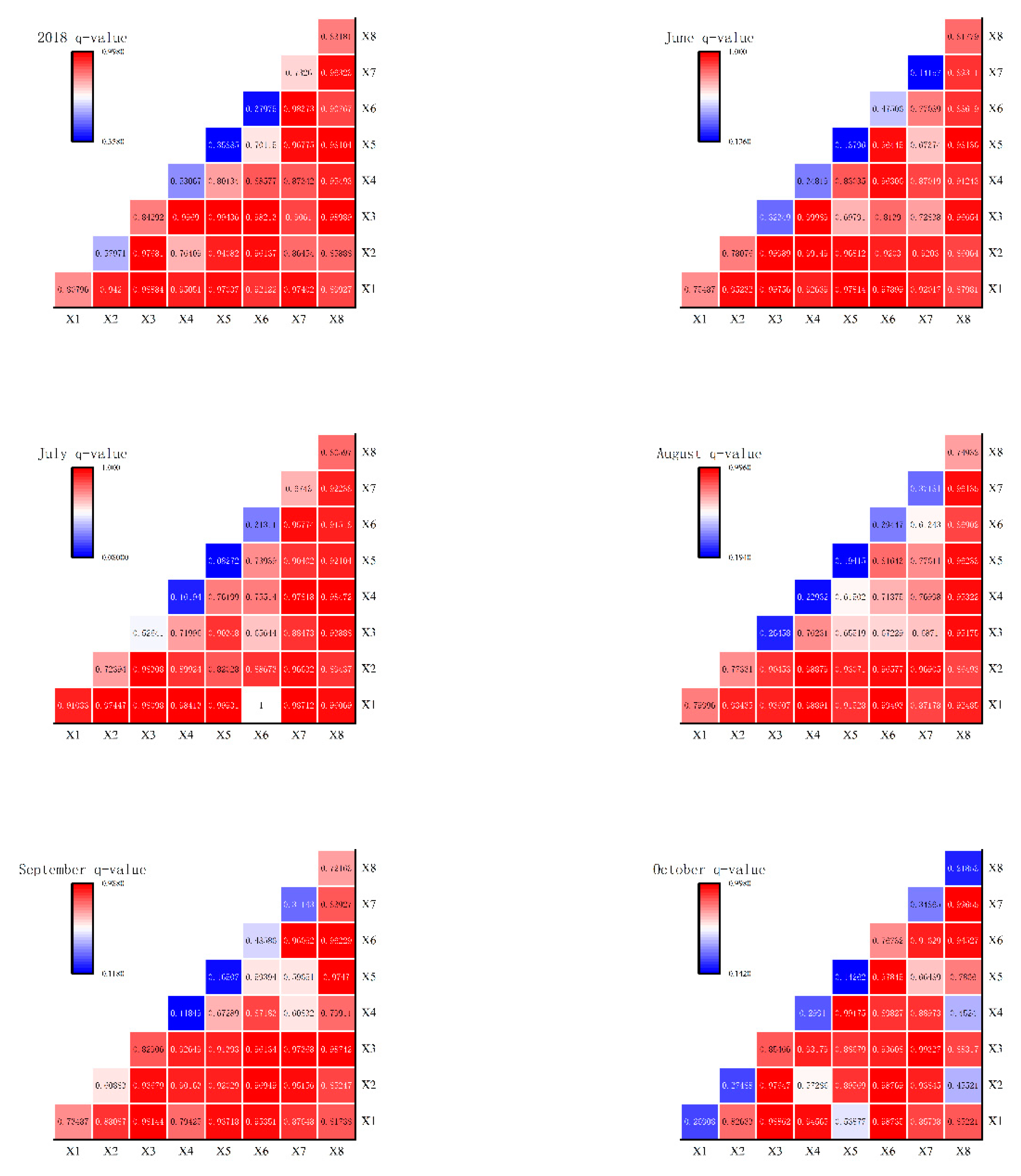
Driving forces were measured using geo-detectors for Beijing 2018 and June-October averages for each factor (Figure 7). On an annual average, the q of factors influencing canopy rainfall interception in Beijing was ranked as Leaf Area Index (LAI) > Slope > Rainfall > Canopy Height > Air Temperature > Sunshine Duration > Humidity > Wind Speed. The q value of leaf area index (LAI) was stable between 73% and 91% in each month, which had the strongest spatial explanatory power for canopy interception, while the q of LAI was only 27% in October, followed by rainfall and slope, which also had strong explanatory power for canopy interception, stable at 85% and 83%, respectively. Among them, rainfall and temperature had 86% and 77% q respectively in October, and the rest of the factors did not have high explanatory power in the dry season in October. Overall, the factors that had a greater influence on rainfall interception were leaf area index, rainfall, slope and canopy height, and the explanatory power of the other factors did not differ much, but the magnitude of the explanatory power varied slightly from month to month.
3.5.2. Reciprocal Factor Detection
The geodetector components explored the interactions between the factors and the results are shown in Figure 7. Overall, the factors showed strong synergistic effects, with the order of magnitude being canopy height ∩ wind speed (1) > leaf area index ∩ wind speed (0.99) > canopy height ∩ sunshine duration (0.99) > air temperature ∩ slope > (0.98) in 2018. In the interaction of all factors from June to October, the sequential groups with higher explanatory power in each month were ranked as follows: rainfall ∩ rain intensity (0.9998) > leaf area index ∩ rainfall (0. 9976) > rainfall ∩ canopy height (0.9998) Wind speed ∩ leaf area index (0.9814) in June; leaf area index ∩ temperature (1) > leaf area index ∩ wind speed (0.9993) > rainfall intensity ∩ slope (0.9847) > leaf area index ∩ rainfall intensity (0. 9841) August leaf area index ∩ temperature (0.9949) > leaf area index ∩ precipitation intensity (0.9889) > canopy height ∩ precipitation intensity (0.9888) > canopy height ∩ sunshine hours (0.969); September precipitation ∩ slope (0.9874) > leaf area index ∩ precipitation (0. 9814) > wind speed ∩ slope (0.9747) > rainfall ∩ sunshine duration (0.9737); October sunshine duration ∩ slope (0.9966) > rainfall ∩ sunshine duration (0.9933) rain intensity ∩ wind speed (0.9918) > leaf area index ∩ rainfall (0.9886). Rainfall, canopy height and leaf area index ranked first in the interaction by month.
Figure 8.
Q value of interaction factor detection.
4. Discussion
4.1. Evaluation of Model Accuracy Validation
In this study, a coupled remote sensing model based on MODIS LAI and meteorological data from the Beijing station was used to estimate rainfall interception in the vegetation canopy of Beijing, and the 0. 5kmL LAI generated by the inversion of MODIS remote sensing data had a high accuracy, which was well validated in the northeast, north China and south-central zones of China, and the daily, monthly and annual rainfall data obtained from the meteorological station rainfall data by interpolation using the inverse distance interpolation method has a high accuracy[37,38], And the rainfall interception values estimated by the coupled remote sensing model had high correlation coefficients, effective factor and low root mean square errors. The validation results of the model show that it is better compared with other remote sensing models for estimating rainfall interception[39], and the only measured data obtained are the raw data from five locations, namely the upstream of Miyun Reservoir, Badaling, Jiufeng and Jiulong. The measured data are much smaller than the remote sensing products, and the long time series of rainfall interception data in the obtained measured data are also very small, which is very limited in validating the accuracy of the model. Therefore, increasing the collection of regional rainfall interception data is the key to validating the accuracy of the model.
4.2. An Investigation of the Spatial and Temporal Characteristics of Canopy Rain Interception
Analysing the rainfall interception capacity of Beijing's mountainous areas on an annual scale, the overall interception volume and interception rate generally showed an increasing trend in the past 16 years. Possibly due to an average 15 % increase in trees such as cypress, oak and creosote bush over a 16-year period from 2005 to 2020.[40], Increased vegetation cover and leaf area index indicate that canopy interception capacity in Beijing is related to the distribution of vegetation types[41]. This is inextricably linked to the Beijing-Tianjin wind and sand source management, the ecological restoration of abandoned mines and the million-mu reforestation and greening project. From the point of view of temporal change, the increasing trend was most obvious in 2005, which may be caused by the rapid expansion of the leaf area index due to the completion of the plough-return project in the water-shedding area of Beijing under the Beijing-Tianjin Wind and Sand Source Treatment Project Plan[42]. The reversal in 2015 may be due to an increase in drought events and an increase in consecutive days without rain. At the spatial scale, the overall trend of canopy interception in Beijing was increasing by linear trend analysis, with the most obvious trend of increasing canopy interception in Mentougou District, and both increasing and decreasing in Fangshan District, where ecological restoration of mines and re-greening of vegetation in the western part of Beijing have played an important role since 2000, and there was a consistent trend with Jiang Meichen's evaluation of the restoration of vegetation in mines in the western part of Beijing[43], In Daxing and Tongzhou districts in the central and southern plains of Beijing, increasing and decreasing trends in canopy interception were interspersed, but a smaller trend predominated, which may be attributed to the decrease in ecological space in the plains due to the expansion of built-up areas, population growth, and the shift of cultivated land to suburban areas[44]. Changes in the spatio-temporal dynamic sequence of canopy breakpoints were detected by BFAST01, where abrupt spatial changes, extreme events and their induced natural disasters are the main factors leading to changes in breakpoints[45]. Beijing's water conservation area in the increasing trend detected by BFAST01 increased with negative breaks and decreased with positive breaks, sporadically distributed in Huairou, Changping and Miyun districts, the central and southern plains of Beijing, Daxing District, Tongzhou District and the eastern part of Fangshan District showed a predominantly decreasing trend, with the appearance of the situation from increasing to decreasing or from decreasing to increasing, which may be triggered by Beijing's extreme weather in recent years[46].
4.3. Exploring the Influencing Factors of Canopy Rainfall Interception in Beijing
Most of the studies that have been conducted on the effects of large-scale canopy interception have been considered on an annual scale and have not analysed the region on a monthly scale, so this study analyses the drivers of canopy interception on a monthly scale using a geoprobe. The spatial and temporal variation characteristics of canopy interception are mainly influenced by two factors, leaf area index and rainfall, which was confirmed in the study of the middle reaches of the Yellow River[47], however, in the monthly scale analysis, the period of more abundant rainfall yielded that canopy height and slope were also the main factors of canopy interception, which may be due to the influence of different heights and slopes on leaf area index as the month changes[48]. Therefore, it is very important to consider the effect of slope on rainfall interception when planning vegetation restoration, ecological construction and soil and water conservation. Through rational design of vegetation configuration and land management measures, the rainfall interception capacity of vegetation can be maximised, soil erosion can be reduced, and the health and stability of the ecosystem can be promoted. In October, when rainfall was low, the explanatory power of leaf area index (LAI), canopy height and slope factors on canopy interception was significantly reduced, and rainfall became the factor with the strongest explanatory power, and the strong synergy between LAI and each meteorological factor became the key to influence the spatial pattern of canopy interception.
5. Conclusions
In this study, the spatial and temporal variation characteristics of canopy interception in Beijing were investigated using the A.P.J. DEROO model with regional remote sensing and meteorological data in Beijing from 2005 to 2020, and the effects of key environmental variables on interception were also investigated:
(1) The root means square errors of the simulated values of rainfall interception compared to the PML_V2 and measured values were 5.69 and 3.37, respectively, and the effective factor were 0.66 and 0.64, respectively, confirming the reliability of the A.P.J. DE ROO model in estimating rainfall interception in Beijing.
(2) The annual retention volume and retention rate from 2005 to 2020 show an increasing trend, with the retention rate of 3.8% a increasing the most in 2005, and the retention volume reversing from increasing (6.48 mm/a) to decreasing (-5.83 mm/a) in 2015.
(3) The spatial pattern of rainfall interception in Beijing is generally high in the Jundu Mountains in the north and the mountains in the west, and low in the central, southern, and eastern edges; the spatial change trend of rainfall interception in the Beijing canopy is examined by the Theil-Sen median trend, and the increasing trend accounts for 89.5%, the decreasing trend accounts for 8.7%, and the basically unchanged area accounts for 1.8%, with the increasing trend dominating in the Beijing water catchment area and the decreasing trend dominating in the southern part of Beijing. In the southern part of Beijing, the increasing trend was dominated by the decreasing trend, and in the southern part of Beijing, the BFAST01 mutation test showed that 4.4% of the canopy rainfall interception in the whole region had mutations, and the southern part of the region accounted for the largest proportion of the type of mutation detected.
(4) Leaf area index (LAI), rainfall, canopy height and slope had the strongest explanatory power for canopy interception in the monthly analyses, while wind speed and air temperature had weaker explanatory power, and only rainfall had strong explanatory power in the dry season month of October, with LAI, rainfall and canopy height showing strong synergistic effects with their residuals in different months.
Author Contributions
Conceptualization, Wenjie Zeng.; methodology, Wenjie Zeng; software, Wenjie Zeng, Yunkai Qian and Shai Ma; validation, Wenjie Zeng and Tingning Zhao; formal analysis, Wenjie Zeng; investigation, Wenjie Zeng, Shai Ma, Qingli Huang and Changqing Shi; resources, Wenjie Zeng; data curation, Wenjie Zeng; writing—original draft preparation, Wenjie Zeng; writing—review and editing, Wenjie Zeng, Tingning Zhao Changqing Shi and Jianying Yang; visualization, Wenjie Zeng; supervision, Tingning Zhao, Changqing Shi and Jianying Yang; project administration, Wenjie Zeng and Tingning Zhao; funding acquisition, Tingning Zhao All authors have read and agreed to the published version of the manuscript.
Funding
This research was funded by the Enterprise Commissioned Science and Technology Programme (ECSTP), grant number 2018HXFWSBXY017” and “Beijing Abandoned Mining Area Greening Survey and Comprehensive Assessment Project was funded by BJJQ-2018-319.
Conflicts of Interest
The funders had no role in the design of the study; in the collection, analyses, or interpretation of data; in the writing of the manuscript; or in the decision to publish the results.
References
- Farley K A, Esteban G. Jobbágy, Jackson R B. Effects of afforestation on water yield: a global synthesis with implications for policy. Global Change Biology, 2005, 11(10):1565–1576.
- Feng X, Fu B, Piao S, et al. Revegetation in China’s Loess Plateau is approaching sustainable water resource limits. Nature Climate Change, 2016, 6(11): 1019-1022.
- X. Song, J. Zhang, C. Zhan, C. Liu, Review for impacts of climate change and human activities on water cycle. Journal of Hydraulic Engineering 44, 779-790 (2013).
- Savenije H H, G. The importance of interception and why we should delete the term evapotranspiration from ourvocabulary. Hydrological Processes, 2004, 18(8):1507-1511.
- Ni Y, Yu Z, Lv X, et al. Response of runoff to vegetation change in typical basin of the Loess Plateau. Ecological Engineering, 2022, 182: 106704.
- Sun C H, Su Y X, Han L S, et al. The simulation and spatial-temporal variations of atmospheric rainfall interception by vegetation canopies based on MODIS LAI data at the basin scale in the Guangdong Province from 2004 to 2016. Acta Ecol. Sin, 2020, 4040: 2252-2266.
- Zheng C, Jia L. Global canopy rainfall interception loss derived from satellite earth observations. Ecohydrology, 2020, 13(2): e2186.
- Livesley S J, Baudinette B, Glover D. Rainfall interception and stem flow by eucalypt street trees–the impacts of canopy density and bark type. Urban For Urban Green 13: 192–197. 2014.
- LI Y, MA R, ZHANG Y, et al. Simulation of canopy rainfall interception of Platycladus orientalis forest and its mixed forest using the modified Gash model. Chinese Journal of Ecology, 2019, 38(5): 1331. [CrossRef]
- Dunkerley D, L. Intra-storm evaporation as a component of canopy interception loss in dryland shrubs: observations from Fowlers Gap, Australia. Hydrological Processes: An International Journal, 2008, 22(12): 1985-1995. [CrossRef]
- Cuartas L A, Tomasella J, Nobre A D, et al. Interception water-partitioning dynamics for a pristine rainforest in Central Amazonia: marked differences between normal and dry years. Agricultural and Forest Meteorology, 2007, 145(1-2): 69-83.
- Zimmermann A, Zimmermann B. Requirements for throughfall monitoring: The roles of temporal scale and canopy complexity. Agricultural and Forest Meteorology, 2014, 189: 125-139.
- Muzylo A, Llorens P, Valente F, et al. A review of rainfall interception modelling. Journal of hydrology, 2009, 370(1-4): 191-206.
- Gash J H C, Lloyd C R, Lachaud G. Estimating sparse forest rainfall interception with an analytical model. Journal of Hydrology, 1995, 170(1-4): 79-86.
- Rutter A J, Morton A J. A Predictive Model of Rainfall Interception in Forests. III. Sensitivity of The Model to Stand Parameters and Meteorological Variables. Journal of Applied Ecology, 1977.
- Wang H, Zhao C, Liu Y, et al. Exploring the spatiotemporal distribution and driving factors of vegetation canopy rainfall interception in the Qilian Mountains, Northwest China. Catena, 2024, 237: 107829. [CrossRef]
- Zhang Q, Lv X, Yu X, et al. Species and spatial differences in vegetation rainfall interception capacity: A synthesis and meta-analysis in China. Catena, 2022, 213: 106223.
- Yaokui C, Li J. A Modified Gash Model for Estimating Rainfall Interception Loss of Forest Using Remote Sensing Observations at Regional Scale. Water, 2014, 6(4):993-993.
- Sun Z X, Zhu L Q, Zhao T X, Zhang Z Lu R W, Zhu W B. Spation-temporal variations and driving factor analysis of rainfall interception by vegetation canopy in the Qinling-Daba Mountains. Acta Ecologica Sinica,2024, 44(05):2029-2042.
- Lu S W, Li S N, Liu Y F. Ecological benefit evaluation of the Grain for Green Project in Bei**g. Acta Ecologica Sinica, 2021, 41(15): 6170-6181.
- Li Y, Liang Y, Wei T, et al. Spatiotemporal dynamics of rainfall interception and effective precipitation in the Loess Plateau after large-scale afforestation. Land Degradation & Development, 2023, 34(16): 5004-5016.
- Chen L H, Zhang Y, Yu X X, et al. Characteristics and simulation on canopy interception of typical forest vegetation in Bei**g West Mountain Area. Journal of Basic Science and Engineering, 2013, 21: 423-431.
- Lu J F, Ma Q Y, Liu S H, et al. Rainfall interception capacity of a Pinus tabularformis plantation in Miyun, Bei**g. J. Bei**g For. Univ, 2005, 27: 129-132.
- **nxiao Y, Yongsheng Q, Lihua C, et al. The forest ecosystem services and their valuation of Bei**g mountain areas. Acta Ecologica Sinica, 2002, 22(5): 783-786.
- ZHANG Qiang, LI Ling jun, CHEN Yun-run, LU Hai-feng, LIU Bao-xian, ZHAO Wen-hui, SU Ri-na. Species diversity, biomass, and their relationship in the mountainous areas of Beijing. [J/OL]. China Environmental Science:1-16[2024-09-20].
- Peng, S.Z., Ding, Y.X., Wen, Z.M., Chen, Y.M., Cao, Y., & Ren, J.Y. (2017). Spatiotemporal change and trend analysis of potential evapotranspiration over the Loess Plateau of China during 2011-2100. Agricultural and Forest Meteorology, 233, 183-194. [CrossRef]
- Wenyue Z, **bin J I. A Review of Research Advances and Future Perspectives of Evaporation of Intercepted Rainfall from Sparse Tree Canopy in Drylands. Advances in Earth Science, 2021, 36(8): 862.
- Roo A P J D E, Wesseling C G, Cremers N H D T, et al. LISEM: a new physically based hydrological and soil erosion model in a GIS-environment, theory and implementation. 1994.
- Zhang, Y., Kong, D., Gan, R., Chiew, F.H.S., McVicar, T.R., Zhang, Q., & Yang, Y. (2019). Coupled estimation of 500m and 8-day resolution global evapotranspiration and gross primary production in 2002-2017. Remote Sensing Environ. 222, 165-182. [CrossRef]
- Cai B F, Yu R. Advance and evaluation in the long time series vegetation trends research based on remote sensing. J. Remote Sens, 2009, 13(6): 1170-1186.
- Tošić, I. Spatial and temporal variability of winter and summer precipitation over Serbia and Montenegro. Theoretical and applied climatology, 2004, 77: 47-56.
- Zhong X Z, Wu R J. NDVl change trends and driving force analysis in the Tuojiang River Basin based on the improved BFAST model[J], Remote sensing for Natural Resources 2024,1(11): 07-07.
- Brakhasi F, Hajeb M, Mielonen T, et al. Investigating aerosol vertical distribution using CALIPSO time series over the Middle East and North Africa (MENA), Europe, and India: A BFAST-based gradual and abrupt change detection. Remote Sensing of Environment, 2021, 264: 112619. [CrossRef]
- Zhong X, Li J, Wang J, et al. Linear and nonlinear characteristics of long-term NDVI using trend analysis: a case study of Lancang-Mekong River Basin. Remote Sensing, 2022, 14(24): 6271.
- Jinfeng WANG, Chengdong XU. Geodetector: Principle and prospective. Acta Geographica Sinica, 2017, 72(1): 116-134.
- YU Shiyong, XU Qian, YU Xiaofei. Analysis of Vegetation Cover Changes in Beijing from 2005 to 2020. FOREST RESOURCES WANAGEMENT, 2023, (3): 98-104.
- Liu Y, Zhuo L, Pregnolato M, et al. An assessment of statistical interpolation methods suited for gridded rainfall datasets. International Journal of Climatology [2024-07-30].
- Feng Z M, Yang Y Z, Ding X Q, et al. Optimization of the spatial interpolation methods for climate resources. Geographical Research, 2004, 23(3): 357-364.
- He W, Jing Y, Jiang Z Y, et al. Spatiotemporal Variations in Vegetation Canopy Interception in China Based on a Revised Gash Model. Forests, 2022.
- YU Shi-yong. Study of NDVI Changes of Main Forest Types in Beijing from 2005 to 2020. Journal of Temperate Forestry Research,2023,6(03):27-32.
- Llorens P, Domingo F. Rainfall partitioning by vegetation under Mediterranean conditions. A review of studies in Europe. Journal of hydrology, 2007, 335(1-2): 37-54. [CrossRef]
- Lu S W, Li S N, Liu Y F. Ecological benefit evaluation of the Grain for Green Project in Bei**g. Acta Ecologica Sinica, 2021, 41(15): 6170-6181.
- Meichen J, Shufang T, Qian Z. Assessment of the vegetation restoration of the key mining areas around Bei**g. China Mining Magazine, 2017, 26(6): 88-94.
- Yao N, Ma L Y, Yang J, et al. Changes of ecological spaces in Bei**g’s plain areas between 1992 and 2013. Chinese Journal of Ecology, 2015, 34(5): 1427-1434.
- i J, Wang J, Zhang J, et al. Dynamic changes of vegetation coverage in China-Myanmar economic corridor over the past 20 years. International Journal of Applied Earth Observation and Geoinformation, 2021, 102: 102378.
- Li S Y, Ma J J, Xuan C Y, et al. Analysis of extreme weather events in Bei**g during 1951–2008. Clim. Environ. Res, 2012, 17: 244-250.
- Song W L, Yang S T, Lu J X, et al. Simulation and analysis of vegetation interception at a large scale in the middle reaches of Yellow River. Acta Geographica Sinica, 2014, 69(1): 80-89.
- Ze-bin L I U, Ao T, Yu L I U. Spatial-temporal variation and scale effect of canopy interception on a Larix principis-rupprechtii plantation slope in Liupan Mountains, Ningxia. China, 2017, 31(5): 231-239.
Figure 1.
Overview of the study area.
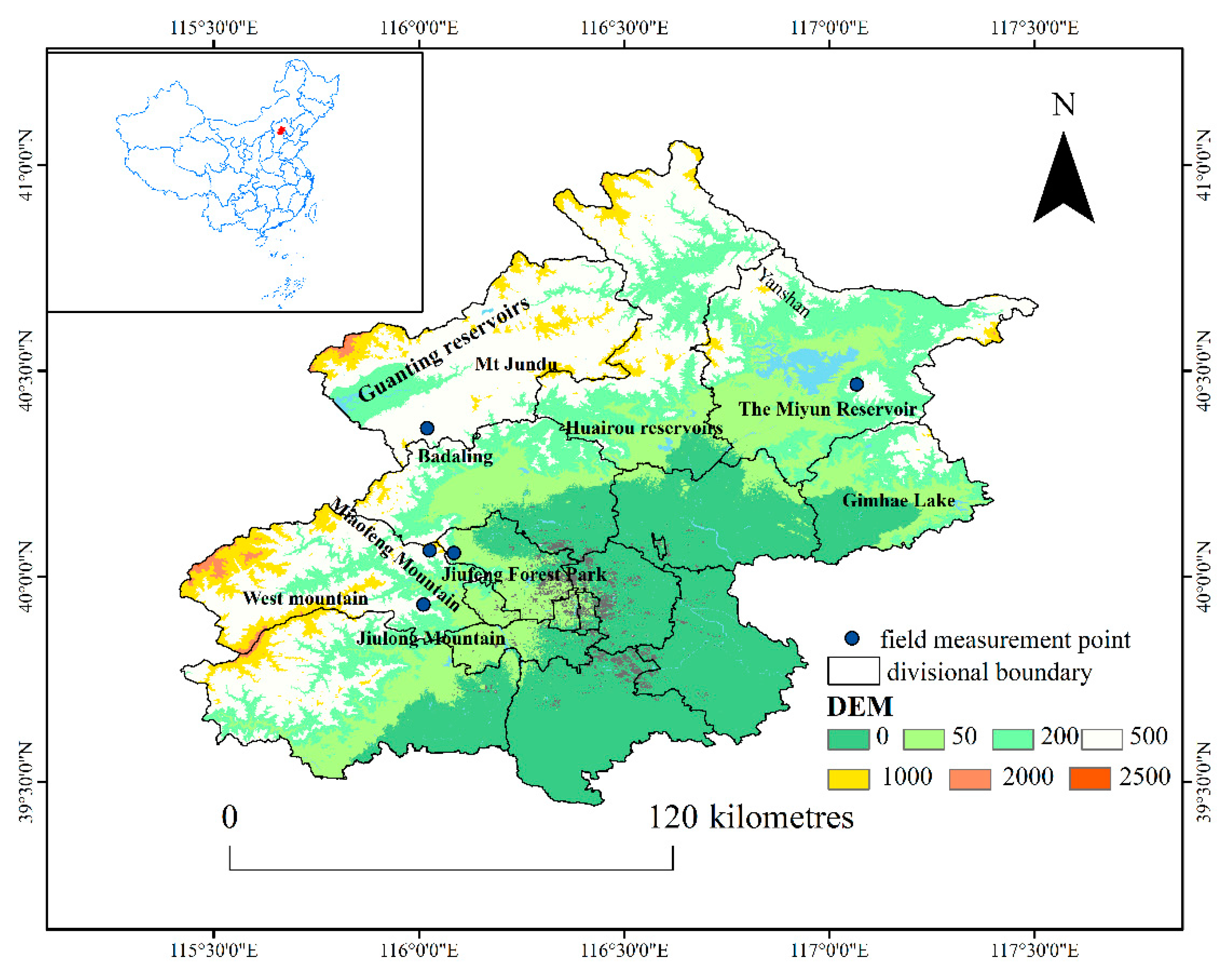
Figure 2.
Schematic diagram of BFAST01 breakpoint type.
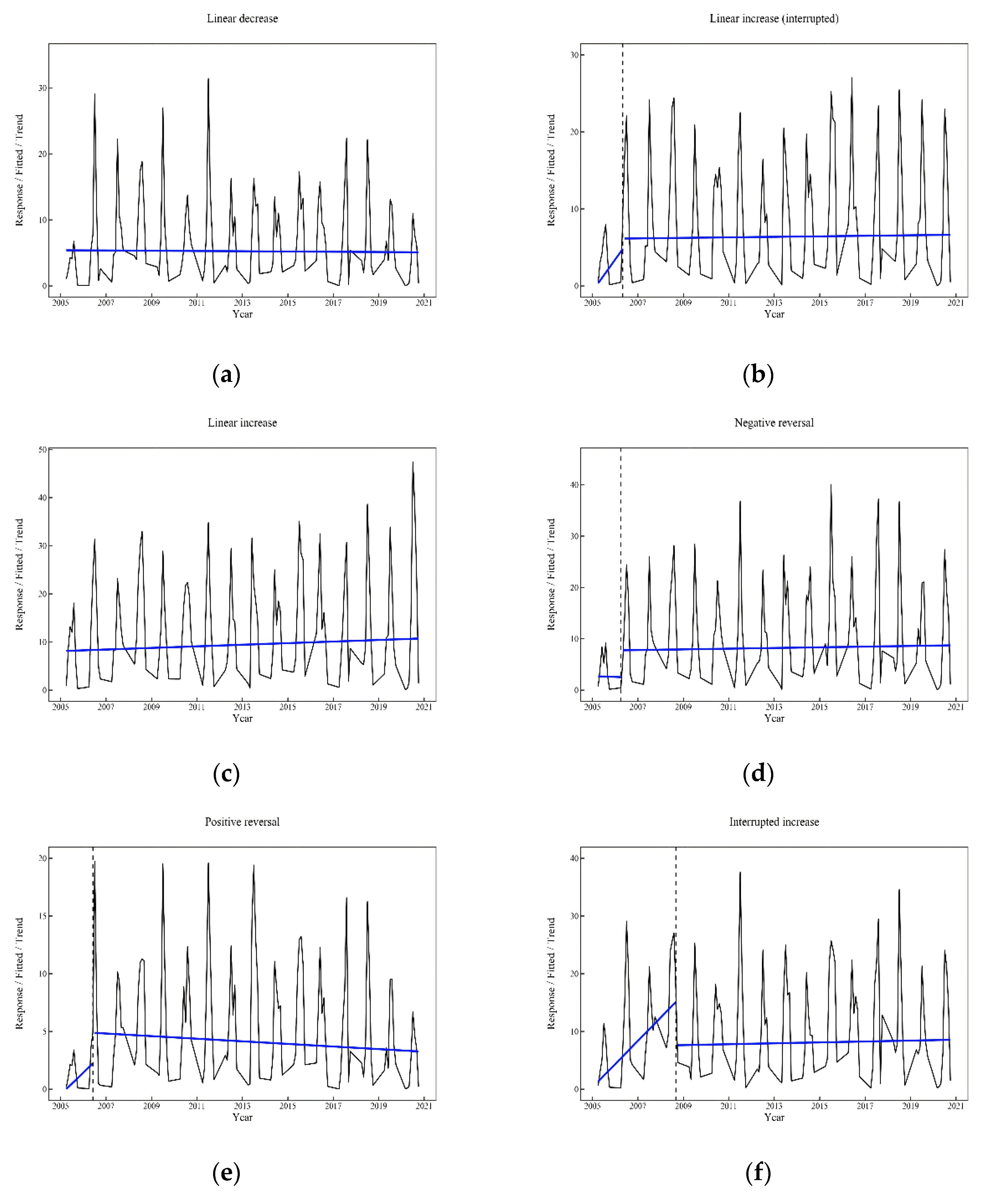
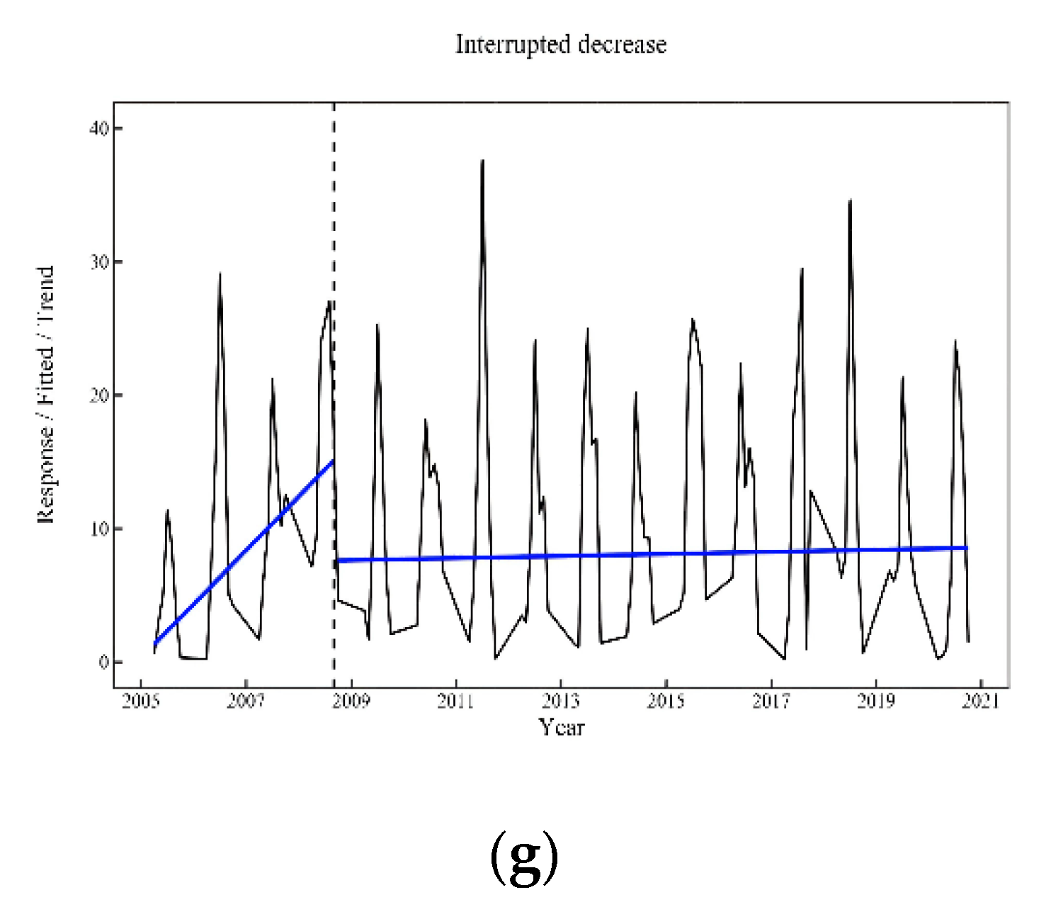
Figure 3.
(a) Comparison of A.P.J. DEROO model simulations with the PML_V2 evaporation dataset; (b) Comparison of A.P.J. DEROO model simulations with measured data.
Figure 3.
(a) Comparison of A.P.J. DEROO model simulations with the PML_V2 evaporation dataset; (b) Comparison of A.P.J. DEROO model simulations with measured data.
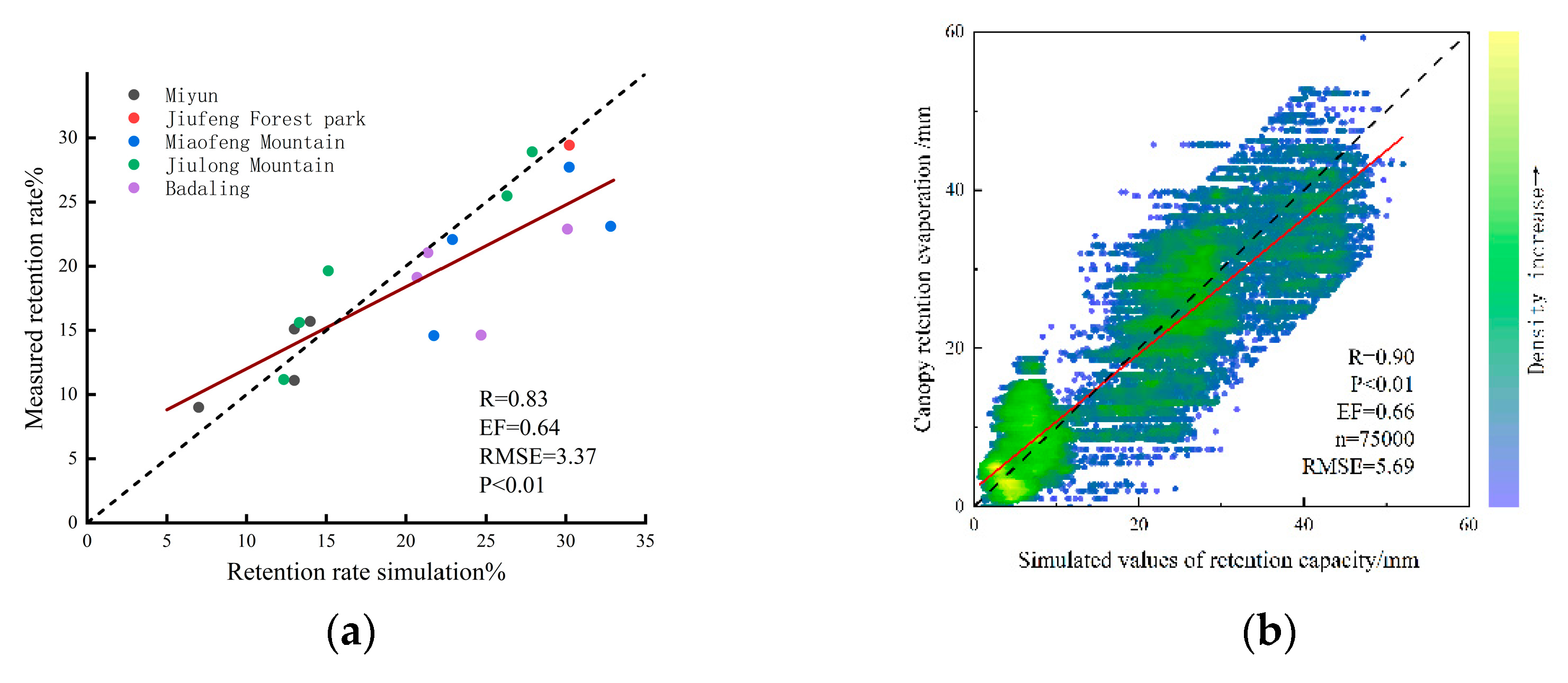
Figure 4.
(a)Trends in the interception of the vegetation canopy in Beijing, 2005-2020; (b) Trends in canopy retention rate, rainfall and leaf area index of vegetation in Beijing, 2005-2020.
Figure 4.
(a)Trends in the interception of the vegetation canopy in Beijing, 2005-2020; (b) Trends in canopy retention rate, rainfall and leaf area index of vegetation in Beijing, 2005-2020.
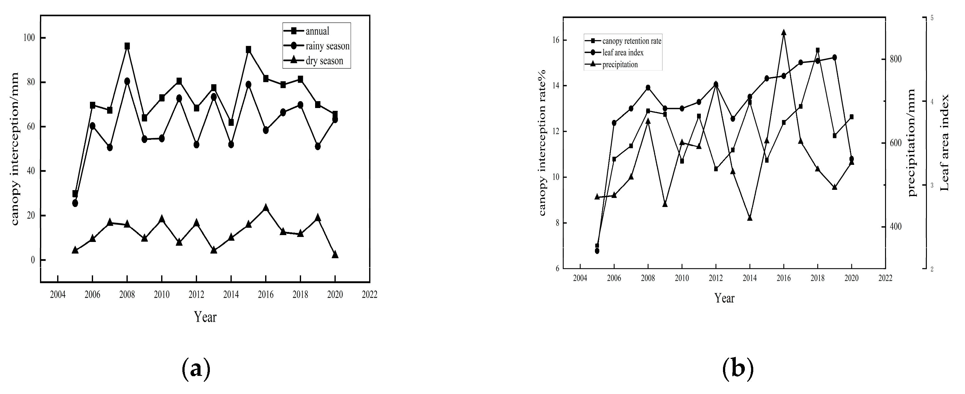
Figure 5.
Spatial and vertical distribution characteristics of interception volume and interception rate from 2005 to 2020.
Figure 5.
Spatial and vertical distribution characteristics of interception volume and interception rate from 2005 to 2020.
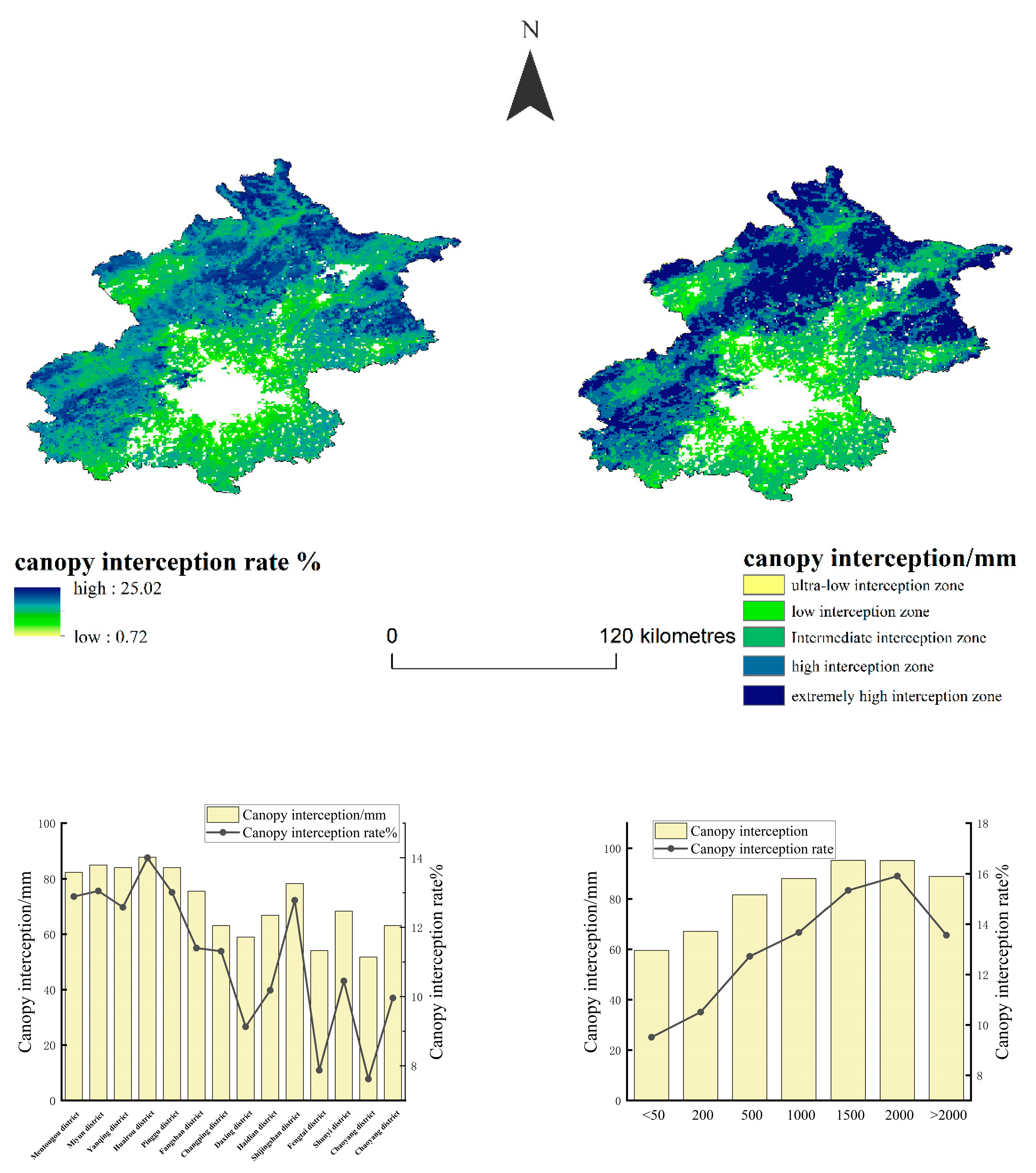
Figure 6.
Trend in canopy interception and distribution of mutation types in Beijing from 2005 to 2020.
Figure 6.
Trend in canopy interception and distribution of mutation types in Beijing from 2005 to 2020.
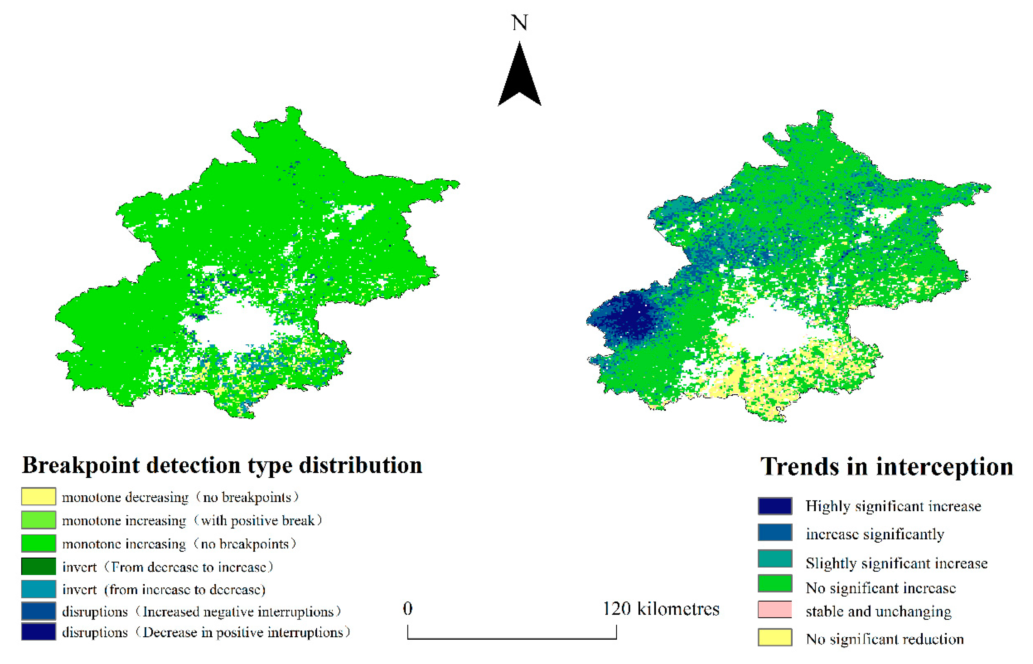
Figure 7.
Single-factor detection of the q value.
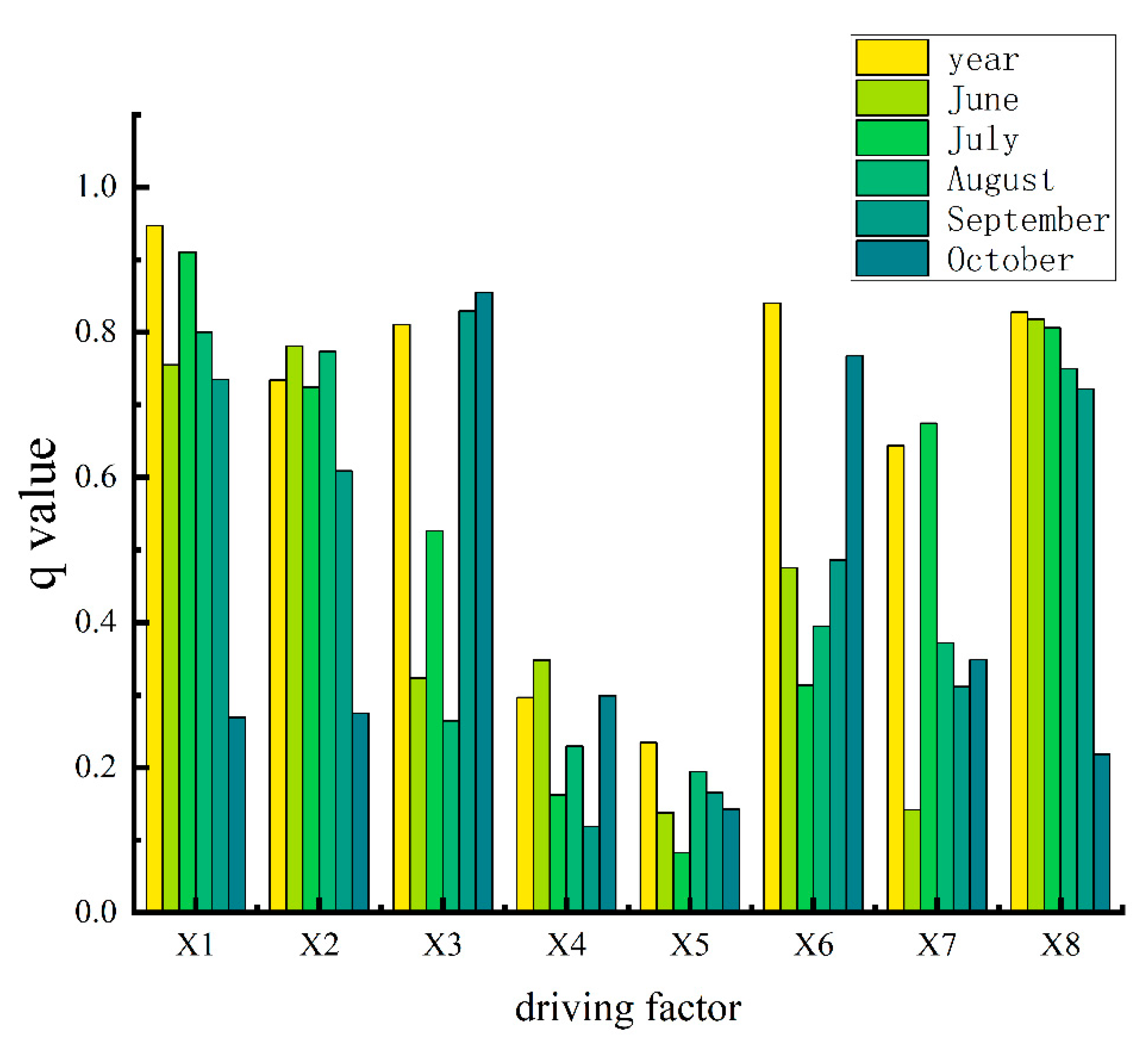

Table 1.
Theil-Sen Median trend analysis and significance statistics.
| Sic | Z-value | Trends in interception | Percentage of area % |
| ≥0.05 | >2.58 | Highly significant increase | 2.9 |
| 1.96<z≤2.58 | increase significantly | 9.1 | |
| 1.65<z≤1.96 | Slightly significant increase | 15.3 | |
| -0.05-0.05 | z≤1.65 | No significant increase | 62.2 |
| <0.05 | z≤1.65 | stable and unchanging | 1.8 |
| z≤1.65 | No significant reduction | 8.7 |
Table 2.
BFAST01 breakpoint type statistics.
| Breakpoint type | pixel count | Percentage of area % |
| monotone decreasing(no breakpoints) | 984 | 2.7 |
| monotone increasing(with positive break) | 3 | 0.01 |
| monotone increasing(no breakpoints) | 33431 | 92.9 |
| invert(From decrease to increase) | 3 | 0.01 |
| invert(go from strength to strength) | 1123 | 3.1 |
| disruptions(Increased negative interruptions) | 435 | 1.2 |
| disruptions(Decrease in positive interruptions) | 11 | 0.03 |
Disclaimer/Publisher’s Note: The statements, opinions and data contained in all publications are solely those of the individual author(s) and contributor(s) and not of MDPI and/or the editor(s). MDPI and/or the editor(s) disclaim responsibility for any injury to people or property resulting from any ideas, methods, instructions or products referred to in the content. |
© 2024 by the authors. Licensee MDPI, Basel, Switzerland. This article is an open access article distributed under the terms and conditions of the Creative Commons Attribution (CC BY) license (http://creativecommons.org/licenses/by/4.0/).
Copyright: This open access article is published under a Creative Commons CC BY 4.0 license, which permit the free download, distribution, and reuse, provided that the author and preprint are cited in any reuse.


