
Submitted:
16 September 2024
Posted:
17 September 2024
You are already at the latest version
Abstract
The conversion of LULC classes into other types is occurring at a faster rate globally including United States. Many studies have examined the drivers and causes of LULC changes, particularly, in northeast Georgia and Atlanta in the United States, while the case of southeast Georgia remains unstudied. Thus, this study filled the gap by quantifying and predicting the impact of LULC change on forestlands and how these LULC changes have affected forest health. The study used Landsat images, including 2005 and 2023 together with the random forest algorithm to perform LULC classification on the Google Earth Engine. Also, the study predicted how LULC will impact forest cover by 2050. The results revealed that forest hectares have generally changed approximately from 65% to 62% between 2005 and 2023, and this is projected to likely further decline to about 53% by 2050. This change in forest acreage has resulted decline in the health of the forest, that is the NDVI values changed from 0.992 to 0.866 between 2005 and 2023. The study concludes that the forest cover in southeast Georgia has changed to urban features over the years. Agriculture land is projected to gain most of the forest cover by 2050.
Keywords:
Sustainable Forest Management
; LULC
; NDVI
; Landsat Satellite
; Google Earth Engine
1. Introduction
A typical approach for depicting the relationship between human activity and the environment is landuse/cover (LULC) change [1,2]. Over the decades, LULC has been rapidly exacerbating across the globe, most especially in developing countries [3,4,5] than in developed countries [6]. Anthropogenic activities are postulated to be the main driving force of LULC change [6,7], and these major activities necessitating the changes are population growth, socio-economic conditions, urbanization, changes in lifestyle, agriculture expansion, increasing energy and wood demand, and economic growth [1,3,8]. The conversion of LULC classes, such as vegetation (forests), land, and water bodies negatively affects biodiversity, conservation, ecosystem services, carbon storage, hydrological processes, and sustainable environment management [2,8,9].
Globally, the forest is an indispensable natural resource to many countries and has been used by millions of people over the decades [10], for instance, communities tend to focus on forests since they are endowed with myriad resources, such as minerals, timber, and food [11,12]. This instance calls for sustainable forest management. The question of how communities can sustainably utilize forest resources to meet their needs without adversely affecting the forest cover has been a major concern of environmental advocates, land-use planners, natural resource managers, and other stakeholders [1,11,12,13,14,15]. Sustainable forest management is the systematic approach employed to ensure both judicious utilization of forests and continuous growth of forests without harming other dependent organisms [12]. Furthermore, sustainable forest management includes environmental benefits, such as ecosystem sustainability, carbon storage and sequestration, improved water and air quality, habitat for endangered species and wildlife, and protects forest health in addition to the social and economic benefits [10,12,16].
Remote sensing data has been broadly utilized in monitoring and assessing environmental changes, such as LULC at the global, regional, and local scales [8,17]. Moreover, under the direction of the LULC change project of the International Geosphere-Biosphere Programme (IGBP) and International Human Dimensions Programme on Global Environmental Change (IHDP), several researchers have improved measurements of land-cover change, the understanding of the causes of landuse change, and predictive models of LULC change over the last few decades [4, 18. 19]. Again, many studies have explored time-series mapping of LULC change globally using multispectral satellite images in fields, such as forestry, agriculture, and natural resources.
Mikeladze et al. [20] used Sentinel-2 multispectral imagery to detect forest cover change in Georgia (the Caucasus). Forest cover estimates were fitted to Sentinel-2A spectral band data that had been altered using various topographic correction techniques using generalized additive models (GAMs). When Sentinel-2 spectral data were topographically adjusted using the Minnaert Correction (R2 = 0.882), the best forest cover metric that could be accounted for was canopy closure, which was computed from upward-looking fisheye pictures obtained beneath the forest canopy. Band 3 (green), Band 8 (NIR), and Band 12 (SWIR) were the spectral bands that best explained canopy closure.
In addition, Housman et al. [21] evaluated forest health insect and disease survey data and satellite-based remote sensing forest change detection methods and assessed them over Southern New England and the Rio Grande National Forest in the US. They compared the performances of the three products employed, namely Insect and Disease Survey (IDS), Modis Real-Time Forest Disturbance (RTFD), and Operational Remote Sensing (ORS) in the analysis. The ORS uses Modis and Landsat data to identify disturbances in the forest. They found that their models performed better in the Southern New England study area, with overall accuracies ranging from 71.63% to 92.55% than in the Rio Grande National Forest area 63.48% to 79.13%. They argued that while many ORS products were as accurate as or more accurate than IDS and RTFD products overall, the differences were not statistically significant at the 95% confidence range. This shows that the data provided by the existing ORS implementation is adequate to supplement IDS data.
Wang et al. [22] explored the use of remote sensing data in analyzing forest health. The results of their review showed that, when cost, bands, temporal and spatial resolutions were taken into account, the majority of the studies concluded that Moderate Resolution Imaging Spectroradiometer satellite data (MODIS) are more suitable than other current satellite data for most remote sensing applications for forest health. However, Landsat images have a better spatial resolution, which aids in detecting smaller changes in the earth’s surface, as well as it is cost-free and can provide historical information than MODIS [23,24].
Furthermore, Vogelmann et al. [25] employed time-series Landsat data to map forest degradation in Lam Dong Province, Vietnam between 1973 and 2014. Based on their results, the province of Lam Dong has seen numerous land-use changes, including slow shifts from forest to non-forest areas. The interfaces between forest and agricultural areas that are quite small and occur closer to the province’s borders are where the most notable recent changes can be seen. A noteworthy finding was that during the Landsat era (1972–present), there has been minimal change in the region’s most heavily protected national reserves.
Kanjin and Alam [9] quantified LULC changes and estimated the Normalized Difference Vegetation Index (NDVI) in Sundarbans (Bangladesh and India) for six different years, such as 1973, 1980, 1990, 2000, 2013, and 2023. The LULC was done using Landsat data, while Modis data was used to calculate the NDVI. According to their findings, over the twenty years in Sundarbans, there have been significant changes in dense and sparse forest. For instance, dense forest has been rapidly converted to sparse indicating that the mangrove vegetation is getting lost due to climate and anthropogenic activities.
Yang and Lo [26] estimated LULC changes using time-series satellite images in the Atlanta, Georgia metropolitan area, US over the past 25 years. They used different methods to map the LULC in the study area, such as radiometric normalization, unsupervised classification, a GIS-based reclassification, and post-classification. The post-classification product was compared with the GIS overlay to detect the LULC changes. The findings reveal the loss of forest and urban sprawl as the main issues associated with Atlanta’s rapid urbanization. Also, Moisen et al. [27] indicated that North Central Georgia has experienced a great deal of forest land and tree cover reduction over the past 30 years. Using remotely sensed observations to supplement standard forest inventory data, their study identified the temporal patterns and thematic shifts associated with this loss.
Despite much research done on LULC changes in the world and most especially in Georgia, US, there is limited knowledge on the extent to which LULC has impacted forest cover and health in Southeast Georgia. Therefore, this study seeks to estimate the impact of LULC on forest cover and forest health in the study area. The study is deemed necessary since the findings will have policy implications on forest management in the study area and also contribute to the body of knowledge on forest cover change estimation. The research specifically addressed four specific questions such as: (1) How much forest cover has been lost from 2005 to 2023? (2) Which LULC class has significantly gained the most area from forest cover over the period? (3) What will be the impact of LULC change on forest cover by 2050? (4) How has LULC change affected forest health between 2005 and 2023?
2. Materials and Methods
2.1. Study Area
The study area is Southeast Georgia in the United States of America (Figure 1). The US has a vast amount of vegetation, with 154 national forests and 20 national grasslands, totaling 193 million acres, under the management of the US Forest Service (USFS) [28]. Georgia, the southern state, is thought to have the most forestland in the US suitable for commercial usage out of all the states [29]. The benefits of Georgia’s forestland to society are numerous and include social, economic, and environmental aspects. In addition to providing timber and forest products, Georgia’s forestlands also store carbon, control erosion and soil formation, pollinate, filter water, provide habitat for wildlife, offer recreational opportunities, and serve an aesthetic, cultural, and passive purpose [29,30]. Southeast Georgia is one of the regions in Georgia that is within a diverse industry base, where manufacturing and agriculture are two of the main economic drivers. This region has 18 counties, with over 431,000 people and it hosts the Okefenokee Swamp [31].
2.2. Data Acquisition and Processing
This study used Landsat 7 and 8 multispectral images, which were obtained in 2005 and 2023. These satellite images were extracted and preprocessed in the Google Earth Engine platform (Figure 2). The pixels of the preprocessed images were then classified into four classes (Table 1) using random forest algorithm. With this, a total of 746 ground truth points was randomly gathered for the LULC classes from Google Earth (high spatial resolution imagery), consisting of 251 samples in 2005 and 495 samples in 2023. The random forest algorithm was used because it is a powerful machine learning classifier that performs well and achieves better accuracy than classical algorithms, such as spectral angle mapper [32]. The random forest algorithm was trained using 60 percent of the ground truth samples for each year. In addition to the random forest model training, the spectral bands incorporated were Blue, Green, Red, Near-Infrared, Shortwave Infrared 1, Shortwave Infrared 2, and NDVI, as well as 1000 decision trees were used.
2.2. Prediction of LULC for 2050
Prediction for 2050 was derived using Modules for Land Use Change Evaluation (MOLUSCE) integrated into QGIS version 2.18 [33]. This software tool employs Cellular Automata and Artificial Neural Network (CA-ANN) methodologies alongside simulations [33,34], which is to anticipate changes in Southeast Georgia classes based on landuse/cover maps from 2005 and 2023. The analytical process primarily involves evaluating correlation (EC), quantifying area alterations, transition potential computation (TPC) modeling, and validation conducted across four (4) iterations. Baseline data for the predictions include a Digital Elevation Model (DEM), and a road raster georeferenced image of Southeast Georgia. Principal predictor variables for future projections encompass elements of the built environment, socio-economic indicators, and natural environmental parameters (Figure 2).
2.3. Accuracy Assessment of LULC Classification
In assessing the accuracy of the classified images for 2005, 2015, and 2023, 40 percent of the ground truth samples for each year were used. The 2050 classified map accuracy was evaluated by using 2000 stratified samples of the LULC change map of 2005 and 2023. The LULC classification accuracy, which is made up of a “confusion matrix” or “error matrix,” was assessed using the producer’s accuracy (PA), user’s accuracy (UA), overall accuracy (OA), and kappa coefficient (K) [8]. The overall accuracy is determined by calculating the user’s accuracy and the producer’s accuracy (Hu et al., 2023). The range of values for Kappa is 0 to 1, with 0 denoting no agreement and 1 denoting total agreement between the two sets of data. When Kappa is less than 0.4, it is deemed poor, between 0.4 and 0.7, it is deemed good, and over 0.75, it is deemed excellent [17,35].
2.4. Post-Classification Change Detection
2.5. Trends of LULC Change Analysis
The LULC change analysis trend offers insights into the temporal extent, trend, and amount of conversions [17]. The pattern of changes in LULC in the study area was analyzed and detected using comparisons of land cover classifications from 2005 to 2023 and 2023 to 2050. The percentage and rate of changes were calculated based on the size of the changes between the two periods. This is expressed as:
where Z is the period interval in years between A2 and A1, A2 is the area of LULC (km2) in period 2, and A1 is the area of LULC (km2) in period 1. This computation was in Google Earth Engine.
2.6. Normalized Difference Vegetation Index (NDVI) Estimation
Normalized difference vegetation Index (NDVI) is the estimation of vegetation health based on how a plant absorbs and reflects light at specific frequencies. Using NDVI is a great method to ascertain the level of vegetative cover and the conditions necessary for vegetative growth [17]. Also, it evaluates vegetation dynamics, tracks change over time and identifies regions of interest for environmental management, land use planning, and conservation [5,36]. This is calculated by the difference between the Near Infrared (NIR) band and the Red band, and it is mathematically expressed in the equation [37].
the value of NDVI ranges from -1 to 1, where values closer to 1 show high vegetation cover or presence/abundance whilst low values represent little or no vegetation cover [5,37]. This index was calculated in Google Earth Engine (Figure 2).
3. Results
3.1. Analysis of LULC Classification
The supervised classification performed showed the LULC Classification map (Figure 3), the accuracy of the LULC classification (Table 2), and the LULC area changes (Figure 4) from 2005 to 2050. The overall accuracy for LULC classification for 2005 and 2023 were 83% and 85%, respectively.
According to Figure 4, forests decreased from 2005 to 2023, and it is expected to decrease by 2050. The agricultural land also decreased between 2005 and 2023, and it is projected to increase by 2050.
In addition, the urban class increased between 2005 and 2023, and it is forecasted to increase by 2050. On the other hand, the water body class increased from 2005 to 2023, and it is expected to decrease by 2050.
3.1.1. Rate of LULC Classes Changes
The LULC classes have undergone various changes across the study period (Table 3). For instance, the forest cover lost was approximately 2.1% between 2005 and 2023, and in 2050, it is estimated to further reduce by 9.78%. The agricultural land lost 3.7% of its acreage during the same period, and this is expected to increase by 2050 by approximately 4.4%.
Regarding Table 4, the rate of change for forest cover decreased by 3.09 hectares (-0.12%) between 2005 and 2023. Similarly, agricultural lands declined by approximately 5.6 hectares (-0.21%) during the same period.
| LULC classes | 2005 | 2023 | Change in 2005 and 2023 | Rate of change | ||
| Hectares | Hectares | Hectares | % | Hectares | % | |
| Urban | 404.54 | 446.29 | 41.75 | 1.54 | 2.32 | 0.09 |
| Forest | 1769.63 | 1713.4 | -55.6 | -2.07 | -3.09 | -0.12 |
| Water bodies | 49.71 | 164.79 | 115.08 | 4.25 | 6.39 | 0.24 |
| Agricultural land | 487.38 | 387.08 | -100.3 | -3.7 | -5.57 | -0.21 |
The rate of LULC acreage changes between 2023 and 2050 (Table 5) revealed that forest cover might lose about 7.6 hectares which is -0.36% over that period. In addition, during the same period, the agricultural lands will likely gain about 5.2 hectares (0.16%).
3.1.2. LULC Classes Change Maps and Detection Statistics
The results from the change detection statistics between 2005 and 2023 are shown in Table 6 and Figure 5 displays the change detection map. Table 6 indicated that forest cover maintained approximately 1417 hectares of its cover over the period, however, it lost about 187 hectares, 111 hectares, and 53 hectares of its size to urban, water bodies, and agricultural lands, respectively. For agricultural lands, it retained approximately 278 hectares of its land size, but classes, such as urban, forest, and water bodies gained 130.58 hectares, 77.12 hectares, and 1.35 hectares, respectively from agricultural land size during the same span-time.
3.2. NDVI Estimation for 2005, 2015, and 2023
4. Discussion
Multispectral satellite imagery, particularly Landsat aids in monitoring environmental changes, such as LULC at a 30-meter resolution [24]. The use of Landsat images for 2005, 2015, and 2023 assisted in estimating LULC changes in Southeast Georgia, US. This study showed that the combination of Landsat imagery and random forest classification algorithm proved to yield a good classification accuracy (83% for 2005 and 85% for 2023), and this supports existing literature [38,39,40].
The LULC classes in the study area have experienced drastic changes across the period. For instance, the forest cover decreased from 65.27% to 63.20% between 2005 and 2023, and this is predicted to decrease to 53.42% by 2050 (Table 3). The change detection statistics (Table 6) presented that the forest cover was mostly lost to the urban class. Also, the 2050 LULC projection showed that agriculture might increase by approximately 18.7%. Because Southeast Georgia is mainly driven by manufacturing and agriculture (Georgia Department of Economic Development, 2024), this could explain the reason for the agricultural expansion by 2050. The studies of Moisen et al. [27] and Yang and Lo [26] also had a relatable finding, which suggested that forest cover in Atlanta and North Central Georgia has declined over the years. Again, Vogelmann et al. [25] findings supported that of this current study, which found that the forests are steadily changing to non-forest areas in Lam Dong Province, Vietnam. Furthermore, Hu et al. [17] unveiled that forest lands in the Southern Punjab Province, Pakistan were converted to urban areas and cropland, which aligned with the results of this study. Moreover, Table 6 shows that forest cover lost about 111 hectares to water bodies. This could partially be the construction of more irrigation facilities to aid agricultural activities and efforts geared towards the restoration of wetlands, like swamps.
According to Figure 8, the NDVI values gradually changed from 0.992 to 0.866 between 2005 and 2023, suggesting that the health of the vegetation cover, such as forest is dwindling in the study area. For instance, Negative NDVI values (-1 to 0) are associated with areas of bare rock, sand, water, urban areas or snow; low values (0 to 0.2) indicate sparse or stressed vegetation, like sparse grassland/shrubland, and areas with low vegetation cover; moderate values (0.3 to 0.5) represent moderate to dense vegetation, namely forest, croplands, and savanna; and high values indicate dense and vigorous vegetation, including dense forests and highly productive agricultural fields [5,17]. This finding corroborates with that of Sarfo et al. [5], who found that the vegetation health in southeastern Ghana had significantly reduced. The reduction of forest health implies carbon sequestration, wildlife-dependent, other ecosystem services, and revenue generation [2,8]. This temporal variation in the NDVI values could partly be due to the annual harvesting of forest products and seasonal variation, such as timbers in the study area.
5. Conclusions
Forest cover provides enormous significance, such as carbon sequestration and ecosystem services to the environment and humans. However, forest cover and health reduction in Southeast Georgia are a threat to the benefits derived from the forest. The use of Landsat images with a random forest classifier made it possible to map and quantify LULC’s influence on forest land and health from 2005 to 2023. The predicted LULC also gives an early warning of how most likely future LULC would be in the study area. The study concludes that forest cover in Southeast Georgia has significantly decreased between 2005 and 2023, with further projections indicating continued decline by 2050. Agriculture, driven by local economic factors, is expected to increase. The analysis of NDVI values supports the finding of declining vegetation health, correlating with reduced forest health and potential ecological impacts. This information is very crucial for landuse planning and management, as well as for sustainable forest management in the study area. This study had a few setbacks concerning some satellite data unavailability. Regardless of these challenges, the study’s findings were not influenced.
Author Contributions
Conceptualization, M.B. and K.K.; methodology, M.B.; software, M.B.; validation, M.B.; formal analysis, M.B and K.K.; resources, M.B. and K.K.; data curation, M.B.; writing—original draft preparation, M.B.; writing—review and editing, K.K.; visualization, M.B.: All authors have read and agreed to the published version of the manuscript.
Funding
This research received no external funding
Data Availability Statement
The study area shapefile and the Google Earth Codes are available with the correspondence author based on request.
Conflicts of Interest
The authors declare no conflicts of interest.
References
- Polasky, S., Nelson, E., Camm, J., Csuti, B., Fackler, P., Lonsdorf, E., Montgomery, C., White, D., Arthur, J., & Garber-Yonts, B. (2008). Where to put things? Spatial land management to sustain biodiversity and economic returns. Biological conservation, 141(6), 1505-1524. [CrossRef]
- Wang, J., Sui, L., Yang, X., Wang, Z., Ge, D., Kang, J., Yang, F., Liu, Y., & Liu, B. (2019). Economic globalization impacts on the ecological environment of inland developing countries: A case study of Laos from the perspective of the land use/cover change. Sustainability, 11(14), 3940. [CrossRef]
- Kusimi, J. M. (2008). Assessing land use and land cover change in the Wassa West District of Ghana using remote sensing. GeoJournal, 71(4), 249-259. [CrossRef]
- Lambin, E. F., Geist, H. J., & Lepers, E. (2003). Dynamics of land-use and land-cover change in tropical regions. Annual review of environment and resources, 28(1), 205-241. [CrossRef]
- Sarfo, I., Bi, S., Kwang, C., Yeboah, E., Addai, F. K., Nkunzimana, A., Ofori, M. A., Batame, M., Appea, E. A., & Asiedu, A. (2023). Class dynamics and relationship between land-use systems and surface temperature in south-eastern Ghana. Environmental Earth Sciences, 82(4), 104. [CrossRef]
- Dewan, A. M., & Yamaguchi, Y. (2009). Land use and land cover change in Greater Dhaka, Bangladesh: Using remote sensing to promote sustainable urbanization. Applied geography, 29(3), 390-401. [CrossRef]
- Wang, L., & Yang, Z.-L. (2020). Changes in land use influenced by anthropogenic activity. In Oxford Research Encyclopedia of Environmental Science. [CrossRef]
- Malede, D. A., Alamirew, T., Kosgie, J. R., & Andualem, T. G. (2023). Analysis of land use/land cover change trends over Birr River Watershed, Abbay Basin, Ethiopia. Environmental and Sustainability Indicators, 17, 100222. [CrossRef]
- Kanjin, K., & Alam, B. M. (2024). Assessing changes in land cover, NDVI, and LST in the Sundarbans mangrove forest in Bangladesh and India: A GIS and remote sensing approach. Remote Sensing Applications Society and Environment, 36, 101289. [CrossRef]
- Gutierrez Garzon, A. R., Bettinger, P., Siry, J., Mei, B., & Abrams, J. (2020). The terms foresters and planners in the United States use to infer sustainability in forest management plans: A survey analysis. Sustainability, 12(1), 17. [CrossRef]
- Bardsley, D. K., Cedamon, E., Paudel, N., & Nuberg, I. (2024). Forest livelihood values and management opportunities to support the agrarian transition in Nepal. Journal of Rural Studies, 107, 103253. [CrossRef]
- Kumar, M., Phukon, S. N., & Singh, H. (2021). The role of communities in sustainable land and forest management. In Forest resources resilience and conflicts (pp. 305-318). Elsevier. [CrossRef]
- Briassoulis, H. (2009). Factors influencing land-use and land-cover change. Land cover, land use and the global change, encyclopaedia of life support systems (EOLSS), 1, 126-146.
- Corbera, E., Estrada, M., May, P., Navarro, G., & Pacheco, P. (2011). Rights to land, forests and carbon in REDD+: insights from Mexico, Brazil and Costa Rica. Forests, 2(1), 301-342. [CrossRef]
- Haji, L., Valizadeh, N., & Hayati, D. (2020). The role of local communities in sustainable land and forest management. In Spatial Modeling in Forest Resources Management: Rural Livelihood and Sustainable Development (pp. 473-503). Springer. [CrossRef]
- Patel, R., Mukherjee, S., Sahu, B., Dash, B., Jaison, M., Avinash, K., & Singh, P. (2024). Sustainable Forest Management (SFM) for C Footprint and Climate Change Mitigation. In Agroforestry to Combat Global Challenges: Current Prospects and Future Challenges (pp. 203-217). Springer. [CrossRef]
- Hu, Y., Raza, A., Syed, N. R., Acharki, S., Ray, R. L., Hussain, S., Dehghanisanij, H., Zubair, M., & Elbeltagi, A. (2023). Land use/land cover change detection and NDVI estimation in Pakistan’s Southern Punjab Province. Sustainability, 15(4), 3572. [CrossRef]
- Lambin, E. F. (1999). Land-use and land-cover Change (LUCC)-implementation strategy. A core project of the international geosphere-biosphere programme and the international human dimensions programme on global environmental change.
- Turner, B. L., Skole, D., Sanderson, S., Fischer, G., Fresco, L., & Leemans, R. (1995). Land-use and land-cover change: science/research plan. [No source information available].
- Mikeladze, G., Gavashelishvili, A., Akobia, I., & Metreveli, V. (2020). Estimation of forest cover change using Sentinel-2 multi-spectral imagery in Georgia (the Caucasus). iForest-Biogeosciences and Forestry, 13(4), 329. [CrossRef]
- Housman, I. W., Chastain, R. A., & Finco, M. V. (2018). An evaluation of forest health insect and disease survey data and satellite-based remote sensing forest change detection methods: Case studies in the United States. Remote Sensing, 10(8), 1184. [CrossRef]
- Wang, J., Sammis, T. W., Gutschick, V. P., Gebremichael, M., Dennis, S. O., & Harrison, R. E. (2010). Review of satellite remote sensing use in forest health studies. The Open Geography Journal, 3(1). [CrossRef]
- Wu, G., De Leeuw, J., Skidmore, A. K., Prins, H. H., & Liu, Y. (2008). Comparison of MODIS and Landsat TM5 images for mapping tempo–spatial dynamics of Secchi disk depths in Poyang Lake National Nature Reserve, China. International Journal of Remote Sensing, 29(8), 2183-2198. [CrossRef]
- Wulder, M., & Loveland, T. (2019). Roy, DP Crawford, CJ Masek, JG Woodcock, CE Allen, RG Anderson, MC Belward, AS Cohen, WB Dwyer, J. Erb, A. Gao, F. et al. Current status of Landsat program, science, and applications. Remote Sensing of Environment, 225, 127-147.
- Vogelmann, J. E., Khoa, P. V., Lan, D. X., Shermeyer, J., Shi, H., Wimberly, M. C., Duong, H. T., & Huong, L. V. (2017). Assessment of forest degradation in Vietnam using Landsat time series data. Forests, 8(7), 238. [CrossRef]
- Yang, X., & Lo, C. (2002). Using a time series of satellite imagery to detect land use and land cover changes in the Atlanta, Georgia metropolitan area. International Journal of Remote Sensing, 23(9), 1775-1798. [CrossRef]
- Moisen, G. G., McConville, K. S., Schroeder, T. A., Healey, S. P., Finco, M. V., & Frescino, T. S. (2020). Estimating land use and land cover change in North Central Georgia: Can remote sensing observations augment traditional forest inventory data? Forests, 11(8), 856. [CrossRef]
- Forest Service U.S. Department of Agriculture. (2013). By the Numbers. Retrieved 20/03/2024 from https://www.fs.usda.gov/about-agency/newsroom/by-the-numbers.
- Berget, C., & Dwivedi, P. (2024). Do female and male family forest landowners think alike? A qualitative analysis from Georgia, United States. Trees, Forests and People, 100540. [CrossRef]
- Moore, R., Williams, T., Rodriguez, E., & Hepinstall-Cymerman, J. (2013). Using nonmarket valuation to target conservation payments: An example involving Georgia’s private forests. Journal of Forestry, 111(4), 261-270. [CrossRef]
- Georgia Department of Economic Development. (2024). Southeast Georgia - Region 11. Retrieved 21/03/2024 from https://www.georgia.org/regions/southeast-georgia.
- Breiman, L. (2001). Random forests. Machine learning, 45, 5-32. [CrossRef]
- Kamaraj, M., & Rangarajan, S. (2022). Predicting the future land use and land cover changes for Bhavani basin, Tamil Nadu, India, using QGIS MOLUSCE plugin. Environmental Science and Pollution Research, 29(57), 86337-86348. [CrossRef]
- Muhammad, R., Zhang, W., Abbas, Z., Guo, F., & Gwiazdzinski, L. (2022). Spatiotemporal change analysis and prediction of future land use and land cover changes using QGIS MOLUSCE plugin and remote sensing big data: a case study of Linyi, China. Land, 11(3), 419. [CrossRef]
- Ismail, M. H., & Jusoff, K. (2008). Satellite data classification accuracy assessment based from reference dataset. International Journal of Geological and Environmental Engineering, 2(3), 23-29.
- Meneses-Tovar, C. (2011). NDVI as indicator of degradation. Unasylva, 62(238), 39-46.
- Morshed, S. R. M. R., Fattah, M. A., Rimi, A. A., & Haque, M. N. (2020). Surface temperature dynamics in response to land cover transformation. Journal of Civil Engineering, Science and Technology, 11(2), 94-110.
- Ajagun, E. O., Ashiagbor, G., Asante, W. A., Gyampoh, B. A., Obirikorang, K. A., & Acheampong, E. (2021). Cocoa eats the food: expansion of cocoa into food croplands in the Juabeso District, Ghana. Food Security, 1-20. [CrossRef]
- Amini, S., Saber, M., Rabiei-Dastjerdi, H., & Homayouni, S. (2022). Urban land use and land cover change analysis using random forest classification of landsat time series. Remote Sensing, 14(11), 2654. [CrossRef]
- Junaid, M., Sun, J., Iqbal, A., Sohail, M., Zafar, S., & Khan, A. (2023). Mapping lulc dynamics and its potential implication on forest cover in malam jabba region with landsat time series imagery and random forest classification. Sustainability, 15(3), 1858. [CrossRef]
Figure 1.
Map of Southeast Georgia, US.
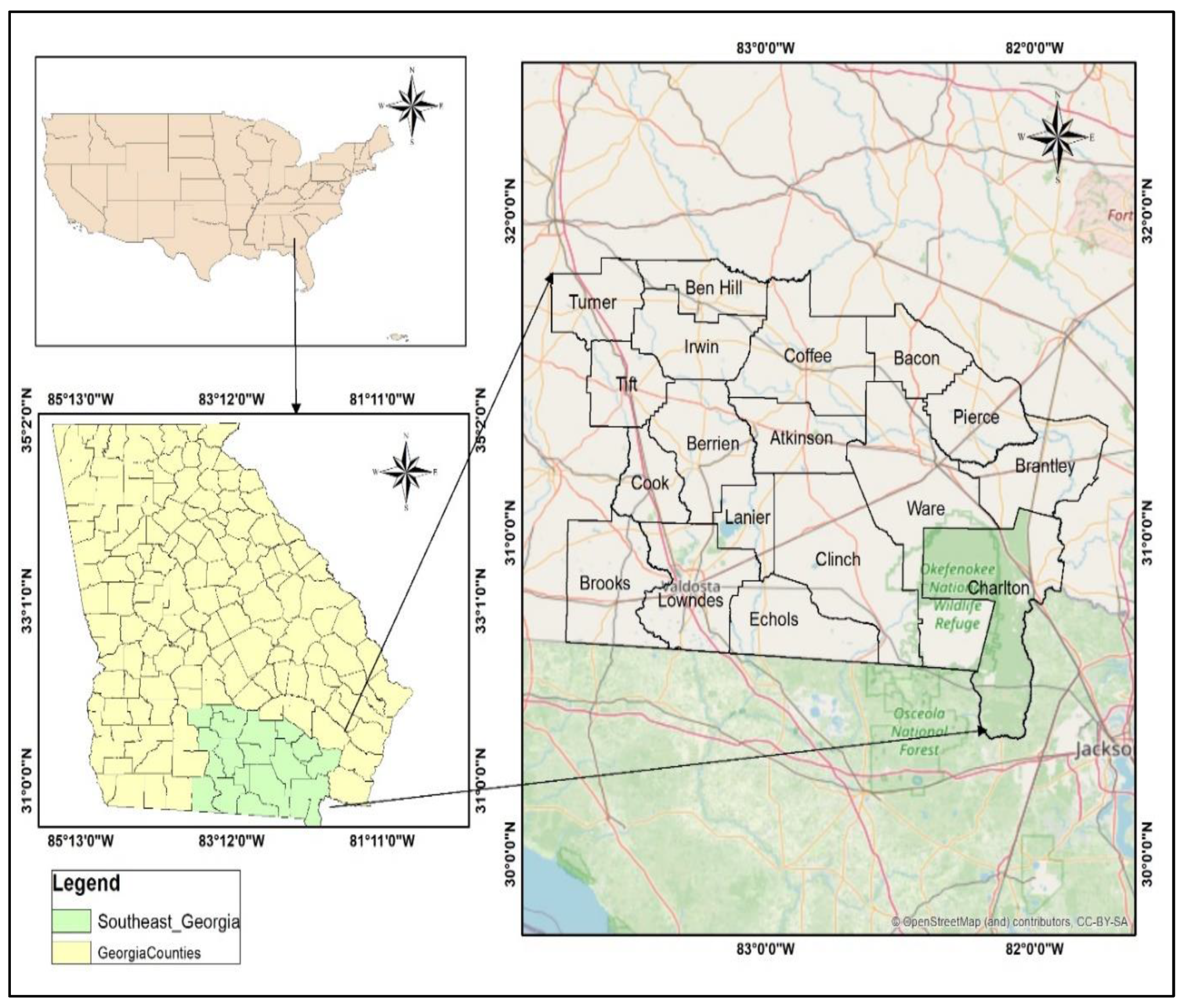
Figure 2.
Flowchart of the methodology for this study.
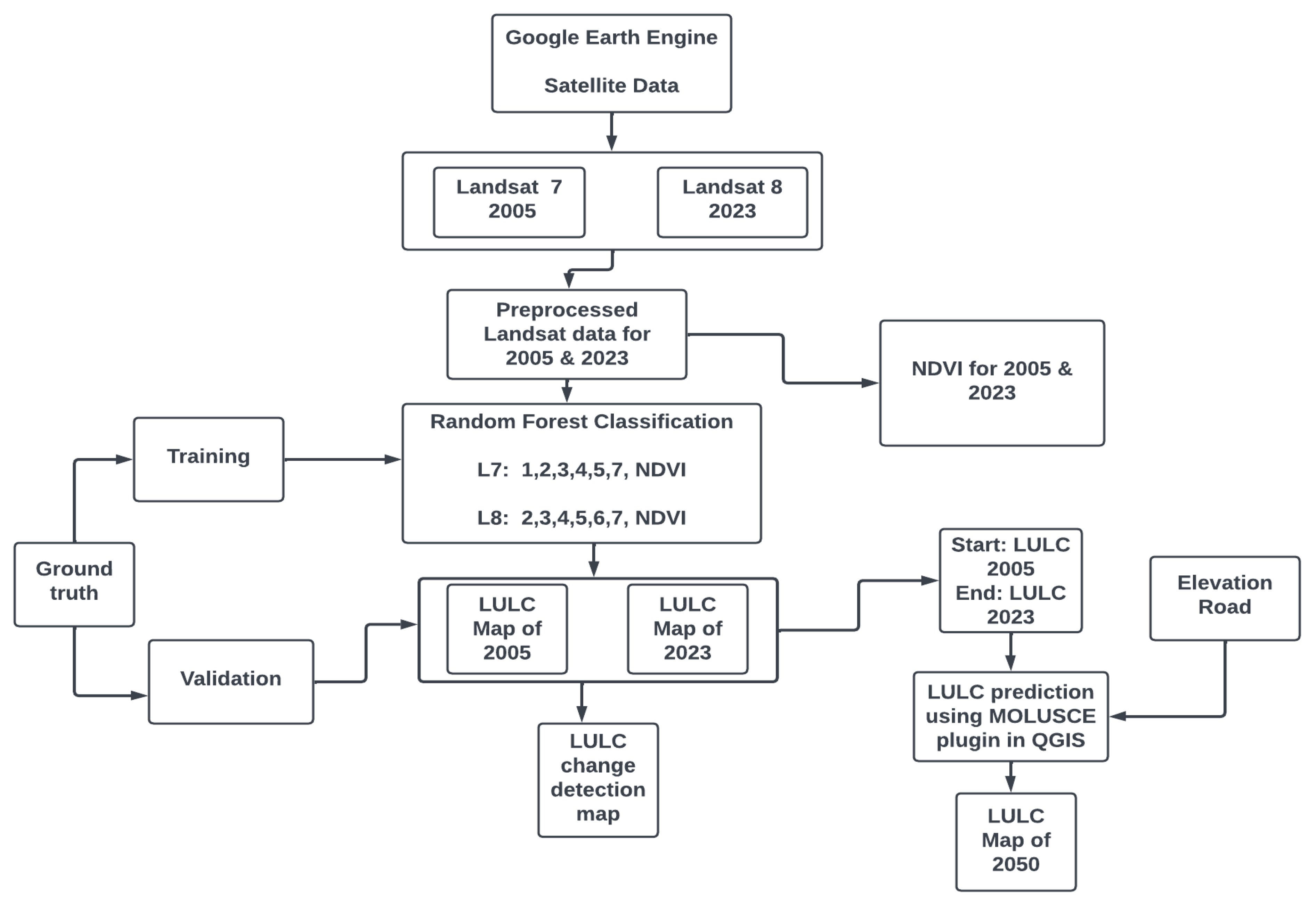
Figure 3.
LULC classification for 2005, 2015, 2023, and 2050.
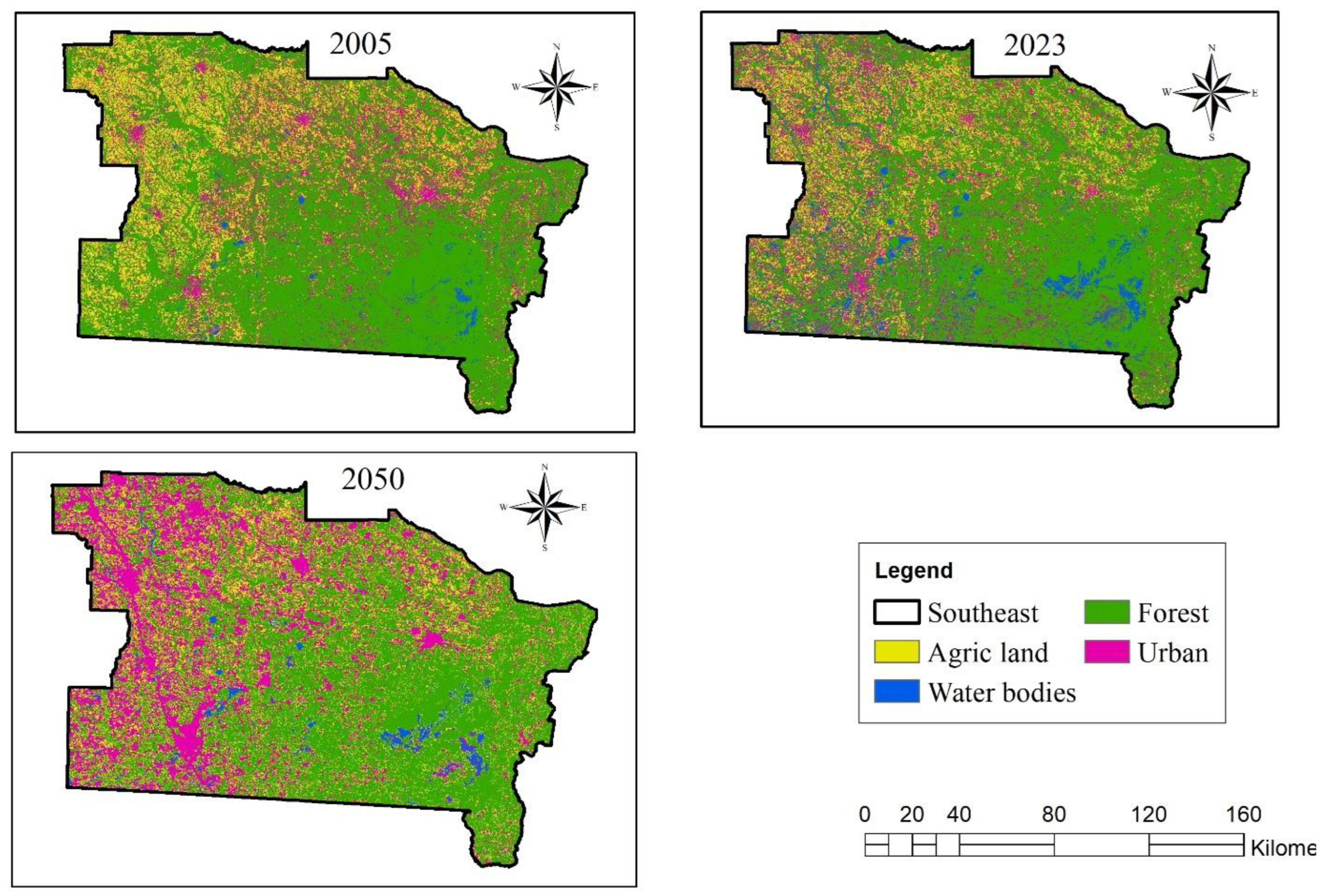
Figure 4.
Changes in the LULC acreage from 2005 to 2050 in hectares.
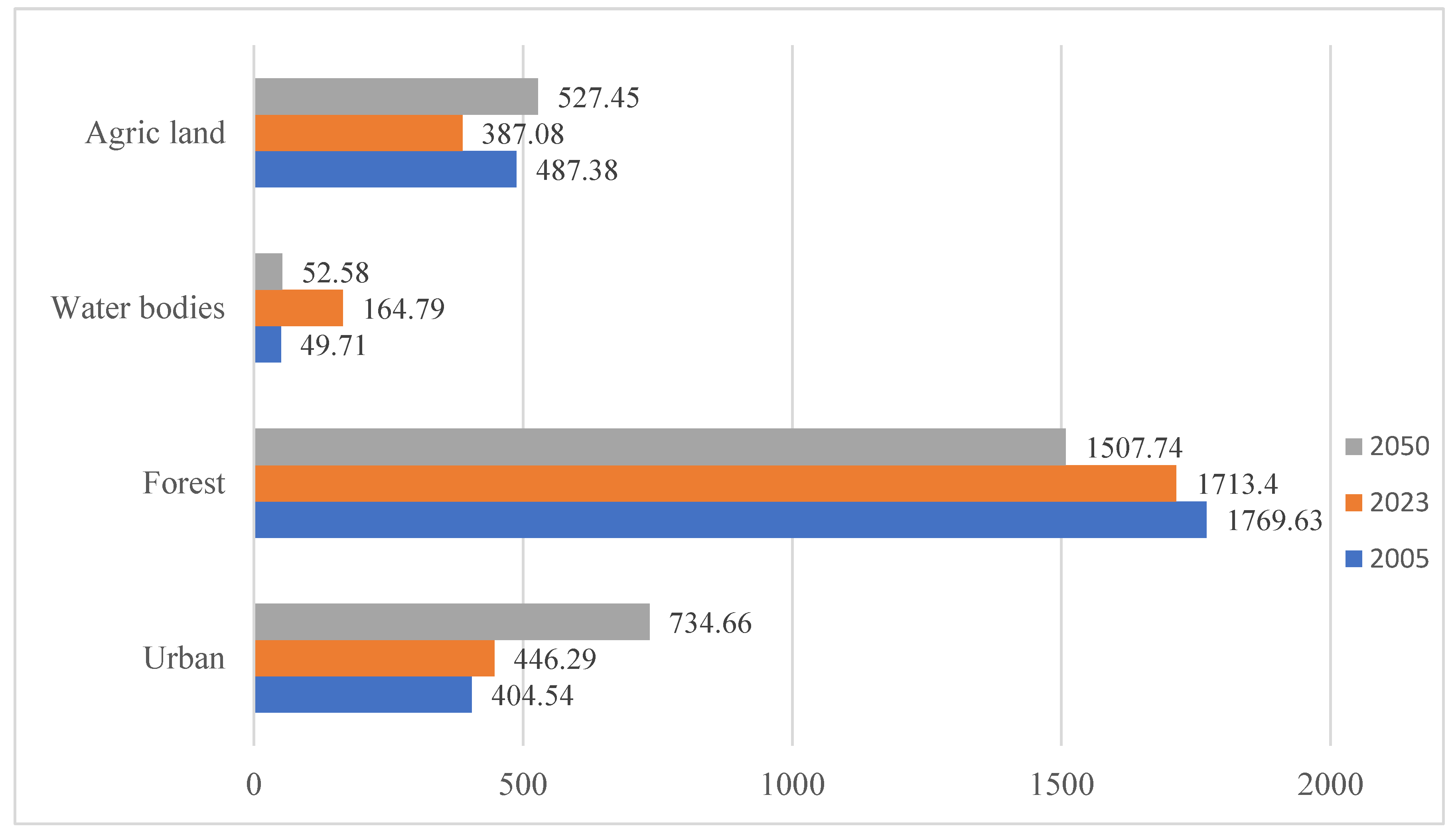
Figure 5.
LULC change detection map between 2005 and 2023.
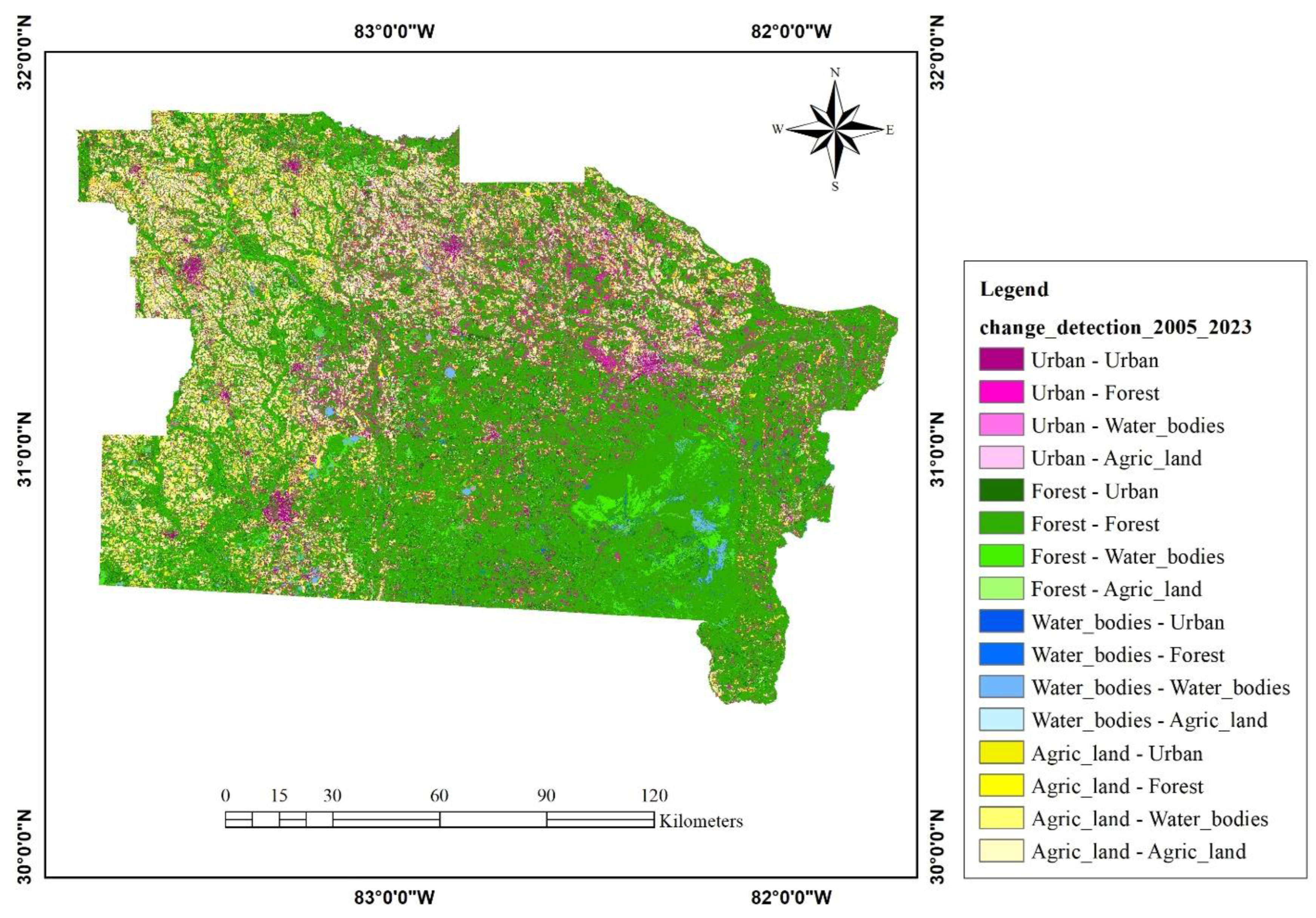
Figure 6.
A map of NDVI changes from 2005 to 2023.
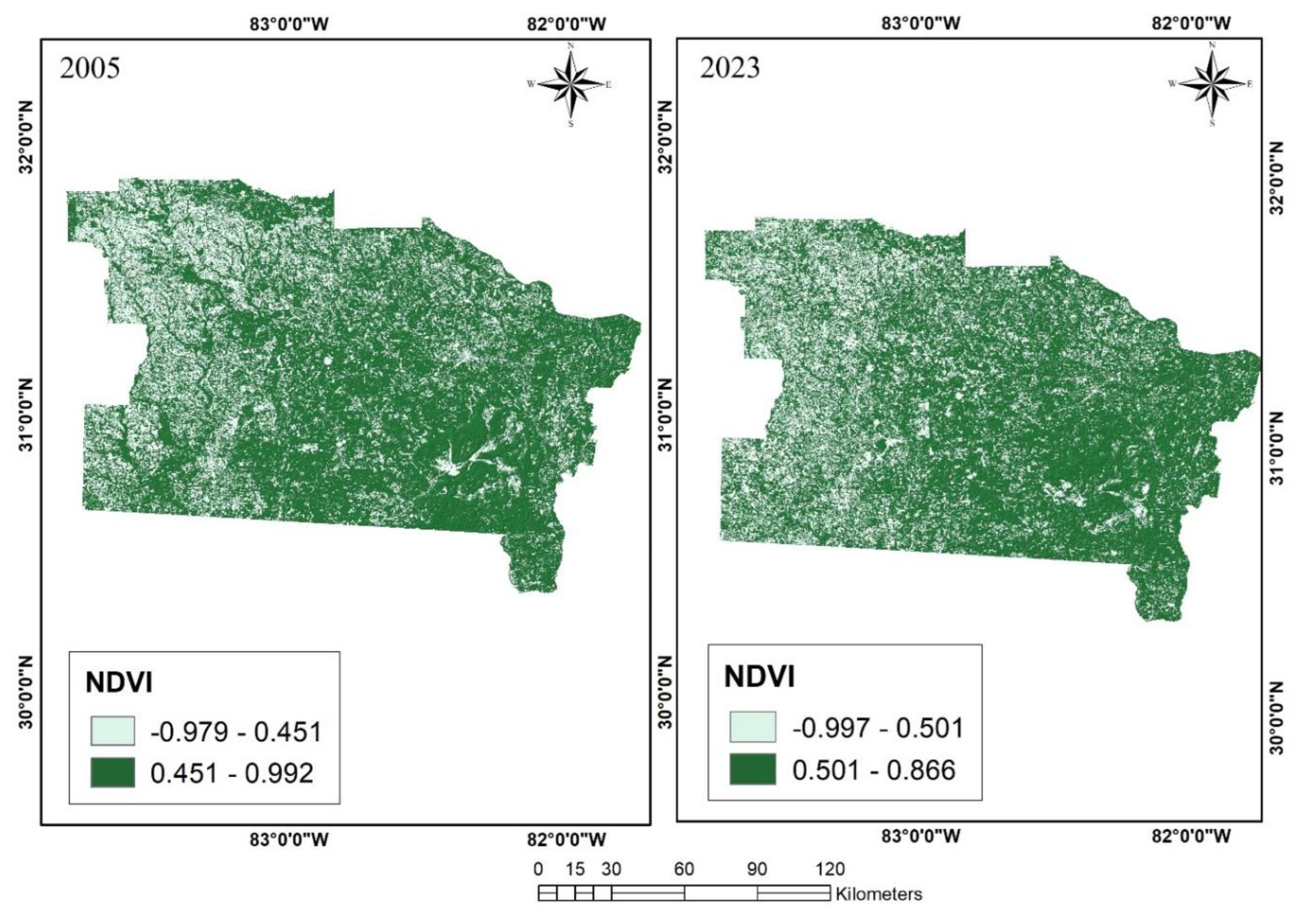
Figure 7.
Temporal variation of NDVI values.
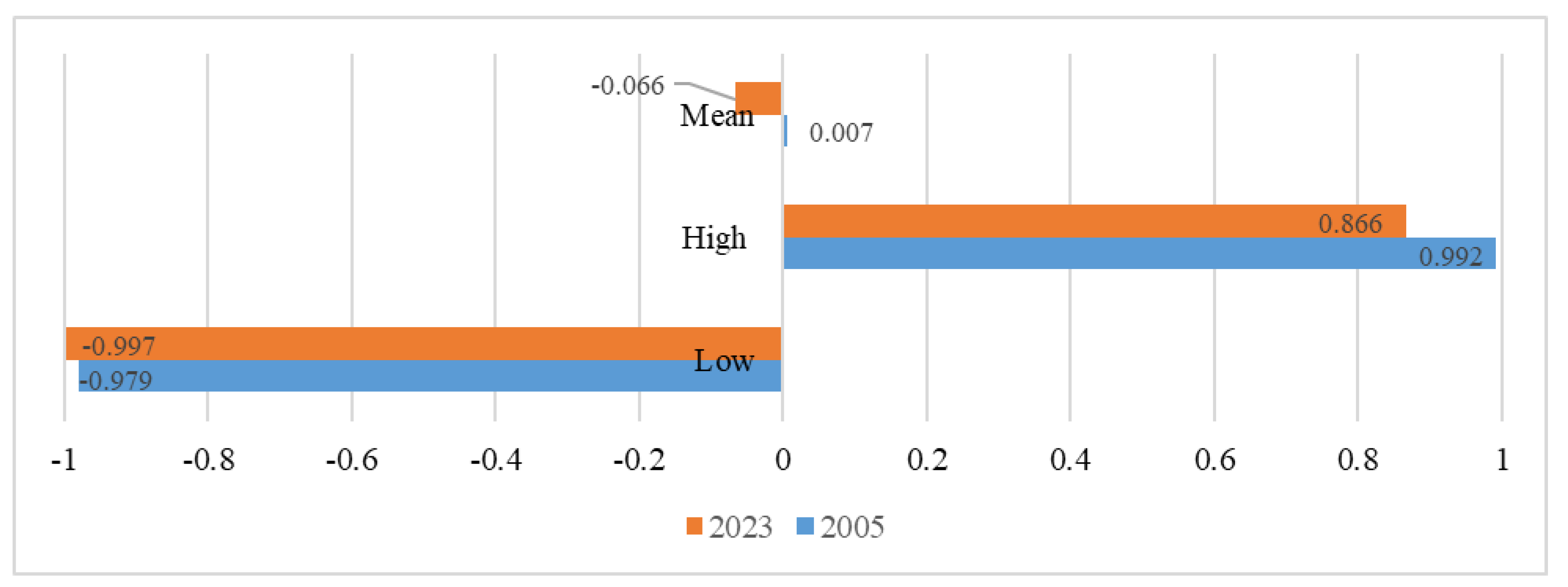

Table 1.
LULC class description.
| LULC Class | Description |
|---|---|
| Urban: | Human-induced features: included settlement, roads, areas under construction, bare land, pathways, etc. |
| Forest: | All forms of vegetation, particularly, trees, plantations, etc. |
| Water bodies: | Rivers, ponds, streams, etc. |
| Agricultural land: | Included all lands reserved for farming, such as harvested lands, land under cultivation, etc. |
Table 2.
LULC classification accuracy assessment.
| LULC Classes | 2005 | 2023 | ||
|---|---|---|---|---|
| Producer Accuracy | User Accuracy | Producer Accuracy | User Accuracy | |
| Urban | 0.70 | 0.69 | 0.74 | 0.71 |
| Forest | 0.88 | 0.97 | 0.94 | 0.92 |
| Water bodies | 0.89 | 0.88 | 0.91 | 0.94 |
| Agricultural land | 0.87 | 0.76 | 0.79 | 0.81 |
| Overall Accuracy | 0.83 | 0.85 | ||
| Kappa | 0.75 | 0.80 | ||
Table 3.
Percentage acreage changes from 2005 to 2050.
| LULC classes | Percentage changes in acreages | ||||
|---|---|---|---|---|---|
| 2005 | 2023 | 2050 | 2023 – 2005 | 2050 -2023 | |
| Urban | 14.92 | 16.46 | 26.03 | 1.54 | 9.57 |
| Forest | 65.27 | 63.20 | 53.42 | -2.07 | -9.78 |
| Water bodies | 1.83 | 6.08 | 1.86 | 4.25 | -4.22 |
| Agricultural land | 17.98 | 14.28 | 18.69 | -3.7 | 4.41 |
Table 5.
Rate of LULC changes between 2023 and 2050.
| LULC classes | 2023 | 2050 | Change in 2023 and 2050 | Rate of change | ||
|---|---|---|---|---|---|---|
| Hectares | Hectares | Hectares | % | Hectares | % | |
| Urban | 446.29 | 734.66 | 288.37 | 9.57 | 10.68 | 0.35 |
| Forest | 1713.4 | 1507.74 | -205.66 | -9.78 | -7.62 | -0.36 |
| Water bodies | 164.79 | 52.58 | -112.21 | -4.22% | -4.16 | -0.16 |
| Agricultural land | 387.08 | 527.45 | 140.37 | 4.41% | 5.20 | 0.16 |
Table 6.
LULC change detection statistics between 2005 and 2023.
| Change (2023-2005) | Area in Hectares |
|---|---|
| Urban - Urban | 126.11 |
| Urban - Forest | 206.55 |
| Urban - Water bodies | 15.71 |
| Urban - Agricultural land | 55.90 |
| Forest - Urban | 187.33 |
| Forest - Forest | 1417.24 |
| Forest – Water bodies | 111.40 |
| Forest – Agricultural land | 52.66 |
| Water bodies - Urban | 1.96 |
| Water bodies - Forest | 11.41 |
| Water bodies – Water bodies | 35.92 |
| Water bodies – Agricultural land | 0.17 |
| Agricultural land - Urban | 130.58 |
| Agricultural land - Forest | 77.12 |
| Agricultural land – Water bodies | 1.35 |
| Agricultural land - Agricultural land | 278.19 |
Disclaimer/Publisher’s Note: The statements, opinions and data contained in all publications are solely those of the individual author(s) and contributor(s) and not of MDPI and/or the editor(s). MDPI and/or the editor(s) disclaim responsibility for any injury to people or property resulting from any ideas, methods, instructions or products referred to in the content. |
© 2024 by the authors. Licensee MDPI, Basel, Switzerland. This article is an open access article distributed under the terms and conditions of the Creative Commons Attribution (CC BY) license (http://creativecommons.org/licenses/by/4.0/).
Copyright: This open access article is published under a Creative Commons CC BY 4.0 license, which permit the free download, distribution, and reuse, provided that the author and preprint are cited in any reuse.


