
Submitted:
29 August 2024
Posted:
02 September 2024
You are already at the latest version
Abstract
The object of this research project is the investigation of the forgotten landscape of transhumance in mainland Greece, focusing on areas abandoned by modern society and their historical passage. The objective is to revive these lands by restoring their cultural heritage and creating a sustainable community that balances the needs of people, livestock, and the environment. The investigation employs a dual approach: studying transhumance as a cultural and natural practice and analyzing anonymous architecture to preserve collective memory. This involves extensive historical research and a simultaneous analysis of spatial, social, symbolic, and architectural elements. The study identifies convergence points between cultural practices and architectural heritage, applying these insights to modern redevelopment scenarios. Findings reveal a significant interplay between transhumance practices and the region’s anonymous architecture. Key characteristics of the landscape and its spatial identity are documented, providing insights into effective preservation and redevelopment strategies. Specific case studies validate these strategies, demonstrating their relevance to current and future efforts. The study concludes that understanding the historical context and spatial identity of transhumance landscapes is crucial for sustainable redevelopment. By preserving cultural practices and architectural heritage, this project offers a framework for revitalizing these forgotten landscapes, ensuring balanced coexistence of people, livestock, and the environment.
Keywords:
Transhumance
; Anonymous architecture
; Local Identity
; Biodiversity
; Mainland Greece
1. Introduction
Transhumance, the seasonal movement of people and their livestock between geographical or climatic regions, is a practice with deep historical roots and significant cultural, environmental, and socio-economic implications. Annually, herders orchestrate the movement of thousands of animals along traditional pastoral routes, migrating to higher pastures in the summer and descending to lower valleys in the winter. While "transhumance" generally refers to this seasonal journey, it is occasionally used to describe nomadic pastoralism, which involves longer-distance migrations of both people and livestock.
Understanding transhumance is crucial as it intertwines with various aspects of human and environmental systems. According to Evans [1], transhumance and nomadism, although similar, diverge in their cultural settings and social structures. Transhumance involves regular seasonal and altitudinal movements to and from a permanent settlement, whereas nomadic movements are less predictable and do not rely on a fixed base [1].
From an environmental perspective, transhumance plays a vital role in landscape shaping, forest fire prevention, and the creation of ecological corridors. This practice significantly contributes to biodiversity preservation and climate change mitigation through sustainable resource management [2]. Socio-culturally, transhumance fosters the development of cultural identities, strengthens inter-community bonds, and supports rural economies by providing high-quality products such as cheese, meat, wool, and leather [3]. This economic benefit is particularly important for addressing the issue of rural depopulation [4].
In recognition of its importance, UNESCO declared transhumance an "Intangible Cultural Heritage" in 2019, and on December 5th, 2023, it was officially designated an Intangible Cultural Heritage of Humanity at the 18th session of the Intergovernmental Committee for the Safeguarding of the Intangible Cultural Heritage in Botswana [5]. This recognition highlights the practice’s role in preserving environmental knowledge and cultural traditions.
In Greece, transhumance is deeply rooted in the country’s rugged landscape and historical context. The geomorphology and the traditional production system in lowland areas facilitated the evolution of transhumance stock farming [6]. Greece’s diverse topographical features, including expansive plains, fertile valleys, and mountainous regions, are integral to this practice. These areas offer crucial grazing lands and cooler temperatures in the summer, while rivers contribute to the ecological balance and fertility of the landscape [7].
The Greek countryside presents an environment where the distinction between "inside" and "outside" spaces harmoniously merges, reflecting a unique spatial organization [8]. The architecture and practices associated with transhumance are influenced by climatic, social, economic, and cultural factors. This phenomenon creates a distinct identity for the landscape, intertwining human and natural elements [9]. The Mediterranean tradition of mountain nomadism is evident in Greece, characterized by a Mediterranean climate in high mountain regions and landscapes shaped by mobile goat and sheep husbandry [10].
The Greek pastoral landscapes can be categorized into three main zones:
(a) the area surrounding settlements up to the forest edges,
(b) the high-altitude summer pastures, and
(c) the routes connecting these zones used for herding and transportation [11].
These landscapes, defined by the European Landscape Convention as portions of an area perceived through the interaction of natural and human elements [12], are rich in cultural heritage and feature pathways, bridges, monasteries, and other historical elements.
Despite their enduring significance, transhumance routes face challenges related to abandonment and modification. The ecological and cultural values of these routes are significant, yet they are threatened by socio-economic and political influences [13]. Research highlights the critical role of transhumance in maintaining biodiversity and landscape structure [14]. However, there is growing concern about the impacts of modern practices and abandonment on traditional systems [15].
The principal aim of this work is to explore the multifaceted impacts of transhumance on landscapes, biodiversity, and cultural heritage in Greece. The study underscores the importance of preserving transhumance systems for their ecological and cultural benefits and highlights the need for further research to understand and mitigate the effects of socio-economic changes on these traditional practices [13,16].
2. Materials and Methods
2.1. Study Area
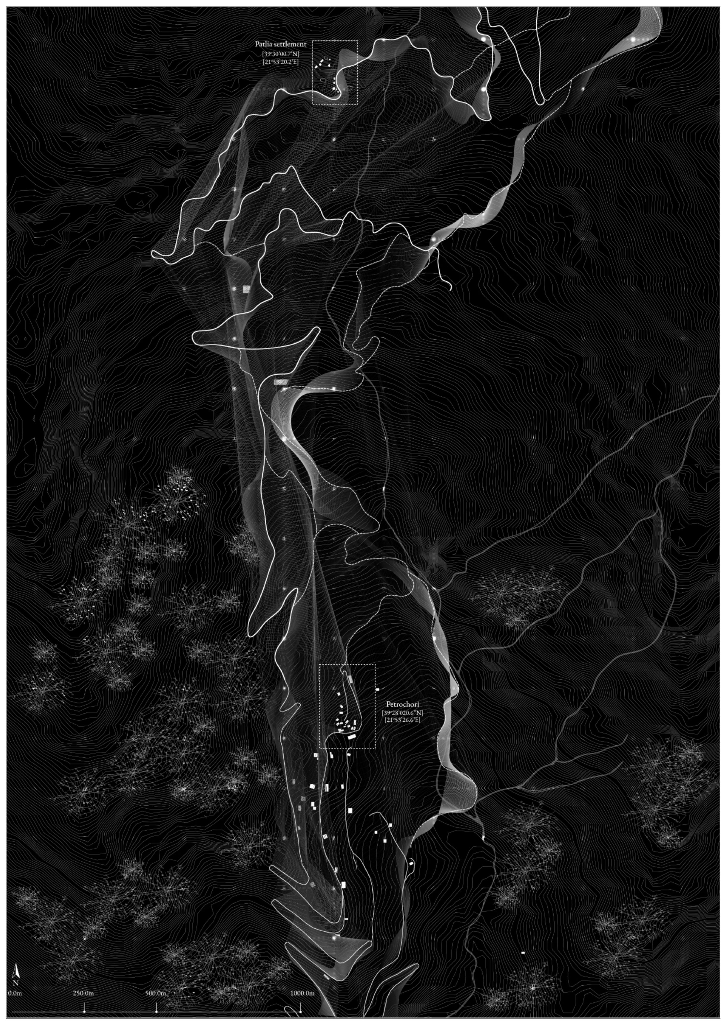
Patlia, a traditional settlement located in the Thessaly Region of Greece, serves as the focal point of this study due to its unique characteristics and historical context of transhumance. Nestled amidst the rolling hills of Thessaly, next to Petrochori village, Patlia is perched on a cliff surrounded by evergreen and deciduous trees, shrubs, and grasses. The settlement is exposed to harsh sunlight and strong winds, contributing to its remote and rugged character. Historically, Patlia's isolation led its inhabitants to abandon summer transhumance and vacate surrounding settlements. This combination of remoteness and beauty has made Patlia a significant site for studying the balance between human activity and natural environment.
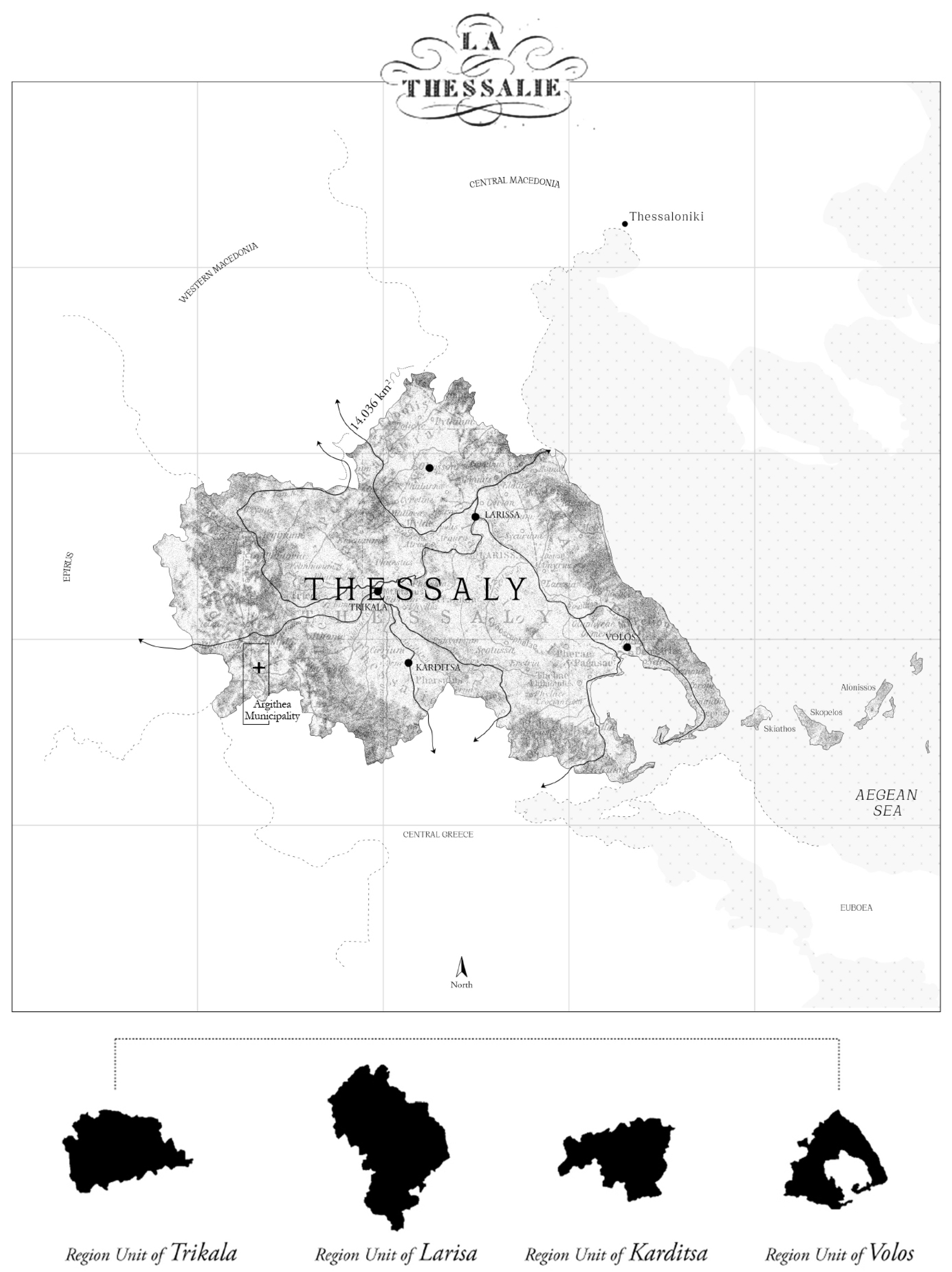
Figure 1.
Municipality of Thessaly. The study area is located in the Region Unit of West Karditsa.
2.1.2. Geographical and Geological Context
Established in the 18th century, Patlia comprises 14 stone and wood-built houses arranged in a manner that reflects the traditional architectural style of the region. The settlement's integration with its hillside underscores the interdependence between human habitation and the land. The Thessaly Region, encompassing an area of 14,036 square kilometers (approximately 11% of Greece's total land area), features a diverse landscape characterized by vast agricultural expanses and varied terrain. About 50% of the region is mountainous or semi-mountainous, with the remaining 50% comprising plains, including the Thessalian Plain, which is the largest plain and wheat field in Greece. This plain is traversed by the Peneios River, the country’s third-largest river [17].
Patlia is situated within the Municipality of Argithea, which extends to the western edge of the Karditsa Regional Unit. It is bordered by the Regional Units of Arta, Aetolia-Acarnania, Evrytania, Trikala, and by the Municipality of Mouzaki and the Municipality of Plastira Lake in the Karditsa Regional Unit. The seat of the municipality, Anthiro, is located 71.8 kilometers from Karditsa and 44.7 kilometers from Mouzaki. This inland mountainous area features elevations ranging from approximately 400 meters to 2,200 meters, with an average altitude of 1,015 meters. The region's geological composition includes rocks from the Olonos Zone of Pindus, which form parallel folds of metamorphic and Alpine formations. The resulting soils are well-drained, moderately or sufficiently enriched with organic matter, and exhibit a pH range from acidic to neutral [17,18].

Table 1.
The table indicates the evolution of the permanent population of Petrochori village. Petrochori is the nearest village to the settlement of Patlia and the main source of transhumance.
Table 1.
The table indicates the evolution of the permanent population of Petrochori village. Petrochori is the nearest village to the settlement of Patlia and the main source of transhumance.
| Year | Population | Variation |
| 1991 2001 2011 |
59 31 113 |
-47,46 264,52 91,53 |
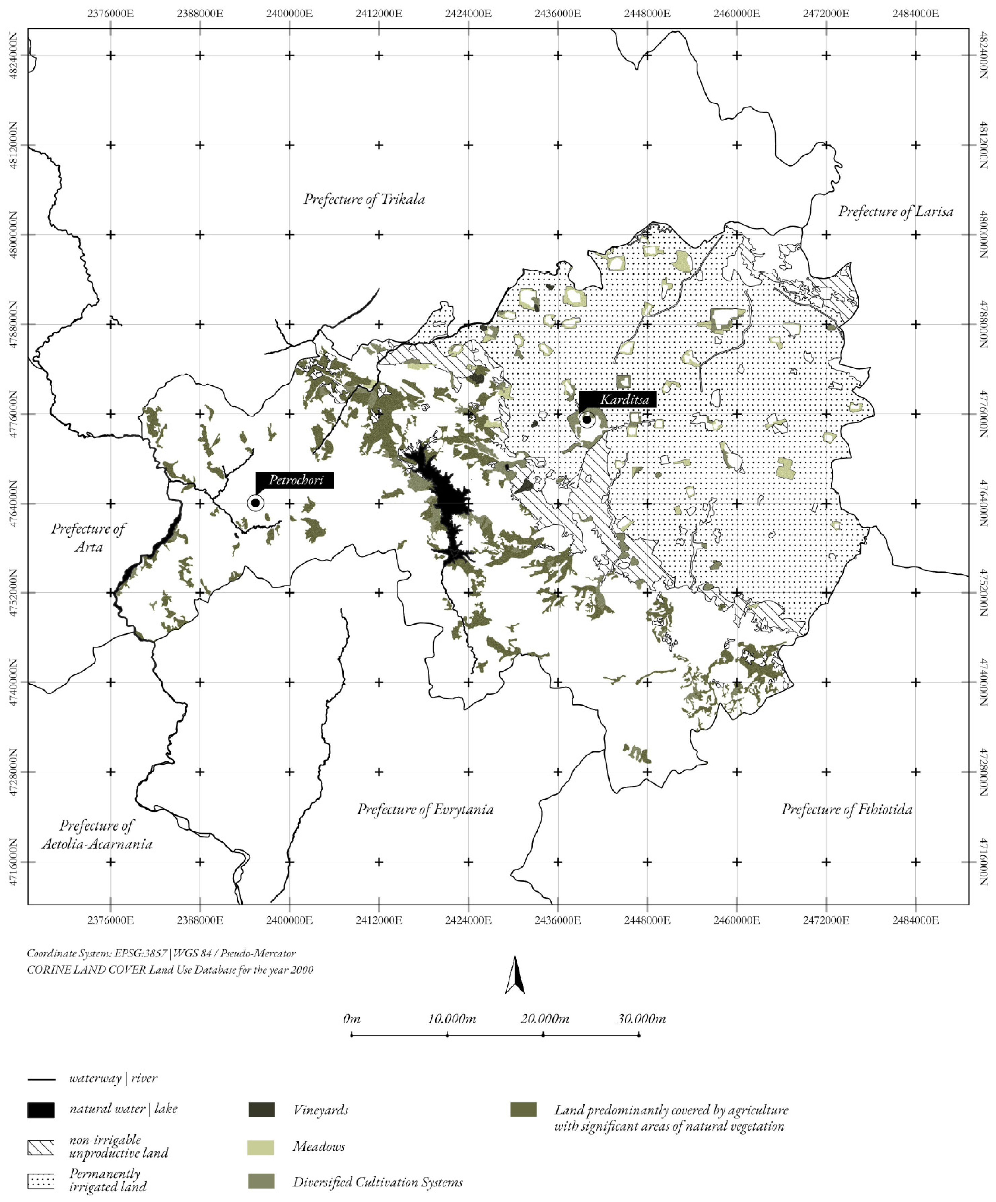
The land use distribution in the Municipal District of Ano Argithea, based on the 1991 census of the Hellenic Statistical Authority (Ε.Σ.Υ.Ε.), shows that the area covers 135,300 acres. These lands are categorized as follows: 3.6% cultivated areas, 22.5% forests, 67.6% pastures (with 64.6% communal and 3% private), 1.3% water bodies, and 1% settlements, with the remaining 4% classified as miscellaneous areas. Within the Municipality of Petrochori, which spans 9,100 acres, pastures account for 78%, forests for 12.1%, cultivated areas for 2.2%, settlements for 1.1%, and miscellaneous areas for 6.6% [19].
Figure 2.
The Agricultural areas map of the Prefecture of Karditsa. The relation between the project area, -Petrochori- and the urban center of Karditsa is highlighted.
Figure 2.
The Agricultural areas map of the Prefecture of Karditsa. The relation between the project area, -Petrochori- and the urban center of Karditsa is highlighted.
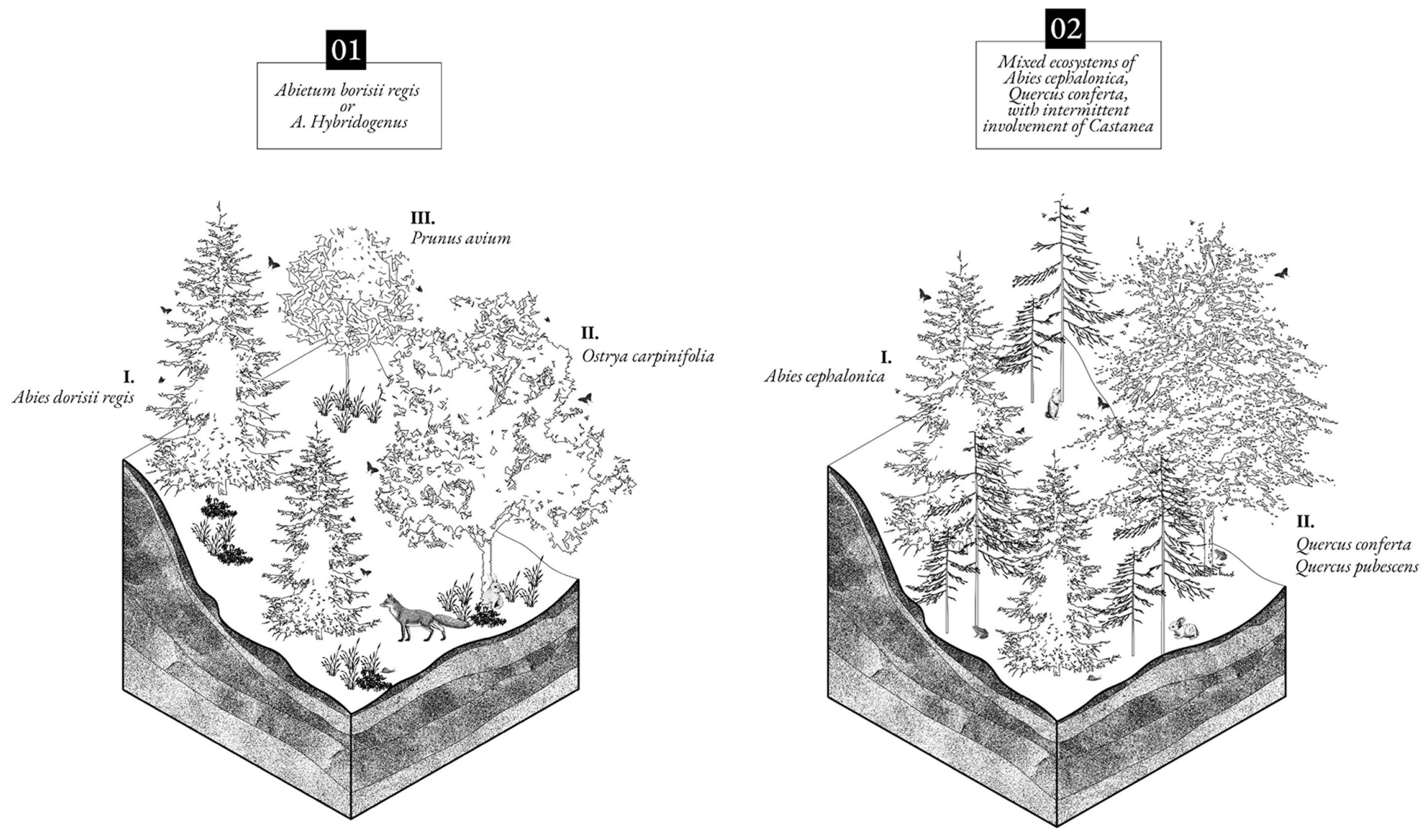
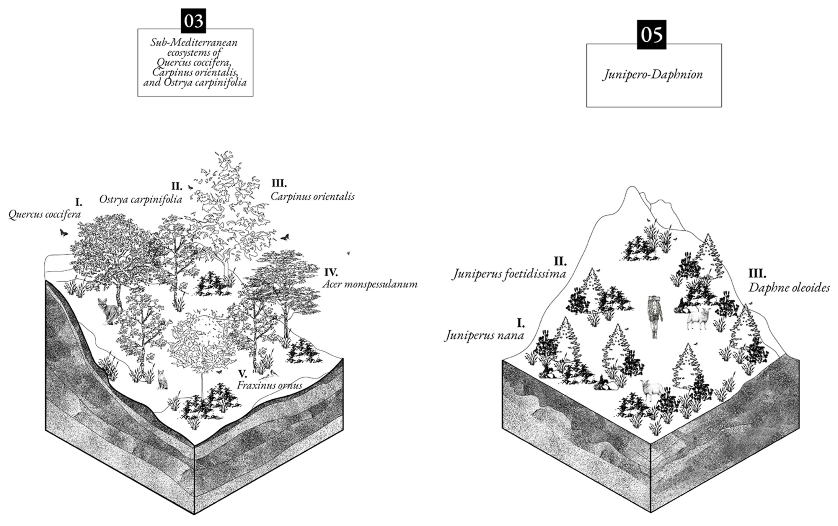
The study area is characterized by several distinctive ecosystems:
01. Abietum borisii regis or A. Hybridogenus developing at elevations of 900 to 1,600 meters. They exhibit diversity in location, structure, and organization. The fir species is characterized by polymorphism, a broad ecological range, significant economic benefits, and dominance at the higher elevations of the study area. Accompanying the ecosystems of hybridogenetic fir are species like beech, wild cherry, bitter chestnut, hop hornbeam, and oak while typical accompanying herbaceous species are Luzula forsteri, Lathyrus laxiflorus, Aremonia agrimonoides, Potentilla micrantha, Helleborus cyclophyllus, et al. [20]
02. Mixed ecosystems of Abies cephalonica, Quercus conferta, with intermittent involvement of Castanea, developing in the transition zones between the oak and fir zones. These transitional systems, if undisturbed by extreme weather conditions, culminate in forests, predominantly featuring the fir species in favorable locations. At lower elevations, the mix and prevalence of oak or fir depend on micro climate and soil conditions. In many cases, chestnut ac companies oak, with or without fir, and the accompany ing forest and shrub species are the same as those in oak and fir ecosystems, appearing in various combinations.
03. Sub-Mediterranean ecosystems of Quercus coccifera, Carpi nus orientalis, and Ostrya carpinifolia developing in specific locations and patches within the zone of mountain ous Mediterranean conifers. These locations are rocky and degraded, usually found on ridges and slopes with a steep inclination and a west-southwest orientation. Dominant species include Quercus coccifera, Carpinus ori entalis, and Ostrya carpinifolia, accompanied by Fraxinus ornus and Acer monsesulanum. [20]
04. Fagetum moesiacae occupying small areas at higher ele vations. The sensitive beech species has limited presence in the wider Argithea region compared to other forest species, primarily due to human interventions. A signifi cant beech habitat extends over an area of approximate ly 3,000 hectares in the Kazarma region, on the border between the Municipal Unit of North Argithea and the neighboring Municipality of Mouzaki. This is the Agios Nikolaos beech forest, which, besides its ecological val ue, offers various recreational and environmental tour ism activities.
05. Junipero-Daphnion (Subalpine ecosystems) developing above the limits (mostly anthropogenic) of the forests, including shrubby and bushy vegetation with species such as Juniperus nana, Juniperus foetidissima, Daphne oleoides, and others. Overall, all pseudo-alpine systems develop ing on the mountain tops of the study area stand out for the landscape diversity and rare biodiversity.
06. Alpine meadows are found, adapted to withstand the extreme weather conditions of high altitudes, featuring small leaves for water conservation and dense foliage for adaptation to height. They are known for their unique flora, including various grasses, herbs, and flowering plants adapted to survive in the harsh conditions. Plant species in these ecosystems are often low growing to withstand the strong winds and extreme temperatures. Combinations of shrubby and herbaceous vegetation, such as clusters with thorny shrubs (Astragalus) and grasses (Gramineae), e.g., Festuca (perennial tufted grass es), at high altitudes [20].
Figure 3.
The project area characterized by these distinctive ecosystems. (01) Abietum borisii regis or A. Hybridogenus (02) Mixed ecosystems of Abies cephalonica, Quercus conferta, with intermittent involvement of Castanea (03) Sub-Mediterranean ecosystems of Quercus coccifera, Carpi nus orientalis, and Ostrya carpinifolia (05) Junipero-Daphnion.
2.1.4. Flora and Fauna
The rich flora of the Patlia area is complemented by a diverse fauna. The mountainous continental Greek region supports a variety of vertebrate species, including roe deer, European hare, wild boar, badger, and occasionally brown bear, Eurasian lynx, and the rare wildcat. The avifauna includes 67 recorded bird species, with rare raptors such as the bearded vulture and the golden eagle inhabiting the high peaks. Reptiles found in the area include the slowworm, snake-eyed skink, and various lizard species, such as Ablepharus kitaibelii, Podarcis muralis, and the chameleon. Lower altitudes host species such as Elaphe quatuorlineata, Natrix natrix, the green lizard, the grass snake, the viper, Emys orbicularis, and Mauremys caspica. Prominent amphibians in the region include the fire salamander, yellow-bellied toad, newt, alpine newt, green toad, common toad, and several frog species [18].
2.2. In Situ and Archive Research Methodologies
2.2.1. Tangible and Intangible Elements
The locus of Patlia from isolated and uninhabited begins to come alive through the transhumance and the movements of the local shepherds and the herds. As it is mentioned, in 1982 the first attempt of link was achieved and the families from Petrochori, that occupied with the livestock farming, started to build their stone hunts in order to accommodate their families and herds for the months between April and October. [17] The procedure of the transhumance required significant preparations for the families and the animals, and the movement on its own could have lasted up to one month. [18] Usually the men of the family, had to move there first with the purpose of fixing any damages from the hunts, preparing the place to receive the families and the animals and providing the place with water and light sources. Winters on the mountains were exceptionally harsh and caused damages on the roofs of the buildings and especially on the wooden parts of the structure.
The movement of the herds to the mountains was one of the most significant and uplifting events for the habitants of the village, as some of the shepherds, during the winter season, were staying in Petrochori, but some of them were moving to the lowlands, to places with warmer climate conditions. As a result, it was a return trip for them to reunite with their families, before departing for the settlement of Patlia. [17]
The passage through the village consisted of an ephemeral stop in order to supply the herd with food and to prepare their equipment for the mountain ascent. The trip from Petrochori to the settlement of Patlia was short, lasted approximately 1- days with the several stops of the herds and the families.
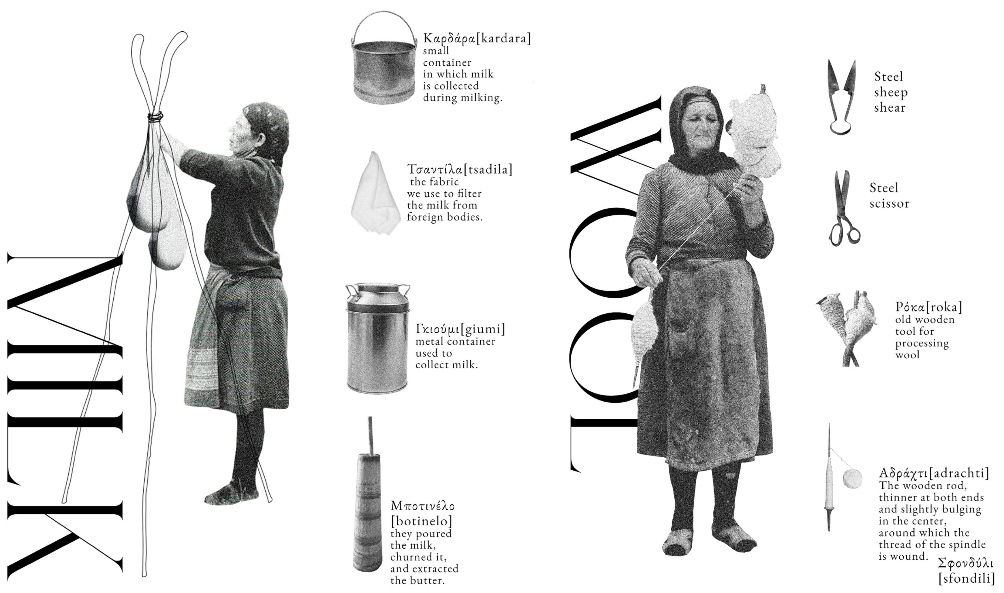
With the arrival on the settlement, all of the habitants, women and children, had to work together to organize their daily routine for the upcoming months. The days were starting early in the morning with the feeding of the herds, the timber harvesting for lighting and cooking provision, the cleaning and preparation of the space where the raw materials from the animals and the production of the food were making and the general household chores. The main occupations in the settlement were firstly cheese processing and production. Twice a day, during the sunrise and sunset, the shepherds had to shear the sheep and collect the milk into wooden buckets. The women transferred the milk to small spaces that were aside of the houses and specifically used for the cheese production and storage. From the milk many nutrition products were manufactured, such as cheese, butter or yogurt, so the families that possessed animals, and specifically sheep, were always occupied with food supplies.
While observing the equipment and the tools owned by the families, one can distinguish the loom for the wool processing. From the shearing of the sheep, the amount of the wool was separated by color and size and was cleaned with water. After that, they had to untangle and give the hair the same formation in order to be prepared for the loom. That was an important element of the intangible heritage of each family, that moved from generation to generation and provided the household with not only clothing, but also blankets, rugs, fabrics and the folk clothing of the shepherds. As the altitude on the mountains was high, the weather conditions were harsh even during the summer months. The shepherds were wearing a woolen cloak to protect them from the cold and the rain and so as the women were wearing woolen dresses and cloaks, and head covers. [17]
Figure 5.
The intangible traditional practices. The process of milking and the tools for the cheese production. The practice of woo knitting for the fabric making process.
Figure 5.
The intangible traditional practices. The process of milking and the tools for the cheese production. The practice of woo knitting for the fabric making process.
2.2.2. Organization of the settlement
Field observations began from Petrochori, where along a 7-kilometer path, several old stone dwellings were identified. These structures, remnants of anonymous architecture, were originally used for the ephemeral stay of herds during their seasonal movements. Integrated into the landscape, these "small stone boxes" interrupt the natural continuity and illustrate the tangible heritage of the region.
Archival research and field observations revealed the evolution of these structures over the years. Initially small and constructed from local stone, they later transformed into more spacious environments to accommodate larger herds. Despite changes in materials, the typological and technical approaches remained focused on sustainability, utilizing natural elements for ventilation and interior space organization.
No specific routes existed for the herds' movement up the mountain. Instead, sheep created improvised pathways, some still visible today, offering an alternative perspective on the space, reflecting the memory and history of the region. Sheep moved in closed formations, protecting one another and searching for safe grazing areas, resulting in unique shapes and patterns on the ground.
Figure 6.
The movement of the herds from Petrochori to the settlement of Patlia. Sheep follow no specific path, but moving along with the natural elements and environmental conditions.
Figure 6.
The movement of the herds from Petrochori to the settlement of Patlia. Sheep follow no specific path, but moving along with the natural elements and environmental conditions.
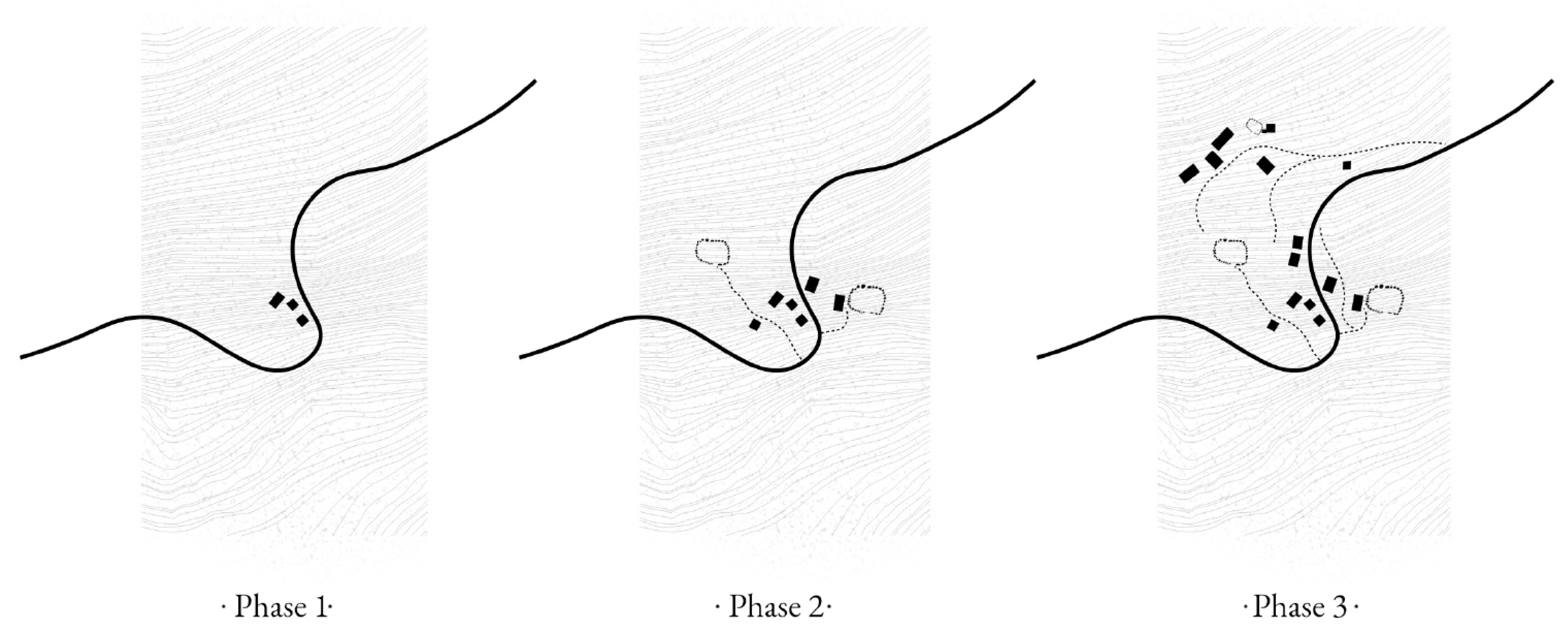
The settlement of Patlia is characterized by closely clustered buildings, creating a small enclosure where the path divides into two parts. Early established families built their houses in close proximity for mutual protection and clear views beyond the settlement. Three outdoor stone enclosures along the path were used for locating animals at night, positioned near the settlement for safety and to facilitate milk production and processing. A small church with a steel cross stand on a hill, distinct from the residential structures, organizing the settlement like a small village adhering to community design principles.
In the 1990s, technological and cultural advancements led to changes in Patlia's isolation. The need for herds to relocate for nutritional enrichment diminished, leading many families to leave the area. Remaining shepherds merged their herds and repurposed the structures to optimize animal management and production. Many houses were converted into storage spaces, with some buildings undergoing modifications due to spatial changes and time-induced damage.
In 1982 the locus of Patlia from an isolated land began to transform into an organized place, a small autonomous community. Within the settlement, 12 buildings and 3 enclosures were built. The architecture of Thessaly is influenced by the local materiality, the traditional adornment and the climate conditions. Stone and wood combined, form simple structures enhancing functionality and sustainability. The organization of the typologies of the houses followed the design principles of the traditional stone houses of Petrochori.
Figure 7.
Organization of the livestock settlement of Patlia. Phase 1: Genesis of settlement. Phase 2: Collaborative expansion. Phase 3: Organically shaped community.
Figure 7.
Organization of the livestock settlement of Patlia. Phase 1: Genesis of settlement. Phase 2: Collaborative expansion. Phase 3: Organically shaped community.
All the buildings are constructed with stone, sand from the local streams and limestone. [17] The structure of the roof is autonomous and built with wooden beams and trunks. They are single story with openings only on the front façade. The thickness of the outside walls are 0,50 meters and there is one entrance to access the house.
The analysis of the buildings prioritized their characteristics over cadastral definitions. Specifically, a typological examination enabled the identification of certain structures as residential, others as basic rural storerooms, and some as sheepfolds. This classification may cut across cadastral designations. Such an approach also provides a basis for intervention by considering the volumetric aspects of the houses, envisioning them within common scenarios that contribute to a cohesive landscape.
Furthermore, this method liberates the design process. The buildings originated spontaneously during the transhumance period, with their use gradually evolving into residential spaces through the addition of volumes. While informally the purpose changed, this transformation was not officially documented, and all structures are formally recognized as rural shelters. This disparity with the actual features of the houses creates an evident contradiction and, more significantly, hinders the development of a local community. Consequently, the village remains in a state of abandonment, as cultivating the land alone is not financially viable enough to repopulate the dwellings.
The typological analysis focuses on traditional structures constructed from stone. These buildings exhibit a morphology that not only mirrors their intended purpose but also reflects the topographical attributes of the landscape, the construction methods employed, and the alterations they have undergone. The majority of these houses are situated in locations marked by the pronounced incline of the terrain, displaying a straightforward design seldom comprising more than a single cell.
Figure 8.
A depiction of the construction details of a stone structure. It consists of a single room space of the housing building of typology 3.
Figure 8.
A depiction of the construction details of a stone structure. It consists of a single room space of the housing building of typology 3.
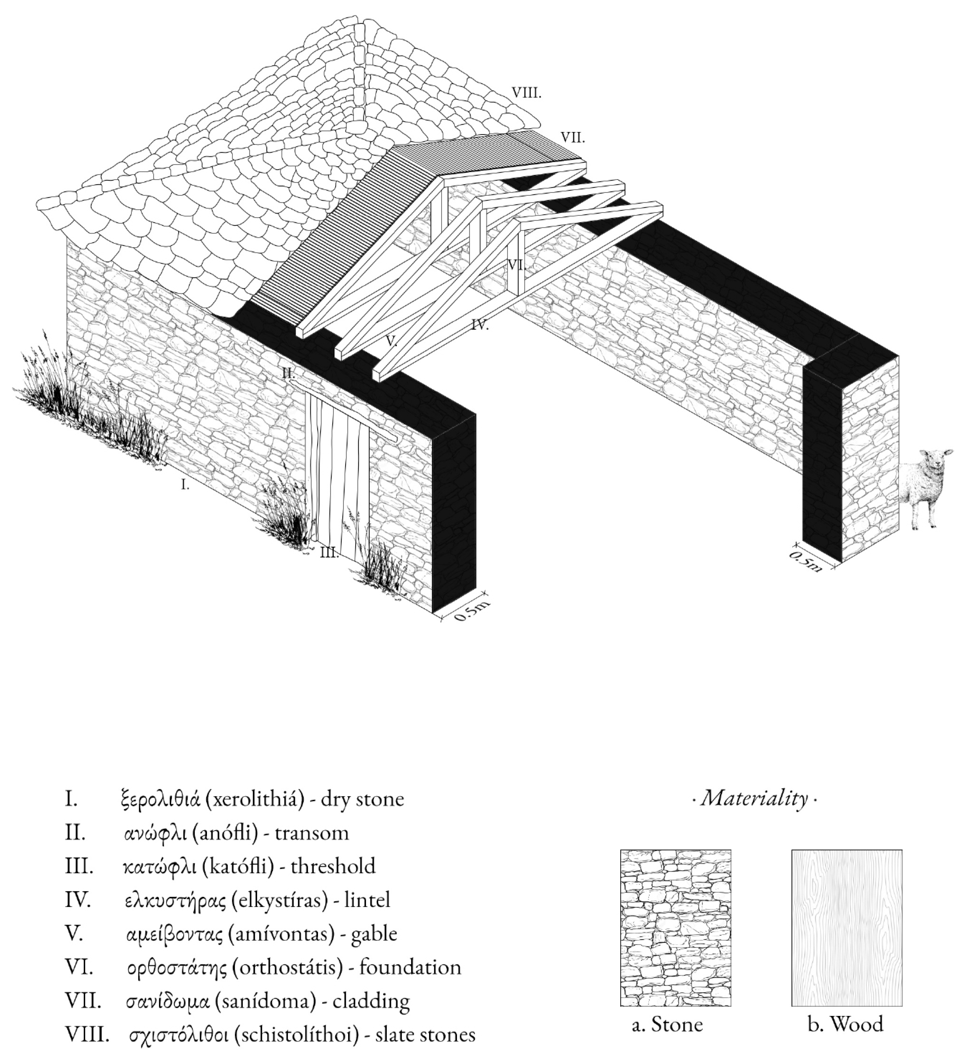
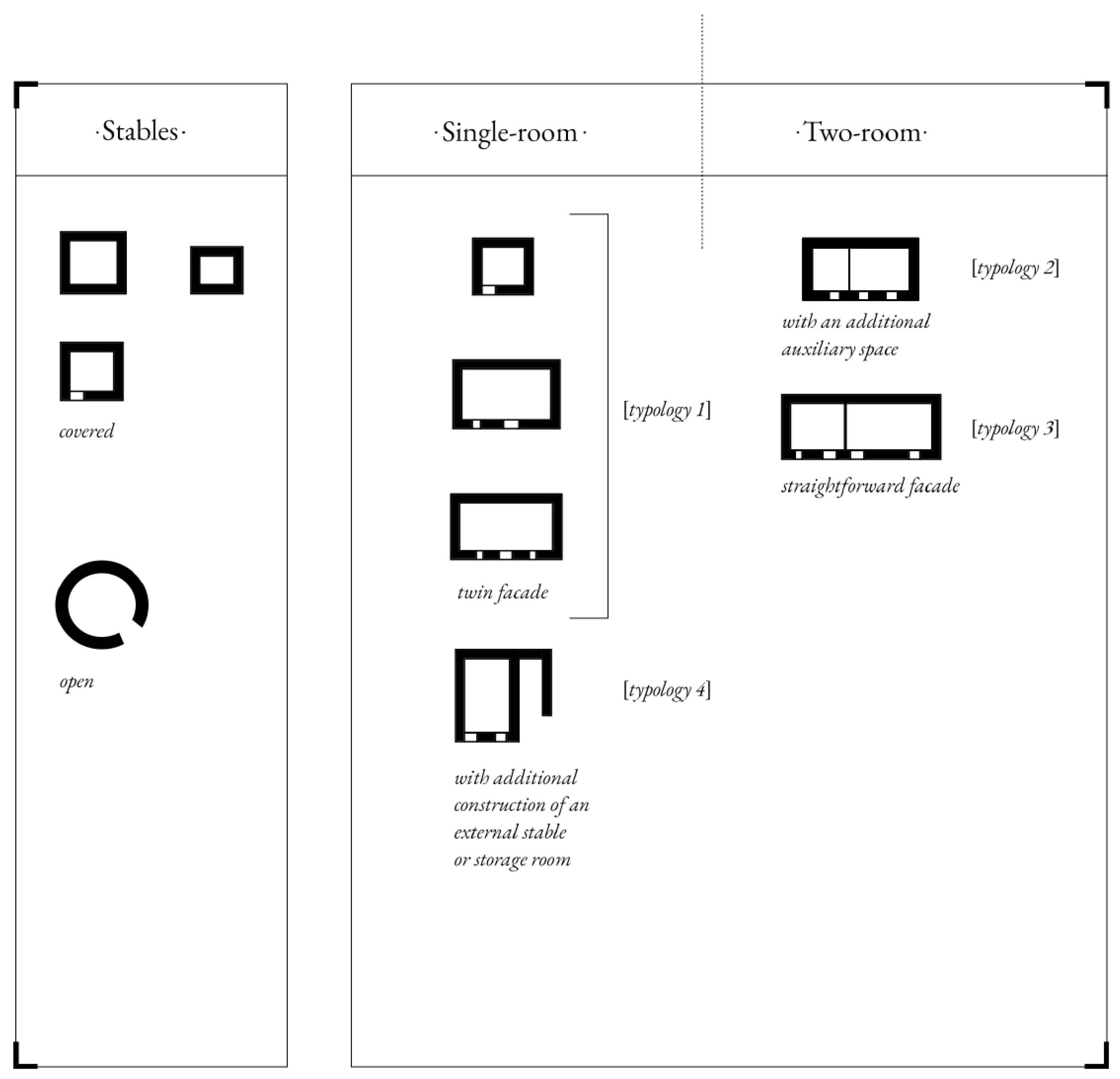
Typology 1
Single story building with a gable/two-sided roof. It is the simplest type of building found in the settlement. They have a very simple volumetry made up by a single cell with a rectangular shape. Typically, they only present one floor, most of the times partially laying against the terrain. The space is limited to an open plan room. Characterized by a modest appearance that utilizes by untreated materials. On the façade the stone components are visible and there is one or two ambiguous windows to the wooden door, that guarantees the access but also light and fresh air circulation. On the back wall of the façade there is a space for fire and sometimes, illumination and ventilation are supported by a single squared hole of a very small size. The height up to the roof beams is 2,5 meters and the dimensions is approximately of 3 - 4 meters per side. These buildings were mostly constructed at the purpose of serving and support the livestock activities, indicating poor maintenance, and in some cases, abandonment.
Typology 2
Single story building with a four-sided roof. This typology includes buildings with a mixed use, that meet the needs of the livestock activities but also adapted to meet the needs of temporary residency. They also feature an easy compositional scheme organized around a two-room cell with a rectangular shape, this time as large as 6 - 7 m per side. In this particular typology of building the significant characteristic is the size of the front façade, giving a rectangular shape having two entrances and one or two windows on the front wall. This type of structure is a possible subsequent arrangement with the purpose of sizing up the spaces inside, by uniting two dwellings. The plan is organized in two rooms with the same use of accommodation and a small space for storage.
Typology 3
Single story building with a four-sided roof. It appears same characteristics with typology 2 but also adapted to meet the needs of two temporary residencies. On the façade the stone components are visible. In this particular typology of building the significant characteristic is the size of the front straightforward façade, giving a rectangular shape having two entrances and one or two windows on the front wall. The building has a one space for accommodation with a fireplace on the back wall. Attached to it, there is a twin space. Most of the times the front façade is more than 10 meters, there is an extra space where the cheese and milk are being produced and stored respectively
Typology 4
Single story building with a three-sided or two-sided roof. It represents a typology with modern interventions and alterations. Their structure is characterized by a single rectangular cell and there is an extra space where the cheese and milk are being produced and stored respectively. Usually, they have only one floor, often partially nestled into the terrain. On the façade the stone components are visible and there is one or two ambiguous windows to the main entrance. Inside the building, there is an open plan space with the fireplace on the back wall. The exclusive use of this typology is for housing.
Figure 9.
Structural typologies in the settlement of Patlia. The stone structures are divided into the buildings, with the basic use of housing and/or warehouses, and the formations of the stables.
Figure 9.
Structural typologies in the settlement of Patlia. The stone structures are divided into the buildings, with the basic use of housing and/or warehouses, and the formations of the stables.
2.3. In-Depth Interviews as Complementary Urban Analysis Tool
As part of our research methodology, we conducted a series of in-depth interviews with key stakeholders to gather insights into both Patlia and the practice of transhumance. These interviews utilized semi-structured and unstructured formats; qualitative research methods aimed at developing a deep, nuanced understanding rather than merely collecting factual data. This approach was particularly valuable during the Finding phase of our research, helping us uncover and explore the unique qualities and characteristics of the site and the transhumance tradition.
The interviews focused on gathering qualitative and experiential data, emphasizing local knowledge and perceptions. This method was crucial for validating or challenging the outcomes of our previous research phases, namely Landing and Grounding. By collecting and comparing diverse perspectives on Patlia's and the transhumance practice's past, present, and future development, the research team could tailor their study to the grounded needs and perceptions of the community.
In conducting these interviews, we considered both tangible and intangible aspects of the area's heritage, recognizing their significant roles in shaping local identity. Interviews were conducted either face-to-face or through phone and video calls. The format of the interviews was flexible, with semi-structured or unstructured discussions taking place either on-site or in locations familiar to the interviewees. This method ensured a comprehensive capture of various viewpoints, contributing to a holistic understanding of Patlia’s distinctive landscape, heritage, and the practice of transhumance.
Table 2.
This table indicates the stakeholders’ in-depth interviews during the project area visit. Additionally with the different characteristics indicated, a summary of their comments is provided.
Table 2.
This table indicates the stakeholders’ in-depth interviews during the project area visit. Additionally with the different characteristics indicated, a summary of their comments is provided.
| Interviewee | Characteristic | Comments |
|---|---|---|
|
Vasilis Kissas |
Patlia, Thessaly 83 years old, dedicate his life to breeding. |
“The initial years posed challenges, as all necessities had to be transported from Mouzaki, a 45 klm journey on foot, accompanied with animals.”, “The milk produced here characterized by its quality and abundant quantity.” |
|
Nikos Siafarikas |
Avdella, Western Macedonia 25 years old, facing challenges in transhumance. |
“A founded program for transhumance could also provide the motivation we need to continue stockbreeding…the lack of support from the State has been a hindrance. If there were assistance, I would certainly consider continue this profession.” |
3. Results
3.1. General Strategy
Patlia finds itself in a delicate state, demanding a meticulous strategy to resurrect its vitality. Any settlement plan must carefully navigate around economic exploitation, ensuring the village’s return to self-sufficiency. This calls for a flexible strategy that not only guarantees long-term engagement but also encourages various stakeholders to reap benefits beyond financial gains. Embracing the positive impact of rural living on people’s lives, this approach not only enhances the economic value of assets but also situates the strategy within a broader framework, aspiring to revive the entire landscape, along with its stories, techniques, and traditions.
The uniqueness of Patlia lies in its inseparable coexistence with the landscape across multiple dimensions. A sustainable intervention plan must view the development of the settlement and the landscape as an interconnected process. The revival of the transhumant lifestyle and preservation of the built heritage are intertwined aspects crucial for maintaining the delicate balance between humanity and nature, which once defined the territory’s vibrancy and dynamics.
The bygone era is no longer an option for Patlia’s residents, urging them to explore new ways of living. Embracing coexistence with tourists presents an opportunity not only for residents to live and work in the settlement but also for initiating cultural exchanges.
Isolated and serene, Patlia is detached from the hustle of modern life, making it an ideal refuge for those seeking tranquility, beauty, and silence. It serves as a haven for various forms of slow tourism, where individuals eager to learn traditional skills like cheese-making, woolen textile creation, animal care, drystone wall construction, or ancient house renovation can engage in a living workshop. Young families and retirees desiring an escape from urban chaos can discover a peaceful haven for a temporary stay. For smart workers liberated from the constraints of a physical office, Patlia becomes an efficient workspace, offering a chance to meditate and reconnect with nature. These individuals contribute to the regeneration of the village’s lost agriculture, taking on rural tasks, exchanging cultures, and immersing themselves in the holistic experience of Patlia.
Central to this development is the concept of the experience economy, where products and services are crafted to provide customers with not just a commodity, but an enriched encounter filled with adventure, learning, and unique experiences. Every day people are demanding a better quality of life. This is the core of the development of products and services in the frame of the experience economy. Coined by B. Joseph Pine II and James H. Gilmore in 1998, the term “experience economy” emphasizes the additional revenue generated by infusing value into a service through a memorable experience. When a service is purchased, it involves intangible activities performed on behalf of the buyer. However, investing in an experience means paying for the opportunity to immerse oneself in a sequence of memorable events. The scope of the experience economy extends beyond the realm of shopping to encompass sectors like tourism in more established economies.
Tourists can engage in a short or long-term, slow tourism program where they can learn about traditional products, their production methods, and participate in workshops related to tasting and creating recipes inspired by the region’s products and techniques. They could also benefit from an exclusive location that can provide them with a truly authentic experience. They can become a part of this settlement, even taking part in hikes along the region’s mountain trails—a sanctuary for them along their journey. A stop.
For this reason, they constitute a fundamental factor in the evolution of this economic model, as they can pay rent for renting a house and become members of the activities. They should be made aware that life in a remote settlement has some practical implications and standards to guarantee its sustainability, rewarded by the extraordinary location and the advantages of its isolation. They should be respectful of the environment and incentivized to participate in the life of the community.
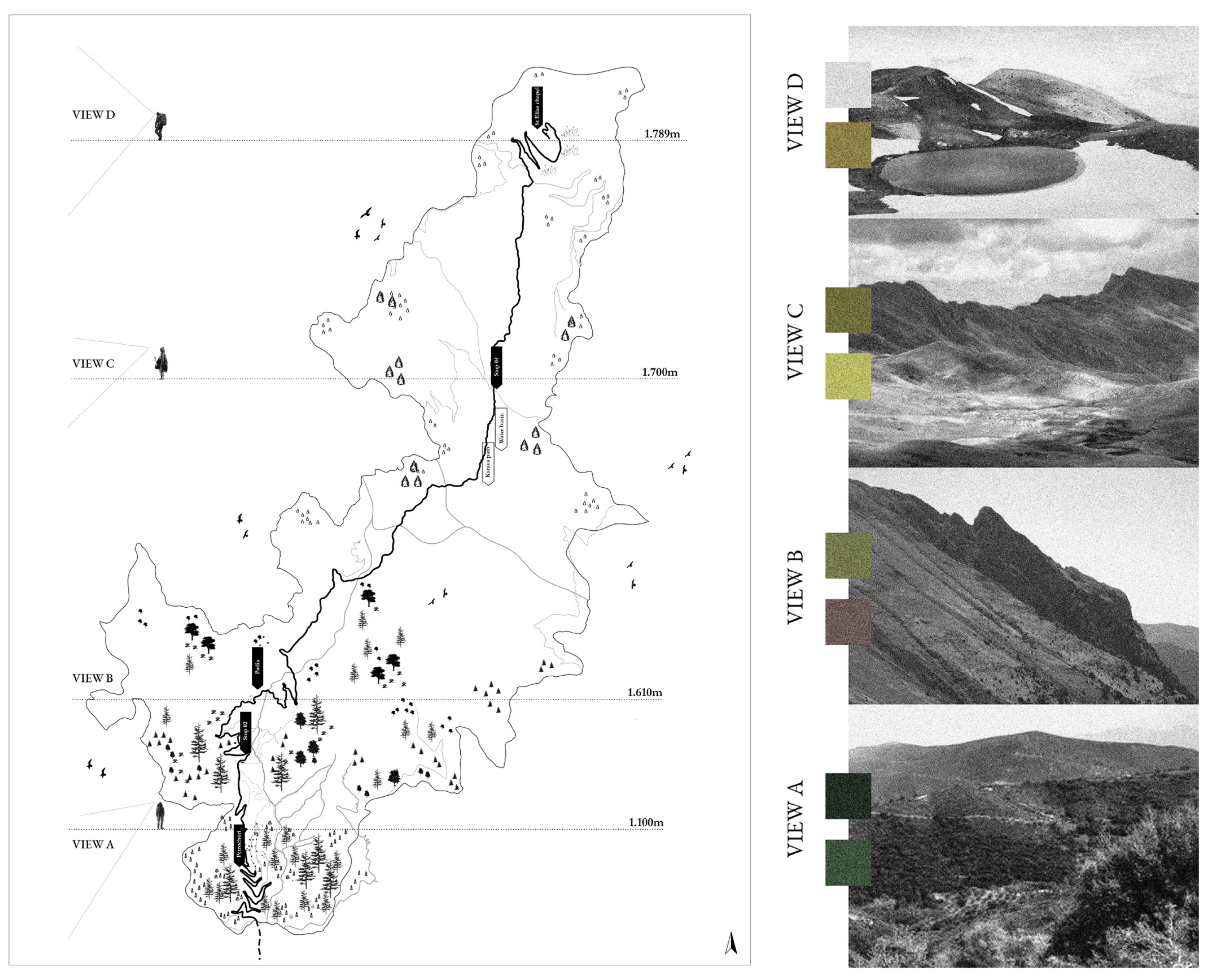
Figure 10.
The different ecosystems along with the different altitudes on the study area point of views.
Figure 10.
The different ecosystems along with the different altitudes on the study area point of views.
3.2. Guidelines
In the realm of landscape preservation, three primary criteria have been established:
0.1Preserving panoramic views. Tracing the routes is followed by pointing out the site symbols. From the geographical features, such as streams or pasture areas, in relation to certain landmarks, such as the stone water trough or the nearby communities. These elements are creating an unofficial network between the herds’ stops, characterized by resting and pasture areas, highlighting the positions of the area views.
0.2Maintaining the integrity of settlements and their tra ditional features. Through the transhumance, Patlia’s settlement has the opportunity to revive the traditional practices and to attract different types of land users.
03.Upholding the rural character of the landscape. Sheep’s compression of the movements and grazing ability on the mountains are capable to maintain a perpetual ecology succession. The size of the sheep allows them to constantly graze into the root system, causing soil erosion and creating fire breaks areas. [22]
In light of these considerations, the preferred approach for intervention leans towards minimal action. This ap proach aims not only to safeguard the original elements but also to prevent any compromise to the intangible values that contribute to the authenticity of the artifact. Best practices for rural structures encompass:
01.Upholding the original constructional idea by following the traditional floor plan. Despite of the new uses of the buildings given, the indoor arrangement follows the typologies of the existing traditional structures with the one/two room spaces.
02.Maintaining the components of the construction and re-using them to create new formations. With the wooden components, new small structures are creating in order to serve the traditional farming techniques of the settlement and expand the space for the indoor everyday needs.
03.Preserving the constructional systems through sustainable ways, by using wood and stones from the near water streams. Imitating the traditional practices, humans have the opportunity to reinforce the constructional frame and maintain the form.
04.Integrating modern materials and techniques in har mony with the traditional ones, as the settlement’s guidelines follow a sustainable and low intervention strategy. Using a bioclimatic sustainable system, take advantage of the natural elements, such as the natural ventilation, the water harvesting and the solar energy.
These principles serve as a guide to discern which in terventions are compatible, incompatible, or viable with caution.
3.3. Landscape strategy
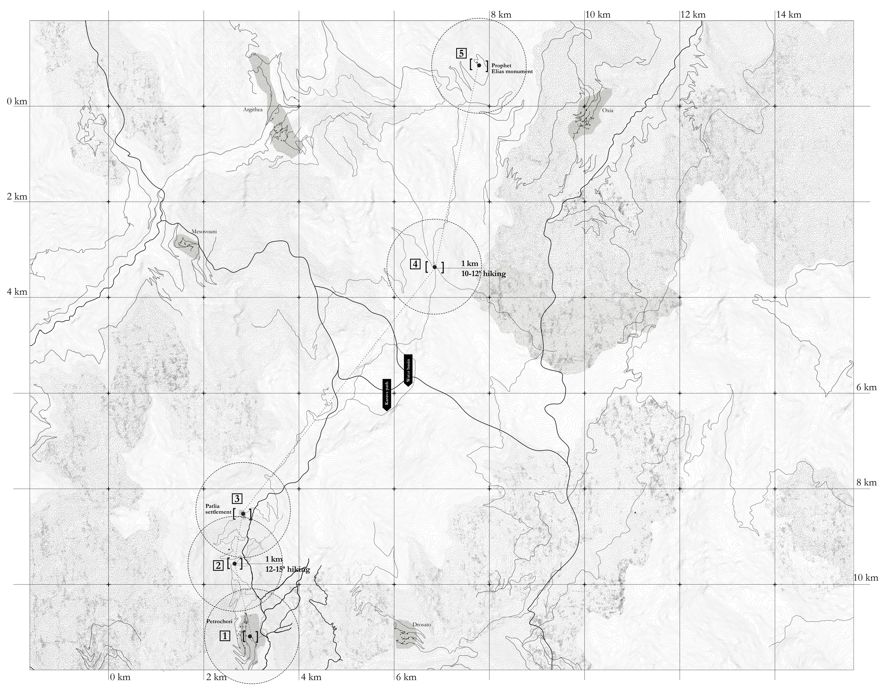
Human intervention is as heroic as ephemeral: without the path, the locus of Patlia would have been complete ly inaccessible, without the rocks, the landscape would have been impossible to inhabited. Architecture com plements and refines everything that nature has left in complete. One could argue that humans do nothing but complete various landscapes in their constructions that nature neglected to arrange according to human pref erences for a more comfortable, pleasant, and beauti ful way of life. Instead of fighting against harsh nature, early inhabitants decided to modulate their settlements according to the features of the site. [23] For this reason, the relation between men’s actions and landscape is bond by a meaningful, but fragile, link. The presence of a steeper cliff or a smoother sequence, the widening of the trail, the existence of a water element, the need for relaxation—all become relative elements that orient the path. Man’s action is always shaped over the features of the landscape, integrating and completing it. People of transhumant life traditionally embarked on extended journeys, adhering to distinct routes intricately linked to the landscape, water elements, and climate conditions. Each stop in their journey held a specific purpose, with its own unique narrative. Now we can say that the pur posed intervention moves along the same direction.
The path commences in Petrochori village, culminating at the summit of Karava, where it intersects with other hiking routes. The project’s objective is to enhance the path’s fluidity by incorporating strategic stops. The stops are located in relevant locations where the user perceives a break in the continuity of the landscape: it may be the place where the path becomes tight, where the an cestors created a fountain, where the trekking faces a particularly challenging point, where the village begins or where the path ends. The stops are thoughtfully po sitioned considering the path’s steepness and difficulty, ensuring individuals find suitable places to rest when fa tigue sets in.
Every spot adheres to the design rationale of established human settlements of the area, where orientations align with contour lines, and the construction partially ex tends over the side of the hill.
Figure 11.
Masterplan of the landscape strategy. The path’s starting point is located in Petrochori, crosses the settlement of Patlia and ends up on Prophet Elias monument on 1.789m above the sea level.
Figure 11.
Masterplan of the landscape strategy. The path’s starting point is located in Petrochori, crosses the settlement of Patlia and ends up on Prophet Elias monument on 1.789m above the sea level.
3.4. Settlement strategy
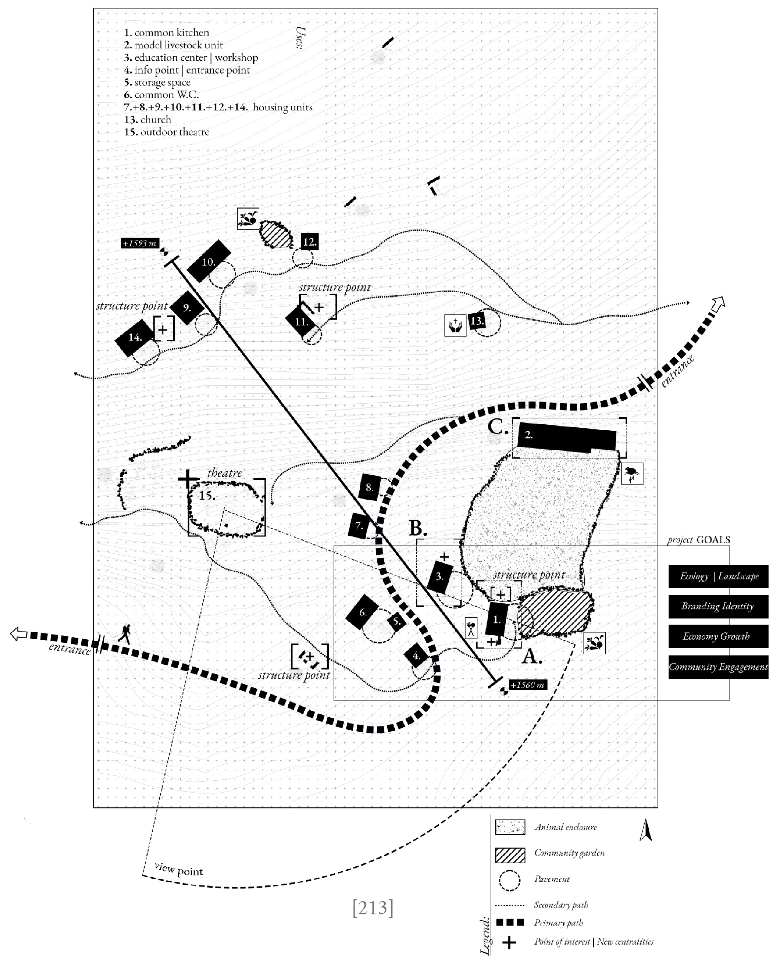
Our strategic approaches commence with the purpose serving by the settlement. To enhance the practice of transhumance giving a new identity to the place, that will reflect the past, using the tools of the present. Rec ognizing the morphology of the landscape that has been shaped according to the movement of the herbs throughout the years, our goal is to enrich the area with light interventions that will have the minimum footprint and set the nature as the prominent factor of growth. The settlement of Patlia will acquire an autonomous economic system, in connection with the shepherds and families from Petrochori, that will create an engaging to the local community. The materiality of the interven tions gives a sustainable character to the settlement, by keeping the stones walls of the structures and renovat ing the roofs with recycled wood. The small structures and the equipment that provide the settlement are made with recycled wood and local carpenters and workers. The main path preserves the old character of fixed soil and the floors inside the houses maintain the existing stone paving that continues outside, creating a small in dividual front yard. The proposal focuses on the maintenance of the ex isting structures, giving them a new identity based on alternative housing scenarios. Into the settlement there are thirteen buildings. The scenario concern people that moving with their herbs for permanent or semi-perma nent stay, people who have the ability of remotely work and desire to learn the shepherds’ practices, the hikers that pass through the locus and the families that stay during the summer months and are responsible for the smooth operation of the community.
The organization creates a sharing community, with a common kitchen, a place where the animals are being protected and grazing and a small workshop with all the local products available. At the entrance of the settle ment one can find the info point where is all the infor mation about the accommodation and way of living and about the hiking paths and routes. Alongside the main path the houses maintain a private character. The settle ment facilities provide to the inhabitants the opportuni ty to co-exist with the nature and animals, to experience the agricultural lifestyle, with small cultivation gardens and a place where one can be part of the milking proce dure and cheese making.
As mentioned, our goal is to [re-]create the sense of a communal place, with a circular economic system. A sharing community for residents, a gastronomic attrac tor for the visitors, a refuge for the hikers and a natural home for the animals.
Figure 12.
The settlement strategy guidelines. Prioritizing the role of the natural scenery, the interventions create a low impact on the initial settlement’s arrangement.
Figure 12.
The settlement strategy guidelines. Prioritizing the role of the natural scenery, the interventions create a low impact on the initial settlement’s arrangement.
4. Discussion
The settlement of Patlia would not exist without the movement of livestock into the woods and mountains, with families and shepherds shaping its formation. Today, contemporary living prompts us to create new scenarios for housing, working, and production. The traditional modes of living are evolving, presenting new perspectives. Transhumance sites, deeply connected with historical and cultural backgrounds, hold architectural value that is crucial for characterizing places. Our societies must now, more than ever, recognize the importance of these perspectives. [24]
Agricultural production and farming, though practices from the past, have adapted to contemporary conditions without cessation. By familiarizing younger generations with transhumance, we encourage the revitalization of settlements and grant new identity to existing structures. The movement of livestock enhances the landscape, creating routes for humans and ecosystems for animals.
A new community will emerge, rooted in past scenarios. Humans will live sustainably with nature and animals, promoting local products and services, improving the lifestyle of families and shepherds, and attracting those interested in cultural and traditional way of living.
The commonalities between a place of transhumance and a modern-day settlement reveal that Patlia can evolve into a contemporary residential destination. Learning from transhumance is feasible and essential to exploring new settlement scenarios. Our research shows that Patlia's architecture supplements and refines nature, completing what nature leaves unfinished. When architecture integrates seamlessly with the landscape, it becomes a second nature.
By analyzing the spatial and social identity of Patlia, the research has uncovered its rich past while envisioning bold future scenarios. Addressing the challenges of neglect and abandonment, the research highlights the interconnectedness between transhumance and anonymous architecture's legacy. It celebrates the symbiotic relationship between human activity and the natural world, weaving a narrative that honors tradition and innovation.
Patlia is not a static relic but a dynamic landscape with untapped potential. By leveraging design and community engagement, the research envisions a thriving future for the settlement, transforming it into a hub of cultural exchange and environmental stewardship.
The journey of the research has been one of discovery and transformation, challenging conventional notions of progress and development. It embraces complexity, paving the way for a more inclusive and sustainable vision of the future. As Patlia embarks on a new chapter, the research stands as a beacon of hope and inspiration, demonstrating the power of imagination and creativity to reshape landscapes and celebrate forgotten settlements as vibrant centers of cultural and ecological diversity.
Moreover, Patlia can serve as a model for similar scenarios and places, offering valuable insights for future revitalization projects. By applying the principles and strategies developed here, other settlements facing similar challenges can embark on a path toward sustainable development and cultural preservation.
5. Conclusions
Patlia's delicate state necessitates a strategy to revive its vitality. This research contributes to the analysis and promotion of the traditional transhumance practices, emphasizing on the preservation of intangible and built heritage, as a way of balance between humanity and nature.
According to the literature background, transhumance serves multifaceted social and environmental functions. [1] From the environmental perspective, it actively contributes to landscape shaping and significantly aids in the preservation of biodiversity. On the socio-cultural front, transhumance enhance the long-term engagement, as the livestock’s movements among areas act as a catalyst for the development of cultural identities and inter-community bonds.
The concept of the experienced economy, central to this development, enhances economic value through memorable experiences. Slow tourism programs allow people to engage in traditional practices and workshops, encourage the enrichment of the ecosystems and contributing to the local economy through a sustainable way. In the scenario of applying our findings to a different location, similar methodology would be implemented, based on the characteristics of the specific area. The strategic plan would prioritize the symbiosis between the landscape and the human presence, thus enhancing the relation of innovation and tradition.
In the present days, the contemporary urban living lead humans to create new scenarios of housing, working and production. The known module of living is changing and creates new perspectives. Concurrently, the places of transhumance provide obsolete spaces to the local producers and farmers, with the intention of revitalization of the settlement, giving new opportunities to the younger generation, supporting the local food production and the sustainability of biodiversity. The services and products will be promoted, and the lifestyle of the families and shepherds will be improved. These strategies though, require an extended and in-depth analysis of implementation, in order to be sufficient. As far the landscape’s strategy is concerned, a detailed agricultural plan necessitates to guarantee the revitalization of the environment and the ecology succession through the movements of the livestock. The study of the interventions, along the routes and into the settlement, consists also a pivotal element for the identity of the place. The exact location of the structures, the function and materiality should be presented in depth, integrating the different types of users across the seasons.
Transhumance is one of the most sustainable and efficient ways to farm livestock, according to UNESCO (2019). [5] As the research unfolded, it became increasingly clear that Patlia is not a static relic of the past, but a dynamic landscape teeming with untapped potential. It serves a valuable module for planners and policy makers, that with a defined approach can be applied on the abandoned transhumance settlements and agricultural dwellings in Mediterranean countryside.
As we proceed on the implementation of the proposed solutions, it would be an oversight not to conduct a detailed and in-depth planning under the guidance of rural and urban experts. Transhumance is a vital element of this research, thus the perspective and the communication with the ones who practice this way of life constitute also of outmost importance. Future research should explore further integration in order to enhance sustainable development and community engagement.
Through the meticulous investigation of the spatial and social identity of Patlia, this research has analyzed the architectural and cultural heritage of the loci while envisioning bold new scenarios for its future. It acknowledges the symbiotic relationship between human activity and the environment highlighting the challenges following the progress and development. This strategy defines a way to revitalize the abandoned settlement of Patlia through sustainability and innovation.
Author Contributions
The authors contributed equally to this work. Conceptualization, J.N.T., S.T. and S.K.; methodology, J.N.T., S.T. and S.K.; software, S.T. and S.K.; formal analysis, J.N.T. and S.K.; investigation, J.N.T. and S.T.; resources, J.N.T. and S.T.; data curation, J.N.T. and S.K.; writing—original draft preparation, J.N.T., S.T. and S.K.; writing—review and editing, J.N.T.; visualization, S.T.; supervision, J.N.T.; project administration, J.N.T.; funding acquisition, J.N.T. All authors have read and agreed to the published version of the manuscript.
Funding
This research has received funding from the European Union’s Horizon 2020 research and innovation programme under the Marie Sklodowska-Curie grant agreement No 872931-YADES program.
Data Availability Statement
Not applicable.
Acknowledgments
The research team is beholden for the support of the local stakeholders, who participated in the interviews and provided with crucial information and written material which reveal not only the history of the area, but also the current situation of the site. The in-person interviews offer a view to the unwritten insights and the sense of the place, as well as to the active projects and practices in the research site area. In particular we want to thank: Sotirios Filippou, Vasilis Kissas, Nikos Siafarikas, Dimitris Kissas and Savvas Theodoridis who volunteering support the research process.
Conflicts of Interest
The authors declare no conflicts of interest. The funders had no role in the design of the study; in the collection, analyses, or interpretation of data; in the writing of the manuscript; or in the decision to publish the results.
References
- Evans, E. Transhumance in Europe. Geography, 1940, 25(4), 172-180.
- Oteros-Rozas, E., Martin-Lopez, B., Gonzalez, J.A. Socio-cultural valuation of ecosystem services in a transhumance socio-ecological network. 2013, 14, 1269-1289. [CrossRef]
- Unesco.org. Transhumance, the seasonal droving of livestock. Available online: https://ich.unesco.org/en/RL/transhumance-the-seasonal-droving-of-livestock-01964 (accessed on 20 July 2024).
- Madurga, M.A.; Navarro, M.A.; Saz-Gil, I.; Sanz, S. Depopulation and Residential Dynamics in Spain: Sustainable Housing in Rural Areas. Urban Sci. 2024, 8(3), 110. [CrossRef]
- Unesco.ro Transhumance, the tenth element of intangible heritage inscribed in the UNESCO list. Available online: https://www.cnr-unesco.ro/en/activity/transhumance-the-tenth-element-of-intangible-heritage-inscribed-on-the-unesco-list (accessed on 10 August 2024).
- Easdale, M.H.; Michel, C.L.; Perri, D. Biocultural heritage of Transhumant territories. Agric Hum Values 2023, 40, 53-64. [CrossRef]
- Sidiropoulou, A.; Karatassiou, M.; Galidaki, G.; Sklavou, P. Landscape Pattern Changes in Response to Transhumance Abandonment on Mountain Vermio (North Greece). Sustainability 2015, 7(11), 15652-15673. [CrossRef]
- Iliopoulou, F. The “construction” of the Greek landscape in the Hellenistic era. OpenEditor 2012, 8, 11-16.
- Nasir, O.; Kamal, M.A. Vernacular Architecture as a Design Paradigm for Sustainability and Identity: The Case of Ladakh, India. American Journal of Civil Engineering and Architecture 2021, 9(6), 219-231. [CrossRef]
- Tzanakakis, M.K. Pastoralism in the Mediterranean: The Case of Greek Mountain Nomads. Journal of Med Studies 2020, 15, 143-160.
- Bougias, A. H. G. Pastoral Systems and Landscape Utilization in Greece: An Ethnoecological Perspective. Human Ecology 2010, 38, 489-500.
- Anderson, J. M.F. Cultural Landscapes and the European Landscape Convention: A New Framework for Planning and Protection. Environmental Planning and Management 2014, 57, 479-492.
- Koutsou, A.M. Mountain Pastoralism in Greece: A Study of Spatial Organization and Land Use. Geojurnal, 2006, 66, 215-228.
- Vicente, A. C. The Role of Traditional Transhumance in the Conservation of Mediterranean Landscapes. Landscape Ecology, 2013, 28, 1361-1374.
- Van den Berg, R.H. Modernization, Abandonment and the Future of Traditional Pastoral Systems in Europe. Journal of Rural Studies 2017, 55, 73-82.
- Tsakiris, I. P. The Role of Transhumance in Greek Landscapes: Biodiversity, Cultural Heritage, and Future Challenges. Land Use Policy 2017, 63, 477-486.
- Holevas, E. Το Πετροχώρι Aργιθέας (Σπυρέλο) – Μνήμες και Ρίζες του χωριού μας, 1st ed.; Publisher: Επιμορφωτικός Πολιτιστικός Σύλλογος Πετροχωρίου Aργιθέας «ΤO ΣΠΥΡΕΛO», Petrochori, Greece, 2014.
- Zois, G. Integrated Management of the Mountainous Volume of the Municipality of Argithea through Development Scenarios and their Evaluation Using the Analytical Method. Integrated Master Thesis, Faculty of Science, Aristotle University, Thessaloniki, Greece, 2019.
- Papathomas G. C.; Verra, D.K. Environmental Impact Study (EIS) of the Argithea Municipality of Karditsa Prefecture, Strategic Environmental Study. Available online: chrome-extension://efaidnbmnnnibpcajpcglclefindmkaj/https://argithea.gov.gr/wp-content/uploads/2016/09/smpe-sxooap-argitheas-r1.pdf (accessed on 10 August 2024).
- Koutsourdis, A.; Langone, M. Study of Lake Area Tourism Development with the Contribution of GIS and Remote Sensing. The Case of Plastira Lake. Integrated Master Thesis, Faculty of Science, Aristotle University, Thessaloniki, Greece, 2016.
- Pine B.J.; Gilmore J.H. The Experience Economy: Work is Theatre & Every Business a Stage, Publisher: Harvard Business School Press, Boston MA, USA, 1999.
- Ntassiou, K.; Doukas, I. D. Recording and mapping traditional transhumance routes in the South-Western Macedonia, Greece. Geohurnal 2019, 84, 161-181. [CrossRef]
- Konstantinidis A. Για την Aρχιτεκτονική, Δημοσιεύματα σε εφημερίδες, σε περιοδικά και σε βιβλία 1940-1982. 2nd ed.; Publisher: ΠΕΚ Πανεπιστημιακές Εκδόσεις Κρήτης, Greece, 2011.
- Zogib, L. On the Move – for 10’000 years: Biodiversity Conservation through Transhumance and Nomadic Pastoralism in the Mediterranean, Publisher: The Mediterranean Consortium for Nature and Culture, Switzerland, 2014.
- Boumba, S. D. The Overwintering of the Vlachs of Metsovo: Narratives and Biohistories, Integrated Master, National and Kapodistrian University, Athens, Greece, 2018.
- Berque, A. Mediance: De milieux en paysage., 2nd ed.; Publisher: Berlin, Paris, France, 1999.
- Oikonomou, A. Economy and Kinship in the Arvanite Mountain Communities of Kithaironas. 2nd ed.; Publisher: Plethron & Municipality of Konitsa, Athens, Greece, 2008; pp.149-162.
- Nitsiakos, V. The Livestock Breeding Community: Ecological Adaptation, Production Relations, and Social Formation. The example of Aetomilitsa. In the Mountain Communities of Northern Pindos: In the Echo of the Long Term. 2nd ed.; Publisher: Plethron, Athens, Greece, 1995, pp. 37-38.
- Ispikoudis, I.; Siolou, M. K.; Papanastasis, V. P.; Brunce, R. G. H. Transhumance in Greece: Past, Present and Future Prospects: Transhumance and Biodiversity in European Mountains. Wageningen University 2004.
Disclaimer/Publisher’s Note: The statements, opinions and data contained in all publications are solely those of the individual author(s) and contributor(s) and not of MDPI and/or the editor(s). MDPI and/or the editor(s) disclaim responsibility for any injury to people or property resulting from any ideas, methods, instructions or products referred to in the content. |
© 2024 by the authors. Licensee MDPI, Basel, Switzerland. This article is an open access article distributed under the terms and conditions of the Creative Commons Attribution (CC BY) license (http://creativecommons.org/licenses/by/4.0/).
Copyright: This open access article is published under a Creative Commons CC BY 4.0 license, which permit the free download, distribution, and reuse, provided that the author and preprint are cited in any reuse.


