Submitted:
20 August 2024
Posted:
21 August 2024
You are already at the latest version
Abstract
One of the main challenges associated with spatial entities affected by potentially irreversible adverse development processes (depopulation and related changes in the population structure, economic difficulties, declining accessibility and quality of services, etc.) is coping with their consequences – taking a planned approach (as opposed to passive observation of spontaneous developments) towards mitigating adverse effects on the quality of life of the local population. Public services (healthcare, education, culture, etc.), as a fundamental human need in modern society, but also a warranty of a certain level of living quality, are particularly important in such areas. Apparently, it is necessary to accept the closing of a number of facilities as a reality, and to take a planned approach seeking to mitigate the negative effects on the life of the local population. This is a context of our research, where these services are taken as a universal human right and striving for their equitable availability as a goal of national spatial development policies. The starting point in our analysis of this issue observed through the lens of the Serbian national legal and planning framework is the spatial plan of a local self-government unit as the basic platform for defining and operationalising spatial development policies at the local level. It has been examined whether it would be possible to use the mathematical modelling of optimal spatial solutions as support in making decisions that would minimise the negative effects of the closure of a number of public service facilities. The results for the selected research area and the network of primary healthcare facilities show that it is possible to stabilise the accessibility of these facilities by modelling the spatial organisation of primary healthcare despite the expected closure of as much as one-third of the facilities, while any other solution would give more or less unfavourable results.
Keywords:
spatial plan
; local development
; location problems
; location models
; public services
; facility decline
1. Introduction
One of the key challenges in the organisation of a state and society is associated with the importance assigned to local goals and interests (Milovanovic et al., 2015). Local authorities, recognised as “one of the main foundations of any democratic regime” (Authorities and Europe, 2013) and a key factor in providing public services to the local population (Kuhlmann et al., 2021), are directly responsible for their implementation. Local self-government units, as territorial entities through which local self-government is implemented, have evolved throughout history due to the interplay of two opposing processes: centralisation and decentralisation. They are linked to concepts such as free cities, communes, and local principalities, etc. (Logarušić, 2016). Today, they mainly consist of an administrative centre (usually an urban settlement that stands out for its population size and the concentration of services) and a number of surrounding settlements that administratively belong to it. The population of these surrounding settlements gravitates towards the administrative centre to meet a wide range of needs that life in modern society entails, while the administrative boundaries of local self-government units provide a spatial framework for delivering public services to all their residents. Despite the heterogeneity of these settlements, they are marked by considerably lower levels of service development and provision (e.g., education and healthcare facilities, postal services, etc.) compared to the administrative centre. However, they collectively have significant capacities that are an important factor in the development of the area where they are located. The settlements in that area are predominantly rural, making spatial organisation and service availability vital prerequisites for rural development and, consequently, for more balanced spatial development of local self-government units.
Public services, as services of general interest, constitute one of the most important segments of the functioning of the social community because some of the fundamental human rights that the state has to guarantee to its citizens are implemented through these units (Petovar and Jokić, 2010). This fact is recognised on a global level and confirmed through the document International Guidelines on Decentralisation and Access to Basic Services for All (UN-HABITAT, 2009), which insists on equitable accessibility to basic services. Namely, all members of society use public services, regardless of whether and to what extent they bear the costs of their operation (Bogunović, 2011). The provision of public services, i.e., of social services of general interest, is crucial for the respect and protection of fundamental human rights. These services contribute to social and territorial cohesion and are typically the responsibility of the public sector.
The level of development and the quality of public services are positively correlated with the citizens’ quality of life. At the local level, it is essential to emphasise the importance of public services for a more balanced spatial development, particularly in rural areas, which are traditionally less developed parts of local self-government units. There are numerous preconditions for the development of rural areas and these are the subject of diversified research and analyses. Recently, studies have focused on the socio-economic transformation of settlements (Yarkova and Mutafov, 2017). These studies identify services as one of the main preconditions for the development of rural settlements. This will be illustrated using examples from recent research on this topic:
- establishing a positive correlation between services located in rural areas and demand, i.e., of the population capacity of the settlements where these services are located (Hodge and Midmore, 2008);
- understanding that investment in social infrastructure is one of the most important prerequisites for the development of rural areas (Yılmaz et al., 2010);
- the correlation between a more favourable demographic development of rural settlements and a better availability of public service facilities (Rajovic and Bulatovic, 2012);
- understanding that an improved accessibility and quality of services in rural areas is to stabilise and develop them (Panahi, 2015; Straka and Tuzová, 2016);
- emphasizing the close connection between the demographic decline typical for large parts of national territories and the inadequate spatial distribution of public service facilities (Dragić et al., 2018);
- highlighting the need for micro-development nuclei, i.e., settlements supplied with a greater number of public services towards developing a rural area as a whole in a sustainable way (Miletić-Stepanović and Popović, 2019; Popović, 2020).
The declining capacity of public services is typical of depopulated and economically depressed areas. Keeping in mind the disparity between the administrative centre and other settlements, it is evident at the local level that areas where the number of public service facilities is declining are practically the same as rural areas. In the age of globalisation and urbanisation, a decreasing number of facilities (such as schools, shops, post-offices, healthcare facilities etc.) in rural areas is a reason for concern (Paddison and Calderwood, 2007; Woods, 2005), and dealing with the decline of these facilities is one of the most pressing issues in depopulating rural areas (Christiaanse and Haartsen, 2017). The same authors highlight the concern that closing a local facility will negatively impact the access to that service and the liveability of the village. Although high levels of mobility can mitigate the effects of facility decline to some extent (Milbourne and Kitchen, 2014), studies indicate that inadequate public transport in rural areas (Stockdale, 1993) or the lack of motorised transport can still lead to problems with access to services (Higgs and White, 1997; Hine and Kamruzzaman, 2012; Milbourne and Kitchen, 2014). Many studies have argued and highlighted that people with low mobility – such as the elderly, low-income groups or other people without motorised transport – are more vulnerable to the closure of local facilities (Higgs and Langford, 2013; Hine and Kamruzzaman, 2012; Milbourne and Kitchen, 2014; Talen, 1998). It is noteworthy that several factors influence access to services beyond geographical distance, including cost, reputation, convenience, and personal mobility (Comber et al., 2012). An inequitable distribution of rural facilities, not aligned with the needs of people with low mobility, could adversely impact a community’s perception of facility decline (Christiaanse and Haartsen, 2017). The decline of local facilities is also believed and suggested in media and public discourse (Haartsen and Venhorst, 2010; Ruth and Franklin, 2014) to impact residents’ satisfaction with their living environment, often referred to as the ‘liveability’ of a village. (Gieling and Haartsen, 2017; Higgs and Langford, 2013). Rural facilities can also have a social and symbolic meaning for a community (Amcoff et al., 2011; Cabras and Bosworth, 2014; Kearns et al., 2009; Svendsen, 2013). People may feel emotionally attached to local facilities and their closure can cause a ‘sense of loss’ (Devine-Wright, 2009; Fried, 2000).
Numerous studies are looking into measures to enable greater availability of public services, with special emphasis on the sensitivity of vulnerable social groups (Hadžić et al., 2022). However, Dufour and Steane (2012) highlight that national governments around the world have never before been under such pressure to close public service facilities to reduce their maintenance costs and, consequently, reduce budget deficits. Gregg et al. (1988) emphasise that it is necessary to consider the reduction of the number of public service facilities, and the fact that this process is indeed present and inevitable, citing representative examples such as the mass closure of numerous elementary schools built during the 1950s and 1960s for the “baby boom” generations, as well as various public service facilities across different parts of the USA due to declining populations in those areas.
1.1. Research (Conceptual) Framework
The opposition between the aspiration for greater availability of public service facilities and the growing need to reduce their numbers in line with financial and staffing capacities, declining user numbers, etc., has defined our research subject and problem. Several features of the primary healthcare (PHC) network determined its choice as a representative public service for this study. Namely, health care is one of the fundamental needs of modern humanity, as formally defined on the global level by the Declaration of Alma-Ata adopted in 1978. The Declaration, widely perceived as the foundation of the global movement for PHC, has made several fundamental contributions (Kluge et al., 2018). It affirmed the commitment of national governments, WHO, UNICEF, and major global health actors to the fundamental values of solidarity around health as a human right. The declaration provides a unified definition of PHC and a vision for health systems oriented towards PHC. It outlines the goals, activities, and essential duties of PHC providers and services, emphasizing the rights and responsibilities of individuals to participate in planning and implementing their own care. Finally, the Declaration of Alma-Ata is complemented by conference and joint reports from WHO and UNICEF detailing how PHC could be operationalised through national strategies to elevate PHC to a prominent position on the global political agenda for the first time, influencing subsequent multilateral actions and fostering global cooperation (WHO and UNICEF, 1978). Countries that adopted the Declaration have witnessed rapid improvement in the health of their populations and, in many cases, achieved notable social and economic progress, surpassing nations with weaker PHC (WHO, 2008). In most countries around the world, healthcare is established as a constitutionally guaranteed right of citizens, constituting one of the fundamental public services. What makes the network of PHC facilities suitable for research is the fact that in many depopulated areas, they used to be significantly more numerous, while today, the decline in user numbers is in many settlements accompanied with the closure of these facilities due to many financial and staffing challenges. This process – namely its unplanned character – and the lack of a systematic approach to mitigating and minimizing its negative effects on the quality of life of local residents that are key problems addressed in this research. Accordingly, our study explores the potential of using mathematical modelling in a planning system to develop an optimal spatial organisation of the PHC facility network at the local territorial level despite negative demographic trends that inevitably lead to the closure of a number of facilities. The main research hypothesis is that this approach would establish a foundation for a planned reduction in the number of PHC facilities at the local level, minimizing adverse effects on the quality of life for local residents. To investigate this possibility, once the spatial framework is defined, it is necessary to conduct a detailed analysis of the legal and planning framework for the spatial organisation of PHC, primarily in the national context.
1.1.1. Study Area
The decades-long practice used in the development of public services in Serbia, 1 guided by similar principles in all local communities and favouring an urbocentric model adapted to areas with a high population density, has resulted in the concentration of these services in municipal centres and disparities in their distribution, quality, and access (Jokić and Čolić, 2021). The Municipality of Knjaževac has been chosen as a suitable area for this research primarily due to its socio-economic features and development processes that undeniably necessitate the rationalisation of the public service facility network. This municipality is located in the eastern part of the Republic of Serbia, in the Timok region (an area where the borders of three countries intersect: Serbia, Bulgaria, and Romania), and it belongs to the Zaječar administrative district. It covers an area of 1,202 km² (i.e., it is the fourth-largest 1 community in Serbia) and comprises 86 settlements (Figure 1). According to the 2022 Census (Statistical Office of the Republic of Serbia, 2022), it had a population of 25,341. The population density is 21 inhabitants per square kilometre, which is significantly below the national average (ca. 75 inhabitants per square kilometre). The total population of the Knjaževac Municipality decreased from 61,560 in 1948 to 25,341 in 2022, which is a decline of about three-fifths or 36,219 people (490 people a year on average).
The distinguishing feature of demographic changes in the Municipality of Knjaževac is the continuous population decline, which began in the mid-1950s. The most intensive decrease was recorded in the last two census periods, namely in 2002–2011 and 2011–2022. Although the population decline is a shared feature of all settlements in the municipal territory, including urban and suburban areas, there are significant differences in the overall dynamics and population potentials in functionally different settlements (urban, suburban, and rural) and natural units (mountainous and hilly areas in the eastern, southern, southwestern, and western parts of the municipality, and basins and valleys in the central and northern parts of the municipality) (Figure 1). After World War II, the population dynamics in rural settlements led to an intensive overall depopulation. Demographic discharge was the most intensive in the mountain and sub-mountain villages in the eastern part of the municipality, in the area of Stara Planina. In the hilly areas (southwestern and western parts of the municipality), depopulation was somewhat less intensive. Villages on the periphery and in the basin and valleys witnessed growth or stagnation until the mid-1960s, followed by an intensive population decline beginning in the 1980s.
In summary, the modern development and transformation of the settlement network in the Municipality of Knjaževac are influenced by several key processes (Knjaževac Municipal Assembly, 2011; Sibinović et al., 2016):
- Urbanisation, industrialisation, deruralisation, and deagrarisation, which have had a synergistic effect in transforming the spatial-functional and socio-economic structure of settlements in this municipality;
- Migration from rural to urban areas, which has led to population concentration in the municipal centre of Knjaževac, and, to a lesser degree, in other settlements in the Timok Valley. However, most villages face depopulation, especially those on the mountain of Stara Planina and at its foot, where all population structures are disrupted. Along with intra-municipal migrations, the territory of the municipality, like most of the Republic of Serbia, is marked by migrations to the capital city and a few other major cities. Specifically for Knjaževac, there are also migrations towards the surrounding more developed settlements.
- Economic recession and depopulation, which challenge the role of Knjaževac as a subregional and municipal centre, while its economic weakness calls into question traditional patterns of infrastructure development and the functioning of public services.
1.1.2. Legal Basis for the Spatial Organisation of Primary Healthcare in Serbia
In the Republic of Serbia, healthcare is a constitutionally guaranteed right for all citizens (Government of the Republic of Serbia, 2006). The primary law regulating this area, the Law on Healthcare (Government of the Republic of Serbia, 2019a), stipulates the creation of conditions for accessible and equitable primary healthcare as a fundamental element of social healthcare at the level of local communities. Based on these principles, the 2018–2026 Public Health Strategy of the Republic of Serbia (Government of the Republic of Serbia, 2018a) sets as one of its goals the equal access and availability of health services for the entire population. Multiple legal, financial, and technical measures are defined in the Action Plan (Government of the Republic of Serbia, 2018a) to achieve this.
The Ministry of Health of the Republic of Serbia has the Sector for the Organisation of Health Services tasked with monitoring and analyzing the status of healthcare services in terms of the type and territorial distribution of healthcare institutions and facilities. It is also responsible for overseeing the implementation of national programmes and strategies. The Department for Healthcare is specifically focused on monitoring, planning, and improving the operation of PHC and providing legal interpretations related to the management of facilities used by public healthcare institutions (“Ministarstvo zdravlja,” 2023).
The model of healthcare delivery prevalent in rural (depopulated) areas increasingly relies on the mobility of medical personnel from relevant outpatient clinics visiting individuals in need of care. However, this model can operate if such assistance is mainly provided to the elderly and disabled (Jelić and Kolarević, 2021). Given that these are not the only demographic groups present in the study area, it is necessary to provide functional PHC facilities in the settlements or their immediate vicinity.
1.1.3. Planning Basis for the Spatial Organisation of Primary Health Care in Serbia
Just like elsewhere in the world, the development of spatial planning in Serbia in its modern sense is associated with the period following World War II. This period was marked by intensive industrialisation, accompanied with urbanisation and deagrarisation, and population concentration in urban areas, engendering a need for planning beyond the level of individual settlements and leading to the emergence and development of spatial planning. The first law in Serbia that regulated spatial planning was enacted in 1961. Currently, the seventh law governing this field, the 2009 Law on Planning and Construction (Government of the Republic of Serbia, 2009a) with numerous amendments and additions), is in force. The Law on the Planning System (Government of the Republic of Serbia, 2018b), adopted in the Republic of Serbia in 2018, provides broader systematisation and defines the planning system in a general sense as a set of planning elements. Figure 2 shows how the two laws recognise spatial plans as planning documents.
Although there are some differences in the content of spatial plans depending on the type of plan, each spatial plan consists of four main sections: basic principles, development goals, planning solutions/measures, and the implementation of the spatial plan. The main complexes addressed by spatial plans are nature, society, economy, infrastructure, and environmental protection. Within the society complex, the Rulebook on the Content, Method, and Procedure for Developing Spatial and Urban Planning Documents (Government of the Republic of Serbia, 2019b), enacted as an elaboration of the current Law on Planning and Construction, stipulates that the following topics should be covered: population, settlement network, structure and functions of urban centres, and public services.
A spatial plan for a local self-government unit (SPLSGU) serves as the main planning document that guides and manages the long-term sustainable development of a local self-government unit (city or municipality). It provides a platform for defining spatial development policies at the local level. The main goal of SPLSGUs is to establish a development and planning framework for the use, management, organisation, and protection of space. This development and strategic document is more detailed than national and regional spatial plans. As of 2015, all local self-government units in Serbia have spatial plans, which is unprecedented in the local planning history. Some local communities have already undertaken to develop a new generation of spatial plans, as the planning period, which usually lasts 10-15 years, is coming to an end. In the context of this study, the key point is that a SPLSGU is the basic planning document that explicitly defines the spatial organisation of public service functioning at the local level. It is widely acknowledged that the concentration of public and social infrastructures at specific points (settlements) is the most effective approach to rationalizing and organizing the settlement network when settlements are dispersed and the rural population is affected by depopulation. This strategy entails developing activities and services not only in urban areas but also in micro-development nuclei— lower-order centres.
2. Theoretical Basis of the Spatial Organisation of Public Services
Although location theories initially had a distinct economic dimension (and were even considered a segment of economic theories), over time geographers, urban and spatial planners have significantly contributed to their development, using them in planning processes at various spatial levels (Tošić, 2012; Vidović and Miljuš, 2004). These theories had remained focused on locating agricultural and industrial activities until the 1930s, until the moment when Walter Christaller’s central place theory (1933) and August Lösch’s theory of economic regions (1937) emerged almost simultaneously. Unlike their predecessors who primarily dealt with the importance of industrial locations for organizing space with respect to natural resources, energy, labour, transportation and markets, Christaller and Lösch focused their research on the significance of central services for organizing the lives of the inhabitants of cities and surrounding settlements (Tošić, 2012). Although their research emphasis was similar, Lösch studied the relationships among the location, production, and costs without delving into the structure and organisation of settlement networks, whereas Christaller, guided by the idea that centrality is inherent to the organisation of space and human society, viewed urban (central) settlements as the factor that integrated space and people (Tošić, 2012; Vresk, 2002). Since its inception, the central place theory has been involved in modelling and has constantly been expanded (Kuby, 1989). Its potential for integration with location problems and models was recognised already in the late 1970s, when it was observed that the concept of service range actually determined the spatial configuration of central settlement systems (Beaumont, 1981). While earlier applications of these models had focused on optimal patterns for locating facilities relative to defined criteria, later researchers started comparing findings with the locations of existing facilities, arguing that this was a way to test the rationality of their spatial organisation and the efficiency of decision-making processes (Rushton, 1988). Among other things, the approaches applied in these studies were designed to determine optimal solutions for the further development of existing networks of specific service facilities (Ghosh and Rushton, 1987).
2.1. Location Theories, Location Problems and Models
Broadly speaking, location theories deal with issues related to determining the position of a single object or a group of objects in space of a certain dimensionality and according to various criteria (Mladenović, 2004). In a narrower and more common sense, they seek to locate points in a two-dimensional space, as the dimensions of the facilities to be located are negligible compared to the dimensions of the space in which the locations are chosen (the territory of a city, region, country, etc.) (Vidović and Miljuš, 2004). Location theories directly or indirectly form the basis of several doctrines in regional economics, development, and planning (Tošić, 2012), due to which it is necessary to gain insight into their characteristics and to fundamentally understand the development behind the concepts underlying modern approaches to the spatial organisation of the networks of public service facilities.
2.1.1. The Development and Modern Applications of Location Theories
Although the pursuit of optimal location solutions dates back to ancient times (Dickman, 1995), the French mathematician Pierre de Fermat (1601–1665) is often cited as the first to pose a location problem in mathematical terms in the early 17th century: finding a point in a triangle that minimises the sum of the distances to the vertices. During the 18th century, the study of this topic remained within the domains of mathematics (primarily geometry) and was most notably associated with the name of the English mathematician and inventor Thomas Simpson (1710–1761). Founded in mathematicians’ discoveries, the continuous development of location theories began in the first half of the 19th century, with a focus shifted towards solving practical problems in real space, taking on an interdisciplinary character. Several phases can be distinguished in the development and application of location theories. In their early stages, they focused on determining the rules for locating agricultural activities (Kohl, 1841; Von Thünen, 1966), and later, industrial (Launhardt, 1885; Weber, 1909), service and other activities (Christaller, 1933; Lösch, 1940). Beginning with the mid-20th century, they have become increasingly flexible and adapted to post-industrial social and economic conditions and processes. The evolution of the scientific perspective on the locations of various activities in space has established a methodological continuum starting from individual location problems and transforming into multiple theories concerning the development of entire spatial systems (Tošić, 2012). In modern times, they prioritise development planning and the distribution of industry based on highly sophisticated technologies, as well as services and public social infrastructure in space.
Walter Christaller’s central place theory guided academic discussions on the spatio-functional organisation of settlement networks in the second half of the 20th century.3 This concept intersects with a huge body of diversified literature that enriches the development of location theories with new elements relevant for an optimal location of human activities and the corresponding facilities (Nevenić, 2012). The principles shaped by the central place theory have been the subject of many discussions and have consequently been exposed to opposition and criticism. As it is impossible to present and analyze the full scope of this criticism, we will group the disputed issues according to their focus. First of all, critics highlight that the theory is founded in an ideally homogeneous geographic space, which does not exist in reality, and that there are no clear empirical confirmations of the stated principles (Berry, 1964; King, 1985; Lösch, 1940; Marinović-Uzelac, 2001; Njegač, 1999; Simmons, 1986; Vresk, 2002; Žuljić, 1983). Furthermore, attention is drawn to the fact that the centrality and the spatial distribution of settlements are based on a limited range of services, namely on services belonging to the tertiary and quaternary sectors, which alone do not provide a complete picture of the relationships and connections within a settlement network (BERRY, 1964; Dželebdžić, 1994; Lukić, 2012; Simmons, 1986). Also, a network of central settlements is subject to dynamic changes determined by socio-political developments; accordingly, a major line of criticism highlights the theory’s static nature (Dragić et al., 2018; Njegač, 1999). Despite the criticisms, the original idea of central settlements and services has remained the basis of modern approaches to studying and planning the settlement network in spatial planning documents of many countries, demonstrating its transition from the realm of scholarly research into professional practice (Kovačič et al., 2000; Radica et al., 1997). Through numerous modalities, the central place theory has retained a significant role in defining and determining strategies for regional development and planning (Đerčan, 2014; Vresk, 2002).
The central place theory has so far been studied in numerous research projects and used in planning and strategic documents, where authors usually analyze the degree to which settlements provide various types of central services, their concentration, and the areas these facilities serve (Marinković, 2018). In analogy to urban areas, the availability and development level of services in central rural settlements are the basis for the spatio-functional linking and integration with their surroundings, as well as the spatial foundation for the establishment of their spheres of influence, which encompass the territories whose size and boundaries depend on the gravitational strength of the centres, determined by the overall functional capacity, i.e., the combined reach of individual services (Stamenković and Bačević, 1992). Given that central settlements are not evenly equipped with services, it can be expected that individual services have different spheres of influence. This is confirmed by (Simonović, 1970), who clearly distinguishes between the spheres of influence of individual services and the combined sphere of influence of all services in a central rural settlement, which includes multiple intersecting gravitational areas. (Simonović and Ribar, 1993) also point out that functional links among rural settlements (and thus the spheres of influence of central settlements) are not static categories, keeping in mind the general development of services (in both qualitative and quantitative terms), the growing needs of the rural population, and predominantly unfavourable demographic trends. As dynamic categories, the functional links are subject to change over time, making it necessary to monitor and redefine them continuously to be able to design future development directions in a given area.
2.1.2. Location Problems and Models for Their Solution
Location theories are focused on studying, identifying and formulating location problems, and creating models for solving them (Mladenović, 2004; Vidović and Miljuš, 2004). Although location problems are subject to different classifications according to the complexity of the subject matter, existing classifications fail to fully encompass all aspects of location theories and classes of location problems. The following classification of these issues based on their main characteristics can be put forward (Boloori Arabani and Farahani, 2012; Mladenović, 2004; Vidović and Miljuš, 2004):
- Static vs. dynamic: Static problems include situations that do not address the dynamics of change of the criteria for selecting a location (changes in demand/need for a particular service, changes in location costs, changes in transportation costs, etc.), and thus do not involve phased implementation of solutions. Most currently used models belong to the static group. On the other hand, formulations that address the dynamics of changes seek to incorporate in the analysis a certain degree of uncertainty that could be expected in the future (changes in costs, user preferences, etc.);
- Continuous vs. discrete (network): In the case of continuous problems, the chosen location can be anywhere in the analyzed space, whereas in discrete problems, one or more locations are selected from a predetermined set of potentially available options. In other words, for continuous problems, the number of available locations is practically infinite, while in discrete problems, it is finite and known in advance;
- Locating single vs. locating multiple facilities: This distinction largely determines the approach to solving a specific location problem;
- The presence vs. absence of capacity constraints: Depending on whether there are capacity constraints regarding the maximum capacity of a facility at a given location or the capacity of transportation means is limited;
-
Location, allocation, and location-allocation problems:
- ◦
- Location problems in the narrow sense occur when a single facility needs to be located, namely when all users in a given area rely on a single location;
- ◦
- When the number of facilities is greater than one, an allocation problem arises, i.e., the need to assign each user to one of the facilities, assuming the locations of all facilities are known in advance.
- ◦
- Location-allocation problems arise in situations where it is necessary to simultaneously locate multiple facilities (and the locations of a certain number of facilities could be predetermined) and accordingly allocate their users. This class of problems is the widest and the most frequent among location problems. There are numerous approaches to solving location-allocation problems, both in continuous and discrete cases.
- Problems that can be solved using qualitative approaches vs. those that can be solved using quantitative approaches: In the case of discrete location problems, which involve a certain (limited) number of available locations, the selection of a specific location can be made either based on a quantitative analysis (relying on one of the models that are typically used in the analysis of transportation or storage costs) or based on an appropriate qualitative analysis. Qualitative analysis can be conducted using the checklist technique (e.g., deciding to locate or not to locate the facilities at locations with particular characteristics) or by employing a multi-criteria analysis technique;
- Existence vs. non-existence of multiple levels of facilities for a particular service and vertical interactions between them: multi-echelon problems always involve interactions between facilities at different levels, while single-echelon systems do not involve interactions or currents of of goods between facilities. In other words, multi-echelon systems entail the existence of a hierarchically organised system of facilities that are arranged in levels (central, regional, etc.), where facilities at one level supply those at the immediate lower level;
- Hub location problems: Examples of hub networks can be found in express delivery systems, airlines and road carriers, as well as in various computer and telecommunication networks. The difference between hub location models and other types of location problems lies in the fact that in the former demands are defined based on interactions between nodes;
- Problems solved by applying single-criterion vs. those solved by using multi-criterion approaches: A wide range of available techniques in research and decision support methods make it possible to find optimal solutions in space based on one or more criteria, also affecting the formulations of location problems;
-
Median, centre, and anticentre problems:
- ◦
- The median or “minisum” problem refers to the problem of locating facilities so as to minimise the total, and therefore average, distance (which, apart from physical distance, can also be expressed in terms of time, costs, etc.) between the facilities being located and the users. This is the most common problem in logistics, focused on optimizing the spatial organisation of a wide range of service or distribution facilities (healthcare facilities, recycling plants, telecommunication centres, etc.);
- ◦
- The centre or “minimax” problem refers to the problem of locating facilities so as to minimise the distance to the farthest user. A typical example that can be analyzed through the lens of this problem is locating a fire station;
- ◦
- The anti-centre or “maximin” problem is based on the logic opposite to that of the previous problem, i.e., it seeks to locate a facility so as to maximise the distance to the nearest user. It is typically used in the location of landfills, storage facilities for hazardous materials, etc.
The complexity and multifaceted nature of the topic become apparent if we note that apart from the mentioned classification criteria for location problems, solving specific problems can involve various techniques (mathematical programming, analytical methods, graphical methods, hybrid techniques, etc.). On the one hand, this is an advantage, but the abundance of information on problem types and the methods to solve them objectively complicates any attempt at a comprehensive approach to location problems, or the selection of an adequate approach to solving a specific task.
2.2. Spatial Organisation of a PHC Facility Network as a Location Problem
In this study, the choice of an appropriate model was narrowed down based on the fact that the problem of optimal spatial organisation of a set of facilities essentially consists of three groups of subproblems (Vidović and Miljuš, 2004):
- determining the number of facilities to be located,
- determining their position in the network (space) and
- connecting users to facilities.
In line with the classification of location problems presented in previous sections, in Table 1, the characteristics of the spatial organization problem of the PHC facility network are assessed from the perspective of belonging to a given classification. The selection of an appropriate model for research purposes is based on this assessment:
3. Methodology and Data
In the network of settlements, the municipal centre of Knjaževac dominates. The rest of the municipality includes 85 settlements, 90% of which have fewer than 250 inhabitants. The demographic development picture is further complicated by the fact that there are 57 tiny settlements, each with fewer than 100 inhabitants, which face the risk of complete demographic depletion. In the spatial planning context, there are no realistic chances for the renewal and development of these settlements and entire spatial units in a sustainable and socially rational way. Nevertheless, basic civilization norms oblige the community to ensure that every resident, regardless of age, education, financial status, place of residence, etc., is provided with a minimum level of services that guarantees a certain quality of life, which is not below the basic level of human dignity, regardless of the postulates of the neoliberal economic approach.
The network of PHC facilities is a suitable research subject because such facilities once existed in almost all rural settlements in Serbia. Nowadays, as the population in villages has drastically decreased, many of them are left without this service. If we consider Knjaževac as the healthcare centre, the network of primary healthcare facilities in the study area includes eight more facilities in the Municipality of Knjaževac (Figure 3).
3.1. Methods
Based on the described characteristics of location problems and the analysis of the spatial organisation of the PHC facility network in the light of the classification presented in Table 1, it can be concluded that its spatial organisation, as a segment of the spatial plan for a local self-government unit, is actually a static location-allocation problem (which is at the same time also a network problem, one-echelon problem, etc.). This is the only problem related to the organisation of existing spatial systems (in this case, the PHC facility network) in line with the changes that need to be made in these systems, assuming that the locations of the facilities to be opened or closed are not predetermined but rather need to be defined through modelling, taking into account a set of criteria (usually associated with access). Theoreticians and practitioners have developed many models for problem solving in this domain, striving to adapt approaches to the different characteristics of the systems (Dimitrijević and Nikolić, 2012).
Narrowing Down the Options and Selecting the Appropriate Model
The growing need for evidence-based and rational solutions in the planning of spatial distribution and gravitational spheres of various services has led to the development and application of various location-allocation models (Bennett et al., 1982; Boldy, 1976; Calvo and Marks, 1973; Daskin and Dean, 2004; Osleeb and McLafferty, 1992; Rahman and Smith, 2000; Rais and Viana, 2011; Ratick et al., 2009; Wang, 2012). Three location-allocation models stand out as primary models (Luo et al., 2017)5:
The p-median location-allocation model, with the following mathematical formulation:
Minimise:
Under the following conditions:
≤ (each settlement can only be connected to one of the service facilities)
. (each settlement must be connected with a facility)
(there is a specific total number of facilities, determined by adding to or subtracting from the existing number of facilities, depending on whether new facilities are to be opened or a certain number of existing facilities are to be closed)
(the settlement is or is not connected to one specific facility),
where i stands for settlements (i = 1, 2, …, n), j designates potential locations of the facilities providing the specified service (e.g., a PHC facility)(j = 1, 2, …, m), p is the total number of facilities, Di is the population of the settlement i, dij is the distance between the settlement i and the facility j, while the value of xij is 1 if the settlement i is connected to the facility j, or 0 if this is not the case.
Maximum covering the location-allocation model:
Minimise:
Taking into account the following conditions:
(a settlement must be within a predefined (isochronous, physical, etc.) distance from at least one facility or it remains ‘uncovered’)
(there is a specific total number of facilities, determined by adding to or subtracting from the existing number of facilities, depending on whether new facilities are to be opened or a certain number of existing facilities are to be closed)
(the facility in a specific settlement is or is not located)
(the settlement is or is not ‘covered’),
where the symbols i, j, m, n, p and Di have the same meaning as in the previous expression, while Ni stands for the number of facilities for which the distance between the settlement and the facility is smaller than the defined (boundary) distance, i.e., dij≤d0. It should be highlighted that the value of is 1 if a particular settlement is not ‘covered’, and its value is 0 if it is ‘covered’, i.e., the model is mathematically formulated so as to minimise the ‘non-coverage’ of settlements and their population.
Minimax location-allocation model:
Minimise:
where n stands for the number of settlements and di is the distance between the settlement and the closest facility.
The location-allocation analysis seeks to optimally locate a number of facilities in accordance with a specific goal (i.e., taking into consideration some conditions/criteria) and limitations. In this context, the final selection of an appropriate model for the purpose of this research was based on the assessment of the main location-allocation models in the following way:
P-median location-allocation model:
Primary healthcare facilities, as well as other public services, are services in the public domain organised to serve the entire population in a specific territory. As described in the previous sections, their spatial distribution and the areas they serve are precisely defined in the spatial plans of local self-government units, where they are considered to be an independent and integral system. The presented and described mathematical formulation of the p-median location-allocation model, is compatible with these facts, whereas the model aims to minimise the total (and, consequently, the average) distance between users and the facilities that serve them to the lowest possible value. Since the location of facilities (i.e., equipping settlements with public service facilities) does not conform to market principles but is rather based on the principle of providing the best possible access to the population of a specific area, in line with the material and human resources of local self-government units, the model is considered adequate for the purpose of this research. The logic of its operation can be further illustrated by the following example (Figure 4):
Namely, if the optimisation task were to locate two facilities in an imaginary network of settlements (Figure 4a), the following results would be obtained in accordance with the logic of the model (minimizing the total, and thus average, distance per inhabitant). The facilities would be located in the marked settlements (Figure 4b), which would also become central settlements and would form their spheres of influence (settlement A for settlement C and settlement B for settlement D). If every inhabitant in Figure 4b would go to a PHC facility once, the sum of distances would be
resulting in an average distance per inhabitant of
Any other way of arranging facilities and connecting them with users would yield a higher value, i.e., a less favourable result. Figure 4c demonstrates that the approach is not limited to placing facilities in settlements with the largest number of users. Instead, the primary criterion for selecting a combination of facility locations and connecting users to them is the minimisation of the total (and thus also average) distance between users and facilities.
The maximum covering location-allocation model essentially seeks to locate facilities so as to cover the maximum number of users in a specified radius without taking into account the overall or average accessibility per inhabitant. According to previous experience, it yields less optimal results in terms of maximizing accessibility (i.e., minimizing distances between users and facilities) (see Luo et al., 2017). Furthermore, the primary reason for excluding this model from further consideration in this research is its potential to leave some settlements ‘uncovered’ — namely, if the distance between a settlement and the nearest facility is greater than the planned distance, the settlement will not be covered by the service and, accordingly, not assigned to the gravitational sphere of influence of a facility or the settlement where the facility is located. As the spatial organisation of the network of public service facilities must not include ‘uncovered’ or unserviced settlements, this model is not considered suitable for further consideration in this research.
The minimax location-allocation model is aimed at finding a spatial organisation where the maximum distance between a facility and its farthest users in the observed area is minimised, regardless of population size. However, it also yields less optimal results in terms of overall or average accessibility (see Luo et al., 2017). Keeping in mind the population size and the fragmented nature of settlements across multiple parts of the Knjaževac Municipality, it is obvious that adjusting the location-allocation process towards maximizing accessibility to PHC facilities for the residents of the most remote settlements, which often have no more than a few inhabitants, reduces accessibility to the residents of other, larger settlements, thereby reducing overall and average accessibility. For this reason, this model is not appropriate and will be excluded from further research.
3.2. Data Collection, Model Formation Approach, and the Research Procedure
The ArcMap 10.5 software (with the Network Analyst extension) was used to create a database, test the models and visualise research results. The data on the road network and its spatial characteristics were obtained from the OpenStreetMap (“OpenStreetMap” 2023), and their accuracy was verified using the GeoSrbija portal (“Geosrbija” 2023), the current Spatial plan of the Knjaževac Municipality (Knjaževac Municipal Assembly, 2011), the Regulation Decree on State Road Classification (Government of the Republic of Serbia, 2013) and Bing satellite images (“Microsoft Bing,” 2023). Unpaved (non-asphalt) roads were excluded from the analysis. In the settlements that have PHC facilities, accessibility is maximised (the value is 0), as their residents do not have to travel to other settlements to access PHC facilities. To ensure that the model is as relevant and as realistic as possible, the maximum allowed speeds in the road network in the Knjaževac Municipality are taken as the upper limit (according to the OSM categorisation (“OpenStreetMap” 2023) and the Law on Road Traffic Safety (Government of the Republic of Serbia, 2009b), taking into consideration that it is impossible to reach those speeds in some (peripheral, hilly and mountainous, etc.) parts of the Knjaževac Municipality. Since the maximum allowed speed cannot be reached on some road sections (depending on terrain, road quality, etc.), the adjustment to the realistic travel speeds is done by dividing the physical distances between settlements by the travel times between them, as shown by Google Maps (“Google Maps” 2023). The data on the spatial distribution of the existing PHC facilities were taken from the current spatial plan and updated with data from the official website of the Knjaževac Municipality (“ Official Website of the Municipality of Knjaževac” 2023) and Google Maps (“Google Maps” 2023). The 2022 Census of Population, Households, and Dwellings (Statistical Office of the Republic of Serbia, 2022) was used as the source of population data.
In this research, modelling includes the following segments:
- ◦
- the existing network of facilities, with the number of inhabitants per settlement in 2002 (the data from the latest census used in developing the current spatial plan of the Knjaževac Municipality). As the number and organisation of PHC facilities have not changed in the meantime, the model analyzes accessibility based on the settlement population sizes according to the 2011 and 2022 census data, as well as population projections for 2030;
- ◦
- successive modelling of the closure of up to three PHC facilities6 with settlement population size projections for 2030. This year was taken as relevant in line with the horizon of the current spatial plan (2025), to which a five-year period was added, as the first phase and the period for implementing priority planning solutions of a new spatial plan, whose development is expected. In other words, if a new spatial plan for the Knjaževac Municipality was adopted in 2025, the first phase of the implementation of priority planning solutions would be roughly completed in 2030.
The extrapolation method was applied for projecting the population of the settlements in the Municipality of Knjaževac. This method is appropriate for our research method as it has a long history of use in demography and is especially suitable for small areas and fairly short time periods, all the more it requires relatively small amounts of data and incurs minimal costs (Smith et al., 2013). According to (Weeks, 2008), this is the easiest way to interpret past trends in the future, assuming that the population will continue to change following the same trends as in the previous period. The mathematical projection is based on the extrapolation using the arithmetic progression of the population from two successive censuses (Weeks, 2008). In this case, these are the last two censuses conducted in the Republic of Serbia (2011 and 2022). In this procedure, the first step is to calculate the average annual population increase/decrease between 2011 and 2022 according to the following formula:
The calculated increase/decrease is then added to the population from the latest census (in this case, the 2022 Census) as many times as the years ahead to be covered by the projection:
Therefore, the application of arithmetic progression implies that the population in the future will increase or decrease by the same absolute number each year (.
4. Results and Discussion
The spatial organisation of the PHC facility network in the Municipality of Knjaževac was modelled in accordance with the defined time periods (Figure 5) and a comparative analysis of the accessibility to these facilities was conducted (Figure 6).
The differences between the spatial organisation of the PHC facility network in 2002, 2011 and 2022 are minimal (Figure 5a,b, respectively). As a consequence of demographic processes, one settlement became uninhabited during this period, due to which it was excluded and was not assigned to any facility (the model does not recognise settlements without residents, i.e., users, as places that need to be served by a particular service). The situation based on the projected population for 2030 (Figure 5c) differs significantly from the previous ones, primarily due to the emergence of a larger number of uninhabited settlements (a total of 14 settlements), which significantly reduces the areas served by PHC facilities (as well as the number of residents, i.e., users). Under the circumstances, and in line with the dynamics of population change in the Knjaževac Municipality, the successive closure of one-third of the PHC facilities has been modelled. The location of the first facility to be closed according to the model is expected (Figure 5d), as the total projected population of the three settlements that would be served by this facility in 2030 is only 33. According to the model, these settlements are to be directed towards the municipal centre. The location of the second facility which should be closed according to the model is relatively close to the municipal centre (Figure 5e). The area of influence served by this facility is to be reorganised so that the greatest part of the population (296 according to the 2030 projection) is to be directed towards the nearest rural settlement with a PHC facility, thereby reducing additional pressure on the municipal centre. The third facility to be closed is also located relatively close to the municipal centre (Figure 5f). The model directs all five settlements served by this facility to the municipal centre due to a lack of better spatial alternative.
A comparative analysis of accessibility to PHC facilities (Figure 6) reveals a significant difference in accessibility between the total population and the rural population of the Knjaževac Municipality. This is due to the concentration of a larger portion of the population in the municipal centre, which is equipped with this service (accessibility has a value of 0 for the population of all settlements where the facilities are located). The difference in accessibility between the total rural population and the population of settlements without PHC facilities is logical and expected for the same reason. The slight increase in accessibility over the observed period (2002–2030) is a direct consequence of the more intensive population decline in settlements without PHC facilities. The successive closure of one-third of the facilities is expected to slightly diminish the average accessibility per capita.
However, the key result of the modelling is the long-term stabilisation of accessibility to PHC facilities. For the total population of the municipality, it practically stagnates, while for the rural population of the Knjaževac Municipality, it slightly decreases. Additionally, when possible, the model provides spatially defined solutions to alleviate the strain on the municipal centre by redirecting a number of users to other facilities within the network. It is noteworthy that in our study the model has provided optimal solutions for the specific area, which practically means that it is not possible to obtain more favourable results. In other words, any other spatial organisation of the PHC facility network in the Knjaževac Municipality would yield less favourable results, i.e., these facilities would be less accessible, especially to the rural population in the observed area. There are many alternative (less favourable) solutions. To highlight the direct benefits of the optimal spatial organisation of PHC, one could consider a hypothetical scenario with any other spatial organisation (which would increase the average accessibility to these facilities per capita). The importance of network optimisation becomes evident when the total population of the municipality is multiplied by the average number of annual visits to PHC facilities, especially taking into consideration the population of the settlements where such facilities do not exist.
5. Conclusion
As demonstrated in the theoretical part of the study, location problems and the development of location models have a long history and are by no means new concepts. However, their limited use in solving specific spatial problems is evident, especially when dealing with negative development trends, which affect many areas. This study demonstrates that it is possible to rationalise the number of PHC facilities at the local level within the framework of the planning system, under conditions of negative demographic trends that necessitate the closure of a number of facilities, while still minimizing the adverse consequences for the quality of life of the local population.
Although this type of modelling offers a slightly simplified and idealised situation in space, it objectively provides evidence-based, spatially determined guidelines for future development (Popović and Drobnjaković, 2022). Some benefits of the optimal spatial organisation of facility networks should also be highlighted. Savings (in terms of time and funds) in transportation costs is a clear and easily measurable benefit of the optimisation that is fairly easy to calculate for various time periods in the future. From a broader perspective, a planned approach to reducing the number of public service facilities in a specific area (as opposed to leaving it to spontaneous processes) would have a wider societal significance. It would demonstrate a high level of development of the planning system and societal care and willingness to invest effort in implementing the general principles proclaimed by national planning and strategic documents. Keeping in mind increased motorisation and the growing mobility of the population, settlements with limited public service facilities should no longer be viewed as depressive areas destined for gradual spontaneous disappearance.
Moreover, villages without any facilities or services can still be perceived as very liveable (Gardenier et al., 2010). Ensuring the maximum possible accessibility to public services for the population of these areas is particularly important in this context. Another significant contribution of the modelling of an optimal spatial organisation of public service facility networks is its support to a more balanced spatial development of local self-government units. Efforts to maximise accessibility to these facilities seek to alleviate the strain on municipal centres as much as possible, recognizing the importance of rural centres, especially in the peripheral areas of local self-government units.
In addition to the already-mentioned opportunities and benefits, it is noteworthy that this research has a relatively narrow scope of application, which is in line with its focus on the local level of spatial planning and the spatial organisation of PHC facility networks. In other words, the spatial organisation of more complex (regional or national) healthcare systems could not be analyzed through the same lens of location problems (Table 1). It would require more complex models that take into account the hierarchy among facilities within the network, capacity constraints of the facilities, using multiple relevant criteria for optimisation, etc.
Although the research was conducted using the Municipality of Knjaževac in the Republic of Serbia as a specific example, further research on this topic could have universal significance and it could proceed in several directions, following the universal principles of the spatial organisation of PHC. To reiterate, these include:
- The right to primary health care, which is a civilization achievement grounded in numerous international documents, the constitutions of most countries and national legislative and strategic frameworks;
- The public sector’s striving to ensure optimal accessibility to PHC services, explicitly enshrined in relevant laws and strategic and planning documents ranging from the national to local level;
- The spatial plan as a platform for defining spatial development policies, which at the local level entails a high degree of detail and specific solutions for the spatial organisation of public service facility networks;
- A growing need to rationalise the number of public service facilities in depopulated areas, which already occupy significant parts of many countries worldwide and have a tendency to increase further.
Our research was conducted in the specific legal and planning context of the Republic of Serbia but it is clear that one direction in future research could focus on possible adjustments to the specific features of similar areas in other parts of the world, in accordance with the relevant legal and planning frameworks of other countries. Additionally, keeping in mind the specificities of the spatial organisation of other public services at the local level (in education, social protection, culture, etc.), the criterion of maximizing accessibility could not always be applied in the same way, nor could it be considered the sole relevant criterion. As the public sector regulates and oversees the functioning of public services, the potential for their further spatial development along the lines presented in our research should be examined, with the ultimate goal of achieving a synergistic effect, i.e., an optimal overall spatio-functional organisation of local settlement networks.
References
- Amcoff, J., Möller, P., Westholm, E., 2011. The (un)importance of the closure of village shops to rural migration patterns. Int. Rev. Retail. Distrib. Consum. Res. 21, 129–143. [CrossRef]
- Knjaževac Municipal Assembly, 2011. Prostorni plan opštine Knjaževac [Spatial Plan of the Municipality of Knjaževac]. Official Gazette of the Municipality of Knjaževac No 9/2011. Knjaževac Municipal Assembly, Knjaževac, Serbia.
- Congress of Local and Regional Authorities of the Council of Europe, 2013. European Charter of Local Self-Government.
- Beaumont, J.R., 1981. Location-allocation problems in a plane a review of some models. Socioecon. Plann. Sci. 15, 217–229. [CrossRef]
- Bennett, V.L., Eaton, D.J., Church, R.L., 1982. Selecting sites for rural health workers. Soc. Sci. Med. 16, 63–72. [CrossRef]
- Berry, B.J.L., 1964. Cities as Systems Within Systems of Cities. Pap. Reg. Sci. 13, 147–163. [CrossRef]
- Bogunović, A., 2011. Regionalna ekonomika i politika [Regional Economics and Policy]. Faculty of Economics, Zagreb, Croatia.
- Boldy, D., 1976. A Review of the Application of Mathematical Programming to Tactical and Strategic Health and Social Services Problems. J. Oper. Res. Soc. 27, 439–448. [CrossRef]
- Boloori Arabani, A., Farahani, R.Z., 2012. Facility location dynamics: An overview of classifications and applications. Comput. Ind. Eng. 62, 408–420. [CrossRef]
- Bradford, M.G., Kent, A., 1977. Human Geography, Theories and their applications. University Press, Oxford, UKs, Oxford, UK.
- Cabras, I., Bosworth, G., 2014. Embedded models of rural entrepreneurship: The case of pubs in Cumbria, North West of England. Local Econ. J. Local Econ. Policy Unit 29, 598–616. [CrossRef]
- Calvo, A.B., Marks, D.H., 1973. Location of health care facilities: An analytical approach. Socioecon. Plann. Sci. 7, 407–422. [CrossRef]
- Christaller, W., 1933. Die zentralen Orte in Süddeutschland: Eine ökonomisch -geogra-phische Untersuchung über die Gesetzmässigkeit der Verbreitung und Entwicklung derSiedlungen mit städtischen Funktionen [Central Places in Southern Germany: An Economic-Geographical Study on the Regularity of the Distribution and Development of Settlements with Urban Functions]. Jena.
- Christiaanse, S., Haartsen, T., 2017. The influence of symbolic and emotional meanings of rural facilities on reactions to closure: The case of the village supermarket. J. Rural Stud. 54, 326–336. [CrossRef]
- Comber, A., Brunsdon, C., Phillips, M., 2012. The Varying Impact of Geographic Distance as a Predictor of Dissatisfaction Over Facility Access. Appl. Spat. Anal. Policy 5, 333–352. [CrossRef]
- Daskin, M.S., Dean, L.K., 2004. Location of Health Care Facilities, in: Sainfort, F., Brandeau, M., Pierskalla, W. (Eds.), A Handbook of Methods and Applications. Kluwer’s International Series, Dordrecht, Netherlands, pp. 43–76.
- Đerčan, B., 2014. Sistemi naselja u Sremu [Settlement Systems in Srem]. Faculty of Sciences, Novi Sad, Serbia.
- Devine-Wright, P., 2009. Rethinking NIMBYism: The role of place attachment and place identity in explaining place-protective action. J. Community Appl. Soc. Psychol. 19, 426–441. [CrossRef]
- Dickman, B., 1995. How the oldest recorded multiple facility location problem was solved. Locat. Sci. 3, 55–60.
- Dimitrijević, B., Nikolić, M., 2012. Jedan pristup lociranju poštanskih jedinica na primeru područja grada Kruševca [An Approach to Locating Postal Units: A Case Study of the City of Kruševac]. XXX Simpozijum o novim tehnologijama u poštanskom i telekomunikacionom saobraćaju - PosTel 2012. Belgrade, Serbia.
- Doderović, M., Ivanović, Z., 2013. Prostorni plan Crne Gore [Spatial Plan of Montenegro]. Matica, 505–530.
- Dragić, N., Njegač, D., Šulc, I., 2018. Supply of central functions for the population in the Nova Gradiška Area. Hrvat. Geogr. Glas. Geogr. Bull. 80, 55–81. [CrossRef]
- Dufour, Y., Steane, P., 2012. Strategies and tactics for closing public services in “dark times.” Asia-Pacific J. Bus. Adm. 4. [CrossRef]
- Dželebdžić, O., 1994. Indikatori i kriterijumi o naseljima u opštinskim i regionalnim prostornim planovima [Indicators and Criteria for Settlements in Municipal and Regional Spatial Plans]. Perspektive planiranja i uređenja prostora u Srbiji. Institute for Architecture and Urban & Spatial Planning of Serbia, Belgrade, Serbia, pp. 97–145.
- Fried, M., 2000. Continuities and Discontinuities of Place. J. Environ. Psychol. 20, 193–205. [CrossRef]
- Gardenier, J.D., Nanninga, M., van Rijn, H., Weijer, A., 2010. Leven in de leegte [Living in the Void]. Leefbaarheid in Noord-Groningen anno. Groningen, Netherlands.
- Geosrbija [WWW Document], 2023. Available online: https://a3.geosrbija.rs/ (accessed on 16 April 2023).
- Ghosh, A., Rushton, G., 1987. Spatial Analysis and Location-Allocation Models. Van Nostrand Reinhold Co., New York, USA.
- Gieling, J., Haartsen, T., 2017. Liveable Villages: The Relationship between Volunteering and Liveability in the Perceptions of Rural Residents. Sociol. Ruralis 57, 576–597. [CrossRef]
- Google Maps [WWW Document], 2023. Available online: https://maps.google.com (accessed on 28 June 2023).
- Government of the Republic of Serbia, 2019a. Zakon o zdravstvenoj zaštiti [Law on Health Protection]. Official Gazette of the Republic of Serbia No 25/2019. Government of the Republic of Serbia, Belgrade, Serbia.
- Government of the Republic of Serbia, 2019b. Pravilnik o sadržini, načinu i postupku izrade dokumenata prostornog i urbanističkog planiranja [Rulebook on the Content, Method, and Procedure for Developing Spatial and Urban Planning Documents]. Official Gazette of the Republic of Serbia No 32/2019. Government of the Republic of Serbia, Belgrade, Serbia.
- Government of the Republic of Serbia, 2018a. Strategija javnog zdravlja u Republici Srbiji 2018-2026 [Public Health Strategy in the Republic of Serbia 2018-2026]. Official Gazette of the Republic of Serbia No 61/2018. Government of the Republic of Serbia, Belgrade, Serbia.
- Government of the Republic of Serbia, 2018b. Zakon o planskom sistemu [Law on the Planning System]. Official Gazette of the Republic of Serbia No 30/2018. Government of the Republic of Serbia, Belgrade, Serbia.
- Government of the Republic of Serbia, 2013. Uredba o kategorizaciji državnih puteva [Regulation Decree on State Road Classification]. Official Gazette of the Republic of Serbia No 105/2013. Government of the Republic of Serbia, Belgrade, Serbia.
- Government of the Republic of Serbia, 2009a. Zakon o planiranju i izgradnji [Law on Planning and Construction]. Official Gazette of the Republic of Serbia No 81/2009. Government of the Republic of Serbia, Belgrade, Serbia.
- Government of the Republic of Serbia, 2009b. Zakon o bezbednosti saobraćaja na putevima [Law on Road Traffic Safety]. Official Gazette of the Republic of Serbia No 41/2009. Government of the Republic of Serbia, Belgrade, Serbia.
- Government of the Republic of Serbia, 2006. Ustav Republike Srbije [Constitution of the Republic of Serbia]. Official Gazette of the Republic of Serbia No 98/2006. Government of the Republic of Serbia, Belgrade, Serbia.
- Government of the Republic of Serbia, 1991. Zakon o javnim službama [Law on Public Services]. Official Gazette of the Republic of Serbia No 42/1991. Government of the Republic of Serbia, Belgrade, Serbia.
- Gregg, S.R., Mulvey, J.M., Wolpert, J., 1988. A Stochastic Planning System for Siting and Closing Public Service Facilities. Environ. Plan. A Econ. Sp. 20, 83–98. [CrossRef]
- Haartsen, T., Venhorst, V., 2010. Planning for Decline: Anticipating on Population Decline in the Netherlands. Tijdschr. voor Econ. en Soc. Geogr. 101, 218–227. [CrossRef]
- Hadžić, F., Kucera, T., Domljan, V., Burcin, B., Kadatskaya, N., Kuranda, J., 2022. The effects of population changes on the provision of public services in Bosnia and Herzegovina. UNDP.
- Higgs, G., Langford, M., 2013. Investigating the validity of rural–urban distinctions in the impacts of changing service provision: The example of postal service reconfiguration in Wales. Geoforum 47, 53–64. [CrossRef]
- Higgs, G., White, S.D., 1997. Changes in service provision in rural areas. Part 1: The use of GIS in analysing accessibility to services in rural deprivation research. J. Rural Stud. 13, 441–450. [CrossRef]
- Hine, J., Kamruzzaman, M., 2012. Journeys to health services in Great Britain: An analysis of changing travel patterns 1985–2006. Health Place 18, 274–285. [CrossRef]
- Hodge, I., Midmore, P., 2008. Models of Rural Development and Approaches to Analysis Evaluation and Decision-Making. Économie Rural. 23–38. [CrossRef]
- Jelić, S., Kolarević, V., 2021. Depopulation and availability of services, contents for social participation and infrastructure in rural settlements: Illustrated by the devastated municipalities in South-Eastern Serbia. Sociol. Pregl. 55, 1338–1360. [CrossRef]
- Jokić, V., Čolić, N., 2021. Prostorna dostupnost javnih službi kao indikator kvaliteta života – normativni okvir i praksa planiranja u Srbiji [Spatial Accessibility of Public Services as an Indicator of Quality of Life – Normative Framework and Planning Practice in Serbia]. Teorijska, razvojna i primenjena istraživanja prostornih procesa za obnovu strateškog mišljenja i upravljanja u Srbiji. Institute for Architecture and Urban & Spatial Planning of Serbia, Belgrade, Serbia.
- Kearns, R.A., Lewis, N., McCreanor, T., Witten, K., 2009. ‘The status quo is not an option’: Community impacts of school closure in South Taranaki, New Zealand. J. Rural Stud. 25, 131–140. [CrossRef]
- King, L.J., 1985. Central Place Theory. Reprint. WVU Research Repository, 2020.
- Kluge, H., Kelley, E., Barkley, S., Theodorakis, P.N., Yamamoto, N., Tsoy, A., Aiypkhanova, A., Ganesh, V., Hipgrave, D.B., Peterson, S.S., Valderas, J.M., Mossialos, E., 2018. How primary health care can make universal health coverage a reality, ensure healthy lives, and promote wellbeing for all. Lancet 392, 1372–1374. [CrossRef]
- Kohl, J.G., 1841. Der Verkehr und die Ansiedelungen der Menschen in ihrer Abhängigkeit von der Gestaltung der Erdoberfläche: mit 24 Steindrucktafeln [Transport and Settlements of People in Relation to the Shaping of the Earth’s Surface: with 24 Lithographic Plates]. Arnold, Dresden, Germany.
- Kovačič, M., Gosar, L., Fabijan, R., Perpar, A., 2000. Razvojno-tipološka členitev podeželja v Republiki Sloveniji [Development-Typological Classification of Rural Areas in the Republic of Slovenia]. Faculty of Biotechnology, Ljubljana, Slovenia.
- Kuby, M., 1989. A Location-Allocation Model of Lösch’s Central Place Theory: Testing on a Uniform Lattice Network. Geogr. Anal. 21, 316–337. [CrossRef]
- Kuhlmann, S., Proeller, I., Schimanke, D., Ziekow, J. (Eds.), 2021. Public Administration in Germany, Governance and Public Management. Springer International Publishing, Cham. [CrossRef]
- Launhardt, W., 1885. Mathematische Begründung der Volkswirtschaftslehre [Mathematical Foundations of Economics]. Engelmann, Leipzig, Germany.
- Logarušić, D., 2016. Ustavno-pravna zaštita prava na lokalnu samoupravu [Constitutional-Legal Protection of the Right to Local Self-Government]. University of Kragujevac, Kragujevac, Serbia.
- Lösch, A., 1940. Die Raumliche Ordung der Wirtschaft [The Spatial Organization of the Economy].
- Lukić, A., 2012. Mozaik izvan grada – tipologija ruralnih i urbaniziranih naselja Hrvatske [Mosaic Outside the City – Typology of Rural and Urbanized Settlements in Croatia]. Meridijani, Samobor, Croatia.
- Luo, J., Tian, L., Luo, L., Yi, H., Wang, F., 2017. Two-Step Optimization for Spatial Accessibility Improvement: A Case Study of Health Care Planning in Rural China. Biomed Res. Int. 2017, 1–12. [CrossRef]
- Marinković, M., 2018. Identifikacija prostorno-razvojnih trendova hrvatskih otoka analizom opremljenosti naselja centralnim funkcijama [Identification of Spatial-Development Trends of Croatian Islands through the Analysis of Settlement Provision of Central Functions]. Sociol. i Prost. 56, 3-34. [CrossRef]
- Marinović-Uzelac, A., 2001. Prostorno planiranje [Spatial Planning]. Dom Svijet, Zagreb, Croatia.
- Microsoft Bing [WWW Document], 2023. Available online: https://www.bing.com/maps/aerial (accessed on 17 May 2023).
- Milbourne, P., Kitchen, L., 2014. Rural mobilities: Connecting movement and fixity in rural places. J. Rural Stud. 34, 326–336. [CrossRef]
- Miletić-Stepanović, V., Popović, V., 2019. The problem of production of space and socio-spatial development of the rural settlements of the City of Zaječar. Demografija 16, 77–101. [CrossRef]
- Milovanovic, D., Simovic, D., Vukasinovic Radojicic, Z., 2015. The History of the Development of Local (Self) Government in Serbia. Lex localis - J. Local Self-Government 13, 101–116. [CrossRef]
- Ministry of Health of the Republic of Serbia [WWW Document], 2023. Available online: https://www.zdravlje.gov.rs/ (accessed on 14 March 2024).
- Mladenović, M., 2004. Kontinualni lokacijski problemi [Continuous Location Problems]. Mathematical Institute of the Serbian Academy of Sciences and Arts, Belgrade, Serbia.
- Nevenić, M., 2012. Geografski pristupi istraživanja uloge gradova u funkcionalnom organizovanju prostora [Geographic Approaches to Studying the Role of Cities in the Functional Organization of Space]. Demografija 9, 301–310.
- Njegač, D., 1999. Funkcionalna diferencijacija naselja i centralnomjesna organizacija Hrvatskoga zagorja [Functional Differentiation of Settlements and Central-Place Organization of Hrvatsko Zagorje]. Hrvat. Geogr. Glas. 61, 25–35.
- Official Website of the Municipality of Knjaževac [WWW Document], 2023. Available online: https://knjazevac.ls.gov.rs/ (accessed on 14 June 2023).
- OpenStreetMap [WWW Document], 2023. Available online: https://www.openstreetmap.org (accessed on 17 May 2023).
- Osleeb, J.P., McLafferty, S., 1992. A Weighted Covering Model to Aid in Dracunculiasis Eradication. Pap. Reg. Sci. 71, 243–257. [CrossRef]
- Paddison, A., Calderwood, E., 2007. Rural retailing: a sector in decline? Int. J. Retail Distrib. Manag. 35, 136–155. [CrossRef]
- Panahi, S.M., 2015. Study the Factors Affecting Rural Development (case study: village Ilam Province in Iran). Indian J. Fundam. Appl. Life Sci. 5, 1350–1357.
- Petovar, K., Jokić, V., 2010. Socijalni razvoj i javne službe u Srbiji - standardi u rasponu od 19. do 20. veka [Social Development and Public Services in Serbia – Standards from the 19th to the 20th Century]. In: Bajić Brković, M. (Ed.), Kreativne strategije za održivi razvoj gradova u Srbiji. Faculty of Architecture, Belgrade, Serbia, pp. 161–198.
- Popović, V., 2020. Significance of functional organization of settlements for development of primary rural settlements in the City of Zaječar. Zb. Rad. Departmana za Geogr. Turiz. i Hotel. 49, 70–80. [CrossRef]
- Popović, V., Drobnjaković, M., 2022. Optimizacija prostorne organizacije mreže naselja Grada Zaječara [Optimization of the Spatial Organization of the Settlement Network in the City of Zaječar]. In: Stanarević, S., Đukić, A. (Eds.), Urbana bezbednost i urbani razvoj: Zbornik radova. Faculty of Security Studies, Belgrade, Serbia.
- Radica, T., Paunović, A., Salaj, M., 1997. Strategija prostornog uređenja Republike Hrvatske [Spatial Planning Strategy of the Republic of Croatia]. Zagreb, Croatia.
- Rahman, S., Smith, D.K., 2000. Use of location-allocation models in health service development planning in developing nations. Eur. J. Oper. Res. 123, 437–452. [CrossRef]
- Rais, A., Viana, A., 2011. Operations Research in Healthcare: a survey. Int. Trans. Oper. Res. 18, 1–31. [CrossRef]
- Rajović, G., Bulatović, J., 2012. Some Economic-Geographic Factors Development of the Example Rural Areas Northeastern Montenegro. Russ. J. Agric. Socio-Economic Sci. 9, 3–20. [CrossRef]
- Ratick, S.J., Osleeb, J.P., Hozumi, D., 2009. Application and extension of the Moore and ReVelle Hierarchical Maximal Covering Model. Socioecon. Plann. Sci. 43, 92–101. [CrossRef]
- Rushton, G., 1988. The Roepke Lecture in Economic Geography Location Theory, Location-Allocation Models, and Service Development Planning in the Third World. Econ. Geogr. 64, 97. [CrossRef]
- Ruth, M., Franklin, R.S., 2014. Livability for all? Conceptual limits and practical implications. Appl. Geogr. 49, 18–23. [CrossRef]
- Sibinović, M., Antić, M., Šantić, D., Ratkaj, I., 2016. Ruralni prostor opštine Knjaževac – antropogeografske osnove razvoja [Rural Area of the Municipality of Knjaževac – Anthropogeographical Foundations of Development]. Faculty of Geography, Belgrade, Serbia.
- Simmons, J.W., 1986. The Urban System: Concept and Hypothesis. In: Borchert, J.G. (Ed.), The Urban Transition, Geographical Studies. University of Utrecht, Utrecht, Netherlands, pp. 23–31.
- Simonović, D., 1970. Centri zajednica sela u Srbiji (seoske varošice i seoske čaršije) [Centers of Village Communities in Serbia (Rural Townlets and Rural Market Towns)]. Građevinska knjiga, Belgrade, Serbia.
- Simonović, D., Ribar, M., 1993. Uređenje seoskih teritorija i naselja [Regulation of Rural Territories and Settlements] . Faculty of Architecture, Belgrade, Serbia.
- Smith, S.K., Tayman, J., Swanson, D.A., 2013. A Practitioner’s Guide to State and Local Population Projections. Springer, Berlin, Germany.
- Stamenković, S., Bačević, M., 1992. Geografija naselja [Geography of Settlements]. Faculty of Geography, Belgrade, Serbia.
- Statistical Office of the Republic of Serbia, 2022. Uporedni pregled broja stanovnika [Comparative overview of the number of population]. Statistical Office of the Republic of Serbia, Belgrade, Serbia.
- Stockdale, A., 1993. Rural Service Provisions and the Impact of a Population Revival: A Study of Public Opinion in Northern Ireland. Area 25, 365–378.
- Straka, J., Tuzová, M., 2016. Factors Affecting Development of Rural Areas in the Czech Republic: A Literature Review. Procedia - Soc. Behav. Sci. 220, 496–505. [CrossRef]
- Svendsen, G.L.H., 2013. Public Libraries as Breeding Grounds for Bonding, Bridging and Institutional Social Capital: The Case of Branch Libraries in Rural Denmark. Sociol. Ruralis 53, 52–73. [CrossRef]
- Talen, E., 1998. Visualizing Fairness: Equity Maps for Planners. J. Am. Plan. Assoc. 64, 22–38. [CrossRef]
- Tošić, D., 2012. Principi regionalizacije [Principles of Regionalization]. Faculty of Geography, Belgrade, Serbia.
- UN-HABITAT, 2009. International Guidelines on Decentralization and Access to Basic Services for all.
- Vidović, M., Miljuš, M., 2004. Lokacijski problemi – značaj, vrste i načini rešavanja [Location Problems – Significance, Types, and Solutions]. Vojnoteh. Glas. 5, 445–457.
- Von Thünen, J.H., 1966. Von Thünen’s isolated state. Pergamon Press, Oxford, UK.
- Vresk, M., 2002. Grad i urbanizacija [City and Urbanization]. Školska knjiga, Zagreb, Croatia.
- Wang, F., 2012. Measurement, Optimization, and Impact of Health Care Accessibility: A Methodological Review. Ann. Assoc. Am. Geogr. 102, 1104–1112. [CrossRef]
- Weber, A., 1909. Über den Standort der Industrien, Teil 1: Reine Theorie des Standorts; mit einem mathematischen Anhang von Georg Pick [On the Location of Industries, Part 1: Pure Theory of Location; with a Mathematical Appendix by Georg Pick]. Mohr, Tübingen, Germany.
- Weeks, J.R., 2008. Population: An Introduction to Concepts and Issues, Tenth Edition. Thomson/Wadsworth, Belmont, Australia.
- WHO, 2008. The world health report 2008—primary health care (now more than ever). Geneva, Switzerland.
- WHO, UNICEF, 1978. Report of the International Conference on Primary Health Care. Alma Ata, USSR.
- Woods, M., 2005. Rural Geography: Processes, Responses and Experiences in Rural Restructuring. SAGE Publications Ltd., 1 Oliver’s Yard, 55 City Road, London EC1Y 1SP United Kingdom. [CrossRef]
- Yarkova, Y., Mutafov, E., 2017. Rural Areas in Bulgaria – Investigation on some Factors for Development. East. Eur. Countrys. 23, 51–70. [CrossRef]
- Yılmaz, B., Daşdemir, İ., Atmiş, E., Lise, W., 2010. Factors affecting rural development in turkey: Bartın case study. For. Policy Econ. 12, 239–249. [CrossRef]
- Žuljić, S., 1983. Sistem centara - osnova razmještaja društvenih funkcija [The System of Centers - The Basis of the Distribution of Social Functions]. Prostorno planiranje i prostorna istraživanja (odabrani napisi). The Institute of Economics, Zagreb, Croatia, pp. 117–142.
Figure 1.
Hypsometric-hydrographical map showing the settlement network of the Municipality of Knjaževac. Source: Authors’ interpretation.
Figure 1.
Hypsometric-hydrographical map showing the settlement network of the Municipality of Knjaževac. Source: Authors’ interpretation.
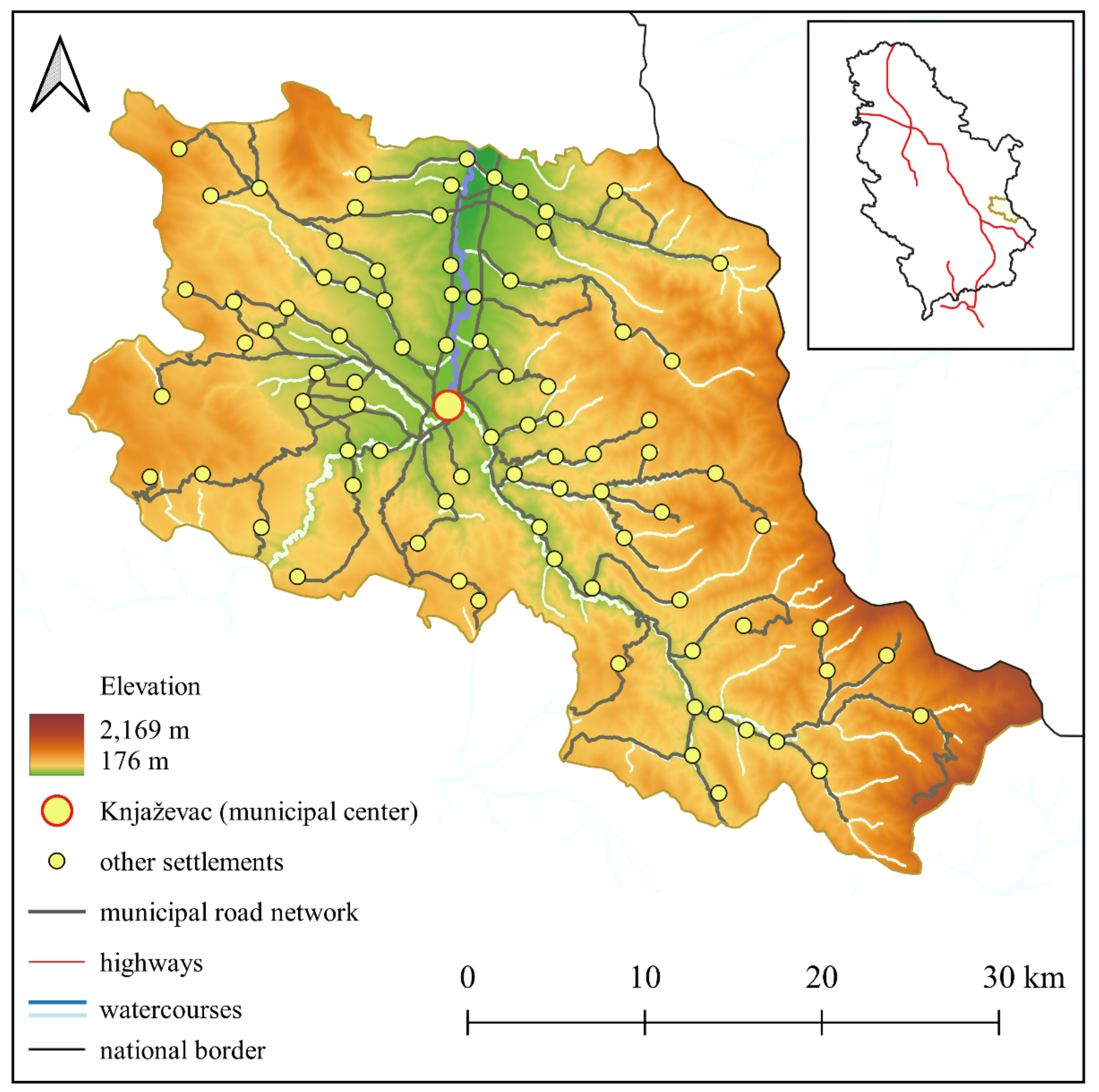
Figure 2.
Spatial plans in the Planning and Building Act and the Law on the Planning System. Source: Authors’ interpretation.
Figure 2.
Spatial plans in the Planning and Building Act and the Law on the Planning System. Source: Authors’ interpretation.
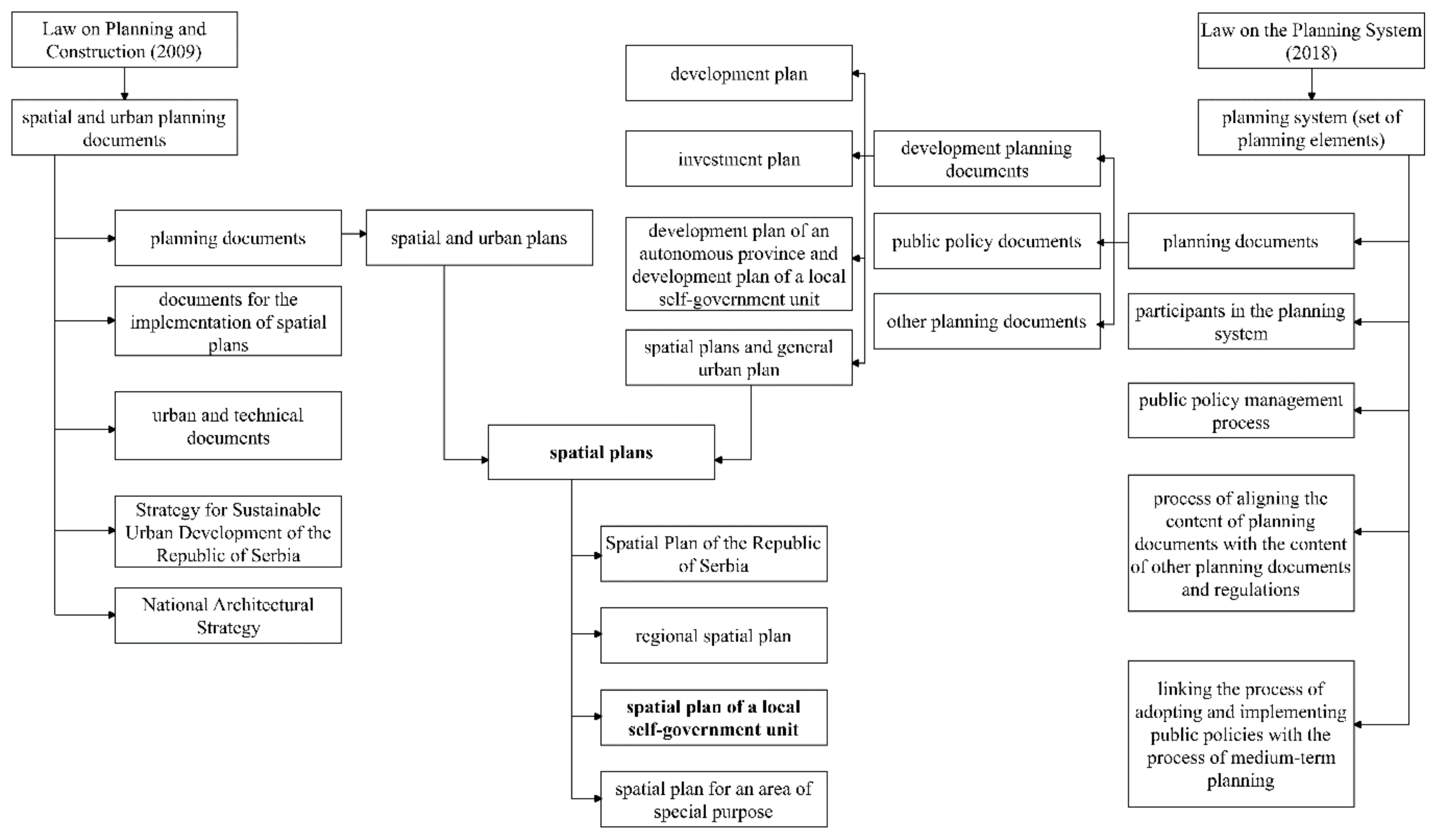
Figure 3.
The study area and the spatial distribution of PHC facilities. Source: Authors’ interpretation.
Figure 3.
The study area and the spatial distribution of PHC facilities. Source: Authors’ interpretation.
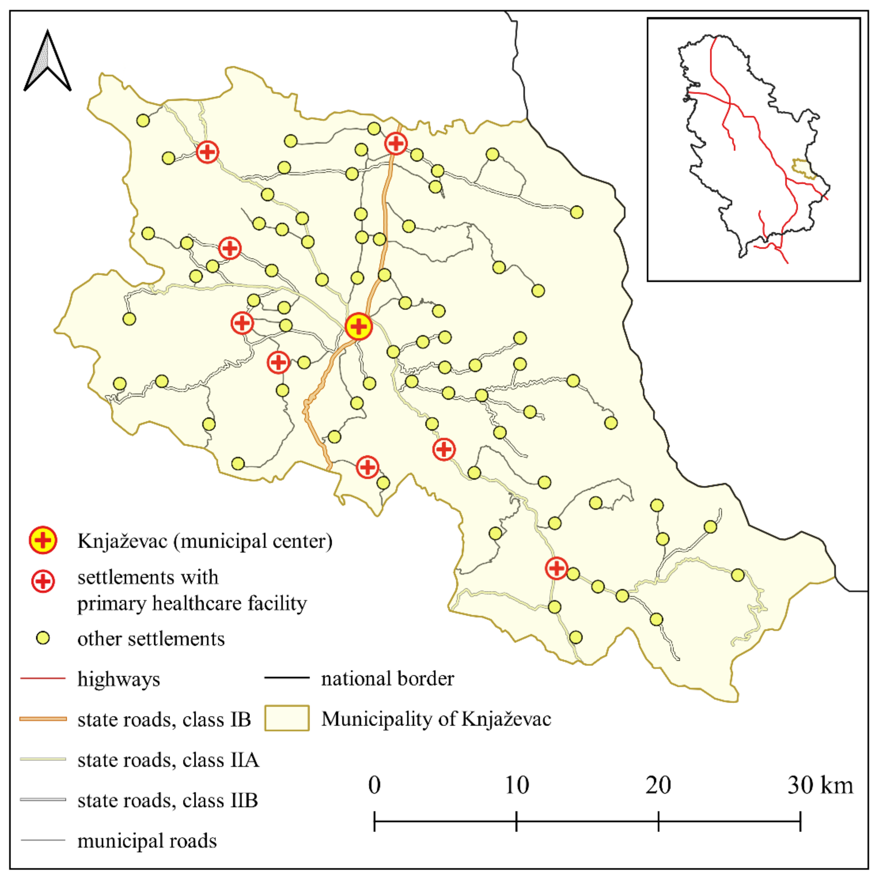
Figure 4.
The operation logic of the p-median location-allocation model. Source: Authors’ interpretation.
Figure 4.
The operation logic of the p-median location-allocation model. Source: Authors’ interpretation.
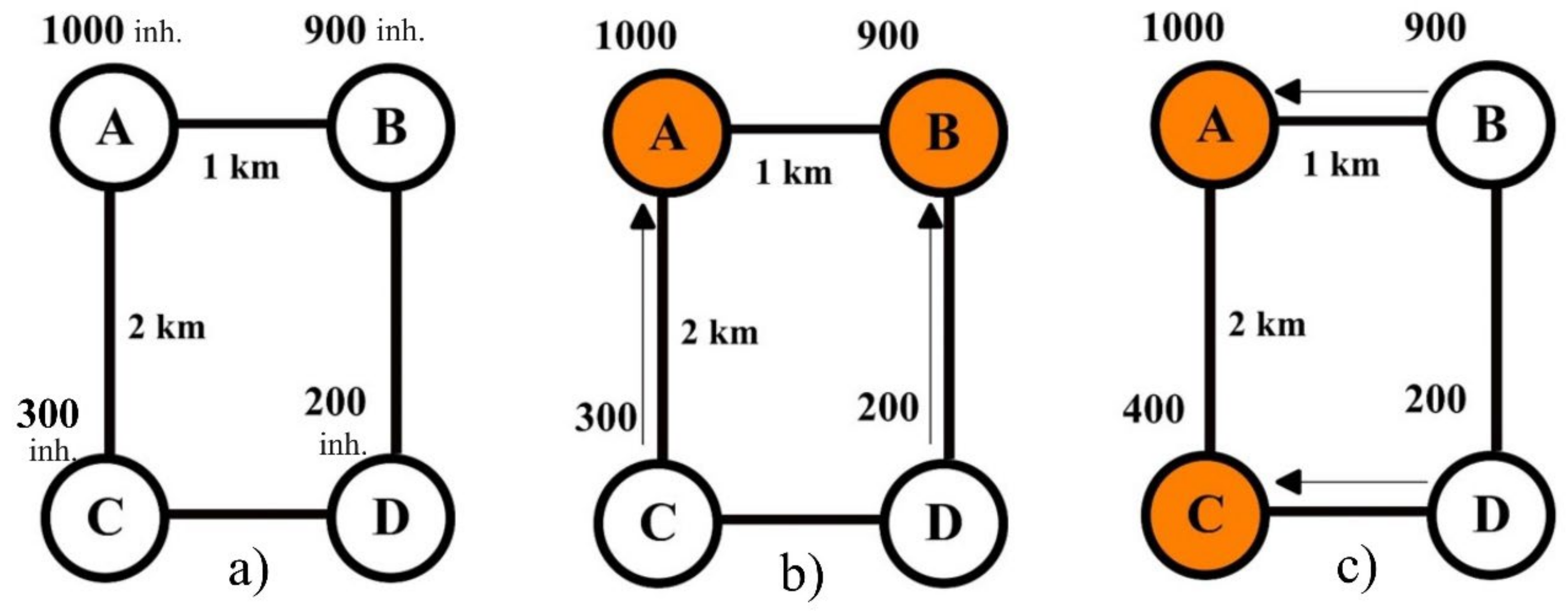
Figure 5.
The spatial organisation of the PHC facility network a) in 2002 and 2011, b) in 2022, c) in 2030 without facility closure, d) in 2030 with one facility closed, e) in 2030 with two facilities closed, and f) in 2030 with three facilities closed. Source: Authors’ interpretation.
Figure 5.
The spatial organisation of the PHC facility network a) in 2002 and 2011, b) in 2022, c) in 2030 without facility closure, d) in 2030 with one facility closed, e) in 2030 with two facilities closed, and f) in 2030 with three facilities closed. Source: Authors’ interpretation.
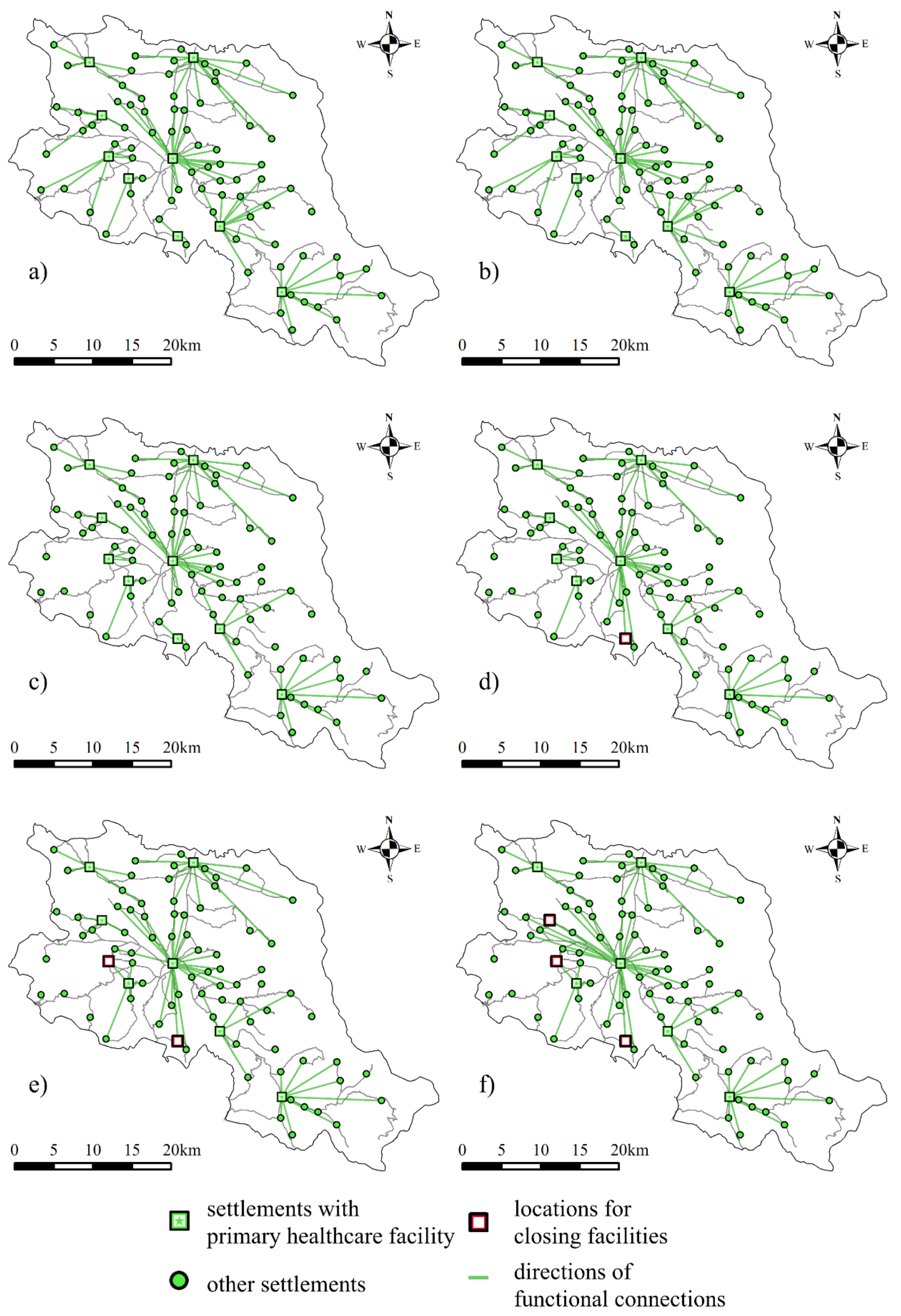
Figure 6.
Average accessibility7 to PHC facilities in the Municipality of Knjaževac. Source: Authors’ interpretation.
Figure 6.
Average accessibility7 to PHC facilities in the Municipality of Knjaževac. Source: Authors’ interpretation.
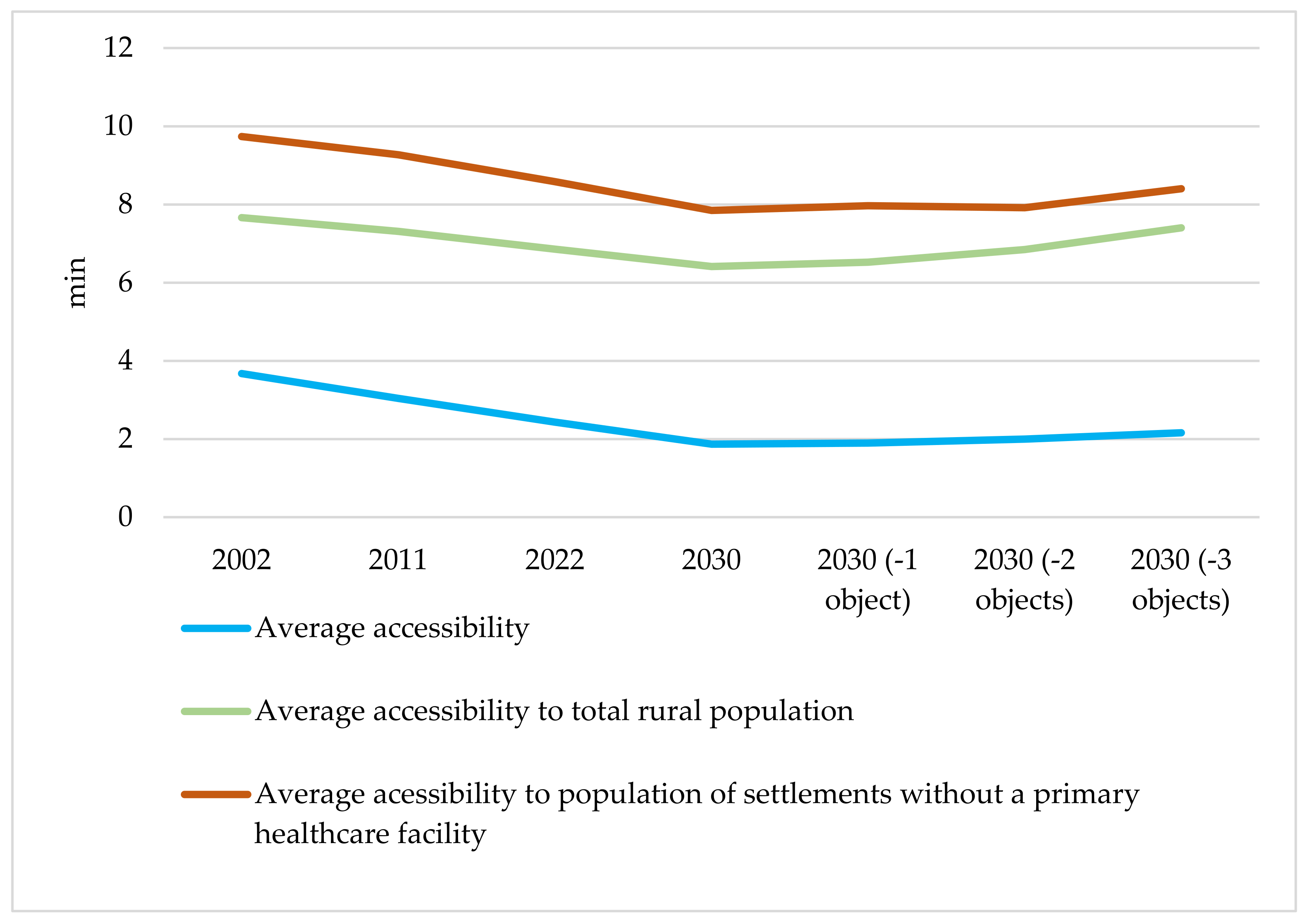

Table 1.
The spatial organization problem of the PHC facility network within the classification of location problems. Source: Authors’ interpretation.
Table 1.
The spatial organization problem of the PHC facility network within the classification of location problems. Source: Authors’ interpretation.
| Static/dynamic problem | In the local context and practice in Serbia, the spatial organisation of the PHC facility network (at the level of the local self-government unit) is viewed as a segment of the spatial plan for the local self-government unit.4 It is based on the specific number and spatial distribution of inhabitants and the facilities serving them, within the real (existing or planned) road network in a given area. In temporal terms, it focuses on the current state, with projected needs for specific services according to expected changes (projections) of the population size of that area within the (approximate) planning horizon. In this respect, it is static in nature, i.e., focused on a specific moment (typically the present or the planning horizon), which makes it a static problem. The focus on the expected state in the future will be achieved in this research by projecting the number of inhabitants of the settlements in the Municipality of Knjaževac for 2030. |
| Continuous/discrete (network) problem | As the modelling is based on the real spatial distribution of users within the existing transportation network, assuming that the existing settlements are the only logical sites where facilities can be located, this is a discrete (network) problem. |
| Locating a single or multiple facilities | As a rule, this is a system with multiple facilities. |
| Presence/absence of capacity constraints | Keeping in mind that the network of rural settlements in the Municipality of Knjaževac (as well as in the vast majority of municipalities and cities in Serbia) consists of rural settlements with a small population, capacity constraints of facilities are not considered a significant issue. In other words, the fundamental question is whether and how PHC services are accessible to a specific group of users (settlement). |
| Location, allocation and location-allocation problem | Hypothetically, keeping in mind the specific on-site situation, our case can be discussed in the context of all three types. However, the location-allocation problem, which addresses the simultaneous locating (or closing) of multiple facilities (where the locations of a certain number can be predetermined, i.e., corresponding to existing facilities) and allocating their users, emerges as the only suitable option. |
| Qualitative and quantitative approaches to problem solving | The basic weights of settlements are expressed in quantitative terms (the number of users or residents). A qualitative approach can be applied in parallel by introducing a thresholds or a criterion (e.g., not locating a service facility in settlements where the population is smaller than a specified number of residents; locating a facility in every settlement that has a primary school, etc.). |
| One-echelon and multi-echelon problem | The networks of PCH facilities in the spatial organisation at the local level are typically single-echelon systems. |
| Hub location problem | In the hub location model, demands are defined as interactions between nodes, whereas in the spatial organisation of PHC facility networks, the basic relationship is between facilities and users. Therefore, these models are not relevant in this respect. |
| Single-criterion / multi-criterion problem | Generally speaking, the spatial organisation of PHC facility networks can be planned taking into account one or more different criteria. The criterion of maximizing accessibility is the only criterion to consider as the striving to ensure equitable accessibility to PHC facilities is one of the key objectives for improving this service. |
| Median, centre and anticentre problem | Generally speaking, the spatial organisation of the PHC facility network can be planned through the prism of all three problem types. The selection of the appropriate one is explained below. |
| 1 | According to the Law on Public Services (Government of the Republic of Serbia, 1991) public services include institutions, enterprises and other forms of organisation established by the law, performing the activities and tasks that ensure the exercise of citizens’ rights and needs of citizens in the areas of education, research, culture, physical culture, student and pupil standards, healthcare, social protection, child welfare, social security, animal healthcare, etc. |
| 2 | Local self-government units in Serbia are among the largest in Europe, with an average area of 530 km² and approximately 45,000 inhabitants. |
| 3 | This theory failed to gain broader recognition in scholarly circles until the 1950s, and it was first published in English as late as 1966 (Bradford and Kent, 1977). |
| 4 | Although the concepts of planning and plan are closely related, it is rightly emphasised that these are different logical categories: planning is a process, which means that it is ongoing and dynamic in nature, while a plan is an image of a desired or projected state, which means that it is static in nature (Doderović and Ivanović, 2013). Accordingly, the spatial plan of a local self-government unit is a static document (subject to changes through fairly infrequent amendments and changes), with a relatively short planning horizon (usually 10–15 years). |
| 5 | The apparent difference between the classification of the main models and the problem classification presented in previous sections and Table 1 (median, centre and anticentre problem) additionally illustrates that it is impossible to classify them so as to cover all relevant aspects. More specifically, the median problem corresponds to the p-median location-allocation model, as is the case with the centre problem and the minimax location-allocation model. The anticentre problem, typically used to locate landfills, hazardous material storage, etc., or facilities where location is based on maximising distance from the nearest user, is therefore excluded from further consideration in this research. |
| 6 | This number of facilities is proportional to the population decrease in the municipality between 2011, when the current spatial plan of the Knjaževac Municipality was adopted (it defined the existing network of these facilities), and 2030. |
| 7 | The values include travel in both directions. |
Disclaimer/Publisher’s Note: The statements, opinions and data contained in all publications are solely those of the individual author(s) and contributor(s) and not of MDPI and/or the editor(s). MDPI and/or the editor(s) disclaim responsibility for any injury to people or property resulting from any ideas, methods, instructions or products referred to in the content. |
© 2024 by the authors. Licensee MDPI, Basel, Switzerland. This article is an open access article distributed under the terms and conditions of the Creative Commons Attribution (CC BY) license (http://creativecommons.org/licenses/by/4.0/).
Copyright: This open access article is published under a Creative Commons CC BY 4.0 license, which permit the free download, distribution, and reuse, provided that the author and preprint are cited in any reuse.


