

Submitted:
16 June 2024
Posted:
19 June 2024
Read the latest preprint version here
Abstract
Springs play a significant role in maintaining hydrological balance in the mountain ecosystem. The communities living in the mountain tops rely entirely on spring water for their daily needs. In recent decades, spring water discharges have decreased drastically in the Himalayan regions and become seasonal. Remote sensing and geographical information system techniques have proved to be essential for understanding the sustainable development of groundwater, particularly where people rely solely on spring water in the mountainous regions of the Himalayas. This study employs the Analytical Hierarchy Process (AHP) to identify groundwater potential zones. It involves overlaying seven thematic layers concerning elements of physical features and land-use/land-cover of the region, using the weighted overlay toolbox in ArcGIS, with each layer being assigned a weight based on its importance. Based on the results, groundwater potential zones have been classified into five categories: poor, fair, good, very good, and excellent. The study found that poor groundwater potential zones cover 1.1% of the area, fair zones cover 27.8%, good zones cover 23.3%, very good zones cover 26.6%, and excellent zones cover 21.2% of the total area. The excellent to very good potential zones are associated with perennial springs that have higher discharge (4.30-30.92 l/m), lineaments, rainfall, forested land, and porous soils, favoring the potentiality of the springs. The fair and poor groundwater potential zones are associated with seasonal flowing springs, consisting of barren land, less rainfall, and low fracture density are influencing the potentiality groundwater. The validation of the groundwater potential zones indicated an Area Under Curve (AUC) value of 0.88, which shows good agreement with observed spring water locations. The identified groundwater potential zones are valuable for prioritizing the area for the sustainable development of spring water. Particularly, it is helpful for the stakeholder departments to involved in developing strategies for sustainable water management at the micro-watershed level and safeguarding spring water resources using integrated watershed management.
Keywords:
Springs
; Khulgad Micro watershed
; AHP
; Lineaments
; Groundwater potential zone.
1. Introduction
Groundwater proves to be an invaluable and priceless natural resource essential for various human activities, such as drinking water supply, industrial processes, and irrigation. Accounting for about 34% of the Earth’s freshwater, it forms the largest freshwater resource in the world and immensely important for society (23, 64). Therefore, understanding this precious resource in a particular territory is necessary for supporting sustainable development.
The Sustainable Development Goal Six (SDG-6) of the United Nations aims to ensure universal access to clean drinking water adequate sanitation, and improved hygiene, recognizing them as essential rights for all individuals by 2030 (66). Setting up this kind of target is a dire necessity in the ongoing unsustainable practices in the world, which are not only leading to quantitative reduction of surface water but also have made direct use of this water harmful for human beings, inviting various diseases. Further, the pace of rapid modernization, industrialization, and intensive agricultural practices induced by high population growth has also led to the shortage and increase in the demand for clean drinking water in both rural and urban areas (18). Organic and heavy metal contamination has accumulated in surface waterways due to excessive and uncontrolled use, lowering the water’s quality. Meanwhile, global problems like drought and climate change have had a disastrous effect on surface water, sometimes entirely destroying it.
These above-mentioned factors have led to humans’ dependency on groundwater to satisfy their daily needs. Subsequently, the agriculture sector accounts for the largest utilization of the groundwater resource in the world, i.e., around 42% of the world’s available groundwater, followed by household consumption for safe drinking water supply ranging between 25 % to 50% globally (71, 65). However, the proportion varies between country to country depending upon the level of development and the needs of the population. Of the Indian population, 85% relies on groundwater for drinking purposes. And about 40-60 % of water supply provisions are met with groundwater (5, 6). In rural Bangladesh, tube-wells are the primary source of potable water (22). In several rapidly developing sub-Saharan African nations, including Burkina Faso, the Central African Republic, South Sudan, Ethiopia, Chad, Nigeria, Somalia, and Uganda, groundwater serves as the primary water source for drinking around 70% to 90% of the local people (25, 12). In the United States, 38% of the population counts on groundwater for the purpose of drinking, sourced either from private wells or public systems, with self-supply wells catering to nearly 13% of the population (43, 34). In Nigeria, the dependency on groundwater is so high that only 20% of the Lagos population are provided with a piped utility water supply (15). With respect to agricultural consumption, approximately half of India’s irrigation activities rely on groundwater, making it one among world’s largest water consumers. In China, around 9 million hectares of land are irrigated using groundwater (30).
In all over the India around five million springs are reported among those three millions are in the Indian Himalayan regions, and these are experiencing depletion or seasonal fluctuation, attributed to diverse factors such as human interventions and the consequences of climate change (71,54). The decline in spring water availability can also be linked to rising temperatures, heightened rainfall intensity, altered temporal distribution, and a notable decrease in winter precipitation (58).
The drying of springs is increasingly recognized as a critical issue in the Himalayan region, with a notable decline in spring discharge being documented across various areas. Reports from Uttarakhand indicate a significant reduction in spring flow (4,29). Research conducted by (33), as well as (63), highlights severe water shortages due to the declining discharge of the springs, particularly during dry seasons. (8) observed a decline of over 30% in spring discharge over the past 30 years in Nepal’s mid-hill region. Additionally, about 50% of perennial springs in the Indian Himalayas have either turned out to be dry or become seasonal (53). In addition, the transformation of about 82% of the spring fed streams of the upper Kosi river from perennial to non-perennial over the last twenty-five years is a critical issue (57). This drastic change has significantly reduced the lean flow of these rivers, creating serious challenges for the sustainability of the rivers and the communities that depend on them. Consequently, the local inhabitants are experiencing water shortages for drinking and irrigation, putting their livelihoods and the well-being of their livestock at risk.
The declining rate of ephemeral springs is notably faster than that of perennial springs in the Himalayan area (51). Consequently, understanding and managing the Himalayan region’s spring systems is challenging and crucial. Therefore, Evaluating the capacity and productivity of springs in the Himalayan region is essential given the rugged terrain, considerable variations in elevation, and dense forest cover (54). The potential of springs indicates the probability of their presence in regions with adequate water resources, which is essential for estimating groundwater productivity. And in order to access the potentiality of springs, potentiality of groundwater has to be assessed, as it is the major source of water for continuous flowing of springs. For this purpose, remote Sensing (RS) and Geographic Information System (GIS) methods serve as efficient and cost-effective tools for generating valuable data on different geological layers, aiding in the interpretation of potential groundwater zones (36,42,45,46,47,48). RS techniques serve as a significant source of information regarding the correlation among slopes, landforms, land use, and lineaments. This data can act as an attribute in GIS and then overlaid with additional datasets (46, 72).
Many investigators have utilized RS and GIS techniques to recognize potential groundwater zones by employing diverse thematic layers, including lineaments, geology, drainage density, geomorphology, and soil maps (10,16,32,38,40,47,61). However, the validations of groundwater potential zone maps with geology, landuse/cover, spring discharge and lineaments in the watershed scale are not explored sufficiently.
Therefore, the present study attempts to delineate groundwater potential zones with the help of Remote sensing and GIS techniques in the micro watershed of the Kosi basin. The results have been evaluated with the field-observed spring flow data and density of springs in different parts of the study area. The coherence of the results of the identified potential zones with spring flow reveals that the remote sensing and GIS tool can be used to find out potential zones of spring and would be helpful to prepare strategies for the poor zones.
2. Study Area
The Khulgad catchment is situated within the Kosi watershed, located in the Lesser Himalayan terrain of India’s Almora district, within Uttarakhand State (Figure 1). Covering an area of approximately 33 km², the catchment’s elevation ranges from 1080 m to 2140 m. The Syahidevi peak, locally known as the “water tower” of the Khulgad watershed, represents the highest point, contributing significantly to the area’s water resources. The drainage pattern of the catchment trails a dendritic pattern, with some abrupt diversions noted in major drainage channels due to faults traversing the watershed (50). Geomorphologically, the area comprises 24 types of fluvial, pluvial, and tectonic landforms (50, 56).
The predominant land use/land cover in the area encompasses dense and semi-dense forests, primarily located in the southern and western parts of the watershed. Forested areas, mainly comprising oak and pine, cover approximately 52.2% of the total area, while barren land occupies 30.2%, agricultural land 13.7%, and urban areas 3.9%. The majority of the Khulgad watershed features shallow soil depths ranging from 25 to 55 cm, with sandy loam covering 50% of the area and the basin’s outlet identified as sandy clay loam.
The annual average rainfall in the basin ranges from approximately 980 mm in August to around 8.2 mm in November. Summer monsoon rains contribute approximately 75% of the total annual rainfall. The Khulgad watershed falls within a cool temperate climate region, with an annual average temperature of 20.3°C. The average maximum temperature was recorded as 26.7°C, and the minimum average temperature recorded was 15.3°C, respectively.
3. Hydrological and Geological Setting
The Khulgad catchment is situated within the northeast-dipping southern limb of the synclinal Almora Nappe, characterized by a thick folded sheet of Precambrian metamorphic rocks and associated granites (50). Extensively studied by various researchers (20,35,50,67) the geological map reveals six lithological units within the basin.
Augen gneisses formation covers approximately 18.8% of the area, predominantly comprising sheared and fractured gneiss formations in the southwestern part of the watershed (50). These gneisses, pushed southward upon underlying schist and quartzite, have undergone extensive crushing, resulting in the development of secondary porosities that enhance permeability and form aquifers.
Garnetiferous mica schist, jointed quartzite, and friable quartzite, covering 18.8%, 28%, and 8% of the region respectively, form the underlying geological layers. Biotite schist and phyllite, constituting 15% and 8% of the watershed respectively, comprise the bottom layers (Figure 1b). Hydrogeologically, the area is characterized by aquifers of secondary porosity, primarily consisting of faults, fractures, and joints. Structural geology plays a crucial role in understanding the characteristics of springs and groundwater in the region. The Sitalakhet thrust passing over the Salla, Naula, and Dhamas schist and quartzite formations is particularly significant, as it contributes to the formation of secondary porosity, making this zone a potential aquifer. The gneissic rock in the thrust region has become highly permeable due to the formation of fractures and joints, underlain by gougy clay acting as an impermeable layer. Consequently, the thrust areas of Sitalakhet, Salla, Champa, Naula, and Syahidevi hills form clusters of springs. The discharge of these springs is primarily dependent on rainfall and its variability, with climate change emerging as a crucial factor influencing the quantity and quality of Himalayan springs, sustaining their flow throughout the year.
4. Materials and Methods
The remote sensing and GIS techniques are implemented to understand the spring water potential zone mapping in the micro watershed of Khulgad, for that a detailed methodology was developed (Figure 2.). Various maps such as lineament density, slope, drainage density, rainfall, and lithology map clubbed to create a groundwater potential map, The occurrence of groundwater is significantly influenced by hydrological conditions, which are primarily determined by these thematic layers. These layers serve as a dependable foundation for accurately predicting the groundwater potential of a given area (68).
4.1. Preparation of Thematic Maps
4.1.1. Lineaments Extractions
The linear features are lineaments that are straight structural features visible on the surface of the earth, often referred to as significant “lines of landscape” (21). The geological or geomorphic processes are primarily the cause of these discontinuities (11). The methodology employed in this study involves the analysis of various geospatial datasets to assess groundwater potential and hydrological characteristics within the study area. Firstly, linear features on the Earth’s surface are identified using hillshade techniques based on the Digital elevation model (DEM) with azimuth angles of 30o,35o, 40o, and 45o. On the other hand, the linear features were automatically generated using Geomatica software with a sentinel-2B multispectral images dataset. In this we utilize automated feature extraction tools available in Geomatica software to detect linear features in the imagery. These tools typically use algorithms based on edge detection, pattern recognition, or spectral analysis to identify potential lineaments. The lineaments generated from the remote sensing techniques were compared with an existing lineament map (NRSC-IRS-P6 LISS-3 FCC) of the area to validate the linear features in the study region.
The Lineament Density (LD) is calculated using equation (1) by dividing the total length of all identified lineaments by the area of interest.
where ΣLi total length of the entire lineaments in km and the “A” is the grid area in km2.
The total length of all lineaments (ΣLi) in kilometers is divided by the area of each grid in square kilometers to compute the lineament density value for all grids. The calculated value is then outlined at the corresponding center of the grid, and these values aid in generating the lineament density map using interpolation.
4.1.2. Drainage Density Analysis
Drainage density is a crucial metric used in hydrology to understand the distribution and characteristics of stream channels within a given area, typically measured in kilometers of channel length per square kilometer of drainage basin area (km/km²). It serves as an indicator of how closely spaced the stream channels are and provides insights into the nature of the surface materials. The drainage density is calculated based on the equation (2).
where Σ Di is the overall stream length (km), and “A” is the area of the grid (km2).
Drainage density serves as a crucial indicator inversely related to permeability, thus holding significance in assessing groundwater potential (60). In regions characterized by low drainage density, there is a higher potential for infiltration, as highlighted by (62), leading to the formation of favorable groundwater zones (13,32) compared to areas with high drainage density.
4.1.3. Slope and Land Use Analysis
The Slope, defined as the rate of change of elevation across a surface, finds a significant role in determining the movement of superficial water flow, primarily influenced by gravitational forces (14). A slope map of the area under study was created from Advanced Land Observing Satellite Phased array–type L-band synthetic aperture radar (ALOS PASAR) DEM with 12 m resolution using ArcGIS 10.5 software. In this study, the slopes are characterized into five classes, very low, low, moderate, high, and very high in degree.
The land use/land cover (LULC) mapping holds great importance in remote sensing as it plays a crucial role in the development of groundwater resources. LULC directly influences various hydrogeological processes within the water cycle, such as infiltration, evapotranspiration, and surface runoff. Additionally, surface cover characteristics, like roughness, have a significant impact on discharge rates, with rougher surfaces generally leading to increased infiltration and reduced runoff.
For this study, land use and land cover are created based on the sentinel-2B optical imagery having 10m spatial resolution, each land use is created based on supervised classification with field verification.
4.1.4. Lithology and Soil Analysis
The lithology map was generated through field surveys and validated according to Rai, 1993 Ph.D. thesis. The study area encompasses various geological formations, including augen gneiss, garnetiferous schist, schist, quartzite, and phyllite. Each lithological unit possesses unique characteristics influencing its ability to facilitate water infiltration from precipitation. Consequently, specific weightages were assigned to each lithology in weighted overlay method in the arc GIS based on its infiltration capabilities.
The Soil map was downloaded from the (https://soilgrids.org/) website with a 200cm standard depth. The study area consists of three types of soil classes such as chernozems, leptosols, and luvisols. Among chernozems, and luvisols, the leptosols are generally considered to be the most porous soil. Leptosols are characterized by their shallow depth and often have a high proportion of coarse fragments, such as gravel or rock fragments, within the soil profile. This coarse texture and shallow nature typically result in good drainage and high porosity, allowing water to infiltrate easily into the soil. Therefore, Leptosols tend to have higher porosity compared to Chernozems and Luvisols, making them more conducive to groundwater recharge and infiltration. Consequently, Specific weights were given to each soil in the weighted overlay method in the arc GIS based on its infiltration capacity.
4.1.5. Rainfall Map Preparation
Rainfall being the primary source of recharge, as indicated by previous studies (32,60), governs the volume of water accessible for infiltration into the groundwater system, thus holding significant importance in this study’s hydrological analysis (2). Daily rainfall data spanning 14 years (2010–2023) were obtained from the Indian Meteorological Department (IMD) for all existing weather stations in and around the study area. The precipitation data is interpolated with two stations in the study area using Arc GIS 10.5.
4.1.6. Delineation of Groundwater Potential Zones
The groundwater potential zone map (GPM) for the study area was created by combining five different thematic maps using ArcGIS 10.5. The integration was conducted by summating the overall groundwater influencing factors. The following formula (3), derived from previous studies (27,37,47), was employed:
Here, GPM represents the groundwater potential map, MC1 to MC5 denote the chief criteria from the thematic layer maps, (w) signifies the weight assigned to each thematic map, SC1–SC5 indicate the sub-criteria of each thematic layer map, and (r) represents the ranking of the sub-criteria.
4.2. Analytic Hierarchy Process (AHP)
Each thematic layer map underwent classification, with ranks assigned to various features within each theme. The normalized weights of these features are detailed in Table 1 (9,31).
4.3. Validation of the Analysis
The validation process of the data involves several steps to ensure its accuracy and reliability. For the lineament data, field observations play a crucial role in validating the detected features. Field survey was carried out to verify the presence and characteristics of lineaments identified through remote sensing techniques. Additionally, lineament maps are utilized as reference documents to cross-validate the detected lineaments with known geological features and structures. This comprehensive validation approach helps confirm the accuracy of the lineament data and enhances confidence in its interpretation.
Regarding the groundwater potential map, validation is primarily conducted through field observations of observed spring discharge. Field surveys are conducted to locate and document natural spring water discharge within the study area. The locations of these observed springs are then compared with the groundwater potential map to assess its reliability in categorizing areas with high groundwater potential. If the mapped groundwater potential zones correspond well with the observed spring with higher discharge in the field, it provides validation of the accuracy and effectiveness of the groundwater potential map. On the other hand, the groundwater potential zone map was assessed using the Receiver Operating Characteristic (ROC) curve and the Area Under the Curve (AUC) metrics. The ROC curve, which ranges from 0.5 to 1.0, is used to estimate the model’s accuracy. Specifically, the AUC value stipulates a single measure of overall model performance. An AUC value of 0.5 indicates that the model performs no better than random chance, while values closer to 1.0 indicate higher model accuracy. It plots the True Positive Rate (TPR) against the False Positive Rate (FPR) equation (4,5) (41,49). This validation process helps ensure that the map provides reliable information for groundwater resource management and decision-making purposes.
This validation process helps ensure that the map provides reliable information for groundwater resource management and decision-making purposes.
5. Results
5.1. Soil Map
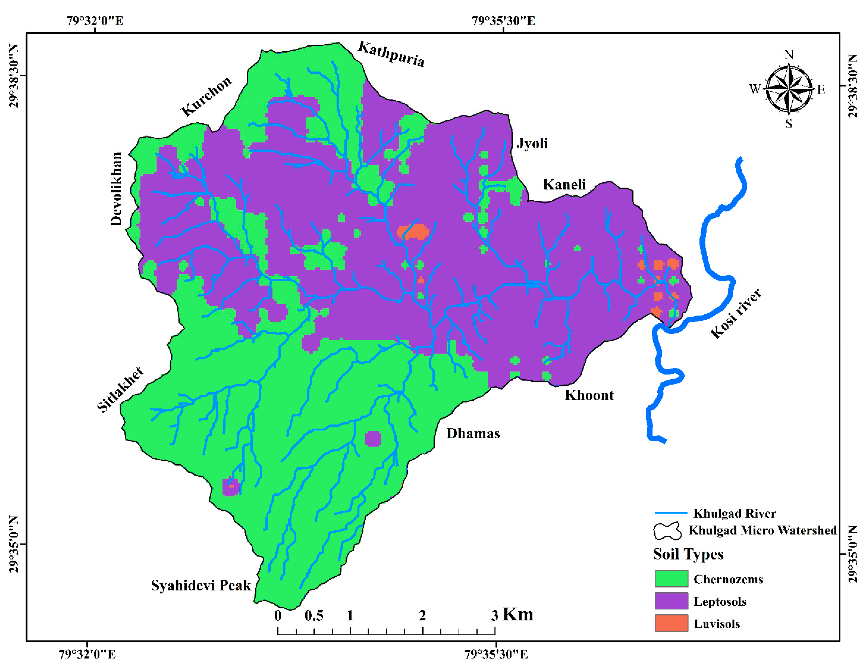
The study area exhibits three types of soil classes, namely chernozems covering 15.3km2, leptosols covering 17.4km2, and luvisols covering only 0.17km2. Among these three types, leptosols are considered to be the most porous. They are characterized by their shallow depth and high proportion of coarse fragments such as gravel or rock fragments within the soil profile. This results in good drainage, high porosity, and easy water infiltration into the soil. Consequently, 53% of the study area is covered by leptosols, making them more conducive to groundwater recharge and infiltration. On the other hand, chernozems cover around 47% of the area and luvisols are present in a very small area around 0.5%. Therefore, understanding the soil types is essential for understanding the groundwater potentiality of the study area.
Figure 3.
Soil type map of the study area.
5.2. Lithology Map
The lithology map delineates several geological formations within the study area, including Augen gneiss covering an area of 5.4 km2, devolikhan quartzite spanning 2.04 km2, Garnetiferous schist extending over 9.29 km2, Dhaili phyllite occupying 2.68 km2, Dhamas quartzite encompassing 9.02 km2, Muscovite schist covering 0.31 km2, and Kathpuria schist spanning 0.77 km2 (Figure 4). These geological formations exhibit secondary porosity, facilitating the transmission of groundwater (Figure 10). The southwestern region of the area hosts the gneissic rock, characterized by chernozems (organic black soil) in the topsoil layer and dense and semi-forested vegetation cover, suggesting a favorable environment for groundwater availability. Garnetiferous schist predominates below the gneissic rock, which covers 28.2% of the study area with a rank of two due to its low porous and permeable nature; however, these rocks have higher secondary porosity, such as fractures, which can hold a good amount of water (50). While Dhamas quartzite is the second most abundant rock type found in the eastern part of the region covering an area of 27.4% with very low porosity nature, on the other hand this area stabilizes the groundwater potentiality by the influence of secondary porosity, soil type, and land use.
5.3. Lineament Density Map
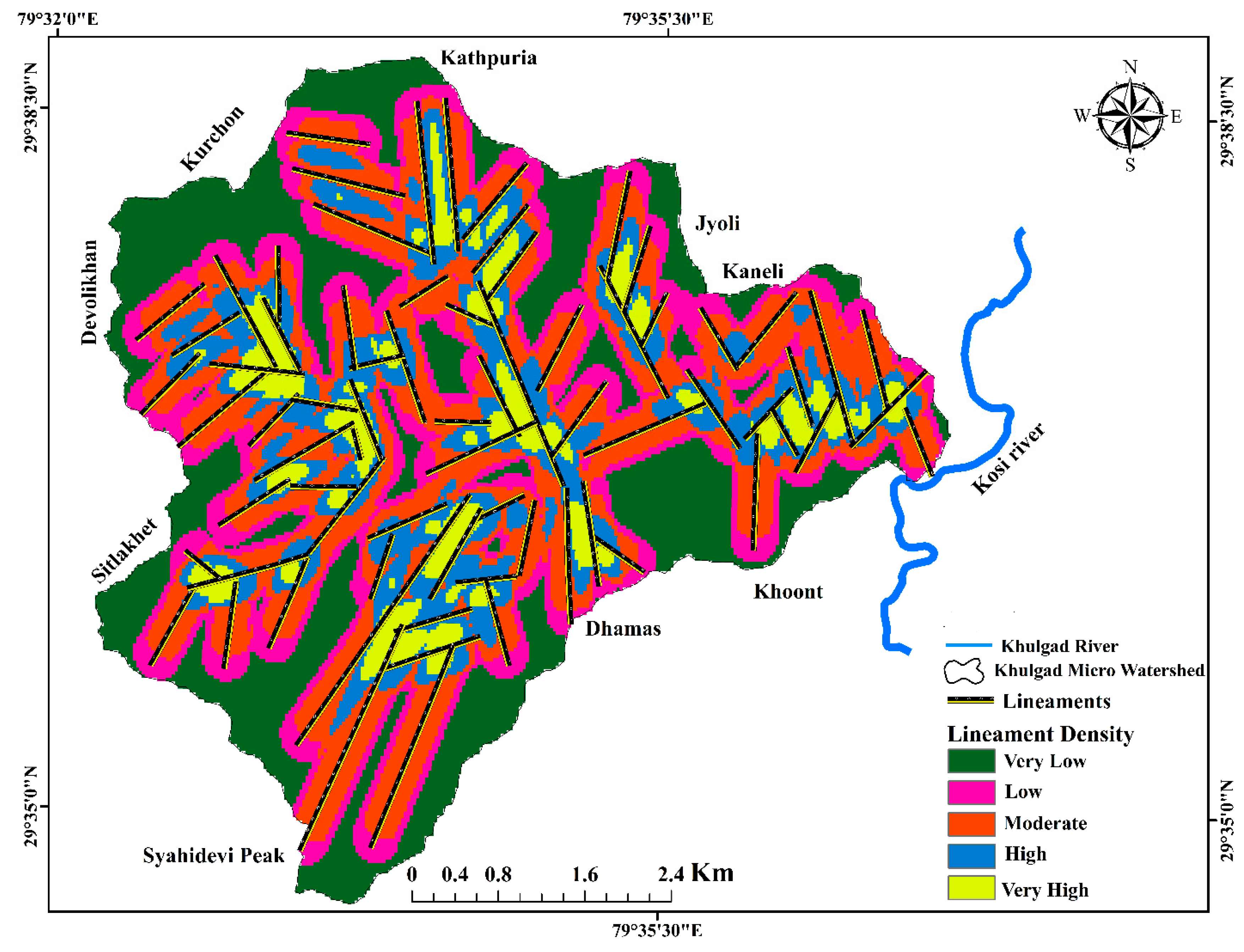
Lineament density map of the Khulgad watershed has been grouped into five categories (Table 1), each representing the intensity of fractures or joints in the region. Rank one indicates a very low intensity of lineaments, while rank five represents a very high intensity. The smallest area covered is rank one with 8.66 km², followed by rank two with 5.9 km². Rank three has the highest area of coverage with 9.94 km², while rank four constitutes 5.55 km². The lineament density between rank three and five has a higher chance of groundwater potential than one and two. However, it is completely dependent on the aquifer properties. Based on the potentiality of groundwater, the very high groundwater potential area covers around 8.8% of the total area, the high groundwater potential area covers about 16.8% of the total area, the moderate groundwater potential area covers approximately 30.1%, the low groundwater potential area covers 17.9%, and the very low groundwater potential area covers around 26.3% of the total study area.
Figure 5.
Lineament density map of the study area.
5.4. Drainage Density Map
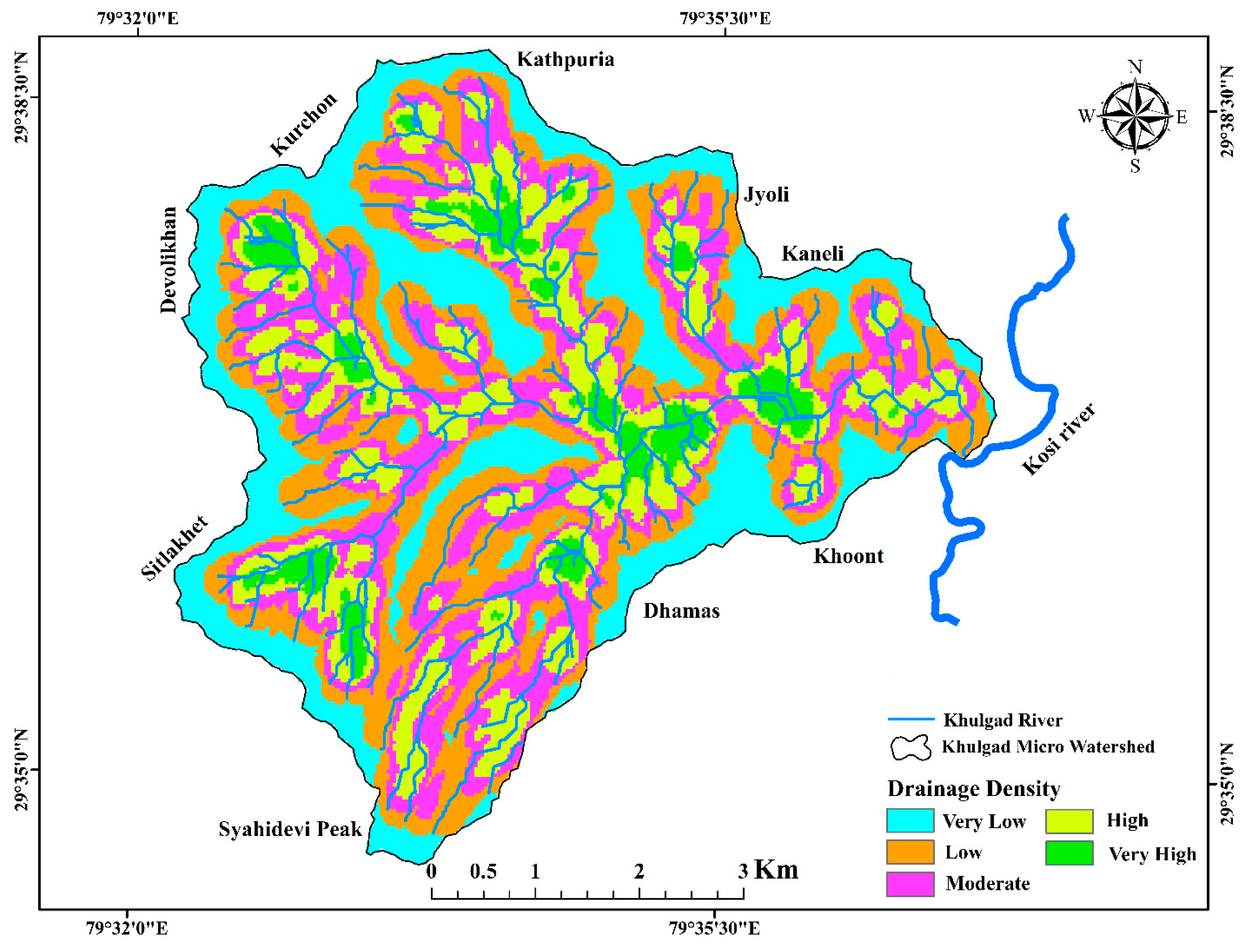
The drainage density of the watershed is determined by the availability of a maximum number of channels present in that area. In this particular study, the drainage density has been categorized into five ranks based on the density of the drainages, similar to the lineament density. The highest drainage density has been given to rank five, covering an area of 2.0 km2, while the least groundwater availability area has been assigned to the weighted rank of one, consisting of an area of 8.26 km2. However, 48.7% of the study area shows evidence of moderate to very high groundwater capability, while the remaining 51.3% indicates very low to low groundwater potential based on the density of the drainage. The majority of the groundwater potential zone is located in the southwestern and central parts of the watershed.
Figure 6.
Shows the drainage density map of the study area.
5.5. Land Use and Land Cover
The map of land use/ land cover comprises seven different categories of land use, which are dense forest, semi-dense forest, agricultural land settlements, roads, barren land, water bodies, and built-up area. Each type of land use has been given a weightage based on its capacity to retain groundwater. The highest weighted ranks of five have been assigned to dense and semi-dense forests, respectively. On the other hand, the lowest ranking has been given to roads and barren land, as per Table 1. The total area covered by forested area is 17.1 km2, out of which 2.1 km2 is dense forest, 3.3 km2 is agricultural land, 10.3 km2 is barren land, 0.6 km2 is water body, 1.2 km2 is roads, and 0.4 km2 is built-up area. However, the entire 17.2 km2 area of forested land in the southwestern part of the study area shows great potential for groundwater (Figure 7).
5.6. Slope Map
The slope forms a crucial topographic parameter that indicates how steep or gentle the terrain is (14). The spacing between the contours can help determine the slope. The contours are closely spaced in a terrain, indicating a steeper slope, whereas broadly spaced contours suggest a gentle slope. In an elevation output raster, each cell is assigned a slope value. Lower slope angle values signify flatter terrain, while higher slope angle values denote steeper areas. The slope is measured by determining the maximum rate of change in elevation from each cell to its neighboring cells. These slope values can be expressed either in percentages or degrees and can be calculated in both vector and raster formats.
The slope analysis reveals that elevation decreases from the northern part to the central and eastern parts of the area, with slopes ranging from 0º to 10º in both flat and mountainous regions, respectively. In areas with nearly level slopes (0-10 degrees), surface runoff is slow, giving more time for rainwater to percolate, thus creating zones with good groundwater potential. Conversely, in regions with steep slopes (31-60 degrees), runoff is rapid, reducing the time rainwater stays on the surface and consequently bringing about lower infiltration rates. This results in poor groundwater potential, particularly in the northeastern part of the study area, which is marked by high to very high slopes. The slope map is categorized into five distinct classes, as illustrated in (Figure 8).
5.7. Rainfall Map
The map shows the annual average rainfall of the study area, with a weighted rank of one to five assigned for low to high rainfall. The highest rainfall is observed in the southwestern part of the study area, with an annual average of 970 to 980mm. The lowest annual average rainfall has been identified in the eastern part of the study area, with only 960mm and a comparatively low groundwater potential zone. Based on the annual average rainfall (as shown in Figure 9), the highest groundwater potential zone has been identified in the southwestern part of the study area.
5.8. Validation of Groundwater Potential Zones
The potential groundwater zone has been verified through field observations of the springs and the existing lineament map (NRSC-IRS-P6 LISS-3 FCC) in order to validate the groundwater potential zones in the study area. Measurements of the discharge of spring water were taken in the field to validate the groundwater potential zone in the area. In this study, among the total springs the 50% of the perennial springs are located in the excellent and very good groundwater potential area, 15% of the springs are in the good groundwater potential zone, and the remaining 35% are in the fair to poor groundwater potential area. Among the 35%, 10% are in the poor groundwater potential zone with conclusive evidence like the presence of ephemeral and low discharge springs are clustered together. Apart from that, the springs are primarily connected to lineament features or fractures, and those with higher discharge are more closely associated with these features. The springs that appear seasonal flowing are mostly found in areas with fair to poor groundwater potential zones this zones are covered around 29% of the study area remaining 71 % of the study area are in the good to excellent groundwater potential zone. This indicates that the analysis made in this study is supported by the available field evidence. The AUC 0.88 value indicates the model performance is good with the observed spring water in the study area.
Figure 10.
Groundwater potential zone map with Spring discharge.
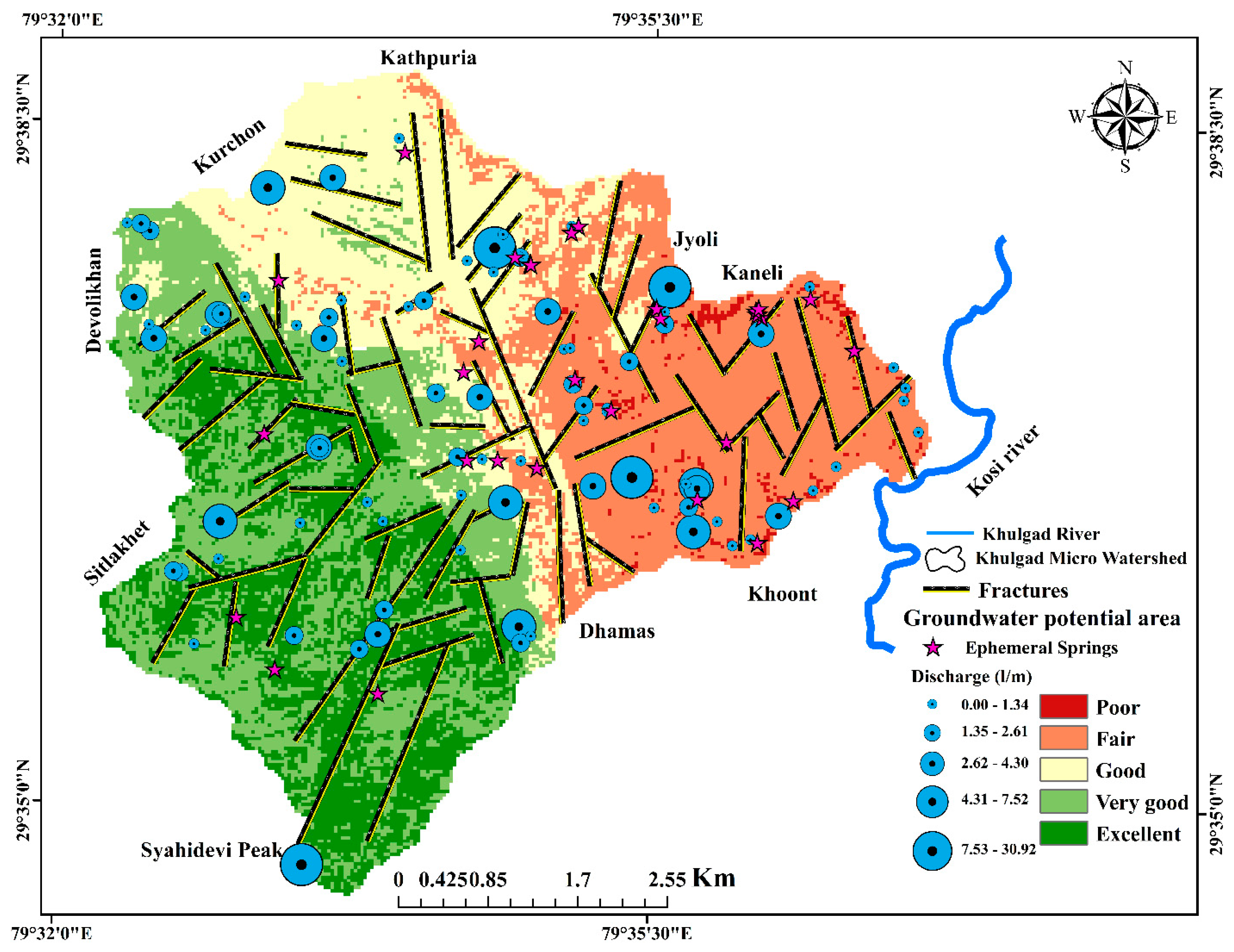
Figure 11.
The model validation using ROC curve with observed spring and potential map.
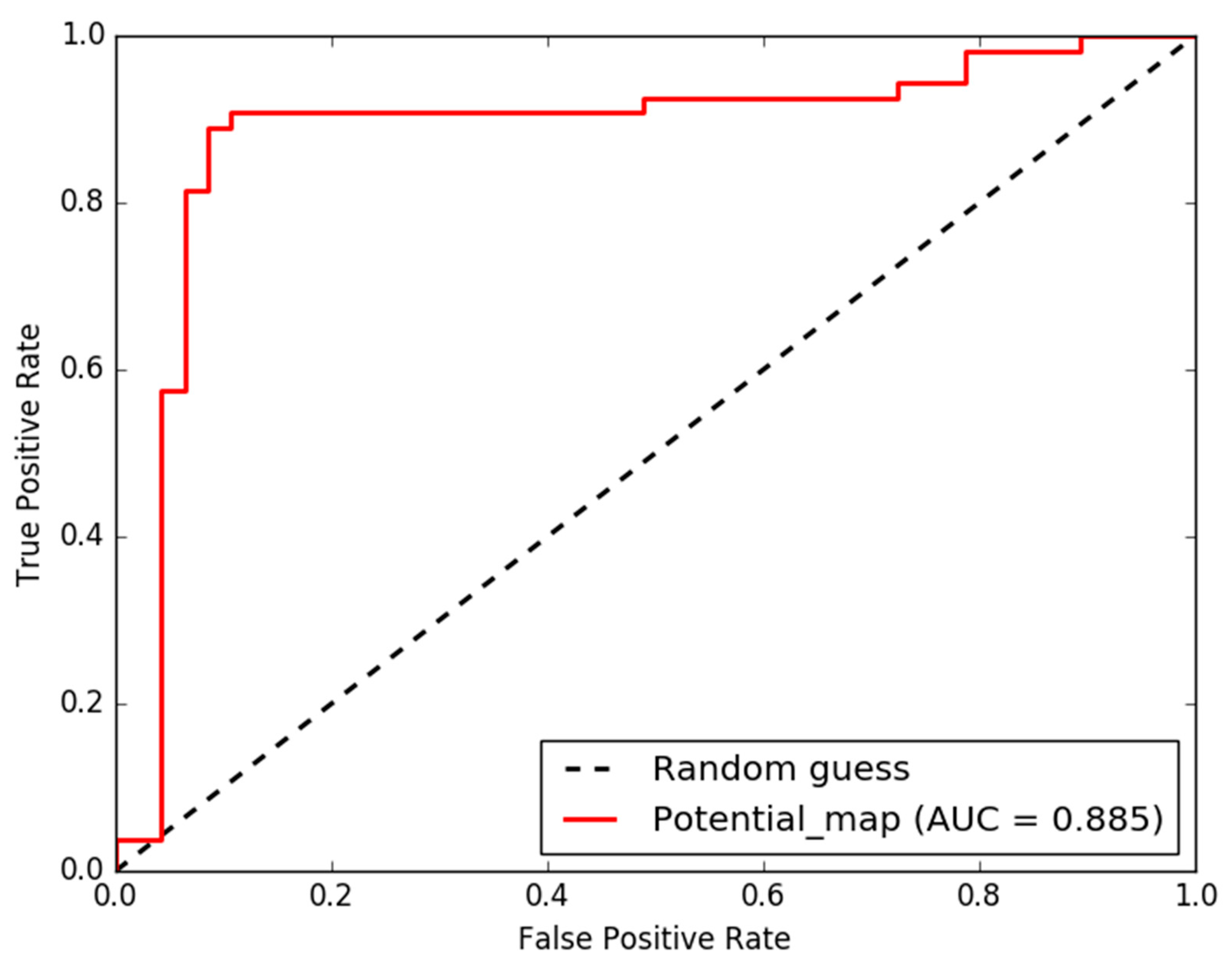

Table 2.
Various thematic layers showing the percentage of groundwater potential area and its respective rank.
Table 2.
Various thematic layers showing the percentage of groundwater potential area and its respective rank.
| Themes | Potentiality for Groundwater Storage |
Assigned Rank | % Area |
|---|---|---|---|
| Land use and land cover | Very High (Dense forest) | 5 | 45.1 |
| High (Forested land) | 5 | 6.5 | |
| High (Agricultural land) | 4 | 19.0 | |
| Low (Buildup area) | 2 | 10.0 | |
| Very low (Road) | 1 | 1.4 | |
| Moderate (Barren land) | 3 | 16.3 | |
| High (Water body) | 4 | 1.7 | |
| Lineament density (km2) | Very low | 1 | 26.3 |
| Low | 2 | 17.9 | |
| Moderate | 3 | 30.1 | |
| High | 4 | 16.8 | |
| Very high | 5 | 8.8 | |
| Drainage density (km2) | Very low | 1 | 25.0 |
| Low | 2 | 26.2 | |
| Moderate | 3 | 23.3 | |
| High | 4 | 19.2 | |
| Very high | 5 | 6.2 | |
| Slope (degrees) | Very high | 5 | 13.9 |
| High | 4 | 29.0 | |
| Moderate | 3 | 30.3 | |
| Low | 2 | 20.0 | |
| Very low | 1 | 6.9 | |
| Geology | Moderate (Augen gneiss) | 3 | 16.4 |
| Low (Schist) | 2 | 0.9 | |
| Moderate (Daili phyllite) | 3 | 8.1 | |
| Low(Garnetiferous schist) | 2 | 28.2 | |
| Very low (Quartzite) | 1 | 27.4 | |
| Very low (Devolikhan quartzite) | 1 | 6.2 | |
| Kathpuria schist | 2 | 10.3 | |
| Soil | Very High (Leptosole) | 5 | 52.8 |
| Moderate (Luvisole) | 3 | 0.5 | |
| Moderate (Chernozems) | 3 | 46.5 | |
| Rainfall (mm) | Very low | 1 | 25.2 |
| Low | 2 | 14.9 | |
| Moderate | 3 | 17.4 | |
| High | 4 | 18.4 | |
| Very high | 5 | 24.0 |
6. Discussion
The mapping of groundwater potential zones is crucial to understanding the extent of groundwater resources in a given area. The parameters considered for mapping depend on specific conditions in the particular region. Therefore, in this study, different thematic layers such as slope, lineament density, lithology, drainage density, rainfall, soil, and land use-land cover have been prepared to identify the groundwater potential zone mapping as used by the earlier workers (3,26,70,69,7,54,74). Each thematic layer is designated a weight based on the local field conditions. In the Khulgad micro watershed, seven thematic layers were used to identify the groundwater potential zone. For instance, understanding the lithology is crucial for determining the water-holding capacity of rocks in the secondary porosity (28). In the study area, the gneissic rock in the southwestern part exhibits the majority of secondary porosity, as confirmed by field observations. Therefore, it has been assigned the highest rank for this study. In the Himalayan regions, groundwater potentiality is influenced by secondary porosity (39,17). Linear features in the watershed suggest that hard rock terrains transmit more water due to the presence of secondary porosity. In this study, lineaments are digitized from the satellite imagery (IRS-P6 LISS-3 FCC), for the lineament analysis however, we used combined lineaments of both hill shade lineaments and field surveyed lineaments to understand the groundwater potentiality of the area (Figure 5.)
The rainfall is also an important parameter in this study, as several researchers consider it crucial for groundwater potential zone mapping (10,24,59). Therefore, the higher rainfall in the study area is concentrated in the southwestern part. The potentiality of the groundwater zone depends not only on rainfall, but also on the aquifer system’s holding capacity, slope, and soil. In the Khulgad micro watershed, the slope is considered vulnerable and has less residence time to infiltrate rainfall into the aquifer system. About 13.9% of the area has a very high degree of slope (>30 degree), indicating low groundwater potential compared to other regions. However, the lowest slopes (0-10°, 10-17°, 17-23°) are mainly located in the southwestern part of the study area, which has the highest potential. However, the northern part of the watershed (Kathpuria, Kurchon, Kaneli) regions show higher steep slopes >30 degrees indicates that less groundwater potential. Similar studies explored the impact of slopes on groundwater recharge in the Himalayas. It revealed that steep slopes (>30 degrees) were linked to lower groundwater potential because of quick runoff and limited infiltration. On the other hand, slopes less than 15 degrees were associated with higher groundwater recharge potential (52,55). The soil, land use/land cover, and drainage density, confirm the groundwater potential area has been spread across the western part of the Khulgad micro watershed based on the frequency of the drainage, soil porosity and permeability, and intensity of the forest.
The validation of the groundwater potential zones using RS and GIS with field observed data is always challenging for researchers. In a study conducted by (54), observed perennial and seasonal springs were used to confirm the groundwater potential area of the Eastern Himalayas. Our current study followed similar approaches to substantiate groundwater potential zones. However, we considered the occurrence, distribution, discharge of the spring, and density of the perennial springs to validate the groundwater potential zones. The validation revealed that about 50% of the perennial springs in the study area are located in excellent and very good groundwater potential zones. Hence, this part of the basin is made up of fractured rocks of Gneiss, Quartzite, thick soil cover, and forested land use land cover. All these conditions are favorable for the high recharge in this part of the basin. Additionally, the ROC curve was employed further to justify the groundwater potential areas. Similarly, ROC curve methods were used by various researchers to validate the groundwater potential zone mapping (19,44). The groundwater potential-related works are typically validated using observed well yield and other available water resources of those particular study regions (60). Groundwater potential studies are increasingly valuable for the sustainable development of groundwater, particularly in headwater regions that heavily rely on groundwater resources.
7. Conclusions
The Khulgad micro-watershed in the Kosi basin has been analyzed to identify potential groundwater available zones. The results show that 48% of the area in the southwestern part of the watershed has excellent to very good groundwater potential, preeminently in the highly forested, low slope with a higher frequency of fracture areas where most springs are perennial. However, 23.5 % of the seasonal or dried-up springs match with poor to fair groundwater potential zones. The lineaments are mostly found in areas with very good to excellent groundwater potential, and the springs found along these lineaments are showing perennial with excellent discharge. The AHP method has predicted values with an 88% accurate ROC curve, indicating good model performance. Overall, the mapping of the groundwater potential zone in the micro-watershed of the Kosi basin in the lesser Himalayan regions is accurate based on observed springs. This study will be valuable for policymakers and government agencies for managing spring water and groundwater availability in the Himalayan regions.
Author Contributions
Nijesh P: Conceptualization, Methodology, Validation, Investigation, Writing, original draft. Neeraj Pant: Data curation, Methodology, Validation, Investigation, Writing, original draft. Anant: Data curation, Methodology, Validation, Investigation, Writing, review & editing. Abhinav Patel: Conceptualization, Writing, review & editing. Abhinesh Kumar Singh: Investigation, Writing, review & editing. Sury, Raju: Data curation, Methodology, Investigation, Writing, original draft. Shive Prakash Rai: Conceptualization, Writing, Validation, Investigation, review & editing. Radha, Meera: Writing, review & editing.
Funding
No funding has been received from any agency for this research work.
Data Availability Statement
The data will be made available on request.
Acknowledgments
The authors would like to express their gratitude to Banaras Hindu University and the Head of the Department of Geology, B.H.U. for their valuable support. This study is a part of Mr. Nijesh’s Ph.D. thesis. The research work would not have been possible without the support of the local villagers in Khulgad, especially Mr. Bhupal Singh, who helped us locate the springs.
Conflicts of Interest
The authors affirm that they have no known financial or interpersonal conflicts that would have appeared to have an impact on the research presented in this study.
References
- Abdelkareem, M.; Abdalla, F.; Alshehri, F.; Pande, C.B. Mapping Groundwater Prospective Zones Using Remote Sensing and Geographical Information System Techniques in Wadi Fatima, Western Saudi Arabia. Sustainability 2023, 15, 15629. [Google Scholar] [CrossRef]
- Adiat, K.A. N.; Nawawi, M.N. M.; Abdullah, K. Assessing the accuracy of GIS-based elementary multi criteria decision analysis as a spatial prediction tool–a case of predicting potential zones of sustainable groundwater resources. Journal of Hydrology 2012, 440, 75–89. [Google Scholar] [CrossRef]
- Adnan, N.A.; Atkinson, P.M. Exploring the impact of climate and land use changes on streamflow trends in a monsoon catchment. International journal of climatology 2011, 31, 815–831. [Google Scholar] [CrossRef]
- Agarwal A, Bhatnagar NK, Nema RK, et al. Rainfall dependence of springs in the Midwestern Himalayan hills of Uttarakhand. Mountain Research and Development 2012, 32, 446–455. [Google Scholar] [CrossRef]
- Alam, M.F.; Foster, S. (2009) Policy priorities for the boom in urban private wells. Pp 54-57.
- Ali, S.; Fakhri, Y.; Golbini, M.; Thakur, S.K.; Alinejad, A.; Parseh, I. ... & Bhattacharya, P. Concentration of fluoride in groundwater of India: a systematic review, meta-analysis and risk assessment. Groundwater for Sustainable Development 2019, 9, 100224. [Google Scholar]
- Al-Shabeeb, A.R.; Hamdan, I.; Al-Fugara, A.K.; Al-Adamat, R.; Alrawashdeh, M. Spatial mapping of water spring potential using four data mining models. Water Supply 2023, 23, 1743–1759. [Google Scholar] [CrossRef]
- Chapagain, P.S.; Ghimire, M.; Shrestha, S. Status of natural springs in the Melamchi region of the Nepal Himalayas in the context of climate change. Environment, Development and Sustainability 2019, 21, 263–280. [Google Scholar] [CrossRef]
- Chowdary, V.M.; Chakraborthy, D.; Jeyaram, A.; Murthy, Y.K.; Sharma, J.R.; Dadhwal, V.K. Multi-criteria decision making approach for watershed prioritization using analytic hierarchy process technique and GIS. Water resources management 2013, 27, 3555–3571. [Google Scholar] [CrossRef]
- Chowdhury, A.; Jha, M.K.; Chowdary, V.M.; Mal, B.C. Integrated remote sensing and GIS-based approach for assessing groundwater potential in West Medinipur district, West Bengal, India. International Journal of Remote Sensing 2009, 30, 231–250. [Google Scholar] [CrossRef]
- Clark, C.D.; Wilson, C. Spatial analysis of lineaments. Computers & Geosciences 1994, 20, 1237–1258. [Google Scholar]
- Danert, K.; Theis, S. (2017). Professional Management of Water Well Drilling Projects and Programmes Online Course 2018; Report for Course Participants. UNICEF-Skat Foundation Collaboration, 2019.
- Dinesh Kumar PK, Gopinath, G. , Seralathan, P. Application of remote sensing and GIS for the demarcation of groundwater potential zones of a river basin in Kerala, southwest cost of India. Int J Remote Sens 2007, 28, 5583–5601. [Google Scholar] [CrossRef]
- Ettazarini, S. Groundwater potentiality index: a strategically conceived tool for water research in fractured aquifers. Environmental Geology 2007, 52, 477–487. [Google Scholar] [CrossRef]
- Foster, S. The key role for groundwater in urban water-supply security. Journal of Water and Climate Change 2022, 13, 3566–3577. [Google Scholar] [CrossRef]
- Ganapuram, S.; Kumar, G.V.; Krishna, I.M.; Kahya, E.; Demirel, M.C. Mapping of groundwater potential zones in the Musi basin using remote sensing data and GIS. Advances in Engineering Software 2009, 40, 506–518. [Google Scholar] [CrossRef]
- Ghimire, M.; Chapagain, P.S.; Shrestha, S. Mapping of groundwater spring potential zone using geospatial techniques in the Central Nepal Himalayas: a case example of Melamchi–Larke area. Journal of Earth System Science 2019, 128, 26. [Google Scholar] [CrossRef]
- Gnanachandrasamy, G.; Zhou, Y.; Bagyaraj, M.; Venkatramanan, S.; Ramkumar, T.; Wang, S. Remote sensing and GIS based groundwater potential zone mapping in Ariyalur District, Tamil Nadu. Journal of the Geological Society of India 2018, 92, 484–490. [Google Scholar] [CrossRef]
- Guru, B.; Seshan, K.; Bera, S. Frequency ratio model for groundwater potential mapping and its sustainable management in cold desert, India. Journal of King Saud University-Science 2017, 29, 333–347. [Google Scholar] [CrossRef]
- Heim, A. Central Himalaya. Denkschr. Schweiz. Naturforsch. Ges. 1939, 73, 1–245. [Google Scholar]
- Hobbs, WH. Lineaments of the Atlantic border region. Geol. Soc. Am. Bull. 1904, 15, 483–506. [Google Scholar] [CrossRef]
- Hoque, S.F.; Hope, R.; Arif, S.T.; Akhter, T.; Naz, M.; Salehin, M. A social-ecological analysis of drinking water risks in coastal Bangladesh. Science of The Total Environment 2019, 679, 23–34. [Google Scholar] [CrossRef]
- Islam, F.; Tariq, A.; Guluzade, R.; Zhao, N.; Shah, S.U.; Ullah, M. ... & Aslam, M. Comparative analysis of GIS and RS based models for delineation of groundwater potential zone mapping. Geomatics, Natural Hazards and Risk 2023, 14, 2216852. [Google Scholar]
- Jha, M.K.; Chowdary, V.M.; Chowdhury, A. Groundwater assessment in Salboni Block, West Bengal (India) using remote sensing, geographical information system and multi-criteria decision analysis techniques. Hydrogeology Journal 2010, 18, 1713–1728. [Google Scholar] [CrossRef]
- Kebede, S. Groundwater in Ethiopia: features, numbers and opportunities. Springer Science & Business Media. 2022. [Google Scholar]
- Khosravi, K.; Panahi, M.; Tien Bui, D. Spatial prediction of groundwater spring potential mapping based on an adaptive neuro-fuzzy inference system and metaheuristic optimization. Hydrology and Earth System Sciences 2018, 22, 4771–4792. [Google Scholar] [CrossRef]
- Kumar T, Gautam AK, Kumar, T. Appraising the accuracy of GIS multi-criteria decision making technique for delineation of groundwater potential zone. Water Resour Manage 2014, 28, 4449–4466. [Google Scholar] [CrossRef]
- Kumar, R.; Dwivedi, S.B.; Gaur, S. A comparative study of machine learning and Fuzzy-AHP technique to groundwater potential mapping in the data-scarce region. Comput. Geosci. 2021, 155, 104855. [Google Scholar] [CrossRef]
- Kumar, V.; Sen, S. Evaluation of spring discharge dynamics using recession curve analysis: a case study in data-scarce region, Lesser Himalayas, India. Sustainable Water Resources Management 2018, 4, 539–557. [Google Scholar] [CrossRef]
- Li, P.; Qian, H.; Wu, J. Conjunctive use of groundwater and surface water to reduce soil salinization in the Yinchuan Plain, North-West China. International Journal of Water Resources Development 2018, 34, 337–353. [Google Scholar] [CrossRef]
- Machiwal, D.; Jha, M.K.; Mal, B.C. Assessment of groundwater potential in a semi-arid region of India using remote sensing, GIS and MCDM techniques. Water resources management 2011, 25, 1359–1386. [Google Scholar] [CrossRef]
- Magesh, N.S.; Chandrasekar, N.; Soundranayagam, J.P. Delineation of groundwater potential zones in Theni district, Tamil Nadu, using remote sensing, GIS and MIF techniques. Geoscience frontiers 2012, 3, 189–196. [Google Scholar] [CrossRef]
- Mahamuni, K.; Kulkarni, H. (2012). Groundwater resources and spring hydrogeology in South Sikkim, with special reference to climate change, climate change in Sikkim patterns, impacts and initiatives.
- Maupin, Molly, A. Summary of estimated water use in the United States in 2015. No. 2018-3035. US Geological Survey, 2018.
- Merh, S.S.; Vashi, N.M. Structure and metamorphism of the Ranikhet area of Almora District, Uttar Pradesh. Indian Mineralogist 1965, 6, 55–66. [Google Scholar]
- Moghaddam, D.D.; Rezaei, M.; Pourghasemi, H.R.; Pourtaghie, Z.S.; Pradhan, B. Groundwater spring potential mapping using bivariate statistical model and GIS in the Taleghan watershed, Iran. Arabian Journal of Geosciences 2015, 8, 913–929. [Google Scholar] [CrossRef]
- Muheeb MA, Rasheed AJ. Evaluation of aquifers vulnerability to contamination in the Yarmouk river watershed, Jordan, based on DRASTIC method. Arab J Geosci 2009, 3, 273–282. [Google Scholar]
- Muralitharan, J.; Palanivel, K. Groundwater targeting using remote sensing, geographical information system and analytical hierarchy process method in hard rock aquifer system, Karur district, Tamil Nadu, India. Earth Science Informatics 2015, 8, 827–842. [Google Scholar] [CrossRef]
- Nag, S. Application of lineament density and hydrogeomorphology to delineate groundwater potential zones of Baghmundi block in Purulia district, West Bengal; J. Indian Soc. Remote Sens. 2005, 33, 521–529. [Google Scholar] [CrossRef]
- Nagarajan, M.; Singh, S. Assessment of groundwater potential zones using GIS technique. Journal of the Indian Society of Remote Sensing 2009, 37, 69–77. [Google Scholar] [CrossRef]
- Naghibi, S.A.; Pourghasemi, H.R.; Pourtaghi, Z.S.; Rezaei, A. Groundwater qanat potential mapping using frequency ratio and Shannon’s entropy models in the Moghan watershed, Iran. Earth Science Informatics 2015, 8, 171–186. [Google Scholar] [CrossRef]
- Nampak, H.; Pradhan, B.; Abd Manap, M. Application of GIS based data driven evidential belief function model to predict groundwater potential zonation. Journal of Hydrology 2014, 513, 283–300. [Google Scholar] [CrossRef]
- National Groundwater Association. NGWA Groundwater Facts. Available online: https://www.ngwa.org/what-is-groundwater/About-groundwater/groundwater-facts (accessed on 3 February 2024).
- Paul, S.; Roy, D. Geospatial modeling and analysis of groundwater stress-prone areas using GIS-based TOPSIS, VIKOR, and EDAS techniques in Murshidabad district, India. Modeling Earth Systems and Environment 2023, 10, 121–141. [Google Scholar] [CrossRef]
- Pradhan, B. Groundwater potential zonation for basaltic watersheds using satellite remote sensing data and GIS techniques. Central European Journal of Geosciences 2009, 1, 120–129. [Google Scholar] [CrossRef]
- Prasad Jha, M.K.; Chowdhury, A.; Chowdary, V.M.; Peiffer, S. Groundwater management and development by integrated remote sensing and geographic information systems: prospects and constraints. Water resources management 2007, 21, 427–467. [Google Scholar]
- Prasad, R.K.; Mondal, N.C.; Banerjee, P.; Nandakumar, M.V.; Singh, V.S. Deciphering potential groundwater zone in hard rock through the application of GIS. Environmental geology 2008, 55, 467–475. [Google Scholar] [CrossRef]
- Rahmati, O.; Nazari Samani, A.; Mahdavi, M.; Pourghasemi, H.R.; Zeinivand, H. Groundwater potential mapping at Kurdistan region of Iran using analytic hierarchy process and GIS. Arabian Journal of Geosciences 2015, 8, 7059–7071. [Google Scholar] [CrossRef]
- Rahmati, O.; Pourghasemi, H.R.; Melesse, A.M. Application of GIS-based data driven random forest and maximum entropy models for groundwater potential mapping: a case study at Mehran Region, Iran. Catena 2016, 137, 360–372. [Google Scholar] [CrossRef]
- Rai, S.P. (1993) Hydrological and geomorphological studies of the Sya hidevi-Binsar Area, District Almora. Unpublished Ph D thesis, Kumaun University, Nainital, p 160.
- Rai, S.P.; Valdiya, K.S.; Rawat, J.S. Management of water resources: Spring sanctuaries. The Khulgad Project: An Experiment in Sustainable Development, Gyanodaya Prakashan, Nainital, India 1998, 41-60.
- Rajesh, J.; Pande, C.B.; Kadam, S.A.; Gorantiwar, S.D.; Shinde, M.G. Exploration of groundwater potential zones using analytical hierarchical process (AHP) approach in the Godavari River basin of Maharashtra in India. Appl Water Sci 2021, 11, 182. [Google Scholar] [CrossRef]
- Rana, S.; Gupta, V. (2009). Watershed management in the indian himalayan region: issues and challenges. Proceedings of the World Environmental and Water Resources Congress; 2009. [Google Scholar]
- Ranjan, P.; Pandey, P.K.; Pandey, V. Groundwater spring potential zonation using AHP and fuzzy-AHP in Eastern Himalayan region: Papum Pare district, Arunachal Pradesh, India. Environmental Science and Pollution Research 2023, 31, 10317–10333. [Google Scholar] [CrossRef] [PubMed]
- Rao, N.S.; Gugulothu, S.; Das, R. Deciphering artificial groundwater recharge suitability zones in the agricultural area of a river basin in Andhra Pradesh, India using geospatial techniques and analytical hierarchical process method. Catena 2022, 212, 106085. [Google Scholar]
- Rawat, J.S. Database management system for Khulgad WatershedKhulgad micro watershed, Kumaun Lesser Himalaya, Uttarakhand, India. Current Science 2010, 98, 1340–1348. [Google Scholar]
- Rawat, J.S.; Rawat, G. Dying and dwindling of non-glacial fed rivers under climate change (a case study from the upper kosi watershed, central Himalaya, India). Geoecology of Landscape Dynamics 2020, 53–74. [Google Scholar]
- Rawat, S.S.; Jose, P.G.; Rai, S.P.; Hakhoo, N. (2018). spring sanctuary development: sustaining water security in the himalayan region in changing climate.
- Shahid, S. , Nath SK, Ray, J. Groundwater potential modeling in softrock using a GIS. Int J Remote Sens 2000, 21, 1919–1924. [Google Scholar] [CrossRef]
- Shekhar, S.; Pandey, A.C. Delineation of groundwater potential zone in hard rock terrain of India using remote sensing, geographical information system (GIS) and analytic hierarchy process (AHP) techniques. Geocarto International 2015, 30, 402–421. [Google Scholar] [CrossRef]
- Solomon, S.; Quiel, F. Groundwater study using remote sensing and geographic information systems (GIS) in the central highlands of Eritrea. Hydrogeology Journal 2006, 14, 1029–1041. [Google Scholar] [CrossRef]
- Srivastava, P.K.; Bhattacharya, A.K. Groundwater assessment through an integrated approach using remote sensing, GIS and resistivity techniques: a case study from a hard rock terrain. International Journal of Remote Sensing 2006, 27, 4599–4620. [Google Scholar] [CrossRef]
- Tambe, S.; Arrawatia, M.L.; Bhutia, N.T.; Swaroop, B. Rapid, cost-effective and high-resolution assessment of climate-related vulnerability of rural communities of Sikkim Himalaya, India. Current Science 2011, 101, 165–173. [Google Scholar]
- Tariq, A.; Ali, S.; Basit, I.; Jamil, A.; Farmonov, N.; Khorrami, B. ... & Hatamleh, W.A. Terrestrial and groundwater storage characteristics and their quantification in the Chitral (Pakistan) and Kabul (Afghanistan) river basins using GRACE/GRACE-FO satellite data. Groundwater for Sustainable Development 2023, 23, 100990. [Google Scholar]
- Taylor, R.G.; Scanlon, B.; Döll, P.; Rodell, M.; Van Beek, R.; Wada, Y. ... & Treidel, H. Ground water and climate change. Nature climate change 2013, 3, 322–329. [Google Scholar]
- U.N.; 2023. The Sustainable Development Goals Report special edition. United Nations.
- Valdiya, K.S. The two intracrustal boundary thrusts of the Himalaya. Tectonophysics 1980, 66, 323–348. [Google Scholar] [CrossRef]
- Waikar, M.L.; Nilawar, A.P. Identification of groundwater potential zone using remote sensing and GIS technique. International Journal of Innovative Research in Science, Engineering and Technology 2014, 3, 12163–12174. [Google Scholar]
- Wei, A.; Li, D.; Bai, X.; Wang, R.; Fu, X.; Yu, J. Application of machine learning to groundwater spring potential mapping using averaging, bagging, and boosting techniques. Water Supply 2022, 22, 6882–6894. [Google Scholar] [CrossRef]
- Yousefi, S.; Sadhasivam, N.; Pourghasemi, H.R.; Nazarlou, H.G.; Golkar, F.; Tavangar, S.; Santosh, M. Groundwater spring potential assessment using new ensemble data mining techniques. Measurement 2020, 157, 107652. [Google Scholar] [CrossRef]
- Aayog, N.I. T. I. “Inventory and revival of springs in the Himalayas for water security.” Dept. of Science and Technology, Government of India, New Delhi (2017).
- Hinton, J.C. (1996) “GIS and remote sensing integration for environmental applications. ” International Journal of Geographical Information Systems 1996, 10, 877–890. [Google Scholar] [CrossRef]
- Zektser, I.S.; Everett, L.G. (2004). Groundwater resources of the world and their use.
- Zhao, R.; Fan, C.; Arabameri, A.; Santosh, M.; Mohammad, L.; Mondal, I. Groundwater spring potential mapping: Assessment the contribution of hydrogeological factors. Advances in Space Research. 2024. [CrossRef]
Figure 1.
(a) Study area map of Khulgad micro watershed (b) geological cross section.
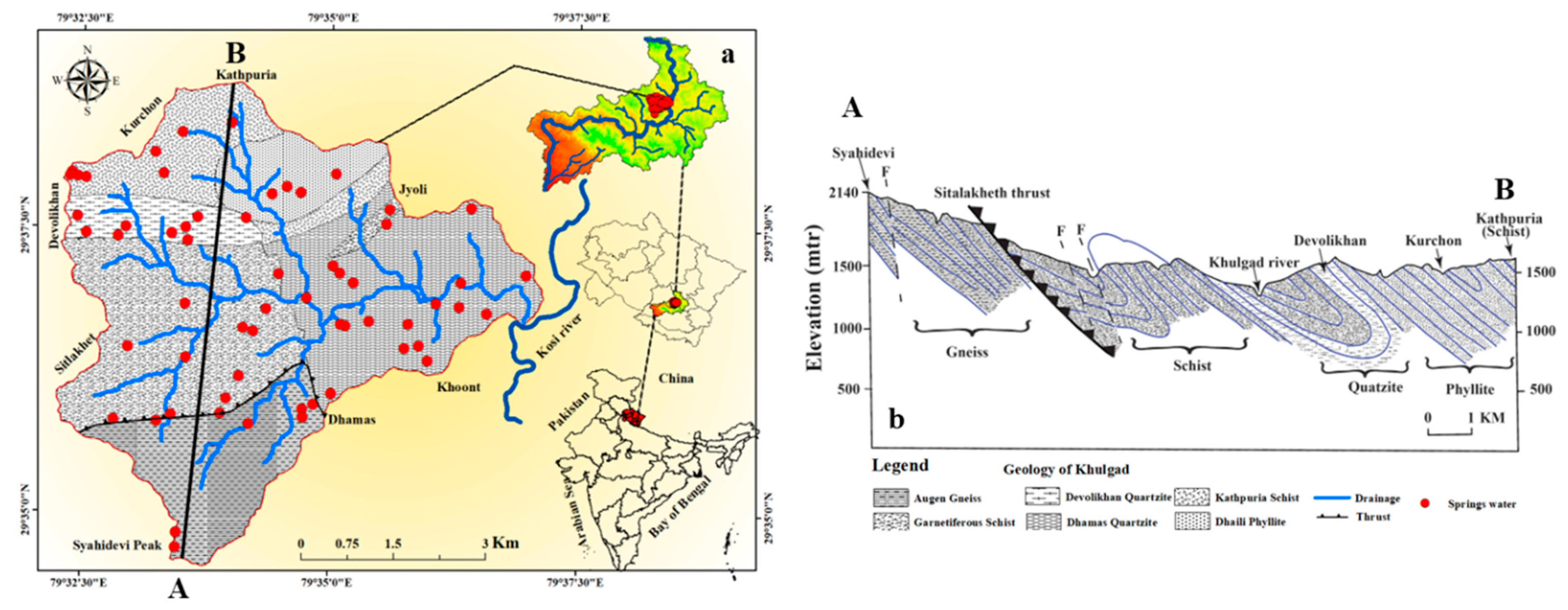
Figure 2.
Methodology developed for the spring water potential zone mapping.
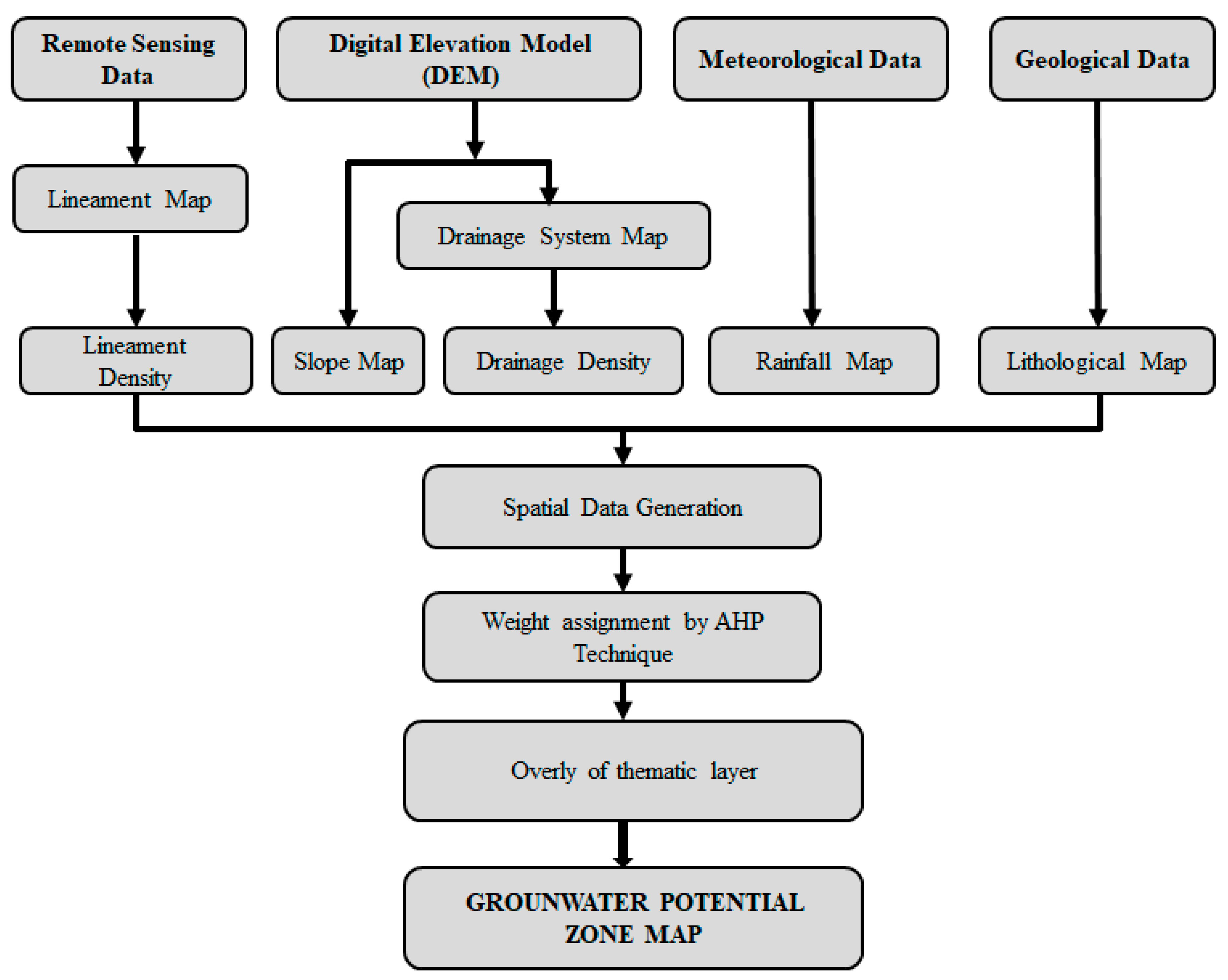
Figure 4.
Lithological map of the Khulgad watershed.
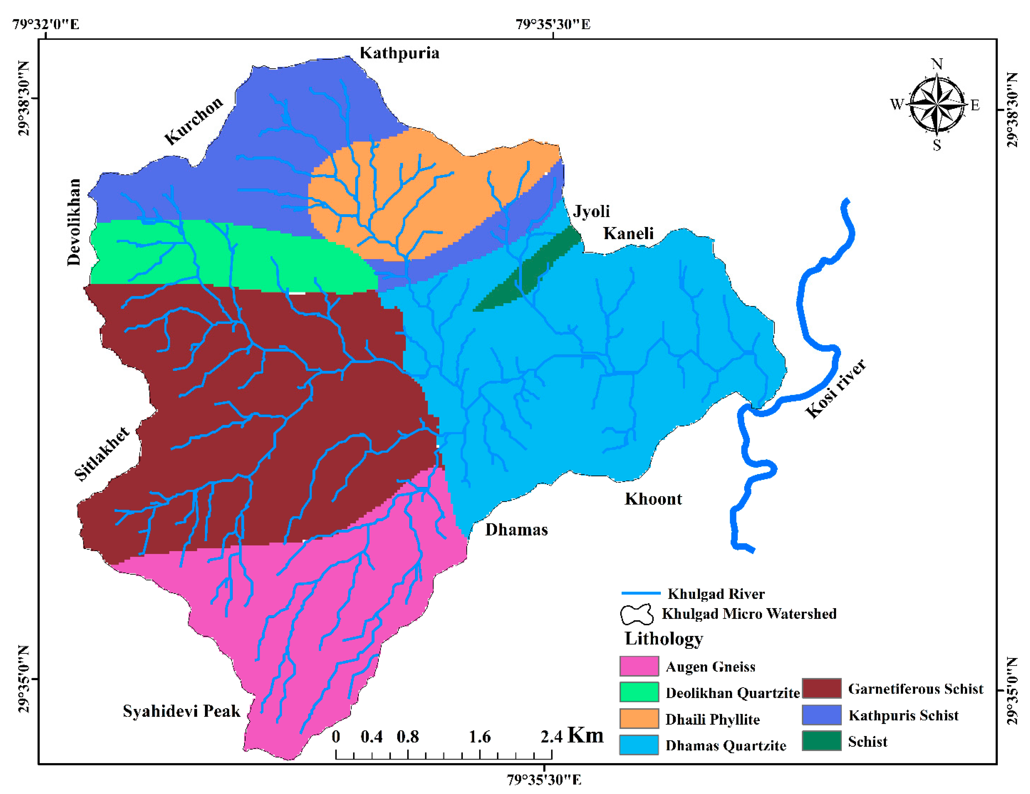
Figure 7.
Land use and land cover map of Khulgad micro watershed.
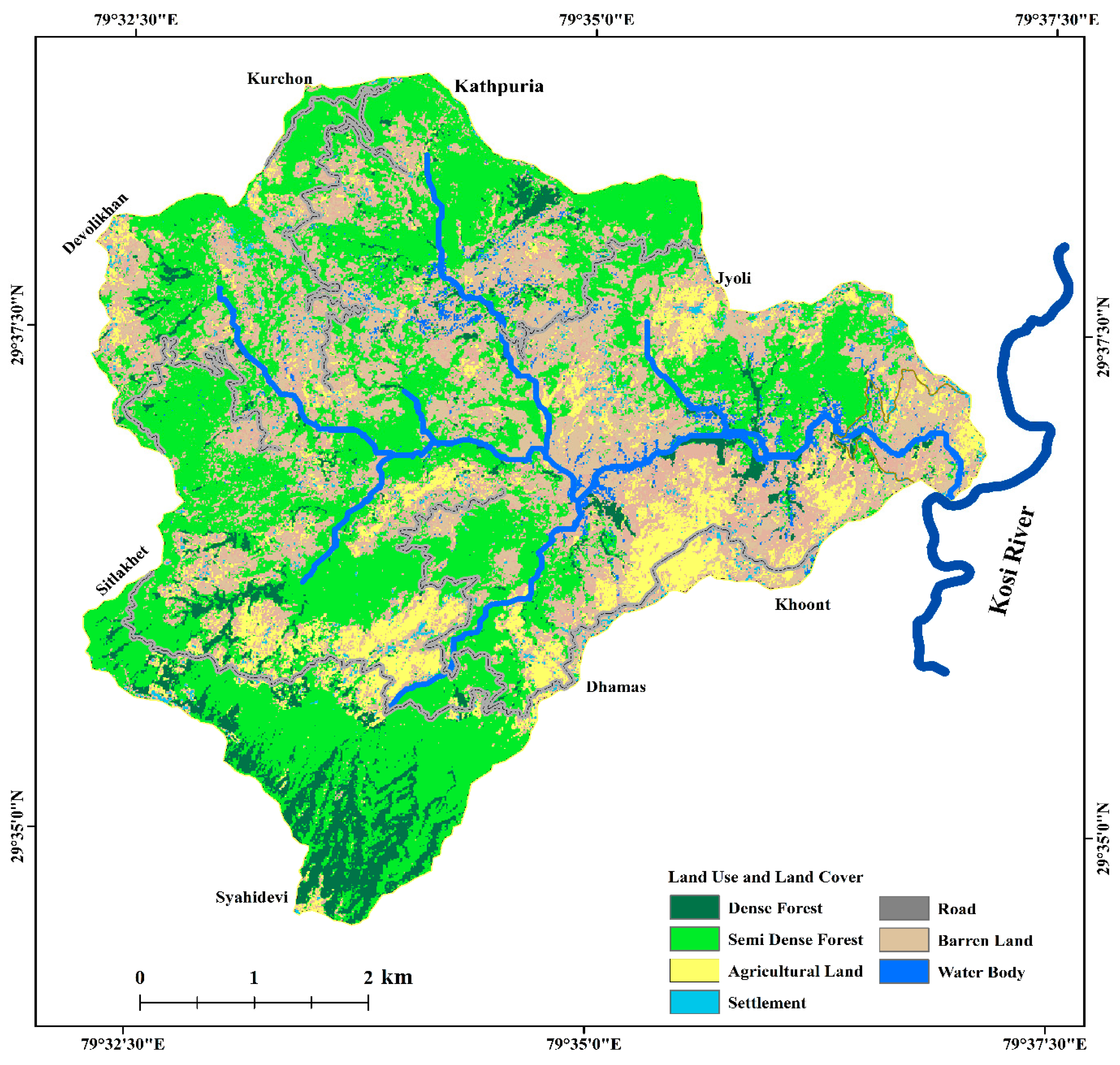
Figure 8.
Slope map of Khulgad micro watershed.
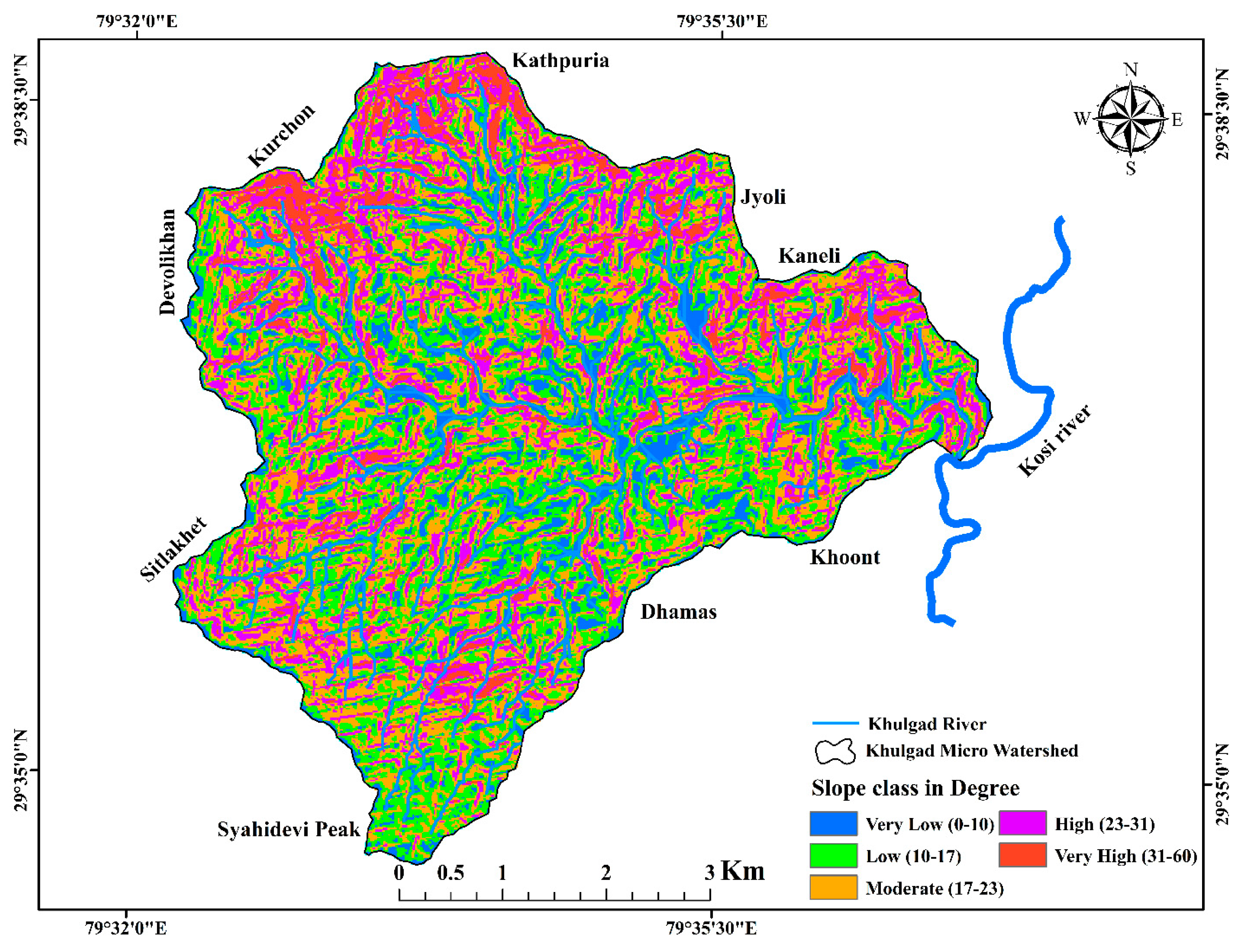
Figure 9.
Rainfall map of the micro watershed of Khulgad.
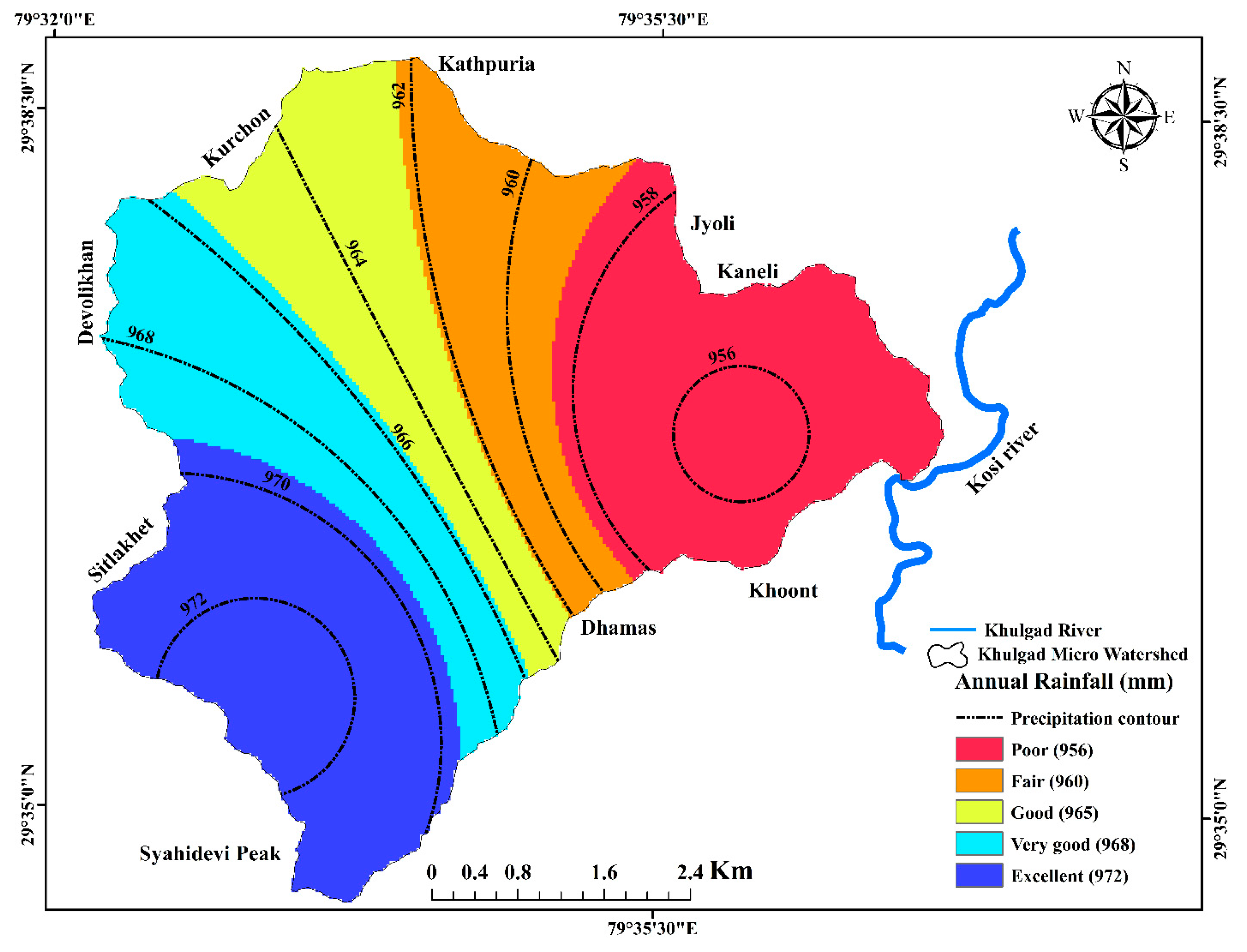
Table 1.
Weights, both assigned and normalized, are attributed to various features within seven thematic layers.
Table 1.
Weights, both assigned and normalized, are attributed to various features within seven thematic layers.
| Themes | Feature/ Classes |
Category of Groundwater Potential Storage | Rank assigned | Weight % |
|---|---|---|---|---|
| Land use/land cover (LULC) | Dense forest Semi dense forest Agricultural land Buildup area Road Barren land Waterbody |
Very High Very High High Low Very low Moderate High |
5 5 4 2 1 3 4 |
6.6 |
| Lineament density (km2) | 0-1.3 1.3-2.5 2.5-3.7 3.7-5.0 5.0-6.5 |
Very low Low Moderate High Very high |
1 2 3 4 5 |
5.0 |
| Drainage density (km2) | 0-2.0 2.0-4.0 4.0-6.0 6.0-8.0 8.0-10.0 |
Very low Low Moderate High Very high |
1 2 3 4 5 |
8.9 |
| Slope (degrees) | 0-10 10-20 20-30 30-40 40-60 |
Very high High Moderate Low Very low |
5 4 3 2 1 |
13.1 |
| Lithology | Gneiss Schist Phyllite Garnetiferous schist Quartzite |
Low Low Moderate Low Very low |
1 1 3 2 1 |
24.5 |
| Soil | Leptosole Luvisole Chernozems |
Very High Moderate Moderate |
5 3 3 |
3.7 |
| Rainfall (mm) | 956-959 960-962 963-966 967-969 970-973 |
Very low Low Moderate High Very high |
1 2 3 4 5 |
38.1 |
Disclaimer/Publisher’s Note: The statements, opinions and data contained in all publications are solely those of the individual author(s) and contributor(s) and not of MDPI and/or the editor(s). MDPI and/or the editor(s) disclaim responsibility for any injury to people or property resulting from any ideas, methods, instructions or products referred to in the content. |
© 2024 by the authors. Licensee MDPI, Basel, Switzerland. This article is an open access article distributed under the terms and conditions of the Creative Commons Attribution (CC BY) license (https://creativecommons.org/licenses/by/4.0/).
Copyright: This open access article is published under a Creative Commons CC BY 4.0 license, which permit the free download, distribution, and reuse, provided that the author and preprint are cited in any reuse.


