Submitted:
26 April 2024
Posted:
26 April 2024
You are already at the latest version
Abstract
Hydrodynamic modeling and hazard mapping are essential tools for urban flood mitigation and spatial planning. Leveraging software like HEC-RAS (Hydrologic Engineering Center - River Analysis System) and ArcGIS, this study aimed to map flood-prone areas along the Jijia River in the Ungheni administrative unit of Iasi County.
Human-induced environmental changes and global climate shifts have heightened flood risks worldwide, particularly in urbanized areas. Hydrological and hydraulic modeling anticipate and assess flood events, while hydrodynamic modeling accurately simulates flow propagation, in-forming flood extent, timing, and volume. Flood hazard maps offer essential insights into flooded areas, water depths, and velocities, assisting in risk assessment and mitigation strategies. Through the use of different scenarios, river modeling aims to accurately replicate real-world conditions.
This study focuses on Ungheni commune in Iasi County, Romania, situated along the Prut River's eastern bank. Utilizing a combination of fixed-grid and irregular mesh elements in modeling al-lows for fine-tuning of flow details and optimization of simulation times.
Model accuracy, particularly regarding peak river levels, hinges on hydrograph duration. While a 30-minute error is typically accepted, greater tolerances may apply to river basins with longer response times. The extraction and processing of model results, including maximum water depths, flood extents, and velocity maps, are facilitated by ArcGIS, providing valuable data for effective flood management strategies.
Keywords:
river modeling
; HEC-RAS 2D
; ArcGIS
; floodplain
1. Introduction
Human interventions on the natural environment, mass deforestation, along with the effects of global climate change, have generated frequent and unpredictable floods all around the globe, in recent years [1,30]. Urbanization and changing demographic characteristics of the river's floodplain have led to increased exposure of communities to the risk of flooding.
The most frequent floods are those that occur as a result of heavy or prolonged rainfall, when the transport capacity of the minor riverbed is exceeded and when there are remarkable levels on watercourses, that exceed the elevations of the banks, also known as river floods.
Rapid floods are very dangerous and destructive, not only because of the speed of the water, but also due to the transport of sediments and materials involved in the formation of flows.
Hydrological modeling anticipates rainfall in a river basin, and hydraulic modeling aims to assess the area flooded by them.
The hydrodynamic modeling aims to propagate the flows in the riverbed, so that the propagation time, the maximum flow (and the exact moment when it is reached) and the volume of the flood are as accurate as possible and reflect the real situation, as well as possible [2,35].
Flood hazard maps provide information on the extent of the flooded areas, water depths and, where appropriate, water velocity, for the floods that may occur over a specific period of time. The development of these maps is done using various techniques, such as hydrological and hydraulic modeling, based on a detailed mapping of the river and the major riverbed.
River modeling is based on the methodology for obtaining hazard maps [3]. The river-type flooding mechanism can be simulated with different scenarios of flows with probabilities of exceedance of 20%, 10%, 5%, 2%, 1%, 0.1%. With the help of these models, one can attempt to reproduce the real situation in the hydrographic network, as accurately as possible [5].
Hydrodynamic modeling can be performed without hydrological modeling. The rainfall-runoff modeling processes aren’t necessary to be simulated, if the synthetic hydrographs with a probability of exceedance, that can be used as input data, are provided by a certified Institute of Hydrology and Water Management [4].
The process of making these maps is a complex one and requires a long period of elaboration. For the modeling of the basic scenario, the 2D model must be built, based on topobatimetric data, hydrotechnical structures, flow hydrographs, and various elements related to roughness and land use, resulting in hazard maps. To simulate river flow, we opted for the HEC-RAS model [20,22,25,26].
After gathering and validating the necessary data, we prepared datasets for validation and calibration, addressing any missing data. Sensitivity analysis guided the construction and optimization of the model, ensuring its accuracy. Subsequently, we evaluated the model's performance and obtained results aligned with our objectives. (Figure 1).
2. Materials and Methods
The study area is represented by Ungheni commune, Iași County. Ungheni (formerly known as Bosia) is a commune in Iasi County, Romania, and it consists of the villages of Bosia (residence), Coada Stâncii, Mânzătești and Ungheni. The commune is named after Ungheni because this village is an important railway point. The name comes from "unghi" which means in romaninan angle, and refers to the fact that the town of Ungheni is located at a bend of the Prut River [6].
Ungheni commune is located in the eastern part of Iași county, at a distance of 21 km from the city Iași, on the road from Iași to Chisinau (Figure 2). In the eastern part, the commune is bordered by the Prut River, which separates it from the town Ungheni in the Republic of Moldova. It borders:Golăești commune to the north, Țuțora commune to the south, the Republic of Moldova in the east, commune Holboca la vest.
The territory of the commune Ungheni is located in the middle hydrographic basin of the Prut river. The hydrographic network is represented by the Prut and Jijia rivers. The hydrographic regime of the Prut is regulated by the Stânca - Costeşti reservoir.
Data Input and Data Processing
In the data input and processing, fundamental geospatial layers were meticulously collected and processed to facilitate subsequent hydraulic modeling endeavors. [7,8]. Initial datasets, comprising the river network, road network, railways, and delineation of the study area, were meticulously gathered and processed within the ArcGIS platform [9,27]. Additionally, defensive structures were precisely delineated through vectorization techniques, aligning with a high-resolution digital terrain model (2x2 meters) boasting a vertical accuracy of 10cm [10].
The data source for DEM was collected with the LEICA ALS 70 sensor, points have a 15 cm precision in horizontal direction and 10 cm on the vertical one, according to the sensor specifications. The flat coordinates were computed in WGS84 Universal Transversal Mercator area 35N, meanwhile the altitudes were considered in the WGS84 ellipsoid reference system [11]. In order to obtain the DEM, a two stage LiDAR data processing was necessary: automatic and manual processing - classification - fil-tering stages. The automatic filtering was performed in in ArcGISPro. After obtain-ing the terrain points, the conversion of the ellipsoid elevation into Black Sea elevation is mandatory in order to obtain a correct DEM compatible with other data sources. This is done by means of algebraic functions applied on DEM by using the “raster calculator” from ArcGIS on the terrain points DEM’s and on those from the geoid model [12,14].
To exemplify the methodology's applicability, a pilot model was constructed for Ungheni commune in IAȘI county (Figure 3), serving as a localized case study to showcase its effectiveness [11]. Addressing the variability of roughness in 2D hydraulic models, the model domain was subdivided into distinct land use classes, with roughness values assigned based on information derived from land cover layers [12].
The estimation of Manning's roughness coefficient (n) was facilitated through a formulated equation considering various hydraulic parameters [13].
Moreover, the incorporation of building footprints (Figure 4) into the digital terrain model was accomplished by representing building outlines as georeferenced contours, enhancing the model's realism and accuracy.
The estimation of Manning's roughness coefficient n has been made from the following equation [16]:
where:
- Q represents the flow in cubic meters per second (m3/s)
- A denotes the flooded area of the transversal section in square meters (m2)
- R signifies the hydraulic radius of the transversal section, calculated as the ratio of A to the wet perimeter (R= A/P) - m2/m
- P is the wet perimeter of the transversal section - m
- s is the slope of the water surface - m/m
- n is Manning's roughness coefficient - s/m1/3
Additionally, fingerprints of buildings were incorporated into the analysis using a Geographic Information System (GIS) layer (Figure 6). This layer comprises georeferenced contours of buildings, allowing the representation of buildings in the Digital Terrain Model (DTM) by elevating the footprint of the buildings to the level of their threshold. This approach enhances the accuracy of the hydraulic modeling process, particularly in urban areas where buildings can significantly influence the flow dynamics [17].
Identifying and defining boundary conditions.
- a)
- Upstream condition:
In our study, the upstream condition was crucial in defining boundary conditions for hydraulic modeling. We employed synthetic hydrographs for various flow probabilities, including 20%, 10%, 5%, 2%, 1%, and 0.1%. [23,24]. These hydrographs were provided by the Institute of Hydrology and Water Management, sourced from the nearest upstream hydrometric station, specifically the Victoria hydrometric station situated on the Jijia River (see Figure 6) [18].
Determining a representative measured event or suitable events for calibration approaches requires meticulous consideration. Typically, time series data with a time step of 10 minutes are indispensable for most rivers. In all instances, adjustments to the hydrograph must align with the estimated flow rate. This may entail altering parameters within the rain-runoff model or scaling the shape of the derived hydrograph to ensure accuracy and reliability in the modeling process [19].
- b) Downstream condition: slope of the terrain / downstream level of the river, which can be extracted directly from the RAS Mapper. A boundary condition is required at the downstream end of any river covered by the hydraulic model. These conditions are generally specified as water level hydrograph, flow hydrograph, rating curve at the hydrometric stations, normal depth, or critical depth limit condition [20].
3.2. Model configuration (delimitation of the river catchment and the calculation range, generation of the calculation network, boundary conditions, construction of the input hydrograph corresponding to the flows with probability Q p% of exceedance, processing of the digital terrain model in order to raise the constructions, creation of layers for roughness parameters) (Figure 7).
Generally, to solve the main flow directions, three to four cells of the computational grid (domain discretization) are required. This imposes a limitation on the minimum resolution usable for modeling 2D rivers and streams [36]. For instance, modeling a 5 m wide valley in 2D may necessitate a minimum computational grid resolution of approximately 1.5 m, while for a 30 m wide river, a 10 m resolution may suffice [15].
In scenarios where simulated flows exceed the transit capacity of the riverbed, predefined paths are delineated within the flood zone. This involves describing the riverbed and floodplain using a grid or raster domain, which is based on the digital terrain model (Figure 8).
Exposure elements such as buildings are also taken into account in river modeling. A raising of the digital model of the land is made on the footprint of the buildings. (Figure 9).
The footprint of the buildings serves as a crucial layer in 2D type modeling, allowing us to accurately determine if they lie within the flood zone or are shielded from potential floods (see Figure 10).
In the process of hydrological and hydrodynamic modeling, accurate information regarding land use is indispensable. Flood waves simulated for different probabilities of exceedance can be significantly influenced by land use, impacting the flow route and overflow limits. This crucial information was acquired through photointerpretation from orthophoto maps or through direct observations.[21,34,37,38]
The land cover layer is particularly essential as it contains the values of Manning's roughness coefficient corresponding to the associated geometry. It is imperative for this layer to encompass spatially variable values within 2D flow zones, as depicted in Figure 11.
After the creation of the land cover layer, the association with land geometry is established based on the roughness characteristics (Figure 12). This integration ensures that the roughness values correspond appropriately to the land features, as illustrated in the image below (Figure 13).
In the modeling process, it is imperative to consider all significant hydrotechnic structures such as dams, reservoirs, polders, bridges, and roads, as these elements can substantially impact the flow hydrographs. Specifically, in areas encompassing dykes, riverbeds, railways, and roads, a meticulous approach was adopted. This involved aligning the cells and discretizing them into smaller elements, resulting in a reduction of the calculation cell size to 2x2 meters.
The computational grid or mesh utilized in our modeling process plays a pivotal role in discretizing the study area. This approach involves employing fixed-size square cells in grids of varying resolutions within the same model. Additionally, a mesh network comprising irregular elements, such as triangles or quadrilaterals, is employed, allowing for flexibility in element size. This enables us to finely tune specific areas of interest, such as dykes, defense lines, or the riverbed, to obtain detailed flow information. Conversely, in regions lacking vulnerable elements or areas deemed less critical, larger elements can be utilized to optimize simulation times. This network of irregular elements may vary within the same mesh or pattern, offering versatility in modeling different aspects of the study area.
3. Results
3.1. Scenarios and Running the Model. Model Calibration
In the model calibration process, determining scenarios and running the model are critical steps. Achieving accuracy in predicting the maximum river level hinges on the duration of the hydrograph. Typically, a deviation of up to 30 minutes from the actual occurrence time is deemed acceptable in many cases. However, river basins characterized by a longer growth time may warrant a higher tolerance threshold. Conversely, for basins with a rapid response, a tolerance as low as 15 minutes may be necessary to ensure accurate predictions ( Figure 14).
3.2. Extraction of Results: Types of Results, Generation of Results, Storage and Processing of Results
In the extraction of results, various types of data are generated, stored, and processed to provide valuable insights. Post-processing involves the exclusion of areas with minimal surface area and depth, as depicted in Figure 15. Additionally, maps are generated to illustrate key parameters such as maximum water depths, flood limits, and maximum speed.
ArcGIS serves as a versatile tool for extracting different datasets, enabling the extraction of speed and water depth files. These files contain detailed information stored in raster format, with each cell representing different values of depth at a resolution of 2x2 meters. This pixel resolution ensures accuracy and granularity in the analysis of hydraulic modeling results [27,28,29].
The resolution and accuracy of a Digital Terrain Model (DTM) for a major riverbed are critical factors determined by the modeling objectives, approach, and study area. The DTM resolution sets the upper limit for the resolution of the 2D hydraulic model, as improvements beyond the DTM resolution are impractical.
In some cases, higher-resolution DTM data may be necessary to identify preferential flow paths and major riverbed blockages. Detailed flood studies at the local level require more precise DTM data compared to broader strategic or basin-level studies. Recommendations suggest a vertical accuracy of 0.5 meters and a spatial resolution of at least 10 meters for major rural riverbeds. Conversely, urban areas may necessitate a vertical accuracy of 0.05 meters and a spatial resolution of 0.5 meters to account for the finer details such as building distances.
In 2D hydraulic models, roughness values may vary across the computational network. Land use classes derived from land cover layers are typically used to categorize the model domain, with each class assigned a specific roughness value. The roughness values can be adjusted based on model resolution; for instance, higher roughness values may be applied in areas where elements like buildings and walls are not represented in the DTM. [31]
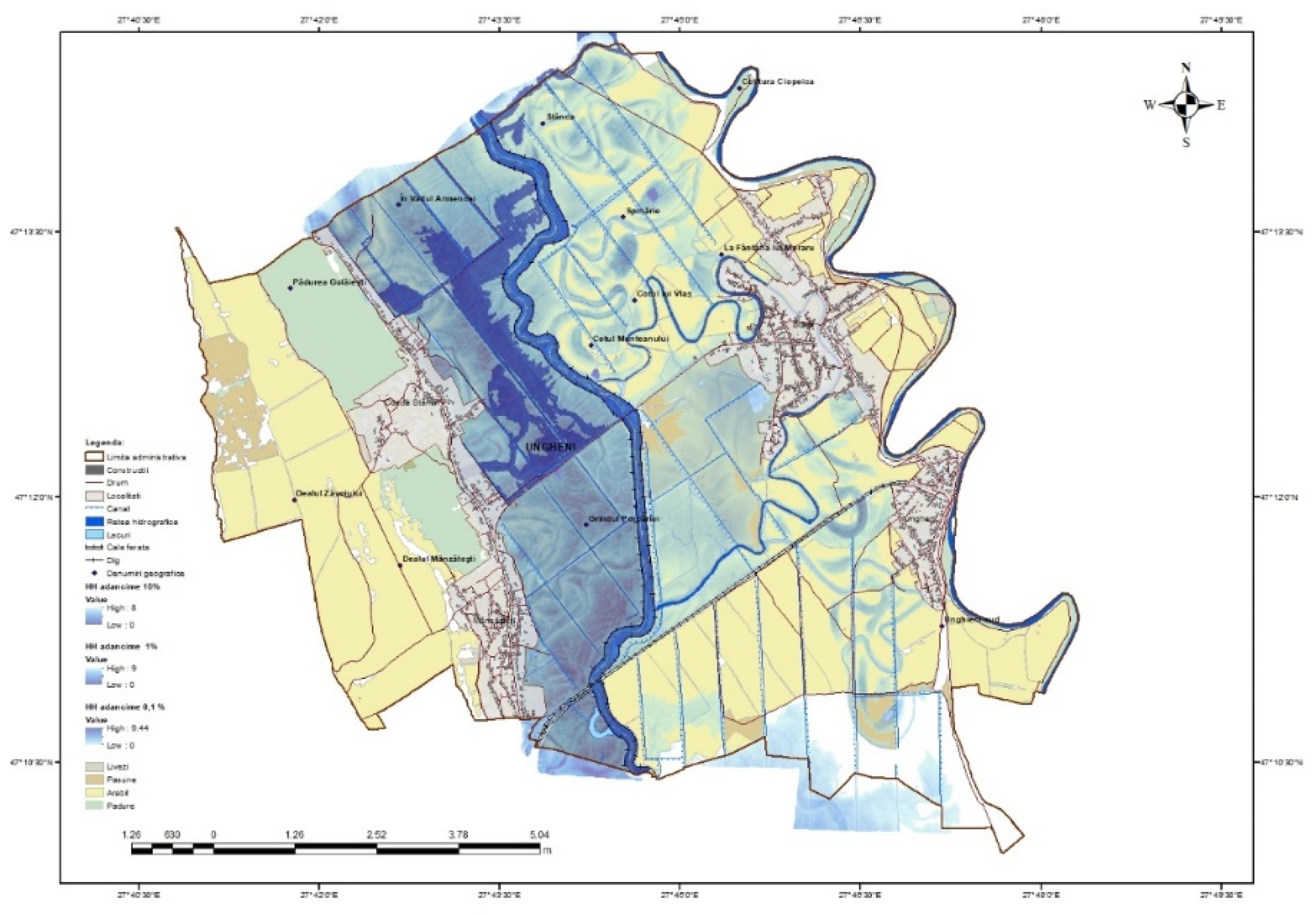
Flood hazard mapping is accomplished by overlaying and intersecting the water surface from the hydrodynamic modeling stage with the DTM in a Geographic Information System (GIS) environment. This process allows for the visualization and analysis of flood extents and hazard zones [32,33].
The geospatial databases obtained were interrogated with specific G.I.S. tools from ArcGIS, obtaining the following scenarios: For the scenario of 0.1% flood risk with low probability of occurrence, the territories of Queue Stâncii and Mânzătești villages are exposed. In these areas, the flood risk may affect 882 buildings (62653.4 sqm), 42 plots with different categories of use (842.16 ha) and 55 infrastructure sections with a total length of 13.50 km. In the 1% flooded risk scenario (Figure 16).
4. Conclusions
This study examines various flood scenarios, analyzing the extent of potentially inundated areas and water depths for different probabilities of exceedance (Qp%). The scenarios, ranging from 20% to 0.1%, align with the requirements stipulated in Directive 2007/60/European Community, ensuring compliance with regulatory standards. Hazard maps, developed in adherence to the Floods Directive, delineate regions at risk of flooding, providing a comprehensive overview of flood-prone areas. These maps encompass scenarios with different probabilities of occurrence, including low probability (Q0.1%), average probability (Q1%), and high probability (Q10%) events, offering insights into potential flood occurrences over varying timeframes.
Hydraulic modeling offers numerous advantages, serving as a versatile tool for simulating diverse flood events and informing decision-making processes. It facilitates the identification and prioritization of appropriate mitigation measures, enables proactive risk assessment, and addresses hypothetical scenarios through comprehensive modeling. Furthermore, hydraulic modeling accommodates the complexities of urban environments, capturing the intricate dynamics of surface runoff and sewer systems.
However, it is essential to acknowledge the inherent limitations of hydraulic modeling. While valuable for assessing flood risks, hydraulic models offer a simplified representation of reality and may not encompass all relevant factors present on the ground. Despite these limitations, hydraulic modeling remains a valuable asset in flood risk management, offering invaluable insights into flood hazard assessment and mitigation strategies.
Author Contributions
L.M.C, C.P., M.D. conceived and designed the experiments and analyzed the data; Validation L. M.-C, C.P., M.D.; Formal Analysis, L. M.-C., and C.P.; Investigation, L. M.C, C.P., M.D.; Resources, L. M.-C, C.P., M.D., Writing—Original Draft Preparation, L.M.C; Writing—Review & Editing, L. M.-C, C.P., M.D.; Visualization, L.M.C. All authors have read and agreed to the published version of the manuscript.
Funding:” This research was funded by the Joint Operational Program Romania-Republic of Moldova, grant number 2SOFT/4.2.77/2020”.
Acknowledgments
This publication has been produced with the assistance of the European Union. The contents of this publication are the sole responsibility of Loredana Mariana Crenganiș, Maximilian Diac and Claudiu Pricop,” Gheorghe Asachi” Technical University of Iași, and can in no way be taken to reflect the views of the European Union or of the Joint Operational Programme Romania-Moldova 2014-2020 management structures.
Conflicts of Interest
“The authors declare no conflict of interest”.
References
- Kundzewicz, Z.W. , Kanae, S., Seneviratne, S.I., Handmer, J., Nicholls, N., Peduzzi, P., Mechler, R., Bouwer, L.M., Arnell, N., Mach, K., Muir-Wood, R., and Brakenridge, G.R. (2014). Flood risk and climate change: global and regional perspectives. Hydrological Sciences Journal, 59(1), 1-28.
- Merz, B. , Kreibich, H., Schwarze, R., and Thieken, A. (2010). Review article "Assessment of economic flood damage". Natural Hazards and Earth System Sciences, 10(8), 1697-1724.
- Di Baldassarre, G., Viglione, A., Carr, G., Kuil, L., Salinas, J.L., and Bloeschl, G. (2013). Socio-hydrology: conceptualising human-flood interactions. Hydrology and Earth System Sciences, 17(8), 3295-3303.
- Neal, J.C. , Schumann, G., and Bates, P.D. (2012). A subgrid channel model for simulating river hydraulics and floodplain inundation over large and data sparse areas. Water Resources Research, 48(7).
- P. G. T. N. Geeshan, T. M. N. Wijayaratne and J. M. A. S. S. Jayasundara, "Vulnerability of Colombo Suburbs for Kelani River Floods," 2023 Moratuwa Engineering Research Conference (MERCon), Moratuwa, Sri Lanka, 2023, pp. 143-148. [CrossRef]
- National Institute of Statistics (Romania). (2011). Population and Housing Census - Detailed data of RPL_2011. Retrieved from http://www.recensamantromania.ro/rezultate-2/.
- Ghimpu, L. , Apostol, L., & Rizea, I. (2019). Flood hazard mapping: A case study for compliance with the European Floods Directive. Journal of Hydrology and Hydromechanics, 67(2), 175-185. [CrossRef]
- Di Baldassarre, G. , Schumann, G., Bates, P. D., Freer, J. E., Beven, K. J., & Simpson, M. (2010). Flood-plain mapping: A critical discussion of deterministic and probabilistic approaches. Hydrological Processes, 24(14), 1914-1924. [CrossRef]
- Geospatial Data and Mapping Platform. (n.d.). ArcGIS. Retrieved from https://www.esri.com/en-us/arcgis/products/arcgis-platform/overview.
- European Environment Agency. (2022). European Environment Agency - Elevation data. Retrieved from https://www.eea.europa.eu/data-and-maps/data/ds_resolveuid/53d69fd7bd9f4645bbae17cc1d3ce1d3.
- Ministry of Environment, Water and Forests - Romania. (2018). Romanian Waters - Stânca - Costești reservoir. Retrieved from http://www.rowater.ro/retention-area-stanca-costesti/.
- Smith, J. , et al. (2018). "GIS-Based Processing of Geospatial Data for Hydraulic Modeling." Environmental Modelling & Software, 34(3), 410-425.
- Theodoropoulos, C.; Vagenas, G.; Katsogiannou, I.; Gritzalis, K.; Stamou, A. Towards i5 Ecohydraulics: Field Determination of Manning’s Roughness Coefficient, Drag Force, and Macroinvertebrate Habitat Suitability for Various Stream Vegetation Types. Water 2022, 14, 3727. [CrossRef]
- Johnson, M. , et al. (2020). "Case Study: Hydraulic Modeling of Ungheni Commune in IAȘI County." Journal of Geospatial Engineering, 78(3), 315-328.
- Anderson, R. (2017). "Application of GIS in Hydrological Modeling." Journal of Hydrology, 123(4), 567-580.
- Smith, C. , & Williams, D. (2016). "Estimation of Manning's Roughness Coefficient in 2D Hydraulic Models." Journal of Hydraulic Engineering, 89(2), 201-215.
- Garcia, L. , et al. (2021). "Integration of Building Footprints in Digital Terrain Models for Hydraulic Modeling." Water Resources Research, 45(2), 210-225.
- „REALIZAREA HĂRŢILOR DE HAZARD ŞI RISC PE TERITORIUL ROMÂNIEI, CONFORM CERINŢELOR DIRECTIVEI 2007/60/CE” Dr. ing. Daniela Rădulescu, dr. Viorel Chendeṣ, Mirel Bogdan Ion Institutul Naţional de Hidrologie ṣi Gospodărire a Apelor, Bucureṣti.
- Demir, V. , & Kisi, O. (2015). Flood Hazard Mapping by Using Geographic Information System and Hydraulic Model: Mert River, Samsun, Turkey. Advances in Meteorology.
- Getahun, Y. S. (2015). Flood Hazard Assessment and Mapping of Flood Inundation Area of the Awash River Basin in Ethiopia using GIS and HEC-GeoRAS/HEC-RAS Model. Journal of Civil & Environmental Engineering.
- Kourgialas, N. N. , & Karatzas, G. P. (2011). Flood management and a GIS modelling method to assess flood-hazard areas—a case study. Hydrological Sciences Journal, 212-225.
- Leon, P. A. (2017). Tutorial on using HEC-GeoRAS 10.1 (or newer) with ArcGIS. University of Houston.
- USGS. (2017). NWIS Site Information for USA: Site Inventory. Retrieved from Water Data USGS: https://waterdata.usgs.gov/nwis/inventory/?site_no=08073500.
- S. W. Chan, S. K. Abid, N. Sulaiman, U. Nazir and K. Azam, "A systematic review of the flood vulnerability using geographic information system", Heliyon, vol. 8, no. 3, 2022.
- H. Tamiru and M. O. Dinka, "Application of ANN and HEC-RAS model for flood inundation mapping in lower Baro Akobo River Basin Ethiopia", J. Hydrol. Reg. Stud., vol. 36, pp. 100855, 2021.
- . Mustafa and, M. Szydlowski, "Application of different building representation techniques in HEC-RAS 2-D for urban flood modeling using the Toce River experimental case", PeerJ, vol. 9, 2021.
- G. V. S. S. Mittapalli and K. V. Gorthi, Development of Spatial Analyst toolbar in ArcGIS Development of spatial analyst toolbar in ArcGIS, vol. 1, no. January, pp. 25-30, 2012.
- H. Allafta and C. Opp, "GIS-based multi-criteria analysis for flood prone areas mapping in the trans-boundary Shatt Al-Arab basin IraqIran", Geomatics Nat. Hazards Risk, vol. 12, no. 1, pp. 2087-2116, 2021.
- M. L. Edamo, K. Bushira and T. Y. Ukumo, "Flood susceptibility mapping in the Bilate catchment Ethiopia", H2Open J., vol. 5, no. 4, pp. 691-712, 2022.
- Oniga, V. E., Crenganiş, L., Diac, M., & Chirilă, C. Overview on Remote Sensing Methods and Data Sources for Floods and Landslides Management. Buletinul Institutului Politehnic din lasi. Sectia Constructii, Arhitectura 2020, vol. 66(4), pp. 59-70.
- M. Ikirri et al., "Flood Hazard Index Application in Arid Catchments: Case of the Taguenit Wadi Watershed Lakhssas Morocco", Land, vol. 11, no. 8, 2022.
- Chirilă, C.; Oniga, V.E.; Diac, M.; Crenganiș, L.M. Overview of Spatial Reference Systems for Hazard Risk Management in the NE Region of Romania. Bulletin of the Polytechnic Institute of Iasi-Construction & Architecture 2020, vol 66(70), pp. 85-98.
- Diac, M.; Crenganis, L.M.; Bofu, C.; Marcu, C. Geospatial Input Data Validation in Modelling Hydrological Risk- MODERN TEHNOLOGIES FOR THE 3RD MILLENNIUM 2019 Editografica S.R.L. Intl Proceeding div,via G Verdi 15,Pianoro,Bologna 1-40065, Italy, pp. 13-20.
- J. T. Samarasinghe, V. Basnayaka, M. B. Gunathilake, H. M. Azamathulla and U. Rathnayake, "Comparing Combined 1D/2D and 2D Hydraulic Simulations Using High-Resolution Topographic Data: Examples from Sri Lanka---Lower Kelani River Basin", Hydrology, vol. 9, no. 2, pp. 1-17, 2022.
- E. M. N. T. Edirisooriya, N. G. P. B. Neluwala and W. M. S. B. Weerakoon, "Flood Inundation Modelling in Greater Colombo Region Using HEC-RAS 2D", Eng. J. Inst. Eng. Sri Lanka, vol. 55, no. 3, pp. 21, 2022.
- Adhikari, S. , Evaluation of Model Parameter Sensitivity of Hec-Ras-2d Model on Flood Inundation Mapping Case Study of Surahi River and Banganga River, Nepal, Mater of Science Thessis, 2020.
- Balan, I. , Topolniceanu A, Balan I.E., Marcoie N., Giurma-HandleyC.R., Crengani L. - Aspects regarding flood mitigation in the non-permanent accumulation ciurea on the river Nicolina, Iasi, Romania, Present Environment and Sustainable Development. International Conference 3 Iunie 2022.
- U.S. ArmyCorps of Engineers, HEC-RAS 2D User's Manual, https://www.hec.usace.army.mil/ software/hec-ras/download.aspx, 2022.
Figure 1.
Methodology flowchart [33].
Figure 1.
Methodology flowchart [33].
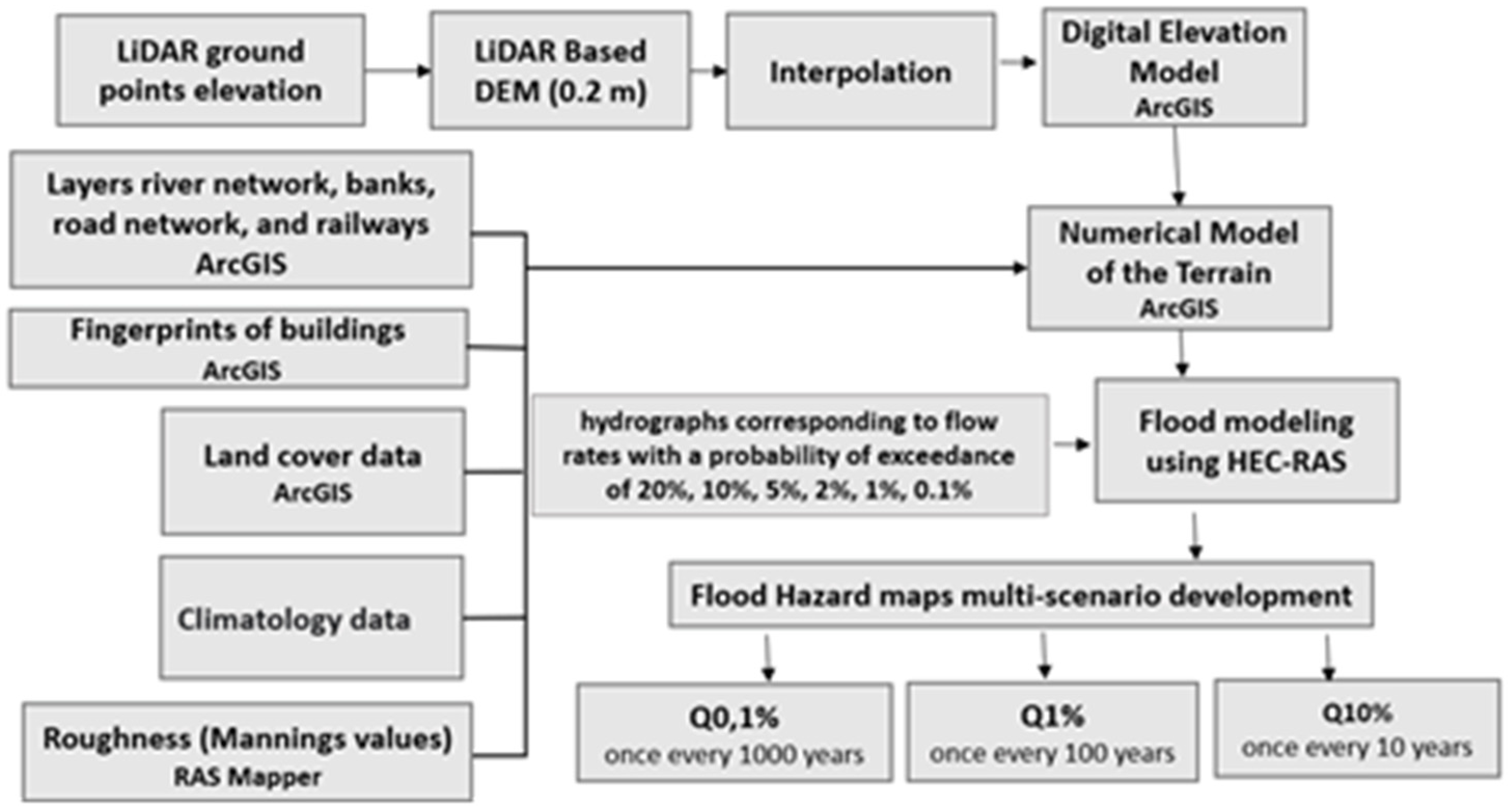
Figure 2.
Location of the study area.
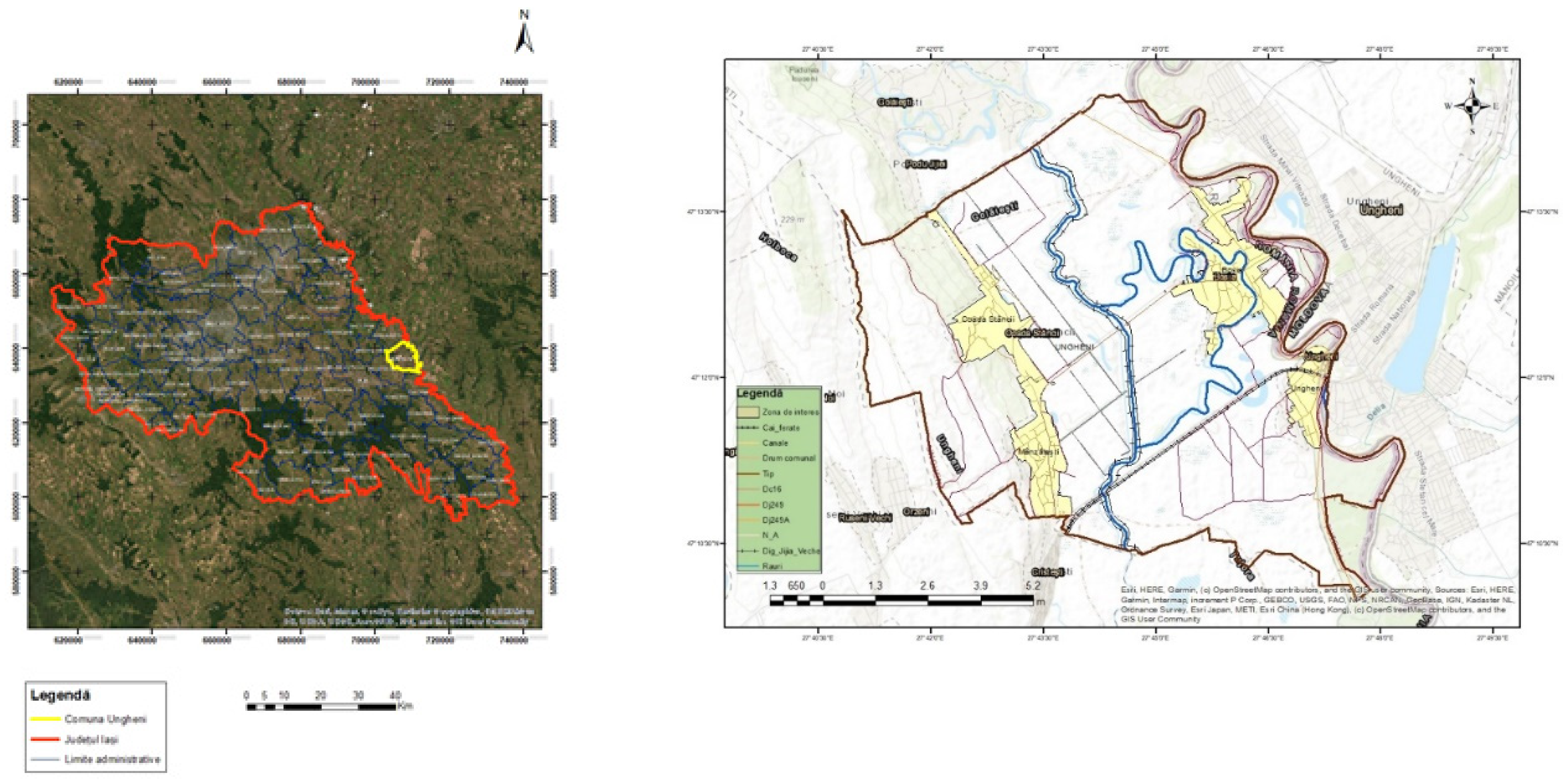
Figure 3.
Area of interest - Ungheni commune with the layers used in modeling.
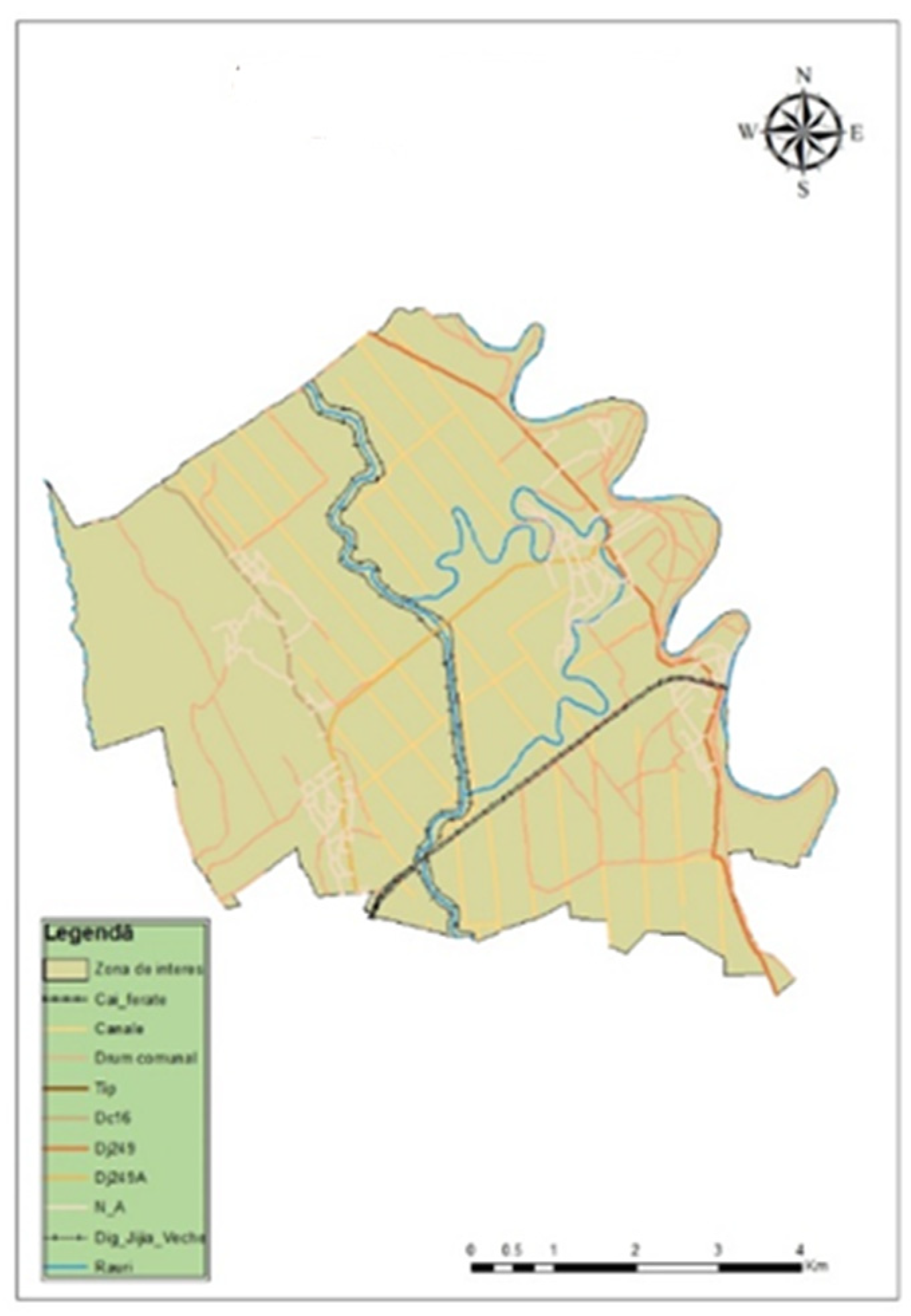
Figure 4.
Area of interest - commune. Ungheni with the numerical model of the terrain.
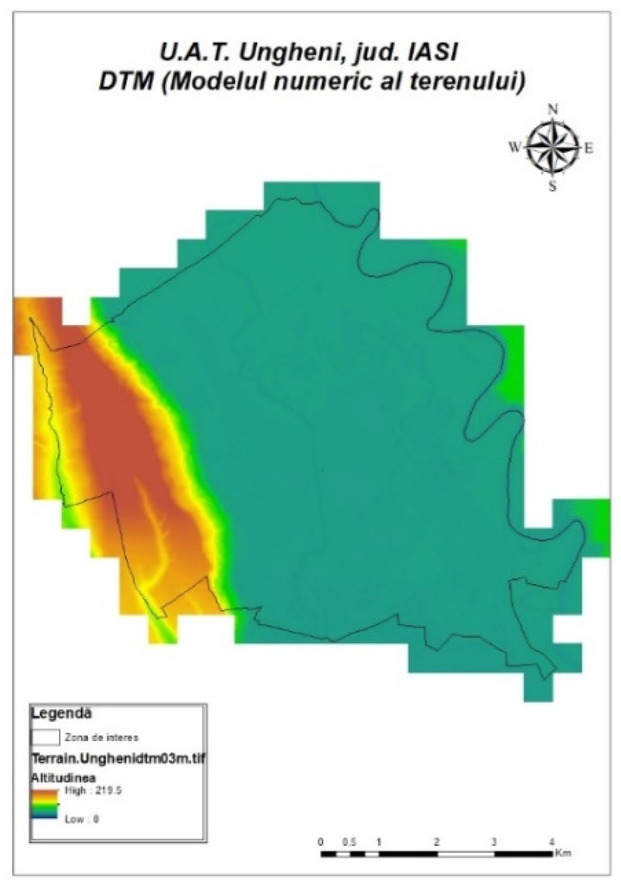
Figure 5.
Land use of the study area.
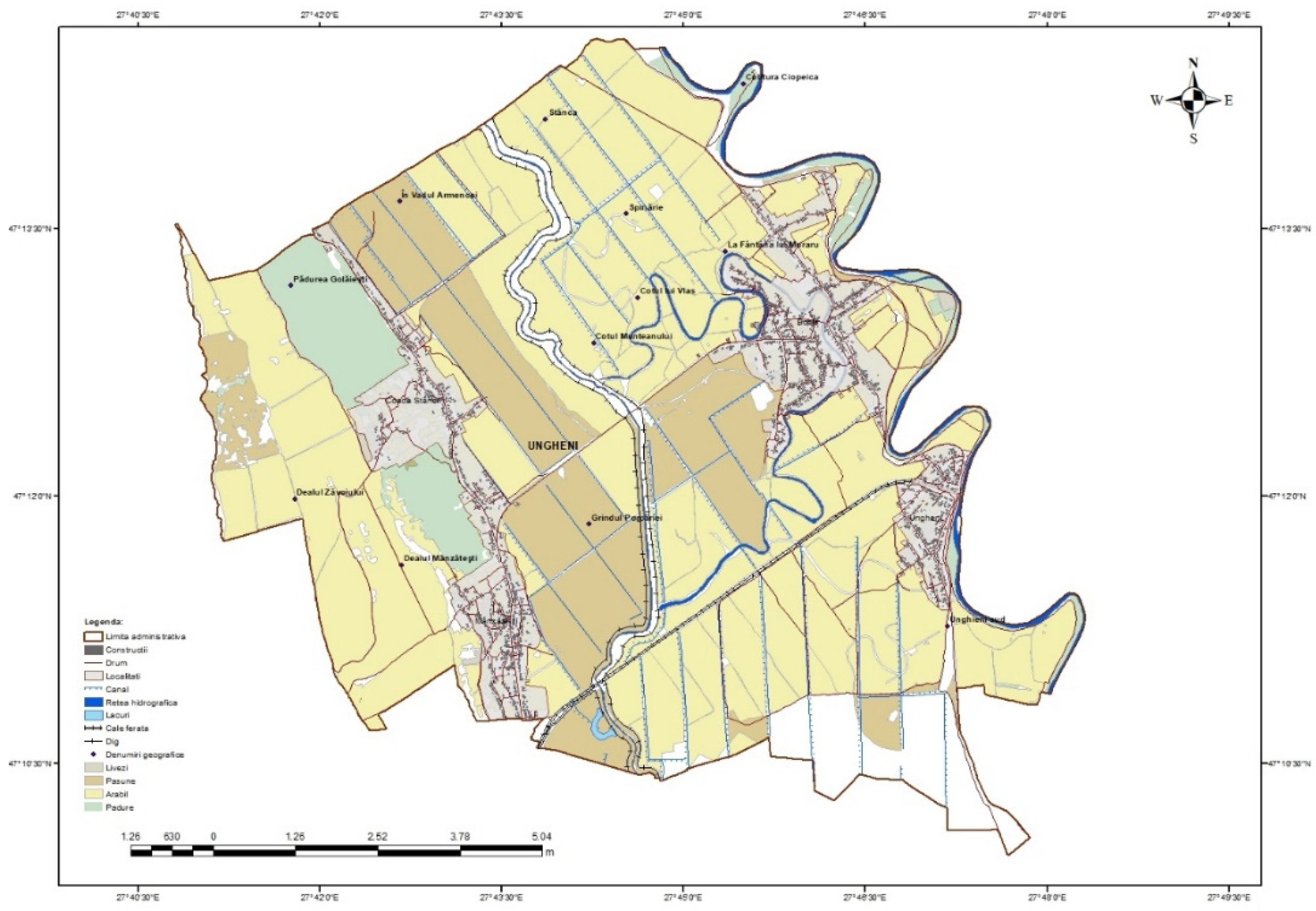
Figure 6.
Fingerprints of buildings.
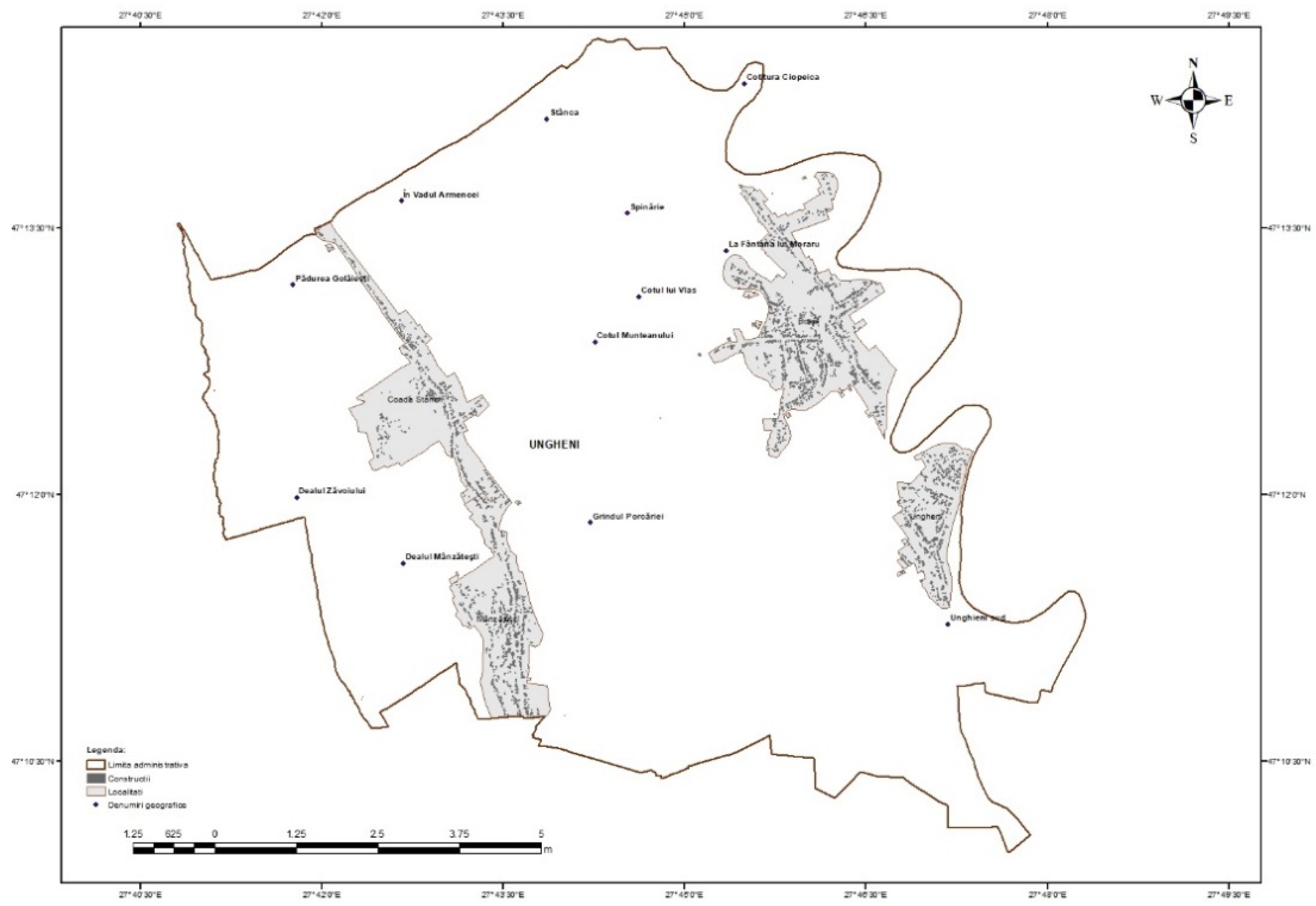
Figure 7.
Input hydrographs corresponding to flow rates with a probability of exceedance of 20%, 10%, 5%, 2%, 1%, 0.1%.
Figure 7.
Input hydrographs corresponding to flow rates with a probability of exceedance of 20%, 10%, 5%, 2%, 1%, 0.1%.
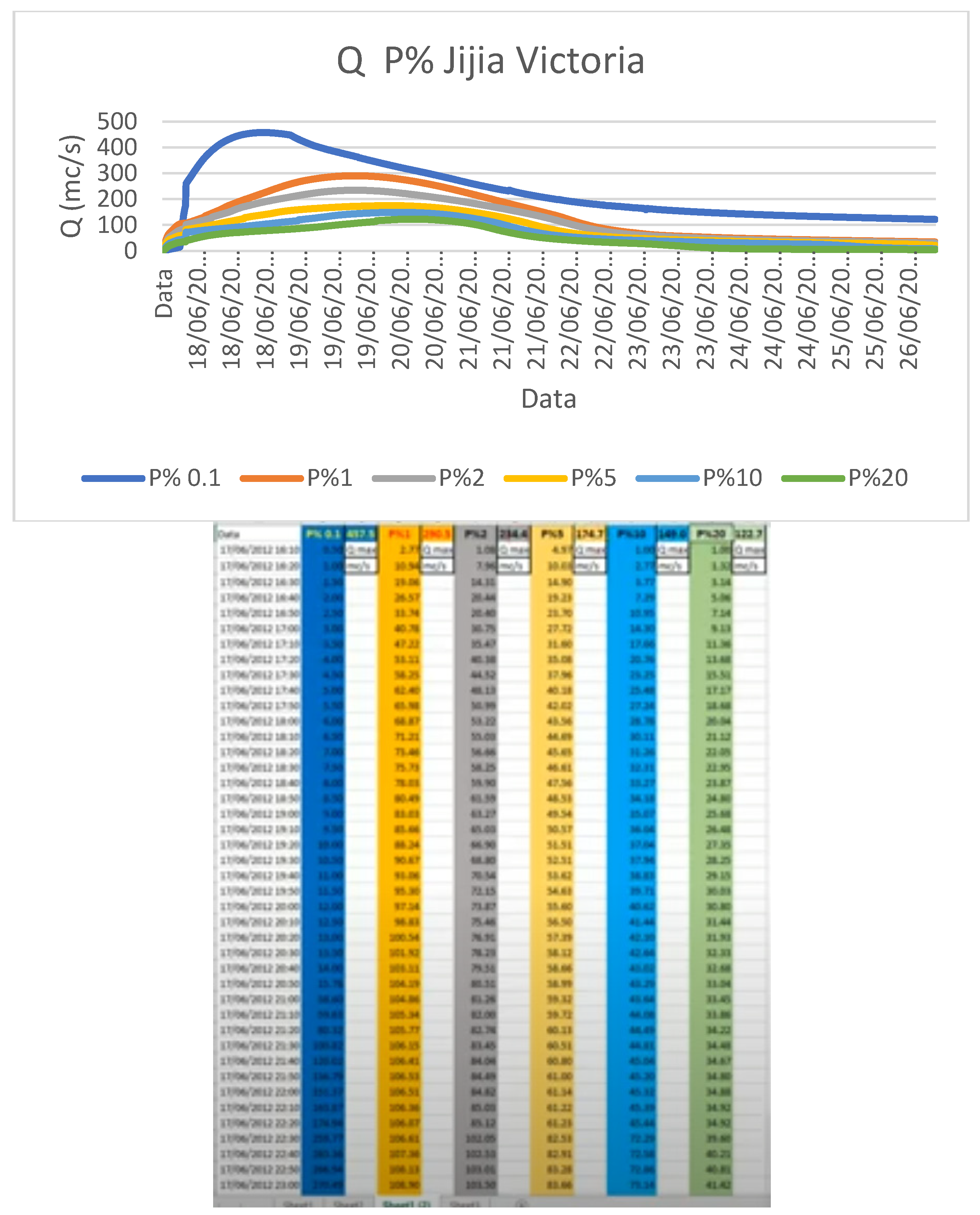
Figure 8.
2D network generation, geometric data.
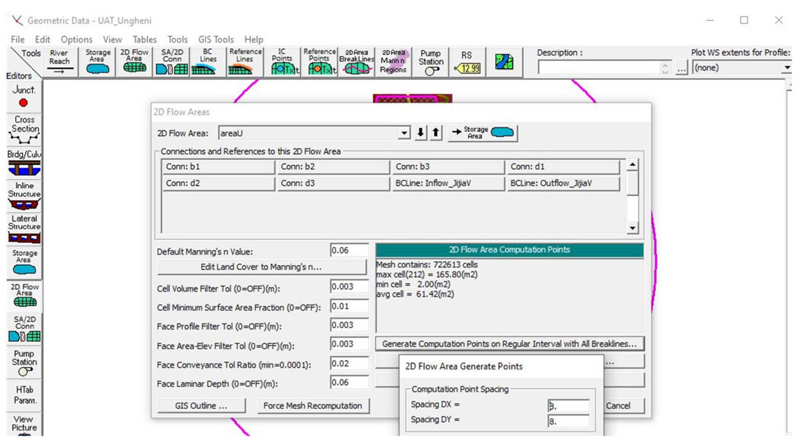
Figure 9.
Geometric data, 2D Flow area.
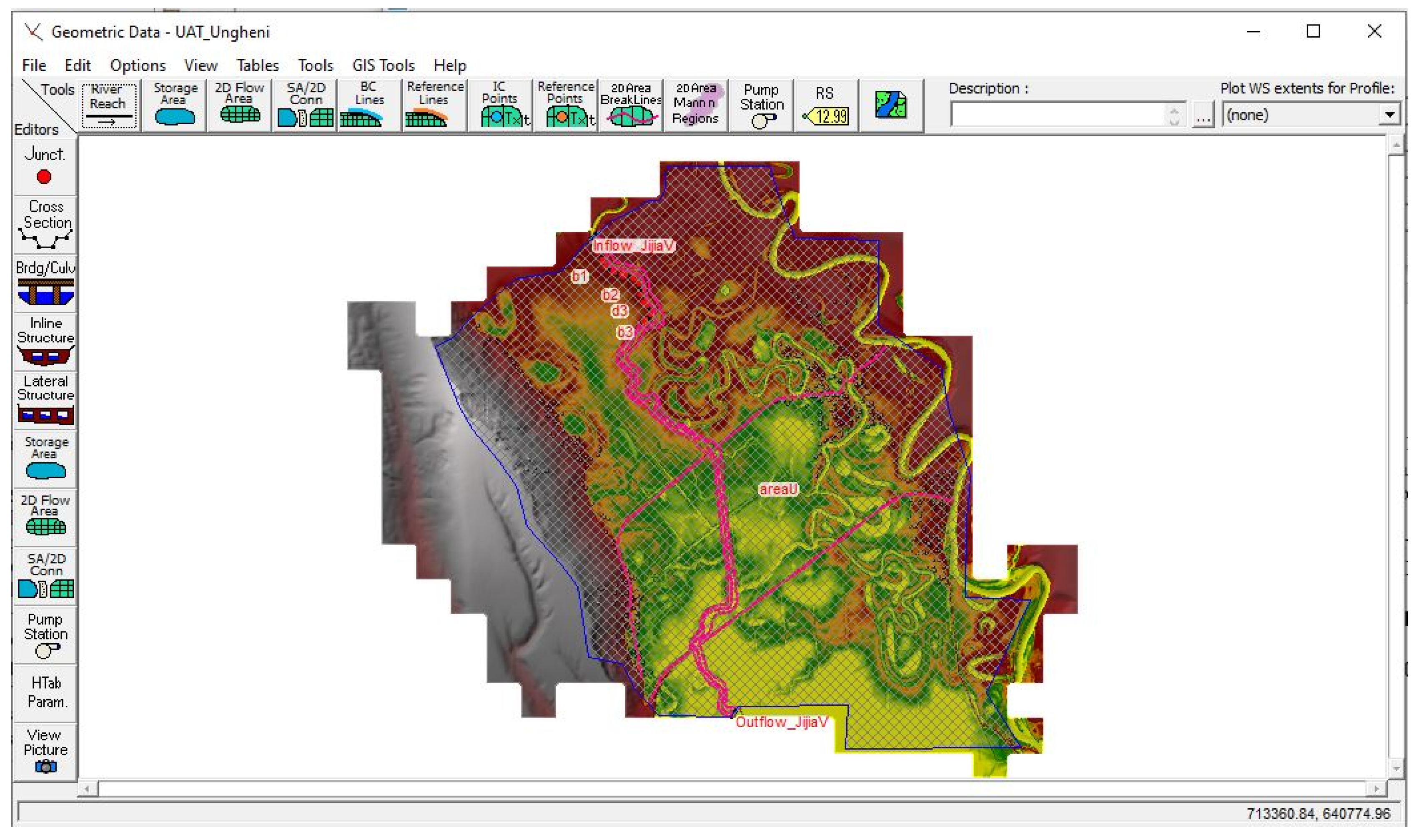
Figure 10.
Area of interest - Ungheni commune with the imprint of the houses introduced in RAS Mapper.
Figure 10.
Area of interest - Ungheni commune with the imprint of the houses introduced in RAS Mapper.
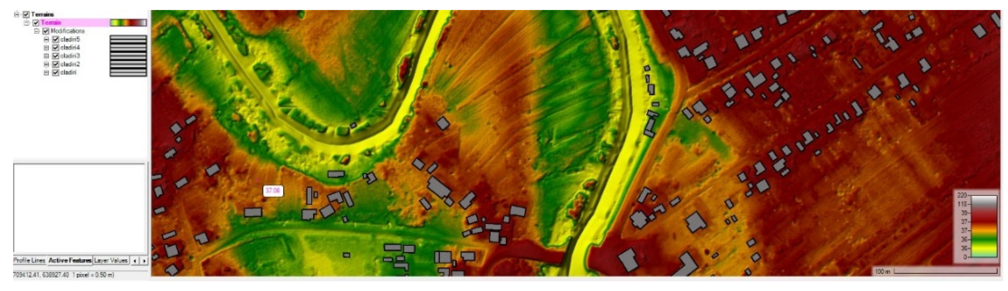
Figure 11.
Footprint of the buildings in the flooded area.
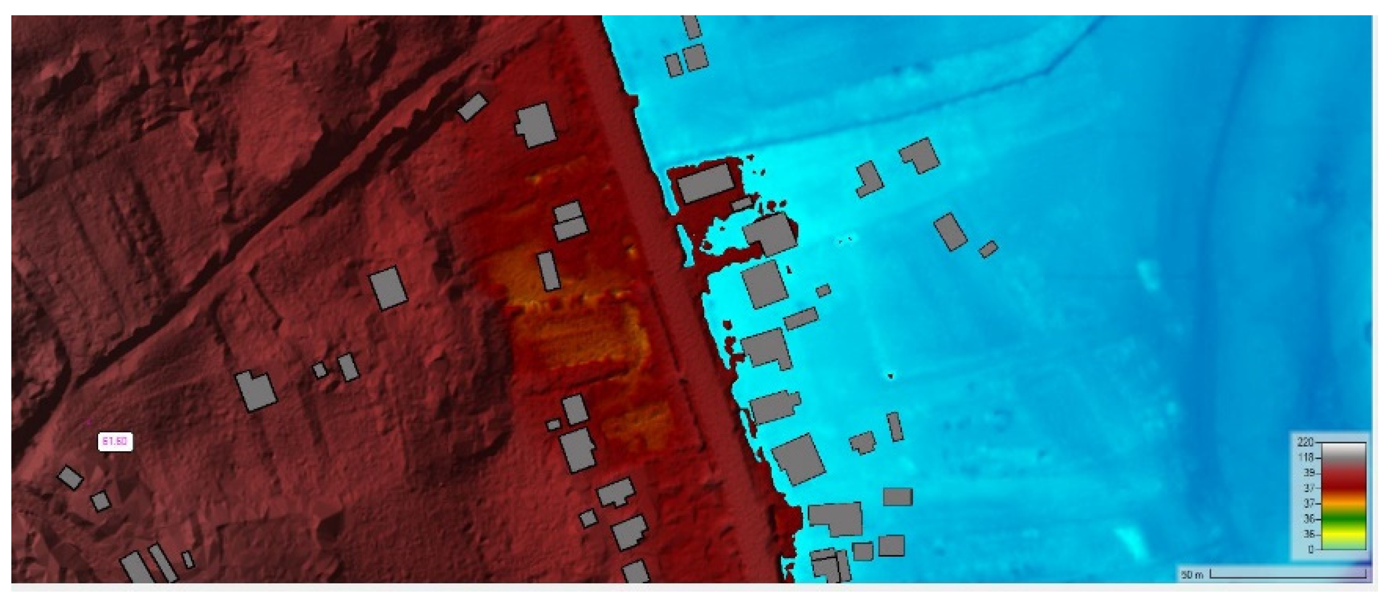
Figure 12.
Manning's roughness coefficient table in RAS Mapper.
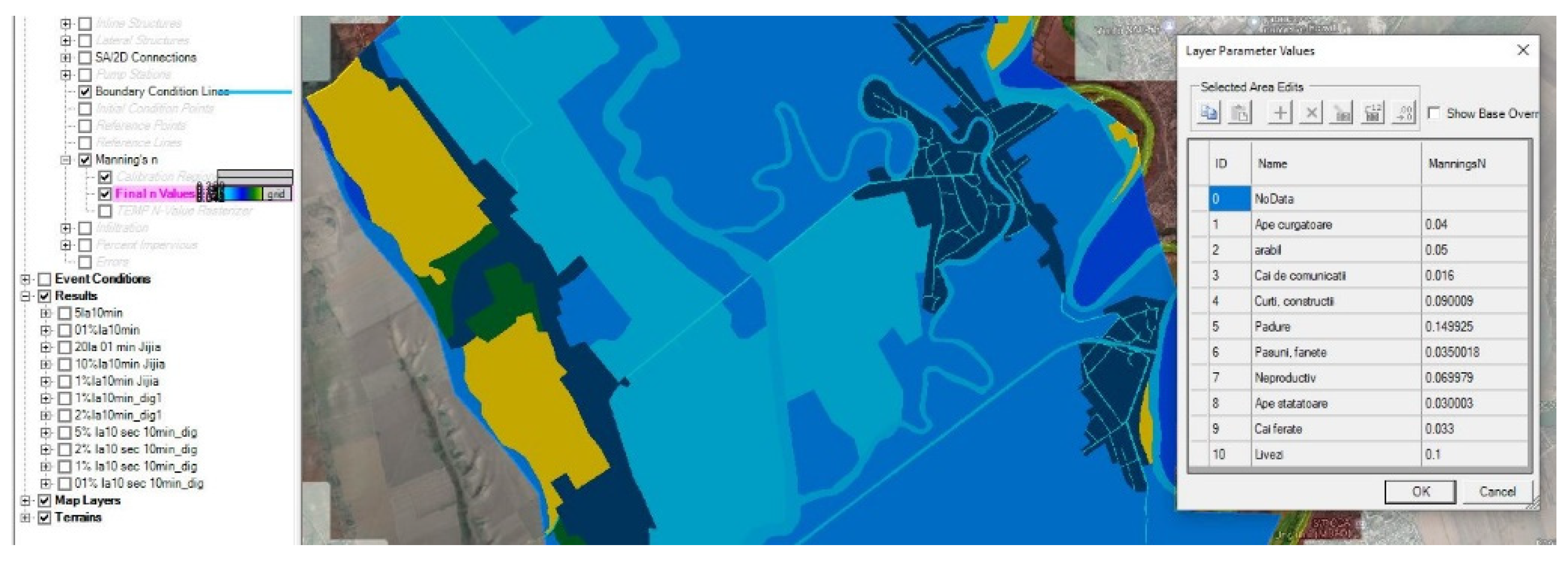
Figure 13.
Associating the Land Cover layer with the Land Geometry.
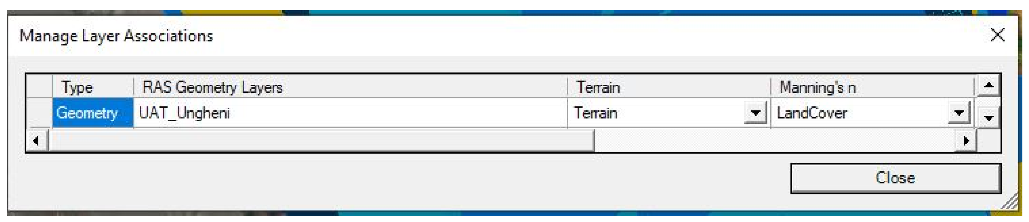
Figure 14.
Calculation grid.
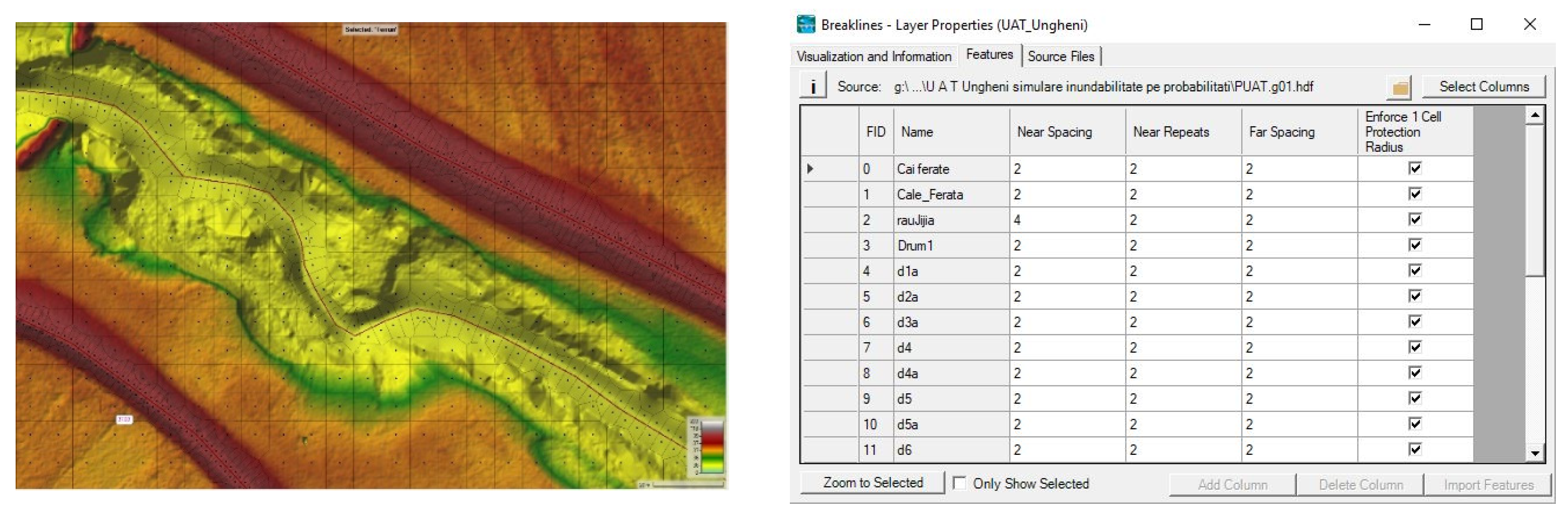
Figure 15.
Model run.
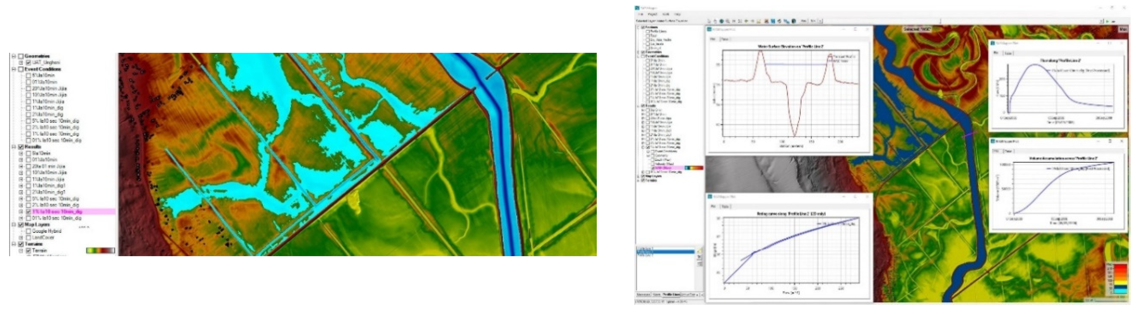
Figure 16.
Flood hazard map.
Disclaimer/Publisher’s Note: The statements, opinions and data contained in all publications are solely those of the individual author(s) and contributor(s) and not of MDPI and/or the editor(s). MDPI and/or the editor(s) disclaim responsibility for any injury to people or property resulting from any ideas, methods, instructions or products referred to in the content. |
© 2024 by the authors. Licensee MDPI, Basel, Switzerland. This article is an open access article distributed under the terms and conditions of the Creative Commons Attribution (CC BY) license (http://creativecommons.org/licenses/by/4.0/).
Copyright: This open access article is published under a Creative Commons CC BY 4.0 license, which permit the free download, distribution, and reuse, provided that the author and preprint are cited in any reuse.


