Submitted:
24 April 2024
Posted:
01 May 2024
You are already at the latest version
Abstract
Urbanization-induced land use transition results in a decline in ecosystem services, which has implications for regional ecological security. In order to explore the relationship between ecosystem services and land use transition, this paper utilizes the InVEST model, geographically weighted regression model to examine the impact of land use transition on ecosystem services in the Dongting Lake area (DLA). The results showed that (1) During the period 2000-2020, the intensity and motivation of land-use transition showed obvious spatial and temporal heterogeneity with the variation of urbanization development. (2) Habitat quality and Carbon sequestrations showed a downward trend. In contrast, food supply followed an upward trend; soil conservation and water yield services initially increased and dropped later. The overall spatial changes in habitat quality and Carbon sequestration appear to be insignificant. Food supply shows significant differences in the plains compared to other areas; while soil conservation and water yield service shows significant changes in places other than the DLA. (3) From 2000 to 2020, land use transition dynamics, population density, GDP density, night lighting and transition intensity had mainly negative effects on ecosystem services. Only the Normalized Vegetation Index (NDVI) showed a positive effect on ecosystem services. The results of the research will provide valuable references for the development and implementation of spatial ecological restoration planning and land use policies in the national territory.
Keywords:
ecosystem service
; Dongting Lake area
; land use transitions
; InVEST model
; GWR
1. Introduction
Since the 21st century, with growing urbanization and industrialization [1], the large-scale growth of building land has led to noticeable shifts in land use, in which natural and semi-natural habitats classes have shifted towards artificial habitats classes. In addition, current research has identified habitat fragmentation, soil quality deterioration, and increasing environmental contamination as direct effects of human over-exploitation [2]. These repercussions are predominantly driven by land use transition (LUT), which considerably alters the balance between the supply and demand of ESs, leading to changes in their providing ecosystem functions [3]. Therefore, disclosing the impacts on ESs in the process of LUT is vital for the creation and implementation of ecological restoration planning and land use regulations in the territorial area.
LUT is the result of the interaction between social and natural factors and plays an important role in regulating socioeconomic development and ecological restoration [4]. The meaning of change, its effects, and other facets have been the subject of several academic studies.Explicit and implicit LUT modes are distinguishable among them based on their respective connotations [5]. Implicit LUT, on the other hand, primarily refers to changes in land use functions, including various land attributes in terms of property rights, inputs, outputs, production, etc. Among them, explicit LUT refers to changes in land use structure (i.e., quantitative and spatial structure) [6,7].In terms of effect, LUT has caused changes in land use structure, which has led to the reduction of ecological land, thus causing ecological environment damage [8]. Among them are ESs, which people rely on for direct or indirect environmental benefits. Research has demonstrated that ESs are a key component of ecological security [9]. Natural variables like temperature and rainfall, as well as socioeconomic factors like population growth, construction site expansion, and economic development, all have an impact on ESs [10]. Of these, land use change has a major impact on ESs [11]. Prior research has mostly examined how changes in land use structure affect ESs without taking into account how these changes affect ESs themselves during the LUT process [12]. Furthermore, research on the effects of changing land use on ESs is primarily conducted at the administrative division level [13,14,15]. This limits the ability to suggest relevant planning for the area and makes it challenging to characterize the phenomenon’s local changes.
The DLA is an important part of the Yangtze River Basin and an important area for ecological restoration and food supply in China. The urbanization process has led to a drastic transition of land use in the area and has had a serious impact on area ESs. Therefore, this study takes the DLA as the research object, reveals the land use transition and ESs on the grid scale from 2000 to 2020 in a multi-dimensional measurement, and explores the impact mechanism of land use transition on ESs using a geodetector model, with the aim of answering the following scientific questions: (1) What is the pattern of change in ESs under the process of land use transition? (2) How does LUT affect ESs? In order to provide theoretical support for the high-quality development of land space in the DLA. In order to give theoretical support for the high-quality development of land space in the DLA [16].
2. Materials and Methods
2.1. Study Area
DLA (28°30′N-29°40′N, 113°10′E-114°40′E) is the second largest freshwater lake in China [17]. It is located in the northern part of Hunan Province and the southern part of Hubei Province, as well as an essential storage lake and ecological security function area in the Yangtze River basin [18]. This area is overall dominated by plains, which can be broadly classified into four types: lake water bodies and shoals, plains around the lake, hills and low mountains around the lake area, valley plains and hills [19]. The present investigation focused on a subset of 19 counties (cities and districts) from the three prefecture-level cities of Yueyang, Yiyang, and Changde in the DLA [20]. These included Yueyang City, Linxiang City, Yueyang County, Huarong County, Miluo City, Xiangyin County, Yiyang City, Yuanjiang City, Nan County (including the Datong Lake area), Changde City, Hanshou County, Anxiang County, Li County, Jin City, and Linli County [21]. As shown in Figure 1, the total area is about 25,800 km2, occupying 12.18% of Hunan Province. By the end of 2020, the resident population is about 10,705,800, which is about 16.11 per cent of the province. The GDP reached 710.44 billion yuan, with approximately 17 % of the province.
2.2. Data Sources and Processing
2.2.1. Data Sources
The data mainly include land use data, food supply, carbon density, night light data, and others, as shown in Table 1.
2.3. Methodology
2.3.1. Land Use Transition Intensity (LUI)
LUI is an important metric of land use function [27]. From a socio-economic standpoint, LUI can indicate varied degrees of land transitions, development, and exploitation. The study will take each land raster as a sampling point, generate a 1 km × 1 km grid, and calculate the LUI of each grid independently. As in Figure 3. Each land use type, It can be defined as the ability of different land use types to provide products and services to for human beings [22]. Their contribution to LUI is consistent with their weights. Therefore, by using the grid, LUI can be calculated by the following formula:
Here, represents the total land area, is the number of land use types (n=6 in this study), is the area of each land use type, and is the value of the degree of exploitation of the land use type [27]. LUI can be classified into four categories, each of the land use types within each category has the same value. Specifically, the value of industrial, urban and rural-urban land, which known as build-up land, is defined as “4”. It is the main carrier of social and economic activities in human history; Farmland has a value of “3” since this land use type has both socio-economic and natural attributes. The Chinese Government reinforces the protection of farmland, grassland and woodland resources owing to their ecological functions [9], which are assigned a value of 2; Bare land is valued at “1”, as such land has yet to be developed for socio-economic activities.
2.3.2. Land Use Dynamics model (LUD)
LUD can describe the rate and trend of land transition and reflect its overall characteristics within a region in the time dimension [28]. Similarly, this paper uses the grid as the basic unit for LUD calculation. The specific equations are given below [29]:
Here, is the total land area; n is the number of land use types (n=6 in this study), and is the area where land use type i is transformed into land use type j [31]. The difference between and represents the time of the study. Broadly speaking, the larger the LUD, the faster and larger the land use transition. The trend will also be more pronounced, and vice versa.
2.3.3. Methods for Quantifying Ecosystem Services (ESs)
ESs can be categorised into four types: provisioning services (providing food and water), regulating services (controlling floods and diseases), cultural services (spiritual, entertainment, and cultural benefits), and supporting services (nutrient cycling that maintains the environment for life on earth) [32]. In this study, Carbon sequestration, water yield services, food production, habitat quality, and soil conservation were selected. Among them, Carbon sequestration and soil conservation are regulating services; Water yield services and food production belong to supply services; and habitat quality is a supporting service. The specific measurement formula is shown in Table 2.
2.3.4. Geographically Weighted Regression (GWR)
GWR model is a classic model for analysing spatial heterogeneity. It captures the effect of geographical location on the relationship between dependent and independent variables. Compared with other models GWR has higher accuracy. And the ecosystem service observation data in this paper are spatially correlated. Therefore, the temporal attributes in the geographically weighted regression are linked to the spatial attributes, which reflects the spatio-temporal drive mechanism of the explanatory power of the independent variable on the dependent variable. The specific formula of the GWR model is presented below:
Where, is ecosystem services (ESs) in grid ij, a normalised means of 5 categories of ecosystem services; represents the spatial and temporal coordinates of sampling point i; is the regression constant for sampling point i; represents the k th regression parameter for sample point i; is the driving factor k for sampling point i; and is the residual term of the model.
3. Results
3.1. Characteristics of Spatial and Temporal Changes in LUT
Overall, the LUI fluctuates slightly, with average values of 237.99, 235.82 and 238.92 in 2000, 2010 and 2020, of which the average annual growth rate of the LUI from 2000 to 2010 is -0.22 and that from 2010 to 2020 is 0.31. On the contrary, LUD shows a trend of increasing and then decreasing, and the average values of 2000-2010 and 2010-2020 are 5.58 and 5.62, respectively. The spatial land use dynamics The high value areas in 2000-2010 are mainly around the lake area and in the urban expansion area; the high value areas in 2010-2020 are mainly dispersed in the urban and rural areas as well as in the urban expansion area (see Figure 2). The distribution of high value areas of land use transition intensity in 2000, 2010 and 2020 is concentrated in the DLA, which indicates that the topography of the region is good and the land resources are fully utilized.
From 2000 to 2010, the high-value area of LUD for land use transition motivation was mainly concentrated in the eastern coastal area at the northern end of DLA and in Urban construction areas around the area; while from 2010 to 2020, the high-value area of LUD for land use transition motivation is mainly concentrated in the suburbs of the cities and urban and rural areas, especially the townships and townships around the cities, with a large range of land use changes and slowing down of the change motivation around the lake area (see Figure 3).
3.2. Characteristics of Spatial and Temporal Changes in ESs
The temporal and spatial variations over the period 2000-2020 for different ESs. As shown in Table 3 and Figure 4, the mean value of WY increased from 490.18 mm in 2000 to 902.01 mm in 2010. High-value areas are distributed in the southeastern and southern hilly areas; low-value areas are spread in the waters of the DLA. The mean value of WY increased from 902.01 mm in 2010 to 690.10 mm in 2020. High-value areas are sporadically scattered; low-value areas are still distributed in the waters of the DLA. The average value of CS decreases from 2289. 35t/hm2 in 2000 to 2255. 01t/hm2 in 2010, and the high-value areas are distributed in the hilly areas and the DLA, while the low-value areas are distributed in the plains. The average value of CS in 2010 decreased from 2255. 01t/hm2 to 2247. 46t/hm2 in 2020. High values are still distributed in the hilly mountainous areas and the DLA; low values are distributed in the built-up areas and in part of the waters of the DLA. the average value of SC in 2000 increased from 1088. 32t/ha2/ha2 to 1822.64t/ha2/ha2 in 2010. High values are distributed in the mountainous areas at the edges of the study area; low values are distributed in the DLA. The mean value of SC increased from 1088.32t/ha2/ha2 in 2000 to 1822. 64t/ha2/ha2 in 2010. High value areas were distributed in the marginal mountains of the study area; low value areas were distributed in the watershed of DLA. The mean value of SC decreased from 1822. 64t/ha2/ha2 in 2010 to 626. 29t/ha2/ha2 in 2020. High value areas were distributed in the marginal mountains; low value areas were distributed in the watershed of DLA. The mean value of HQ decreased from 0.71 in 2000 to 0.71 in 2020. The mean value of HQ decreased from 0.71 in 2000 to 0.697 in 2010. High-value areas are distributed in the marginal mountains of the study area as well as in the DLA; low-value areas are distributed in the urban areas. the mean value of HQ decreased from 0.697 in 2010 to 0.695 in 2020. High-value areas are still distributed in the marginal mountains as well as in the DLA; low-value areas are still distributed in the urban areas. The mean value of FP decreased from 47,408,555.0 in 2000 to 0.695 in 2020. The average value of FP increased from 4740855.49 KJ in 2000 to 6024647.79 KJ in 2010. High-value areas were distributed in the plains and hills of the DLA; low-value areas were distributed in the marginal mountains of the study area and in the DLA. The average value of FP in 2010 increased from 60246447.79 KJ to 7036502.47 KJ in 2020. High-value areas are still distributed in the DLA. The high-value areas are still distributed in the plains and hills of the DLA; the low-value areas are still distributed in the mountains at the edge of the study area and in the DLA.
3.3. Spatial and Temporal Correlation between LUT and ESs
The regression parameters of TES between and socio-economics are less variable than those between natural ecological factors (e.g., Figure 5 and Figure 6). The regression coefficients of NDVI ranged from -0.097836 to 0.208317, with the largest changes in regression coefficients and significant spatial heterogeneity. During the period of 2000-2010, 85% of the grids consisted of negative coefficient spaces, whereas the positive coefficient spaces were distributed in the southwest of DLA; between 2010 and 2020, the proportion of negative coefficient spaces decreased significantly, while positive coefficient spaces were distributed in the east coast, the western basin and the southern edge of the study area.
The regression coefficients of LUD ranged from -0.001908 to 0.000521.The magnitude of change of the regression coefficients varied slightly, and the spatial heterogeneity turned out to be weaker. During 2000-2010, 60% of the grids were negative coefficient spaces, and relatively positive coefficient spaces were mainly distributed in the southern part of DLA, the southwestern edge and the northwestern part of the study area.From 2010 to 2020, the positive coefficient spaces varied significantly, and the proportion of negative coefficient spaces increased substantially. Positive coefficient space is mainly distributed in the southwestern part and the northeastern part of the study area.
In addition, the regression coefficients of LUI ranged from -0.000593 to 0.000370, with small variations and weak spatial heterogeneity.The positive coefficients for the period of 2000-2010 were mainly in the southern and eastern parts of DLA, as well as the western and northeastern fringes of the study area.For the period of 2010-2020, the high value areas were mainly in the northeastern and southwestern parts of the study area as well as in the south of DLA.
The socio-economic data include population density, GDP density and night light data. The regression coefficients of the nighttime light data were -0.002690~0.002625. Spatially, the high values from 2000 to 2010 were mainly concentrated in the east, south and north of DLA, and the southern part of the western watershed and the northern edge of the study area; Whereas, the high values in 2010-2020 were mainly in the northern, southeastern and southwestern parts of DLA as well as the northwestern and western edges of the study area. For GDP density, the regression coefficients were -0.000008~0.000024. The high values in 2000-2010 were distributed in the southern part of the study area; the high values in 2010-2020 were mainly in the direction of the northwestern part of DLA. The regression coefficients of population density were -0.000008~0.000011, and the high value areas in 2000-2010 were mainly distributed in the northwestern part of the study area and the western part of the DLA; the high value areas in 2010-2020 were mainly distributed in the western and northwestern parts of the study area as well as in the southern part.
4. Discussion
4.1. Impacts of Land Use Transition on Ecosystems under Different Perspectives
The structure of ecosystems (e.g., cropland, woodland, etc.) and processes (e.g., habitat quality) in the process of land-use transition are affected by human-social factors, which transform natural ecosystems to maximize human benefits [36]. Meanwhile, the process of land use transition affects the socio-economic characteristics correspondingly, as demonstrated by the growth of night-time lighting data, population density and GDP density after the expansion of urban construction land [37]. As shown in Figure 4, habitat quality and Carbon sequestration show a downward trend, while food supply trends upward; soil conservation and water yield services initially increase and then decrease. During the period 2000-2010, the eastern littoral area at the northern of DLA underwent a dramatic land transition. It is mainly due to the introduction of policies related to the return of farmland to the lake and forests in 2002, which reduced human occupation of land in the lake area. This is followed by the expansion of land for urban construction, in which China experienced a high rate of development in this decade, with rapid growth in urban, rural and city areas.
Land use transition (LUT) has an impact not only on human life and socioeconomic characteristics, but also on the regional spatial environment [38]. This research used a micro grid scale to explore the fact that ecosystem services in neighbouring regions are strongly correlated. The spillover effect makes land use transition affect ecosystem services not only within the same region but also in neighbouring regions [39]. This study explores the effects of spatial spillovers on ecosystem service types at a grid scale, with different combinations of influencing factors that enhance the persuasive power of geographically weighted regression (GWR). The results also showed that while sensible land use would enhance ESs in nearby areas, socio-economic development would inevitably lead to a rise in transition intensity. Furthermore, the LUI exhibited a negative spatial correlation with the majority of ES at the grid scale. After 2013, the area had a sharp increase in both urban and rural development, and as a result of the loss of forest land and the accumulation of rural dwelling land, SC services started to diminish. High-value areas of LUD are primarily concentrated in areas with infrequent human activities, primarily in areas with higher elevation and lower LUI and LUD. In contrast, the distribution pattern of high-value areas of SC is different. These include LUD, which has a negative correlation with it, and the more homogeneous the land structure with more intact soil, primarily composed of forested land.
4.2. Adjustment of Land Use Transition
In 2000-2010, the central and northern parts of DLA experienced a dramatic land use transition. It is manifested in the shift of farmland and construction land, followed by a decrease in the intensity of LUT. This phenomenon is different from the land use transition (LUT) in developed Western countries, which is mainly driven by market mechanisms [40]. Urbanisation in China, defined by its scale and efficiency, is dominated by multiple levels of government [41], which leads to the emergence of clustered spaces. During the period 2010-2020, the transition has slowed down. Thus, the dynamics of land use declined, spreading in suburban areas. This is the result of industrial reorganization and competition between ecological and artificial land use. Ultimately, it makes the land use structure complicated and thus reduces the intensity of LUT. Under the impetus of the rural revitalization strategy, land-use subjects tend to adjust the land use structure through economic approaches such as land rent or price to control the speed of agricultural land transition [42], which could reduce the intensity of LUT. Considering the variability of rural conditions, the transition should be slow and long-lasting, which is compatible with the general characteristics of transition in rural areas [43]. The study reveals that land use transition is a mirror of social development. A comprehensive and scientific LUT system can promote integrated urban-rural development and provide a reference. In this regard, the land use dynamic model measures the dynamics and trends of land use transition in the time dimension. It reacts to the efficiency and effectiveness of policy implementation through the case of ecological protection of DLA. For instance, in the riverfront development along the Yangtze River in China, the promotion of ecological protection and remediation of the Yangtze River Basin and the riverfront wetland protection project in the last decade [44] has provided a rapid improvement in LUT and ESs.
The actual situation of land use can be more realistically reflected in the 1km grid scale. It can enhance the credibility for the spatial and temporal changes between LUT and various ESs in the GWR model. Moreover, population density, night light data and GDP density are assessed from a socioeconomic perspective, which can responds a certain accessibility of human living and production space. At the same time these anthropogenic factors produce single or multiple impacts on ecosystem services. The complexity and heterogeneity of anthropogenic disturbances in different regions further enhance the diversity of ecosystem service distribution patterns and regional formation mechanisms, especially in urban agglomerations characterised by complex internal structures [45]. Although this may have been recognised in previous studies, the coexistence of diversity and heterogeneity of anthropogenic impacts has been overlooked.
4.3. Innovative Points and Outlook
To explore the impact of LUT on the spatial and temporal changes of ecosystem services, this paper select geographically weighted regression (GWR) to reflect the partial spatial characteristics. Among them, mountainous areas and waters are intuitively more sensitive than built-up areas, which makes the variation of ecosystem services related to carbon sequestration and water yield services different from other areas. This in turn affects the median values of the corresponding coefficients of variation, which are usually used to characterize the overall GWR results [46]. Future studies should refine the limitations of quantitative methods for the sake of data accuracy. For example, this study measured five types of ecosystem services, which cannot fully reflect the regional ecosystem pattern. In addition, factors such as ecological protection policies should be considered in the future to improve the mechanism of ecosystem service changes.
5. Conclusions
In this paper, DLA is selected as the research object. Based on grid scale, we used InVEST and GWR regression models to analyse the impact of LUT on ESs in the study area from 2000 to 2020.The main conclusions are as follows:
During the period 2000-2020, the rapid expansion of construction land in the study area led to a significant LUT. The result demonstrates that the mean value of intensity changed from 237.99 in 2000 to 238.92 in 2020. In particular, The high intensity of LUT is mainly distributed around the DLA, while the low intensity is mainly distributed in the mountainous areas at the edge of the area. Additionally, the dynamics of LUT changed from 5.58 in 2000-2010 to 5.62 in 2010-2020. Among them, the high dynamics in 2000-2010 were mainly distributed in the coastal areas in the northeastern part of DLA and urban construction areas. Whereas the high dynamics in 2010-2020 were mainly located in the outskirts of the cities and rural areas.
Different types of ecosystem services displayed spatial and temporal heterogeneity. To be specific, carbon sequestration services, habitat quality services, and soil conservation have similar spatial characteristics, and the high values are primarily distributed in high-elevation mountain areas. In contrast, food production services presented the opposite features, with high values mainly distributed in plain areas; Soil conservation declined first and then ascended. The low values of water services are related to the distribution of watersheds.
There are differences in the factors that influence ecosystem services in different periods. Compared with 2010-2020, NDVI coefficients had the largest value of change in 2000-2010 and the strongest impact on ecosystem services. Notably, the high values in 2000-2010 converge on the west side of DLA, while the high value areas in 2010-2020 are scattered all over the research area. Furthermore, LUI and LUD have more grids with high values in 2000-2010, but the number of grids with high values decreases in 2010-2020; The NLI has a higher impact coefficient in the high value range of 2000-2010 compared to 2010-2020. While GDP and POP have the smallest coefficients, which means that they have the lowest explanatory validity compared to other impact factors. In general, the findings have significant implications for understanding the relationship and evolutionary processes between land use transition and ecosystem services.
Supplementary Materials
The following supporting information can be downloaded at the website of this paper posted on Preprints.org,
Author Contributions
Conceptualization, Q.N.; methodology and software, investigation, writing—original draft, X.S.; writing—review and editing, Q.N.; supervision, Q.N. All authors have read and agreed to the published version of the manuscript.
Funding
This work was supported by the National Natural Science Foundation of China [grant number U1867221]. Hunan Natural Science Foundation project[grant number 2022JJ50271].
Data Availability Statement
Data is contained within the article or Supplementary Material.
Conflicts of Interest
The authors declare no conflicts of interest.
References
- Wang, Z.; Fu, H.; Liu, H.; Liao, C. Urban development sustainability, industrial structure adjustment, and land use efficiency in China. Sustain. Cities Soc. 2023, 89, 104338. [Google Scholar] [CrossRef]
- Balkanlou, K.R.; Müller, B.; Cord, A.F.; Panahi, F.; Malekian, A.; Jafari, M.; Egli, L. Spatiotemporal dynamics of ecosystem services provision in a degraded ecosystem: A systematic assessment in the Lake Urmia basin, Iran. Sci. Total. Environ. 2020, 716, 137100. [Google Scholar] [CrossRef]
- Keyes, A.A.; McLaughlin, J.P.; Barner, A.K.; Dee, L.E. An ecological network approach to predict ecosystem service vulnerability to species losses. Nat. Commun. 2021, 12, 1–11. [Google Scholar] [CrossRef]
- Cao, Y.; Kong, L.; Zhang, L.; Ouyang, Z. The balance between economic development and ecosystem service value in the process of land urbanization: A case study of China’s land urbanization from 2000 to 2015. Land Use Policy 2021, 108, 105536. [Google Scholar] [CrossRef]
- Shi, Y.; Feng, C.-C.; Yu, Q.; Guo, L. Integrating supply and demand factors for estimating ecosystem services scarcity value and its response to urbanization in typical mountainous and hilly regions of south China. Sci. Total. Environ. 2021, 796, 149032. [Google Scholar] [CrossRef] [PubMed]
- Burton, M.L.; Samuelson, L.J.; Mackenzie, M.D. Riparian woody plant traits across an urban–rural land use gradient and implications for watershed function with urbanization. Landsc. Urban Plan. 2009, 90, 42–55. [Google Scholar] [CrossRef]
- de Groot, R. Function-analysis and valuation as a tool to assess land use conflicts in planning for sustainable, multi-functional landscapes. Landsc. Urban Plan. 2006, 75, 175–186. [Google Scholar] [CrossRef]
- Yang Qingke, DUAN Xuejun, WANG Lei, JIN Zhifeng. Land use transformation and ecological environment effect based on “Three-life space” : A case study of the core area of the Yangtze River Delta [J]. Scientia Geographica Sinica,2018,38(01):97-106.
- Liu, C., Y. Liu, B. F. Giannetti, C. M. V. B. Almeida, F. Sevegnani & R. Li (2023) Spatiotemporal differentiation and mechanism of anthropogenic factors affecting ecosystem service value in the Urban Agglomeration around Poyang Lake, China. Ecological Indicators, 154, 110733.
- Biggs, N.B. Drivers and constraints of land use transitions on Western grasslands: insights from a California mountain ranching community. Landsc. Ecol. 2022, 37, 1185–1205. [Google Scholar] [CrossRef] [PubMed]
- Ouyang Xiao, Wang Kun, Wei Xiao. The impact of the correlation between urban and rural construction land on ecosystem services: A case study of Dong ting Lake area [J].Acta ecologica sinica, 2022, and (21) : 8713-8722.
- Xu D X, Wu F, He L H, Liu H J, Jiang Y. Impact of land use change on ecosystem services: Case study of the Zhangjiakou-Chengde area. Acta Ecologica Sinica, 2019, 39(20): 7493-7501.
- Bai, Y.; Chen, Y.; Alatalod, J.M.; Yang, Z.; Jiang, B. Scale effects on the relationships between land characteristics and ecosystem services- a case study in Taihu Lake Basin, China. Sci. Total. Environ. 2020, 716, 137083. [Google Scholar] [CrossRef]
- Liu, J.Y. , 1996. The Macro Investigation and Dynamic Research of the Resource and Environment. China Science and Technology Press, Beijing.
- Song, X.; Liu, Y.; Zhu, X.; Cao, G.; Chen, Y.; Zhang, Z.; Wu, D. The impacts of urban land expansion on ecosystem services in Wuhan, China. Environ. Sci. Pollut. Res. 2022, 29, 10635–10648. [Google Scholar] [CrossRef]
- Li, S.; Jiang, C.; Ma, Y.; Li, C. Spatiotemporal Analysis of Hydrometeorological Factors in the Source Region of the Dongting Lake Basin, China. Atmosphere 2023, 14, 1793. [Google Scholar] [CrossRef]
- Song, X.; Liu, Y.; Zhu, X.; Cao, G.; Chen, Y.; Zhang, Z.; Wu, D. The impacts of urban land expansion on ecosystem services in Wuhan, China. Environ. Sci. Pollut. Res. 2022, 29, 10635–10648. [Google Scholar] [CrossRef]
- Liu, C.; Deng, C.; Li, Z.; Liu, Y. Response Characteristics of Soil Erosion to Spatial Conflict in the Production-Living-Ecological Space and Their DrivingMechanism: A Case Study of Dongting Lake Basin in China. Land 2022, 11, 1794. [Google Scholar] [CrossRef]
- Zhao, Y.; Luo, J.; Li, T.; Chen, J.; Mi, Y.; Wang, K. A Framework to Identify Priority Areas for Restoration: Integrating Human Demand and Ecosystem Services in Dongting Lake Eco-Economic Zone, China. Land 2023, 12, 965. [Google Scholar] [CrossRef]
- Jiang, L.; Zeng, Z. Analysis of Flood Water Level Variation in the Yichang–Chenglingji Reach of the Yangtze River after Three Gorges Project Operation. Water 2024, 16, 841. [Google Scholar] [CrossRef]
- Jie, N.; Cao, X.; Chen, J.; Chen, X. A New Method for Identifying the Central Business Districts with Nighttime Light Radiance and Angular Effects. Remote. Sens. 2022, 15, 239. [Google Scholar] [CrossRef]
- Wang Zhiyuan, Wan Ding, Liao Jianjun, et al. Ecological environment effect and driving factors of transformation of“Production-Living-Eco-logical Space”in Dong ting Lake eco-economic zone[J]. Science Technology and Engineering, 2023, 23(9): 3876-3888.
- Wentland, S.A.; Ancona, Z.H.; Bagstad, K.J.; Boyd, J.; Hass, J.L.; Gindelsky, M.; Moulton, J.G. Accounting for land in the United States: Integrating physical land cover, land use, and monetary valuation. Ecosyst. Serv. 2020, 46, 101178. [Google Scholar] [CrossRef]
- Biggs, N.B. Drivers and constraints of land use transitions on Western grasslands: insights from a California mountain ranching community. Landsc. Ecol. 2022, 37, 1185–1205. [Google Scholar] [CrossRef]
- Terrado, M., S. Sabater, B. Chaplin-Kramer, L. Mandle, G. Ziv & V. Acuña (2016) Model development for the assessment of terrestrial and aquatic habitat quality in conservation planning. Science of The Total Environment, 540, 63-70.
- Wang, Y., E. Dai, L. Yin & L. Ma (2018) Land use/land cover change and the effects on ecosystem services in the Hengduan Mountain area, China. Ecosystem Services, 34, 55-67.
- Qi, Y.; Wang, R.; Shen, P.; Ren, S.; Hu, Y. Impacts of Land Use Intensity on Ecosystem Services: A Case Study in Harbin City, China. Sustainability 2023, 15, 14877. [Google Scholar] [CrossRef]
- El-Naggar, A.; Zhou, R.; Tang, R.; Hur, J.; Cai, Y.; Chang, S.X. Rice Husk and Its Biochar Have Contrasting Effects on Water-Soluble Organic Matter and the Microbial Community in a Bamboo Forest Soil. Land 2022, 11, 2265. [Google Scholar] [CrossRef]
- Kleijn, D. , Kohler, F., B’ aldi, A., Bat´ ary, P., Concepci´on, E.D., Clough, Y., Díaz, M., Gabriel, D., Holzschuh, A., Knop, E., Kov´ acs, A., Marshall, E.J.P., Tscharntke, T., Verhulst, J., 2009. On the relationship between farmland biodiversity and land-use intensity in Europe. Proc. R. Soc. B 276, 903–909. [CrossRef]
- Li, P., D. Zuo, Z. Xu, R. Zhang, Y. Han, W. Sun, B. Pang, C. Ban, G. Kan & H. Yang (2021) Dynamic changes of land use/cover and landscape pattern in a typical alpine river basin of the Qinghai-Tibet Plateau, China. Land Degradation & Development, 32, 4327-4339.
- Biłozor, A.; Cieślak, I.; Czyża, S.; Szuniewicz, K.; Bajerowski, T. Land-Use Change Dynamics in Areas Subjected to Direct Urbanization Pressure: A Case Study of the City of Olsztyn. Sustainability 2024, 16, 2923. [Google Scholar] [CrossRef]
- MA Lin, LIU Hao, PENG Jian, WU Jiansheng. A review of ecosystem services supply and demand[J]. Acta Geographica Sinica, 2017, 72(7): 1277-1289.
- Cong, W., X. Sun, H. Guo & R. Shan (2020) Comparison of the SWAT and InVEST models to determine hydrological ecosystem service spatial patterns, priorities and trade-offs in a complex basin. Ecological Indicators, 112, 106089.
- Sancho Santos, M. E., Š. Eva, H. Pavel & S. Christoph (2021) Comment on “Diluted concentrations of methamphetamine in surface water induce behavior disorder, transgenerational toxicity, and ecosystem-level consequences of fish” by Wang et al. [Water Research 184 (2020) 116-164]. Water Research, 197, 117007.
- Williams, J.R. , Jones, C.A., Dyke, P.T., 1984. A modeling approach to determining the relationship between erosion and soil productivity. Trans. ASAE. 27, 129–144.
- LONG Hualou, CHEN Kunqiu. Urban-rural integrated development and land use transitions: A perspective of land system science. Acta Geographica Sinica[J], 2021, 76(2): 295-309. [CrossRef]
- Song Xiaoqing. Research framework of land use transition. Acta Geographica Sinica, 2017, 72 (03): 471-487.
- Dong J H, Zhang Z B, Da X J, Zhang W B, Feng X L. Eco-environmental effects of land use transformation and its driving forces from the perspective of “production-living-ecological” spaces: a case study of Gansu Province. Acta Ecologica Sinica, 2021, 41(15): 5919-5928.
- Feng, X., Y. Li, X. Wang, J. Yang, E. Yu, S. Wang, N. Wu & F. Xiao (2023) Impacts of land use transitions on ecosystem services: A research framework coupled with structure, function, and dynamics. Science of The Total Environment, 901, 166366.
- Zank, B.; Bagstad, K.J.; Voigt, B.; Villa, F. Modeling the effects of urban expansion on natural capital stocks and ecosystem service flows: A case study in the Puget Sound, Washington, USA. Landsc. Urban Plan. 2016, 149, 31–42. [Google Scholar] [CrossRef]
- Yuan, F.; Wei, Y.D.; Chen, W. Economic transition, industrial location and corporate networks: Remaking the Sunan Model in Wuxi City, China. Habitat Int. 2014, 42, 58–68. [Google Scholar] [CrossRef]
- Ning, Q. & X. Ouyang (2023) Spatio-temporal characteristics and mechanism of ecological degradation in a hilly southern area—a case study of Dong ting Lake Basin. Environmental Science and Pollution Research, 30, 45274-45284.
- Gomersall, K. Governance of resettlement compensation and the cultural fix in rural China. Environ. Plan. A: Econ. Space 2021, 53, 150–167. [Google Scholar] [CrossRef]
- Duan, X., H. Zou, L. Wang, W. Chen & M. Min (2021) Assessing ecological sensitivity and economic potentials and regulation zoning of the riverfront development along the Yangtze River, China. Journal of Cleaner Production, 291, 125963.
- Liu, C., Y. Liu, B. F. Giannetti, C. M. V. B. Almeida, F. Sevegnani & R. Li (2023) Spatiotemporal differentiation and mechanism of anthropogenic factors affecting ecosystem service value in the Urban Agglomeration around Poyang Lake, China. Ecological Indicators, 154, 110733.
- Chen, W., G. Chi & J. Li (2019) The spatial association of ecosystem services with land use and land cover change at the county level in China, 1995–2015. Science of The Total Environment, 669, 459-470.
Figure 1.
Geographic location and land use classification of DLA (DEM in the figure is a digital elevation model, which is a discrete mathematical depiction of the topography of the earth’s surface).
Figure 1.
Geographic location and land use classification of DLA (DEM in the figure is a digital elevation model, which is a discrete mathematical depiction of the topography of the earth’s surface).
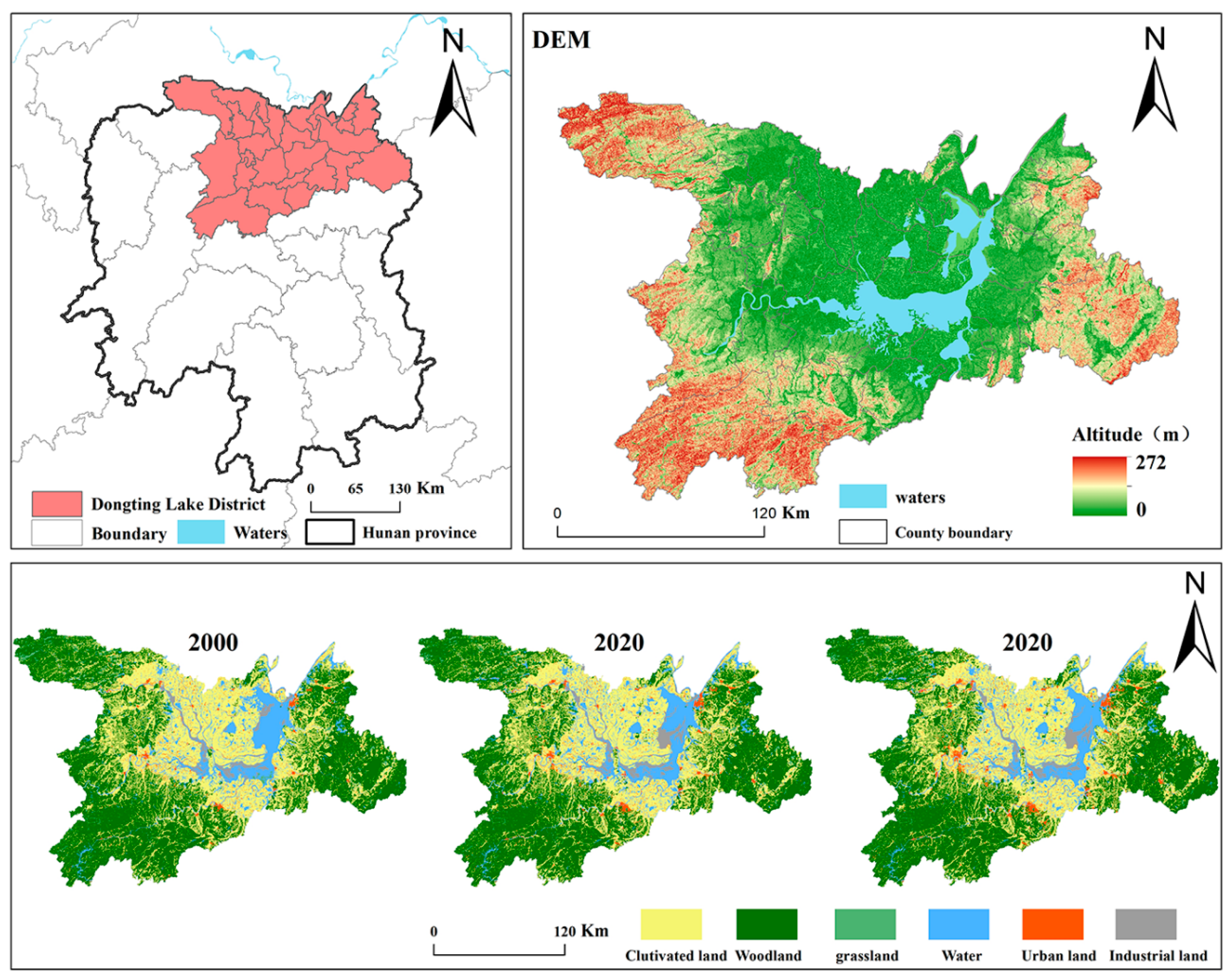
Figure 2.
Intensity of land use transition and motivation, 2000-2020.
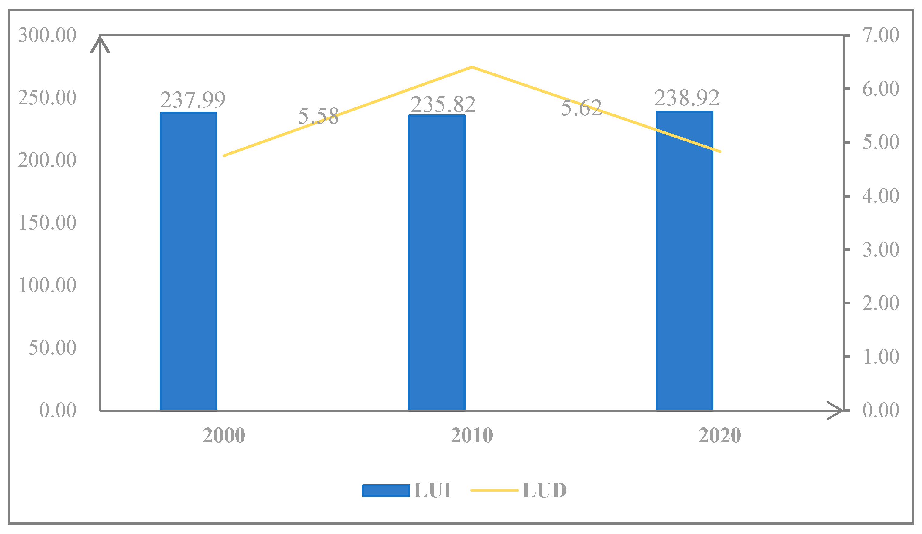
Figure 3.
Intensity of land use transition and dynamics of motivation.
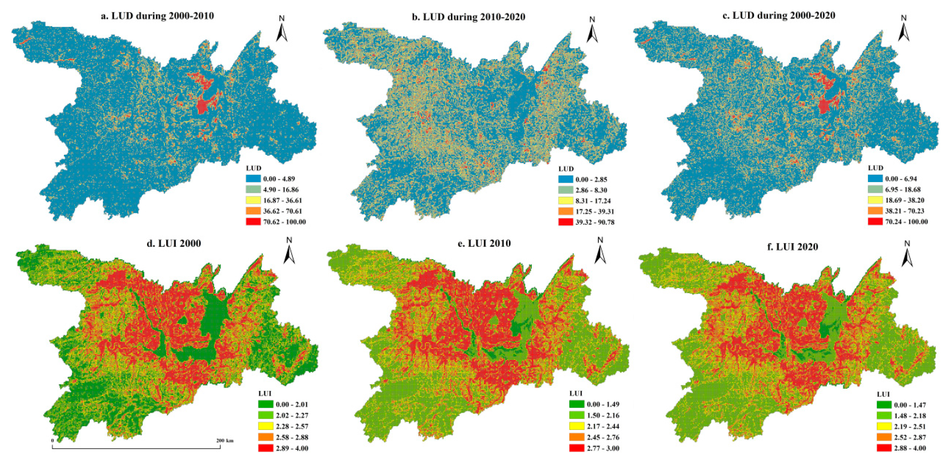
Figure 4.
Changes in various types of ecosystem services, 2000-2020.
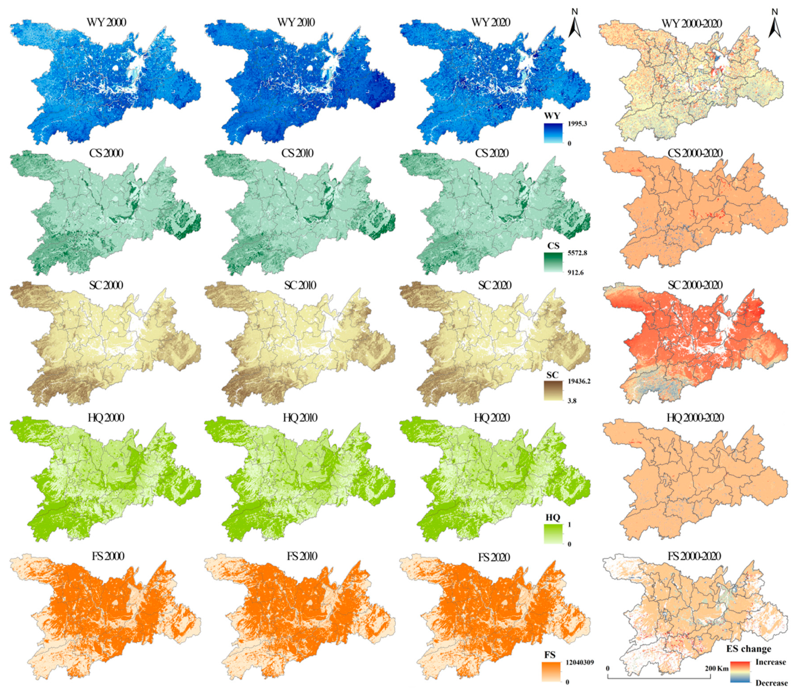
Figure 5.
Changes in the coefficients of the role of different influencing factors, 2000-2010.
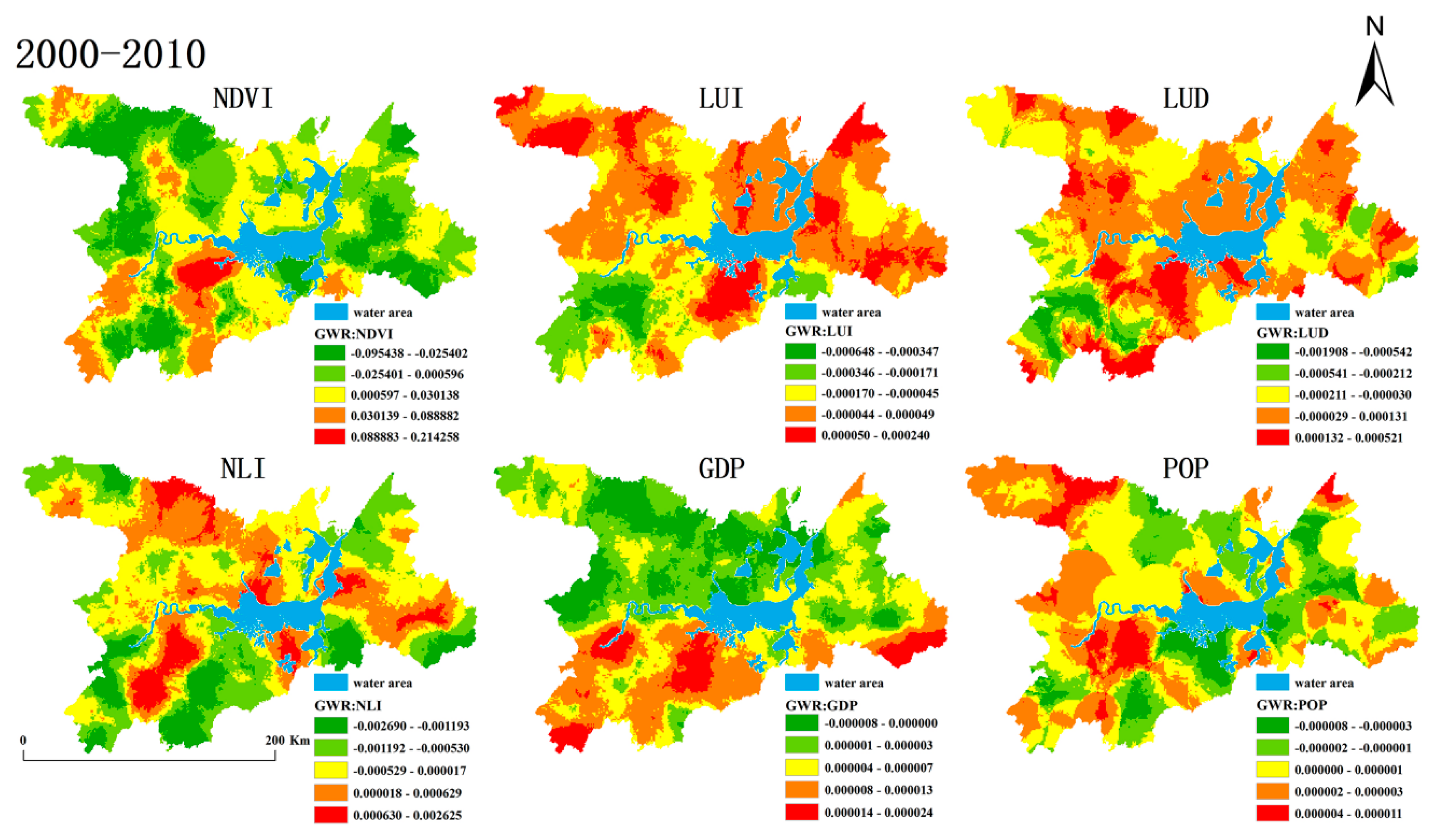
Figure 6.
Changes in the coefficients of the role of different influencing factors, 2010-2020.
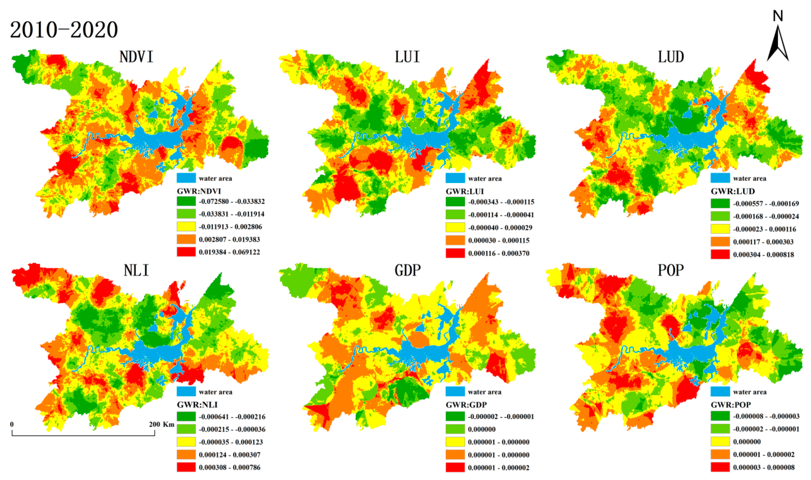

Table 1.
Data sources.
| Data name | Description of the data | Source of data |
|---|---|---|
| Nighttime Lighting Data | Currently, nighttime light data (NTL) is provided by the Defense Meteorological Satellite Program Operational Line Scan System (DMSP/OOLS) and the Defense Meteorological Satellite Program Operational Line Scan System (DMSP/OOLS) with a spatial resolution of 1 km × 1 km [22]. | In this paper, the Center for Resource and Environmental Sciences and Data (https://www.resdc.cn) of the Institute of Geographic Sciences and Resources, Chinese Academy of Sciences (IGSR, CAS) was selected |
| Population density | The population density datasets for 2000, 2010 and 2020 are available under the Creative Commons Attribution 4.0 International License at a spatial resolution of 1 km × 1 km. | Taken from ORNL LandScan Viewer - Oak Ridge National Laboratory (landscan.ornl.gov). |
| GDP intensity | Gross domestic product (GDP), as an essential and comprehensive statistical indicator in the accounting system, shows the rate of economic development of the new China. Also known as gross domestic product (GDP), it is an indicator that measures the results of productive activities in resident units. The spatial resolution of GDP data for 2000, 2010, and 2020 is 1 km x 1 km. | Retrieved from Center for Resource and Environmental Sciences and Data, Institute of Geographic Sciences and Resources, Chinese Academy of Sciences (https://www.resdc.cn) |
| Food supply | Cereals, sugar crops, oil crops, meat, milk and fruits were the major food types used in this study. | Sourced from China Statistical Yearbook (2001-2020) and China Rural Statistical Yearbook (2001-2020) , and data on caloric composition of different foods were obtained from U.S. agricultural databases and related studies [4]. |
| Habitat quality | Land use data were primarily used for the habitat quality calculations derived from the inVEST Habitat Quality Module. | Habitat quality related parameter settings are taken from existing literature [23]. |
| Carbon density data | Mainly used as a reference for carbon density data for various carbon pools | Data were mainly obtained from the literature [24,25,26]. |
| Water yield services data | Derivation of the inVEST water production module. | Precipitation data are from the annual spatial precipitation interpolation dataset of China since 2000 (http://www.resdc.cn/data.aspx?DATAID=229), potential evapotranspiration data are from World Climate (https://www.worldclim.org/data/worldclim21.html), watershed and sub-basin boundary data based on DEM’s Chinese watershed and river network extraction dataset (http://www.resdc.cn/DOI/doi.aspx?DOIid = 44). |
| Soil data | The soil data resolution is 1000 meters, and the terrain ASTER GDEM data resolution is 30m | National Cryosphere Desert Data Centre (https://www.ncdc.ac.cn); Geospatial Data Cloud (http:// www.gscloud.cn). |
Table 2.
Formulas and descriptions of ecosystem service calculations.
| ESs | Calculation formula | Description |
|---|---|---|
| Carbon sequestration (CS) | Where CS is the total sequestered carbon supply (t/ha), is above-ground biochar, is below-ground biochar, is organic carbon in soil and is dead organic carbon. These four carbon pools were obtained from the results of a literature review [26,27,28]. | |
| Water yield services (WY) | Here is the annual water yield in pixel x in land use type j; x and j in are the actual annual evapotranspiration in pixel x in land use type j, which was estimated based on the reference evapotranspiration data, land use data, and related parameter data. is the annual precipitation in pixel x, which was compiled using precipitation data from the study area. Parameter data for estimating water yield such as biophysical tables and tensor constants were obtained through literature review [23,33]. | |
| Food supply (FS) |
Food availability in a given area c can be calculated using the following formula: |
Here is the total food energy produced in the area (kJ), is the area occupied by food C in the area I in the land use type K (HM2) and is the supply per unit area of the corresponding food c. here for a given area is the yield of the different food types c (kg) and is the calorie content of the different foods (kJ/kg). |
| Habitat quality (HQ) |
Here the series is the habitat quality of the grid in the habitat type , is a semi-saturation constant, the suitability of the habitat for the habitat type and the series is the degree of disturbance of the habitat type on the grid such that the ‘s series= |
Here is the threat factor, is the number of image elements of the grid layer cells of the threat factor , is the total number of cells occupied by the threat factor, is the weight of the threat factor taking values in the range of [0,1]. is the value of the threat factor of the grid Y (0 or 1), ‘s is the degree of disturbance of the grid threat factor on the habitat grid, is the sensitivity of the habitat type to the threat factor , is the availability of the grid taking values in the range [0,1]. Degree of disturbance Here is the linear distance between grids and and is the maximum working distance of the threat factor [34]. |
| Soil conservation (SC) | where is the rainfall erosion rate, MJ∙mm/(ha∙hr∙yr); is the monthly precipitation (mm/month); and is the annual precipitation (mm/year).K is the erodibility of the soil using the Erosion Productivity Impact Calculator (EPIC) model [35] where SAN, SIL, CLA, and C stand for the proportions of organic matter, sand, silt, and clay in the soil, respectively. |
Table 3.
Changes in ecosystem services, 2000-2020.
| Types of ESs | 2000 | 2010 | 2020 |
|---|---|---|---|
| WY | 490.726 | 902.007 | 690.102 |
| CS | 2289.954 | 2255.008 | 2247.457 |
| SC | 1088.317 | 1822.635 | 929.607 |
| HQ | 0.711 | 0.698 | 0.695 |
| FS | 4740855.28 | 6024647.791 | 7036502.467 |
Note: The unit of WY is mm; the unit of CS is t/hm2; the unit of SC is t/ha2/ha2; the unit of FS is KJ.
Disclaimer/Publisher’s Note: The statements, opinions and data contained in all publications are solely those of the individual author(s) and contributor(s) and not of MDPI and/or the editor(s). MDPI and/or the editor(s) disclaim responsibility for any injury to people or property resulting from any ideas, methods, instructions or products referred to in the content. |
© 2024 by the authors. Licensee MDPI, Basel, Switzerland. This article is an open access article distributed under the terms and conditions of the Creative Commons Attribution (CC BY) license (https://creativecommons.org/licenses/by/4.0/).
Copyright: This open access article is published under a Creative Commons CC BY 4.0 license, which permit the free download, distribution, and reuse, provided that the author and preprint are cited in any reuse.


