Submitted:
17 April 2024
Posted:
18 April 2024
You are already at the latest version
Abstract
Climate change is increasing air temperatures and altering the precipitation and hydrological re-gime on a global scale. Challenges arise when assessing the impacts of climate change on the local scale for water resources management proposes, especially for low mountain headwater catch-ments that not only serve as important water towers for local communities, but also have distinct hydrological characteristics. Until now, no low flow or hydrological drought studies have been carried out on the Lauter River. This study is unique in that it compares the Lauter River, a transboundary Rhine tributary with a nearby station on the River Rhine just below its confluence at the French-German border. The Lauter catchment is a mostly natural, forested catchment, however, its water course has been influenced by past and present cultural activities. Climate change disturbances cascade through the hydrologic regime right down to the local scale. As we are expecting more low flow events, the decrease in water availability could cause conflicts be-tween different water user groups in the Lauter catchment. However, the choice of different methods for identifying low flow periods may cause confusion for local water resources manag-ers. Using flow rate time series of the Lauter River between 1956 and 2022 we compare for the first time three low flow identification methods: the variable threshold method (VT), the fixed threshold method (FT), and the Standardized Streamflow Index (SSI). Similar analyses are applied and compared to the adjacent Maxau station on the Rhine River for the same time period. This study aims at 1) interpreting the differences amongst the various low flow identification methods and 2) revealing the differences in low flow characteristics of the Lauter catchment compared to the Rhine River. It appears that the FT reacts faster to direct climate or anthropogenic impacts whereas VT is more sensitive to indirect factors such as decreasing subsurface flow which is typical for small headwater catchments, such as the Lauter where flow dynamics react faster to flow disturbances. Abnormally low flow during the early Spring in tributaries such as the Lauter can help predict low flow conditions of the Rhine River during the following half year and espe-cially for the summer. The results could facilitate Early Warning of hydrological droughts and drought management for water users in the Lauter catchment and further downstream along some of the Rhine.
Keywords:
Low flow
; Hydrological drought identification
; Low mountain catchment
1. Introduction
Climate change with rising temperature alters interannual behavior of key hydrological components, such as precipitation, evapotranspiration, and snowpack, hence fundamentally modifying the global water cycle. There have been many studies in Europe focusing on evaluating the impacts of future climate scenarios on water resources on a continental scale[1,2,3]. However, studies on smaller, low-mountain, forested catchments are scarcer[4]. In this study the Lauter catchment bordering France and Germany was chosen since it is a rural, sparsely populated catchment and pioneering example for transboundary water resources management under climate change and biodiversity protection within a new Interreg project, RiverDiv. Despite the uncertainties introduced by different downscaling methods and hydrological models from large-scale approaches, they all suggest a high hydrological vulnerability of the region surrounding the Lauter River catchment. Hagemann et al. compiled runoff generated from three global climate models (GCMs) regarding the A2 emissions scenario. Central, Eastern and Southern Europe will face significant decrease in water resources with more than 10% decrease for the period 2071-2100 based on 1971-2000[1]. Donnelly et al. further performed a sensitivity analysis on the hydrologic impacts of temperature increase and found out that the runoff signal was more sensitive to a 1.5 degrees mean global warming scenario than a temperature increase of 2 to 3 degrees[2]. Nevertheless, the hydrological regime changes not only according to the magnitude of the annual average temperature, but also according to seasonal temperature fluctuations , which influences the timing of the peak flow and frequency of drought events. Schneider et al. indicated that the European temperate oceanic zone will face higher precipitation in winter and lower in summer and will expect a shift in flow regime with higher runoff towards winter and lower flow in summer[3]. Challenges in Central Europe for water resources management are well summarized by Stagl et al. for three aspects, 1) changes of seasonality, 2) changes of evapotranspiration and soil moisture, and 3) changes of rain-snow distribution[5]. As we zoom into the Rhine basin, studies show similar predictions of changes in the flow regime. The Rhine River will be expecting a significant modification in runoff in the far future (2071-2100)[6] with a 42% decrease in summer flow and a 14% increase in winter flow[7]. Fluctuations in evapotranspiration and soil moisture will result in more “flash-drought” events in Rhineland Palatinate[8] characterized by rapid drought onset and severe desiccation thus placing local water resources management at higher risk, particularly in the agricultural sector.
River runoff is important for domestic water supply, agricultural irrigation, industrial usage, ecological services, navigation, and recreational uses. Being menaced by decreasing runoff in summer, water agencies need wise and accurate water resources planning strategies to secure the demand for each water use section. Hence, defining hydrological drought periods is a crucial step for setting up catchment-wide water resources management plans. Regarding different uses, there are generally four types of drought definition: meteorological drought, hydrological (including hydrogeological) drought, agricultural drought, and socio-economic drought. Many studies have been focusing on the linkage and propagation between these different drought types[9,10]. However, in a first step we only focus on low flow identification of the Lauter catchment in this study, as the stream runoff is the most direct factor effecting local water resources management. In a second step, we compare low flow events in the Lauter, a confluent of the Rhine with an adjacent station on the River Rhine at a larger scale.
Numerous low flow indices are used by hydrologists in determining low flow events. Defining drought events with a predefined threshold was first introduced by Yevjevich in 1967[11] and Zelenhasić et al. in 1987[12]. These studies defined the structure of the low flow hydrograph and its key components, which are drought duration, severity as cumulative flow deficit, and probability and recurrence analysis[11,12]. Recent studies have shown a paradigm shift by including anomalies into drought period identification, such as the variable threshold and the Standardized Streamflow Index (SSI)[13]. Yet different water use sectors have different practical definitions for drought. For instance, hydro-power stations require targeted water yield volumes with a fixed threshold, whereas ecologic services require the identification of seasonally abnormally low flow. Recent studies have also called for comprehensive comparison amongst different low flow indices[13]. Hence, the objective of this paper are: 1) to compare different threshold approaches (i.e., fixed threshold and variable threshold) and a statistical approach (i.e., SSI) for identifying drought events, 2) to assess and recommend the most appropriate approach for the highly dynamic local-scale Lauter River basin and for the adjacent downstream station on the Rhine River representing a regional scale river basin. Despite the Upper Rhine basin being much larger and more complex than the Lauter, we assume that droughts are large-scale, persevering phenomena that can be extracted and compared at different spatial scales.
This study is novel since it is the first time that a low flow analysis has been performed on the Lauter River catchment and furthermore the first time that it has been compared to the Rhine River. In addition, this is the first study that puts the extreme drought year 2022 into a long-term time perspective. We hope that this research can serve as an example for low flow analysis of small-scale stream catchments and provide a fundamental base for local water resources management.
2. Study Area
The Lauter River flows through the Upper Rhine valley[14] and is a confluence of the Rhine river. It takes its source from two headwater streams, the Wieslauter and the Salzbach which join to form the Wieslauter. It flows through the Palatinate Forest in Germany, continues as the Lauter on the French-German border and ultimately flows into the Rhine River. The highest altitude in the catchment is the Weissenberg at 609.3 m and the lowest point is 115 m at the confluence of the Lauter with the Rhine. The geology of the Upper Lauter (Wieslauter) catchment is dominated by Buntsandstein sandstones from the Trias and sedimentary layers of Zechstein from the Late Permian whilst the Lower Lauter is dominated by Pleistocene-Quaternary and alluvial sediments of the Rhine. The information was retrieved from the State office for Geology and Mining of Rheinland-Pfalz, https://mapclient.lgb-rlp.de//?app=lgb&view_id=4 (accessed on 10 January 2024). The Lauter catchment contains large groundwater reservoirs. From a geomorphological perspective it has highly incised low mountains with characteristic rock pinnacles and rock terraces and soils are mainly sandy. Forest dominates the catchment and is part of the Palatinate Forest which belongs to one of the largest, continuous forest areas in Mid-Europe. The climate is temperate, with annual average temperature of 10.7°C based on the Deutscher Wetterdienst climate data of the Bad Bergzabern station between 1950-2022. Mean annual total rainfall is 950-1050 mm of the Upper Lauter and 700-800 mm of the Lower Lauter between 1951-2020[15]. The catchment has a dense network of sources and streams and the average discharge of the Lauter at different discharge stations are presented in Table 1.
Even though the Lauter catchment is a sparsely populated natural, forested catchment, the Lauter River is highly influenced by past and present human activities especially by an ancient, semi-natural wood-rafting pond system. The northern part of the headwater area is designated as drinking water protection zone and the western part belongs to the Palatinate Forest-North Vosges Biosphere Reserve. Small urban areas are clustered along the river valley and tributaries and the main villages and towns from upstream to downstream are Hinterweidenthal, Dahn, Bundenthal, Wissembourg and Lauterbourg. Upstream urban area modifications to the natural hydrological regime include river channelization, bank stabilization, small hydro-stations, and surface water and groundwater extractions for drinking water and industrial uses. As the Lauter River exits the mountain area of the Palatinate Forest downstream of Wissembourg, the flatter downstream part is largely occupied by agricultural land. Natural water courses have been strongly modified over time for irrigation. Surface water and groundwater pumping for agricultural usages also alter the local natural hydrological regime. The catchment location and hydro-morphological characteristics are presented in Figure 1 and Table 2.
The Upper Rhine is influenced by a glacio-nival regime and has been highly modified during the 19th and 20th centuries, mainly by rectification and the introduction of sluices and hydro-electric dams which has profoundly changed its natural regime. However, the station Maxau analysed in this study only reflects the navigable part of the Rhine whose regime is no longer controlled by dams. Furthermore, its regime is not yet influenced by major tributaries since it is still upstream of the Moselle and Main.
This study uses streamflow data of the only two available discharge gauging stations on the Lauter River, the Bobenthal station and the Salmbacher Passage station in Germany. For the Rhine River, we use the discharge data from the Maxau station which is the closest station just downstream of the Lauter catchment with long-term monitoring results. The locations of the stations are showed in Figure 1. The Bobenthal station is located at the border of the Pfälzerwald, where the Lauter River drains from the mountains to the plain. The Salmbacher Passage station is located further downstream after the Lauter has passed through an intensively used agricultural region. Hence, the streamflow differences between these two stations could demonstrate both how anthropogenic factors and the geological setting can alter the hydrological regime, especially when considering different drought identification approaches. Data sources and time series duration are presented in Table 1. All the data used within this study are extracted from public open source.
3. Methodology
Here we present the methodology and the parameter and distribution functions we chose to apply in this study. The study period as presented in Table 1 is from 1956 to 2022.
3.1. Variable and Fixed Threshold Methods
The threshold approach is commonly employed for defining low flow periods in hydrological analyses. Common thresholds approaches include the daily threshold and monthly threshold[17]. Other than the fixed threshold which considers desired water yield required by water users, the variable threshold takes seasonality into account and reveals any abnormalities of the flow regime[18].
Gamma, Pearson Type III, Weibull, and Log-normal distribution are commonly used for hydrological parameter analyses[19]. We chose to use two-parameter Gamma distribution for this study as it has been proven to fit well with streamflow time series of the Rhine basin[20]. Since there were no zero values within the streamflow time series, we do not have to consider the zero-flow case. Hence, the gamma distribution function for each streamflow time series, denoted as and the corresponding cumulative probability are presented as below,
where and are the shape and scale parameters.
For perennial streams, the exceedance rate is normally set within the range of 75% to 90%[21]. In particular, the French Water Law from 1992 (La loi sur l'eau de 1992) defines the threshold “QMNA (annual minimum monthly flow)” for different return periods. The QMNA 5 which denotes the monthly averaged low flow value with a 5-year return period is widely used in the Rhin-Meuse basin (SDAGE 2022-2027, Rhin-Meuse)[22]. Hence, we employed an exceedance rate of 80% for both the variable and fixed threshold in this study. We then used a 30-day and a 3-month moving average to smooth the daily and monthly threshold correspondingly.
The challenge was to define the complete drought period in situations with several minor drought periods of mutual dependence or a significant extended drought period with several inferior, spiky flow disturbances. For this we employed the pooling criteria “inter-event time” and “inter-event ratio” for defining the drought events based on variable threshold methods by Zelenhasić and Salvai in 1987[12]. Figure 2 presents the pooling process. We tested out different pooling scenarios, and defined the pooling criteria combination of of and as the pooling criteria for this study. For detailed comparison, see the supplementary information.
Nevertheless, minor droughts could cause significant noise in the final result. In order to screen out the disturbance from minor droughts, we excluded drought events with flow deficit value of less than 0.5% of the maximum deficit value[23].
3.2. The Standardized Streamflow Index (SSI)
The Standardized Streamflow Index (SSI) identifies streamflow drought events with the same calculation steps as for meteorological drought events using the standardized Precipitation Index (SPI). SSI analyses streamflow series using a hydro-meteorological approach. This is the only parameter recommended by the WMO for streamflow drought analysis[24]. In recent years an increasing number of studies are using SSI to analyze catchment drought patterns[25,26,27]. Whereas hydrologists tend to study the streamflow character based on a finer spatial and temporal resolution, the meteorological approach using SSI prefers to interpret environment signals on a monthly or yearly scale. However, for catchments such as the Lauter catchment with a relatively small contributing area and high streamflow variations, there have been few studies investigating the ability of the SSI to recognize drought events.
Many researchers have been focusing on assessing the accuracy of SSI from a statistical approach[19, 28]. However, few studies compare the SSI with fixed or variable threshold methods for identifying drought events and their characteristics. As more and more researchers are integrating SSI into their streamflow analysis, especially for drought prediction with machine learning[26, 29], this paper will use the Lauter catchment to demonstrate the similarities and differences between SSI and FTM and VTM considering that they are all based on monthly time series analysis. The same analysis will be done for the Rhine close to its confluence downstream of the Lauter and compared to the Lauter.
We used the Standardized Drought Analysis Toolbox (SDAT) of Matlab to conduct the SSI analysis in this study. The toolbox can be accessed via https://www.mathworks.com/matlabcentral/fileexchange/51081-standardized-drought-analysis-toolbox-sdat (accessed on 17 August 2023)[30]. It calculates the SSI based on a non-parameter approach using empirical Gringorten plotting position other than fitting with parametric functions[28].
The empirical probability equation used in this study is as below[28],
where is the streamflow series ranking from low to high, and is the total number of observations and denotes the ranking order.
4. Results
The low flows identified by the three methods are compared in this section. The total events count, duration, and deficit volume patterns are presented for each approach.
4.1. Threshold Approaches
The streamflow series of the Bobenthal, Salmbacher Passage and Maxau station are studied using both variable and fixed threshold approaches. Total number and general characteristics of drought events identified by each analysis are shown in Table 4 and Table 5. Since monthly resolution thresholds analyze the deficit based on a monthly scale, the deficit volume presented below is calculated by multiplying the difference between the monthly averaged streamflow value and the threshold with the number of the days of the corresponding month in order to compare it with the daily resolution thresholds.
Both VTM and FTM identify fewer drought events than VTD and FTD respectively due to their coarse temporal resolution. Sutanto et al. also found that VTD identified almost double the amount of drought events compared to VTM in their pan-European streamflow analysis[17]. As shown in Table 4, VTM always defines the drought events with a longer duration and higher maximum deficit volume. Moreover, concerning the fixed threshold approaches in Table 5, FTM also identifies a longer average duration but lower maximum deficit volume. However, both variable and fixed thresholds have higher average deficit volumes for a monthly resolution compared to the daily resolution. Regarding the detection limit (i.e., minimum deficit volume), all methods were capable of detecting droughts with low deficits of similar scale.
Both the monthly threshold and variable threshold of each approach extended over similar time periods even though the number of identified drought events were different. The gap between the events number was mainly caused by the shorter droughts which could only be detected via a daily resolution. As for the hydrograph behavior, the peak deficit volume was always concomitant between daily and monthly resolution for each approach and the rising and falling limbs followed similar trends. Please see the supplementary document for further information.
4.2. The Standardized Streamflow Index (SSI)
There is no actual climate station available within the Lauter catchment. Here we present the average annual precipitation and temperature values provided by the Deutscher Wetterdienst of the Bad Bergzabern station which is closest to the three stations with long-term climate records. As shown in Figure 3, there are rising trends in both winter and summer temperatures.
The Standardized Streamflow Index of 1-month, 6-month and 12-month are calculated for each of the three stations. The percentage of each drought category for low flow identified by SSI-1, SSI-6, and SSI-12 of the study period are presented in Table 6. As the calculation time scale augmented from 1-month to 12-month, the Bobenthal and Salmbacher Passage stations on the Lauter River increasingly resembled the Maxau station on the Rhine River. All the stations revealed decreasing weighting for abnormal and moderate droughts and increasing weighting for extreme and exceptional droughts. We further plotted out the SSI results in Figure 4. Zalokar et al. suggested that an appropriate time scale should be chosen to better represent catchment drought characteristics[25]. We could not observe any significant percentage change (above 0.1%) in the extreme or exceptional drought class when increasing the accumulation period from 1 month to 12 months, neither for the Rhine River nor for the Lauter River. Hence, we decided to use SSI-12 which identified the drought severity more comprehensively with regard to the antecedent conditions for further comparisons with FTM and VTM.
It is noticeable that the Lauter River has a relatively higher percentage of 0.5% to 1.7% for the extreme class but around 1% less for the exceptional class compared with the Rhine. In Figure 4 we noticed that the difference occurred mainly within the time period from 1971 to 1978. The streamflow of the Lauter River was around 1 m3/s during this time period. We think this statistical bias is due to limitations in measuring capacity during very low flow under drought events of the last century.
The SSI-12 in Figure 4 recognized similar streamflow trends for the variable and fixed threshold methods. As for the time period 1950-1980, severe to exceptional droughts were observed between 1963-1964, 1971-1974, and the year 1976 for the Lauter River. The Rhine River showed seasonal fluctuations with the most significant drought period identified in the years 1954, 1960, 1963, and 1965. Nevertheless, the SSI-12 was relatively stable with no significant drought signals from 1981 to 2000, and a notable downward trend for each station since the beginning of this century.
5. Discussion
The identification of low flow by the variable threshold, fixed threshold and SSI methods are discussed according to the differences in approaches used and according to the variations caused by the characteristics of each station. The implications of the results with respect to past climate change and their current and future applicability and predictability are also discussed.
5.1. Differences amongst Drought Identification Methods
Low flow events observed at daily resolution were mostly clustered in three different time periods, 1950-1980, 1981-2000, and 2001 till now. During the first period, low flow events in the Lauter and Rhine were more severe and of much longer duration, followed by the second period with relatively fewer severe low flow events of lower frequency. Since the beginning of this millennium, low flow events seem to have become more erratic and scattered all over the year. Rapidly onsetting “flash droughts” are rarely long-lived since they are frequently interrupted by rather insignificant, spiky floods to form “drought-flood” cascading events. Climate change has thus introduced higher variations to streamflow both in small- scale catchments such as the Lauter and in large-scale catchments such as the Rhine. In their historical hydrological drought analysis of the Upper Rhine valley over the last 450 years until 2006 Pfister et al also obtained a clear increase in low flow values (7-day annual mean) after the 1980s[32].
As a daily indicator, the FTD systematically produced longer average duration and higher average flow deficit volumes than the VTD and extracted more accurate detection limits within our study area. It is noticeable that such a pattern is not universal. Study of snowmelt and rainfall driven catchments in both Canada and China appear to have both longer drought duration and higher severity when using VT than FT[9]. On the other hand, studies in America in minimally disturbed catchments report a longer duration with FT and higher deficit with VT[33]. We argue that the climate regime has a dominant influence on low flow behavior for each index. Therefore, we recommend that a thorough comparison among different low flow indices should be performed before giving recommendations for local water resources regulations.
We also noticed differences in the total events count and maximum deficit volume for FTD and VTD linked to the characteristics of each station. The variable threshold approach is more robust in detecting low flow signals for the Bobenthal station due to the buffering effect of the forest and sandstone geology of the upper Lauter catchment (Wieslauter) on low flow. As such, both the variable and fixed threshold approaches attain nearly the same maximum flow deficit volumes. However, at Salmbacher Passage the fixed threshold approach is a better indicator of water scarcity reflecting human water abstraction from the town of Wissembourg and the surrounding irrigated agricultural area. As for Bobenthal, the two threshold methods produce very similar maximum flow deficit volumes but Salmbacher Passagehad higher maximum flow deficit volumes identified by fixed threshold than variable threshold. Interestingly, low flow characteristics of the Rhine at Maxau are very comparable to Salmbacher Passage with similar high interannual low flow variability in terms of duration and severity and a similar gap between the two threshold approaches. Overall, Rhine low flows are relatively shorter and attain less severe relative deficit volumes than at Bobenthal over the entire study period. Caution should be taken when applying the fixed and variable threshold methods in smaller catchments such as the Lauter since they can produce very contrasting results even if the streamflow stations lie in geographic proximity and within the same climatic zone. It seems that human influences such as small dams with ponds and irrigation can significantly alter the natural hydrological regime thereby increasing streamflow variations and causing a gap between the fixed and variable threshold results.
For both rivers, most low flow events begin in early winter around December (Figure 5). It is interesting to note that the months in which low flows most commonly develop depend on station location and threshold approach. Although low flow starting dates are particularly discordant for the two stations on the Lauter there is strong concordance between the Upper Lauter (Wieslauter) and the Rhine station. For the Bobenthal station, low flows mostly begin in December. However, there is a larger spread in low flow starting dates over the whole Winter and Spring season produced by the VT (i.e., from December to April). Salmbacher Passage shows a similar seasonal spread of low flow initiation identified by VT, whilst the seasonally less sensitive FT produces opposite staring dates in the summer months around July. This is because FT applies only one single value for the whole year, making it difficult for FT to predict an early low flow signal during a drought winter with a precipitation deficit. At the Rhine station, low flow events also predominantly begin in December. But as for the Lauter, there is a larger monthly spread from the variable threshold approach. The month that is least prone to low flow begin in the Lauter is June at Bobenthal and April at Salmacher Passage respectively, and July in the Rhine.
It also seems that low flow signals are more scattered since the beginning of this millennium due to more abrupt disturbances created by “flash-droughts” and “drought-flood” cascading events thus qualifying VT over FT (Figure 6). An increase in annual low flow events, as shown in the downward trends of the SSI-12 index corresponds well with the deficit volumes identified by the threshold approaches for the Lauter as well as the Rhine in Figure 6. However, as SSI-12 calculates the index based on the cumulative streamflow of the previous 12 months, SSI-12 always reaches the lowest minimum value after the threshold method reaches the highest deficit volume peak. Its resolution is therefore far too coarse for water management purposes. Application of the SSI-12 index as an only indicator would be inappropriate for designing water resources management plans as it incorrectly identifies and predicts the beginning and end of low flows . However, SSI-12 is efficient in categorizing the drought severity situation by including antecedent conditions which is not possible when using the threshold approach. Hence, we suggest combining the SSI-12 index with the threshold identification methods for low flow diagnosis as threshold methods are very sensitive to streamflow anomalies and the SSI-12 index delivers a comprehensive drought severity classification. For major drought events in the last century, it is noticeable that VTM can predict significant low flow events during the previous winter/spring half year from low flow signals before the onset of major streamflow deficit. This was the case for the drought periods of 1963-1964, 1971-1972, and 1975-1976 at the Bobenthal station, and 1971-1974 at the Salmbacher Passage station. However, there were no early low flow signs from VTM at the Maxau station during this time period mostly because the Rhine River is less dynamic and has less streamflow variations than the Lauter River at this location.
Furthermore, we took an intensive look at the 1976 drought year in Figure 6. The drought period started first at the Salmbacher Passage station in September 1975, followed by the Bobenthal station in December 1975 and was only picked up in January 1976 at the Maxau station on the Rhine River which has a much larger and more complex, glaciated catchment. Studies have revealed that the 1976 drought was caused by high temperatures and amplified by excessive evapotranspiration which lead to decreased subsurface storage[34, 35]. The Salmbacher Passage station, located downstream of the Bobenthal station on the Rhine plain, picked up the low flow signal from the fixed threshold approach three months earlier. This is because Salmbacher Passage is more vulnerable to droughts and low flows as a result of anthropogenic influences such as water abstraction from irrigation and household consumption. In contrast, Bobenthal benefits from the drought-buffering role of its undulating, forested catchment and the sponge effect of its sandstone geology, possibly enhanced by the water retention role of its multiple valley stream ponds. The mountain headwater characteristics thus gave it a lead into the winter before the onset of low flow.
We also argue that the fixed threshold reacts faster to direct climatic or artificial impacts such as water abstraction whereas the variable threshold reacts more strongly to more complex signals issued from indirect factors such as decreasing subsurface flow. This is typical for small headwater catchments that are more sensitive to flow disturbances. Other research based on European catchments agrees that the VT approach is more flexible when dealing with anomalies in low flow conditions[36, 37]. However, in our two rivers the earlier warning ability of VT over FT was only true for identification low flow clusters between 1958 and 1980. In the third period (after 2000) VT substantially lost its predictive ability over FT (Figure 6). Being more sensitive to flow abnormalities, VT reacts earlier than FT to low flows beginning in the winter/spring half year, such as in March 2004 at both the Bobenthal station and Salmbacher Passage station. However, FT starts around the same time as the VT for low flows in the summer season, such as August 2007, July 2008, July 2015 and June 2020 at Bobenthal station, and August 2005, July 2009 and June 2015 at Salmbacher Passage station. In contrast, the, Maxau station did not follow this pattern, due to much more complex antecedent conditions and influences of a large alpine catchment as well as significant artificial influences by sluices and dams that dominate over the natural regime. For the Maxau station, drought events defined by FT were constantly interrupted by high peak flow events in contrast to the VT approach. Therefore, even though the FT is useful for navigation purposes in terms of accurately differentiating high and low flows, the VT is more appropriate for accurately defining the beginning and end of an integral drought period in view of ecosystem services and water resources management.
5.2. Differences between the Lauter Tributary and the Rhine River
We analyzed several significant drought events to understand the differences between the Lauter and Rhine River. Despite the Rhine catchment being a much larger catchment than the Lauter, this study shows that the network of low flow monitoring stations on the Lauter are strong early indicators for the Maxau station on the Rhine. This can be very helpful for drought prediction and water management in the Rhine. Our hydrological analyses of all the main tributaries bordering the Rhine in Alsace (France) and Baden Württemberg (Germany) show that low flow events have extremely similar behavior over the past 20 years. This is because droughts are large-scale, long-lasting phenomena that have a direct influence on the streams, whether draining the Vosges or Black Forest[38].
For the drought period of 1962-1964, which was caused by an extremely cold winter and prolonged snow storage[32], drought events were also diagnosed at the Maxau station between September 1962 and February 1963, Decembre 1963 and February 1964, and the following summer between June 1964 and October 1964. The Salmbacher Passage station on the Lauter River showed similar behavior whereas the upstream Bobenthal station only generated low flows signals from February 1963 onwards but lasting over the whole year of 1964. Low flow increased as indicated by the SSI-12 index of the Bobenthal station from March 1963 onwards, the Salmbacher Passage from August 1962 onwards, and Maxau station from July 1962 onwards. It appears that the hydrological regime at the Maxau station on the Rhine River was much more dominated by the snow and glacier melt from the Alps. Hence, the Lauter catchment with a relatively low elevation has less predictive capacity over the adjacent Rhine River for this drought type.
The situation is different for the 1970s, where prolonged dry spells[39] resulted in exceptional droughts in the Rhine and Lauter Rivers, but only extreme droughts at Bobenthal. The Bobenthal and Salmbacher Passage stations started revealing flow deficit starting in March 1971 and at Maxau starting in January 1971. However, during the following years until the next extreme drought year in 1976, the two stations on the Lauter River were constantly exposed to streamflow deficit in contrast to the Rhine River station that only generated some separate drought signals. For the 1976 drought year in the Lauter the Salmbacher Passage station started experiencing flow deficit from August 1975 onwards followed by the Bobenthal station in December 1975, whereas the Rhine River station at Maxau only reacted at the beginning of 1976. Moreover, the low flow event terminated in September 1976 for Bobenthal but only three months later in December 1976 for Salmbacher and the Rhine respectively. This was at a time when urban development was not yet too intensive upstream of Bobenthal and irrigation was not yet introduced around Salmbacher Passage. It appears that small tributaries such as the Lauter River generate more reliable drought period indications than the Rhine River itself. The recovery or not of Rhine tributaries such as the Lauter from low flow impacts can provide early warning for drought termination or potential drought beginning for the Rhine River.
Brunner et al. concluded that the rainfall-deficit drought type dominates more drought events over the lower elevation Alps region since 1994[40]. The Bobenthal station, representing the most upstream flow station in the headwater catchment, showed the most significant decreasing trend in SSI-12 and increasing drought periods since the beginning of this century. As mentioned above, drought periods are now perturbated more frequently by high flow peaks caused by short floods thereby interrupting the continuity of low flow events. Recently the Maxau station has developed a tendency towards separate low flow signals during dry years, usually one in the early spring and another one later in the same year, such as in April 2017 and June-July 2017, April 2021 and October-November 2021, March 2022 and May-September 2022.
The 2018 hydrological drought had particularly disastrous impacts on the Rhine, bringing navigation to a temporarily halt. According to our analyses and in contrast to the previous period from 1980 to 2000, low flows started nearly simultaneously in July at all three stations following a Spring and summer rainfall deficit[41]. Again, the Rhine at Maxau imitated the Lauter at Bobenthal well but experienced a less severe relative low flow deficit. Regarding the year 2022, it is interesting to note that the characteristics of the 2022 low flow event were different to the 1976 event. The Rhine River flow deficit between April and September 2022 was amplified by the lack in recharge during the 2021/2022 winter but started later and finished much earlier than in 1976. The Bobenthal station already signaled low flow as early as April 2021 which indicates inadequate winter water storage in the headwater catchment, primarily due to a lack of snow. Similarly, the Rhine at Maxau signaled low flow in April 2021. No data is available for Salmbacher passage for 2022.
It is noteworthy that both the available data of Bobenthal station and Salmbach Passage station (which only had data available until the end of 2020) identified gaps within the low flow events of the Maxau station. Hence, observing the tributaries streamflow behavior during early Spring helps predicting the drought conditions of the Rhine River for the following half year. This has major potential for hydrological drought risk assessment and for implementing different water level saving policies at the beginning of the year.
6. Conclusions
In this study, we studied the flow rate time series of the Lauter River from 1956 until mid-2023 and compared it with the closest station on the Rhine River. We employed the fixed threshold method, variable threshold method, and standardized streamflow index to identify low flows for two streamflow stations on the Lauter River, which are the Bobenthal station and the Salmbacher Passage station and one on the Rhine River, the Maxau station, in order to evaluate the differences between each approach and their applicability to both a small headwater catchment and a large-scale catchment. Our findings showed that, for threshold approaches, monthly resolution (VTM, FTM) analysis always generates less low flows with higher average duration than the daily resolution (VTD, FTD). In spite of these differences, they were all capable of identifying low flows for each station with good consistency. VTD showed the ability of predicting the low flow event by revealing low flow signals in the previous winter/spring half year before both the VTM and VTD started to detect major deficit volumes in the streamflow. However, such patterns no longer prevailed since the year 2000. The FTD did not dispose over such significant predictive ability over FTM. Since more “flash droughts” and “flood-drought cascading events” are disturbing the flow rate time series due to climate change, VT is more robust than FT in defining the beginning and the end of low flow periods. Furthermore, we found that the FT reacts faster to direct climate or artificial impacts such as irrigation or dams whereas VT reacts to indirect factors such as decreasing subsurface flow and higher evapotranspiration, especially for small headwater catchments with higher flow dynamic reactions to flow disturbances. The standardized streamflow and threshold approaches were consistent and an increase in low flow events was evident in both in the Lauter and Rhine River since 2000. We suggest that local water resources managers should combine the 12-monthly SSI index with the threshold approaches for better low flow identification and severity evaluation. It is noteworthy that, as rainfall-deficit droughts are starting to dominate more low flow events in this century, we find that abnormally low flow during the early spring time in Rhine tributaries such as the Lauter can help predict low flow conditions of the Rhine River during the following summer and autumn. Water managers will need to adapt to more frequent, seasonally much earlier but shorter low flow events on both the Rhine and tributaries such as the Lauter as a result of lacking precipitation storage (mainly snow) and higher temperatures. They will also need to adjust to the dwindling seasonal buffering role of low mountain water towers for droughts and low flows since the beginning of this millennium. Despite differences in the scale of catchments, situations can occur (such as in 2018) where the beginning of low flow events is no longer temporally offset in the Lauter tributary and Rhine but instead starts simultaneously. This means a lack of several months of buffering flow from headwater catchments during low flows further downstream. Hence, we suggest that further studies could focus on integrating more streamflow time series analysis from low mountain Rhine tributaries into seasonal low flow early warning systems for the Upper Rhine Valley.
Supplementary Materials
The following supporting information can be downloaded at the website of this paper posted on Preprints.org, Figure S1: Sensitivity analysis of relative mean duration for different pooling criteria combinations of between 5 to 30 days and between 0 to 0.3; Figure S2: Drought identification comparisons between Variable Daily Threshold (VTD) and Variable Monthly Threshold VTM for low flows in Lauter and Rhine Rivers; Figure S3: Drought identification comparisons between the Fixed Daily Threshold (FTD) and Fixed Monthly Threshold (FTM) for low flows in the Lauter and Rhine River.
Author Contributions
Data obtaining, Xiaowei Liu and Carmen de Jong; methodology and data analysis, Xiaowei Liu; writing—original draft preparation, Xiaowei Liu; writing—review and editing, Carmen de Jong and Xiaowei Liu.
Funding
This research was funded by European Regional Development Fund (ERDF), Interreg Upper Rhine Project RiverDiv (A3-3).
Data Availability Statement
All data used in the article are open source data.
Acknowledgments
I acknowledge the funding support from European Regional Development Fund (ERDF), Interreg Upper Rhine for the project RiverDiv which embeds this research paper and my PhD position.
Conflicts of Interest
The authors declare no conflict of interest.
References
- Hagemann, S.; Chen, C.; Clark, D. B.; Folwell, S.; Gosling, S. N.; Haddeland, I.; Hanasaki, N.; Heinke, J.; Ludwig, F.; Voss, F.; et al. Climate Change Impact on Available Water Resources Obtained Using Multiple Global Climate and Hydrology Models. Earth Syst. Dyn., 2013, 4, 129–144. [Google Scholar] [CrossRef]
- Donnelly, C.; Greuell, W.; Andersson, J.; Gerten, D.; Pisacane, G.; Roudier, P.; Ludwig, F. Impacts of Climate Change on European Hydrology at 1.5, 2 and 3 Degrees Mean Global Warming above Preindustrial Level. Clim. Change, 2017, 143(1–2), 13–26. [Google Scholar] [CrossRef]
- Schneider, C.; Laizé, C. L. R.; Acreman, M. C.; Flörke, M. How Will Climate Change Modify River Flow Regimes in Europe? Hydrol. Earth Syst. Sci., 2013, 17, 325–339. [Google Scholar] [CrossRef]
- Forest Hydrology: Processes, Management and Assessment; Amatya, D. M., Williams, T. M., Bren, L., De Jong, C., Eds.; CAB International: Oxfordshire Boston, MA, 2016. [Google Scholar]
- Managing Protected Areas in Central and Eastern Europe Under Climate Change; Rannow, S., Neubert, M., Eds.; Advances in Global Change Research; Springer Netherlands: Dordrecht, 2014; Vol. 58. [CrossRef]
- Lobanova, A.; Liersch, S.; Nunes, J. P.; Didovets, I.; Stagl, J.; Huang, S.; Koch, H.; Rivas López, M. D. R.; Maule, C. F.; Hattermann, F.; et al. Hydrological Impacts of Moderate and High-End Climate Change across European River Basins. J. Hydrol. Reg. Stud., 2018, 18, 15–30. [Google Scholar] [CrossRef]
- Graham, L. P.; Hagemann, S.; Jaun, S.; Beniston, M. On Interpreting Hydrological Change from Regional Climate Models. Clim. Change, 2007, 81, 97–122. [Google Scholar] [CrossRef]
- Wang, M.; Menzel, L.; Jiang, S.; Ren, L.; Xu, C.-Y.; Cui, H. Evaluation of Flash Drought under the Impact of Heat Wave Events in Southwestern Germany. Sci. Total Environ., 2023, 904, 166815. [Google Scholar] [CrossRef] [PubMed]
- Wu, J.; Yao, H.; Wang, G. Propagation Characteristics of Hydrological Drought Based on Variable and Fixed Threshold Methods in Snowmelt and Rainfall Driven Catchments. Water, 2022, 14 (20), 3219. [Google Scholar] [CrossRef]
- Behrang Manesh, M.; Khosravi, H.; Heydari Alamdarloo, E.; Saadi Alekasir, M.; Gholami, A.; Singh, V. P. Linkage of Agricultural Drought with Meteorological Drought in Different Climates of Iran. Theor. Appl. Climatol., 2019, 138(1–2), 1025–1033. [Google Scholar] [CrossRef]
- An Objective Approach to Definitions and Investigations of Continental Hydrologic Droughts. J. Hydrol., 1969, 7(3), 353. [CrossRef]
- Zelenhasić, E.; Salvai, A. A Method of Streamflow Drought Analysis. Water Resour. Res., 1987, 23, 156–168. [Google Scholar] [CrossRef]
- Stahl, K.; Vidal, J.-P.; Hannaford, J.; Tijdeman, E.; Laaha, G.; Gauster, T.; Tallaksen, L. M. The Challenges of Hydrological Drought Definition, Quantification and Communication: An Interdisciplinary Perspective. Proc. Int. Assoc. Hydrol. Sci., 2020, 383, 291–295. [Google Scholar] [CrossRef]
- Tockner, K.; Uehlinger, U.; Robinson, C. T. Rivers of Europe; Academic Press: Amsterdam London, 2009. [Google Scholar]
- Baumeister, C.; Kampf, J.; Petry, H.; Schykowski, M.; Stein, J. Wasserversorgungsplan Rheinland-Pfalz 2022, 2022.
- European Environment Agency; European Environment Agency. CORINE Land Cover 2018 (Raster 100 m), Europe, 6-Yearly - Version 2020_20u1, May 2020, 2019. [CrossRef]
- Sutanto, S. J.; Van Lanen, H. A. J. Streamflow Drought: Implication of Drought Definitions and Its Application for Drought Forecasting. Hydrol. Earth Syst. Sci., 2021, 25, 3991–4023. [Google Scholar] [CrossRef]
- Van Loon, A. F.; Laaha, G. Hydrological Drought Severity Explained by Climate and Catchment Characteristics. J. Hydrol., 2015, 526, 3–14. [Google Scholar] [CrossRef]
- Vicente-Serrano, S. M.; López-Moreno, J. I.; Beguería, S.; Lorenzo-Lacruz, J.; Azorin-Molina, C.; Morán-Tejeda, E. Accurate Computation of a Streamflow Drought Index. J. Hydrol. Eng., 2012, 17, 318–332. [Google Scholar] [CrossRef]
- Ehmele, F.; Kautz, L.-A.; Feldmann, H.; He, Y.; Kadlec, M.; Kelemen, F. D.; Lentink, H. S.; Ludwig, P.; Manful, D.; Pinto, J. G. Adaptation and Application of the Large LAERTES-EU Regional Climate Model Ensemble for Modeling Hydrological Extremes: A Pilot Study for the Rhine Basin. Nat. Hazards Earth Syst. Sci., 2022, 22, 677–692. [Google Scholar] [CrossRef]
- Ahmadi, B.; Moradkhani, H. Revisiting Hydrological Drought Propagation and Recovery Considering Water Quantity and Quality. Hydrol. Process., 2019, 33, 1492–1505. [Google Scholar] [CrossRef]
- Directive cadre européenne sur l’eau SDAGE 2022-2027 des districts « Rhin » et « Meuse », Tome 2, 2022.
- Tallaksen, L. M.; Madsen, H.; Clausen, B. On the Definition and Modelling of Streamflow Drought Duration and Deficit Volume. Hydrol. Sci. J., 1997, 42, 15–33. [Google Scholar] [CrossRef]
- Tijdeman, E.; Stahl, K.; Tallaksen, L. M. Drought Characteristics Derived Based on the Standardized Streamflow Index: A Large Sample Comparison for Parametric and Nonparametric Methods. Water Resour. Res., 2020, 56(10), e2019WR026315. [Google Scholar] [CrossRef]
- Telesca, L.; Lovallo, M.; Lopez-Moreno, I.; Vicente-Serrano, S. Investigation of Scaling Properties in Monthly Streamflow and Standardized Streamflow Index (SSI) Time Series in the Ebro Basin (Spain). Phys. Stat. Mech. Its Appl., 2012, 391, 1662–1678. [Google Scholar] [CrossRef]
- Modarres, R. Streamflow Drought Time Series Forecasting. Stoch. Environ. Res. Risk Assess., 2007, 21, 223–233. [Google Scholar] [CrossRef]
- Botai, C. M.; Botai, J. O.; De Wit, J. P.; Ncongwane, K. P.; Murambadoro, M.; Barasa, P. M.; Adeola, A. M. Hydrological Drought Assessment Based on the Standardized Streamflow Index: A Case Study of the Three Cape Provinces of South Africa. Water, 2021, 13(24), 3498. [Google Scholar] [CrossRef]
- Farahmand, A.; AghaKouchak, A. A Generalized Framework for Deriving Nonparametric Standardized Drought Indicators. Adv. Water Resour., 2015, 76, 140–145. [Google Scholar] [CrossRef]
- Shamshirband, S.; Hashemi, S.; Salimi, H.; Samadianfard, S.; Asadi, E.; Shadkani, S.; Kargar, K.; Mosavi, A.; Nabipour, N.; Chau, K.-W. Predicting Standardized Streamflow Index for Hydrological Drought Using Machine Learning Models. Eng. Appl. Comput. Fluid Mech., 2020, 14, 339–350. [Google Scholar] [CrossRef]
- HRL. Standardized Drought Analysis Toolbox (SDAT), 2023.
- Hao, Z.; AghaKouchak, A.; Nakhjiri, N.; Farahmand, A. Global Integrated Drought Monitoring and Prediction System. Sci. Data, 2014, 1(1), 140001. [Google Scholar] [CrossRef] [PubMed]
- Pfister, C.; Weingartner, R.; Luterbacher, J. Hydrological Winter Droughts over the Last 450 Years in the Upper Rhine Basin: A Methodological Approach. Hydrol. Sci. J., 2006, 51, 966–985. [Google Scholar] [CrossRef]
- Hammond, J. C.; Simeone, C.; Hecht, J. S.; Hodgkins, G. A.; Lombard, M.; McCabe, G.; Wolock, D.; Wieczorek, M.; Olson, C.; Caldwell, T. Going Beyond Low Flows: Streamflow Drought Deficit and Duration Illuminate Distinct Spatiotemporal Drought Patterns and Trends in the U.S. During the Last Century. Water Resour. Res., 2022, 58(9), e2022WR031930. [Google Scholar] [CrossRef]
- Briffa, K. R.; Van Der Schrier, G.; Jones, P. D. Wet and Dry Summers in Europe since 1750: Evidence of Increasing Drought: WET AND DRY SUMMERS IN EUROPE SINCE 1750. Int. J. Climatol., 2009, 29, 1894–1905. [Google Scholar] [CrossRef]
- Teuling, A. J.; Van Loon, A. F.; Seneviratne, S. I.; Lehner, I.; Aubinet, M.; Heinesch, B.; Bernhofer, C.; Grünwald, T.; Prasse, H.; Spank, U. Evapotranspiration Amplifies European Summer Drought: EVAPOTRANSPIRATION AND SUMMER DROUGHTS DROUGHTS. Geophys. Res. Lett., 2013, 40, 2071–2075. [Google Scholar] [CrossRef]
- Sarailidis, G.; Vasiliades, L.; Loukas, A. Analysis of Streamflow Droughts Using Fixed and Variable Thresholds. Hydrol. Process., 2019, 33, 414–431. [Google Scholar] [CrossRef]
- Beyene, B. S.; Van Loon, A. F.; Van Lanen, H. A. J.; Torfs, P. J. J. F. Investigation of Variable Threshold Level Approaches for Hydrological Drought Identification; preprint; Hydrometeorology/Mathematical applications, 2014. [CrossRef]
- De Jong, C. Quelle vulnérabilité du Fossé rhénan aux changements climatiques et anthropiques ? Exemples d’analyses climatologiques, hydrologiques et hydrogéologiques, 2022.
- Khadr, M.; Morgenschweis, G.; Schlenkhoff, A. Analysis of Meteorological Drought in the Ruhr Basin by Using the Standardized Precipitation Index. 2009, 3 (9).
- Brunner, M. I.; Götte, J.; Schlemper, C.; Van Loon, A. F. Hydrological Drought Generation Processes and Severity Are Changing in the Alps. Geophys. Res. Lett., 2023, 50 (2), e2022GL101776. [Google Scholar] [CrossRef]
- Benedict, I.; Van Heerwaarden, C. C.; Van Der Linden, E. C.; Weerts, A. H.; Hazeleger, W. Anomalous Moisture Sources of the Rhine Basin during the Extremely Dry Summers of 2003 and 2018. Weather Clim. Extrem., 2021, 31, 100302. [Google Scholar] [CrossRef]
Figure 1.
Map of the study area with landuse map obtained from CORINE Land Cover inventory[16] and the streamflow stations.
Figure 1.
Map of the study area with landuse map obtained from CORINE Land Cover inventory[16] and the streamflow stations.
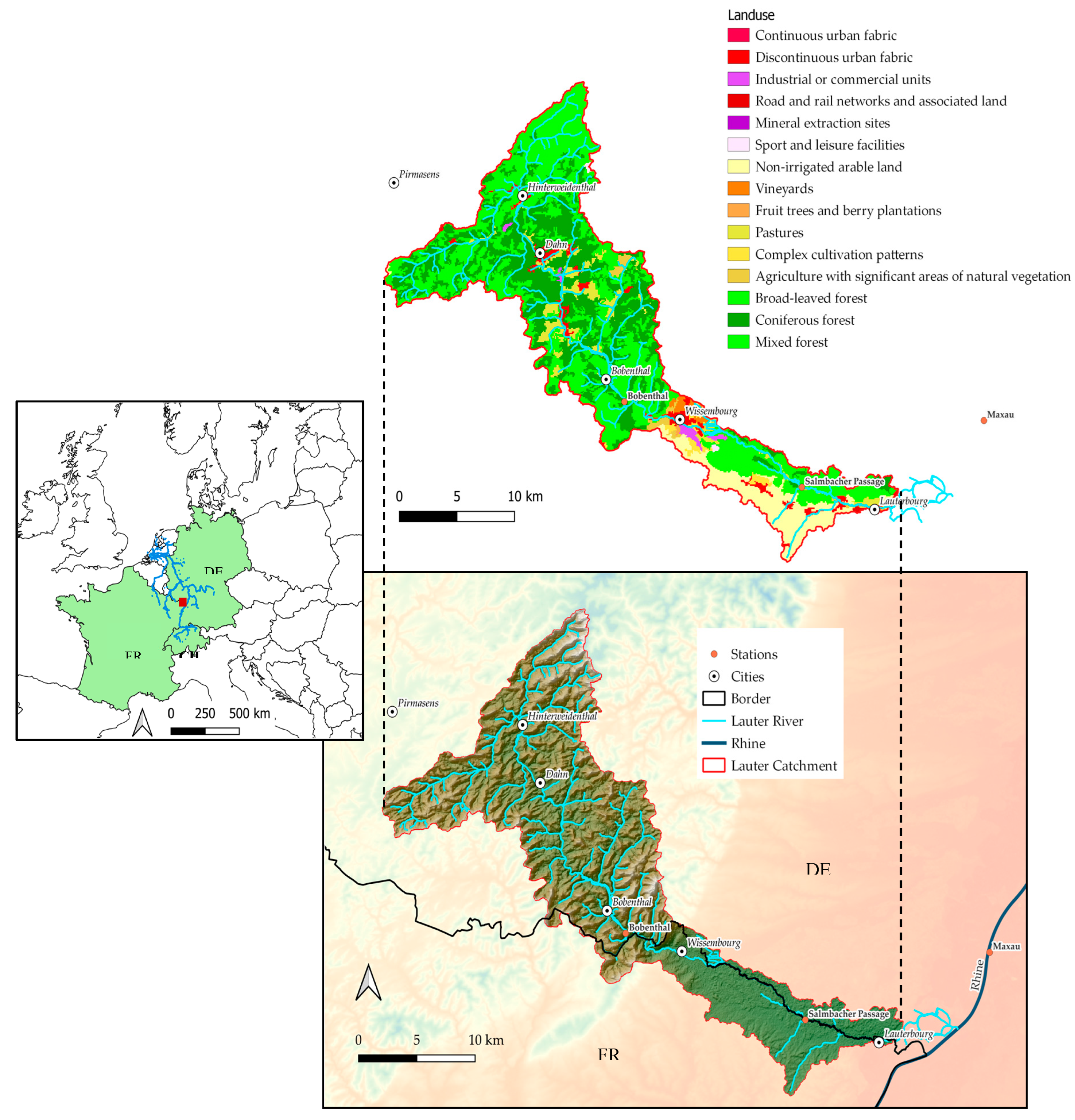
Figure 2.
Schematic demonstration of the pooling criteria, where , , . The inter-event ratio is defined as, .
Figure 2.
Schematic demonstration of the pooling criteria, where , , . The inter-event ratio is defined as, .
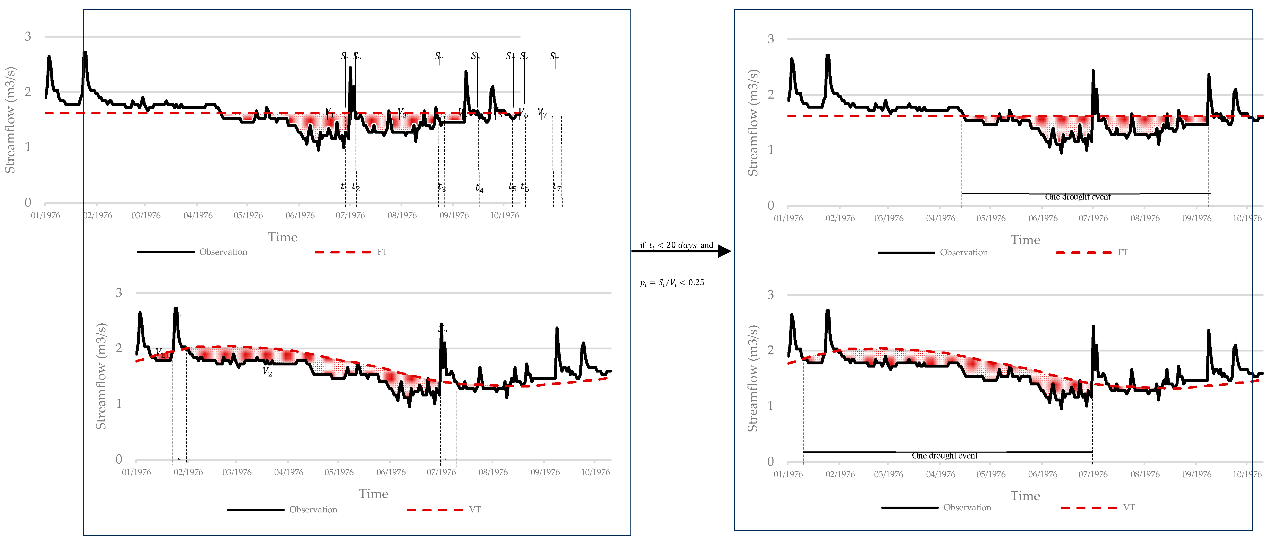
Figure 3.
Precipitation and temperature time series of the Bad Bergzabern station between 1950 and 2022 with seasons separated from the preceding year October to May as the winter/spring half year and April to September as summer/fall half year, the dotted lines showed the temperature trends.
Figure 3.
Precipitation and temperature time series of the Bad Bergzabern station between 1950 and 2022 with seasons separated from the preceding year October to May as the winter/spring half year and April to September as summer/fall half year, the dotted lines showed the temperature trends.
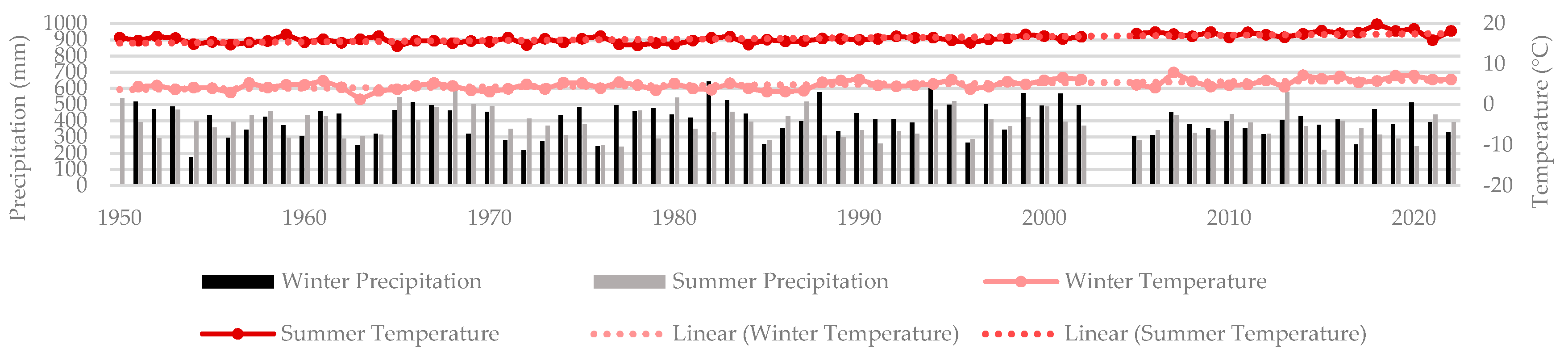
Figure 4.
The Standardized Streamflow Index (SSI) between 1950 and 2022 for the Bobenthal and Salmbacher Stations on the Lauter and Maxau on the Rhine River.
Figure 4.
The Standardized Streamflow Index (SSI) between 1950 and 2022 for the Bobenthal and Salmbacher Stations on the Lauter and Maxau on the Rhine River.
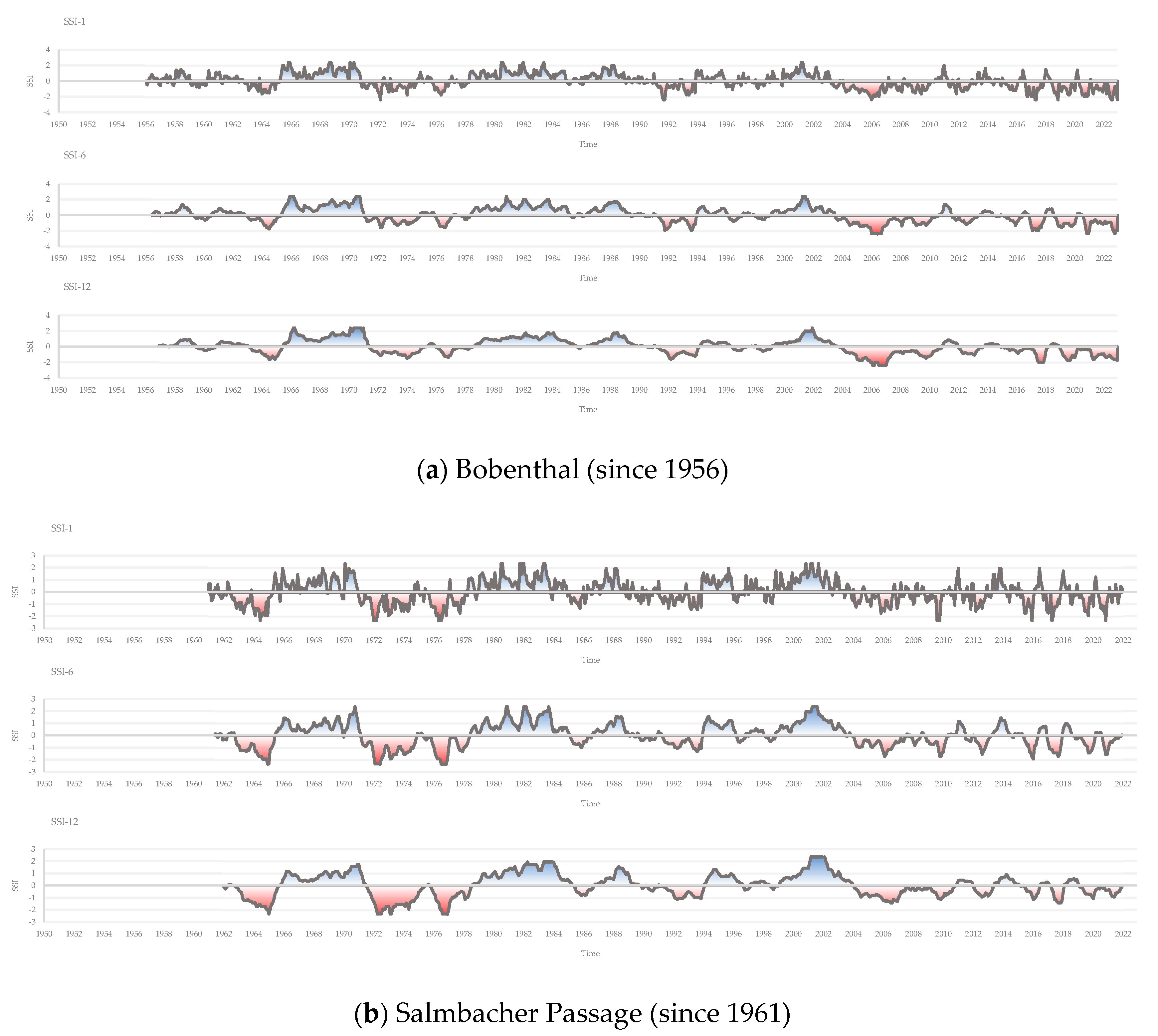
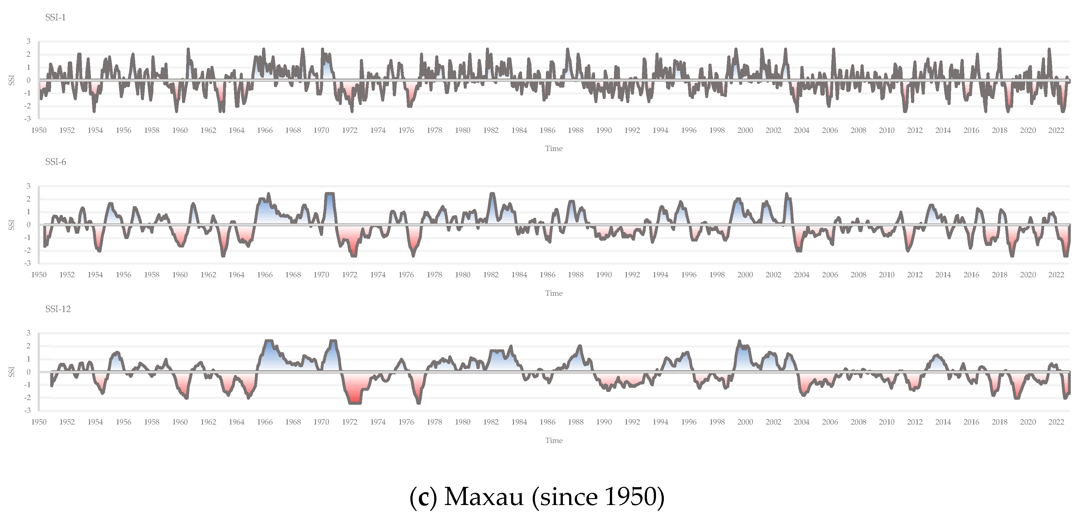
Figure 5.
Radar maps with the total count of low flows starting dates for each event for each specific month in the Lauter and Rhine Rivers based on the Variable Daily Threshold (VTD) and Fixed Daily Threshold (FTD) over the time period 1950 to 2022.
Figure 5.
Radar maps with the total count of low flows starting dates for each event for each specific month in the Lauter and Rhine Rivers based on the Variable Daily Threshold (VTD) and Fixed Daily Threshold (FTD) over the time period 1950 to 2022.
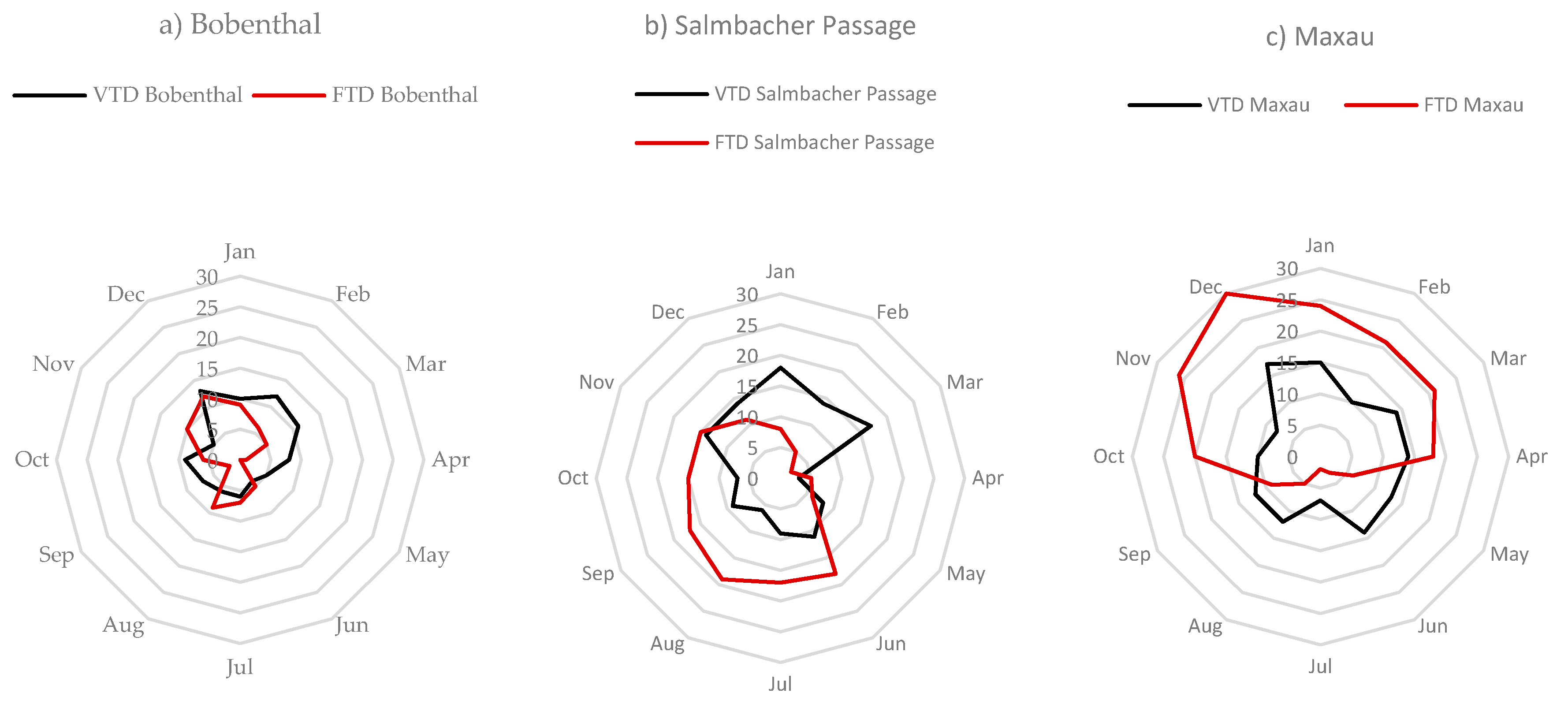
Figure 6.
Comparison between Variable Monthly Threshold (VTM), Fixed Threshold Method (FTM), and Standardized Streamflow Index (SSI)-12 for each station along the Lauter and Rhine River between 1950 and 2022.
Figure 6.
Comparison between Variable Monthly Threshold (VTM), Fixed Threshold Method (FTM), and Standardized Streamflow Index (SSI)-12 for each station along the Lauter and Rhine River between 1950 and 2022.
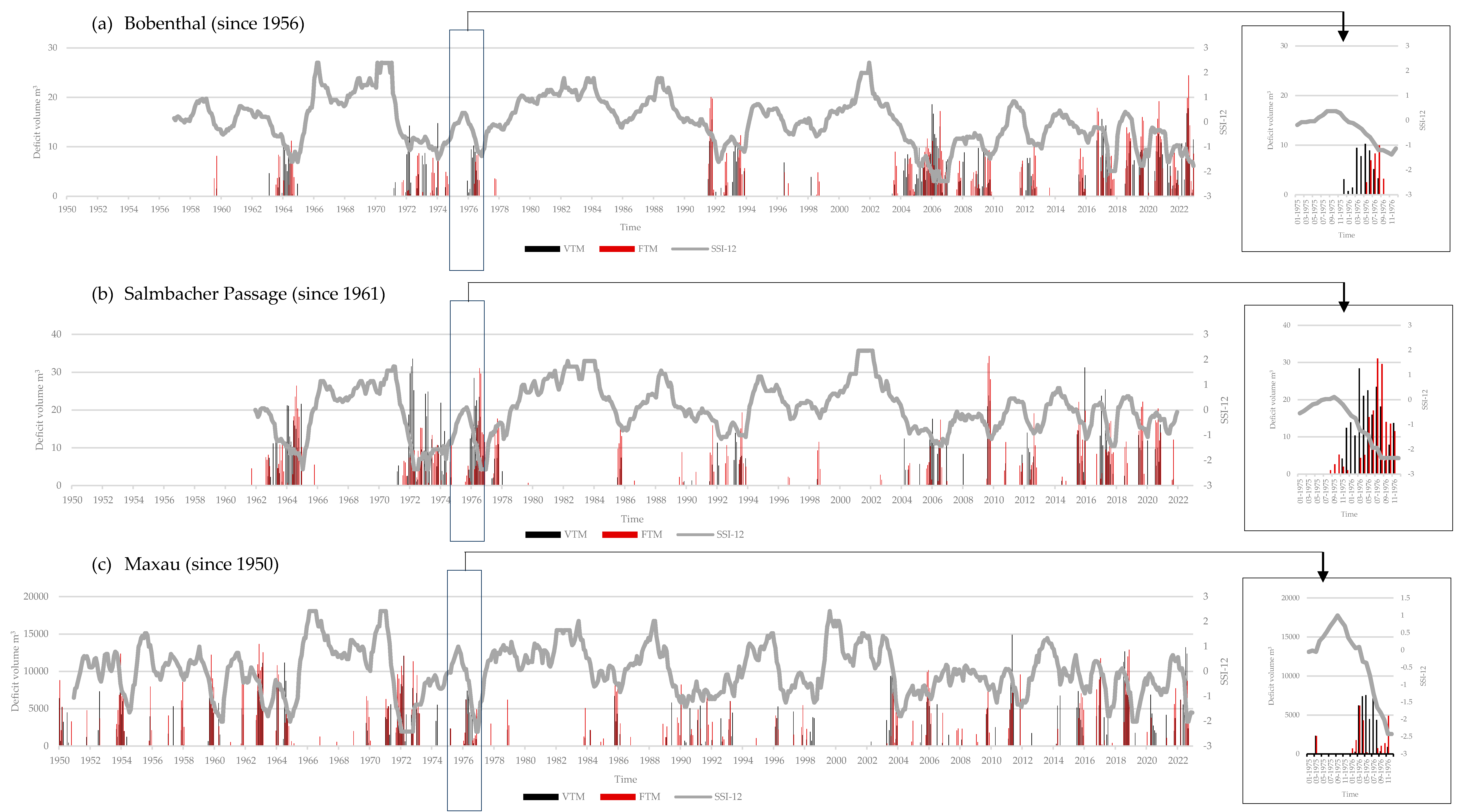

Table 1.
Summary of the basic characteristics of each station.
| Station | Altitude (m) | Catchment Area (km2) | Distance to Rhine (km) | Study period | Average discharge (m3/s) |
|---|---|---|---|---|---|
| Bobenthal (Lauter) | 173 | 253 | 37.2 | 1956/01/01-2023/06/15 | 2.31 |
| Salmbacher Passage (Lauter) | 127 | 345 | 15.6 | 1961/01/01-2021/12/31 | 3.27 |
| Maxau (Rhine) | 98 | 50196 | - | 1950/01/01-2022/12/31 | 1250.98 |
Table 2.
Characteristics of the Lauter catchment.
| Parameter | Unit | Value |
|---|---|---|
| Area | (km2) | 375.8 |
| Elevation | (m) | 285 (107-609.3) |
| Average slope | (%) | 11.8 |
| Length of the mainstream | (km) | 74.6 |
| Slope of the mainstream | (%) | 0.25 |
| Geomorphology | (-) | Sandy |
Table 3.
Categories of drought events based on SSI values.
| SSI | -0.50 to -0.79 | -0.80 to -1.29 | -1.30 to -1.59 | -1.60 to -1.99 | -2.0 or less |
| Category | Abnormally dry | Moderate drought | Severe drought | Extreme drought | Exceptional drought |
Table 4.
Summary of the VTD and VTM results.
| Station | Total events (counts) | Average duration | Max deficit (m3) | Min deficit (m3) | Avg deficit (m3) | |
|---|---|---|---|---|---|---|
| Bobenthal (Lauter) | VTD | 96 | 56.2 d | 131.73 | 0.66 | 9.81 |
| VTM | 47 | 3.8 m | 170.07 | 0.88 | 23.97 | |
| Salmbacher Passage (Lauter) | VTD | 130 | 35.8 d | 110.59 | 0.56 | 8.67 |
| VTM | 53 | 2.7 m | 195.77 | 0.98 | 28.76 | |
| Maxau (Rhine) | VTD | 146 | 35.7 d | 41429.96 | 220.68 | 2866.19 |
| VTM | 75 | 2.4 m | 49563.14 | 416.35 | 10467.23 | |
Table 5.
Summary of the FTD and FTM results.
| Station | Total events (counts) | Average duration | Max deficit (m3) | Min deficit (m3) | Avg deficit (m3) | |
|---|---|---|---|---|---|---|
| Bobenthal (Lauter) | FTD | 72 | 84.1 d | 131.26 | 0.70 | 15.20 |
| FTM | 43 | 3.8 m | 80.46 | 0.69 | 24.83 | |
| Salmbacher Passage (Lauter) | FTD | 138 | 43.0 d | 142.97 | 0.73 | 12.54 |
| FTM | 49 | 3.2 m | 141.74 | 0.72 | 29.90 | |
| Maxau (Rhine) | FTD | 185 | 45.1 d | 65880.90 | 339.23 | 7255.28 |
| FTM | 76 | 2.3 m | 61978.08 | 337.16 | 10893.43 | |
Table 6.
The percentage of each drought category for low flow based on the Standardized Streamflow Index (SSI) analysis in The Lauter and Rhine.
Table 6.
The percentage of each drought category for low flow based on the Standardized Streamflow Index (SSI) analysis in The Lauter and Rhine.
| Station | Abnormal | Moderate | Severe | Extreme | Exceptional | |
|---|---|---|---|---|---|---|
| Bobenthal (Lauter) | SSI-1 | 10.4% | 11.1% | 3.7% | 4.4% | 1.5% |
| SSI-6 | 10.4% | 11.8% | 3.1% | 4.5% | 1.5% | |
| SSI-12 | 9.9% | 12.0% | 3.0% | 4.5% | 1.5% | |
| Salmbacher Passage (Lauter) | SSI-1 | 9.8% | 11.5% | 4.9% | 3.3% | 1.6% |
| SSI-6 | 9.2% | 11.6% | 5.0% | 3.3% | 1.7% | |
| SSI-12 | 8.5% | 11.7% | 5.0% | 3.3% | 1.7% | |
| Maxau (Rhine) | SSI-1 | 11.0% | 11.0% | 4.1% | 2.7% | 2.7% |
| SSI-6 | 10.4% | 11.0% | 4.1% | 2.8% | 2.8% | |
| SSI-12 | 9.8% | 11.1% | 4.2% | 2.8% | 2.8% | |
Disclaimer/Publisher’s Note: The statements, opinions and data contained in all publications are solely those of the individual author(s) and contributor(s) and not of MDPI and/or the editor(s). MDPI and/or the editor(s) disclaim responsibility for any injury to people or property resulting from any ideas, methods, instructions or products referred to in the content. |
© 2024 by the authors. Licensee MDPI, Basel, Switzerland. This article is an open access article distributed under the terms and conditions of the Creative Commons Attribution (CC BY) license (http://creativecommons.org/licenses/by/4.0/).
Copyright: This open access article is published under a Creative Commons CC BY 4.0 license, which permit the free download, distribution, and reuse, provided that the author and preprint are cited in any reuse.


