

Submitted:
17 April 2024
Posted:
18 April 2024
You are already at the latest version
Abstract
The necessity for precise and current data concerning the dynamics of land cover change in Indonesia is crucial for efforts to reduce natural vegetation cover due to agricultural expansion. The functionality of monitoring systems that incorporate Terra-MODIS is currently compromised by the limited availability of data for the immediate future. This study seeks to assess the potential of VIIRS satellite imagery in developing an early warning system for monitoring vegetation cover change in Indonesia. The Normalized Differential Open Area Index (NDOAI) computed from the 8-day’ VIIRS data was employed to detect changes in vegetation cover based on pixel-by-pixel subtraction in the NDOAI data time series. Evaluating the pixel-level accuracy of change detection is complicated due to the fact that we evaluate a change map at a coarser resolution than the Landsat-based reference map. The results revealed that increasing the threshold percentage is associated with improved accuracy. In change detection, there is often a trade-off between accuracy and sensitivity. A threshold that is too low may result in false positives, while a threshold that is too high may lead to missed changes. This study demonstrates that when a threshold value of less than 20% is applied, Landsat can identify vegetation cover changes at an earlier stage. Conversely, when a threshold value greater than 20% is employed, VIIRS will detect the change 4.5 days earlier than Landsat. Additionally, VIIRS is capable of detecting changes 25.4 days and 54.8 days faster than Landsat, respectively, when using thresholds of 40% and 75%.
Keywords:
change detection
; temporal vegetation dynamics
; open area index
; multi temporal VIIRS
1. Introduction
Tropical forests worldwide have experienced recurrent disturbances over the past few decades, which have adversely impacted biodiversity, hydrology, livelihoods, and the global carbon cycle [1,2]. These disturbances are primarily caused by unsustainable forest exploitation, expansion of agricultural lands, illegal logging, and forest fires, which alter the structure, composition, and function of forest ecosystems [3]. Some international initiatives have been launched to restore and conserve forest ecosystems, including the Reducing Emissions from Deforestation and Degradation/REDD+ program [4], the Global Restoration Initiative [5], and the Bonn Challenge [6].
According to the results of COP 16 (paragraph 71 of decision 1/CP.16), National Forest Monitoring System (NFMS) is a crucial component of REDD+ implementation as it provides information on the status and trends of forest resources, land use, and greenhouse gas emissions and removals related to forests. This information enables the measurement, reporting, and verification (MRV) of REDD+ activities and their results, which is essential for accessing results-based payments and ensuring environmental integrity [7]. A comprehensive and dependable system for monitoring forests is esential to offer precise, prompt, and trustworthy information about changes in forest cover to decision-makers. This data can be utilized to prioritize regions for examination and enforcement, and to execute policies and measures to prevent, minimize, or restore forest disturbances [8,9,10].
The importance of NFMS emphasizes the need to develop an early warning system that can effectively address various forest disturbances, including complete deforestation, partial degradation, and the broader loss of vegetation cover, which are collectively referred to as devegetation [11]. It is crucial to acknowledge that devegetation monitoring is part of a broader initiative to preserve and maintain natural resources in a sustainable manner, as well as to mitigate the impacts of environmental degradation [12].
Advances in remote sensing technology enable land scientists to monitor rapid on-going land cover change with high temporal resolution satellite data [13]. The monitoring of land cover and its seasonal changes continuously in space and time allows a characterization of the vegetation dynamics, and consequently it should be possible to consider the rapid vegetation cover change [14]. In previous studies, the characterization of vegetation dynamics has often been performed using vegetation index values, and the temporal dynamics of these values have been used to detect changes in forest cover and its distribution [15,16,17,18,19].
The application of Moderate Resolution Imaging Spectroradiometer (MODIS) satellite data with high temporal resolution has been utilized effectively for real-time forest monitoring in various regions, such as the Brazilian Amazon through the DETER system [20], the State of Mato Grosso’s Sistema de Alerta de Desmatamento (SAD) [21], and the FORest Monitoring for Action (FORMA) initiative which provides twice-monthly deforestation alerting system for the humid tropical regions across Asia, Africa, and Latin America [22]. The research carried out by [23] revealed that MODIS data possesses the capacity to deliver consistent information about monthly land cover changes in Indonesia, by examining the patterns of vegetation index.
The development of an early warning system for vegetation cover changes, which utilized Terra-MODIS with a resolution of 500x500 meters, has resulted in the ability to provide information on vegetation changes every 8 days [24]. However, the use of this change detection method in Indonesia’s territory is limited by the spatial resolution of the data, particularly in areas such as Java island, where transient land cover changes may result in a feature size that is less than the minimum detectable extent or complex land cover patterns that affect the threshold value [25]. Despite its limitations in detecting vegetation changes within an area of ±25 ha, the system remains a valuable tool for monitoring vegetation changes in Indonesia due to its ability to provide timely information.
The utilization of MODIS data in the future is likely to be limited to sensors that are more than 24 years old, which is four times their original six-year design life. The Visible Infrared Imaging Radiometer Suite (VIIRS) sensor, which was launched on the Suomi NPP satellite in 2011, was designed to continue the legacy of MODIS for land observation science [26]. VIIRS data are available at a spatial resolution of 375 m in five spectral bands, and a range of VIIRS data products have been released, including a 500 meter surface reflectance product that uses the same grid system as the 500 meter MODIS product. Although MODIS records data at a higher resolution of 250 meters in the Red and NIR bands, one significant improvement of the VIIRS sensor over the MODIS sensor is its design to aggregate data from multiple detectors at lower angles of view and delete data from higher angles of view [27].
Given the anticipated operational use of satellite data for monitoring changes in vegetation cover, which has previously been carried out using MODIS data, it is imperative to conduct research on the potential performance of VIIRS data in the alert system application for monitoring operational changes in vegetation cover on a regional scale. This study aimed to evaluate a vegetation cover change algorithm based on VIIRS data toward, with the goal of functioning as an early warning system to prevent forest disturbances in Indonesia.
2. Materials and Methods
2.1. Satellite Data
A total of 10 Hierarchical Data Format (HDF) tiles of VIIRS data are employed to encompass all areas within Indonesia (Figure 1a). The data was obtained from NASA’s Land Processes Distributed Active Archive Center (LP DAAC) and the USGS Earth Resources Observation and Science (EROS) Center through the website https://e4ftl01.cr.usgs.gov/VIIRS/. In addition to VIIRS data, this study used a combination of specific datasets related to water masking, a list of HDF files for Indonesian regions, and a list of Indonesia 5x5 degree tiles. These datasets were utilized to automatically execute the change detection module, following the process design outlined in the Supplementary Material (Appendix A). The output image is divided into 5x5 degree tiles, as shown in Figure 1b.
The VIIRS Surface Reflectance product, also referred to as VNP09H1, provides an estimation of land surface reflectance derived from data collected by the Suomi National Polar-orbiting Partnership (Suomi NPP) VIIRS sensor. It includes information from three imagery bands (I1, I2, I3), which closely correspond to bands 1 (Red), 2 (Near-Infrared/NIR), and 6 (Shortwave Infrared/SWIR) of the MOD09A1 MODIS product [28,29]. These data are typically available at a resolution of 500 meters, which are derived through resampling the native 375m VIIRS resolution in the L2 input product. The VNP09H1 product is archived as 8-day composite product, comprising the best possible observation for each pixel during an 8-day period, based on high observation coverage, low sensor angle, the absence of clouds or cloud shadow and aerosol loading [28].
The utilization of mathematical combinations of spectral bands from remote sensing data serves to highlight particular features or characteristics of the Earth’s surface, including vegetation, water, and other objects [30]. Both SWIR and NIR bands are commonly used in remote sensing to detect changes in vegetation cover, but they serve slightly different purposes and have varying performance characteristics. NIR is sensitive to changes in vegetation biomass and leaf area index (LAI), making it useful for assessing overall vegetation health and density, while SWIR is valuable for detecting changes in vegetation moisture content and stress.
This study utilized NIR and SWIR to establish the Normalize Differential Open Area Index (NDOAI), which is designed to detect the change in vegetation cover. The mathematical formula for the NDOAI index is provided below:
where ρSWIR and ρNIR are reflectance shortwave infrared (SWIR) and near-infrared (NIR).
There are several indices leverage the unique spectral properties of NIR and SWIR bands such as Normalized Burn Ratio (NBR) to higlights changes in vegetation cover and moisture content after fire events [31] and Normalized Difference Water Index (NDWI) to detect the presence of water bodies and monitor changes in water content within vegetation as it is sensitive to changes in water absortion properties [32,33]. Using both NIR and SWIR bands allows for a complete comprehension of the vegetation dynamics as well as their modifications in an ecosystem [34].
2.2. Image Data Filtering in Temporal Domain
The VIIRS time series images quickly provide extensive data on vegetation cover changes, serving as an early warning system. However, these time-series datasets inevitably face disruptions caused by clouds, atmospheric changes, and aerosol scattering [35]. This interference introduces noise, degrading data quality and creating uncertainty in temporal sequences. This makes it challenging to analyze temporal image sequences due to significant variations in the time series data. Therefore, the initial step in processing data involves addressing these residual noises in the use of VIIRS time series datasets.
To tackle disturbances, we use VIIRS quality assurance data, specifically the cloud mask product, to eliminate cloudy pixels from VIIRS surface reflectance. Additionally, we employ linear interpolation to estimate values obscured by clouds. Furthermore, to enhance clarity in the time series VIIRS data, we composite VIIRS surface reflectance over a 8-day period to obtain a higher percentage of clear-sky data.
For the NDOAI image data, we employed two filtering techniques. Initially, we utilized linear interpolation to estimate missing values caused by cloud cover, a method that has been widely adopted for filling gaps in VIIRS products, similar to the approach used by [36] for MODIS datasets. Furthermore, we applied a median moving window over three images of the time series to smooth and decrease discontinuities and sharp spikes in the VIIRS data. This approach was previously employed by [37] for the MODIS dataset. Both of filtering approach is illustrated by Figure 2. Applying these filters allows for a clearer definition of the temporal vegetation pattern, which then serves as fundamental information for a near-real-time detection system for vegetation cover changes.
2.3. Vegetation Cover Change Detection
This study identified alterations in vegetation cover by employing an image differencing technique, which involves subtracting pixel values from NDOAI time-series data on a pixel-by-pixel basis, with the analysis conducted within a moving window every 8 days. The difference of NDOAI value denoted as △NDOAI, which is obtained as follows:
where year t-1 is 1 year series of NDOAI from the previous periode and 8-days of year t is 8-days NDOAI from current year.
△NDOAI = NDOAIyear t-1 – NDOAI8-days of year
The method used for change detection is a straightforward algorithm developed by [23] that has been modified to use an 8-day data period instead of the previous 1-month period. This method compares the differences between the vegetation index data from the previous year (year t-1) and the subsequent 8-day NDOAI values from the current year using a moving window for consecutive analysis (as shown in Figure 3). This approach involves systematically analyzing every new VIIRS data available and has the potential to be operationalized every 8 days to quickly identify vegetation changes across Indonesia.
To identify vegetation cover changes, a specific empirical threshold of -100 for ΔNDOAI was implemented to characterize changes in vegetation cover. This threshold was derived from prior research conducted by [25], which involved the examination of high-resolution imagery and field observations.
Figure 4 provides a visual representation of the shift in the NDOAI value pattern from the datasets of the previous year to the subsequent 8-day data, which is employed to track changes in vegetation cover. Any difference value of NDOAI greater than the specified threshold will be considered a vegetation cover change, while values below the threshold do not indicate a change in vegetation cover.
2.4. Accuracy Assessment
2.4.1. Sampling Design for Accuracy Test
A primary concern of the change detection approach is to assess vegetation cover disturbances detected at the pixel or sub-pixel level of VIIRS. In order to evaluate the VIIRS-based vegetation cover changes, we utilized Landsat data with a 30 m spatial resolution. Moreover, to ensure the accuracy of the change detection results in various ecosystems, we referred to more detailed image data, such as SPOT 6/7 and Pleiades satellite data, at several selected sites.
Evaluating the level of accuracy at the pixel level for detecting changes is a complex undertaking in this study, as it involves assessing a change map at a lower resolution than the reference map based on Landsat data. Binary vegetation change maps usually have two clear categories: change and no-change, and the same applies to the subsequent accuracy analysis. However, there is a proportion of vegetation disturbance for each VIIRS swath pixel. If no disturbance has occurred within the footprint of a VIIRS observation, it is evident that the observation will be labeled as no-change. Conversely, if 100% of the VIIRS footprint has changed, it will be labeled as vegetation change. Nevertheless, for cases in between, it is somewhat arbitrary to choose a single threshold to separate the two classes.
The evaluation of the real-time detection system’s performance was based on a 15.156 reference grid comprised of 100 points per grid. Our objective is to accurately identify areas of vegetation disturbance, with a smaller percentage being ideal. To achieve this, we defined the level of vegetation disturbance using various disturbance proportions, such as >70%, >40%, >30%, >20%, and <5% of a VIIRS pixel size (see Figure 5). For instance, a disturbance proportion of >40% indicates that at least 40% of the VIIRS pixel size is disturbed according to the reference map. In this case, VIIRS observations with a proportion greater than 20% disturbance are classified as “vegetation change”, while observations with less than 5% disturbance are categorized as “no-change”. Observations with a disturbance proportion between 5% and 20% are excluded, as they cannot be clearly labeled as either vegetation change or no-change.
Number of sample for accuracy test with regard to the percentage of landsat-based open areas is shown in Figure 6. The figure illustrates a decrease in the amount of data utilized for accuracy assessment, accompanied by an increase in the open area within a grid size of 500 m x 500 m.
Accuracy accessment were performed at 500 m x 500 m resolution to determine how the spatial resolution influenced the ability of VIIRS to detect changes, and to quantify the minimum size of disturbed patches that we could reliably detect. Even though the optimal threshold may vary with viewing geometry and spatial resolution, only one threshold was applied to detect vegetation disturbance for simplicity.
Moreover, Landsat typically has a 16-day revisit cycle, meaning it captures images of the same location every 16 days. Harmonized periods between VIIRS and Landsat were required to assess the temporal accuracy of the system. We converted the VIIRS datasets to a 16-day interval, aiming to align the temporal resolution of the VIIRS data with the Landsat data.
2.4.2. Evaluating Model Performance
In change detection, it is often more critical to ensure that all actual changes are detected (minimizing omission error). Omission errors can lead to a failure to identify genuinely important changes. Producer accuracy measures the extent to which the detection method can recognize the actual changes. This is important for assessing the performance of the change detection method used.
Therefore, to evaluate the results of the comparisons between Landsat’s reference data and the change detection method, we computed the following measures for each change detection:
- (a)
- omission error, which was calculated as the ratio of the number of changed pixels in the ground “truth” polygons that were not identified by the method to the total number of changed pixels in Landsat’s reference change bitmap,
- (b)
- accuracy, which was determined as the ratio of the number of changed pixels in the ground “truth” polygons that were also identified by the method to the total number of changed pixels in Landsat’s reference change bitmap.
3. Results
3.1. Vegetation Cover Change of VIIRS Observations
Regarding the near-real time detection method of vegetation cover change, there are numerous sites that indicated occurrences of devegetation events. The distribution of devegetation in 2022, which was detected by the method is shown in Figure 7. The utilization of temporal vegetation patterns, as indicated by the NDOAI pattern, enabled the detection of changes in vegetation cover, revealing specific attributes of these changes, including their location and occurred every eight days.
3.2. Spatial Accuracy of the Change Detection Results
There is often a trade-off between accuracy and sensitivity in change detection. A threshold that is too low may result in false positives, while a threshold that is too high may lead to missed changes. Striking the right balance is essential for achieving optimal temporal accuracy in capturing meaningful changes over time.
Figure 8 presents the results of the 8-day devegetation analysis conducted using VIIRS and Landsat data for the selected site in the year 2022, revealing a similarity between the two datasets. The comparable outcomes underscore the reliability and consistency of VIIRS in capturing and characterizing vegetation cover changes over short temporal intervals compared to the medium resolution of Landsat.
The results of the comparison between the vegetation cover changes depicted in Figure 9, which were derived from the examination of VIIRS and Landsat data, correspond to the outcomes of the area analysis.
In pursuit of the overarching goal of identifying changes in vegetation cover at an early stage, a threshold of 20% of the open area in a 500 m × 500 m grid was used to assses the accuracy of the VIIRS-based vegetation cover change. This approach is rooted in the understanding that resources can be optimized without compromising the accuracy of the detection process by focusing on representative changes over a total area of 500 m × 500 m (25 ha).
Table 1 displays the results of an accuracy assessment based on different threshold values for Landsat-based open areas. The thresholds represent the percentage of open areas considered for the accuracy assessment of the method to detect a vegetation cover change in 500 m x 500 m of VIIRS data.
Table 1 shows that the accuracy of the system increased progressively with higher thresholds: at 5%, the accuracy was 68.20%; at 20%, a slightly higher 73.67%; at 30%, it improved to 75.31%; at 40%, it increased to 77.02%; at 50%, it further improved to 79.00%; and at the highest threshold of 75%, the system achieved a peak accuracy of 82.70%. The trend indicates that, in general, increasing the threshold percentage is associated with an improvement in accuracy. Higher thresholds lead to more selective change identification, potentially reducing false positives and enhancing overall accuracy in the system’s analysis.
3.3. Temporal Accuracy of the Change Detection Results
The use of high temporal resolution satellite data is crucial for monitoring rapid changes and short-term events, such as wildfires, deforestation, and urban development. However, the accuracy of change detection results in near-real-time systems is a critical issue. The temporal accuracy of change detection results represents the system’s ability to accurately capture and represent changes over time.
Devegetation analysis based on data from both the VIIRS and Landsat satellite imagery demonstrates a high degree of spatial similarity in the results obtained. However, there are notable differences in the time periods during which the changes are detected, as shown in Figure 10.
A threshold in a change detection algorithm plays a pivotal role in determining what is considered a significant change. A lower threshold might lead to the detection of smaller changes, potentially enhancing the temporal precision of the algorithm. Conversely, a higher threshold may filter out smaller variations, emphasizing more substantial alterations and potentially reducing temporal precision.
Figure 11 provides specific numerical insights in detection speed between VIIRS and Landsat using difference level of thresholds. If a threshold value of less than 20% is applied, Landsat will identify devegetation at an earlier stage. Specifically, a 5% open area, equivalent to 1.25 hectares, will be detected 20.2 days sooner than VIIRS (-1.26), and a 10% open area, corresponding to 2.5 hectares, will be identified 11.8 days ahead of VIIRS (0.74).
Meanwhile, a threshold value greater than 20% is employed, VIIRS will identify devegetation 4.5 days earlier compared to Landsat. Furthermore, with 40% open area (10 hectares) and 75% open area (18.75 hectares), VIIRS is capable of detecting the change 25.4 days and 54.8 days faster than Landsat, respectively.
The thresholds in each region represent variations, as demonstrated by the different time periods in which changed areas can be detected. The Sumatra and Kalimantan regions show that VIIRS can detect changes more rapidly than Landsat-based systems when the threhold is set at 20% of the total open area (Figure 12). However, other regions like Sulawesi, and Papua present challenges in identifying patterns, as the detected changed areas are limited in these areas. The optimal threshold may vary depending on the specific characteristics of the data, the type of changes being monitored, and the desired level of accuracy. Therefore, considering the context and adjusting the threshold accordingly is crucial for achieving the best temporal accuracy in change detection.
4. Discussion
4.1. Minimum Detectable Patch Size
The effectiveness of a change detection method can be evaluated by determining the minimum detectable patch size, which is a critical metric. Establishing a standard requirement for this factor is challenging due to the diverse types and sizes of vegetation disturbances. The coarse spatial resolution of VIIRS data presents challenges in characterizing vegetation disturbances on a per-pixel basis. Typically, the minimum detectable patch sizes reported in MODIS-based change detection systems [20,38,39] range from 15 to 50 hectares. While the reference of VIIRS-based systems remains limited, it’s worth noting that similar moderate-resolution satellites such as MODIS have been extensively utilized as a benchmark for assessing VIIRS performance. This is important to note since the average patch size of vegetation disturbances in tropical regions often includes small-scale disturbances that are less than 10 hectares. As a result, a change detection system operating at a minimum scale of 15 to 50 hectares may underestimate the extent of human-induced vegetation disturbances.
Utilizing a higher threshold value results in a larger area of detected change, which can impact the accuracy of the algorithm. Establishing a threshold of 2.5 hectares (10% of the 500 × 500 VIIRS grid size) enabled the algorithm to correctly identify 90.78% of the altered regions, although its accuracy was only 69.5%. On the other hand, employing a threshold of 5 ha (20%) allowed the algorithm to detect 86% of the changed regions, while maintaining an accuracy of 73.7%. It is worth noting that the algorithm achieved an accuracy of over 80% when using a threshold of 12.5 hectares for identifying altered areas.
The accuracy of the system is closely linked to both the number of samples and the threshold utilized. The greater the diversity and quantity of samples, the more precise the accuracy of the system can be gauged, offering a more comprehensive insight into its performance across a range of scenarios. At the same time, the chosen threshold has a significant impact on the precision of the system, as different thresholds can lead to varying results in identifying alterations. Locating the appropriate equilibrium between a sufficient number of representative samples and an optimal threshold is essential for achieving accurate and reliable outcomes in the analysis and detection abilities of the system, as demonstrated in Figure 13.
It is crucial to acknowledge that the detected disturbed area can differ across regions. For instance, in Sumatra, the minimum detectable size was observed to be 8.68 hectares, while in Kalimantan, it was 5.98 hectares. Sulawesi exhibited a minimum detectable size of 4.44 hectares, and in Papua, it was 7.33 hectares. This regional variation highlights the impact of geographical characteristics on both the accuracy and the detected change areas.
An effective change detection system that acquires daily images and can identify disruptions at the VIIRS pixel or subpixel level can significantly improve the monitoring of vegetation cover disturbances. The technique described in this paper allows for the per-pixel detection of vegetation disturbances based on VIIRS data, as matching predicted and observed images precisely in terms of footprints and sensor responses. However, the small number of patches was not enough to determine the minimal detectable patch size with certainty. Additionally, the study was limited to Java, Sulawesi, and Papua, which further reduced the reliability of the results. To determine the smallest detectable area of disturbance, a more extensive accuracy assessment, involving a larger sample size and covering broader geographic regions, is necessary.
4.2. Near Real-Time Monitoring
VIIRS imagery and associated products provide almost daily coverage of Indonesia, revolutionizing the study and observation of the Earth. This paper presents a research on the potential performance of VIIRS data to facilitate near real-time monitoring of vegetation disturbance. The methodology involved using Landsat time-series images, which serves as a main reference for spatio-temporal comparison with the VIIRS-based analysis results.
Figure 14 shows that there is a significant difference in detection speed between VIIRS and Landsat when more than 40% threshold (>10 ha) or less than 5% (<5 ha) of open areas within a 500 × 500 m grid size is used. The data shows an average time gap of 4.45 days (0.28) indicating a consistent pattern when using 20% of threshold. However, it is important to note that there is a considerable range of variation, with a deviation of 48 days (3.0), which highlights the impact of the chosen threshold on the temporal accuracy and variability in detection speed between these two datasets.
A system monitoring vegetation disturbance at high spatial and temporal resolution would provide valuable information for managing and protecting forests. By the method, we attempt to identify areas 5 ha or larger of vegetation disturbance in Indonesia every 2 weeks based on VIIRS data.
4.3. Future Improvement
This study aimed to precisely match the observed VIIRS and Landsat images using careful consideration. Although a basic image differencing algorithm showed promising results in subsequent change detection, it still requires refinements to improve its performance. Obtaining accurate predictions of Landsat images for a specific day is essential, as it serves as the reference data for accessing the results of VIIRS-based change detection. Accurate predictions depend on the availability of Landsat images, and cloud cover can reduce the availability of useful images.
The method used to infer the changes between the predicted and observed observations plays a significant role in determining accuracy. This study tested only the most basic method of image differencing, and the thresholds were determined empirically for a small area. However, applying these thresholds to larger areas may be problematic. Further testing of other methods is necessary, as robust, non-empirical methods are preferred for large-scale applications, as demonstrated by more advanced methods applied in remote sensing-based change detection.
Third, a significant portion of the ommission errors identified in the accuracy assessment were related to areas where vegetation disturbances had occurred prior to the study period. As the predicted time series was based on one year of observations preceding the study period, the time-series model incorrectly classified these regions as intact forests, resulting in commission errors when comparing predictions to actual observations. Future iterations of the fusion method will use this updated algorithm, which is expected to reduce the number of commission errors. Moreover, it is essential to evaluate the method on Java to provide a comprehensive assessment of the minimum detectable patch size and near real-time performance.
5. Conclusions
The study indicated that increasing the threshold percentage corresponds with enhanced accuracy. In change detection, there is typically a trade-off between precision and sensitivity. A threshold that is set too low may result in false positives, while a threshold that is set too high may lead to missed changes. The accuracy assessment results revealed a consistent pattern: as the threshold percentage of open areas increases, the system’s accuracy improves progressively. Lower thresholds are associated with lower accuracy rates, while higher thresholds yield higher accuracy, with the optimal level attained at 82.70% at a threshold of 75%. Nonetheless, it is noteworthy that the optimal equilibrium between resource utilization and accuracy is achieved at a threshold of 20%, where the system attains an accuracy of 73%. The 20% change in the VIIRS pixel size that can be detected is sufficient for use as a near-real-time system for the national scale of Indonesia.
This research demonstrates that applying a threshold value of less than 20% with Landsat can enable the identification of vegetation cover changes at an earlier stage. Conversely, employing a threshold value greater than 20% with VIIRS will result in identifying changes 4.5 days earlier than Landsat. Furthermore, VIIRS is capable of detecting changes 25.4 days and 54.8 days faster than Landsat, respectively, when using thresholds of 40% and 75%.
6. Patents
Simple Patent Registration (Status: Registered) with the title “Vegetation Cover Change Rapid Detection System Based on Optical Satellite Imagery Data” (Application Number: S00202211691), https://ki.ipb.ac.id/Web /Patents/Details/3262.
Supplementary Materials
The following supporting information can be downloaded at the website of this paper posted on Preprints.org, Figure S1: title; Table S1: title; Video S1: title.
Author Contributions
Conceptualization was conducted by Y.S. and K.K., with methodology developed by Y.S., K.K., and S.H. The software was implemented by S.H. and K.K. Validation was performed by T.K., A.T., and K.K. Formal analysis was carried out by N.I. Investigation and resource acquisition were performed by R.R., J.P., and B.U. Data curation was managed by R.R. and Y.S. The original manuscript was prepared by Y.S., with subsequent review and editing conducted by the same author. Visualization of the data was performed by Y.S. Supervision of the project was provided by L.P., and B.M. Project administration was handled by Y.S. and S.H. Funding for the research was acquired by B.M., L.P. and Y.S. All authors have read and agreed to the published version of the manuscript.
Funding
This research was funded by the National Research and Innovation Agency (BRIN) under the reference number 12/II.7/HK/2023, the Research Program of the Research and Innovation for Advancing Indonesia (Riset and Inovasi untuk Indonesia Maju/RIIM) and the Indonesian Environment Fund (Badan Pengelola Dana Lingkungan Hidup/BPDLH).
Data Availability Statement
The data for devegetation are accessible at https://nfms.menlhk.go.id/. Additionally, the algorithm we created for this study, which is based on an open-source platform, can be obtained by contacting the corresponding author upon request.
Acknowledgments
The authors extend gratitude to all the team members of the Directorate of Forest Resources Inventory and Monitoring, Ministry of Environment and Forestry (MoEF), Indonesia, who provided invaluable support for this project. We also express our sincere appreciation to the Indonesian Environment Fund (Badan Pengelola Dana Lingkungan Hidup/BPDLH) for support this work. This initiative is being implemented as part of the development of the National Forest Monitoring System (NFMS) to support the REDD+ Architecture Design Development program framework, which is funded by the Green Climate Fund (GCF) through the Indonesian Environment Fund. This research was also financially supported by the RIIM BRIN-LPDP Grant no 12/II.7/HK/2023. Finally, we express our gratitude to the Ministry of Environment and Forestry for entrusting us with the responsibility of serving as a member of the task force responsible for enhancing the National Forest Monitoring System.
Conflicts of Interest
The authors declare no conflict of interest.
References
- [FAO] Food and Agricultural Organization. State of World’s Forest. Forest and Agriculture: Land-use Challenge and Opportunities. Rome [IT]: FAO, 2020.
- Mitchard, E. The tropical forest carbon cycle and climate change. Nature 2018, 559. [Google Scholar] [CrossRef] [PubMed]
- Kissinger, G., M. Herold, V. De Sy. Drivers of Deforestation and Forest Degradation: A Synthesis Report for REDD+ Policymakers. Lexeme Consulting, Vancouver Canada, 2012.
- IPCC. An IPCC Special Report on Climate Change, Desertification, Land Degradation, Sustainable Land Management, Food Security, and Greenhouse Gas Fluxes In Terrestrial Ecosystems (SRCCL), World Meteorological Organization, 2019.
- WRI. Global Restoration Initiative. Available online: https://www.wri.org/initiatives/global-restoration-initiative (accessed on 10 November 2023).
- IUCN. The Bonn Challenge/ECCA30 initiative welcomes three new pledges from the region. Available online: https://www.iucn.org/news/eastern-europe-and-central-asia/202110/bonn-challengeecca30-initiative-welcomes-three-new-pledges-region (accessed on 10 November 2023).
- UNFCCC. UNFCCC documents relevant for REDD+. Available online: https://redd.unfccc.int/fact-sheets/unfccc-documents-relevant-for-redd.html (accessed on 24 February 2024).
- Jin S, Dewitz J, Li C, Sorenson D, Zhu Z, Shogib MRI, Danielson P, Granneman B, Costello C, Case A, Gass L. National Land Cover Database 2019: A Comprehensive Strategy for Creating the 1986–2019 Forest Disturbance Product. J. Remote Sens. 2023, 3, 1–14. [Google Scholar]
- Adarme, O. , Prieto, M.D., Feitosa, J.Q., De Almeida, C.A. Improving Deforestation Detection on Tropical Rainforests Using Sentinel-1 Data and Convolutional Neural Networks. Remote Sens. 2022, 14, 3290. [Google Scholar] [CrossRef]
- Ferretti, M. , Fischer, C., Gessler, A. et al. Advancing forest inventorying and monitoring. Ann. For. Sci, 2024, 81, 1–25. [Google Scholar] [CrossRef]
- Almalki, R.; Khaki, M.; Saco, P.M.; Rodriguez, J.F. Monitoring and Mapping Vegetation Cover Changes in Arid and Semi-Arid Areas Using Remote Sensing Technology: A Review. Remote Sens. 2022, 14, 5143. [Google Scholar] [CrossRef]
- Kartika, T., Kushardono, D., Setiawan, Y., et al. Identification method of vegetation cover changes derived from mosaic Landsat-8 Data: Case Study Sumatera, Kalimantan, and Java Island. In Proceeding of the UN4DRR-2022, Bogor, Indonesia, 7 July 2022.
- Herold, M.; Woodcock, C.; Di Gregorio, A.; Mayaux, P.; Belward, A.; Latham, J. and Schmullius, C.C. A Joint Initiative for Harmonization and Validation of Land Cover Datasets. IEEE Trans. Geosci. Remote Sens. 2006, 44, 1719–1727. [Google Scholar] [CrossRef]
- Setiawan, Y. , Yoshino, K., and Philpot, W. D. Characterizing temporal vegetation dynamics of land use in regional scale of Java Island, Indonesia. J. Land Use Sci. 2013, 8, 1–30. [Google Scholar] [CrossRef]
- Petus, C. , Lewis, M., and White, D. Monitoring temporal dynamics of Great Artesian Basin wetland vegetation, Australia, using MODIS NDVI. Ecol. Indic. 2013, 24, 41–52. [Google Scholar] [CrossRef]
- Bruzzone, L. , Smits, P. C., and Tilton, J. C. Foreword special issue an analysis of multitemporal remote sensing images. IEEE Trans. Geosci. Remote Sens. 2003, 41, 2419–2420. [Google Scholar] [CrossRef]
- Knight, J.F. , Lunetta, R.S., Ediriwickrema, J., and Khorram, S. Regional scale land cover characterization using MODIS-NDVI 250 m multi-temporal imagery: A phenology-based approach. GISci.Remote Sensing, 2006, 43, 1–23. [Google Scholar] [CrossRef]
- Lunetta, R.S. , Knight, J.F., Ediriwickrema, J., Lyon, J.G., dan Worthy, L.D. Land-cover change detection using multi-temporal MODIS NDVI data. Remote Sens.Environ. 2006, 105, 142–154. [Google Scholar] [CrossRef]
- Setiawan, Y. , Yoshino, K., dan Prasetyo, L. B. Characterizing the Dynamics Change of Vegetation Cover on Tropical Forestlands Using 250 m multi-temporal MODIS EVI. Int. J. Appl. Earth Obs. Geoinf. 2014, 26, 132–144. [Google Scholar]
- Shimabukuro, Y.E. , Duarte, V., Anderson, L.O., et al. Near real time detection of deforestation in the Brazilian Amazon using MODIS imagery. Ambi-Agua 2006, 1, 37–47. [Google Scholar] [CrossRef]
- Souza, C.M., Hayashi, S., and Verissimo, A. Near real-time deforestation detection for enforcement of forest reserves in Mato Grosso. Land Governance in Support of the Millennium Development Goals: Responding to New Challenges, Washington DC, USA, World Bank, 2009.
- Hammer, D. , Kraft, R., and Wheeler, D. FORMA: Forest Monitoring for Action-Rapid Identification of Pan-tropical Deforestation Using Moderate-Resolution Remotely Sensed Data. Center for Global Development Working Paper No. 192. 2009. [Google Scholar]
- Setiawan, Y. , Kustiyo, and Darmawan, A. A simple method for developing near real-time nation-wide forest monitoring for Indonesia using MODIS near- and short-wave infrared bands. Remote Sens. Lett. 2016, 7, 318–327. [Google Scholar] [CrossRef]
- Setiawan, Y., Kustiyo, Prasetyo, L.B. and Hudjimartsu, S. Developing near-real-time nationwide forest monitoring for Indonesia using moderate spatial satellite imagery. International Conference Forests 2020, Edinburgh, UK, 8-10 April 2019.
- Suyamto, D. , Prasetyo, L., Setiawan, Y., et al. Measuring Similarity of Deforestation Patterns in Time and Space across Differences in Resolution. Geomatics, 2021, 1, 464–495. [Google Scholar] [CrossRef]
- Justice, C. O. , Vermote, E., Roger, J. C., and Skakun, S. Transitioning from MODIS to VIIRS: an analysis of inter-consistency of NDVI data sets for agricultural monitoring. Int. J.Remote Sens 2013, 39, 971–9922. [Google Scholar]
- NOAA. Visible Infrared Imaging Radiometer Suite (VIIRS). Available online: https://www.earthdata.nasa.gov/sensors/viirs (accessed on 10 February 2024).
- Vermote, E., B. Franch, M. Claverie. VIIRS/NPP Surface Reflectance 8-Day L3 Global 500m SIN Grid V001. NASA EOSDIS Land Processes Distributed Active Archive Center. Available online: https://doi.org/10.5067/VIIRS/. (accessed on 14 February 2024). [CrossRef]
- ermote, E.F., Roger, J.C., and Ray J.P. MODIS Surface Reflectance User’s Guide Collection 6. Available online: https://modis-landgsfcnasagov/pdf/ MOD09_UserGuide_v14pdf . accessed on 15 December 2022.
- Montero, D. , Aybar, C., Mahecha, M. D., et al. A standardized catalogue of spectral indices to advance the use of remote sensing in Earth system research. Sci. Data. 2023, 10, 197. [Google Scholar] [CrossRef] [PubMed]
- de Carvalho, O. A. Jr. , Guimarães, R. F., Silva, C. R., & Gomes, R. A. T. Standardized time-series and interannual phenological deviation: New techniques for burned-area detection using long-term MODIS-NBR dataset. Remote Sens 2015, 7, 6950–6985. [Google Scholar]
- McFeeters, S.K. Using the Normalized Difference Water Index (NDWI) within a Geographic Information System to Detect Swimming Pools for Mosquito Abatement: A Practical Approach. Remote Sens. 2013, 5, 3544–3561. [Google Scholar] [CrossRef]
- Ali, M. , Dirawan, G., Hasim, A. and Abidin, M. Detection of Changes in Surface Water Bodies Urban Area with NDWI and MNDWI Methods. Int. J. Adv. Sci. Eng. Inf. Techno 2019, 9, 946. [Google Scholar] [CrossRef]
- Komba, A. W. , Watanabe, T., Kaneko, M., and Chand, M. B. Monitoring of vegetation disturbance around protected areas in Central Tanzania using Landsat time-series data. Remote Sens. 2021, 13, 1800. [Google Scholar] [CrossRef]
- Lu, J. , Vecchi, G. A., and Reichler, T. Expansion of the Hadley cell under global warming. Geophys. Res. Lett. 2007, 34, L06805. [Google Scholar]
- Kandasamy, S. , Baret, F., Verger, A. et al. A comparison of methods for smoothing and gap filling time series of remote sensing observations-application to MODIS LAI products. Biogeosciences 2013, 10, 4055–4071. [Google Scholar] [CrossRef]
- Soudani, K. , G. le Maire, E. Dufrene, C. et al. Evaluation of the Onset of Green-Up in Temperate Deciduous Broadleaf Forests Derived from Moderate Resolution Imaging Spectroradiometer (MODIS) Data. Remote Sens. Env 2008, 112, 2643–2655. [Google Scholar] [CrossRef]
- Bucha, T. , Stibig, H. Analysis of MODIS imagery for detection of clear cuts in the boreal forest in north-west Russia. Remote Sens.Environ 2008, 112, 2416–2429. [Google Scholar] [CrossRef]
- Ferreira, N. C. , Ferreira, L. G., Huete, A. R., and Ferreira, M. E. An operational deforestation mapping system using MODIS data and spatial context analysis. Int. J. Remote Sens. 2007, 28, 47–62. [Google Scholar] [CrossRef]
Figure 1.
a) HDF tile coverage of VIIRS data for all of Indonesia, b) Tile 5x5 degree of Indonesia.
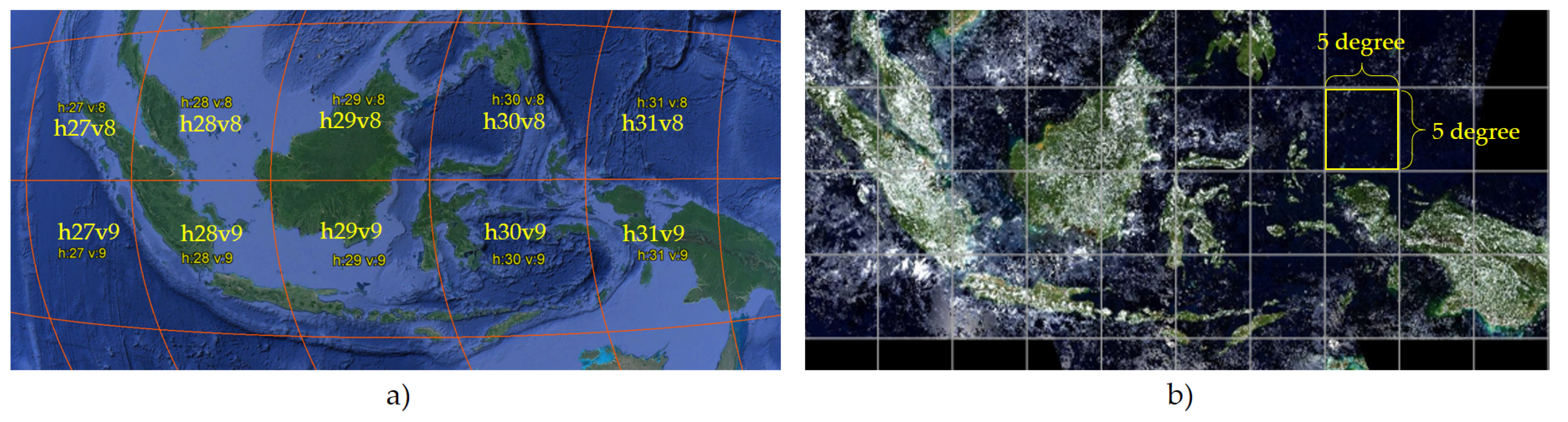
Figure 2.
Illustration of filtering procedure by: a) linear interpolation to estimate unknown values caused by cloud, b) median moving window over time series datasets.
Figure 2.
Illustration of filtering procedure by: a) linear interpolation to estimate unknown values caused by cloud, b) median moving window over time series datasets.
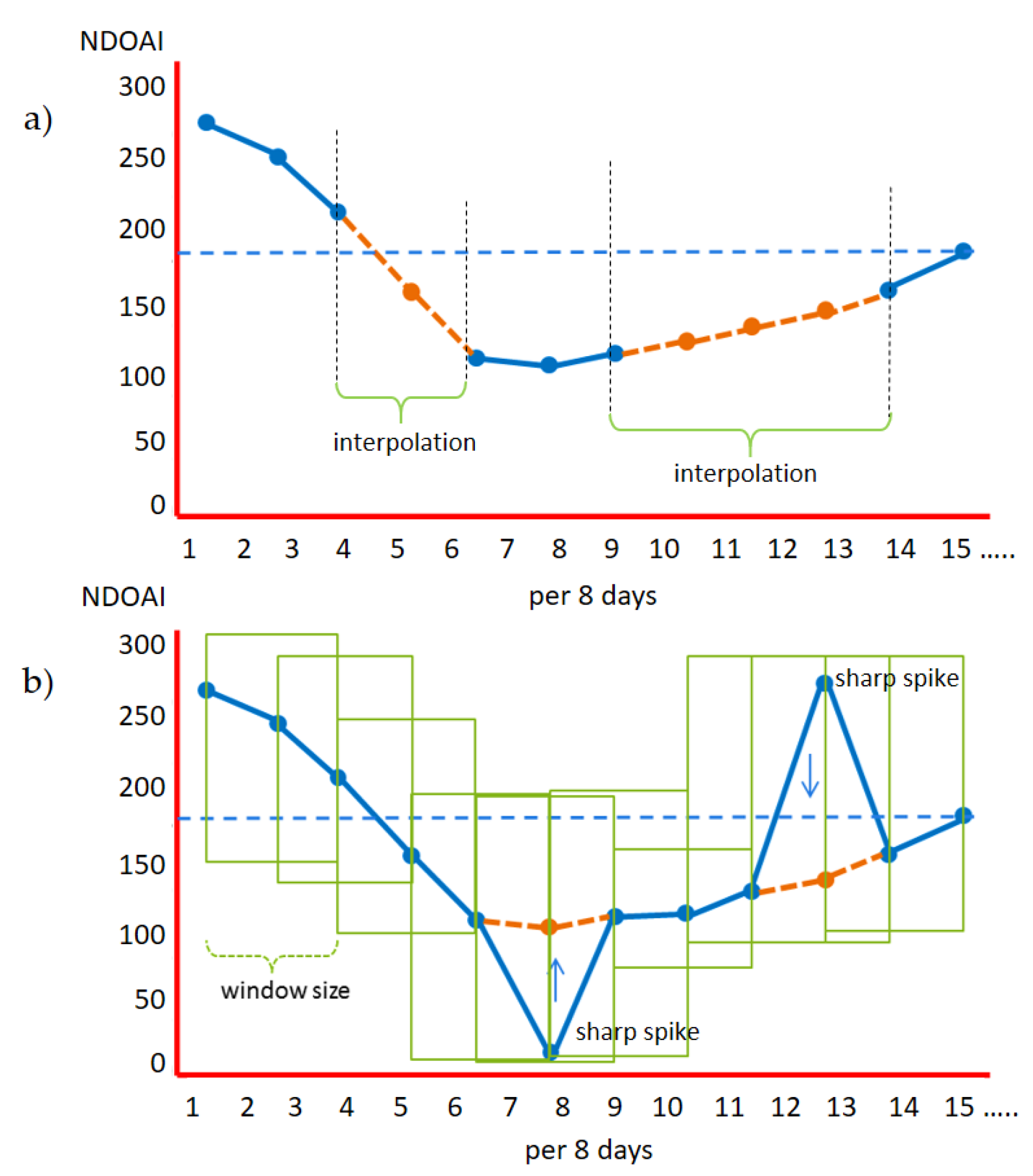
Figure 3.
Approach to a simple method for detecting vegetation changes based on difference of NDOAI value within a moving window every 8 days.
Figure 3.
Approach to a simple method for detecting vegetation changes based on difference of NDOAI value within a moving window every 8 days.
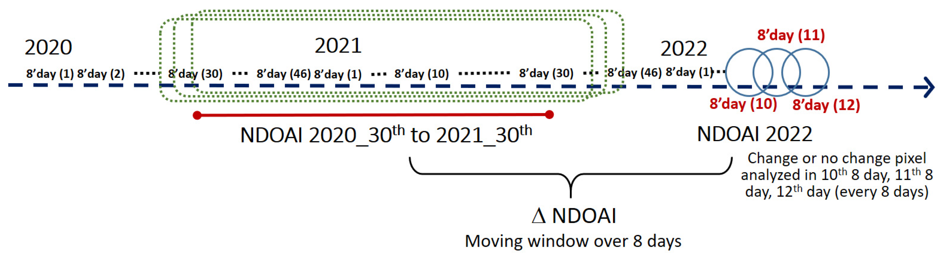
Figure 4.
Illustration of the change in NDOAI value pattern from the previous year datasets and subsequent 8-day data to detect vegetation cover change for every 8-day.
Figure 4.
Illustration of the change in NDOAI value pattern from the previous year datasets and subsequent 8-day data to detect vegetation cover change for every 8-day.
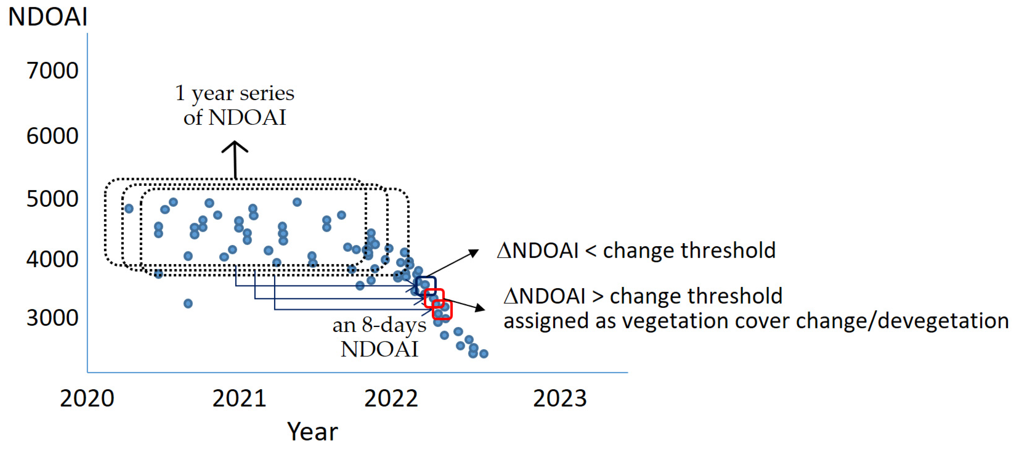
Figure 5.
(a) 1x1 degree fishnet selected for developing data reference (cyan), (b) VIIRS pixel size overlaid with Landsat ETM+ and high-resolution image with 100-point dot grid overlay.
Figure 5.
(a) 1x1 degree fishnet selected for developing data reference (cyan), (b) VIIRS pixel size overlaid with Landsat ETM+ and high-resolution image with 100-point dot grid overlay.
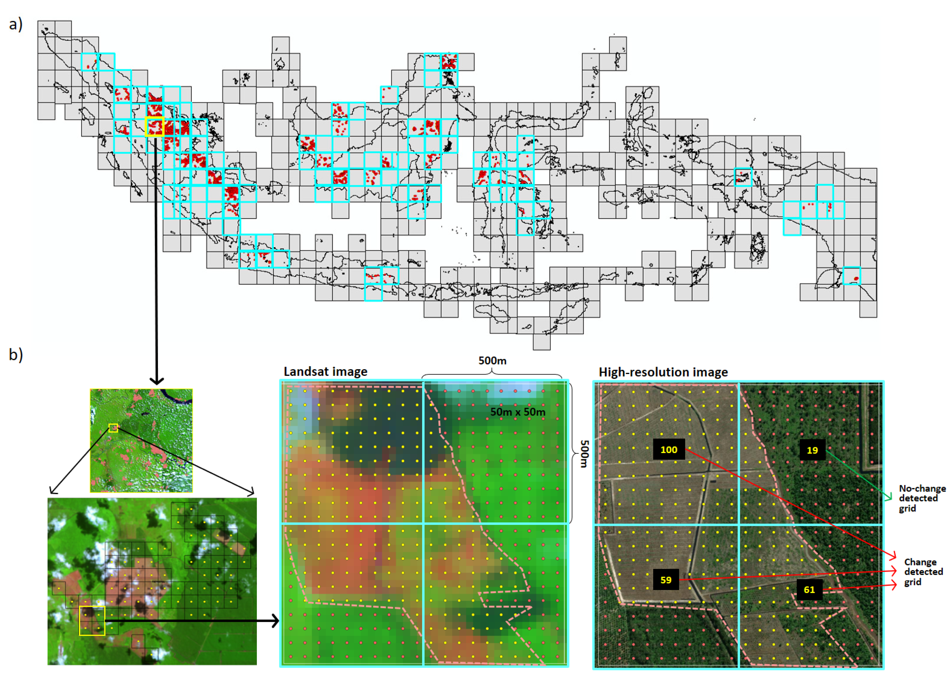
Figure 6.
Illustrating the distribution of samples relative to the percentage of Landsat-based open areas.
Figure 6.
Illustrating the distribution of samples relative to the percentage of Landsat-based open areas.
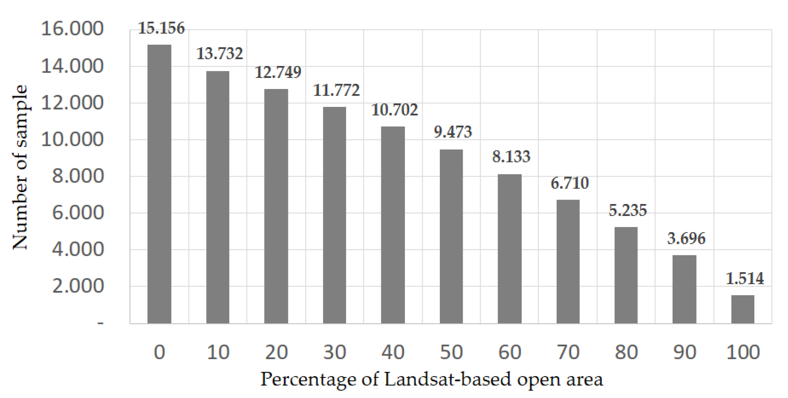
Figure 7.
Distribution of vegetation cover change in 2022 detected by the devegetation method.
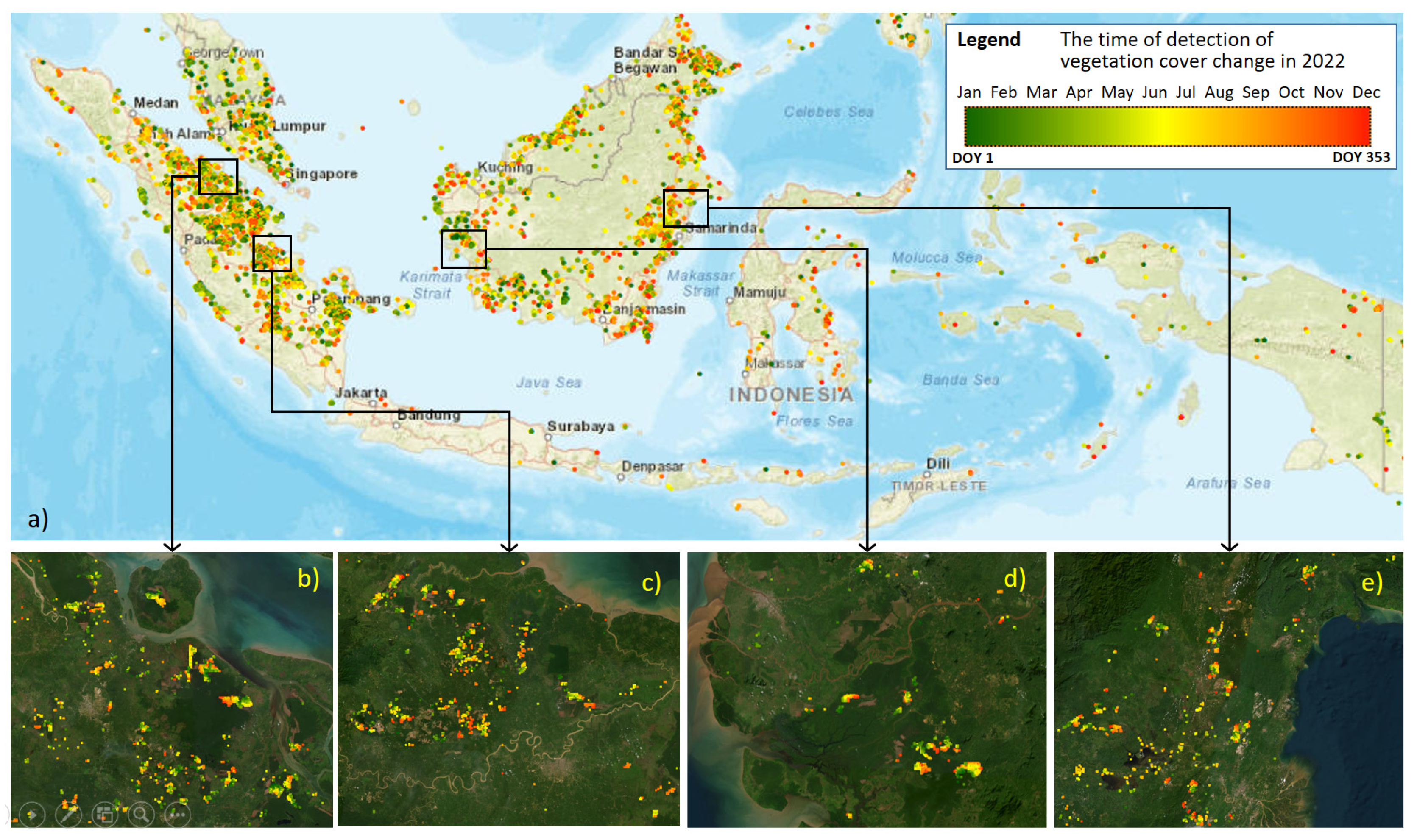
Figure 8.
The result of devegetation analysis conducted for the selected site in the year 2022 using a) VIIRS and b) Landsat.
Figure 8.
The result of devegetation analysis conducted for the selected site in the year 2022 using a) VIIRS and b) Landsat.
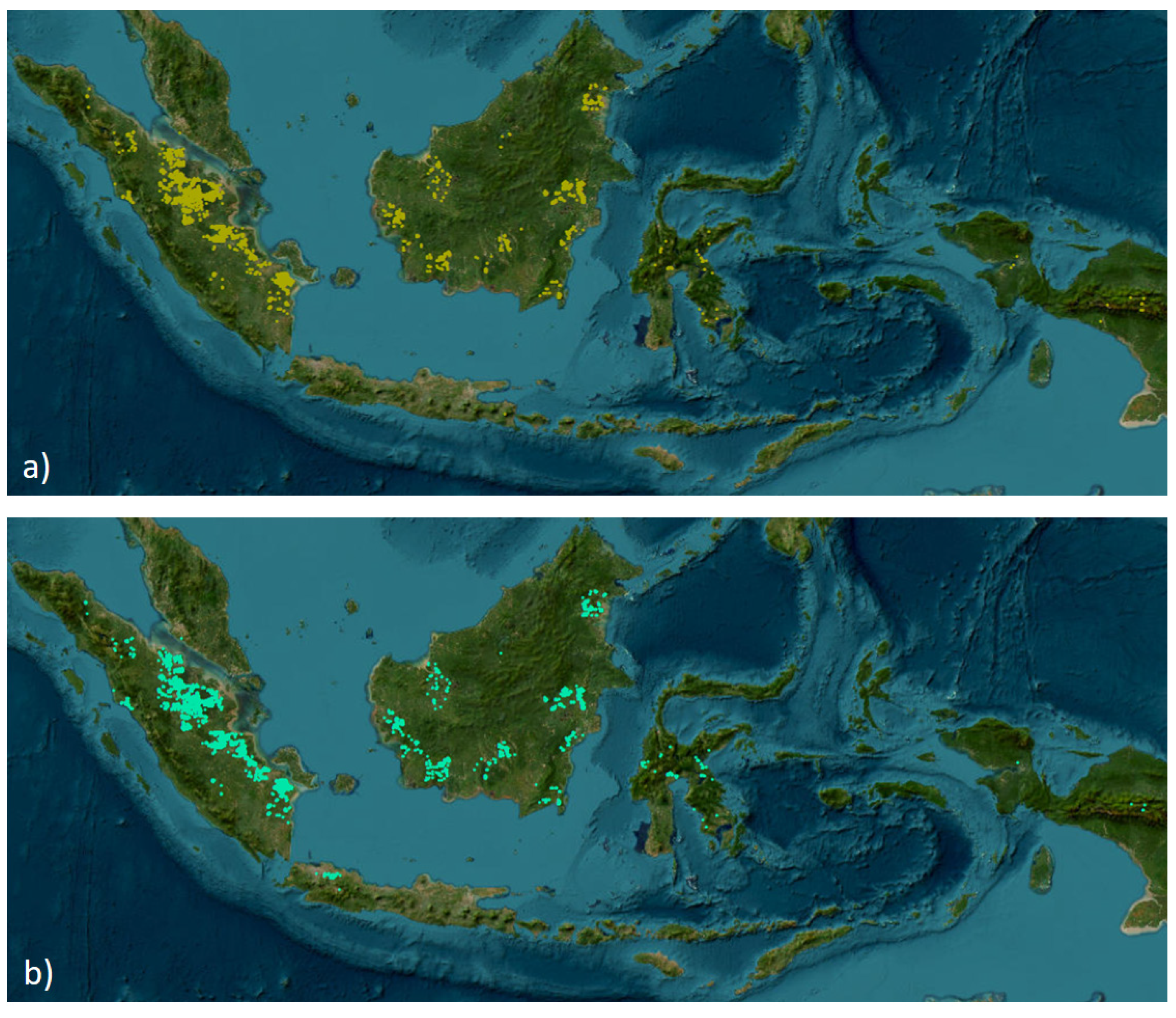
Figure 9.
Comparison of devegetation analysis results based on (a) VIIRS, (b) Landsat, and (c) Combination of both for the selected site in Riau, Sumatra.
Figure 9.
Comparison of devegetation analysis results based on (a) VIIRS, (b) Landsat, and (c) Combination of both for the selected site in Riau, Sumatra.
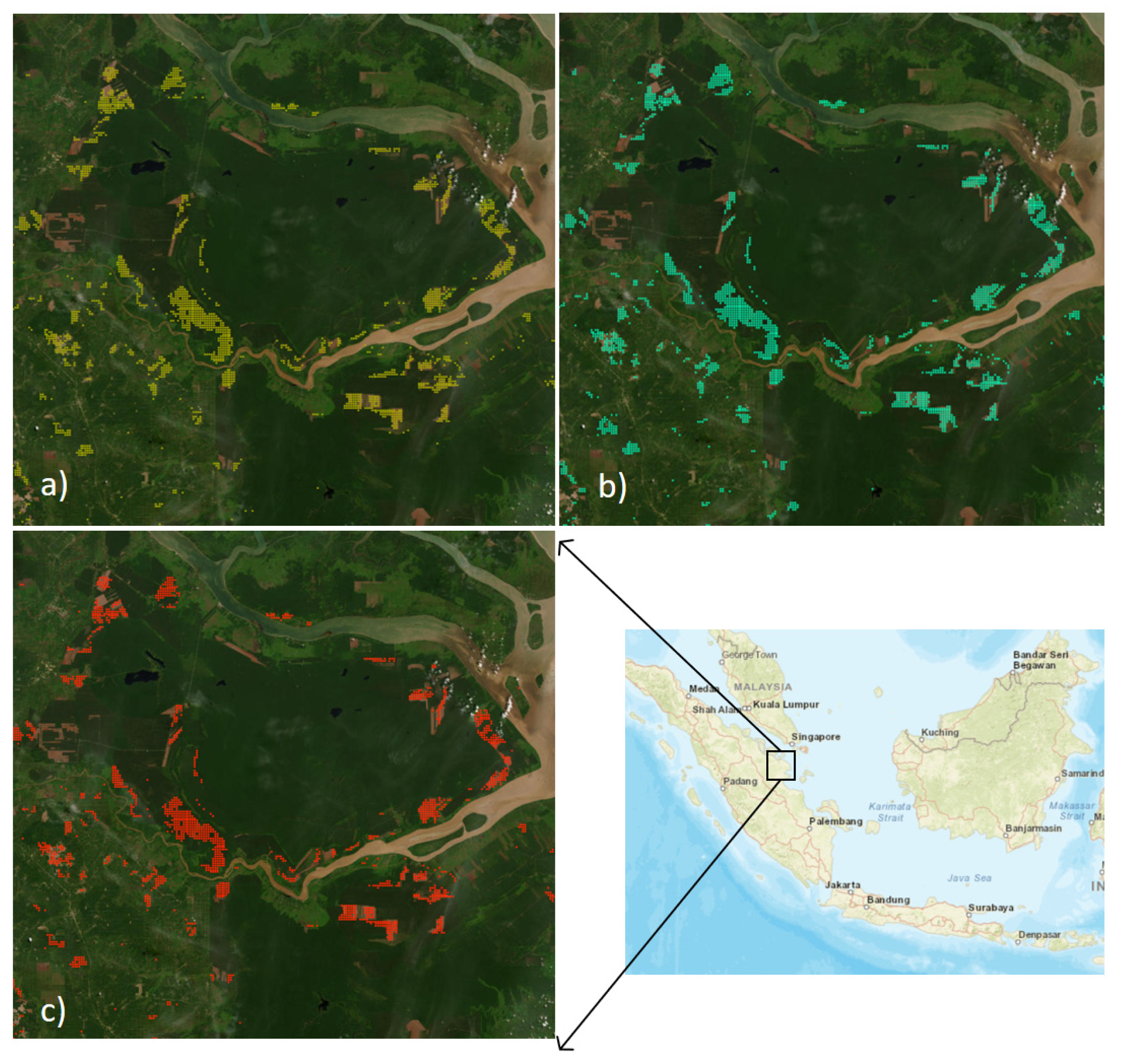
Figure 10.
A temporal comparison of the 16-day devegetation analysis results for the selected site in Riau, Sumatra, based on: a) VIIRS and b) Landsat data.
Figure 10.
A temporal comparison of the 16-day devegetation analysis results for the selected site in Riau, Sumatra, based on: a) VIIRS and b) Landsat data.
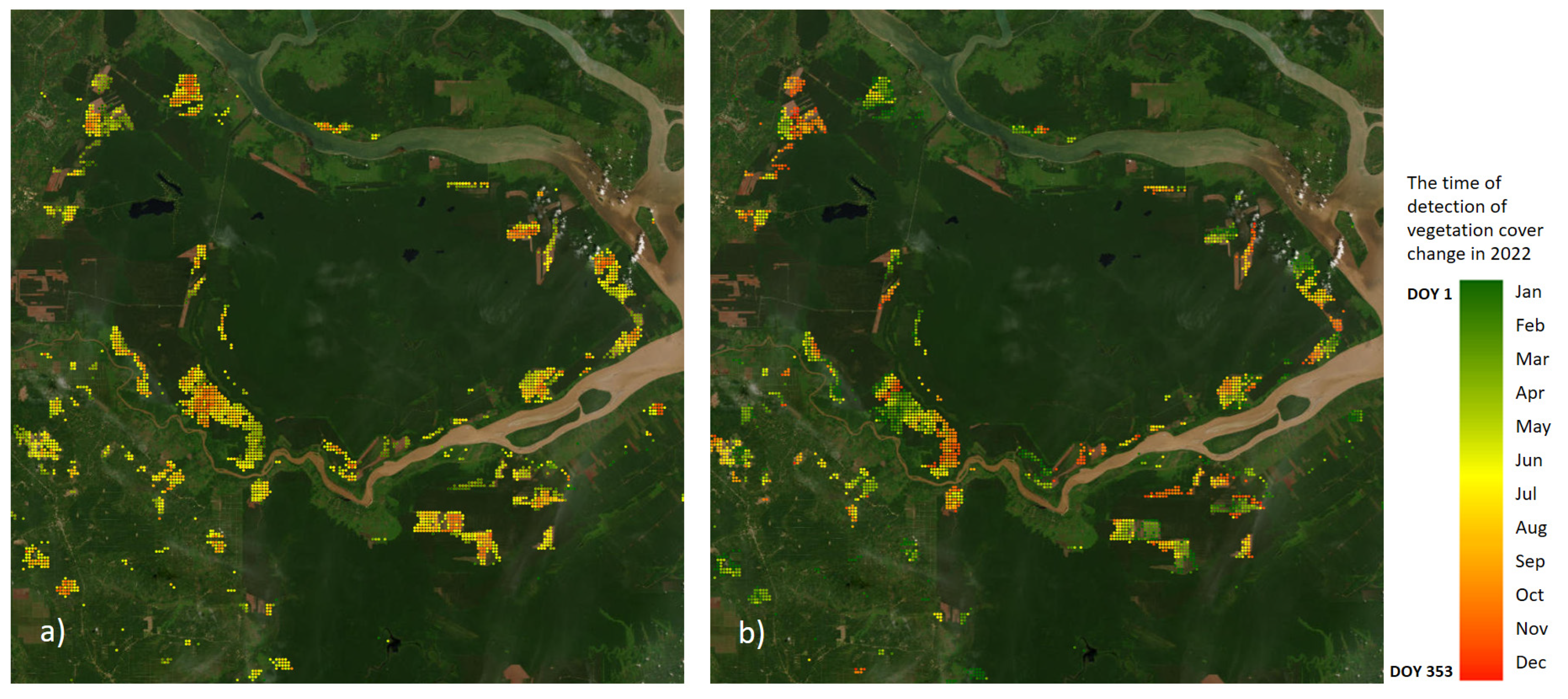
Figure 11.
The disparity in detection speed between VIIRS and Landsat using difference level of thresholds as a reference point; a) 5%, b) 20%, c) 40% and d) 75%.
Figure 11.
The disparity in detection speed between VIIRS and Landsat using difference level of thresholds as a reference point; a) 5%, b) 20%, c) 40% and d) 75%.
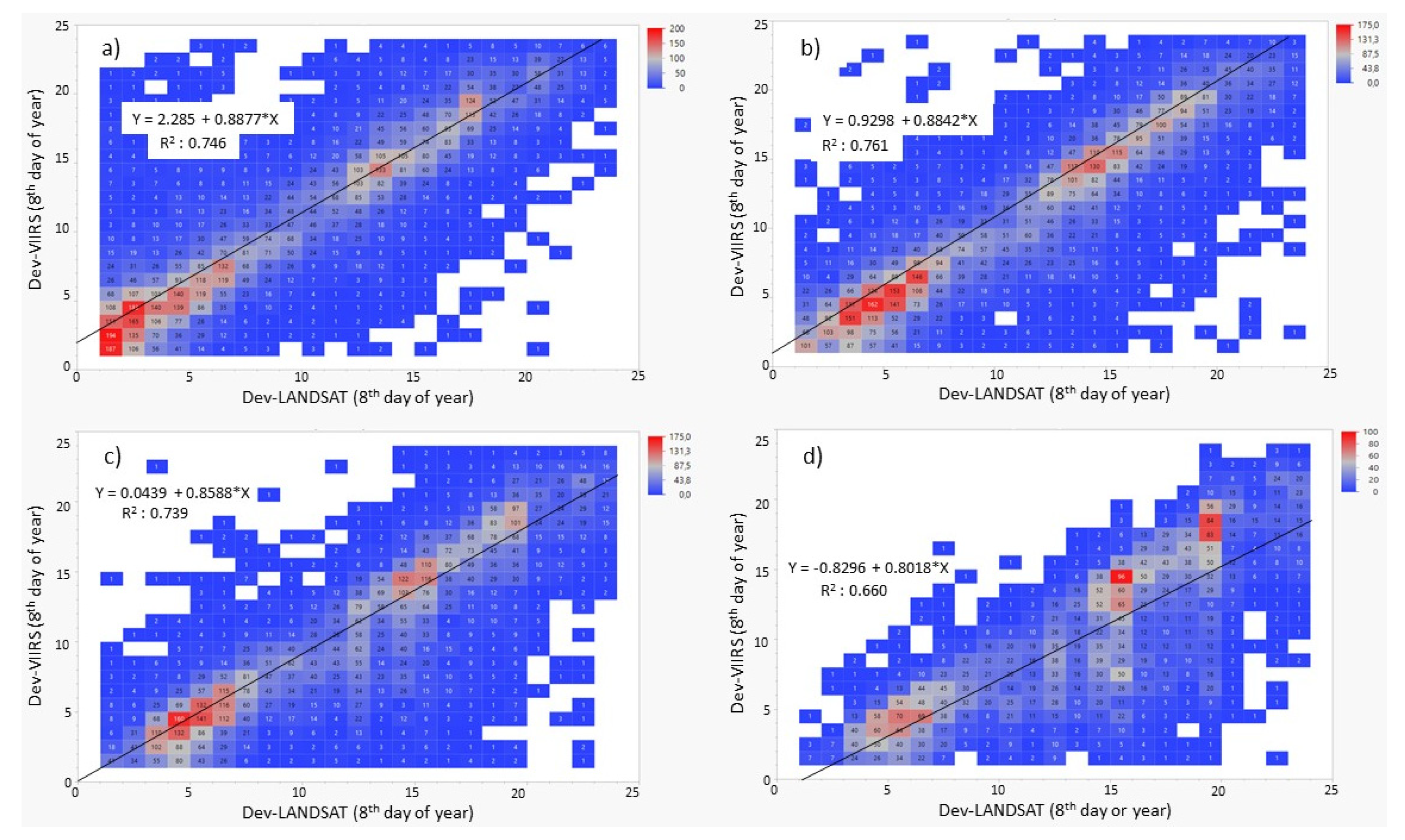
Figure 12.
A comparison of different time frames between VIIRS and Landsat-based datasets, highlighting alterations in specific regions identifiable through the application of a 20% threshold.
Figure 12.
A comparison of different time frames between VIIRS and Landsat-based datasets, highlighting alterations in specific regions identifiable through the application of a 20% threshold.
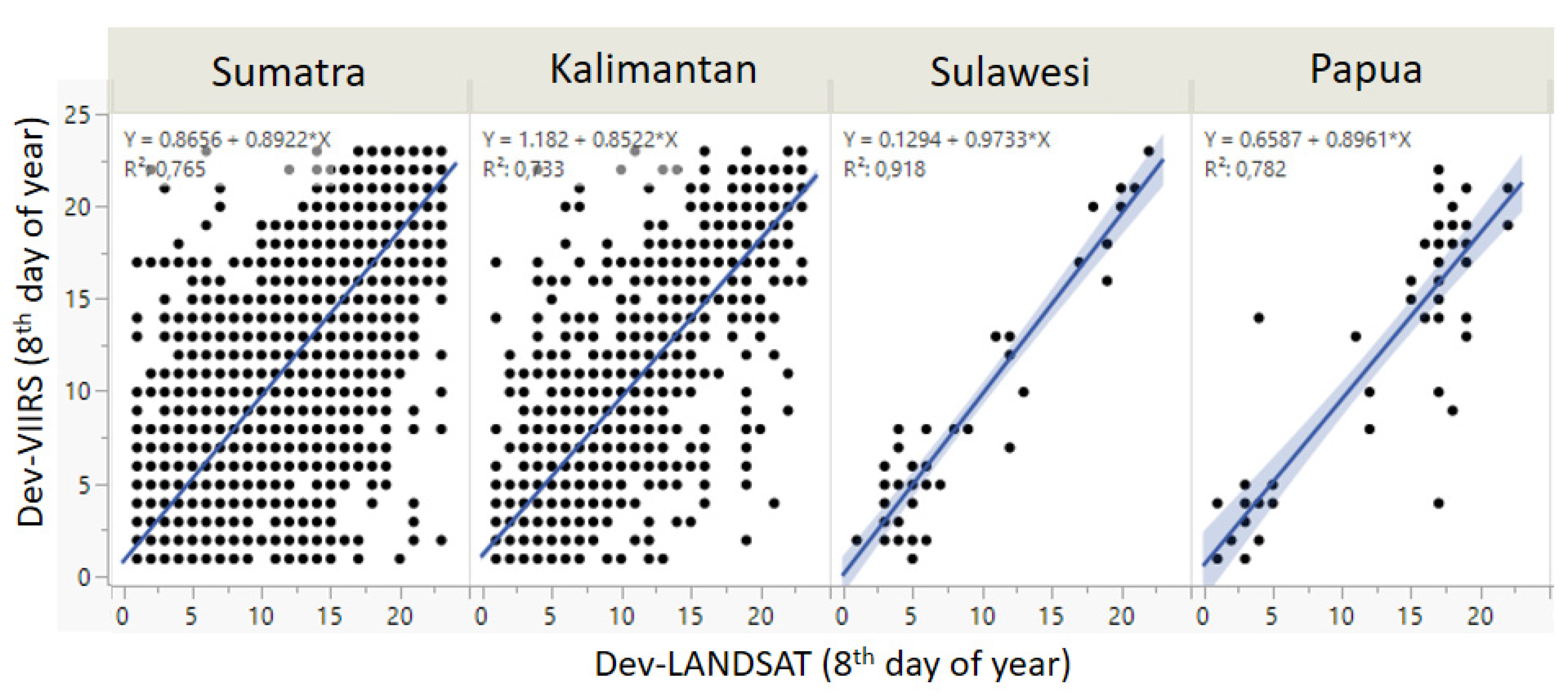
Figure 13.
The relationship between accuracy, sample quantity, and the thresholds.
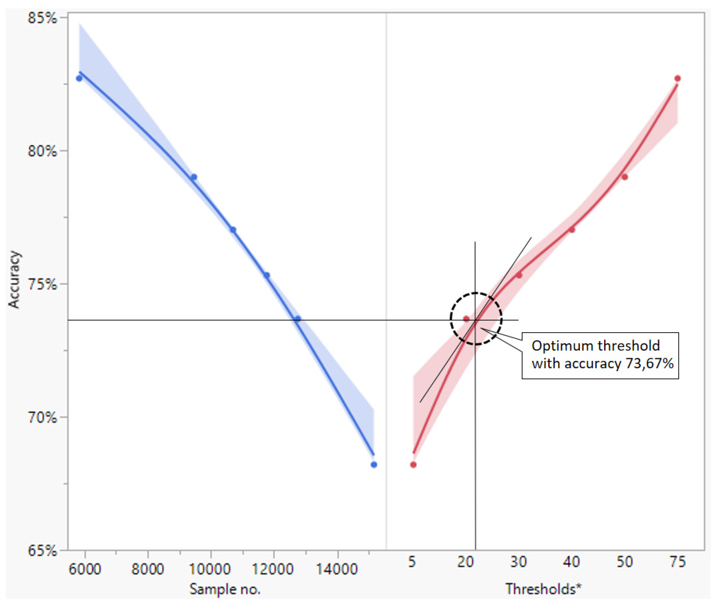
Figure 14.
Temporal discrepancy in detection time between VIIRS and Landsat based on on the threshold level set by the percentage of open area within a 500 x 500 m grid size.
Figure 14.
Temporal discrepancy in detection time between VIIRS and Landsat based on on the threshold level set by the percentage of open area within a 500 x 500 m grid size.
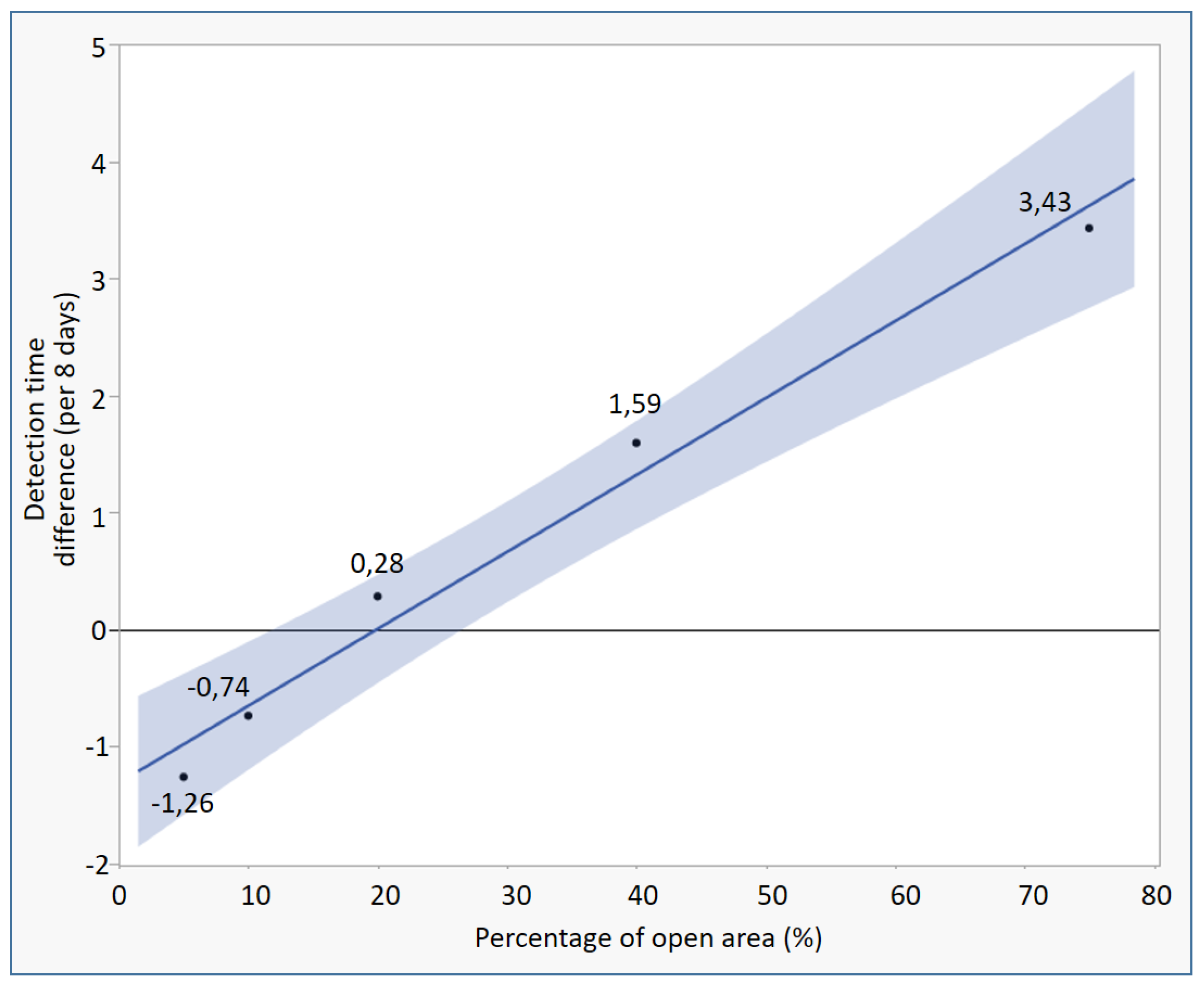

Table 1.
Accuracy assessment results with Landsat-based open area in a 500 m x 500 m grid.
| Percentage of open area (set as the threshold) |
Number of sample | Omission Err. | Accuracy |
|---|---|---|---|
| ~5% | 15156 | 31,80% | 68,20% |
| 20% | 12749 | 26,33% | 73,67% |
| 30% | 11772 | 24,69% | 75,31% |
| 40% | 10702 | 22,98% | 77,02% |
| 50% | 9473 | 21,00% | 79,00% |
| 75% | 5844 | 17,30% | 82,70% |
Disclaimer/Publisher’s Note: The statements, opinions and data contained in all publications are solely those of the individual author(s) and contributor(s) and not of MDPI and/or the editor(s). MDPI and/or the editor(s) disclaim responsibility for any injury to people or property resulting from any ideas, methods, instructions or products referred to in the content. |
© 2024 by the authors. Licensee MDPI, Basel, Switzerland. This article is an open access article distributed under the terms and conditions of the Creative Commons Attribution (CC BY) license (http://creativecommons.org/licenses/by/4.0/).
Copyright: This open access article is published under a Creative Commons CC BY 4.0 license, which permit the free download, distribution, and reuse, provided that the author and preprint are cited in any reuse.


