Submitted:
02 April 2024
Posted:
02 April 2024
You are already at the latest version
Abstract
Tidal notches, long regarded as reliable indicators of mean sea level, have been extensively studied along carbonate coasts in the central Mediterranean Sea. Previous studies revealed a correlation between the genesis of tidal notches and tidal range, lithology, cliff foot depth and wave energy. In the 2020 Geoswim campaign at Lampedusa, the southernmost island of the Pelagie archipelago (Italy), 'anomalous' tidal notches were identified. Unlike normal notches observed elsewhere, those in Lampedusa's southern bays exhibited a particular behavior —constantly deepening in the inner part of the bays, reaching a maximum depth of approximately 30 cm below sea level and narrowing inwards. Similar phenomena were previously observed by [1] near Marseille (France) and in Gozo Island (Malta). Time-lapse images, alongside measurements of morphometric param-eters, were collected during the survey. Despite the rapid morphological changes of the notches within the bay, the tectonic stability of the studied areas was confirmed by literature and data. Our hypothesis indicates that a combination of marine factors, influenced by local meteomarine conditions driven by the local morphology of the small bays exposed to southern quadrants con-tribute to the formation of these unique landforms. The latter manifest higher lowering erosion rates slightly below mean sea level in sheltered areas, challenging conventional notions about tidal notch formation.
Keywords:
Coastal landforms
; Rock coast geomorphology
; Mediterranean Sea
; Tidal notches
; Sea level markers
1. Introduction
Tidal notches are horizontal grooves found on sea cliffs, typically at the mid-tide mark, and they serve as geological markers and recorders of past sea levels [1]. The formation of tidal notches is a result of the erosive action of waves, as well as the chemical and biological weathering of the rocks [1]. A seminal work by Antonioli et al. [2] published in 2015 examined 73 coastal sites in the central Mediterranean Sea. This study measured notch widths and depths, reported the biological rim characteristics, and established correlations with wave energy, tidal range, and rock lithology. Subsequently, the Geoswim program, as part of an ongoing field work [3,4], sought to collect visual observations and instrumental data across extensive rocky coast sectors, emphasizing the correlation of these data with sea level changes.
Our study delves into a particularly intriguing geomorphological context, or the innermost sectors of some long and narrow ria of the Mediterranean basin in areas characterized by stable tectonic behaviour. Here, Antonioli et al. [5] reported "anomalous" tidal notches, i.e. that we call dipping tidal notches (DTN). The authors observed that the maximum retreat point of tidal notches gradually deepened from exposed to sheltered locations within ria. They suggested that these landforms result from various processes, influencing the cliff's lowering at different rates.
Our exploration, rooted in the Geoswim program's comprehensive approach, aims to unravel these tidal notches' intricate dynamics, mainly focusing on their anomalous behaviors observed in the study area. We seek to contribute to the evolving understanding of sea level indicators and their geological implications through detailed surveys and data collection.
1.1. Lampedusa Island (Italy)
Lampedusa, the southernmost island in Italy, belongs to the Pelagie Archipelago which is located in the southern sector of the Sicily Channel. Spanning 10 km in the east-west direction, the island covers 20 km² and boasts a rugged coastline extending over 33 km (Figure 1a). The study area encompasses, two small bays, both located along the southern coast of the island: Cala Madonna and Cala Creta.
From a geological point of view, Lampedusa island is the emerging portion of a wide, WNW-ESE trending plateau [6] where Tortonian to Messinian succession of Porites coral bound stones and bioclastic calcarenites with abundant fossil content (mollusca, bryozoan, echinoid and algal fragment) outcrop [7,8] .
The island belongs to the undeformed African foreland and the overall attitude of Late Miocene sedimentary strata as well as the elevation of MIS 5.5 infralittoral deposits [6] both suggest a general tectonic stability almost during Quaternary [7], except for vertical displacement mostly occurred during Calabrian time interval [9,10].
The tide amplitude at Lampedusa is about 40 cm. Wind data from 1999 to 2022 [11] sourced from ENEA Lampedusa [12](https://www.lampedusa.enea.it/), indicates prevailing winds from the northwest, notably the Maestrale wind.
Lampedusa's precipitation pattern follows a distinct seasonal trend, with December being the wettest month, registering 61 mm, while July is the driest month with no recorded precipitation [11].
1.2. Southern Gozo Island (Malta)
The island of Gozo (65.79 km2) is part of the Maltese archipelago located in the middle of the Mediterranean Sea [13], in the Sicily Channel (Figure 1b), between Sicily northward and the African coasts westward. From a geological point of view, a sedimentary sequence composed of carbonate rocks spanning in time from Upper Oligocene to Upper Miocene crops out in Malta and Gozo. Along the coast, four formations outcrop: Lower Coralline Limestone Formation (Chattian), Globigerina Limestone Formation (Aquitanian-Early Langhian), Blue Clay Formation (Langhian-Tortonian) and Upper Coralline Limestone Formation (Late Tortonian-Early Messinian) [14]. The topography of Gozo is controlled by the horst and graben system expanded during the Miocene and Plio-Quaternary extensional stages [13,15].
Most valleys are rias, previously excavated by fluvial processes, but today practically inactive [16]. The climate is Mediterranean and is strongly influenced by the sea [17]. The relatively flat morphology of the islands does not favour rainfall formation. On average, the island receives 530 mm of yearly rainfall [18]. Many small submarine freshwater springs have been surveyed along the island during the 2013 Geoswim campaign [19]. The island is affected by long fetches, mainly in the second and fourth quadrants and dominant winds come from NW [20].
Tidal oscillations, predominantly semidiurnal, reach a maximum range of only 20.6 cm on average for spring tides and is reduced to 4.6 cm during neap tides [21].
1.3. Cassis (Southern France)
In southern France, massive Mesozoic limestones outcrop at Marseille and the Calanques coastal area (Figure 1d). From a tectonic viewpoint, several authors, such as [6,22] suggested that this region has been stable since the last interglacial, with weak vertical land movements in the area between Nice and Menton [23]. The sea level position during the MIS 5.5 and the tidal notches of the same age are still poorly known in this area, likely due to the non-conservative behaviour of local lithology and to the lack of aeolian sediments that could have buried and preserved FTNs, such as in other areas of the Mediterranean basin (e.g. at Orosei Gulf, [24]). Regarding the relative sea level dataset published for the late Holocene, [25] provided biological estimates based on fossil calcareous algae sampled on sea cliffs placed up to about 1.3 m a.s.l. and formed during the last 5 ka. For the last 2 ka BP, geoarchaeological data of the Roman age, like the port of Marseille and the fish tanks at Frejus [26,27], show a mean altitude of about 0.5 m a.s.l., in agreement with predicted sea levels curves [28].
The maximum tide amplitude in southern France is approximately 0.1 m, but the sea level can rise up to 1.5 m with specific local meteoclimatic conditions [26]. Wind data indicate prevailing winds from the fourth quadrant, or Mistral, and secondarily from east.
2. Tidal Notches, Roof Notches, Abrasional Notches and Dipping Notches
As we navigate this investigation, we draw on the [1] definition, describing notches (littoral notch, marine notch, coastal notch, or wave-cut notch, visor) as deep, narrow cuts or hollows along the base of sea cliffs near the high-water mark, with the depth being smaller than its width [1].
Modern Tidal Notches (MTNs) on rocky coasts are well developed in the Mediterranean Sea because of its microtidal regime, and they can be found along most of its perimeter. Antonioli et al. [2] described the morphometric parameters of 73 Modern Tidal Notches (MTNs) in the Mediterranean area. They attributed the occurrence of MTNs to a range of marine processes, such as bio-weathering, chemical dissolution, and wave action that act together, eroding rocks at the mid-tide level. The authors [2] suggested that over the last 6.8 ka, MTNs have changed their shape following the relative sea level rise, causing sea cliff retreat. Fossil Tidal Notches (FTNs) are laterally extending hollows below or above the sea level that were carved in the past when the relative sea level was at the elevation of the notches. When the base of the notch is missing, such as in Istria (Croatia) [29,30] or in Gozo (Malta) [19], it is called a Roof Notch (RN).
Roof notches are often observed in carbonate rocks, and they can result from various processes such as biological agents, wetting and drying cycles coupled with salt weathering, hyperkarst processes, and mechanical erosion[2].
Double notches, or a kind of fossil notch coupled with a fossil or modern one (Figure 2a), have been described by Antonioli et al. [31] at some sites, such as at Orosei Gulf (Sardinia, Italy) in the Mediterranean Sea. The two notches show an average vertical separation of roughly 2–4 m. They are systematically observed at an elevation of a few meters above present-day sea level on tectonically stable coastal sites, mainly in western Italy. The upper notch has a morphology like the one developed at present-day mean sea level under the current tidal regime. The lower notch is smoother than the upper notch and shows a larger vertical size with respect to the upper one. This is the Smoothed Tidal Notch (STN). Moreover, it is pervasively bored by Lithophaga lithophaga and other boring species. Fossil notches have been attributed to the MIS 5.5 stage (last interglacial) based on a quantitative assessment of the glacial isostatic adjustment (GIA) expected at each site from updated models. Authors [31] argued that both notches within the couplet were formed during a single high stand of the Marine Isotopic Stage (MIS) 5.5 substage, and the superposed morphology resulted from the isostatic component.
To sum up, based on the observations of Antonioli et al.[2,31,32], when carbonates are very conservative and resistant to erosion, such as in the sites described in the central Tyrrhenian Sea by the authors, the following succession of notches, from top to bottom, as illustrated in Figure 1a can be found: FTN, smoothed notch, MTN, and smoothed submerged notch. The latter always shows widths lower than the fossil notch.
Abrasional notches (ANs) are lateral extending hollows developing above or below the modern sea level due to wave action at the sea bottom and favored by the presence of sand or pebbles. They can occur up to 25-30 m in depth, depending on the local tide and wave energy.
Recently, Antonioli et al. [6] described a particular kind of notches at Cassis (Southern France) that develop below the sea level at the innermost sectors of the small ria, or coastal inlets formed by the partial submergence of a river valley in contrast with the tidal notch exposed at the sea level in the areas outside the rias, a few hundred meters away. We suggest calling them Dipping Tidal Notches (DTNs) due to their progressive deepening towards the interior of the ria. Vacchi et al. [33] described in a sheltered coastal area in the Friul Archipelago (Marseille, France) a submerged notch at -0.35 m. The authors did not tell the roof notch above the submerged one. They attributed the genesis of the submerged notch to the sea level elevation between 1.5 ka and 1.0 ka, the Little Ice Age (LIA) cool period, or about -0.5 m below the modern sea level. It was also carved in a sheltered area without waves and other boring species.
2.1. DTNs in Southern France
In southern France, Antonioli et al. [6] observed and measured several sites in which a roof MTN with significant morphological continuity occurs, extending with the same features for about 4 km South of Marseille (Figure 3). It is a roof notch carved in Mesozoic limestones having morphometric shapes and sizes in agreement with those described by Antonioli et al., [2] for the central Mediterranean. At the time of surveys, MTN showed a strip of about 60 cm wide of calcareous red algae grown above the Cystoseira sensu lato canopy. The seabed in this section is at most 2 m in depth. MTN also occurs at the Sormiou canyon, carved on the limestones of the Barremian facies (Urgonian level), and at Cassis. This area is located near the tide gauge station of Marseille (see Methods). At Cassis, MTN displayed a homogeneous and continuous morphology at the mouth of a small ria (Figure 3a) at an exposed site (Figure 3b, c, d). In contrast, in the inner part of the ria (Figure 3e, f), its width is 0.28 m, and it was completely submerged, such as what we call Dipping Tidal Notches (DTN). Lithodome bores carve limestones above the notch, and they were probably drilled during the last Interglacial at an altitude from 3 m to 5 m a.s.l. The authors [6] also reported the presence of a layer of freshwater on the sea surface, with a thickness of some cm. Here, the mean sea level is marked by a crust of coralline red algae placed at the base of the notch (Figure 3d).
2. Methods
The studied sites have been investigated through swim surveys performed close to the coast as described in [3,4]. The occurrences of MTN and roof MTN were located and mapped, and notch morphometry was measured by fixed or extensional rods, following Antonioli et al. [2]. Data reported in Table 1 were corrected for tides and pressure using the methodology described in [34], using tidal data from the nearest tide gauge station [35] (www.mareografico.it;ioc-sealevelmonitoring.org/), in particular at Lampedusa where measured data have been collected (Figure 4), while positions have been estimated at the surface by GPS handheld receivers.
The tide corrections were provided by the Lampedusa monitoring station, which is part of the National Tide Gauge Network from the Istituto Superiore per la Protezionee la Ricerca Ambientale (ISPRA). The Tide Gauge is located at ~1.5 km from the ria of Cala Madonna, and it provides online data from 2010.
We performed photographic acquisition to model the MTNs studied here. These models were used to compare MTNs and DTNs at the reviewed sites. These high-resolution (HR) images were taken above and below the waterline, as described in Furlani et al. [36] using GoPro Hero 6 Black cameras. A total of 154 images of the emergent part and 534 of the submerged part were acquired and processed separately using the software Agisoft MetashapeTM (Agisoft LLC, St. Petersburg, Russia) to produce the dense point cloud and 3D model of the cave, according to the DP technique. The first part of DP is known as the SfM technique and involves the importation of images of each outcrop and camera alignment. Collected images were imported in MetashapeTM.
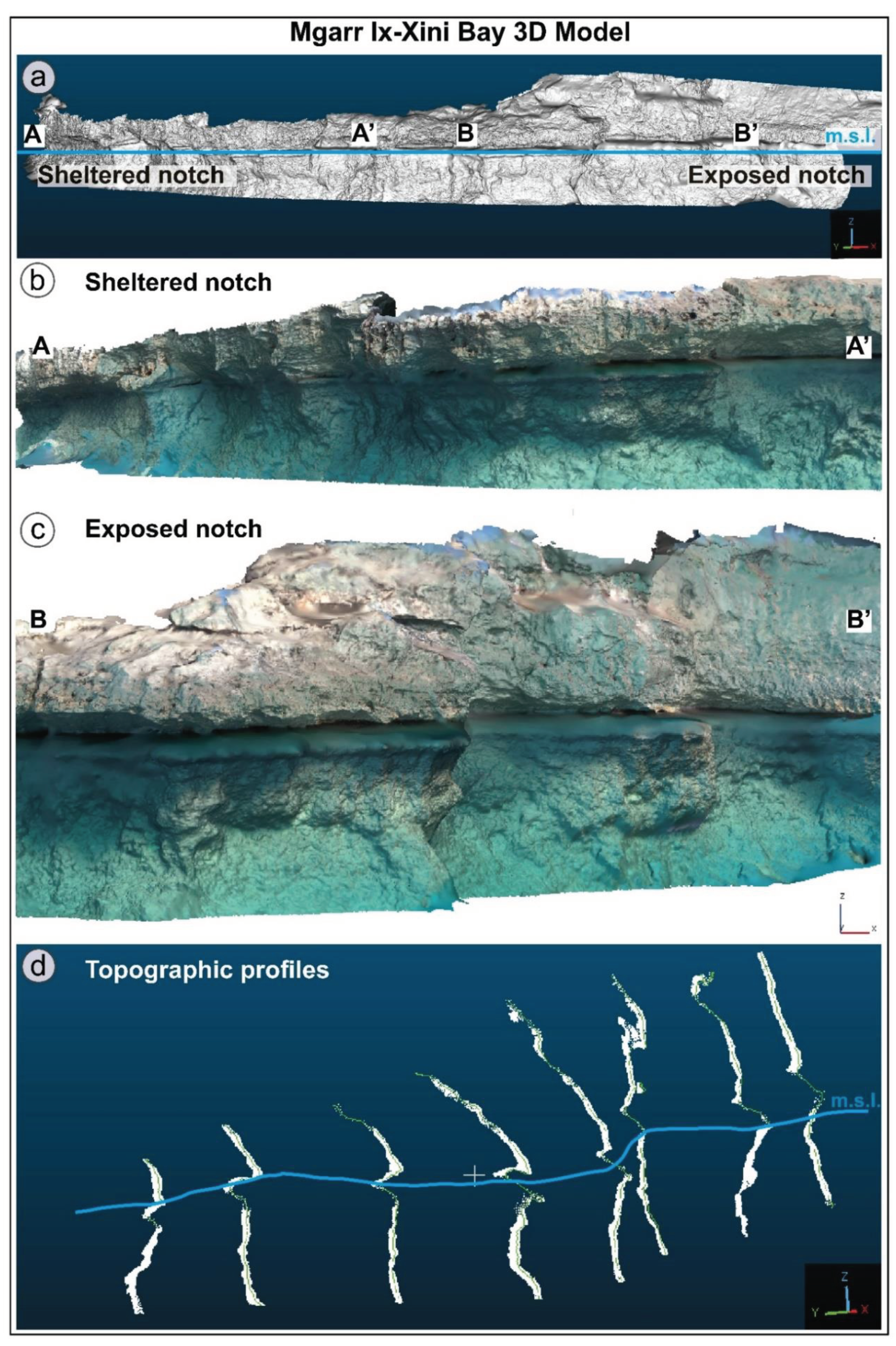
It includes SfM algorithms that allow the user to align the images and calculate their relative position to each other during the camera alignment phase. The outcome of the camera alignment process was a sparse point cloud of the investigated stretch of coast. Agisoft Metashape software facilitated the integration of 3D models depicting a specific section of Mgarr Ix-Xini Bay. Five hundred thirty-four images have been taken above and 534 below the waterline. Then, they were utilized to reconstruct separate 3D models. The merging process relied on depth maps generated from these models. The resulting composite 3D model is geolocated and dimensionally measurable, with all procedures executed within the same software platform. The finalized merged model was exported in .obj format and subsequently analyzed in Cloud Compare software to derive topographic profiles of its outermost region.
The second part of DP is known as MVS reconstruction, which involves dense point cloud production, mesh production, and the generation of a 3D textured model (Figure 7). The low-density point cloud is thickened by increasing the number of points to generate a dense point cloud. The final steps included the production of a 3D surface, called mesh, and the generation of a 3D textured models.
3. Results
We present data collected at the two sites above, respectively, at Lampedusa (par. 3.1) and Gozo Island (par 3.2).
Data collected in the field are reported in Table 1, together with data reported by [5] at Cassis (France).
3.1. Cala Madonna (Southern Lampedusa Island)
At Lampedusa, MTN was observed and measured along most of its rocky coasts. At the southern side of the island, at the mouth of a small ria called Cala Madonna, the top of the roof of MTN (Figure 4, site 1 in Table 1).At Cala Madonna, the top of the MTN was measured at an altitude of 0.08±0.025 m that corrected with tide of 0.47 m (detail in Table 1), resulting in an altitude from the bottom of MTN of 0.05 m. The shape of MTN shows the morphometric features of notches studied by [6], with a small platform at the base. Moving towards the inside of the ria the MTN progressively lowers up to an altitude of -0.50 below sea level (Tab. 1). Moreover, the depth of the notch, or the carving depth, decreases from 0.60 m on the outside of the ria to 0.34 on the inside. The only TN that always remains completely submerged after tide corrections is TN at site one, located at the innermost part of the ria (Tab. 1, Site 1).
The biological rim shows an assemblage composed mainly of calcifying red algae, both encrusting (e.g., Goniolithon papillosum) and erect (e.g., Jania rubens and Ellisolandia elongata) [37]. Along the subtidal, there are also numerous bioerosion scars, probably due to the action of the sea urchins Paracentrotus lividus and Arbacia lixula, frequently current in the images. Although a Vermetid carpet is sometimes present, signs of sea urchin bioerosion are very frequent along the entire coast examined.
3.2. Mġarr-Ix-Xini (Southern Gozo Island)
Along the Gozitan coast, MTN was observed almost continuously around all carbonate sectors [19]. At the southern side of the island, at the mouth of the small ria called Mġarr Ix-Xini, the top of the roof of MTN was measured at a corrected altitude of 0.08±0.025. The shape of MTN shows the morphometric features of notches studied by [6], with a small platform at the base. Moving towards the inside of the ria, the MTN progressively lowers up to an estimated altitude of 0.50 below sea level (Table 1). Moreover, the depth of the notch, or the carving depth, decreases from 0.60 m on the outside of the ria to 0.34 on the inside.
In the Gozo ria, benthic assemblages of the subtidal area are, above all, composed of turf-forming algae intermingled with brown algae of the family Dyctiotales growing on a substrate free of encrusting red algae. Turf-forming algae are probably related to a spatial variation in the deposition of suspended sediments [38]. The intertidal assemblage, however, presents a dense encrustation of crustose calcareous algae of Lithophyllum and Lithothamnium genera, surmounted by a strip of Chlorophyceae [39]. A huge number of holes due to mollusks of genus Patella is frequent along all the transect.
5. Discussion
Data collected at the two sites allow us to make the considerations following described:
1) for the first time, a continuous morphometric survey of the notch in the ria of Cala Madonna, from its sheltered to the exposed part, the latter outside the ria, has been carried out. The survey allowed to highlights that the “normal” MTN located outside Cala Madonna shows the shape usually reported by several authors in the Mediterranean area [2,40]. Measurements were collected in three surveying days, as reported in Table 1;
2) Antonioli et al. [2] described several MTNs in sheltered sites, such as Porto Badisco (Apulia, Italy), but no DTNs occur there. The sites studied in this paper are exposed toward south, with DTN on the innermost side.
3) corrected measures (Table 1) show that the transition from the DTN in the sheltered site and the MTN outside the ria occurs approximately in 250 m (Figure 5).
Figure 5.
Tide gauge data at Lampedusa. The red dots indicate the time of campaign data acquisition (data taken from [36] www.mareografico.it;ioc-sealevelmonitoring.org/).
Figure 5.
Tide gauge data at Lampedusa. The red dots indicate the time of campaign data acquisition (data taken from [36] www.mareografico.it;ioc-sealevelmonitoring.org/).
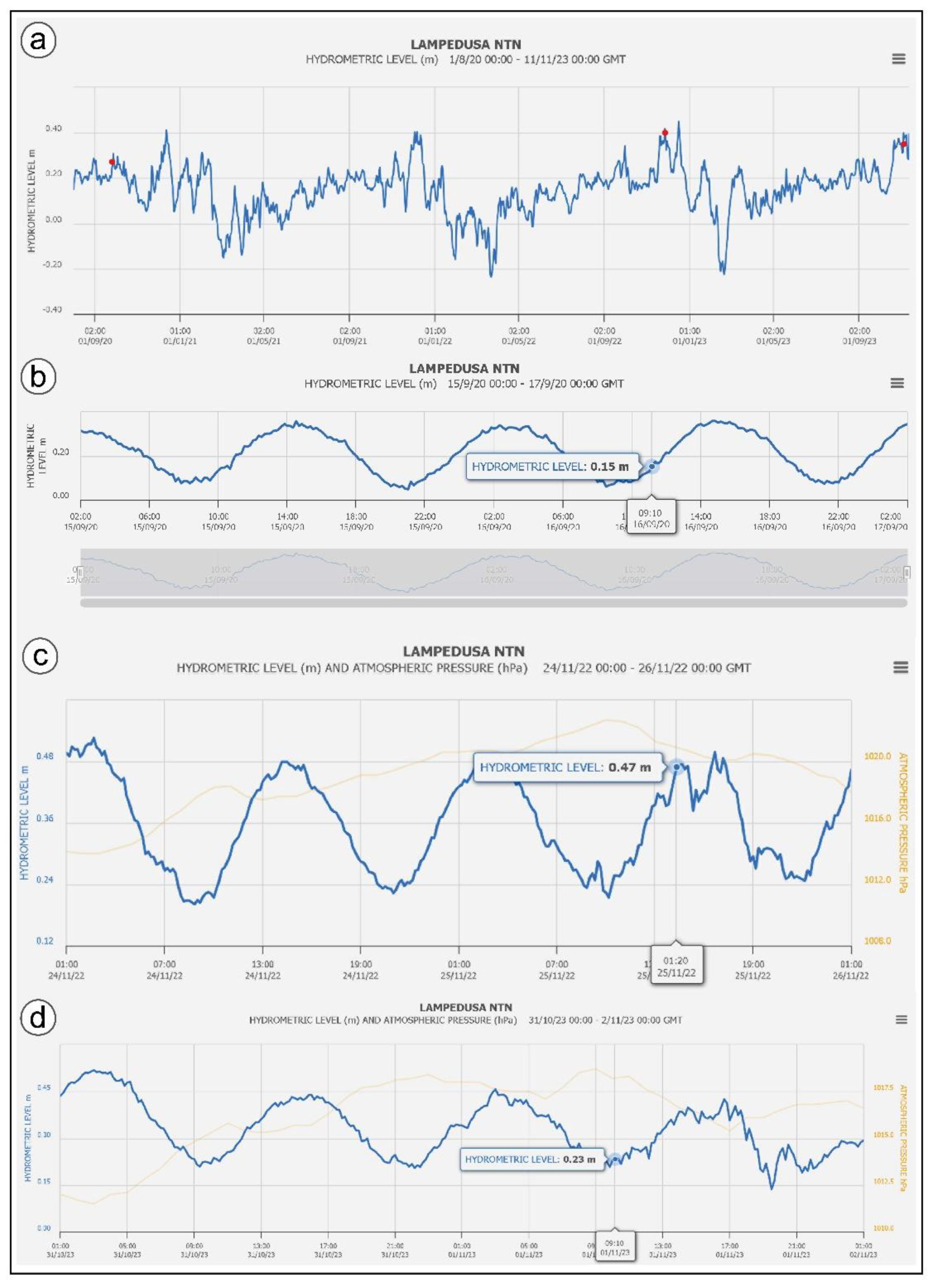
Figure 6.
Collection of images at the Lampedusa site.
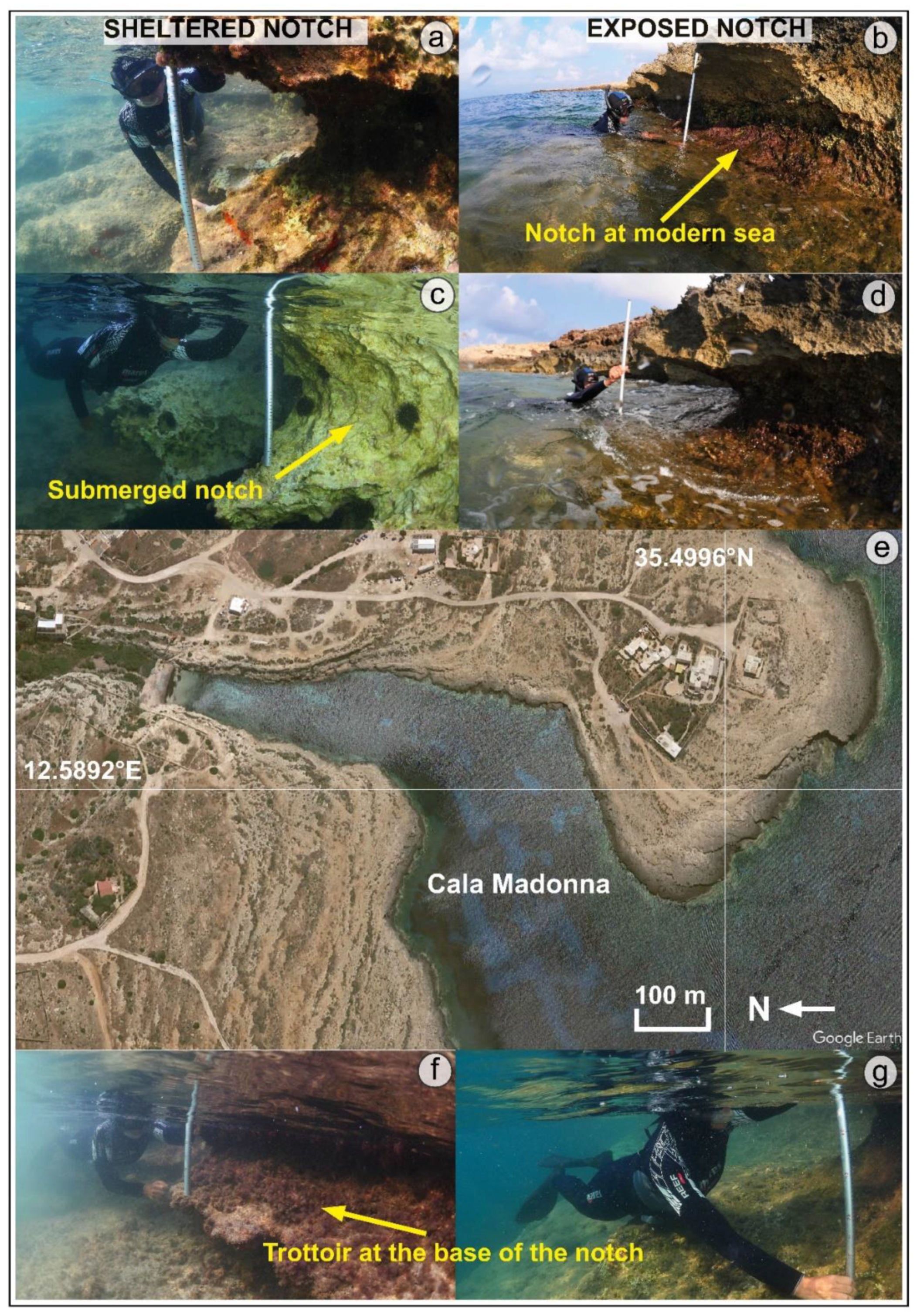
Figure 7.
Tidal notches and dipping notches at Lampedusa.
Figure 8.
Collection of images at the Gozo site.
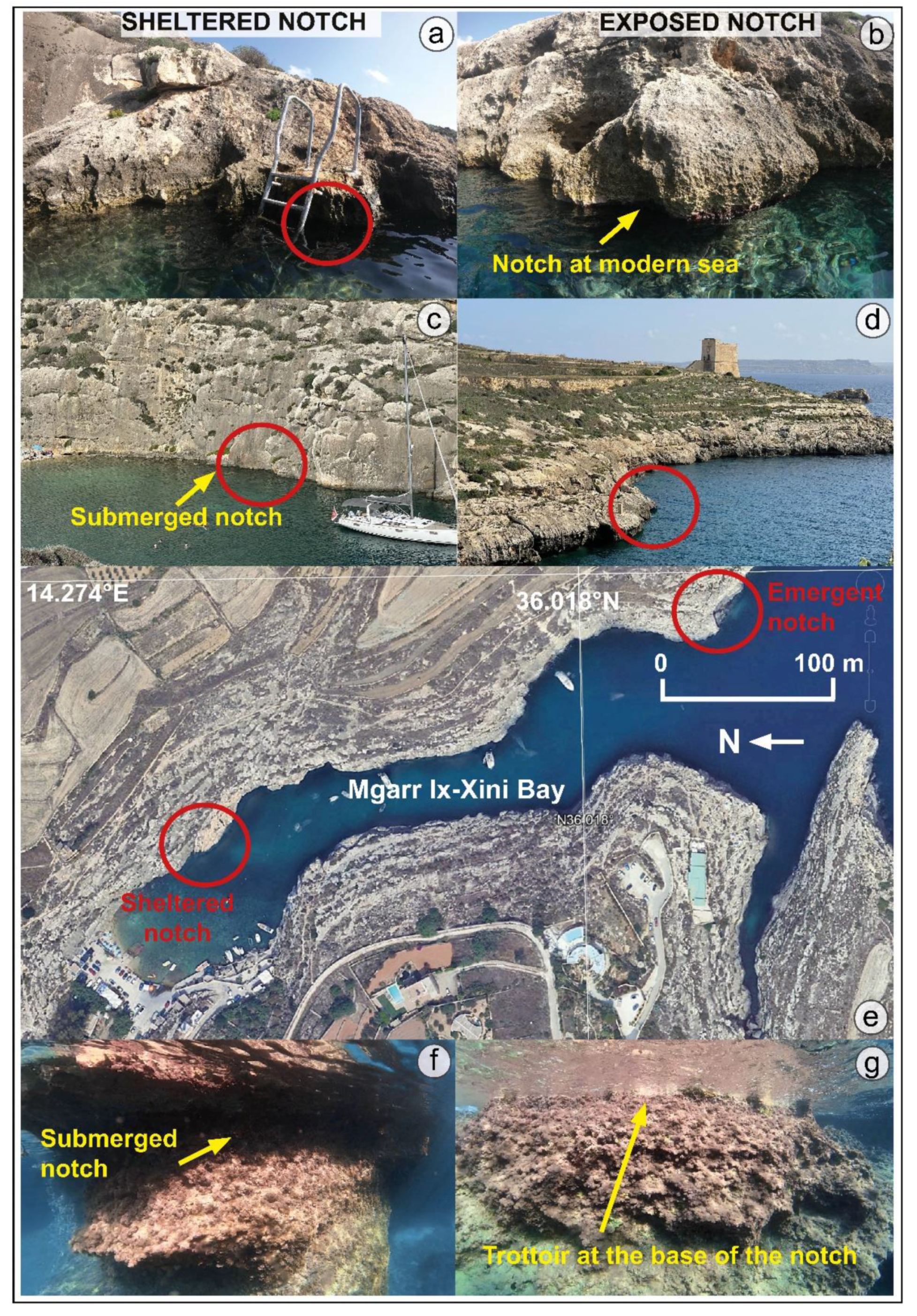
Figure 9.
The southern side of the Mgarr-Ix-Xini bay: a) 3D model of the entire southern sector. The waterline shows where the notch is emerged and submerged; b) zoom of the sheltered sector of the bay with the dipped notch; c) zoom of the exposed sector of the bay with the dipped notch; d) topographic profiles obtained from the 3D model. On the right, the exposed part of the bay is modelized, while on the left, the sheltered one.
4) Tide gauge data collected in the period from 2021 to 2023 (Figure 5) show that the tide gauge mean sea level is about 0.15 m lower with respect to the biological mean sea level. This was discussed with ISPRA technicians, who informed us that the tide gauge sea level should be raised, so measured DPs sometimes could appear even lower.
5) Regarding the interpretation of the submerged notch at the Friul Archipelago provided by [33], the authors wrote: “At the sheltered sites, the relative absence of mechanical wave action and bio-erosion (intrinsically correlated) were not conducive to the formation of the notch in the last millennium. The absence of these major erosional processes also influenced the shape of the notch, which, in contrast to the exposed site notch, presents both the roof and the floor. The floor has probably been preserved due to the increase of sea level rise rates in the last millennium, which significantly lowered the erosion rates observed in the previous ~400 years of relative sea-level stability”. Our opinion follows the interpretation provided by Antonioli et al.[2], for which the formation of MTN follow sea level rise. The submerged notch described in Vacchi et al.[33] (Fig 2e in the paper) could represent the Holocene STN by Antonioli et al.[31] (see Figure 2a), in which sizes are proportional to the local GIA, with lower values in Marseille and significantly higher values in Sardinia and Sicily [41]. Vacchi et al.[33] agreed with us that submerged notches in the Frioul Archipelago only form in sheltered areas, while roof notches in the exposed ones. Their measurements would be correct with respect to the Marseille tide gauge data, even if now they are not available. They attribute the carving of the roof notch to the mechanisms of relative sea level rise already described in [2,42], with a close relation between past sea levels and roof notches. Regarding the submerged notch, they attribute its carving to the fluctuation of the LIA (Little Ice Age), between 1000 and 1500 years BP, as mentioned in [43], when the rates of sea level rise were significantly lower than today (as described in Figure 5 of the paper [33]). The authors also added very low rates, in mm\year, of GIA [44]. Regarding the sheltered sites in the Frioul Islands they write that data are in good agreement with those reported by [45] in the northern Adriatic, where a relict submerged tidal notch formed during the post-Roman sea-level stabilization. So, the roof notch rose with the sea, the submerged one, due to the lack of coralline algae and reef, recorded the small ice age at -35 cm. Then, it stopped forming;
6) tectonics does not play a significant role in the tilting of the notch, first because the study areas are tectonically stable [2,5,46], and second because all the bays shows the same behaviour, but neighbouring bays do not exhibit DTNs.
Starting from our measurements and comparing with data published by [33], we suggest that:
1) the present-day GIA in southern France and Lampedusa are similar, and they range between 0.1 m and 0.2 m;
2) the annual rainfall at Frioul Islands is the same as in the Lampedusa islands;
3) our observations in the Lampedusa and Gozo islands are continuous, so we could observe the elevation of the notch gradually submerging towards the innermost part of the rias, with a total lowering of 0.58 m toward the innermost part of the rias. It is noteworthy that Furlani and Cucchi [47] highlighted that lowering rates increase sligthly below the mean sea level in a sheltered site such as a small harbour in the Gulf of Trieste.
4) Data collected by Furlani et al. [19] during the Geoswim expedition in 2013 in Gozo showed that several submarine springs occur along the island, also during summer periods, and the swim surveyors reported one in the Mgarr Ix-Xini ria. Even if at Cala Madonna was not surveyed during the Geoswim expedition, it could be possible that it was due to low summer precipitation. For the roof notch, the term “visor” has been proposed by Evelpidou et al. [48] which ascribes erosion to dissolution by a freshwater spring undercutting a limestone cliff at sea level. Our data are not in agreement with this genesis for the roof notch because we did not observe the presence of freshwater springs at either the sheltered or exposed sites along the Frioul archipelago.
5) Unlike the sheltered areas described by Vacchi et al. [33], in Cala Madonna and Mgarr IX-Xini, the coralline algae reef at the mean sea level are continuous along the ria cliffs, and they are similar to the exposed sites in which the 'normal' MTN occurs. The biological features of the sites under examination, although coming from geographically distant areas, can probably depend on a well-known set of both abiotic and biotic factors. While in the intertidal zone typical assemblages of encrusting or erect calcareous red algae are often present, in the first subtidal the presence of a barren without algal cover is probably due both to grazing by sea urchins, frequent in the images, and to a differential sedimentation rate. The effects of increased surface temperatures, which appear to have the ability to maintain a barren that has formed biologically through the action of grazer species, and the presence of freshwater should also be assessed.
6. Conclusions
The occurrence of DTNs in southward exposed bays represents a specific phenomenon related to localized sites in the central Mediterranean basin. Considering the observations and measurements carried out at these sites, our tentative hypothesis suggests that a combination of marine factors, influenced by local winds and waves driven by the topography and morphology of the small bays exposed to southern quadrants contributes to the formation of these anomalous notches. These unique features manifest under specific conditions, lowering erosion rates slightly below mean sea level in sheltered areas, challenging conventional notions about tidal notch formation. Considering that TNs are widely used as very precise sea level marker, the description and interpretation of the genesis of DTNs is fundamental for coastal geomorphological studies.
Author Contributions
Conceptualization, S.F., F.A.; methodology, S.F., F.A.; software, S.F., V.V.; validation, S.F., F.A.; investigation, all authors; resources, S.F., G.V.; data curation, S.F., F.A., V.V.; writing—original draft preparation, S.F., F.A., M.A.; writing—review and editing, all authors; visualization, V.V.; supervision, S.F., F.A.;; funding acquisition, S.F., G.V.. All authors have read and agreed to the published version of the manuscript.
Funding
This research was carried out in the frame of the Geoswim programme and was founded by the AMP Isole Pelagie and University of Trieste.
Data Availability Statement
The data presented in this study are available on request from the corresponding author.
Acknowledgments
We are grateful to for field surveys..
Conflicts of Interest
The authors declare no conflict of interest..
Abbreviations
The following abbreviations are used in the manuscript:
DTN Dipping Tidal Notch
MTN Modern Tidal Notch
FTN Fossil Tidal Notch
RN Roof Notch
GIA Glacial Isostatic Adjustment
STN Smoothed Tidal Notch
MIS Marine Isotopic Stage
LIA Little Ice Age
References
- Bates, R.L.; Jackson, J.A. Glossary of Geology. 1987.
- Antonioli, F.; Lo Presti, V.; Rovere, A.; Ferranti, L.; Anzidei, M.; Furlani, S.; Mastronuzzi, G.; Orru, P.E.; Scicchitano, G.; Sannino, G.; Spampinato, C.R.; Pagliarulo, R.; Deiana, G.; de Sabata, E.; Sansò, P.; Vacchi, M.; Vecchio, M. Tidal Notches in Mediterranean Sea: A Comprehensive Analysis. Quat. Sci. Rev. 2015, 119, 66–84. [Google Scholar] [CrossRef]
- Furlani, S. Integrating Observational Targets and Instrumental Data on Rock Coasts through Snorkel Surveys: A Methodological Approach. Mar. Geol. 2020, 425, 106191. [Google Scholar] [CrossRef]
- Furlani, S.; Antonioli, F. The Swim-Survey Archive of the Mediterranean Rocky Coasts: Potentials and Future Perspectives. Geomorphology 2023, 421, 108529. [Google Scholar] [CrossRef]
- Antonioli, F.; Anzidei, M.; Lo Presti, V.; Scicchitano, G.; Spampinato, C.R.; Trainito, E.; Furlani, S. Anomolous Multi-Origin Marine Notch Sites: Three Case Studies in the Central Mediterranean Sea. Quat. Int. 2017, 439, 4–16. [Google Scholar] [CrossRef]
- Grasso, M.; Mazzoldi, G.; Torelli, L. Structural and Stratigraphic Framework of the Tunisian Shelf Surrounding the Islands of Lampione and Lampedusa (Pelagian Sea). Geol. Dev. Sicil.-Tunis. Platf. Rep. Mar. Sci. 1993, 58, 65–70. [Google Scholar]
- Grasso, M.; Pedley, H.M.; Reuther, C.-D. The Geology of the Pelagian Islands and Their Structural Setting Related to the Pantelleria Rift (Central Mediterranean Sea). 1985.
- Grasso, M.; Pedley, H.M. The Sedimentology and Development of Terravecchia Formation Carbonates (Upper Miocene) of North Central Sicily: Possible Eustatic Influence on Facies Development. Sediment. Geol. 1988, 57, 131–149. [Google Scholar] [CrossRef]
- Catalano, R.; Infuso, S.; Sulli, A. The Pelagian Foreland and Its Northward Foredeep. Plio-Pleistocene Structural Evolution. Geol. Dev. Sicil.-Tunis. Platf. UNESCO Rep Mar Sci 1993, 58, 37–42. [Google Scholar]
- Civile, D.; Brancolini, G.; Lodolo, E.; Forlin, E.; Accaino, F.; Zecchin, M.; Brancatelli, G. Morphostructural Setting and Tectonic Evolution of the Central Part of the Sicilian Channel (Central Mediterranean). Lithosphere 2021, 2021, 7866771. [Google Scholar] [CrossRef]
- Stazione Meteorologica - Dati Online - Lampedusa Boa Oceanografica : ENEA Available online:. Available online: https://www.lampedusa.enea.it/dati/boa/meteo/index.php?lang=it (accessed on 29 February 2024).
- ENEA Station for Climate Observations Available online:. Available online: https://www.lampedusa.enea.it/ (accessed on 29 February 2024).
- Said, G.; Schembri, J. 8.17 Malta, 2010, 751-759.
- Pedley, H.M.; House, M.R.; Waugh, B. The Geology of the Pelagian Block: The Maltese Islands. In The Ocean Basins and Margins; Nairn, A.E.M., Kanes, W.H., Stehli, F.G., Eds.; Springer US: Boston, MA, 1978; ISBN 978-1-4684-3039-4. [Google Scholar]
- Furlani, S.; Antonioli, F.; Biolchi, S.; Gambin, T.; Gauci, R.; Lo Presti, V.; Anzidei, M.; Devoto, S.; Palombo, M.; Sulli, A. Holocene Sea Level Change in Malta. Quat. Int. 2013, 288, 146–157. [Google Scholar] [CrossRef]
- Paskoff, R.; Sanlaville, P. Observations Geomorphologiques Sur Les Cotes De L’archipel Maltais. Obs. Geomorphol. SUR COTES Archipel MALTAIS 1978.
- Grove, A.T.; Rackham, O. A: Nature of Mediterranean Europe, 2003.
- Schembri, P.J. Current State of Knowledge of the Maltese Non-Marine Fauna. 2003.
- Furlani, S.; Antonioli, F.; Gambin, T.; Gauci, R.; Ninfo, A.; Zavagno, E.; Micallef, A.; Cucchi, F. Marine Notches in the Maltese Islands (Central Mediterranean Sea). Quat. Int. 2017, 439, 158–168. [Google Scholar] [CrossRef]
- Galdies, C. The Climate of Malta: Statistics, Trends and Analysis 1951-2010, 2011.
- Drago, A. Sea Level Variability and the ‘Milghuba’ Seiche Oscillations in the Northern Coast of Malta, Central Mediterranean. Phys. Chem. Earth Parts ABC 2009, 34, 948–970. [Google Scholar] [CrossRef]
- Lambeck, K.; Bard, E. Sea-Level Change along the French Mediterranean Coast for the Past 30 000 Years. Earth Planet. Sci. Lett. 2000, 175, 203–222. [Google Scholar] [CrossRef]
- Dubar, M.; Innocent, C.; Sivan, O. Radiometric Dating (U/Th) of the Lower Marine Terrace (MIS 5.5) West of Nice (French Riviera): Morphological and Neotectonic Quantitative Implications. Comptes Rendus Geosci. 2008, 340, 723–731. [Google Scholar] [CrossRef]
- Antonioli, F.; Ferranti, L. Geomorfologia Costiera e Subacquea e Considerazioni Paleoclimatiche Sul Settore Compreso Tra S. Maria Navarrese e Punta GoloritzË (Golfo Di Orosei, Sardegna). G. Geol. 1992, 54, 65–89. [Google Scholar]
- Laborel, J.; Morhange, C.; Lafont, R.; Le Campion, J.; Laborel-Deguen, F.; Sartoretto, S. Biological Evidence of Sea-Level Rise during the Last 4500 Years on the Rocky Coasts of Continental Southwestern France and Corsica. Mar. Geol. 1994, 120, 203–223. [Google Scholar] [CrossRef]
- Morhange, C.; Laborel, J.; Hesnard, A. Changes of Relative Sea Level during the Past 5000 Years in the Ancient Harbor of Marseilles, Southern France. Palaeogeogr. Palaeoclimatol. Palaeoecol. 2001, 166, 319–329. [Google Scholar] [CrossRef]
- Morhange, C.; Marriner, N.; Excoffon, P.; Bonnet, S.; Flaux, C.; Zibrowius, H.; Goiran, J.; Amouri, M.E. Relative Sea-Level Changes During Roman Times in the Northwest Mediterranean: The 1st Century A.D. Fish Tank of Forum Julii, Fréjus, France. Geoarchaeology 2013, 28, 363–372. [Google Scholar] [CrossRef]
- Lambeck, K.; Purcell, A. Sea-Level Change in the Mediterranean Sea since the LGM: Model Predictions for Tectonically Stable Areas. Quat. Sci. Rev. 2005, 24, 1969–1988. [Google Scholar] [CrossRef]
- Benac, Č.; Juračić, M.; Bakran-Petricioli, T. Submerged Tidal Notches in the Rijeka Bay NE Adriatic Sea: Indicators of Relative Sea-Level Change and of Recent Tectonic Movements. Mar. Geol. 2004, 212, 21–33. [Google Scholar] [CrossRef]
- Benac, Č.; Juračić, M.; Blašković, I. Tidal Notches in Vinodol Channel and Bakar Bay, NE Adriatic Sea: Indicators of Recent Tectonics. Mar. Geol. 2008, 248, 151–160. [Google Scholar] [CrossRef]
- Antonioli, F.; Ferranti, L.; Kershaw, S. A Glacial Isostatic Adjustment Origin for Double MIS 5.5 and Holocene Marine Notches in the Coastline of Italy. Quat. Int. 2006, 145–146, 19–29. [Google Scholar] [CrossRef]
- Antonioli, F.; Ferranti, L.; Stocchi, P.; Deiana, G.; Lo Presti, V.; Furlani, S.; Marino, C.; Orru, P.; Scicchitano, G.; Trainito, E.; Anzidei, M.; Bonamini, M.; Sansò, P:, Mastronuzzi, G. Morphometry and Elevation of the Last Interglacial Tidal Notches in Tectonically Stable Coasts of the Mediterranean Sea. Earth-Sci. Rev. 2018, 185, 600–623. [Google Scholar] [CrossRef]
- Vacchi, M.; Gatti, G.; Kulling, B.; Morhange, C.; Marriner, N. Climatic Control on the Formation of Marine-Notches in Microtidal Settings: New Data from the Northwestern Mediterranean Sea. Mar. Geol. 2022, 453, 106929. [Google Scholar] [CrossRef]
- Lo Presti, V.; Antonioli, F.; Auriemma, R.; Ronchitelli, A.; Scicchitano, G.; Spampinato, C.R.; Anzidei, M.; Agizza, S.; Benini, A.; Ferranti, L.; Gasparo Morticelli, M.; Giarrusso, C.; Mastronuzzi, G:, Monaco, C. ; Porqueddu, A. Millstone Coastal Quarries of the Mediterranean: A New Class of Sea Level Indicator. Quat. Int. 2014, 332, 126–142. [Google Scholar] [CrossRef]
- Rete Mareografica Nazionale - ISPRA Available online:. Available online: https://www.mareografico.it (accessed on 5 March 2024).
- Furlani, S.; Vaccher, V.; Antonioli, F.; Agate, M.; Biolchi, S.; Boccali, C.; Busetti, A.; Caldareri, F.; Canziani, F.; Chemello, R.; Deguara, J.C.; Dal Bo, E.; Dean, S.; Deiana, G.; de Sabata, E.; Donno, Y.; Gauci, R.; Giaccone, T.; Lo Presti, V.; Montagna, P. Preservation of Modern and MIS 5.5 Erosional Landforms and Biological Structures as Sea Level Markers: A Matter of Luck? Water 2021, 13, 2127. [Google Scholar] [CrossRef]
- Airoldi, L.; Virgilio, M. Responses of Turf-Forming Algae to Spatial Variations in the Deposition of Sediments. Mar. Ecol. Prog. Ser. 1998, 165, 271–282. [Google Scholar] [CrossRef]
- Schembri, P.J.; Deidun, A.; Mallia, A.; Mercieca, L. Rocky Shore Biotic Assemblages of the Maltese Islands (Central Mediterranean): A Conservation Perspective. J. Coast. Res. 2005, 21, 157–166. [Google Scholar] [CrossRef]
- Mourtzas, N.; Kolaiti, E. Shoreline Reconstruction of the Submerged Minoan Harbour Morphology in the Bay of Kato Zakros (Eastern Crete, Greece). J. Archaeol. Sci. Rep. 2017, 12, 684–698. [Google Scholar] [CrossRef]
- Lambeck, K.; Antonioli, F.; Anzidei, M.; Ferranti, L.; Leoni, G.; Scicchitano, G.; Silenzi, S. Sea Level Change along the Italian Coast during the Holocene and Projections for the Future. Quat. Int. 2011, 232, 250–257. [Google Scholar] [CrossRef]
- Furlani, S.; Antonioli, F.; Gambin, T.; Biolchi, S.; Formosa, S.; Lo Presti, V.; Mantovani, M.; Anzidei, M.; Calcagnile, L.; Quarta, G. Submerged Speleothem in Malta Indicates Tectonic Stability throughout the Holocene. The Holocene 2018, 28. [Google Scholar] [CrossRef]
- Marriner, N.; Kaniewski, D.; Pourkerman, M.; Devillers, B. Anthropocene Tipping Point Reverses Long-Term Holocene Cooling of the Mediterranean Sea: A Meta-Analysis of the Basin’s Sea Surface Temperature Records. Earth-Sci. Rev. 2022, 227, 103986. [Google Scholar] [CrossRef]
- Spada, G.; Melini, D. New Estimates of Ongoing Sea Level Change and Land Movements Caused by Glacial Isostatic Adjustment in the Mediterranean Region. Geophys. J. Int. 2022, 229, 984–998. [Google Scholar] [CrossRef]
- Faivre, S.; Bakran-Petricioli, T.; Barešić, J.; Horvatić, D.; Macario, K. Relative Sea-Level Change and Climate Change in the Northeastern Adriatic during the Last 1.5 Ka (Istria, Croatia). Quat. Sci. Rev. 2019, 222, 105909. [Google Scholar] [CrossRef]
- Furlani, S.; Pappalardo, M.; Gómez-Pujol, L.; Chelli, A. The Rock Coast of the Mediterranean and Black Seas. In Geological Society, London, Memoirs; 2014; Vol. 40, pp. 89–122.
- Furlani, S.; Cucchi, F. Downwearing Rates of Vertical Limestone Surfaces in the Intertidal Zone (Gulf of Trieste, Italy). Mar. Geol. 2013, 343, 92–98. [Google Scholar] [CrossRef]
- Evelpidou, N.; Pirazzoli, P.A.; Saliège, J.-F.; Vassilopoulos, A. Submerged Notches and Doline Sediments as Evidence for Holocene Subsidence. Cont. Shelf Res. 2011, 31, 1273–1281. [Google Scholar] [CrossRef]
Figure 1.
Overview of the study area. 1a) the Mediterranean area and the location of the studied sites; 1b) the study site at Lampedusa Island (southern Italy); 1c) the studied site of Mgarr-Ix-Xini in the island of Gozo (Malta); 1d) the site of Cassis (southern France) studied by Antonioli et al. [5]where the first observations of dipping tidal notches were reported.
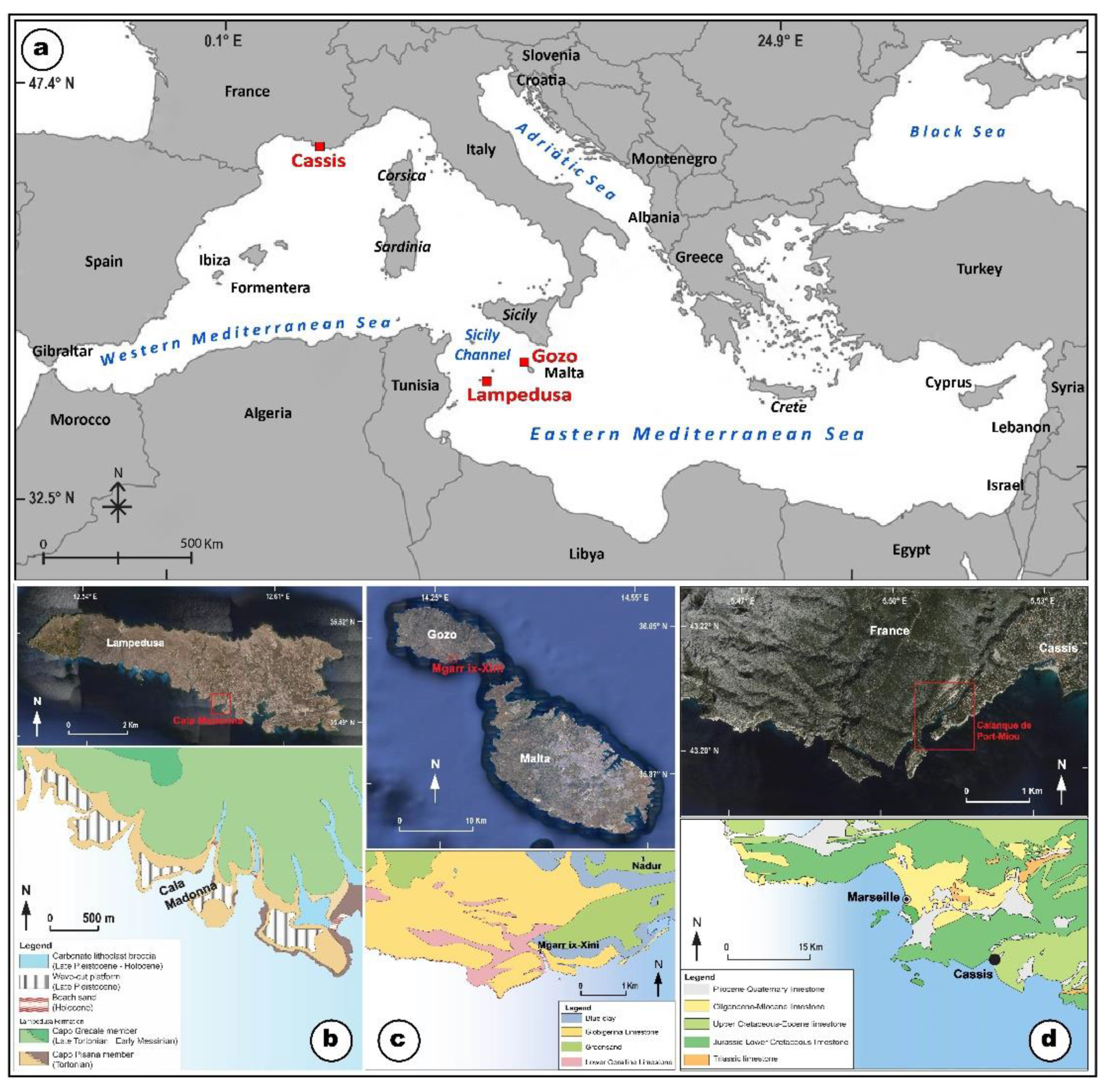
Figure 2.
Sketch of notches described in paragraph 2: a) MTNs and the coupled submerged smoothed notches. Above the FTNs and the coupled fossil smoothed notch; b) roof notch (RN); c) the abrasional notch (AN) at the sea level and below the sea level, and d) dipping notch (DN) as described by [6] from inward to outward.

Figure 3.
Measuring a fossil tidal notch at Capo Caccia (Sardinia, Italy). b: a submerged smoothed notch at Gaeta, Italy. c: a submerged smoothed notch at Capri Island, Italy. d: a submerged smoothed notch at Pan di Zucchero SW Sardinia, Italy. e: a fossil tidal notch into the Grotta dei Cavalli, NW Sicily (Italy). The red arrows indicate the smoothed isostatic notch.

Figure 4.
Tidal notches described by Antonioli et al. [6]; a) the ria of Cassis. Measurements were collected at the end of the harbor within the ria; b) sea cliffs at the mouth of the ria; c) MTN at the mouth of the ria; d) the trottoir with coralline algae at the MTN; e and f) DTN within the Cassis ria.
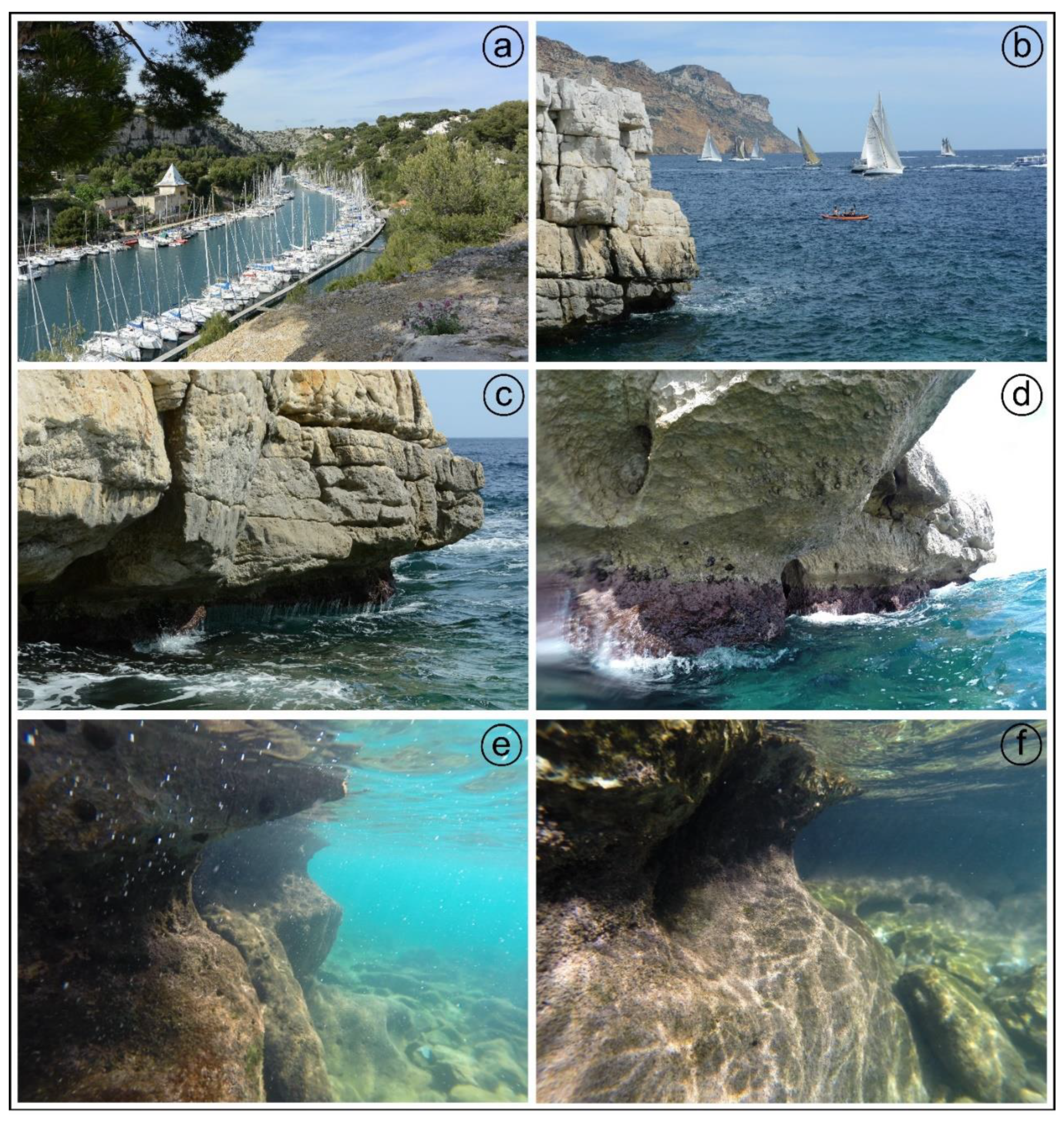

Table 1.
MTN and DTN at the surveyed sites: 1) site number; 2) site name; 3) local coordinates; 4) field measures, or the distance between the mean sea level and the maximum width (roof of the notch); 5) Time of survey; 6) Corrections using local tide gauge data; 7) Corrected altitude of the notch above the altitude corresponding to the maximum width of the tidal notch; 8) width of the tidal notch; 9) average depth at the cliff toe; 10) notch submersion, or the distance between the base of the notch to the corrected mean sea level.
| 1 Site [n] |
2 Site name |
3 Coordinates [deg.dec] |
4 Field measures [m] |
5 Time of survey [h:m] |
6 Tide gauge correction [m] |
7 Corrected altitude over max width [m] |
8 Width of the notch [m] |
9 Depth at the cliff toe [m] |
10 Notch submersion |
|---|---|---|---|---|---|---|---|---|---|
| 1 | Cala Madonna | 35.503027 12.590118 |
-0.50 | 11/25/2022 10:48 |
0.47 | -0.03±0.03 | 0.34 | 1.3 | -0.37±0.03 |
| 2 | Cala Madonna | 35.502467 12.589919 |
-0.30 | 11/25/2022 10:52 |
0.47 | -0.17±0.03 | 0.40 | 1,8 | -0.27±0.03 |
| 3 | Cala Madonna | 35.502026 12.589769 |
+0.10 | 11/25/2022 11:00 |
0.47 | -0.10±0.03 | 0.50 | 2.4 | -0.13±0.03 |
| 4 | Cala Madonna | 35.501623 12.589037 |
+0.8 | 11/25/2022 10:56 |
0.47 | +0.08±0.03 | 0.60 | 3.5 | -0.05±0.03 |
| 5 | Mgarr-Ix-Xini | 36.019931 14.271996 |
-0.50 | 10/28/2022 12:38 |
0 | -0.50 | / | 2.5 | |
| 6 | Mgarr-Ix-Xini | 36.018377 14.272638 |
0.0 | 10/28/2022 12:51 |
0 | 0.0 | / | 4.5 | |
| 7 | Cassis | 43.206497 5.521458 |
-10 | 05/02/2015 14:30 | 0.99 | -0.28 | 0.48 | 1.0 | -0.38 |
| 8 | Cassis | 43. 204071 5. 516312 |
55 | 05-02.2025 15.00 |
-0.99 | 0.45 | 45 | 4.5 | 0 |
Disclaimer/Publisher’s Note: The statements, opinions and data contained in all publications are solely those of the individual author(s) and contributor(s) and not of MDPI and/or the editor(s). MDPI and/or the editor(s) disclaim responsibility for any injury to people or property resulting from any ideas, methods, instructions or products referred to in the content. |
© 2024 by the authors. Licensee MDPI, Basel, Switzerland. This article is an open access article distributed under the terms and conditions of the Creative Commons Attribution (CC BY) license (http://creativecommons.org/licenses/by/4.0/).
Copyright: This open access article is published under a Creative Commons CC BY 4.0 license, which permit the free download, distribution, and reuse, provided that the author and preprint are cited in any reuse.


