Submitted:
26 March 2024
Posted:
26 March 2024
You are already at the latest version
Abstract
In recent decades, as eutrophication in inland and coastal waters (ICWs) has increased due to anthropogenic activities and global warming, so has the need for timely monitoring. Compared with traditional sampling and laboratory analysis methods, satellite remote sensing technology can provide macro-scale, low-cost, and near real-time water quality monitoring services. The Geostationary Ocean Color Imager (GOCI), integrated onboard the Communication Ocean and Meteorological Satellite (COMS) from the Republic of Korea, was the first geostationary ocean color observation satellite and was operational from April 1, 2011 to March 31, 2021. Over ten years, GOCI has observed oceans, coastal waters, and inland waters within its 2,500 km×2,500 km target area centered on the Korean Peninsula. The most attractive feature of GOCI, compared with other commonly used watercolor sensors, was its high temporal resolution (1h, eight times daily from 0 UTC to 7 UTC), providing the opportunity to monitor the quality of ICWs, where optical properties can change rapidly throughout the day. This systematic review aims to comprehensively review GOCI features and applications in ICWs, analyzing progress in atmospheric correction algorithms and water quality monitoring. Analyzing 123 articles from the Web of Science and China National Knowledge Infrastructure (CNKI) through a bibliometric quantitative approach, we examined GOCI’s strength and performance with different processing methods. These articles reveal that GOCI played an essential role in monitoring the ecological health of ICWs in its observation area in East Asia. GOCI has led the way to a new era of geostationary ocean satellites, providing new technical means for monitoring water quality in oceans, coastal zones, and inland lakes. We also discuss the challenges encountered by geostationary satellites in monitoring water quality and provide suggestions for improvements.
Keywords:
GOCI
; inland and coastal waters
; atmospheric correction
; algal blooms
; water quality parameters
1. Introduction
Earth's surface water accounts for about 74% of the global area. Water is an important carrier and critical factor in studying the energy exchange of surface materials[1,2]. For research convenience in watercolor remote sensing, the Earth's water is usually divided into Case-I and Case-II waters based on the optical properties of water[3,4,5]. The optical properties of Case I waters (open oceans) are mainly determined by phytoplankton. Case II waters, including inland and coastal waters (denoted as ICWs; all abbreviations or symbols in this study are shown in Table 1 and Table S1), are optical complexes determined by phytoplankton, detritus, and colored dissolved organic matter (CDOM)[6,7]. Most of the Earth's population lives near ICWs, making them the most economically and socially active regions on Earth. Large amounts of nutrients and pollutants discharged by humans enter some ICWs worldwide, destroying their ecological balance. Damaged waterbodies will, in turn, threaten human health and lead to economic losses[8,9,10,11,12,13]. Remote sensing can complement traditional methods by targeting optically active substance concentrations in monitoring water quality. With the growing number of watercolor satellite sensors launched in recent decades, numerous algorithms have been proposed to retrieve water quality parameters from satellite images to monitor ICWs.
Remote sensing of watercolor from space began in 1978 with the successful launch of the Coastal Zone Color Scanner (CZCS) by the National Aeronautics and Space Administration (NASA)[14]. CZCS, an experimental radiometer intended to operate for only one year, had six bands ranging from visible to near-infrared (NIR). CZCS provided valuable experience for subsequent watercolor satellite development [15,16,17]. After ten years, several watercolor sensors were launched, including the Maritime Observation Satellite (MOS), Ocean Color and Temperature Scanner (OCTS), and Polarization and Directionality of the Earth’s Reflectances (POLDER) in 1996 and the Sea-viewing Wide Field-of-view Sensor (SeaWiFS) in 1997. SeaWiFS was the first watercolor sensor that could provide continuous data on the bio-optical properties (i.e., those properties of organisms that can be visually recorded) of the oceans[18,19,20]. In 1999, the United States successfully launched the Moderate Resolution Imaging Spectroradiometer (MODIS) on the Terra satellite, the first advanced polar-orbiting environmental remote-sensing satellite with nine specific watercolor bands from 412 to 865 nm. MODIS also had three shortwave infrared (SWIR) bands (1240, 1640, and 2130 nm), which have very low reflectance due to the high absorption of pure water[21,22]. The SWIR-based atmospheric correction (AC) method is critical for obtaining reliable and high-accuracy remote sensing reflectance products of highly turbid ICWs. In 2002, the MODIS sensor on the Aqua satellite was launched and began to observe the Earth along with MODIS from Terra (Terra in the morning, Aqua in the afternoon), providing continuous watercolor observations. MODIS has been the most critical watercolor satellite of the past two decades [23,24,25,26,27,28]. The Visible Infrared Imaging Radiometer (VIIRS) extends and enhances the AVHRR and MODIS observation series with six watercolor wavelengths. The three VIIRS sensors (Suomi-NPP, NOAA-20, and NOAA-21) were launched in 2011, 2017, and 2022, respectively. Since VIIRS has spectral bands similar to MODIS, the water quality parameters that MODIS can extract or derive can also be directly monitored by VIIRS. VIIRS can provide watercolor products for highly turbid ICWs, improving the observations capabilities of MODIS, whose watercolor bands tend to saturate[29,30,31,32,33,34]. In December 2018, the United States launched SeaHawk-1, a CubeSat fitted with a low-cost, miniature ocean color sensor called HawkEye that enables fine spatial resolution observations of the ocean[35].
The Medium Resolution Imaging Spectrometer Instrument (MERIS) is a sensor deployed in March of 2002 onboard the polar-orbiting Envisat-1 environmental research satellite by the European Space Agency (ESA). The most significant advantage of MERIS is its various watercolor band selections (fifteen bands from 412 to 900 nm). For example, the 620 nm band of MERIS allows to estimate cyanobacteria biomass in ICWs by targeting characteristic pigments (phycocyanin (PC)) [36,37,38]. The Sentinel-3 OLCI instrument is based on ENVISAT MERIS's opto-mechanical and imaging design and was launched in 2016 (S3A) and 2018 (S3B). OLCI presents many improvements compared with MERIS, such as an increase in the number of spectral bands (from 15 to 21), mitigation of sun-glint contamination by tilting cameras in the westerly direction, and increased coverage of the global ocean (<4 days), land (<3 days with one satellite, ignoring the effect of clouds), compare to MERIS, which was approximately 15 days[39,40,41,42].
In addition to the United States and the European Union, other countries, such as Japan, China, India, and South Korea, have also released satellites with watercolor bands. Japan launched the ocean color satellite Advanced Earth Observation Satellite (ADEOS) in 1996. ADEOS had twelve bands in the wavelength range of 400-900 nm with a spatial resolution of 700 m[43,44,45]. Japan launched the ADEOS-II satellite with the Generation Global Imager (GLI) sensor, with thirty-three bands in the 375-12500 nm wavelength range in 2002. Among these thirty-three bands, six had a spatial resolution of 250 m. The Second Generation Global Imager (SGLI) satellite is an Earth observation satellite developed by the Japan Aerospace Exploration Agency (JAXA) and launched in 2017. SGLI can observe 19 bands of radiation from ultraviolet (UV) to thermal infrared region (380 nm-12 µm). SGLI has two polarization channels (673.5 and 868.5 nm)[46,47,48]. Since 2002, China has launched a series of ocean watercolor satellites, including HY-1A (2002), HY-1B (2007), HY-1C (2018), HY-1D (2022), and HY-1E (2023). The watercolor bands of the early HY satellite series (e.g., HY-1A, HY-1B) are very close to the MODIS watercolor bands. Starting from HY-1C, the HY series satellites have specific watercolor bands (e.g., UV bands). The recently launched HY-1E has two sensors, Chinese Ocean Color and Temperature Scanner 2 (COCTS2) (with eighteen bands and a one-day revisit cycle) and Playful Magnetic Resonance Imaging Simulator (PMRIS) (with nineteen bands and a three-day revisit cycle) [49,50]. India has launched several watercolor satellites, including Oceansat-1 (1996), Oceansat-2 (2009), and Oceansat-3 (2022). The bands have increased from eight (Oceansat-1) to thirteen bands with a spatial resolution of 360 m (Oceansat-3) [51,52,53]. The Ocean Scanning Multispectral Imager (OSMI), mounted on the polar-orbiting satellite Korea Multi-Purpose Satellite-1 (KOMPSAT-1), was launched by South Korea in 1999. OSMI was launched in 2010 and had six bands in the 400-900 nm wavelength range and a spatial resolution of 1km [54,55].
The Geostationary Ocean Color Imager (GOCI) was the world's first geostationary watercolor satellite. It was positioned in a geostationary orbit at approximately 128.2 degrees east longitude, providing continuous monitoring of the oceanic and ICW conditions over the East Asian region. Subsequently, South Korea launched GOCI-II in 2020. GOCI-II has many improvements over GOCI, with more watercolor bands and higher spatial resolution [56,57,58].
Compared with MODIS, VIIRS, or other commonly used watercolor sensors, the most attractive characteristic of GOCI was its high temporal resolution (1h, eight times daily from 0 UTC to 7 UTC), which is important for the accurate monitoring of water quality status, which can change on an hourly or even sub-hourly basis in ICWs [19,59,60,61,62,63]. GOCI was the first sensor with the ability to continuously monitor water quality variations in the ICWs with an hourly temporal resolution. GOCI provided images to monitor the water quality of oceans and ICWs in its target area (about 2,500 km×2,500 km centered on the Korean Peninsula) for nearly ten years, from the first image in 2011 to 2021, when it stopped observations.
Until now, systematic reviews of the research progress and challenges of GOCI applications in ICWs have seldom been documented[64,65,66,67,68,69]. Many countries have launched or plan to launch geostationary watercolor satellites such as GOCI-II and the Geostationary Littoral Imaging and Monitoring Radiometer (GLIMR)[62]. The insights garnered by reviewing GOCI’s functionality have helped design sensors and construct water quality algorithms. This study aims to comprehensively review GOCI, providing information on the configuration parameters of the GOCI sensor, an overview of GOCI, an AC algorithm, ABs monitoring, estimation of water quality parameters (chlorophyll a (Chla), suspended particulate matter (SPM), water clarity and other parameters such as CDOM, particulate organic carbon (POC), dissolved organic carbon (DOC), net primary production (NPP), sea surface salinity (SSS), sea surface currents (SSCs), sea ice, sea fog, lake ice, diffuse attenuation coefficient (), etc.). We also discuss advantages and disadvantages as well as future trends. A diagram of the paper's structure is shown in Figure 1. Before delving into the review, we compare its spatial and temporal resolutions with those of MODIS, Landsat, Sentinel, and other watercolor satellites, highlighting the high observation frequency of GOCI in Table 2.
2. GOCI Overview
The Communication Ocean and Meteorological Satellite (COMS), launched in 2010, is South Korea's first geostationary orbit meteorological satellite and was designed for meteorological services and ocean monitoring research. It was equipped with a new generation of GOCI sensors, which acquired data in eight bands (including six visible light bands and two NIR bands), as shown in Table 3. Its main advantage was to provide satellite observation of the target area eight times daily, from 0 UTC to 7 UTC. Real-time monitoring was centered on South Korea (36°N 130°E) and also encompassed North Korea, Japan, Russia, and China, including the Bohai Sea, the Yellow Sea as well as the East China Sea (Figure 2). The total coverage area was about 2500 km×2500 km [70].
GOCI has fulfilled its mission for nearly a decade by playing a significant role in ICW monitoring. GOCI-II, which succeeded GOCI, was launched in February 2020 and has up to 13 bands (Table 4). Moreover, GOCI-II has a spatial resolution of up to 250 meters, generating ten views of imagery a day (23 UTC to 8 UTC) [71].
3. Bibliometric Analysis
Over the last decade, there has been a surge in research papers on ICWs based on GOCI satellites. Our bibliometric analysis, based on Web of Science queries with "GOCI" and "remote sensing" as keywords, retrieved a total of 164 papers, of which 123 meeting eligibility criteria. The number of publications showed a steady increase, starting from 4 papers published in 2010 to a peak of 13 in 2021 and 2022 (Figure 3 and Table 2). The study area for this article is shown in Figure 4. GOCI has been increasingly used in remote sensing monitoring research of ICWs due to its advantages and development potential. Articles have been published in more than 40 journals, of which 36 in Remote Sensing (RS), followed by 16 in Remote Sensing of the Environment (RSE), 7 in Ocean Science Journal(Ocean Sci J), 6 in Optics EXPRESS (OE), and 4 in the Science of the Total Environment (Sci Total Environ), International Journal of Remote Sensing (Int J Remote Sens), as well as in Environmental Science and Pollution Research (Environ Sci Pollut Res), 3 in Sensors, ISPRS Journal of Photogrammetry and Remote Sensing (ISPRS) and IEEE TRANSACTIONS ON GEOSCIENCE AND REMOTE SENSING (IEEE T-GRS) (Figure 5).
Using “GOCI”, “remote sensing,” and “inland and coastal waters” as the subject terms in the “Web of Science” search, retrieved a total of 1546 eligible authors from the core collection. A Vosviewer statistical analysis of keywords using "author name" formed a keyword map (Figure 6). The authors with the highest number of occurrences were Kim, Jhoon, Ryu, and Joo-hyung, totaling 36 occurrences. The highest number of citations was 1090. Recognizing the significant contributions of Chinese scholars, we extended our search to China National Knowledge Infrastructure (CNKI), merging the search of Chinese and English papers to obtain a clearer picture of the application of GOCI. A total of 746 documents were retrieved through CNKI with GOCI as the keyword, of which 323 were classified and analyzed according to the "subject". Figure 7 shows that most research was on SPM with 40 publications, with Chla in second place with 36 papers, followed by estimation studies (31 articles).
In summary, it can be seen that awareness about GOCI satellites is increasing annually, and their application in various fields is becoming increasingly extensive. In the past decade, the application of GOCI in ICWs has become more and more comprehensive. We found that the highest number of studies on Chla concentration estimation by scholars was 23, followed by SPM concentration estimation (22) and ABs (17), while there were 13 and 10 studies on AC and water clarity, respectively.
4. Inland and Coastal Waters Monitoring by GOCI
This section reviews the capabilities of GOCI. We first provide an overview of AC algorithms. We compare the advantages and disadvantages of different methods and their applicability. Secondly, we highlight the research progress of scholars on AB monitoring. Finally, the estimation of water quality parameters is reviewed and divided into four aspects: Chla, SPM, water clarity, and other water quality parameters.
4.1. Atmospheric Correction over Inland and Coastal Waters
AC is the process of obtaining the reflectance from the top of the atmosphere as observed by satellites. This process is vital because the is the primary input for most water-quality remote sensing algorithms [72,73,74]. The GOCI Data Processing System (GDPS) is the official data processing software for GOCI. The standard AC algorithm of GOCI evolved initially based on the algorithms of SeaWiFS and MODIS, then expanded and improved according to the characteristics of GOCI's own instrument design and research fields [70,75,76,77,78]. This model followed a regional empirical relationship between the and two NIR bands (and ) (denoted as SR660). Aerosol properties from neighboring non-turbid waters were also incorporated to finalize the AC process[75]. [79] improved the SR660 model by introducing two AC models. The first AC model used to replace the , taking advantage of the lower contribution of the absorption signal of non-pure water constituents in. SR709 has been shown to perform well in waters with only one sediment type. The second AC model used the 620 nm radiation (denoted as SRIOP) to estimate the in the NIR bands. SRIOP showed good performance in waters with a variety of sediment types.
Another software, the SeaWiFS Data Analysis System (SeaDAS), provides an AC module to GOCI, including the Management Unit of the North Sea Mathematical Models (MUMM) algorithm, which is used to produce products for the turbid Hangzhou Bay and Yellow River Estuary. MUMM assumes that the magnitude of at 745 and 865 nm is dominated by the backscattering of particles. The ratio of and is assumed to be constant. As aerosol types do not usually vary over spatial scales of about 100 km, the ratio of aerosol reflectance in these two bands can also be regarded as a constant. However, this assumption of is deemed to be invalid for highly turbid waters. Therefore, [80], [81], and [17] used a 2nd order polynomial relationship to parametrize and for the AC of GOCI in highly turbid waters.
The Polymer software also offers a GOCI AC module. However, it is seldom used for GOCI, even though it has been shown to perform well in turbid coastal waters when applied to satellites like MODIS and OLCI.For extremely turbid waters, such as in parts of Changjiang Estuary, Huanghe Estuary, and Hangzhou Bay, where the SPM can be greater than 500 mg L-1, researchers have proposed innovative AC algorithms for GOCI. [82] proposed an improved GOCI AC algorithm for the Changjiang (Yangtze) estuary and the adjacent coast. This approach, based on a spectral optimization algorithm (ESOA) with a coupled water-atmosphere model, employed the simple semi-empirical radiative transfer (SERT) model to parameterize based on the SPM concentrations and the aerosol models proposed by [56]. SeaDAS was used to calculate the contributions in aerosols, and the genetic algorithm optimized the ESOA AC process. For highly turbid waters, the in the UV band may be much less than in the NIR band, enabling the UV band’s use in estimating aerosol scattering. [83] applied the UV-AC algorithm to the GOCI by using the 412 nm band as the UV band to produce. The retrieved aerosol or apparent optical properties products of other satellite sensors can also be used to help GOCI obtain the products.
Many researchers have also developed AC methods for GOCI under non-ideal observation conditions. [84] proposed a novel AC algorithm based on deep learning (denoted as DLACC) to improve the quality of data contaminated by cloud edge effects, including stray light, cloud shadows, and cloud adjacent effects. The observation characteristics of GOCI images from morning to evening also determine that many images have a larger solar zenith angle (SZA) (>70°). It has been reported that a high SZA will increase the residual errors in satellite products due to several factors (e.g., high atmospheric multiple scattering effects and underestimation of the Rayleigh scattering contribution). [85] proposed a new neural network (NN) AC algorithm for GOCI data with a high SZA that retrieves directly from Rayleigh-corrected radiance (). This NN AC algorithm can retrieve in the morning or evening when NIR and KOSC algorithms fail.
4.2. Algal Blooms
ICWs, due to their high population density, are prone to ABs when certain meteorological conditions arise [86,87,88,89,90,91,92,93]. The impact of ABs, such as the reduction in dissolved oxygen and the release of toxins, presents major challenges to aquatic ecosystem management [9,94,95,96]. Monitoring ABs is essential for improving water quality and the inhabitants' quality of life and reducing unnecessary losses. A variety of strategies have been developed to monitor and understand algal blooms, integrating satellite data, modeling, and machine learning techniques for improved accuracy and efficiency[97].
As presented in Section 4.1, most existing AC algorithms do not apply to the pixels affected by harmful algal blooms (HABs) or red tides [79,98,99,100,101].[102] developed PUK, a red tide quantification algorithm for GOCI that does not require an independent AC process, incorporating a radiative transfer simulation combined with a machine-learning technique. Other approaches for extracting the red tide area from the GOCI include the linear mixed model (LMM) and the normalized difference vegetation index (NDVI) threshold method[103]. Also, an improved Red Tide Index (RI) was established by [67] using normalized data at 443, 490, and 555 nm to monitor red tide changes dynamically in East Lake. Additionally, [104] proposed a newly developed normalized red tide index (NRTI) (calculated with Equations (1)–(4)), utilizing a spectroradiometer to observe the spectral characteristics of red tides and seawater in real-time.
Lagrangian particle tracking experiments allow us to understand the paths of floating green algae patches and explain the physical forcing factors that affect the distribution and advection of floating green algae. Using a combination of GOCI data and numerical simulations helped track and monitor extensive areas in the Yellow Sea and East China Sea[105]. Furthermore, [106] developed the Index of floating Green Algae for GOCI (IGAG) (Equation (5)) using multispectral band ratios of three wavelengths (555, 660, and 745 nm) in the Yellow Sea and East China Sea.
A U-net model for the extraction of long-term spatial variations of ABs along the East China Sea was developed using GOCI and was trained on two different datasets –six-band channels (all visible bands) and RGB-band channels (443, 555, and 680 nm) [107]. [108] used a Multi-Layer Perceptron (MLP) machine learning algorithm to establish a novel automatic method to continuously monitor ABs in the Yellow Sea. The method consists of two MLP models, which consider both spectral and spatial features of maps. Accuracy assessment and performance comparison showed that the proposed method has the capability to provide highly accurate prediction maps of macroalgal blooms (F1-score approaching 90% or more) with more robustness than the traditional methods. A novel subpixel-level area estimation method for green algae blooms based on spectral unmixing can detect the existence of green algae and determine their proportion in each pixel. A fast endmember extraction method was proposed to calculate the endmember spectral matrix and the abundance map of green algae automatically, which outperformed existing techniques in experiments on GOCI data [109,110]. [111] used an algal index algorithm to quantify equivalent surface algae density (, 0–100%) at pixel and synoptic scales from each cloud-free image and offered an analysis of diurnal changing patterns of . [112] and [113] used the alternative floating algae index (AFAI) (Equations (6) and (7)):
where the subscripts refer to bands (= 660 nm, = 745 nm, and = 865nm). A classification method was then devised to classify the daily change patterns of ABs automatically into four types to monitor the daily dynamics in Lake Taihu. [114] used the cyanobacterial bloom intensity (CBI) index (Equation (8)), combined with meteorological factors, water stability, and nutrient factors, to monitor hourly changes in cyanobacterial blooms in Lake Taihu:
[110] developed a new floating algae cover (FAC) model following a logistic curve and applied it to China's two large shallow eutrophic lakes, Lake Taihu and Lake Chaohu.
4.3. Water Quality Parameters
The estimation of water quality parameters involves the use of and the underwater irradiance ratio to estimate Chla concentration, SPM concentration, and yellow substances content by calculating the absorption coefficient of phytoplankton, the absorption coefficient of yellow substances, the absorption coefficient of non-pigmented SPM, and the backscattering coefficient () of SPM[65,115,116]. Most commonly, empirical or semi-empirical and artificial intelligence models have been used [117,118,119,120,121]. This section mainly introduces Chla in Section 4.3.1, SPM in Section 4.3.2, water clarity in Section 4.3.3, and then briefly introduces other water quality parameters such as CDOM, POC, DOC, NPP, SSS, SSCs, sea ice, sea fog, lake ice, , among others, in Section 4.3.4.
4.3.1. Chla
The concentration of Chla, which is the most prevalent pigment in algae and relates to phytoplankton biomass[97,122,123,124,125,126,127].Chla concentration is a key indicator of water quality and aquatic ecological health [128,129,130].
The GOCI official process software suggests using the empirical ocean Chla algorithm (OC3G) for GOCI using the 443, 490, and 555 bands (Equation (9))[131]:
where R is calculated as:
and the values of , , , are 0.0831, -1.9941, 0.5629, 0.2944, and -0.5458, respectively.
Various studies have explored alternative models and algorithms for Chla estimation in ICWs. [94] explored the physical-biological interaction between anticyclonic mesoscale eddies and Chla secondary blooms after spring blooms in the East Sea and Japan Sea using the GOCI OC3G Chla products. [132] found diurnal changes in GOCI-derived Chla, with generally higher values in the afternoon than in the morning, and identified heterogeneities in the temporal and spatial domains. [133] applied the Linear Combination Index (LCI) algorithm to GOCI to map Chla distribution in Tachibana Bay, Japan, and found OC3G to have relatively large uncertainties in turbid ICWs. [134] developed MFNN, a neural algorithm that can classify the pixels of GOCI images into three Chla concentration categories (normal, abnormally high, and abnormally low) so that outliers can be identified and provide quality control of GOCI Chla products.
A spectral index method, such as the fluorescence line height (FLH)[135], helped construct a band conversion relationship from 681 to 685 nm to establish a phytoplankton retrieval model suitable for GOCI. [68] calibrated three empirical spectral index algorithms (OC4, OC5, and Yellow and East China Sea Ocean Color (YOC)) and constructed four machine learning algorithms (BP neural network (BPNN), random forest (RF), AdaBoost, and support vector regression (SVR)) using numerous in situ data collected in the Bohai Sea and Yellow Sea. The comparison illustrated that machine learning methods were more accurate than classic spectral index algorithms and that RF performed best. The waters in Hangzhou Bay were classified into moderately and extremely turbid based on the ratio of [136]. Then, the OC3G and modified synthetic chlorophyll index (SCI) index were used for these two water types to map Chla distribution in this bay [136]. [97] modified the generalized algal bloom index algorithm (GABI) to map Chla in the turbid Changjiang Estuary. For this water region, the modified GABI algorithm showed better accuracy and stability than the two-band ratio, three-band, and four-band spectral algorithms.
Lake Taihu is a favorite research area for GOCI Chla model construction and application in inland waters. [137] proposed a weighted algorithm to estimate Chla concentrations based on spectral classification and weighted matching using normalized mutual information (NMI). [138] proposed a regional NIR red ratio algorithm () for Chla retrieval in Lake Taihu. Based on this model, the hourly Chla maps of Lake Taihu were produced from August 6 to August 9, 2013. In this paper, the GOCI-derived Chla products revealed clear evidence of hourly spatial and temporal variations of Chla in the eutrophic inland waters. The was also used by [115] to analyze the spatio-temporal dynamics of Chla and their response to river flow in the estuary of Lake Taihu. [139] proposed a three-band model using the GOCI 681, 745, and 865 nm bands. [140] proposed another three-band Chla model () for GOCI. Simulated and in situ data illustrated that the three-band model outperformed the two-band model under various SPM conditions. [141] proposed a bio-optical hyperspectral reconstruction (BBHR) algorithm to generate simulated hyperspectral ranging in wavelengths from 400 to 800 nm from GOCI and five widely used watercolor sensors. Simulated hyperspectral facilitate the construction of more accurate Chla estimation models for optically complex turbid inland waters. [142] compared the performance of different Chla algorithms for GOCI and GOCI-II in Lake Taihu, Lake Chaohu, and Lake Hongze with as input. The results indicated that the RF algorithm outperformed the commonly used spectral index models.
4.3.2. SPM
SPM refers to the substances suspended in a water body and can be used to characterize its cleanliness [9,143,144,145,146]. The main sources of SPM are surface runoff, sediment resuspension, and organic debris composed of decaying organisms and excrements[147]. SPM directly affects the propagation of light in the water body, which in turn affects the aquatic ecological environment and ultimately determines the primary productivity of the lake[20,148,149,150].
The initial GOCI SPM standard product was based on the algorithm proposed by [151] and [152] as Equation (11):
[153] applied the SPM model proposed by [154] to GOCI as Equation (12) for comparison with the first official SPM algorithm above:
where equals to 1755 and equals 0.198. This paper found that GOCI data can be used to qualitatively study SPM dynamics except in the extremely turbid waters, which are masked out of the GOCI official products. The following standard GOCI SPM was retrieved by the YOC algorithm based on Siswanto's SPM retrieval model for the Yellow and East China Sea (as Equation (13)) [155,156,157]:
He, Bai, Pan, Huang, Dong, Chen, Chen and Cui [83] developed a two-band ratio SPM algorithm () for Hangzhou Bay and nearby coastal waters. The diurnal variations derived by GOCI showed a good relationship with the buoy data in the region. Yu [158] proposed an experiential SPM algorithm suitable for the Bohai Sea and Yellow Sea to evaluate the effects of typhoons on SPM by carrying out parameter optimization and genetic programming, as with Equation (14):
Also, using this model, [159] studied dynamic variations of SPM in China's macro-tidal Yalu River estuary. [160] and [161] developed a single-red band model () to retrieve SPM on the west coast of the Korean Peninsula and Bohai Sea. [149] developed an empirical SPM retrieval algorithm based on the spectral absorption index (SAI) in highly turbid Hangzhou Bay with Equations (15) and (16):
[119] developed a two-step SPM retrieval model using in situ simulated GOCI and SPM data collected in Lake Taihu, Lake Chaohu, Lake Dianchi, and the Three Gorges Reservoir. Firstly, a clustering method was applied to classify the turbid inland waters into three types (Type 1, Type 2, and Type 3). Secondly, the best performing of the three SPM algorithms was gauged and determined by comparison of their results (Type 1: , Type 2: , and Type 3: ). Similarly, [138] proposed another classification-based SPM inversion algorithm in Lake Taihu. The waters were classified into two types based on the index calculated with Equation (17):
For the waters with 0.005, the two-band ratio (Equation (18)) was used, and for the waters with 0.005, the three-band algorithm (Equation (19)) was used:
[115] proposed a single NIR band algorithm () to retrieve SPM in the estuary of northwest Lake Taihu. [162] developed a semi-analytical SPM model for estimating SPM using the satellite-in situ matchup data collected in Lake Taihu and Hangzhou Bay. [163] calibrated the SPM model proposed by [83] to map SPM products using GOCI in Lake Taihu as Equation (20):
The GOCI-derived SPM products are consistent with a two-dimensional model that couples shallow water and SPM transport dynamics. The high-spatial-resolution GOCI SPM product combined with the hydrodynamic model has essential application value in high-time frequency suspended solids transport monitoring. [146] developed a quadratic polynomial model of one variable () to map SPM in Lake Taihu (Equation (21)):
From the hourly GOCI-derived SPM products, they found that the Tiaoxi River greatly influenced the spatial distributions of SPM in Lake Taihu by the plumes after heavy precipitation events. [148] developed a multivariate linear stepwise regression method for retrieval of the surface horizontal distribution of SPM using GOCI. Then, the estimation model of the vertical structure of underwater SPM was constructed using layer-by-layer recursion. These efforts retrieved the horizontal and vertical distribution of SPM concentration from GOCI data over Lake Hongze.
4.3.3. Water Clarity
Water clarity is a critical parameter for the optical properties of ICWs[146,164,165,166,167], vital for characterizing the turbidity and absorption/scattering of light by water bodies. It directly relates to the inherent optical properties of waterbodies, such as Chla, SPM, and phytoplankton biomass [168,169,170,171,172,173].
To estimate water clarity using GOCI data, [173] proposed a regional linear corrected Secchi disk depth (SDD) model based on the mechanical model developed by [174] (denoted as ). This model uses the GOCI derived by the MUMM in Jiaozhou Bay, and its formulation is given in Equation (22):
where is the minimum in the visible bands (412, 443, 490, 555, 660, and 680 nm), while is the corresponding to the waveband with the minimum value. The model considers factors like SZA, tides, and wind force to control diurnal variations. [175] validated the suitability of using in situ products and SDD in Jiaozhou Bay and Qingdao coastal areas. [176] compared the retrieved SDD by different atmospheric correction products and doubted the previous conclusions regarding the hourly variations of biochemical parameters using GOCI, finding them inconsistent. [169] found that the retrieved SDD by was underestimated for their in situ data collected in the Bohai Sea and Yellow Sea due to the uncertainties in the estimation of in in turbid waters. They replaced the original estimation method using a weighted proposed by [177] combined by two estimation methods (one for clear and one for turbid water) and a weighted coefficient. [178] used the GOCI-derived Chla and SPM products to calculate and and then input them into the semi-analytical model proposed by [179] and [180] (denoted as ) to retrieve SDD in the eastern China seas with Equation (23):
Many studies have shown that is biased in estimating SDD in inland waters[168,181]. [168] used a linear relationship to correct (denoted as ) and applied this algorithm to GOCI in Lake Taihu with as Equation (24):
[182] proposed an improved Quasi-Analytical Algorithm (QAA)-estimated SDD algorithm (denoted as ) for GOCI using in situ data collected in Lake Taihu, Lake Hongze, Lake Dongting, and Lake Erhai. firstly estimated using QAA with an assumption of the pure water absorption () is dominated at this band (). was estimated using Equation (25):
where represents the SZA. [182] found that the is at 555 nm in Lake Taihu and Lake Hongze. Thus, a linear relationship was built to convert to :
The retrieved was used to retrieve SDD using Equation (22).
4.3.4. Other Parameters
In addition to the above main water quality parameters, scholars have also conducted research on CDOM, POC, DOC, NPP, SSS, SSCs, sea ice, sea fog, lake ice, , and other parameters. CDOM is the main constituent of dissolved organic matter (DOM) and a key indicator of water quality conditions[183,184,185]. Based on QAA and QAA_CDOM, [186] developed a new algorithm named QAA_cj to estimate CDOM concentration. The algorithm can easily be applied to high turbidity coastal waters. A simple approach to estimate the CDOM concentration was also proposed based on the datasets derived from in situ measurements during four cruise surveys over the Bohai Sea and Yellow Sea. Eight band combination forms (using Xi as a delegate, where i denotes the numerical order of band combination forms), including single bands, band ratios, and other band combinations by were trained to test the correlations with the CDOM concentrations [187]. POC is an essential form of water carbon, taking part in various biogeochemical processes and influencing both organic and inorganic carbon cycles [188,189,190,191]. A remote sensing algorithm that can monitor and accurately estimate the changes in POC fluxes in real-time at the Yangtze Estuary hydrological station was established using GOCI satellite data [192,193]. DOC refers to various dissolved organic molecules ubiquitous in aquatic systems. It is a dynamic reduced carbon pool with important ecological and geochemical functions in inland and coastal waters [194,195]. A regional, red-blue ratio algorithm was proposed to estimate Lake Taihu's surface DOC and analyze its spatiotemporal variation characteristics[196]. Accurate assessments of spatial and temporal changes of NPP in the euphotic zone are critical to understanding the role of the ocean in regulating Earth's climate and assessing future fisheries production, as well as predicting the impacts of ocean warming, hypoxia, and ocean acidification on marine ecosystems [197,198,199]. [199] used the Adsorption Based Productivity Model (Abpm) to monitor diurnal and daily surface and euphotic-column integrated NPP. Global changes of SSS can simulate and predict changes in exchanges between the atmosphere and the ocean surface, as well as the ocean surface and the deep sea. SSS is also involved in the intensification of the global water cycle. For the estimation of SSS, a multi-layer perceptron neural network (MPNN) was employed to train the nonlinear processes of GOCI-II spectral measurements as inputs and the SSS of Soil Moisture Active Passive (SMAP) as the target [102]. SSCs are one of the most important physical properties in ocean dynamics and are crucial for understanding ocean physical and biogeochemical processes [69,200,201]. A method based on maximum cross-correlation (MCC) was used to derive changes in SSCs in the highly turbid waters of Hangzhou Bay to capture better tidal phase variations [77]. Sea ice monitoring is vital for marine traffic, fisheries, ports, and weather forecasting. A simple method to monitor the sea ice area (SIA) and separate it from seawater was proposed, employing standard deviation filtering to enhance the spatial variability between sea ice and open water [202]. In addition, the accurate detection of sea ice thickness (SIT) is crucial for understanding climate change and preventing sea ice disasters. [203] proposed a SIT inversion method for Liaodong Bay based on Rayleigh scattering corrected reflectance, which has practical advantages in estimation accuracy and spatiotemporal resolution. This method can also be applied to the global ocean. Also, an object-based feature extraction method and an albedo-based thickness inversion model were used for estimating SIA and SIT, respectively, by [204] to reach a better effect. The emergence of sea fog leads to low visibility and seriously threatens the safety of maritime activities. Therefore, monitoring changes in sea fog is particularly important[205]. [206] proposed a method to identify sea fog based on the convolutional neural network transfer learning model (CNN-TL). [205] established a sea fog dataset (SFDD) and a dual-branch sea fog detection network (DB-SFNet). Lake ice is one of the essential climate variables of the cryosphere and is closely related to lake environments, ecological regulation, and the safety of human activities[207,208,209]. [210] used the enhanced spatial and temporal adaptive reflection fusion model (ESTARFM) to merge Landsat and GOCI images and extracted the length and angles of the linear structure to monitor the hourly changes in the surface morphology of Lake Chagan. is an important optical property of water, which describes the penetration of incident solar radiation in the water column. is a quasi-inherent optical property since it depends on the water constituents and the distribution of the ambient light field [211,212,213,214]. An improvement of the parameterization equations in the inverse scheme of the 2Seacolor model was used in the Yangtze Estuary to retrieve [215].
5. Discussions
5.1. Integrating Geostationary Ocean Color Satellites, Unmanned Aerial Vehicles, and Ground Collaborative Observation
Due to cloud interference, it is difficult for GOCI to take advantage of its high temporal resolution characteristics, especially in cloudy and humid areas [216]. With the development of satellite remote sensing technology, unmanned aerial vehicles and ground observation technology are also growing rapidly, as shown in Figure 9. The development of unmanned aerial vehicles includes improved sensors and payloads, enhanced flight control systems, miniaturization, lightweight design, and higher battery life [217,218,219]. Ground observation technology progress includes improving sensors and algorithms, providing more accurate estimates of water quality parameters, and the ability to monitor continuously, long-term, in real-time, and automatically [220,221]. GOCI can be used to produce water-quality products in clear weather. In cloudy weather, unmanned aerial vehicle observation results and point ground observation results for an area of interest can be input into hydrodynamic models to generate a simulated numerical water quality dataset [222,223]. The integration of technology can achieve all-weather water quality monitoring of ICWs.
5.2. Fusion of Geostationary Ocean Color Satellites with Other Satellite Products
Image fusion can combine the advantages of different temporal, spatial, and spectral resolution sensors to improve the monitoring of water quality in ICWs [176,224]. Geostationary meteorological satellites (GMST) tend to have higher temporal resolution than geostationary ocean color satellites (GOCS). For example, Himawari 8/9 acquires data every ten minutes. However, low signal-to-noise ratio and spatial resolution limit the application of GMST in water quality monitoring [225]. With the GOCS as a reference, the spatial resolution of the GMST can be improved, and the spectral information can be enhanced. The fused GMST may produce better water quality products in ICWs than the original images [226]. The schematic diagram of image fusion is shown in Figure 10.
Similarly, fusion can also improve GOCS products. The fusion of GOCS and medium- and high-resolution satellites can improve the spatial resolution of GOCS, providing more spatial details of ICW quality changes [227]. The fusion of GOCS and hyperspectral satellites will enhance the spectrum of GOCS, improving the accuracy of the water quality products of GOCS [228]. In addition to multiple daily observations, GOCS, like GOCI, can provide long-time series observation data. Developing technologies to integrate GOCS products with other long-term series satellite products (SeaWiFS, MODIS, and VIIRS) will contribute to long-term series of water quality assessments [229,230,231,232].
5.3. Improving Spectral, Spatial, and Temporal Resolution of Geostationary Ocean Color Sensors
5.3.1. Improving Spectral Resolution
GOCI was equipped with eight bands (six for visible light and two for NIR). The next generation of GOCI (GOCI-II) increased the number of bands to thirteen (one for UV, eight for visible, three for near-infrared, and one for broad bandwidth). The new 380 nm ultraviolet band can be used to retrieve parameters related to the absorption of CDOM (e.g., DOC, carbon dioxide, or organic pollutants) [117,233]. It also allows for applying ultraviolet AC methods to GOCI to provide more reliable products [66,234]. The 510 nm band can potentially improve the performance of OC3G or other blue-green Chla algorithms in relatively clear ICWs [235]. PC can characterize cyanobacterial biomass, which has a distinct absorption peak at about 620 nm [236,237]. Many inland lakes on the Korean Peninsula and East China have frequent occurrences of cyanobacterial blooms [238,239,240,241]. The newly added 620 nm band allows GOCI-II to monitor cyanobacteria blooms quantitatively. The last new band of GOCI-II is 709 nm. Many studies have illustrated this band’s usefulness in Chla retrievals [242,243]. GOCI-II has the potential to provide more accurate Chla products in turbid ICWs.
The newly added five bands provide many advantages to GOCI-II compared with GOCI. The GLIMR is a geostationary sensor funded by the NASA Earth Venture Instrument program, which is anticipated to launch within this decade (around 2026-2027) [244]. GLIMR is planned to provide 340-1025 nm hyperspectral data of aquatic ecosystems. The hyperspectral characteristic of GLIMR may provide more reliable atmospherically corrected products and more accurate water quality products (e.g., Chla, SPM, or SDD). By targeting absorption or backscatter characteristics at different wavelengths, GLIMR may provide more new water quality parameters (e.g., algae species, oil spills, microplastics, or greenhouse gases). GOCI, GOCI-II, and GLIMR (planned) have only visible and NIR bands. The complex optical properties of ICWs require that products are combined with different AC algorithms based on the bands’ wavelengths (e.g., UV, visible, NIR, and SWIR bands) [245]. The next-generation GOCS should have more band choices.
The observation characteristics of GOCS from morning to afternoon determine that the SZA of many images is relatively large (e.g., >70°), especially in high latitudes regions, in the northern hemisphere winter seasons, or in the early morning or late afternoon observation time. The satellite images with a high SZA will increase the residual errors in satellite-derived products due to many factors (e.g., higher atmospheric multiple scattering effects and underestimation of the Rayleigh contribution) [24,60,72]. A higher spectral signal-to-noise ratio is the prerequisite for constructing effective AC methods under high SZA [60]. The next-generation GOCS should improve spectral resolution through better sensor design.
5.3.2. Improving Spatial Resolution
Most of the applications of GOCI in inland waters have been carried out in Lake Taihu, Lake Hongze, and Lake Chagan. The coarse spatial resolution of 500 m makes it hard to use GOCI to monitor water quality in small lakes. With an improved spatial resolution of 250 m, GOCI-II can monitor more inland waters than GOCI. Inland waters with small sizes are more easily affected by human activities and global warming than large lakes [246,247]. We very much hope to have higher spatial resolution GOCS to serve the water environment health monitoring of small and medium-sized lakes.
5.3.3. Improving Temporal Resolution
The most significant advantage of GOCS is its high temporal resolution. The observation times of GLIMR, GOCI, and GOCI-II are six (planned), eight, and ten per day. Many water quality changes, such as ABs vertical and horizontal movements [248,249], lacustrine greenhouse gas emission fluxes [250], and estuary sediment fluxes [251,252] tend to happen rapidly, at sub-hourly time scales. It is better to improve the temporal resolution of GOCS from hours to minutes when these conditions are met.
6. Conclusions
In this work, we reviewed the applications of GOCI for AC and water quality parameter retrieval in ICWs. First, we introduced the GOCI specifications and compared them with those of other satellites, highlighting the advantages of GOCI in high-temporal water quality monitoring. Then, AC and water quality (such as ABs, Chla, SPM, SDD, or others) algorithms for GOCI were systematically introduced. The results of the bibliometric analysis showed that many papers were published in the last thirteen years, starting in 2010.
A number of AC or water quality retrieval models for GOCI have been proposed over the years. These models form a GOCI algorithm library for monitoring water quality in various ICWs. Due to the complex optical properties of ICWs, it is difficult to identify one best performing model of AC or one specific water quality parameter (ABs, Chla, SPM, SDD, or others), as they differ across ICW waterbodies or even across the seasons in the same waterbody. GOCI provides valuable experience for effectively using GOCS to monitor the water qualities of ICWs. So far, there is still no official GOCI product for water quality monitoring in ICWs. Classifying the ICWs into different water types and retrieving the water quality by the most suitable model for each type may provide an official, reliable, and high-accuracy watercolor product for various ICWs.
We partly summarize and introduce future directions for GOCI and other next-generation GOCS to serve the water quality monitoring of ICWs better. Cloudy weather limits the use of high-temporal GOCS satellites. Integrating GOCS, unmanned aerial vehicles, and ground collaborative observation can achieve all-weather water quality monitoring of ICWs. GMST tends to have higher temporal resolution than GOCS and lower spatial and spectral resolutions. The fusion of GOCS with other GMSTs will improve the spatial and spectral ability of GMST. The fusion of GOCS with other high spatial or spectral sensors will enhance the image quality of GOCS itself to monitor ICWs. We suggest the next generation of GOCSs can improve their spatial, spectral, and temporal resolution to monitor the water quality of ICWs better.
Supplementary Materials
The following supporting information can be downloaded at the website of this paper posted on Preprints.org.
Funding
The research was jointly supported by the National Key Research and Development Program of China (2021YFB3901101), the National Natural Science Foundation of China (No. 42171385, U23A2008), and the Youth Innovation Promotion Association of Chinese Academy of Sciences, China (2022228).
Author Contribution
Conceptualization: Ge Liu, Kaishan Song; Methodology: Shidi Shao, Yu Wang; Data curation: Shidi Shao, Ge Liu; Formal analysis: Shidi Shao, Ge Liu, Yu Wang; Investigation: Shidi Shao, Yu Wang; Writing - original draft: Ge Liu, Kaishan Song; Writing - review & editing: Kaishan Song.
Data Availability Statement
Data availability statement: The GOCI and GOCI-II data that support the findings of this study are openly available at https://oceancolor.gsfc.nasa.gov/cgi/browse.pl?per=MO&day=16892&sub=level3&prm=TC&set=80&ndx=0&mon=16161&sen=goci&rad=0&frc=0&cn=90&cs=-90&cw=-180&ce=180&dnm=D and https://www.nosc.go.kr/eng/program/actionTimeSeries.do.
Conflict of interest
The authors declare that they have no known competing financial interests or personal relationships that could have appeared to influence the work reported in this paper.
References
- Schofield, O.; Arnone, R.A.; Bissett, W.P.; Dickey, T.D.; Davis, C.O.; Finkel, Z.; Oliver, M.; Moline, M.A. Watercolors in the coastal zone: What can we see? 2004.
- Shi, J.; Shen, Q.; Yao, Y.; Zhang, F.; Li, J.; Wang, L. Field Radiometric Calibration of a Micro-Spectrometer Based on Remote Sensing of Plateau Inland Water Colors. Applied Sciences 2023, 13, 2117. [Google Scholar] [CrossRef]
- Morel, A.; Prieur, L. Analysis of variations in ocean color 1. Limnology and oceanography 1977, 22, 709–722. [Google Scholar] [CrossRef]
- Gordon, H.R.; Morel, A.Y. Remote assessment of ocean color for interpretation of satellite visible imagery: A review. 2012.
- Sathyendranath, S. Reports of the International Ocean-Colour Coordinating Group. IOCCG Project Office, Dartmouth, Nova Scotia, IOCCG Rep 2000, 3, 140. [Google Scholar]
- Schroeder, T.; Schaale, M.; Fischer, J. Retrieval of atmospheric and oceanic properties from MERIS measurements: A new Case-2 water processor for BEAM. International Journal of Remote Sensing 2007, 28, 5627–5632. [Google Scholar] [CrossRef]
- Kyryliuk, D.; Kratzer, S. Evaluation of Sentinel-3A OLCI products derived using the Case-2 Regional CoastColour processor over the Baltic Sea. Sensors 2019, 19, 3609. [Google Scholar] [CrossRef] [PubMed]
- Ding, X.; He, X.; Bai, Y.; Zhu, Q.; Gong, F.; Li, H.; Li, J. High-frequency and tidal period observations of suspended particulate matter in coastal waters by AHI/Himawari-8. Opt Express 2020, 28, 27387–27404. [Google Scholar] [CrossRef] [PubMed]
- Li, J.; Li, Y.; Bi, S.; Xu, J.; Guo, F.; Lyu, H.; Dong, X.; Cai, X. Utilization of GOCI data to evaluate the diurnal vertical migration of Microcystis aeruginosa and the underlying driving factors. J Environ Manage 2022, 310, 114734. [Google Scholar] [CrossRef]
- Mouw, C.B.; Greb, S.; Aurin, D.; DiGiacomo, P.M.; Lee, Z.; Twardowski, M.; Binding, C.; Hu, C.; Ma, R.; Moore, T.; et al. Aquatic color radiometry remote sensing of coastal and inland waters: Challenges and recommendations for future satellite missions. Remote Sensing of Environment 2015, 160, 15–30. [Google Scholar] [CrossRef]
- Palmer, S.C.J.; Kutser, T.; Hunter, P.D. Remote sensing of inland waters: Challenges, progress and future directions. Remote Sensing of Environment 2015, 157, 1–8. [Google Scholar] [CrossRef]
- Wang, S.; Zhang, X.; Chen, N.; Tian, L.; Zhang, Y.; Nam, W.H. A systematic review and quantitative meta-analysis of the relationships between driving forces and cyanobacterial blooms at global scale. Environ Res 2023, 216, 114670. [Google Scholar] [CrossRef]
- Zeng, F.; Song, C.; Cao, Z.; Xue, K.; Lu, S.; Chen, T.; Liu, K. Monitoring inland water via Sentinel satellite constellation: A review and perspective. ISPRS Journal of Photogrammetry and Remote Sensing 2023, 204, 340–361. [Google Scholar] [CrossRef]
- Hovis, W.A.; Clark, D.; Anderson, F.; Austin, R.; Wilson, W.; Baker, E.; Ball, D.; Gordon, H.; Mueller, J.; El-Sayed, S. Nimbus-7 Coastal Zone Color Scanner: system description and initial imagery. Science 1980, 210, 60–63. [Google Scholar] [CrossRef] [PubMed]
- Conkright, M.; Gregg, W. Comparison of global chlorophyll climatologies: In situ, CZCS, Blended in situ-CZCS and SeaWiFS. International Journal of Remote Sensing 2003, 24, 969–991. [Google Scholar] [CrossRef]
- Cracknell, A.P. The development of remote sensing in the last 40 years. 2018, 39, 8387–8427.
- Jiang, L.; Wang, M. Improved near-infrared ocean reflectance correction algorithm for satellite ocean color data processing. Opt Express 2014, 22, 21657–21678. [Google Scholar] [CrossRef] [PubMed]
- Pan, Y.; Shen, F.; Wei, X. Fusion of Landsat-8/OLI and GOCI Data for Hourly Mapping of Suspended Particulate Matter at High Spatial Resolution: A Case Study in the Yangtze (Changjiang) Estuary. Remote Sensing 2018, 10. [Google Scholar] [CrossRef]
- Salisbury, J.; Davis, C.; Erb, A.; Hu, C.; Gatebe, C.; Jordan, C.; Lee, Z.; Mannino, A.; Mouw, C.; Schaaf, C.; et al. Coastal Observations from a New Vantage Point. Eos 2016, 97. [Google Scholar] [CrossRef]
- Wu, J.; Chen, C.; Nukapothula, S. Atmospheric Correction of GOCI Using Quasi-Synchronous VIIRS Data in Highly Turbid Coastal Waters. Remote Sensing 2019, 12. [Google Scholar] [CrossRef]
- Wang, M.; Shi, W. The NIR-SWIR combined atmospheric correction approach for MODIS ocean color data processing. Optics express 2007, 15, 15722–15733. [Google Scholar] [CrossRef] [PubMed]
- Shi, W.; Wang, M. Detection of turbid waters and absorbing aerosols for the MODIS ocean color data processing. Remote Sensing of Environment 2007, 110, 149–161. [Google Scholar] [CrossRef]
- Agarwal, N.; Sharma, R.; Thapliyal, P.; Gangwar, R.; Kumar, P.; Kumar, R. Geostationary satellite-based observations for ocean applications. Current Science 2019, 117, 506–515. [Google Scholar] [CrossRef]
- Bailey, S.W.; Werdell, P.J. A multi-sensor approach for the on-orbit validation of ocean color satellite data products. Remote sensing of environment 2006, 102, 12–23. [Google Scholar] [CrossRef]
- Cao, C.; Wang, S.; Li, J.; Zhao, H.; Shen, W.; Xie, Y. MODIS-based monitoring of spatial distribution of trophic status in 144 key lakes and reservoirs of China in summer of 2018. J. Lake Sci 2021, 33, 405–413. [Google Scholar]
- He, M.; He, S.; Zhang, X.; Zhou, F.; Li, P. Assessment of Normalized Water-Leaving Radiance Derived from GOCI Using AERONET-OC Data. Remote Sensing 2021, 13. [Google Scholar] [CrossRef]
- Tan, Z.; Cao, Z.; Shen, M.; Chen, J.; Song, Q.; Duan, H. Remote Estimation of Water Clarity and Suspended Particulate Matter in Qinghai Lake from 2001 to 2020 Using MODIS Images. Remote Sensing 2022, 14. [Google Scholar] [CrossRef]
- Xiong, J.; Lin, C.; Ma, R.; Cao, Z. Remote Sensing Estimation of Lake Total Phosphorus Concentration Based on MODIS: A Case Study of Lake Hongze. Remote Sensing 2019, 11. [Google Scholar] [CrossRef]
- Baldwin, D.; Tschudi, M.; Pacifici, F.; Liu, Y. Validation of Suomi-NPP VIIRS sea ice concentration with very high-resolution satellite and airborne camera imagery. ISPRS Journal of Photogrammetry and Remote Sensing 2017, 130, 122–138. [Google Scholar] [CrossRef]
- Justice, C.O.; Román, M.O.; Csiszar, I.; Vermote, E.F.; Wolfe, R.E.; Hook, S.J.; Friedl, M.; Wang, Z.; Schaaf, C.B.; Miura, T. Land and cryosphere products from Suomi NPP VIIRS: Overview and status. Journal of Geophysical Research: Atmospheres 2013, 118, 9753–9765. [Google Scholar] [CrossRef]
- Lin, L.; Hao, X.; Zhang, B.; Zou, C.-Z.; Cao, C. Assessment of the Reprocessed Suomi NPP VIIRS Enterprise Cloud Mask Product. Remote Sensing 2021, 13. [Google Scholar] [CrossRef]
- Wang, M.; Jiang, L. VIIRS-derived ocean color product using the imaging bands. Remote Sensing of Environment 2018, 206, 275–286. [Google Scholar] [CrossRef]
- Park, M.-S.; Lee, S.; Ahn, J.-H.; Lee, S.-J.; Choi, J.-K.; Ryu, J.-H. Decadal measurements of the first Geostationary Ocean Color Satellite (GOCI) compared with MODIS and VIIRS data. Remote Sensing 2021, 14, 72. [Google Scholar] [CrossRef]
- Xia, L.; Mao, K.; Ma, Y.; Zhao, F.; Jiang, L.; Shen, X.; Qin, Z. An algorithm for retrieving land surface temperatures using VIIRS data in combination with multi-sensors. Sensors (Basel) 2014, 14, 21385–21408. [Google Scholar] [CrossRef] [PubMed]
- Morrison, J.M.; Jeffrey, H.; Gorter, H.; Anderson, P.; Clark, C.; Holmes, A.; Feldman, G.C.; Patt, F.S. SeaHawk: an advanced CubeSat mission for sustained ocean colour monitoring. In Proceedings of the Sensors, Systems, and Next-Generation Satellites XX; 2016; pp. 309–319. [Google Scholar]
- Arino, O.; Gross, D.; Ranera, F.; Leroy, M.; Bicheron, P.; Brockman, C.; Defourny, P.; Vancutsem, C.; Achard, F.; Durieux, L. GlobCover: ESA service for global land cover from MERIS. In Proceedings of the 2007 IEEE international geoscience and remote sensing symposium; 2007; pp. 2412–2415. [Google Scholar]
- Doerffer, R.; Schiller, H. The MERIS Case 2 water algorithm. International Journal of Remote Sensing 2007, 28, 517–535. [Google Scholar] [CrossRef]
- Rast, M.; Bezy, J.; Bruzzi, S. The ESA Medium Resolution Imaging Spectrometer MERIS a review of the instrument and its mission. International Journal of Remote Sensing 1999, 20, 1681–1702. [Google Scholar] [CrossRef]
- Hammond, M.L.; Henson, S.A.; Lamquin, N.; Clerc, S.; Donlon, C. Assessing the Effect of Tandem Phase Sentinel-3 OLCI Sensor Uncertainty on the Estimation of Potential Ocean Chlorophyll-a Trends. Remote Sensing 2020, 12. [Google Scholar] [CrossRef]
- Moses, W.J.; Gitelson, A.A.; Berdnikov, S.; Povazhnyy, V. Estimation of chlorophyll-a concentration in case II waters using MODIS and MERIS data—successes and challenges. Environmental Research Letters 2009, 4. [Google Scholar] [CrossRef]
- Xu, Y.; He, X.; Bai, Y.; Wang, D.; Zhu, Q.; Ding, X. Evaluation of Remote-Sensing Reflectance Products from Multiple Ocean Color Missions in Highly Turbid Water (Hangzhou Bay). Remote Sensing 2021, 13. [Google Scholar] [CrossRef]
- Tilstone, G.H.; Pardo, S.; Dall'Olmo, G.; Brewin, R.J.W.; Nencioli, F.; Dessailly, D.; Kwiatkowska, E.; Casal, T.; Donlon, C. Performance of Ocean Colour Chlorophyll a algorithms for Sentinel-3 OLCI, MODIS-Aqua and Suomi-VIIRS in open-ocean waters of the Atlantic. Remote Sensing of Environment 2021, 260. [Google Scholar] [CrossRef]
- Deuzé, J.; Bréon, F.; Devaux, C.; Goloub, P.; Herman, M.; Lafrance, B.; Maignan, F.; Marchand, A.; Nadal, F.; Perry, G. Remote sensing of aerosols over land surfaces from POLDER-ADEOS-1 polarized measurements. Journal of Geophysical Research: Atmospheres 2001, 106, 4913–4926. [Google Scholar] [CrossRef]
- Leroy, M.; Deuzé, J.; Bréon, F.; Hautecoeur, O.; Herman, M.; Buriez, J.; Tanré, D.; Bouffies, S.; Chazette, P.; Roujean, J.-L. Retrieval of atmospheric properties and surface bidirectional reflectances over land from POLDER/ADEOS. Journal of Geophysical Research: Atmospheres 1997, 102, 17023–17037. [Google Scholar] [CrossRef]
- Shimoda, H. ADEOS overview. IEEE Transactions on Geoscience and Remote Sensing 1999, 37, 1465–1471. [Google Scholar] [CrossRef]
- Kurihara, Y.; Murakami, H.; Ogata, K.; Kachi, M. A quasi-physical sea surface temperature method for the split-window data from the Second-generation Global Imager (SGLI) onboard the Global Change Observation Mission-Climate (GCOM-C) satellite. Remote Sensing of Environment 2021, 257, 112347. [Google Scholar] [CrossRef]
- Matsuoka, A.; Campbell, J.W.; Hooker, S.B.; Steinmetz, F.; Ogata, K.; Hirata, T.; Higa, H.; Kuwahara, V.S.; Isada, T.; Suzuki, K. Performance of JAXA’s SGLI standard ocean color products for oceanic to coastal waters: chlorophyll a concentration and light absorption coefficients of colored dissolved organic matter. Journal of Oceanography 2021, 1–22. [Google Scholar] [CrossRef]
- Tanaka, K.; Okamura, Y.; Mokuno, M.; Amano, T.; Yoshida, J. First year on-orbit calibration activities of SGLI on GCOM-C satellite. In Proceedings of the Earth observing missions and sensors: Development, implementation, and characterization V; 2018; pp. 101–110. [Google Scholar]
- Qu, L.; Liu, M.; Guan, L. Simulation of Thermal Infrared Brightness Temperatures from an Ocean Color and Temperature Scanner Onboard a New Generation Chinese Ocean Color Observation Satellite. Remote Sensing 2023, 15, 5059. [Google Scholar] [CrossRef]
- Heales, C.J.; Lloyd, E. Play simulation for children in magnetic resonance imaging. Journal of Medical Imaging and Radiation Sciences 2022, 53, 10–16. [Google Scholar] [CrossRef] [PubMed]
- Chakraborty, A.; Kumar, R.; Stoffelen, A. Validation of ocean surface winds from the OCEANSAT-2 scatterometer using triple collocation. Remote sensing letters 2013, 4, 84–93. [Google Scholar] [CrossRef]
- Parmar, R.; Arora, R.; Rao, M.V.; Thyagarajan, K. OCEANSAT 2: mission and its applications. In Proceedings of the GEOSS and Next-Generation Sensors and Missions; 2006; pp. 62–73. [Google Scholar]
- Singh, R.; Kumar, P.; Pal, P.K. Assimilation of Oceansat-2-scatterometer-derived surface winds in the weather research and forecasting model. IEEE Transactions on Geoscience and Remote Sensing 2011, 50, 1015–1021. [Google Scholar] [CrossRef]
- Lee, S.-J.; Lee, D.-E.; Choi, S.-Y.; Kwon, O.-S. OSMI-1 enhances TRAIL-induced apoptosis through ER stress and NF-κB signaling in colon cancer cells. International Journal of Molecular Sciences 2021, 22, 11073. [Google Scholar] [CrossRef]
- Hamacher, K.; Buchkremer, R. Measuring online sensory consumer experience: introducing the Online Sensory Marketing Index (OSMI) as a structural modeling approach. Journal of Theoretical and Applied Electronic Commerce Research 2022, 17, 751–772. [Google Scholar] [CrossRef]
- Lamquin, N.; Mazeran, C.; Doxaran, D.; Ryu, J.-H.; Park, Y.-J. Assessment of GOCI radiometric products using MERIS, MODIS and field measurements. Ocean Science Journal 2012, 47, 287–311. [Google Scholar] [CrossRef]
- Shin, J.; Lee, J.-S.; Jang, L.-H.; Lim, J.; Khim, B.-K.; Jo, Y.-H. Sargassum detection using machine learning models: A case study with the first 6 months of GOCI-II imagery. Remote Sensing 2021, 13, 4844. [Google Scholar] [CrossRef]
- Warren, M.; Quartly, G.D.; Shutler, J.; Miller, P.I.; Yoshikawa, Y. Estimation of ocean surface currents from maximum cross correlation applied to GOCI geostationary satellite remote sensing data over the Tsushima (K orea) S traits. Journal of Geophysical Research: Oceans 2016, 121, 6993–7009. [Google Scholar] [CrossRef]
- Paduan, J.D.; Washburn, L. High-frequency radar observations of ocean surface currents. Annual review of marine science 2013, 5, 115–136. [Google Scholar] [CrossRef]
- Ruddick, K.; Neukermans, G.; Vanhellemont, Q.; Jolivet, D. Challenges and opportunities for geostationary ocean colour remote sensing of regional seas: A review of recent results. Remote Sensing of Environment 2014, 146, 63–76. [Google Scholar] [CrossRef]
- Ryu, J.-H.; Han, H.-J.; Cho, S.; Park, Y.-J.; Ahn, Y.-H. Overview of geostationary ocean color imager (GOCI) and GOCI data processing system (GDPS). Ocean Science Journal 2012, 47, 223–233. [Google Scholar] [CrossRef]
- Schaeffer, B.A.; Whitman, P.; Vandermeulen, R.; Hu, C.; Mannino, A.; Salisbury, J.; Efremova, B.; Conmy, R.; Coffer, M.; Salls, W.; et al. Assessing potential of the Geostationary Littoral Imaging and Monitoring Radiometer (GLIMR) for water quality monitoring across the coastal United States. Mar Pollut Bull 2023, 196, 115558. [Google Scholar] [CrossRef]
- Son, S.; Kim, Y.H.; Kwon, J.-I.; Kim, H.-C.; Park, K.-S. Characterization of spatial and temporal variation of suspended sediments in the Yellow and East China Seas using satellite ocean color data. GIScience & Remote Sensing 2014, 51, 212–226. [Google Scholar] [CrossRef]
- Duan, H.; Ma, R.; Hu, C. Evaluation of remote sensing algorithms for cyanobacterial pigment retrievals during spring bloom formation in several lakes of East China. Remote Sensing of Environment 2012, 126, 126–135. [Google Scholar] [CrossRef]
- Li, J.; Gao, M.; Feng, L.; Zhao, H.; Shen, Q.; Zhang, F.; Wang, S.; Zhang, B. Estimation of chlorophyll-a concentrations in a highly turbid eutrophic lake using a classification-based MODIS land-band algorithm. IEEE Journal of Selected Topics in Applied Earth Observations and Remote Sensing 2019, 12, 3769–3783. [Google Scholar] [CrossRef]
- Liu, H.; He, X.; Li, Q.; Kratzer, S.; Wang, J.; Shi, T.; Hu, Z.; Yang, C.; Hu, S.; Zhou, Q. Estimating ultraviolet reflectance from visible bands in ocean colour remote sensing. Remote Sensing of Environment 2021, 258, 112404. [Google Scholar] [CrossRef]
- Lou, X.; Hu, C. Diurnal changes of a harmful algal bloom in the East China Sea: Observations from GOCI. Remote Sensing of Environment 2014, 140, 562–572. [Google Scholar] [CrossRef]
- Wang, J.; Tang, J.; Wang, W.; Wang, Y.; Wang, Z. Quantitative Retrieval of Chlorophyll-a Concentrations in the Bohai–Yellow Sea Using GOCI Surface Reflectance Products. Remote Sensing 2023, 15. [Google Scholar] [CrossRef]
- Yang, H.; Choi, J.K.; Park, Y.J.; Han, H.J.; Ryu, J.H. Application of the Geostationary Ocean Color Imager (GOCI) to estimates of ocean surface currents. Journal of Geophysical Research: Oceans 2014, 119, 3988–4000. [Google Scholar] [CrossRef]
- Li, G.; Wang, L.; Wang, X.; Wang, X.; Sun, G. Geostationary ocean color imager and application progress. Marine environmental science 2014, 33, 966–971. [Google Scholar]
- Yin, W.; Huang, D. Applications of geostationary satellite data in the study of ocean and coastal short-term processes: Two cases in the East China Sea. In Remote Sensing of Ocean and Coastal Environments; Elsevier: 2021; pp. 139–154.
- Chen, J.; He, X.; Quan, W.; Ma, L.; Jia, M.; Pan, D. A statistical analysis of residual errors in satellite remote sensing reflectance data from oligotrophic open oceans. IEEE Transactions on Geoscience and Remote Sensing 2021, 60, 1–12. [Google Scholar] [CrossRef]
- Gong, S.; Huang, J.; Li, Y.; Wang, H. Comparison of atmospheric correction algorithms for TM image in inland waters. International Journal of Remote Sensing 2008, 29, 2199–2210. [Google Scholar] [CrossRef]
- Zeng, Q.; Zhao, Y.; Tian, L.-Q.; Chen, X.-L. Evaluation on the atmospheric correction methods for water color remote sensing by using HJ-1A/1B CCD image-taking Poyang Lake in China as a case. Spectroscopy and Spectral Analysis 2013, 33, 1320–1326. [Google Scholar] [PubMed]
- Ahn, J.-H.; Park, Y.-J.; Ryu, J.-H.; Lee, B.; Oh, I.S. Development of atmospheric correction algorithm for Geostationary Ocean Color Imager (GOCI). Ocean Science Journal 2012, 47, 247–259. [Google Scholar] [CrossRef]
- Concha, J.; Mannino, A.; Franz, B.; Kim, W. Uncertainties in the Geostationary Ocean Color Imager (GOCI) Remote Sensing Reflectance for Assessing Diurnal Variability of Biogeochemical Processes. Remote Sensing 2019, 11. [Google Scholar] [CrossRef]
- Hu, Y.; Dou, T.; Yang, B. A review of research on retrieving the concentration of suspended particulate matter and chlorophyll-a in lake based on GOCI images. Journal of Water Resources & Water Engineering 2017, 28, 26–39. [Google Scholar]
- Huang, X.; Zhu, J.; Han, B.; Jamet, C.; Tian, Z.; Zhao, Y.; Li, J.; Li, T. Evaluation of Four Atmospheric Correction Algorithms for GOCI Images over the Yellow Sea. Remote Sensing 2019, 11. [Google Scholar] [CrossRef]
- Ahn, J.-H.; Park, Y.-J. Estimating Water Reflectance at Near-Infrared Wavelengths for Turbid Water Atmospheric Correction: A Preliminary Study for GOCI-II. Remote Sensing 2020, 12. [Google Scholar] [CrossRef]
- Ahn, J.H.; Park, Y.J.; Kim, W.; Lee, B.; Oh, I.S. Vicarious calibration of the Geostationary Ocean Color Imager. Opt Express 2015, 23, 23236–23258. [Google Scholar] [CrossRef] [PubMed]
- Goyens, C.; Jamet, C.; Ruddick, K.G. Spectral relationships for atmospheric correction. II. Improving NASA's standard and MUMM near infra-red modeling schemes. Opt Express 2013, 21, 21176–21187. [Google Scholar] [CrossRef] [PubMed]
- Pan, Y.; Shen, F.; Verhoef, W. An improved spectral optimization algorithm for atmospheric correction over turbid coastal waters: A case study from the Changjiang (Yangtze) estuary and the adjacent coast. Remote Sensing of Environment 2017, 191, 197–214. [Google Scholar] [CrossRef]
- He, X.; Bai, Y.; Pan, D.; Huang, N.; Dong, X.; Chen, J.; Chen, C.-T.A.; Cui, Q. Using geostationary satellite ocean color data to map the diurnal dynamics of suspended particulate matter in coastal waters. Remote Sensing of Environment 2013, 133, 225–239. [Google Scholar] [CrossRef]
- Men, J.; Feng, L.; Chen, X.; Tian, L. Atmospheric correction under cloud edge effects for Geostationary Ocean Color Imager through deep learning. ISPRS Journal of Photogrammetry and Remote Sensing 2023, 201, 38–53. [Google Scholar] [CrossRef]
- Li, H.; He, X.; Bai, Y.; Shanmugam, P.; Park, Y.-J.; Liu, J.; Zhu, Q.; Gong, F.; Wang, D.; Huang, H. Atmospheric correction of geostationary satellite ocean color data under high solar zenith angles in open oceans. Remote Sensing of Environment 2020, 249. [Google Scholar] [CrossRef]
- An, D.; Yu, D.; Zheng, X.; Zhou, Y.; Meng, L.; Xing, Q. Monitoring the Dissipation of the Floating Green Macroalgae Blooms in the Yellow Sea (2007–2020) on the Basis of Satellite Remote Sensing. Remote Sensing 2021, 13. [Google Scholar] [CrossRef]
- Bing, Z.; Xiaoli, C.; Sen, W.; Xinxin, Y. Analysis of the Causes of Cyanobacteria Bloom: A Review. Journal of Resources and Ecology 2020, 11. [Google Scholar] [CrossRef]
- Blondeau-Patissier, D.; Gower, J.F.R.; Dekker, A.G.; Phinn, S.R.; Brando, V.E. A review of ocean color remote sensing methods and statistical techniques for the detection, mapping and analysis of phytoplankton blooms in coastal and open oceans. Progress in Oceanography 2014, 123, 123–144. [Google Scholar] [CrossRef]
- Cannizzaro, J.P.; Barnes, B.B.; Hu, C.; Corcoran, A.A.; Hubbard, K.A.; Muhlbach, E.; Sharp, W.C.; Brand, L.E.; Kelble, C.R. Remote detection of cyanobacteria blooms in an optically shallow subtropical lagoonal estuary using MODIS data. Remote Sensing of Environment 2019, 231. [Google Scholar] [CrossRef]
- Huan, Y.; Sun, D.; Wang, S.; Zhang, H.; Qiu, Z.; Bilal, M.; He, Y. Remote sensing estimation of phytoplankton absorption associated with size classes in coastal waters. Ecological Indicators 2021, 121. [Google Scholar] [CrossRef]
- Paerl, H.W.; Xu, H.; McCarthy, M.J.; Zhu, G.; Qin, B.; Li, Y.; Gardner, W.S. Controlling harmful cyanobacterial blooms in a hyper-eutrophic lake (Lake Taihu, China): the need for a dual nutrient (N & P) management strategy. Water research 2011, 45, 1973–1983. [Google Scholar]
- Sakib, M.H.; Rashid, A.H.A.; Yang, C.S. Comparing performance of inter-sensor NDVI for the detection of floating macroalgal blooms in the Yellow Sea. 2021.
- Sun, X.; Wu, M.; Xing, Q.; Song, X.; Zhao, D.; Han, Q.; Zhang, G. Spatio-temporal patterns of Ulva prolifera blooms and the corresponding influence on chlorophyll-a concentration in the Southern Yellow Sea, China. Sci Total Environ, 2018; 640-641, 807–820. [Google Scholar] [CrossRef]
- Hong, T.T.M.; Park, Y.-G.; Choi, J.M. Divergence Observation in a Mesoscale Eddy during Chla Bloom Revealed in Submesoscale Satellite Currents. Remote Sensing 2023, 15. [Google Scholar] [CrossRef]
- Noh, J.H.; Kim, W.; Son, S.H.; Ahn, J.H.; Park, Y.J. Remote quantification of Cochlodinium polykrikoides blooms occurring in the East Sea using geostationary ocean color imager (GOCI). Harmful Algae 2018, 73, 129–137. [Google Scholar] [CrossRef]
- Sun, D.; Huan, Y.; Qiu, Z.; Hu, C.; Wang, S.; He, Y. Remote-Sensing Estimation of Phytoplankton Size Classes From GOCI Satellite Measurements in Bohai Sea and Yellow Sea. Journal of Geophysical Research: Oceans 2017, 122, 8309–8325. [Google Scholar] [CrossRef]
- Fan, C.; Zhang, Y.; Wang, X. Chlorophyll-a concentration inversion and distribution with GOCI images in the Changjiang Estuary. In Proceedings of the First International Conference on Spatial Atmospheric Marine Environmental Optics (SAME 2023); 2023; pp. 201–210. [Google Scholar]
- Choi, J.-K.; Min, J.-E.; Noh, J.H.; Han, T.-H.; Yoon, S.; Park, Y.J.; Moon, J.-E.; Ahn, J.-H.; Ahn, S.M.; Park, J.-H. Harmful algal bloom (HAB) in the East Sea identified by the Geostationary Ocean Color Imager (GOCI). Harmful Algae 2014, 39, 295–302. [Google Scholar] [CrossRef]
- Shen, F.; Tang, R.; Sun, X.; Liu, D. Simple methods for satellite identification of algal blooms and species using 10-year time series data from the East China Sea. Remote Sensing of Environment 2019, 235. [Google Scholar] [CrossRef]
- Xu, M.; Gao, Z.; Liu, C. Detecting harmful algal blooms using Geostationary Ocean Color Imager (GOCI) data in Bohai Sea, China. In Proceedings of the Remote Sensing and Modeling of Ecosystems for Sustainability XII; 2015; pp. 203–208. [Google Scholar]
- Yimin, L.; Zhenyu, T.; Chen, Y.; Feng, H.; Di, M.; Juhua, L.; Hongtao, D. Extraction of Algal Blooms in Dianchi Lake Based on Multi-Source Satellites Using Machine Learning Algorithms. Advances in Earth Science 2022, 37, 1141. [Google Scholar]
- Kim, D.-W.; Kim, S.-H.; Baek, J.-Y.; Lee, J.-S.; Jo, Y.-H. GOCI-II based sea surface salinity estimation using machine learning for the first-year summer. International Journal of Remote Sensing 2022, 43, 6605–6623. [Google Scholar] [CrossRef]
- Cao, H.; Han, L. Hourly remote sensing monitoring of harmful algal blooms (HABs) in Taihu Lake based on GOCI images. Environ Sci Pollut Res Int 2021, 28, 35958–35970. [Google Scholar] [CrossRef] [PubMed]
- Lee, M.-S.; Park, K.-A.; Micheli, F. Derivation of Red Tide Index and Density Using Geostationary Ocean Color Imager (GOCI) Data. Remote Sensing 2021, 13. [Google Scholar] [CrossRef]
- Son, Y.B.; Choi, B.-J.; Kim, Y.H.; Park, Y.-G. Tracing floating green algae blooms in the Yellow Sea and the East China Sea using GOCI satellite data and Lagrangian transport simulations. Remote Sensing of Environment 2015, 156, 21–33. [Google Scholar] [CrossRef]
- Son, Y.B.; Min, J.-E.; Ryu, J.-H. Detecting massive green algae (Ulva prolifera) blooms in the Yellow Sea and East China Sea using geostationary ocean color imager (GOCI) data. Ocean Science Journal 2012, 47, 359–375. [Google Scholar] [CrossRef]
- Feng, C.; Wang, S.; Li, Z. Long-term spatial variation of algal blooms extracted using the U-net model from 10 years of GOCI imagery in the East China Sea. Journal of Environmental Management 2022, 321, 115966. [Google Scholar] [CrossRef] [PubMed]
- Qiu, Z.; Li, Z.; Bilal, M.; Wang, S.; Sun, D.; Chen, Y. Automatic method to monitor floating macroalgae blooms based on multilayer perceptron: case study of Yellow Sea using GOCI images. Opt Express 2018, 26, 26810–26829. [Google Scholar] [CrossRef] [PubMed]
- Pan, B.; Shi, Z.; An, Z.; Jiang, Z.; Ma, Y. A novel spectral-unmixing-based green algae area estimation method for GOCI data. IEEE Journal of Selected Topics in Applied Earth Observations and Remote Sensing 2016, 10, 437–449. [Google Scholar] [CrossRef]
- Xue, K.; Ma, R.; Cao, Z.; Shen, M.; Hu, M.; Xiong, J. Monitoring fractional floating algae cover over eutrophic lakes using multisensor satellite images: MODIS, VIIRS, GOCI, and OLCI. IEEE Transactions on Geoscience and Remote Sensing 2022, 60, 1–15. [Google Scholar] [CrossRef]
- Qi, L.; Hu, C.; Visser, P.M.; Ma, R. Diurnal changes of cyanobacteria blooms in Taihu Lake as derived from GOCI observations. Limnology and Oceanography 2018, 63, 1711–1726. [Google Scholar] [CrossRef]
- Ai, Y.; Lee, S.; Lee, J. Drinking water treatment residuals from cyanobacteria bloom-affected areas: Investigation of potential impact on agricultural land application. Sci Total Environ 2020, 706, 135756. [Google Scholar] [CrossRef]
- Wang, S.; Zhang, X.; Chen, N.; Wang, W. Classifying diurnal changes of cyanobacterial blooms in Lake Taihu to identify hot patterns, seasons and hotspots based on hourly GOCI observations. J Environ Manage 2022, 310, 114782. [Google Scholar] [CrossRef] [PubMed]
- Li, J.; Li, Y.; Dong, X.; Wang, H.; Cai, X.; Zhu, Y.; Lyu, H.; Zeng, S.; Bi, S.; Wang, G. Contributions of meteorology and nutrient to the surface cyanobacterial blooms at different timescales in the shallow eutrophic Lake Taihu. Science of The Total Environment 2023, 894, 165064. [Google Scholar] [CrossRef] [PubMed]
- Du, C.; Li, Y.; Wang, Q.; Liu, G.; Zheng, Z.; Mu, M.; Li, Y. Tempo-spatial dynamics of water quality and its response to river flow in estuary of Taihu Lake based on GOCI imagery. Environ Sci Pollut Res Int 2017, 24, 28079–28101. [Google Scholar] [CrossRef] [PubMed]
- Wang, M.; Son, S.; Harding, L.W. Retrieval of diffuse attenuation coefficient in the Chesapeake Bay and turbid ocean regions for satellite ocean color applications. Journal of Geophysical Research: Oceans, 2009; 114. [Google Scholar] [CrossRef]
- Li, J.; Yu, Q.; Tian, Y.Q.; Becker, B.L. Remote sensing estimation of colored dissolved organic matter (CDOM) in optically shallow waters. ISPRS Journal of Photogrammetry and Remote Sensing 2017, 128, 98–110. [Google Scholar] [CrossRef]
- Lin, S.; Jing, C.; Rui, L. A method of water quality analysis: chlorophyll a concentration estimation of Dongping Lake based on GOCI image. Environmental Protection 2017, 45, 60–63. [Google Scholar]
- Lyu, H.; Zhang, J.; Zha, G.; Wang, Q.; Li, Y. Developing a two-step retrieval method for estimating total suspended solid concentration in Chinese turbid inland lakes using Geostationary Ocean Colour Imager (GOCI) imagery. International Journal of Remote Sensing 2015, 36, 1385–1405. [Google Scholar] [CrossRef]
- Sagan, V.; Peterson, K.T.; Maimaitijiang, M.; Sidike, P.; Sloan, J.; Greeling, B.A.; Maalouf, S.; Adams, C. Monitoring inland water quality using remote sensing: potential and limitations of spectral indices, bio-optical simulations, machine learning, and cloud computing. Earth-Science Reviews, 2020; 205. [Google Scholar] [CrossRef]
- Qing, S.; Cui, T.; Lai, Q.; Bao, Y.; Diao, R.; Yue, Y.; Hao, Y. Improving remote sensing retrieval of water clarity in complex coastal and inland waters with modified absorption estimation and optical water classification using Sentinel-2 MSI. International Journal of Applied Earth Observation and Geoinformation 2021, 102. [Google Scholar] [CrossRef]
- Bao, Y.; Tian, Q.; Chen, M.; Lü, C. Analysis on Diurnal Variation of Chlorophyll-a Concentration of Taihu Lake Based on Optical Classification with GOCI Data. Guang pu xue yu Guang pu fen xi= Guang pu 2016, 36, 2562–2567. [Google Scholar]
- Cui, T.W.; Zhang, J.; Wang, K.; Wei, J.W.; Mu, B.; Ma, Y.; Zhu, J.H.; Liu, R.J.; Chen, X.Y. Remote sensing of chlorophyll a concentration in turbid coastal waters based on a global optical water classification system. ISPRS Journal of Photogrammetry and Remote Sensing 2020, 163, 187–201. [Google Scholar] [CrossRef]
- Hu, M.; Zhang, Y.; Ma, R.; Xue, K.; Cao, Z.; Chu, Q.; Jing, Y. Optimized remote sensing estimation of the lake algal biomass by considering the vertically heterogeneous chlorophyll distribution: Study case in Lake Chaohu of China. Sci Total Environ 2021, 771, 144811. [Google Scholar] [CrossRef]
- Kim, W.; Moon, J.-E.; Park, Y.-J.; Ishizaka, J. Evaluation of chlorophyll retrievals from Geostationary Ocean Color Imager (GOCI) for the North-East Asian region. Remote Sensing of Environment 2016, 184, 482–495. [Google Scholar] [CrossRef]
- Neil, C.; Spyrakos, E.; Hunter, P.D.; Tyler, A.N. A global approach for chlorophyll-a retrieval across optically complex inland waters based on optical water types. Remote Sensing of Environment 2019, 229, 159–178. [Google Scholar] [CrossRef]
- Soomets, T.; Toming, K.; Paavel, B.; Kutser, T. Evaluation of remote sensing and modeled chlorophyll-a products of the Baltic Sea. Journal of Applied Remote Sensing 2022, 16, 046516–046516. [Google Scholar] [CrossRef]
- Cao, Z.; Wang, M.; Ma, R.; Zhang, Y.; Duan, H.; Jiang, L.; Xue, K.; Xiong, J.; Hu, M. A decade-long chlorophyll-a data record in lakes across China from VIIRS observations. Remote Sensing of Environment 2024, 301, 113953. [Google Scholar] [CrossRef]
- Park, J.-E.; Park, K.-A. Application of Deep Learning for Speckle Removal in GOCI Chlorophyll-a Concentration Images (2012–2017). Remote Sensing 2021, 13. [Google Scholar] [CrossRef]
- Shi, K.; Li, Y.; Li, L.; Lu, H.; Song, K.; Liu, Z.; Xu, Y.; Li, Z. Remote chlorophyll-a estimates for inland waters based on a cluster-based classification. Sci Total Environ 2013, 444, 1–15. [Google Scholar] [CrossRef] [PubMed]
- Li, H.; He, X.; Bai, Y.; Chen, X.; Gong, F.; Zhu, Q.; Hu, Z. Assessment of satellite-based chlorophyll-a retrieval algorithms for high solar zenith angle conditions. Journal of Applied Remote Sensing 2017, 11, 012004–012004. [Google Scholar] [CrossRef]
- Zhao, D.; Feng, L. Assessment of the Number of Valid Observations and Diurnal Changes in Chl-a for GOCI: Highlights for Geostationary Ocean Color Missions. Sensors 2020, 20, 3377. [Google Scholar] [CrossRef] [PubMed]
- Sakuno, Y.; Makio, K.; Koike, K. Chlorophyll-a Estimation in Tachibana Bay by Data Fusion of GOCI and MODIS Using Linear Combination Index Algorithm. Advances in Remote Sensing 2013, 2013. [Google Scholar] [CrossRef]
- Park, J.-E.; Park, K.-A. Application of deep learning for speckle removal in goci chlorophyll-a concentration images (2012–2017). Remote Sensing 2021, 13, 585. [Google Scholar] [CrossRef]
- Zhao, M.; Bai, Y.; Li, H.; He, X.; Gong, F.; Li, T. Fluorescence Line Height Extraction Algorithm for the Geostationary Ocean Color Imager. Remote Sensing 2022, 14, 2511. [Google Scholar] [CrossRef]
- Yang, Y.; He, S.; Gu, Y.; Zhu, C.; Wang, L.; Ma, X.; Li, P. Retrieval of Chlorophyll a Concentration Using GOCI Data in Sediment-Laden Turbid Waters of Hangzhou Bay and Adjacent Coastal Waters. Journal of Marine Science and Engineering 2023, 11, 1098. [Google Scholar] [CrossRef]
- Bao, Y.; Tian, Q.; Chen, M. A Weighted Algorithm Based on Normalized Mutual Information for Estimating the Chlorophyll-a Concentration in Inland Waters Using Geostationary Ocean Color Imager (GOCI) Data. Remote Sensing 2015, 7, 11731–11752. [Google Scholar] [CrossRef]
- Huang, C.; Shi, K.; Yang, H.; Li, Y.; Zhu, A.x.; Sun, D.; Xu, L.; Zou, J.; Chen, X. Satellite observation of hourly dynamic characteristics of algae with Geostationary Ocean Color Imager (GOCI) data in Lake Taihu. Remote Sensing of Environment 2015, 159, 278–287. [Google Scholar] [CrossRef]
- Duan, H.; Ma, R.; Zhang, Y.; Loiselle, S.A.; Xu, J.; Zhao, C.; Zhou, L.; Shang, L. A new three-band algorithm for estimating chlorophyll concentrations in turbid inland lakes. Environmental Research Letters 2010, 5, 044009. [Google Scholar] [CrossRef]
- Guo, Y.; Huang, C.; Li, Y.; Du, C.; Li, Y.; Chen, W.; Shi, L.; Ji, G. an expanded three band model to monitor inland optically complex water using Geostationary Ocean Color Imager (GOCI). Frontiers in Remote Sensing 2022, 3, 803884. [Google Scholar] [CrossRef]
- Yulong, G.; Changchun, H.; Yunmei, L.; Chenggong, D.; Lingfei, S.; Yuan, L.; Weiqiang, C.; Hejie, W.; Enxiang, C.; Guangxing, J. Hyperspectral reconstruction method for optically complex inland waters based on bio-optical model and sparse representing. Remote Sensing of Environment 2022, 276. [Google Scholar] [CrossRef]
- Guo, Y.; Wei, X.; Huang, Z.; Li, H.; Ma, R.; Cao, Z.; Shen, M.; Xue, K. Retrievals of Chlorophyll-a from GOCI and GOCI-II Data in Optically Complex Lakes. Remote Sensing 2023, 15. [Google Scholar] [CrossRef]
- Binding, C.E.; Bowers, D.G.; Mitchelson-Jacob, E.G. Estimating suspended sediment concentrations from ocean colour measurements in moderately turbid waters; the impact of variable particle scattering properties. Remote Sensing of Environment 2005, 94, 373–383. [Google Scholar] [CrossRef]
- Cao, Z.; Ma, R.; Duan, H.; Xue, K.; Shen, M. Effect of Satellite Temporal Resolution on Long-Term Suspended Particulate Matter in Inland Lakes. Remote Sensing 2019, 11. [Google Scholar] [CrossRef]
- Kang, Y.; Dong, C. Spatio-temporal Analysis of suspended sediment Concentration in the Yongjiang Estuary Based on GOCI. In Proceedings of the IOP Conference Series: Earth and Environmental Science; 2018; p. 032017. [Google Scholar]
- Xu, Y.; Qin, B.; Zhu, G.; Zhang, Y.; Shi, K.; Li, Y.; Shi, Y.; Chen, L. High Temporal Resolution Monitoring of Suspended Matter Changes from GOCI Measurements in Lake Taihu. Remote Sensing 2019, 11. [Google Scholar] [CrossRef]
- Jiang, D.; Zhang, H.; Zou, T.; Li, Y.; Tang, C.; Li, R. Suspended particle size retrieval based on geostationary ocean color imager (GOCI) in the Bohai Sea. Journal of Coastal Research 2016, 117–125. [Google Scholar] [CrossRef]
- Lei, S.; Xu, J.; Li, Y.; Du, C.; Liu, G.; Zheng, Z.; Xu, Y.; Lyu, H.; Mu, M.; Miao, S.; et al. An approach for retrieval of horizontal and vertical distribution of total suspended matter concentration from GOCI data over Lake Hongze. Sci Total Environ 2020, 700, 134524. [Google Scholar] [CrossRef] [PubMed]
- Liu, J.; Liu, J.; He, X.; Chen, T.; Zhu, F.; Wang, Y.; Hao, Z.; Chen, P. Retrieval of total suspended particulate matter in highly turbid Hangzhou Bay waters based on geostationary ocean color imager. In Proceedings of the Remote Sensing of the Ocean, Sea Ice, Coastal Waters, and Large Water Regions 2017, 2017; pp. 105–111. [Google Scholar]
- Padial, A.A.; Thomaz, S.M. Prediction of the light attenuation coefficient through the Secchi disk depth: empirical modeling in two large Neotropical ecosystems. Limnology 2008, 9, 143–151. [Google Scholar] [CrossRef]
- Ahn, Y.-H.; Moon, J.-E.; Gallegos, S. Development of suspended particulate matter algorithms for ocean color remote sensing. Korean Journal of Remote Sensing 2001, 17, 285–295. [Google Scholar]
- Moon, J.-E.; Ahn, Y.-H.; Ryu, J.-H.; Shanmugam, P. Development of ocean environmental algorithms for Geostationary Ocean Color Imager (GOCI). Korean Journal of Remote Sensing 2010, 26, 189–207. [Google Scholar]
- Ruddick, K.; Vanhellemont, Q.; Yan, J.; Neukermans, G.; Wei, G.; Shang, S. Variability of suspended particulate matter in the Bohai Sea from the geostationary Ocean Color Imager (GOCI). Ocean Science Journal 2012, 47, 331–345. [Google Scholar] [CrossRef]
- Nechad, B.; Ruddick, K.G.; Park, Y. Calibration and validation of a generic multisensor algorithm for mapping of total suspended matter in turbid waters. Remote Sensing of Environment 2010, 114, 854–866. [Google Scholar] [CrossRef]
- Hu, Z.; Pan, D.; He, X.; Bai, Y. Diurnal Variability of Turbidity Fronts Observed by Geostationary Satellite Ocean Color Remote Sensing. Remote Sensing 2016, 8. [Google Scholar] [CrossRef]
- Moon, J.-E.; Park, Y.-J.; Ryu, J.-H.; Choi, J.-K.; Ahn, J.-H.; Min, J.-E.; Son, Y.-B.; Lee, S.-J.; Han, H.-J.; Ahn, Y.-H. Initial validation of GOCI water products against in situ data collected around Korean peninsula for 2010–2011. Ocean Science Journal 2012, 47, 261–277. [Google Scholar] [CrossRef]
- Siswanto, E.; Tang, J.; Yamaguchi, H.; Ahn, Y.-H.; Ishizaka, J.; Yoo, S.; Kim, S.-W.; Kiyomoto, Y.; Yamada, K.; Chiang, C. Empirical ocean-color algorithms to retrieve chlorophyll-a, total suspended matter, and colored dissolved organic matter absorption coefficient in the Yellow and East China Seas. Journal of oceanography 2011, 67, 627–650. [Google Scholar] [CrossRef]
- Yu, X. Retrieval of Suspended Matter Concentration and Reconstruction of Missing Data Based on GOCI in Bohai and Yellow Sea. Ocean University of China 2013.
- Cheng, Z.; Wang, X.H.; Paull, D.; Gao, J. Application of the geostationary ocean color imager to mapping the diurnal and seasonal variability of surface suspended matter in a macro-tidal estuary. Remote Sensing 2016, 8, 244. [Google Scholar] [CrossRef]
- Choi, J.-K.; Park, Y.J.; Lee, B.R.; Eom, J.; Moon, J.-E.; Ryu, J.-H. Application of the Geostationary Ocean Color Imager (GOCI) to mapping the temporal dynamics of coastal water turbidity. Remote Sensing of Environment 2014, 146, 24–35. [Google Scholar] [CrossRef]
- Meng, Q.; Xu, J.; Wang, L.; Chen, Y.; Wang, X. Diurnal Changes Monitoring and Analysis of the Total Suspended Matters in Bohai Sea Using Geostationary Ocean Color Imager. In Proceedings of the IOP Conference Series: Earth and Environmental Science; 2019; p. 012036. [Google Scholar]
- Zhang, M.; Tang, J.; Dong, Q.; Song, Q.; Ding, J. Retrieval of total suspended matter concentration in the Yellow and East China Seas from MODIS imagery. Remote Sensing of Environment 2010, 114, 392–403. [Google Scholar] [CrossRef]
- He, A.; He, X.; Bai, Y.; Zhu, Q.; Gong, F.; Huang, H.; Pan, D. Simulation of Sedimentation in Lake Taihu with Geostationary Satellite Ocean Color Data. Remote Sensing 2019, 11. [Google Scholar] [CrossRef]
- Amin, R.; Shulman, I. Hourly turbidity monitoring using Geostationary Ocean Color Imager fluorescence bands. Journal of Applied Remote Sensing 2015, 9. [Google Scholar] [CrossRef]
- Kukushkin, A.S. Long-term seasonal variability of water transparency in the surface layer of the deep part of the Black Sea. Russian Meteorology and Hydrology 2014, 39, 178–186. [Google Scholar] [CrossRef]
- Wang, S.; Mao, Y.; Zheng, L.; Qiu, Z.; Bilal, M.; Sun, D. Remote sensing of water turbidity in the eastern China seas from geostationary ocean colour imager. International Journal of Remote Sensing 2020, 41, 4080–4101. [Google Scholar] [CrossRef]
- Yan, Z.; Dingfeng, Y.; Xiaoyan, L.; Qian, Y.; Yingying, G. Research on remote sensing retrieval and diurnal variation of Secchi disk, depth of Jiaozhou Bay based on GOCI. Remote Sensing for Natural Resources 2021, 33. [Google Scholar]
- Bai, S.; Gao, J.; Sun, D.; Tian, M. Monitoring Water Transparency in Shallow and Eutrophic Lake Waters Based on GOCI Observations. Remote Sensing 2020, 12. [Google Scholar] [CrossRef]
- Mao, Y.; Wang, S.; Qiu, Z.; Sun, D.; Bilal, M. Variations of transparency derived from GOCI in the Bohai Sea and the Yellow Sea. Optics Express 2018, 26. [Google Scholar] [CrossRef]
- Swift, T.J.; Perez-Losada, J.; Schladow, S.G.; Reuter, J.E.; Jassby, A.D.; Goldman, C.R. Water clarity modeling in Lake Tahoe: Linking suspended matter characteristics to Secchi depth. Aquatic Sciences 2006, 68, 1–15. [Google Scholar] [CrossRef]
- Swan, B.K.; Reifel, K.M.; Tiffany, M.A.; Watts, J.M.; Hurlbert, S.H. Spatial and temporal patterns of transparency and light attenuation in the Salton Sea, California, 1997–1999. Lake and Reservoir Management 2007, 23, 653–662. [Google Scholar] [CrossRef]
- Testa, J.M.; Lyubchich, V.; Zhang, Q. Patterns and Trends in Secchi Disk Depth over Three Decades in the Chesapeake Bay Estuarine Complex. Estuaries and Coasts 2019, 42, 927–943. [Google Scholar] [CrossRef]
- Zhou, Y.; Yu, D.; Cheng, W.; Gai, Y.; Yao, H.; Yang, L.; Pan, S. Monitoring multi-temporal and spatial variations of water transparency in the Jiaozhou Bay using GOCI data. Mar Pollut Bull 2022, 180, 113815. [Google Scholar] [CrossRef] [PubMed]
- Lee, Z.; Shang, S.; Hu, C.; Du, K.; Weidemann, A.; Hou, W.; Lin, J.; Lin, G. Secchi disk depth: A new theory and mechanistic model for underwater visibility. Remote sensing of environment 2015, 169, 139–149. [Google Scholar] [CrossRef]
- Liu, X.-Y.; Hu, J.-W.; Tian, L.; Yu, D.-F.; Gao, H.; Yang, L.; An, D.-Y. Comparative study on transparency retrieved from GOCI under four different atmospheric correction algorithms in Jiaozhou Bay and Qingdao Coastal area. IEEE Journal of Selected Topics in Applied Earth Observations and Remote Sensing 2023. [CrossRef]
- Liu, X.; Wang, M. Global daily gap-free ocean color products from multi-satellite measurements. International Journal of Applied Earth Observation and Geoinformation 2022, 108, 102714. [Google Scholar] [CrossRef]
- Mao, Y.; Qiu, Z.; Sun, D.; Wang, S.; Lu, Y.; Wu, C.; Yue, X.; Ye, Z. A Novel Remote Sensing Algorithm for Estimating Diffuse Attenuation Coefficient in the BohaiSea and Yellow Sea. Guangxi Science 2016, 23, 513–519. [Google Scholar]
- Ding, X.; Gong, F.; Zhu, Q.; Li, J.; Wang, X.; Bai, R.; Xu, Y. Using geostationary satellite ocean color data and superpixel to map the diurnal dynamics of water transparency in the eastern China seas. Ecological Indicators 2022, 142, 109219. [Google Scholar] [CrossRef]
- He, X.; Pan, D.; Mao, Z. Water-transparency (Secchi Depth) monitoring in the China Sea with the SeaWiFS satellite sensor. In Proceedings of the Remote Sensing for Agriculture, Ecosystems, and Hydrology VI; 2004; pp. 112–122. [Google Scholar]
- He, X.; Pan, D.; Bai, Y.; Wang, T.; Chen, C.-T.A.; Zhu, Q.; Hao, Z.; Gong, F. Recent changes of global ocean transparency observed by SeaWiFS. Continental Shelf Research 2017, 143, 159–166. [Google Scholar] [CrossRef]
- Feng, L.; Hou, X.; Zheng, Y. Monitoring and understanding the water transparency changes of fifty large lakes on the Yangtze Plain based on long-term MODIS observations. Remote Sensing of Environment 2019, 221, 675–686. [Google Scholar] [CrossRef]
- Zeng, S.; Lei, S.; Li, Y.; Lyu, H.; Xu, J.; Dong, X.; Wang, R.; Yang, Z.; Li, J. Retrieval of Secchi Disk Depth in Turbid Lakes from GOCI Based on a New Semi-Analytical Algorithm. Remote Sensing 2020, 12. [Google Scholar] [CrossRef]
- Battin, T.J.; Luyssaert, S.; Kaplan, L.A.; Aufdenkampe, A.K.; Richter, A.; Tranvik, L.J. The boundless carbon cycle. Nature Geoscience 2009, 2, 598–600. [Google Scholar] [CrossRef]
- Berggren, M.; Laudon, H.; Jansson, M. Landscape regulation of bacterial growth efficiency in boreal freshwaters. Global Biogeochemical Cycles 2007, 21. [Google Scholar] [CrossRef]
- Min, S.-H.; Park, M.-O.; Kim, S.-W.; Han, I.-S.; Kim, W.; Park, Y.-J. Correlation between SST and CDOM during Summer Coastal Upwelling along the Southeast Coast of Korea. Journal of Coastal Research 2018, 1471–1475. [Google Scholar] [CrossRef]
- Wang, Y.; Shen, F.; Sokoletsky, L.; Sun, X. Validation and Calibration of QAA Algorithm for CDOM Absorption Retrieval in the Changjiang (Yangtze) Estuarine and Coastal Waters. Remote Sensing 2017, 9. [Google Scholar] [CrossRef]
- Ling, Z.; Sun, D.; Wang, S.; Qiu, Z.; Huan, Y.; Mao, Z.; He, Y. Remote sensing estimation of colored dissolved organic matter (CDOM) from GOCI measurements in the Bohai Sea and Yellow Sea. Environ Sci Pollut Res Int 2020, 27, 6872–6885. [Google Scholar] [CrossRef]
- Bai, Y.; Cai, W.J.; He, X.; Zhai, W.; Pan, D.; Dai, M.; Yu, P. A mechanistic semi-analytical method for remotely sensing sea surface pCO2 in river-dominated coastal oceans: A case study from the East China Sea. Journal of Geophysical Research: Oceans 2015, 120, 2331–2349. [Google Scholar] [CrossRef]
- Bauer, J.E.; Cai, W.-J.; Raymond, P.A.; Bianchi, T.S.; Hopkinson, C.S.; Regnier, P.A. The changing carbon cycle of the coastal ocean. Nature 2013, 504, 61–70. [Google Scholar] [CrossRef] [PubMed]
- Liu, D.; Bai, Y.; He, X.; Tao, B.; Pan, D.; Chen, C.-T.A.; Zhang, L.; Xu, Y.; Gong, C. Satellite estimation of particulate organic carbon flux from Changjiang River to the estuary. Remote Sensing of Environment 2019, 223, 307–319. [Google Scholar] [CrossRef]
- Regnier, P.; Friedlingstein, P.; Ciais, P.; Mackenzie, F.T.; Gruber, N.; Janssens, I.A.; Laruelle, G.G.; Lauerwald, R.; Luyssaert, S.; Andersson, A.J. Anthropogenic perturbation of the carbon fluxes from land to ocean. Nature geoscience 2013, 6, 597–607. [Google Scholar] [CrossRef]
- Xu, J.; Lei, S.; Bi, S.; Li, Y.; Lyu, H.; Xu, J.; Xu, X.; Mu, M.; Miao, S.; Zeng, S.; et al. Tracking spatio-temporal dynamics of POC sources in eutrophic lakes by remote sensing. Water Res 2020, 168, 115162. [Google Scholar] [CrossRef] [PubMed]
- Wei, X.; Shen, F.; Pan, Y.; Chen, S.; Sun, X.; Wang, Y. Satellite Observations of the Diurnal Dynamics of Particulate Organic Carbon in Optically Complex Coastal Oceans: The Continental Shelf Seas of China. Journal of Geophysical Research: Oceans 2019, 124, 4710–4726. [Google Scholar] [CrossRef]
- Catalán, N.; Obrador, B.; Alomar, C.; Pretus, J.L. Seasonality and landscape factors drive dissolved organic matter properties in Mediterranean ephemeral washes. Biogeochemistry 2012, 112, 261–274. [Google Scholar] [CrossRef]
- Fichot, C.G.; Tzortziou, M.; Mannino, A. Remote sensing of dissolved organic carbon (DOC) stocks, fluxes and transformations along the land-ocean aquatic continuum: advances, challenges, and opportunities. Earth-Science Reviews, 2023; 242. [Google Scholar] [CrossRef]
- Huang, C.; Yunmei, L.; Liu, G.; Guo, Y.; Yang, H.; Zhu, A.x.; Song, T.; Huang, T.; Zhang, M.; Shi, K. Tracing high time-resolution fluctuations in dissolved organic carbon using satellite and buoy observations: Case study in Lake Taihu, China. International Journal of Applied Earth Observation and Geoinformation 2017, 62, 174–182. [Google Scholar] [CrossRef]
- Gomes, H.d.R.; Xu, Q.; Ishizaka, J.; Carpenter, E.J.; Yager, P.L.; Goes, J.I. The influence of riverine nutrients in niche partitioning of phytoplankton communities–a contrast between the Amazon River Plume and the ChangJiang (Yangtze) River diluted water of the East China Sea. Frontiers in Marine Science 2018, 5, 343. [Google Scholar] [CrossRef]
- Reid, P.C.; Fischer, A.C.; Lewis-Brown, E.; Meredith, M.P.; Sparrow, M.; Andersson, A.J.; Antia, A.; Bates, N.R.; Bathmann, U.; Beaugrand, G. Impacts of the oceans on climate change. Advances in marine biology 2009, 56, 1–150. [Google Scholar]
- Wu, J.; Goes, J.I.; do Rosario Gomes, H.; Lee, Z.; Noh, J.-H.; Wei, J.; Shang, Z.; Salisbury, J.; Mannino, A.; Kim, W. Estimates of diurnal and daily net primary productivity using the Geostationary Ocean Color Imager (GOCI) data. Remote Sensing of Environment 2022, 280, 113183. [Google Scholar] [CrossRef]
- Cui, H.; Chen, J.; Cao, Z.; Huang, H.; Gong, F. A Novel Multi-Candidate Multi-Correlation Coefficient Algorithm for GOCI-Derived Sea-Surface Current Vector with OSU Tidal Model. Remote Sensing 2022, 14, 4625. [Google Scholar] [CrossRef]
- Sun, D.; Su, X.; Qiu, Z.; Wang, S.; Mao, Z.; He, Y. Remote sensing estimation of sea surface salinity from GOCI measurements in the southern Yellow Sea. Remote Sensing 2019, 11, 775. [Google Scholar] [CrossRef]
- Lee, H.-S.; Lee, K.-S. Capability of geostationary satellite imagery for sea ice monitoring in the Bohai and Yellow seas. Journal of Marine Science and Technology 2016, 24, 10. [Google Scholar]
- Gu, F.; Zhang, R.; Tian-Kunze, X.; Han, B.; Zhu, L.; Cui, T.; Yang, Q. Sea Ice Thickness Retrieval Based on GOCI Remote Sensing Data: A Case Study. Remote Sensing 2021, 13. [Google Scholar] [CrossRef]
- Yan, Y.; Huang, K.; Shao, D.; Xu, Y.; Gu, W. Monitoring the Characteristics of the Bohai Sea Ice Using High-Resolution Geostationary Ocean Color Imager (GOCI) Data. Sustainability 2019, 11. [Google Scholar] [CrossRef]
- Zhou, Y.; Chen, K.; Li, X. Dual-branch neural network for sea fog detection in geostationary ocean color imager. IEEE Transactions on Geoscience and Remote Sensing 2022, 60, 1–17. [Google Scholar] [CrossRef]
- Jeon, H.-K.; Kim, S.; Edwin, J.; Yang, C.-S. Sea fog identification from GOCI images using CNN transfer learning models. Electronics 2020, 9, 311. [Google Scholar] [CrossRef]
- Arp, C.D.; Cherry, J.E.; Brown, D.; Bondurant, A.C.; Endres, K.L. Observation-derived ice growth curves show patterns and trends in maximum ice thickness and safe travel duration of Alaskan lakes and rivers. The Cryosphere 2020, 14, 3595–3609. [Google Scholar] [CrossRef]
- Pearce, D.A. Antarctic subglacial lake exploration: a new frontier in microbial ecology. The ISME Journal 2009, 3, 877–880. [Google Scholar] [CrossRef]
- Hampton, S.E.; Galloway, A.W.; Powers, S.M.; Ozersky, T.; Woo, K.H.; Batt, R.D.; Labou, S.G.; O'Reilly, C.M.; Sharma, S.; Lottig, N.R. Ecology under lake ice. Ecology letters 2017, 20, 98–111. [Google Scholar] [CrossRef]
- Yang, H.; Kong, J.; Hu, H.; Du, Y.; Gao, M.; Chen, F. A review of remote sensing for water quality retrieval: Progress and challenges. Remote Sensing 2022, 14, 1770. [Google Scholar] [CrossRef]
- Kirk, J. Dependence of relationship between inherent and apparent optical properties of water on solar altitude. Limnology and Oceanography 1984, 29, 350–356. [Google Scholar] [CrossRef]
- Kirk, J.T. Volume scattering function, average cosines, and the underwater light field. Limnology and oceanography 1991, 36, 455–467. [Google Scholar] [CrossRef]
- McKee, D.; Cunningham, A.; Dudek, A. Optical water type discrimination and tuning remote sensing band-ratio algorithms: Application to retrieval of chlorophyll and Kd (490) in the Irish and Celtic Seas. Estuarine, Coastal and Shelf Science 2007, 73, 827–834. [Google Scholar] [CrossRef]
- Zhang, Y.; Xu, Z.; Yang, Y.; Wang, G.; Zhou, W.; Cao, W.; Li, Y.; Zheng, W.; Deng, L.; Zeng, K. Diurnal variation of the diffuse attenuation coefficient for downwelling irradiance at 490 nm in coastal East China Sea. Remote Sensing 2021, 13, 1676. [Google Scholar] [CrossRef]
- Yu, X.; Salama, M.S.; Shen, F.; Verhoef, W. Retrieval of the diffuse attenuation coefficient from GOCI images using the 2SeaColor model: A case study in the Yangtze Estuary. Remote Sensing of Environment 2016, 175, 109–119. [Google Scholar] [CrossRef]
- Mao, K.; Yuan, Z.; Zuo, Z.; Xu, T.; Shen, X.; Gao, C. Changes in global cloud cover based on remote sensing data from 2003 to 2012. Chinese Geographical Science 2019, 29, 306–315. [Google Scholar] [CrossRef]
- Colomina, I.; Molina, P. Unmanned aerial systems for photogrammetry and remote sensing: A review. ISPRS Journal of photogrammetry and remote sensing 2014, 92, 79–97. [Google Scholar] [CrossRef]
- Kwon, D.Y.; Kim, J.; Park, S.; Hong, S. Advancements of remote data acquisition and processing in unmanned vehicle technologies for water quality monitoring: An extensive review. Chemosphere 2023, 140198. [Google Scholar] [CrossRef]
- Yuan, S.; Li, Y.; Bao, F.; Xu, H.; Yang, Y.; Yan, Q.; Zhong, S.; Yin, H.; Xu, J.; Huang, Z. Marine environmental monitoring with unmanned vehicle platforms: Present applications and future prospects. Science of The Total Environment 2023, 858, 159741. [Google Scholar] [CrossRef]
- Zhao, H.; Zhou, Y.; Wu, H.; Kutser, T.; Han, Y.; Ma, R.; Yao, Z.; Zhao, H.; Xu, P.; Jiang, C. Potential of Mie–fluorescence–Raman lidar to profile chlorophyll a concentration in inland waters. Environmental Science & Technology 2023, 57, 14226–14236. [Google Scholar]
- Wang, W.; Shi, K.; Zhang, Y.; Li, N.; Sun, X.; Zhang, D.; Zhang, Y.; Qin, B.; Zhu, G. A ground-based remote sensing system for high-frequency and real-time monitoring of phytoplankton blooms. Journal of Hazardous Materials 2022, 439, 129623. [Google Scholar] [CrossRef] [PubMed]
- Wang, X.; Wang, W.; He, Y.; Zhang, S.; Huang, W.; Woolway, R.I.; Shi, K.; Yang, X. Numerical simulation of thermal stratification in Lake Qiandaohu using an improved WRF-Lake model. Journal of Hydrology 2023, 618, 129184. [Google Scholar] [CrossRef]
- Li, Y.; Li, Y.-M.; Wang, Q.; Zhu, L.; Guo, Y.-L. An Observing System Simulation Experiments framework based on the ensemble square root Kalman Filter for evaluating the concentration of chlorophyll a by multi-source data: A case study in Taihu Lake. Aquatic Ecosystem Health & Management 2014, 17, 233–241. [Google Scholar]
- Guo, Y.; Li, Y.; Zhu, L.; Wang, Q.; Lv, H.; Huang, C.; Li, Y. An inversion-based fusion method for inland water remote monitoring. IEEE Journal of Selected Topics in Applied Earth Observations and Remote Sensing 2016, 9, 5599–5611. [Google Scholar] [CrossRef]
- Murakami, H. Ocean color estimation by Himawari-8/AHI. In Proceedings of the Remote sensing of the oceans and inland waters: Techniques, applications, and challenges; 2016; pp. 177–186. [Google Scholar]
- Guo, Y.; Huang, C.; Zhang, Y.; Li, Y.; Chen, W. A novel multitemporal image-fusion algorithm: Method and application to GOCI and himawari images for inland water remote sensing. IEEE Transactions on Geoscience and Remote Sensing 2020, 58, 4018–4032. [Google Scholar] [CrossRef]
- Pan, Y.; Shen, F.; Wei, X. Fusion of Landsat-8/OLI and GOCI data for hourly mapping of suspended particulate matter at high spatial resolution: A case study in the Yangtze (Changjiang) Estuary. Remote Sensing 2018, 10, 158. [Google Scholar] [CrossRef]
- Chang, N.-B.; Vannah, B.; Yang, Y.J. Comparative sensor fusion between hyperspectral and multispectral satellite sensors for monitoring microcystin distribution in Lake Erie. IEEE Journal of Selected Topics in Applied Earth Observations and Remote Sensing 2014, 7, 2426–2442. [Google Scholar] [CrossRef]
- Mélin, F.; Zibordi, G. Optically based technique for producing merged spectra of water-leaving radiances from ocean color remote sensing. Applied Optics 2007, 46, 3856–3869. [Google Scholar] [CrossRef]
- Mélin, F.; Zibordi, G.; Djavidnia, S. Merged series of normalized water leaving radiances obtained from multiple satellite missions for the Mediterranean Sea. Advances in Space Research 2009, 43, 423–437. [Google Scholar] [CrossRef]
- Mélin, F.; Vantrepotte, V.; Chuprin, A.; Grant, M.; Jackson, T.; Sathyendranath, S. Assessing the fitness-for-purpose of satellite multi-mission ocean color climate data records: A protocol applied to OC-CCI chlorophyll-a data. Remote Sensing of Environment 2017, 203, 139–151. [Google Scholar] [CrossRef] [PubMed]
- Cao, Z.; Duan, H.; Shen, M.; Ma, R.; Xue, K.; Liu, D.; Xiao, Q. Using VIIRS/NPP and MODIS/Aqua data to provide a continuous record of suspended particulate matter in a highly turbid inland lake. International journal of applied earth observation and geoinformation 2018, 64, 256–265. [Google Scholar] [CrossRef]
- Cao, F.; Miller, W.L. A new algorithm to retrieve chromophoric dissolved organic matter (CDOM) absorption spectra in the UV from ocean color. Journal of Geophysical Research: Oceans 2015, 120, 496–516. [Google Scholar] [CrossRef]
- He, X.; Bai, Y.; Pan, D.; Tang, J.; Wang, D. Atmospheric correction of satellite ocean color imagery using the ultraviolet wavelength for highly turbid waters. Optics express 2012, 20, 20754–20770. [Google Scholar] [CrossRef] [PubMed]
- Werdell, P.J.; Bailey, S.W.; Franz, B.A.; Harding Jr, L.W.; Feldman, G.C.; McClain, C.R. Regional and seasonal variability of chlorophyll-a in Chesapeake Bay as observed by SeaWiFS and MODIS-Aqua. Remote Sensing of Environment 2009, 113, 1319–1330. [Google Scholar] [CrossRef]
- Simis, S.G.; Peters, S.W.; Gons, H.J. Remote sensing of the cyanobacterial pigment phycocyanin in turbid inland water. Limnology and oceanography 2005, 50, 237–245. [Google Scholar] [CrossRef]
- Liu, G.; Simis, S.G.; Li, L.; Wang, Q.; Li, Y.; Song, K.; Lyu, H.; Zheng, Z.; Shi, K. A four-band semi-analytical model for estimating phycocyanin in inland waters from simulated MERIS and OLCI data. IEEE Transactions on Geoscience and Remote Sensing 2017, 56, 1374–1385. [Google Scholar] [CrossRef]
- Lyu, L.; Song, K.; Wen, Z.; Liu, G.; Fang, C.; Shang, Y.; Li, S.; Tao, H.; Wang, X.; Li, Y. Remote estimation of phycocyanin concentration in inland waters based on optical classification. Science of The Total Environment 2023, 899, 166363. [Google Scholar] [CrossRef]
- Kwon, Y.S.; Pyo, J.; Kwon, Y.-H.; Duan, H.; Cho, K.H.; Park, Y. Drone-based hyperspectral remote sensing of cyanobacteria using vertical cumulative pigment concentration in a deep reservoir. Remote Sensing of Environment 2020, 236, 111517. [Google Scholar] [CrossRef]
- Pyo, J.; Duan, H.; Baek, S.; Kim, M.S.; Jeon, T.; Kwon, Y.S.; Lee, H.; Cho, K.H. A convolutional neural network regression for quantifying cyanobacteria using hyperspectral imagery. Remote Sensing of Environment 2019, 233, 111350. [Google Scholar] [CrossRef]
- Shen, M.; Cao, Z.; Xie, L.; Zhao, Y.; Qi, T.; Song, K.; Lyu, L.; Wang, D.; Ma, J.; Duan, H. Microcystins risk assessment in lakes from space: Implications for SDG 6.1 evaluation. Water Research 2023, 245, 120648. [Google Scholar] [CrossRef] [PubMed]
- Liu, G.; Li, L.; Song, K.; Li, Y.; Lyu, H.; Wen, Z.; Fang, C.; Bi, S.; Sun, X.; Wang, Z. An OLCI-based algorithm for semi-empirically partitioning absorption coefficient and estimating chlorophyll a concentration in various turbid case-2 waters. Remote Sensing of Environment 2020, 239, 111648. [Google Scholar] [CrossRef]
- Gitelson, A.A.; Dall'Olmo, G.; Moses, W.; Rundquist, D.C.; Barrow, T.; Fisher, T.R.; Gurlin, D.; Holz, J. A simple semi-analytical model for remote estimation of chlorophyll-a in turbid waters: Validation. Remote Sensing of Environment 2008, 112, 3582–3593. [Google Scholar] [CrossRef]
- Schaeffer, B.A.; Whitman, P.; Vandermeulen, R.; Hu, C.; Mannino, A.; Salisbury, J.; Efremova, B.; Conmy, R.; Coffer, M.; Salls, W. Assessing potential of the Geostationary Littoral Imaging and Monitoring Radiometer (GLIMR) for water quality monitoring across the coastal United States. Marine Pollution Bulletin 2023, 196, 115558. [Google Scholar] [CrossRef] [PubMed]
- Bai, R.; He, X.; Bai, Y.; Gong, F.; Zhu, Q.; Wang, D.; Li, T. Atmospheric correction algorithm based on the interpolation of ultraviolet and shortwave infrared bands. Optics Express 2023, 31, 6805–6826. [Google Scholar] [CrossRef] [PubMed]
- Pi, X.; Luo, Q.; Feng, L.; Xu, Y.; Tang, J.; Liang, X.; Ma, E.; Cheng, R.; Fensholt, R.; Brandt, M. Mapping global lake dynamics reveals the emerging roles of small lakes. Nature Communications 2022, 13, 5777. [Google Scholar] [CrossRef] [PubMed]
- Tao, H.; Song, K.; Liu, G.; Wen, Z.; Wang, Q.; Du, Y.; Lyu, L.; Du, J.; Shang, Y. Songhua River basin's improving water quality since 2005 based on Landsat observation of water clarity. Environmental Research 2021, 199, 111299. [Google Scholar] [CrossRef] [PubMed]
- Li, J.; Li, Y.; Bi, S.; Xu, J.; Guo, F.; Lyu, H.; Dong, X.; Cai, X. Utilization of GOCI data to evaluate the diurnal vertical migration of Microcystis aeruginosa and the underlying driving factors. Journal of Environmental Management 2022, 310, 114734. [Google Scholar] [CrossRef] [PubMed]
- Ani, C.J.; Baird, M.; Robson, B. Modelling buoyancy-driven vertical movement of Trichodesmium application in the Great Barrier Reef. Ecological Modelling 2024, 487, 110567. [Google Scholar] [CrossRef]
- Wen, Z.; Shang, Y.; Lyu, L.; Tao, H.; Liu, G.; Fang, C.; Li, S.; Song, K. Re-estimating China's lake CO2 flux considering spatiotemporal variability. Environmental Science and Ecotechnology 2024, 19, 100337. [Google Scholar] [CrossRef]
- Sommerfield, C.K.; Wong, K.C. Mechanisms of sediment flux and turbidity maintenance in the Delaware Estuary. Journal of Geophysical Research: Oceans, 2011; 116. [Google Scholar]
- Uncles, R.; Elliott, R.; Weston, S. Observed fluxes of water, salt and suspended sediment in a partly mixed estuary. Estuarine, Coastal and Shelf Science 1985, 20, 147–167. [Google Scholar] [CrossRef]
Figure 1.
Structure of this paper.
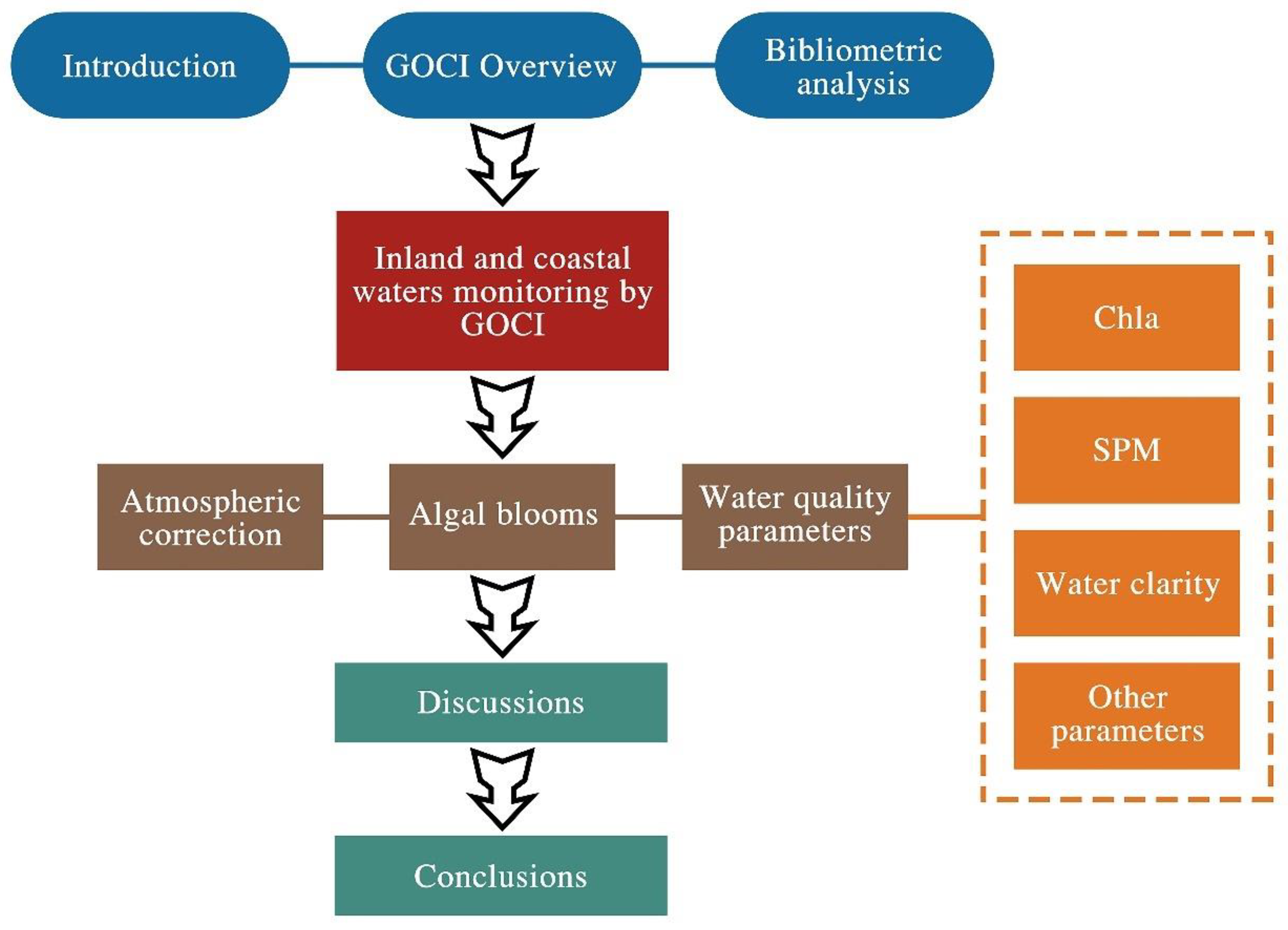
Figure 2.
The Regional Observation Area of GOCI (https://kosc.kiost.ac.kr/index.nm?menuCd=43&lang=en).
Figure 2.
The Regional Observation Area of GOCI (https://kosc.kiost.ac.kr/index.nm?menuCd=43&lang=en).
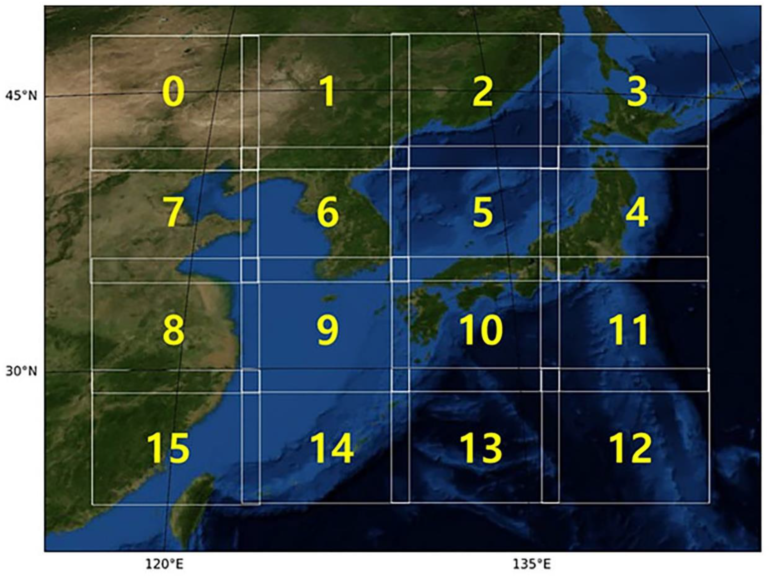
Figure 3.
Number and countries of papers published by GOCI between 2010 and 2023.
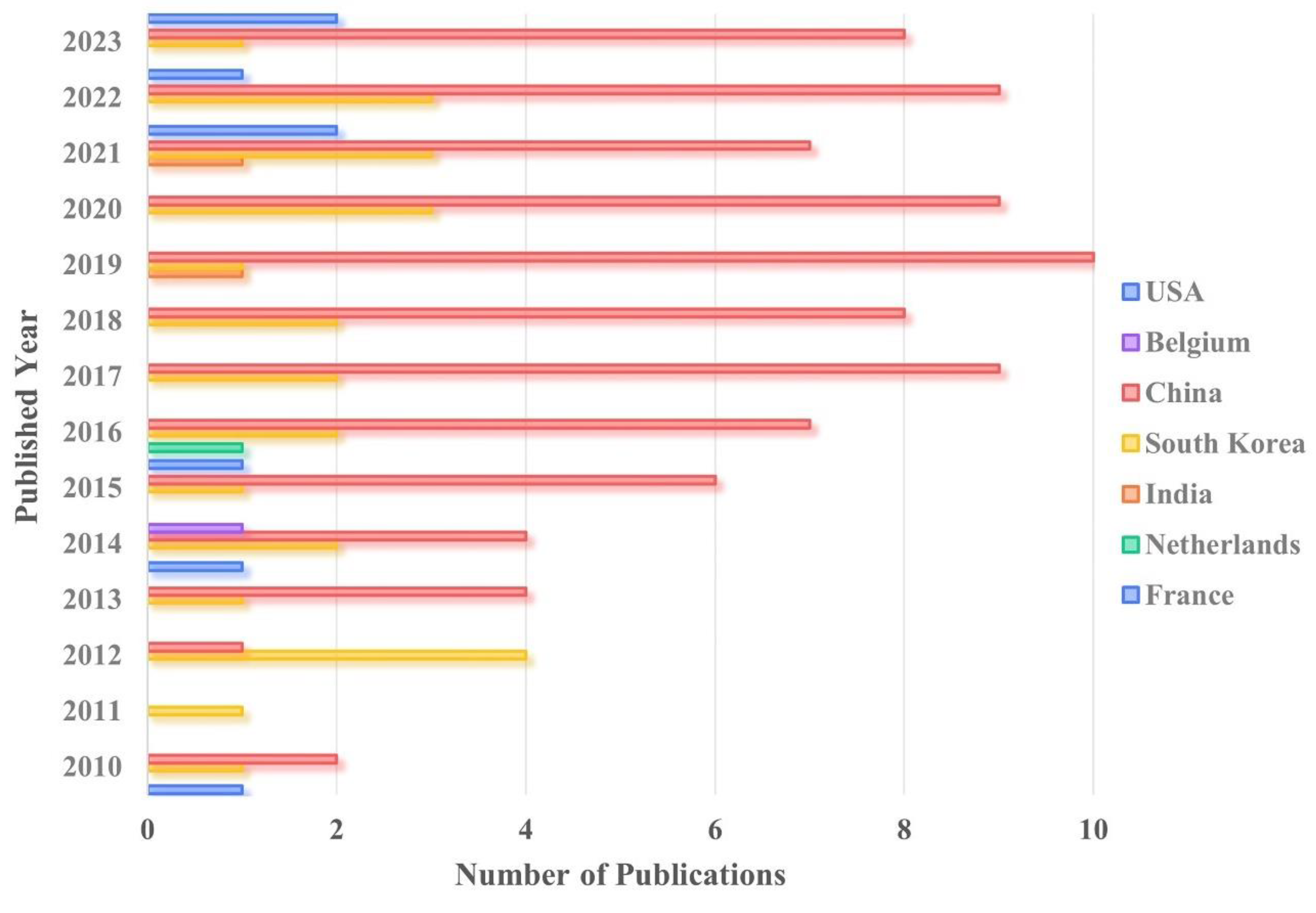
Figure 4.
Map of the study area.
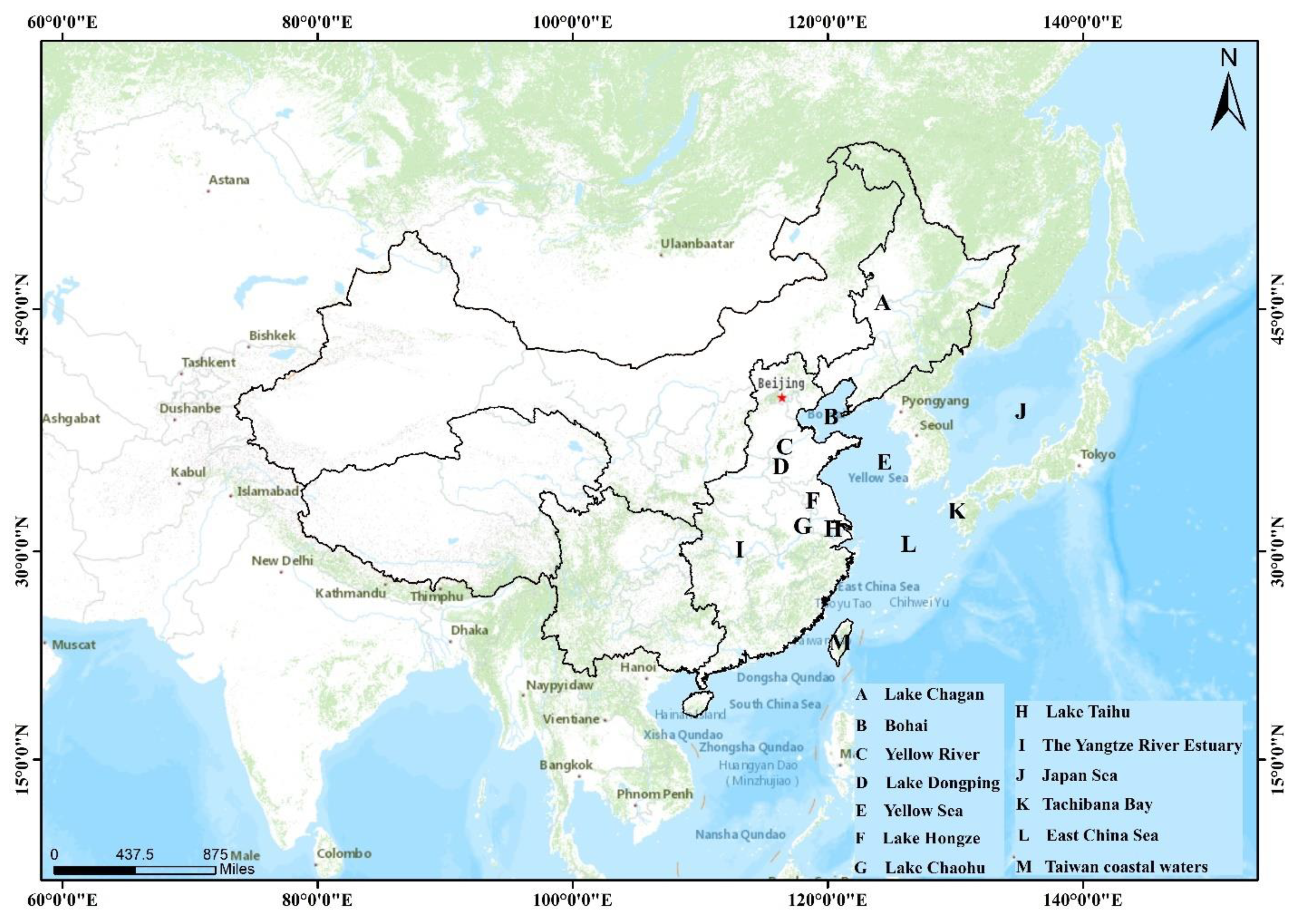
Figure 5.
Journals and number of publications.
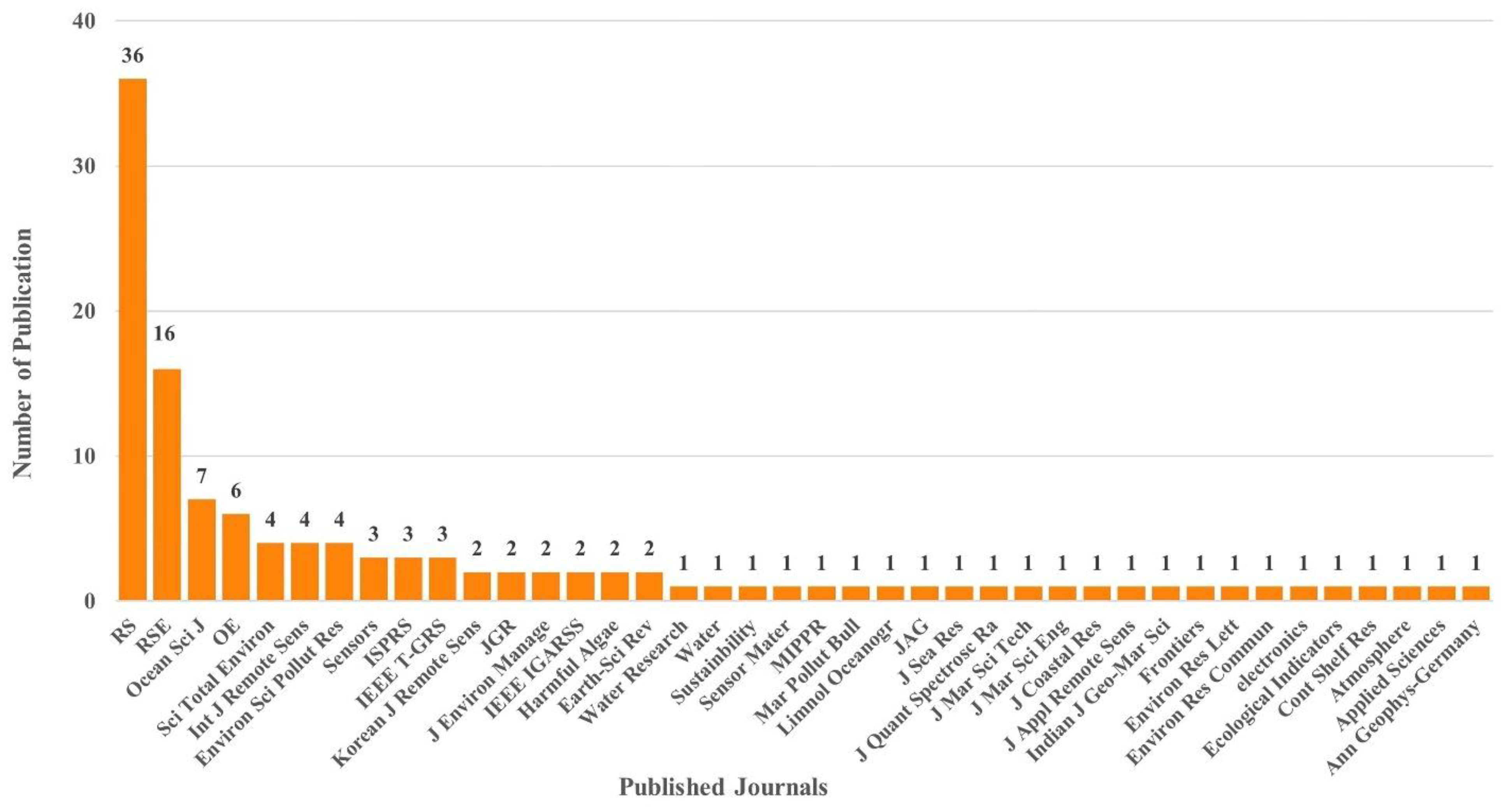
Figure 6.
Keyword mapping from the Web of Science searched by author name.
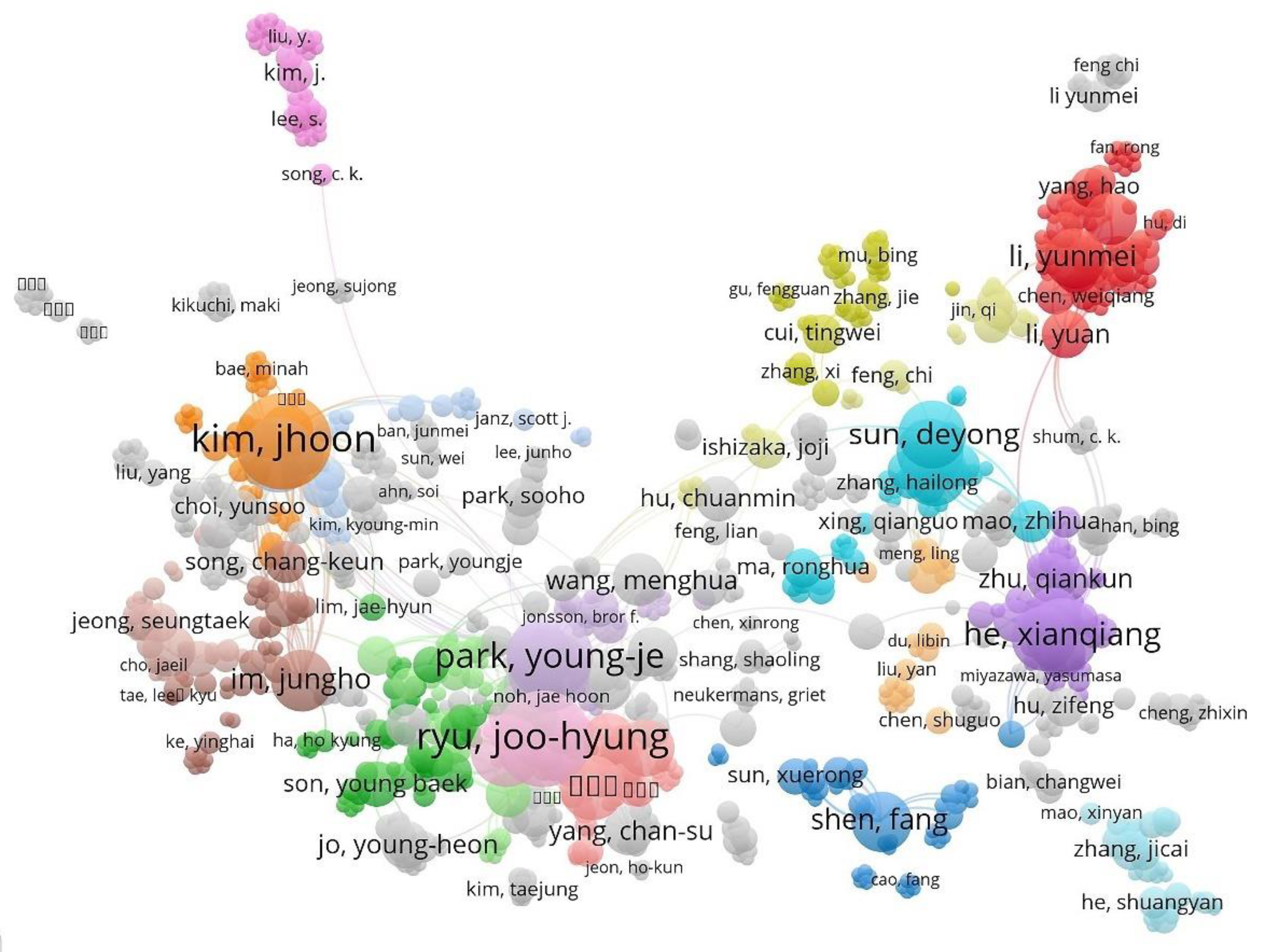
Figure 7.
Overview of the application of GOCI retrieved by subject terms from CNKI.
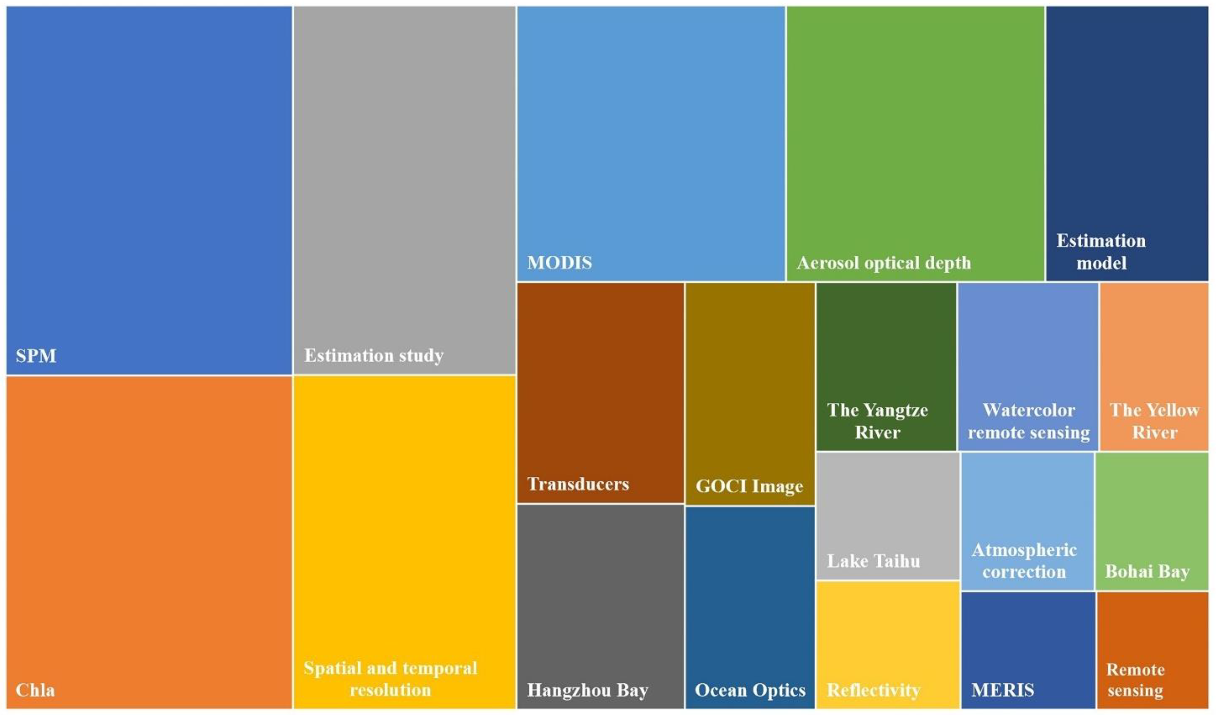
Figure 8.
Application of GOCI in inland and coastal waters.
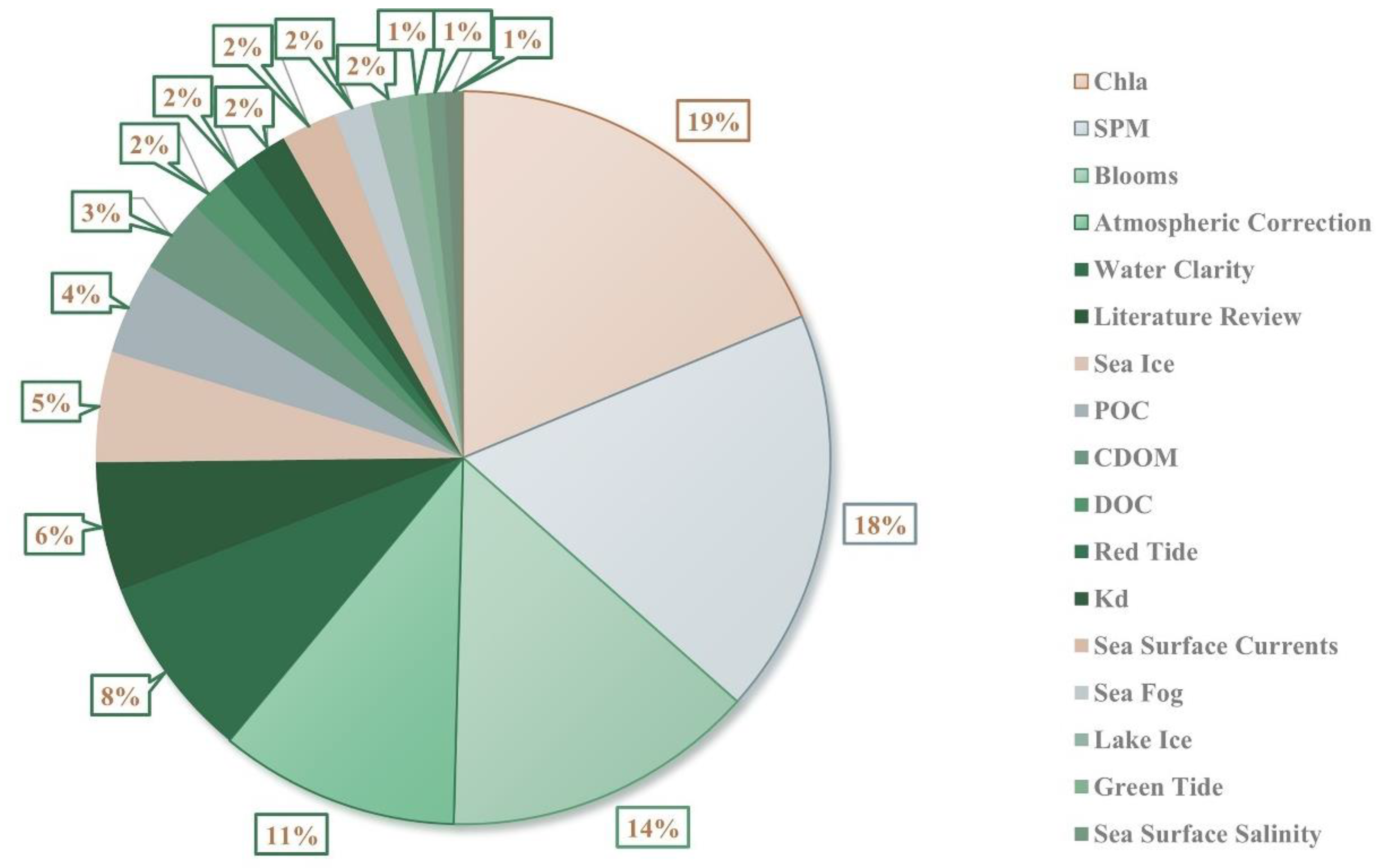
Figure 9.
Schematic diagram of integrated ground-air-space.
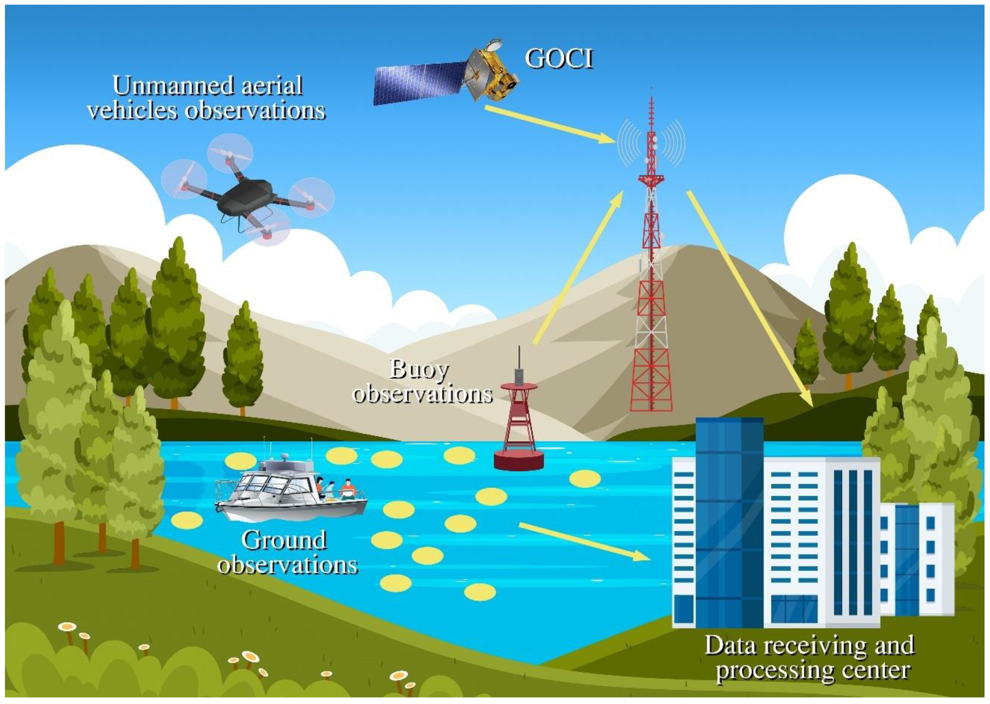
Figure 10.
Schematic diagram of image fusion, taking GOCI-II and Himawari8/9 as an example.
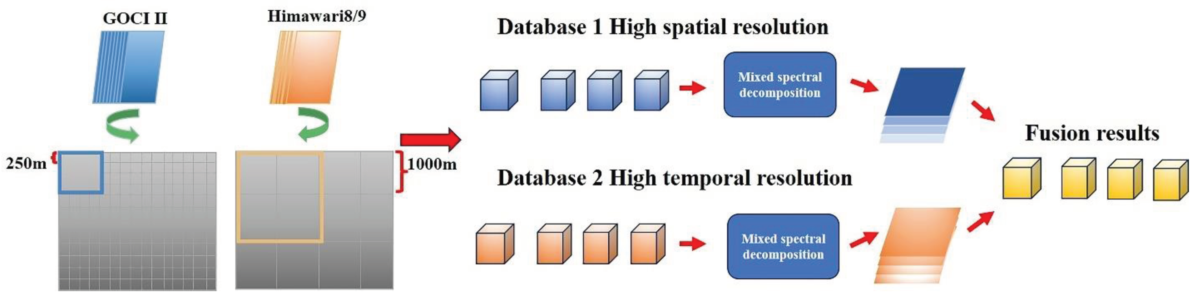

Table 1.
Abbreviations and symbols used in this study.
| Abbreviations or symbols | Abbreviations or symbols | ||
| ABs AFAI AC CNKI Chla CDOM CBI DOC FAC FLH GABI GLI GLIMR HABs IEEE T-GRS ICWs JAG Int J Remote Sens ISPRS LCI MERIS MODIS NASA NIR NPP NDVI NRTI |
Algal blooms Alternative floating algae index Atmospheric correction China National Knowledge Infrastructure Chlorophyll a Colored dissolved organic matter Cyanobacterial bloom intensity Diffuse attenuation coefficient Dissolved organic carbon Floating algae cover Fluorescence line height Generalized algal bloom index algorithm Generation Global Imager Geostationary Littoral Imaging and Monitoring Radiometer Harmful algal blooms IEEE TRANSACTIONS ON GEOSCIENCE AND REMOTE SENSING Inland and coastal waters International Journal of Applied Earth Observation and Geoinformation International Journal of Remote Sensing ISPRS Journal of Photogrammetry and Remote Sensing Linear Combination Index Medium Resolution Imaging Spectrometer Instrument Moderate Resolution Imaging Spectroradiometer National Aeronautics and Space Administration Near-infrared Net primary production Normalized difference vegetation index Normalized red tide index |
OSMI OE POC PC RF RI RS RSE Sci Total Environ SIA SIT SSCs SSS SDD SGLI SWIR SZA SPM SCI GOCI UV VIIRS WR YRE YOC |
Ocean Scanning Multispectral Imager Optics EXPRESS Particulate organic carbon Phycocyanin Random forest Rayleigh-corrected radiance Red tide index Remote sensing Remote Sensing of Environment Remote sensing reflectance Science of the Total Environment Sea ice area Sea ice thickness Sea surface currents Sea surface salinity Secchi disk depth Second Generation Global Imager Shortwave infrared Solar zenith angle Suspended particulate matter Synthetic chlorophyll index The Geostationary Ocean Color Imager Ultraviolet Visible Infrared Imaging Radiometer Water Research Yalu River estuary Yellow and East China Sea Ocean Color |
Table 2.
Comparison of spatial and temporal resolutions of typical watercolor remote sensing satellites and their launch dates.
Table 2.
Comparison of spatial and temporal resolutions of typical watercolor remote sensing satellites and their launch dates.
| Number | Data | Spatial Resolution (m) | Temporal Resolution | Launched Time | |
|---|---|---|---|---|---|
| 1 2 3 4 5 6 7 8 9 10 11 12 13 14 15 16 17 18 19 20 21 22 23 |
CZCS SeaWiFS MODIS_TERRA MODIS_AQUA VIIRS Suomi NPP VIIRS NOAA-20 VIIRS NOAA-21 MERIS Sentinel-3A OLCI Sentinel-3B OLCI ADEOS ADEOS-Ⅱ SGLI HY-1A HY-1B HY-1C HY-1D HY-1E Oceansat-1 Oceansat-2 Oceansat-3 OSMI GOCI |
1000 1100,4500 250,500,1000 250,500,1000 375,750 375,750 375,750 300,1200 300 300 700 250,1000 250 250 250 250 250 100 360 360 360 1000 500 |
One day One day One day One day One day One day One day Three days <Two days <Two days Ten days Four days One day Three days/Seven days One day/Seven days One day/Three days One day/Three days One day/Three days Two days Two days One day/Three days Three days One hour |
1978 1997 1999 2002 2011 2017 2021 2002 2016 2018 1996 2002 2017 2002 2007 2018 2022 2023 1996 2009 2022 1999 2010 |
|
| 24 | GOCI-II | 250 | One hour | 2020 | |
Table 3.
GOCI bands and configuration parameter information.
| Bands | Center Wavelength/nm | Band Width/nm | Spectrum Type | Signal-to-Noise Ratio |
|---|---|---|---|---|
| B1 B2 B3 B4 B5 B6 B7 B8 |
412 443 490 555 660 680 745 865 |
20 20 20 20 20 10 20 40 |
VIS VIS VIS VIS VIS VIS NIR NIR |
1077 1199 1316 1223 1192 1093 1107 1009 |
Table 4.
Band parameters information for GOCI-II.
| Band | Wavelength/nm | Bandwidth/nm | Primary Use |
|---|---|---|---|
| B1 B2 B3 B4 B5 B6 B7 B8 B9 B10 B11 B12 B13 |
380 412 443 490 510 555 620 660 680 709 745 865 PAN |
20 20 20 20 20 20 20 20 10 10 20 40 483 |
CDOM CDOM, Chla Chla absorption maximum Chla, other pigments Chla, absorbing aerosol in ocean waters Turbidity, SPM Detect phytoplankton species Baseline of fluorescence signal, Chla, SPM Fluorescence signal Fluorescence base signal, AC, SPM AC, vegetation index AC, aerosol optical depth / |
Disclaimer/Publisher’s Note: The statements, opinions and data contained in all publications are solely those of the individual author(s) and contributor(s) and not of MDPI and/or the editor(s). MDPI and/or the editor(s) disclaim responsibility for any injury to people or property resulting from any ideas, methods, instructions or products referred to in the content. |
© 2024 by the authors. Licensee MDPI, Basel, Switzerland. This article is an open access article distributed under the terms and conditions of the Creative Commons Attribution (CC BY) license (http://creativecommons.org/licenses/by/4.0/).
Copyright: This open access article is published under a Creative Commons CC BY 4.0 license, which permit the free download, distribution, and reuse, provided that the author and preprint are cited in any reuse.


