
Submitted:
23 March 2024
Posted:
25 March 2024
You are already at the latest version
Abstract
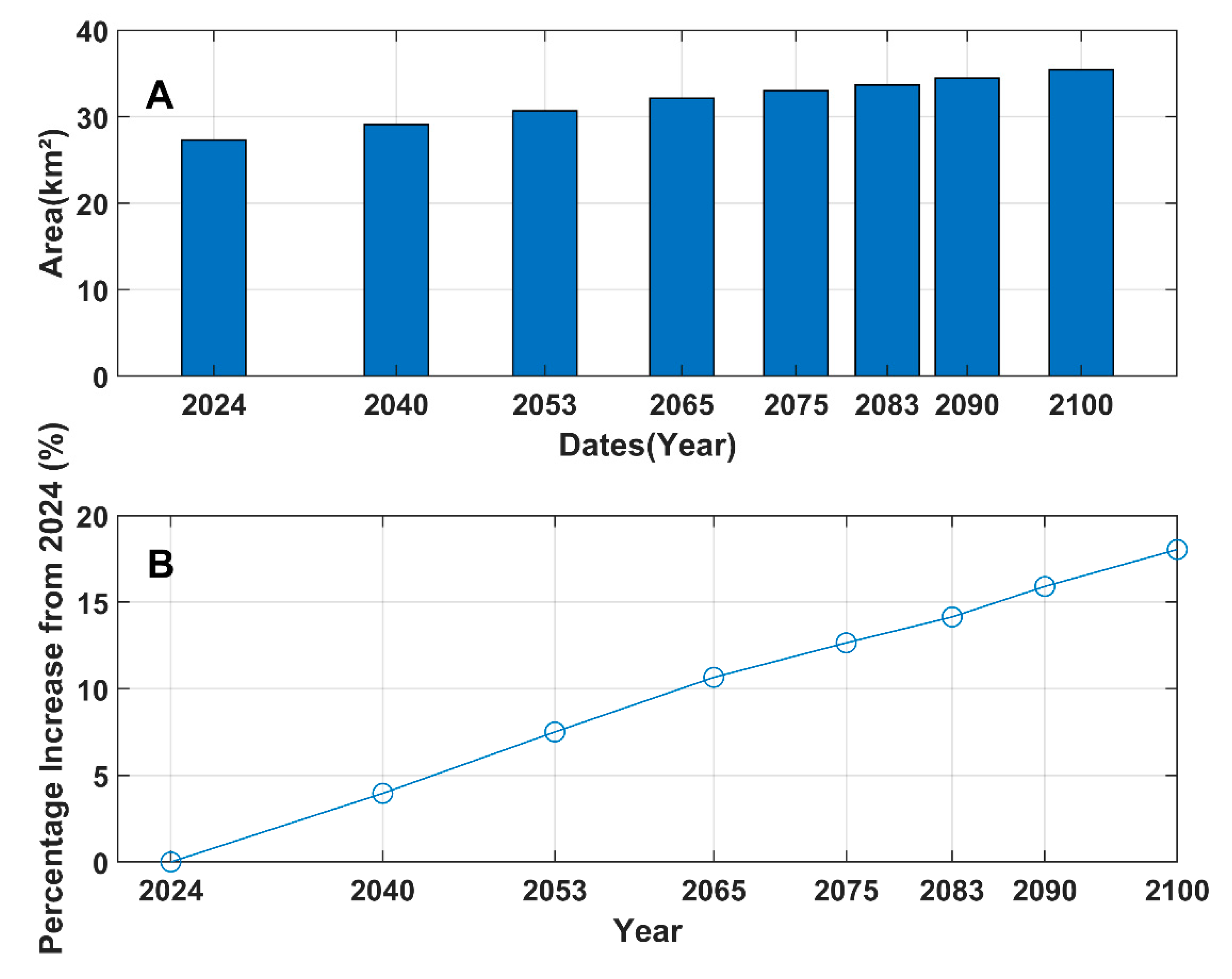
In today's context of rising sea levels and subsiding land topography, coastal flooding is a major concern for coastal areas, both nationally, regionally, and internationally. A detailed understanding of these two phenomena is a prerequisite for effective coastal flood management. The main objective of the present study is to contribute to the understanding of the impact of subsidence and sea-level rise on coastal flooding in Saint-Louis, and in particular the Langue de Barbarie, by producing a vulnerability map of submerged surfaces. To this end, the Synthetic Aperture Radar (SAR) interferometry technique is used to process a time series of Sentinel-1 images and estimate land subsidence in the Saint-Louis and Langue de Barbarie area. Interferometric SAR (InSAR) measurements are merged with RCP 2.6 sea-level rise scenarios to identify predicted flooded areas and provide a flood vulnerability map. At the Langue de Barbarie, topographic subsidence is estimated at between -6.4 and -0.4mm/year. In this study, we show that local land subsidence may increase vulnerability to flooding caused by sea-level rise based on 2100 projections. This may represent an increase in the flood zone in the study area. Based on the RCP 2.6 scenario and the subsidence rates obtained, a significant part of the St. Louis coastline and city would be subject to coastal and fluvial flooding for the years 2040 and 2100. For these dates, 29 to and 36 Km2 of the studied area would be occupied by water. Given this situation, research in Saint-Louis needs to focus on adaptation scenarios to coastal risks, to protect coastal communities and safeguard the city's historical heritage.
Keywords:
sea level rise
; subsidence
; InSAR
; coastal vulnerability
; coastal flooding
; RCP 2.6
Introduction
Today, coastlines are among the world's most vulnerable ecosystems. They are confronted with numerous environmental problems linked to coastal human activities, natural factors, notably sea-level rise, hydrodynamic factors, and coastal subsidence [1,2,3,4,5,6]. In a global context of climatic deterioration, subsidence is one of the most serious threats to coastal ecosystems. Subsidence has become a serious environmental problem on a global scale, threatening urban infrastructures and activities [7,8]. Evaluating land subsidence in 99 global cities, [5] reveal that a considerable number of these urban areas are experiencing subsidence at a faster pace than the rise in sea levels. Should this subsidence persist at its current rate, these cities are likely to encounter coastal flooding earlier than anticipated by conventional sea-level rise models.. Coastal subsidence exacerbates relative sea-level rise, increases the risk of coastal flooding and catalyzes the vulnerability of coastal communities to multiple hazards [6,9]. Many coastal cities characterized by strong littoralization are exposed to subsidence. Subsidence is defined as the downward displacement of the earth's surface relative to a reference point, such as the mean sea level [10,11]. Most coastal areas, especially those in low-lying areas, are the most vulnerable [12,13,14]. Among coastal cities sensitive or even vulnerable to subsidence, Asian coastal cities are the most exposed. According to [5], subsidence is most rapid in South and Southeast Asia. Subsidence is a constantly evolving phenomenon that poses a significant risk to a variety of coastal resources, encompassing both natural resources and coastal issues. Unfortunately, the impact of hazards catalyzed by climate change, such as coastal erosion and flooding, have long been at the forefront of scientific debate on coastal risks. By contrast, other coastal hazards, namely subsidence, have always been relegated to the background. Yet it remains one of the biggest problems in coastal zones, especially in urban areas. Moreover, according to [15], subsidence is becoming increasingly common in urban agglomerations and is worsening due to rising sea levels and accelerating construction. Subsidence in these cities will become increasingly important as they concentrate a significant proportion of the world's population, infrastructure and investment, especially in the context of climate change. Recent studies by [5,16,17] index subsoil mining and rapid coastal urbanization as driving factors for subsidence. Many authors have established a linear relationship between subsidence and sea-level rise. Indeed, authors such as [5,6,15,18,19,20,21,22,23,24] indicate that subsidence increases the threat to coastal communities from sea-level rise, and may even triple the potential areas exposed to coastal flooding and the population at risk by 2070. In many regions, increasing rates of sea-level rise are exacerbated by subsidence [25]. Soil subsidence in coastal areas has disastrous consequences [24]. The impact of coastal subsidence is multifaceted. It can accelerate relative sea-level rise, bring with it a host of potential hazards and threaten the stability of the ecological environment and human lives [26,27]. But, in a context of climate change marked by rising sea levels, its most formidable impact is coastal flooding, especially in densely populated low-lying coastal areas. Given the morphological and topographical diversity of coasts, not all coasts are equally exposed to subsidence. Coastal lowlands, which rise to less than 10 meters above sea level, are particularly vulnerable to the effects of climate change and subsidence [28]. The Saint-Louis coastline, with its similar topographic and geomorphological characteristics, is vulnerable to topographic subsidence. Indeed, this coastline, with its low gradient and sandy facies, is a coastal area at risk. The Saint-Louis coastline, particularly the Langue de Barbarie, is highly vulnerable to the risk of coastal flooding induced by extreme weather and sea conditions in the context of climate change. According to [29,30], coastal flooding is one of the most serious threats to Saint-Louis. Again, according to these authors, this low sandy strip, the Langue de Barbarie, is sensitive to coastal hazards, particularly marine submersion, in that 88% of the territory of Gueth Ndar would be submerged, while 68 and 69% of the districts of Goxxu Mbathie and Ndar Toute would be below the water level induced by the centennial swell. This situation of vulnerability is likely to be exacerbated by the subsidence of the Langue de Barbarie sand barrier in the context of climate change and the exploitation of Saint-Louis' oil and gas resources. The exploitation of oil and gas resources in Saint-Louis could have an impact on the velocity of subsidence in this part of the Senegalese coastline. Over-exploitation of the subsoil contributes significantly to subsidence. Again, according to these authors, notably [31], this subsidence can reach up to 30 cm per year in some cases, then totaling 13m in extreme examples. Despite the disastrous impacts that subsidence could have on the Langue de Barbarie, awareness of the importance of land subsidence on coastal processes and the vulnerability of coastal communities is still slow to emerge. Explicitly, there are no studies on the Senegalese coastline, particularly the Langue de Barbarie, addressing the issue of coastal subsidence. Even though most coastlines, especially low-lying sandy ones, are highly vulnerable to coastal subsidence, the issue of coastal subsidence has never been studied in Senegal, particularly on the Langue de Barbarie. However, studies on subsidence and the vulnerability of coastal communities on the Langue de Barbarie are limited. In this study, the subsidence assessment method (INSAR) will be applied for the first time in Senegal, particularly in Saint-Louis, in order to assess the subsidence of the Langue of Barbarie topography and its implication in coastal flooding; estimate or even detect potential submersible areas under the effect of coastal subsidence and sea-level rise according to different scenarios.
Methodology
The Langue de Barbarie is a strip of sand 120 to 400 m wide with a maximum elevation of 7 meters for a total length of 25 to 30 km [32] set in place by a drift current that settled around 2,000 years BP [33]. From the Mauritanian confines, it starts 3 kilometers north of the town of Saint-Louis, in the Sal-Sal moors, and stretches to 1.5 kilometers south, at Hydrobase.
Figure 1.
Location of study area.
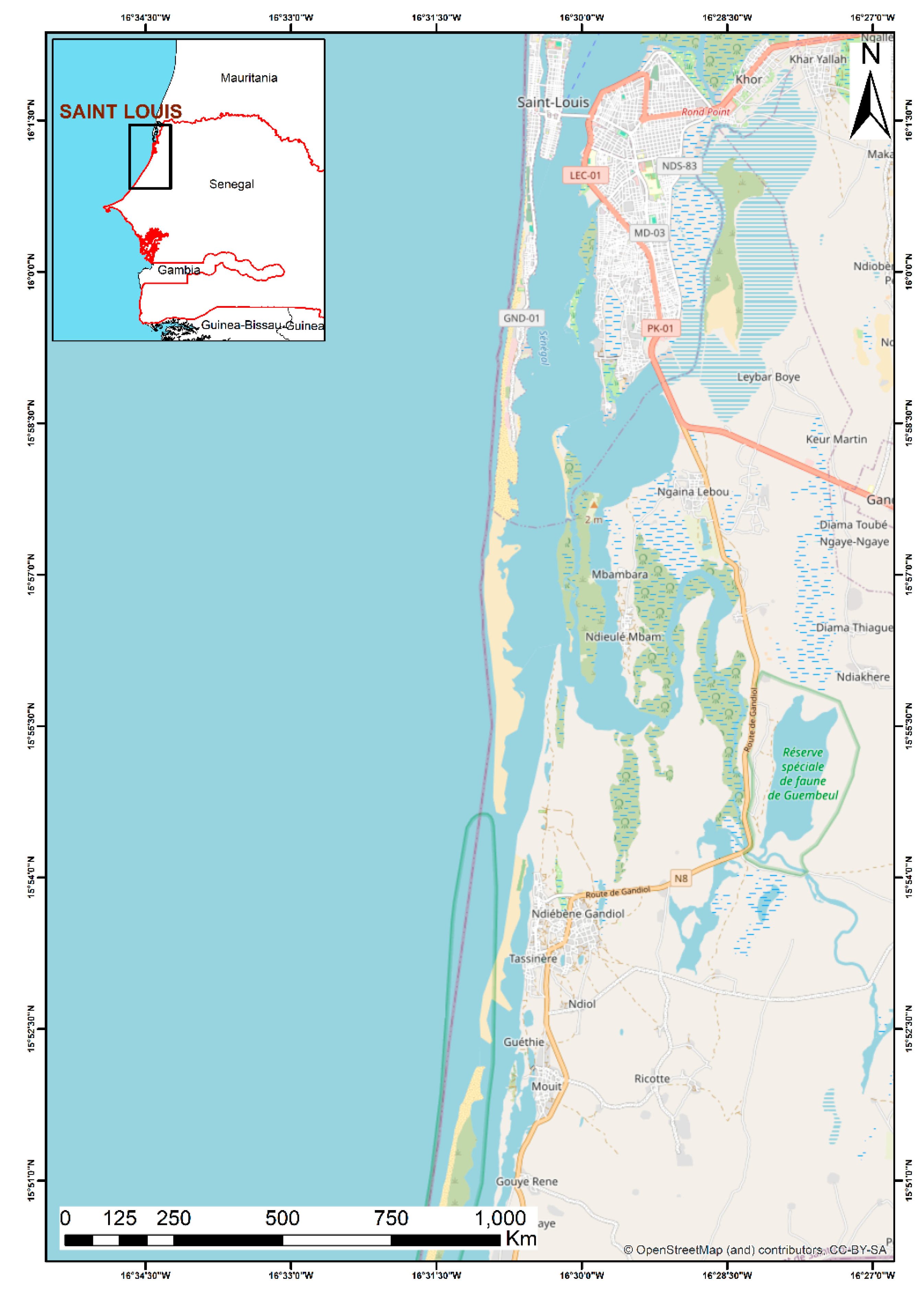
The Langue de Barbarie forms one of the three entities of the city of Saint-Louis (along with the island of Saint-Louis, and Sor, the mainland extension). The site is home to human settlements, artisanal landing ports, tourist facilities and a national park of high environmental value. The sandy facies explains the fragility of this barrier to morphogenic factors [34]. The Langue de Barbarie is one of the most densely populated areas in the city of Saint-Louis. Its 3 main districts (Guet-Ndar, Ndar-Toute, Goxxu Mbacc) account for 27.3% of the population of the 33 districts of the commune of Saint-Louis, or more than 65,000 inhabitants. This portion of Saint-Louis territory is appropriated, developed and used by the group that lives and earns its livelihood there. Today, it is a prime fishing area and an attractive site for tourist activities. The massive increase in population is taking place in a saturated urban fabric. Indeed, the Langue de Barbarie districts are located on a sandy barrier beach under the influence of coastal erosion. The Langue de Barbarie remains overpopulated, due to the combined action of very high demographic pressure and the progressive shrinkage of living space.
Vertical Land Motion
The study used satellite imagery, particularly relying on Sentinel-1A (S1) images taken every six days. These images, which contain both amplitude and phase information, were freely obtained from the Copernicus Science Hub. They provide a stable view of Earth's surface changes because they're usually captured at the same angle. Each image covers a large area, allowing for broad monitoring. By measuring phase differences between images taken in the same way, the Synthetic Aperture Radar (SAR) sensor enables precise detection of land movements. The study collected 70 images per swath from January 2019 to September 2021 for analysis. To track vertical land movements, the study followed a method outlined by [35]. Processing of the images and generation of interferograms were done using the Sentinel Application Platform (SNAP). Another technique called the Stanford Method for Persistent Scatterers (StaMPS) helped analyze persistent scatter patterns over time. The Toolbox for Reducing Atmospheric InSAR Noise (TRAIN) was used to minimize atmospheric interference. SNAP software, which is designed for Sentinel missions, was used for visualizing and processing S1 data. It helps in interferometric processing by incorporating STAMPS packages, which enable a comprehensive analysis of the data over time. The InSAR technique compares phase data from different images to spot inconsistencies. The difference in phase between corresponding pixels is represented mathematically, as described by [36].
Digital Elevation Model Data and Extreme Coastal Water Level (ECWL) Data
To evaluate and model flooding in the Saint Louis Delta, the Digital Elevation Model (DEM) was acquired from the NASA Earth Observing System Data and Information System (EOSDIS) Data Center's website. This version 2 of the Global Digital Elevation Model was constructed using Satellite Radar Altimetry from the Shuttle Radar Topography Mission (SRTM), refining its predecessor by integrating SRTM with Satellite Radar Altimetry data and rectifying inaccuracies through various sources like Global Observations to Benefit the Environment (GLOBE) and the original Altimeter Corrected Elevations (ACE) Digital Elevation Model. Additional enhancements came from reprocessed European Remote Sensing (ERS-1) images. Specifically, three arc seconds data (90 m) resolution was obtained, providing intricate detail crucial for flood assessment and simulation in the Saint Louis Delta. As studied by [37], focusing on future flooding risks in the Volta Delta due to sea level rise and land subsidence, hydrodynamic, meteorological, and tidal parameters essential for computing the Extreme Coastal Water Level (ECWL) were utilized. Data from various sources, including the FES 2014 global tide model and ERA-Interim reanalysis, were integrated to extract key parameters like Sea Level Anomaly (SLA), Wave run-up (R), tide (T), and atmospheric conditions (DAC). By analyzing different trajectories of global mean sea level rise under varying climate change scenarios, such as RCP 2.6 (low-emission, high-mitigation), the study computed future time series for ECWL while maintaining other factors constant, assuming a continued rise in sea-level rates over the RCP projection period. Future relative sea-level rise (RSLR) scenarios were calculated by incorporating ECWL and the average LS rate derived from S1 under different climate scenarios, using WGS84 as the reference datum for both ECWL and land topography.
Bathtub Inundation Model
The study employs the bathtub inundation model concept to assess flooding in the Saint Louis Delta, assuming that areas below a projected flood level will experience flooding akin to a "bathtub." Within a Geographic Information System (GIS) framework, a simple calculation compares the elevation of each cell in a Digital Elevation Model (DEM) with a predicted sea level, categorizing cells with elevations lower than the expected sea level as flooded zones. Using ArcGIS 10.4's raster calculator tool, various relative sea-level rise (SLR) scenarios are processed to evaluate areas with low elevation projection of the delta alongside the ACE 2 DEM under all three Representative Concentration Pathway (RCP) scenarios. This approach, frequently used in similar analyses, relies on simple arithmetic calculations to identify flood-prone areas based on elevation. The methodology's accuracy hinges on the quality of the DEM data and provides insights into flooding depth and extent. To simulate sea-level rise scenarios, the methodology proposed by [37] is adopted, utilizing statistical calculations and map development tools in ESRI's ArcGIS 10.4 and MATLAB software.
Results
The PS-InSAR data illustrates that the coastal area of the Saint Louis Delta has encountered vertical land displacement rates mainly ranging between -6 mm/yr and 6 mm/yr (indicating subsidence or uplift, respectively) from 2019 to 2021. Figure 2 shows the mean vertical ground velocity at Saint-Louis, in particular on the Langue de Barbarie sand spit. This figure shows that the spatial displacement pattern is not uniform throughout the study area. In other words, the rate of soil subsidence or uplift is not homogeneous, but varies from place to place (Figure 2). Our results show that Land subsidence or topography rates at Saint-Louis vary from -6.4 to 2.6mm/year throughout the observation window. Topography subsidence is variable in intensity, with the highest values observed at Langue de Barbarie and Faubourg de Sor.
In the Langue de Barbarie, topographic subsidence is estimated at between -6.4 and -0.4 mm/year. This situation clearly shows that the Langue de Barbarie is exposed to marine waters, especially in a context of climate change marked by a rapid rise in sea level. The results show that the districts of Goxxu Mbathie and Ndar Toute are the most exposed to subsidence. In this part of the Langue de Barbarie, topographic subsidence of the Langue de Barbarie sandy cord varies from -6.4 to -0.4 mm/year, with a slight disparity in that the Goxxu Mbathie district to the north of the Langue de Barbarie is the most affected by coastal subsidence. The island of Saint-Louis is also affected by topographical subsidence, especially in the northern part and the center, where rates vary from -6.4 mm/year to -0.4 mm/year. This part of Saint-Louis, close to the river, could be affected not only by coastal flooding, but also by river overflow. In contrast, the southern part of the island is only slightly affected, by around -0.4 mm/year. Characterized by a low topography, this subsidence observed in Saint-Louis, particularly on the Langue de Barbarie, would cause considerable coastal flooding, especially in a context of climate change marked by rising sea levels.
Moreover, the underlying figure (Figure 3) highlights the involvement of subsidence in the increase in extreme coastal water levels along the Saint-Louis coastline.
This figure (Figure 3) shows a prediction of coastal water level based on ground subsidence rate and sea level rise. Reading Figure 3, it is clear that subsidence conditions strongly influence extreme coastal water levels. For example, for the 2030 scenario, the extreme coastal water level would be 2m, but subsidence influence would cause the extreme coastal water level to rise by 2.10m and respectively 2.09 and 2.24 in 2050. Consequently, land subsidence contributes significantly to extreme coastal water levels in Saint-Louis. The results clearly indicate that when both sea-level rise and land subsidence are taken into account, extreme coastal water levels will increase significantly. Thus, the combination of these two elements, namely subsidence and sea-level rise, undoubtedly has an impact on the spatial extension of submersible surfaces in Saint-Louis and their increase. This is clearly shown in the following figure, Figure 4.
To better understand the synergistic effect of combining SLR (Relative Sea Level Rise) and LS (Subsidence) in coastal inundation simulations, in the present study we designed simulated scenarios (RCP 2.6) in which various SLR and LS conditions were combined. On closer examination, the spatial extent of the inundation is very large, whatever the simulation scenario, and covers a significant part of the Langue de Barbarie. The inundation map shows a fairly significant spatial extension of coastal waters on the Langue de Barbarie. The results indicate a fairly significant occupation of the beaches of the Langue de Barbarie by marine waters. Even with the lowest sea-level rise scenarios, i.e. 2040, there is a significant extension of coastal waters on the hinterland, particularly the continental part, especially on the sandy beaches of the Langue de Barbarie. On closer examination, there is a gradual increase in the spatial coverage of flooded areas up to 2100. This suggests that there could be not just temporary, but permanent flooding of the Langue de Barbarie. Roughly speaking, this figure shows an increase in flooding for all sea-level projections from the RCP 2.6 and RLSR scenarios.
The flooded areas projected in the RCP 2.6 simulation scenarios in 2024, 2040, 2053 and 2100 cover 26, 29, 31 and 36 km2 respectively. Figure 4 and Figure 5 show the predicted flooded coastal areas under the synergetic effect of SLR and LS. Figure 4 shows an increase in floodable areas due to sea-level rise combined with topographic subsidence rates. From the outset, the figure reveals that there is a considerable increase in submersible areas from 2040 onwards, 3 Km2 more than in 2024, i.e. an increase in flood-prone areas of around 5% (Figure 5). On the other hand, over the time sequence 2040-2100, the areas potentially submerged by subsidence and sea-level rise vary from 29 to 36 Km2, i.e. a 10% increase in flood zones. This explains the slight variation in flood-prone areas between 2040 and 2100. Ultimately, the figure shows that the largest floodable areas would be recorded in 2100, on the order of 36 Km2. When sea-level rise and land subsidence are both taken into account, the predicted flooded areas are 26 km2 and 36 km2. In other words, by 2100, 10% of the study area would be under water (Figure 5).
Discussion
As mentioned above, particularly in the introduction, there is no scientific information on topographic subsidence in Saint-Louis, particularly on the Langue de Barbarie. Yet this highly anthropized section of Senegalese coastline, established on a sandy facies with a low gradient, is extremely vulnerable to coastal hazards (erosion and coastal flooding) [29,30,38,39,40,41] Today, in a context of climate change and the exploitation of oil and gas resources in Saint-Louis, a study focusing on the problem of coastal subsidence seems important. The topographic subsidence rates obtained clearly show that a large part of Saint-Louis is sinking downwards, which could have considerable impacts for an amphibious city like Saint-Louis, marked by its openness to the Atlantic coast and the presence of the river. This region in the Senegal River delta is highly vulnerable. Coastal plains and deltaic regions are the areas most affected worldwide by sea-level rise and subsidence [5,42,43].The increase in extreme coastal water levels due to the combination of subsidence and sea-level rise is proving more serious than sea-level rise alone (Figure 3). This shows that topographic subsidence has a strong impact on this section of the Senegalese coastline. This observation is in line with studies by [5,44].The combination of subsidence and SLR predicts a range of inundation and submersion extents that may affect Saint-Louis, including the Langue de Barbarie (Figure 4). Starting with coastal flooding patterns due to subsidence and sea-level rise, the total area affected reaches 29 km2 by 2040, 31 km2 by 2050, 36 km2 by 2100, and affects almost all of Saint-Louis, particularly the Langue de Barbarie. The extent of inundation due to sea-level rise and the combined effect of land subsidence and sea-level rise were assessed taking into account several sea-level rise projections according to the RCP 2.6 scenario. The RCP2.6 scenario corresponds to an emissions volume equal to the Paris Agreement targets, in which there is a 2015 emissions reduction [45]. Thus, there is a minimization of the floodable surfaces of the Langue de Barbarie depending on the scenario chosen. Otherwise, if there is no reduction in emissions, the projected submersible surfaces will be far exceeded. If further acceleration in sea-level rise is expected, the already problematic situation will worsen. Our results also show that the projected potential for coastal inundation is increasing more and more under the effect of factors related to rising sea levels and subsidence. This finding is also by [46] in Louisiana, USA, [47] along the US Atlantic coast; [48] in South Florida, USA; [49] in Germany; [50] in Jakarta, Indonesia; [51,52] in Italy; [53] in Shanghai, China; [54] in Semarang, Indonesia; [55,56] in Messolonghi and Aitolikon, Greece; [37] Brempong in the Volta delta, Ghana; [23] in Taiwan; [18,22,53,57,58,59] in China. The general pattern of subsidence indicates very high values in the northern part of the Langue de Barbarie, the island of Saint-Louis and its central part, while areas to the south of the Langue de Barbarie and the island of Saint-Louis have experienced minimal subsidence. Today, with climate change leading to a rise in sea level and a high occurrence of marine storms, the vulnerability of this site to coastal flooding is a reality. Although rainfall is not taken into account in this study, the average total rainfall accumulation can sometimes reach several hundred millimetres, which will increase the river's flow. What's more, given its amphibious character marked above all by the presence of the river in a context of gradual return of rains in the Sahel [60,61,62], the risk of fluvial overflow exacerbated by soil subsidence and a rise in the river's water level induced by the gradual return of rains is obvious. The same observation is made by [63,64], who show that the city of Ho Chi Minh in Vietnam is subject to fluvial flooding due to the subsidence of the topography and the increased flow of the Saigon River.Our results are in line with those produced by [65,66], in the Mekong delta in Vietnam, in Spain in the Seville river by [67] ; [68] in Poland in the Chechło river; [69] in Hungary and [44] in the Ganges-Brahmaputra-Meghna delta and [70] in the Fraser River delta. Today, many factors are indexed by the scientific community as being the cause of subsidence. These include earthquakes, sea-level rise, infrastructure development and sediment transport. "Subsidence is a geological phenomenon in which the ground level sags or subsides for a variety of reasons [11]. This can occur naturally or due to human activities such as groundwater extraction, oil and gas extraction and construction activities [5,71,72,73,74,75,76,77]. But in Saint-Louis, the factors associated with pumping the aquifer for water supply seem to be neglected. On the other hand, one of the main causes could be the characteristics of the sediments and their compaction. Located in the Senegal River Delta, the sedimentary structures of Saint-Louis are mainly occupied by a variety of deposits (clays and especially silts and fine sands), all of which are described as fluvio-deltaic [78]. According to [10,12,72,79,80,81,82], natural compaction of sediments can be an explanatory factor for subsidence. This sediment compaction can result from increased surface loading, such as the accumulation of new sediments or the construction of heavy infrastructure. Heavy infrastructure can be a trigger for topographic subsidence [83], especially in loose structures. According to [64], the weight of buildings leads to mechanical settlement of soils, which amplifies the subsidence trend. On an 2.15 Km stretch of the Langue de Barbarie, a protective dike was under construction over the time sequence chosen to track topographical subsidence. In fact, Figure 2 shows that the linear stretch of the Langue de Barbarie where the dike is being built (north and center) appears to have the highest subsidence rates. In addition, the natural deposition of river and marine sediments could explain this phenomenon of topographical subsidence. In fact, according to [10], one of the main causes of subsidence in coastal regions is the natural deposition of sediments. As sediments are deposited in these areas, their weight compresses the underlying soils, forcing them to compact, which can cause changes in the underlying geological structures.The results show that the Langue de Barbarie is highly vulnerable to coastal flooding induced by sea-level rise and subsidence. The results of this study could form a solid basis for sustainable development and disaster prevention policies in the city of Saint-Louis and its coastline. Today, climate change amplifies coastal risks, combined with the absence of a coercive legislative framework, an institutional framework, an effective adaptation plan and the implementation of a coastal risk prevention plan, mean that this coastline remains vulnerable to coastal hazards. Even though the results show an increased vulnerability of the Langue de Barbarie, there is virtually no coastal risk prevention plan in place. Indeed, according to [84], few if any African coastal cities are prepared to cope with the impacts of coastal hazards and climate change, particularly sea-level rise. Today, it is imperative to turn the research cursor towards adaptation scenarios to coastal hazards on the Langue de Barbarie, and to identify useful avenues for improving public measures relating to the vulnerability and resilience of low-lying sandy coastlines, notably the Langue de Barbarie.
Conclusion
Coastal flooding is a real problem in most parts of the world. Low-lying, sandy coastlines are the hardest hit, as is the case for the beaches of the Langue de Barbarie in Saint-Louis. Today, as sea levels rise and land topography subsides, coastal flooding is likely to increase. Analysis of the results obtained in this study shows that subsidence is a real problem in this section of the Senegalese coastline. It contributes significantly to the extension of submersible surfaces. The combination of rising sea levels and subsidence revealed that 42 km 2 of Saint-Louis would be under coastal and fluvial waters. Notwithstanding this vulnerability, there is virtually no coastal risk prevention and management plan for Saint-Louis. Today, research carried out on this highly vulnerable site needs to be directed in this direction. Ultimately, the results of this study can play a particularly vital role in assessing the information essential for decision-making, management and protection of coastal communities. They can be used for land-use planning purposes, as well as for the development of coastal hazard adaptation plans in the context of climate change.
References
- Woodruff, J.D., Irish, J.L., and Camargo, S.J. (2013). Coastal flooding by tropical cyclones and sea-level rise. Nature, 504, 44-51.
- Luijendijk, A., Hagenaars, G., Ranasinghe, R., Baart, F., Donchyts, G., & Aarninkhof, S. (2018). The state of the world’s beaches. Scientific reports, 8(1), 6641.
- Wang, L., Zhang, M., Wen, J, Chong, Z., Ye, Q., and Ke, Q. (2019). Simulation of extreme compound coastal flooding in Shanghai[J]. Advances in Water Science, 30(4): 546-555. [CrossRef]
- Vousdoukas, M. I., Clarke, J., Ranasinghe, R., Reimann, L., Khalaf, N., Duong, T. M., ... & Simpson, N. P. (2022). African heritage sites threatened as sea-level rise accelerates. Nature Climate Change, 12(3), 256-262. Nature Climate Change.
- Wu, P. C., Wei, M., & D’Hondt, S. (2022). Subsidence in coastal cities throughout the world observed by InSAR. Geophysical Research Letters, 49(7), e2022GL098477.
- Ohenhen, L. O., Shirzaei, M., & Barnard, P. L. (2024). Slowly but surely: Exposure of communities and infrastructure to subsidence on the US east coast. PNAS nexus, 3(1), pgad426.
- Liu, S. P., Shi, B., Gu, K., Zhang, C. C., Yang, J. L., Zhang, S., & Yang, P. (2020). Land subsidence monitoring in sinking coastal areas using distributed fiber optic sensing: a case study. Natural Hazards, 103, 3043-3061.
- Herrera-García, G., Ezquerro, P., Tomás, R., Béjar-Pizarro, M., López-Vinielles, J., Rossi, M., ... & Ye, S. (2021). Mapping the global threat of land subsidence. Science, 371(6524), 34-36.
- Li, P., Wang, G., Liang, C., Wang, H., & Li, Z. (2023). InSAR-derived Coastal Subsidence Reveals New Inundation Scenarios over the Yellow River Delta. IEEE Journal of Selected Topics in Applied Earth Observations and Remote Sensing.
- Meem, M. S., Islam, M. S., & Debnath, P. (2016). Subsidence in the coastal belt of Bangladesh and its implication to the coastal dynamics and ecosystem. Coastal and marine environment of Bangladesh. BAPA-BEN, 138-151.
- Chai, L., Xie, X., Wang, C., Tang, G., & Song, Z. (2024). Ground subsidence risk assessment method using PS-InSAR and LightGBM: a case study of Shanghai metro network. International Journal of Digital Earth, 17(1), 2297842.
- Higgins, S. A. (2016). Advances in delta-subsidence research using satellite methods. Hydrogeology Journal, 24(3), 587.
- Nienhuis, J. H., Törnqvist, T. E., Jankowski, K. L., Fernandes, A. M., & Keogh, M. E. (2017). A new subsidence map for coastal Louisiana. GSA Today, 27(9), 58-59.
- Noubissie, L. D., Birol, F., Onguene, R., Léger, F., Niño, F., & Naoussi, R. D. (2024). Virtual coastal altimetry tide gauges along the West African coast. Estuarine, Coastal and Shelf Science, 296, 108600.
- Zhao, S., Li, P., Li, H., Zhang, T., & Wang, B. (2023). Monitoring and Comparative Analysis of Hohhot Subway Subsidence Using StaMPS-PS Based on Two DEMS. Remote Sensing, 15(16), 4011.
- Shi, X., Zhang, S., Jiang, M., Pei, Y., Qu, T., Xu, J., & Yang, C. (2021). Spatial and temporal subsidence characteristics in Wuhan (China), during 2015–2019, inferred from Sentinel-1 synthetic aperture radar (SAR) interferometry. Natural Hazards and Earth System Sciences, 21(8), 2285-2297.
- Fajrin, F., Almegi, A., Bakari, A., Ramadhan, R., & Antomi, Y. (2021). Enviromental monitoring of land subsidence in the coastal area of padang city using sentinel 1 sar dataset. Sumatra Journal of Disaster, Geography and Geography Education, 5(1), 30-34.
- Wang, J., Gao, W., Xu, S., & Yu, L. (2012). Evaluation of the combined risk of sea level rise, land subsidence, and storm surges on the coastal areas of Shanghai, China. Climatic change, 115, 537-558.
- Raucoules, D., Le Cozannet, G., Wöppelmann, G., De Michele, M., Gravelle, M., Daag, A., & Marcos, M. (2013). High nonlinear urban ground motion in Manila (Philippines) from 1993 to 2010 observed by DInSAR: implications for sea-level measurement. Remote sensing of environment, 139, 386-397.
- Shirzaei, M., & Bürgmann, R. (2018). Global climate change and local land subsidence exacerbate inundation risk to the San Francisco Bay Area. Science advances, 4(3), eaap9234.
- Shirzaei, M., Freymueller, J., Törnqvist, T. E., Galloway, D. L., Dura, T., & Minderhoud, P. S. (2021). Measuring, modelling and projecting coastal land subsidence. Nature Reviews Earth & Environment, 2(1), 40-58.
- Fang, J., Nicholls, R. J., Brown, S., Lincke, D., Hinkel, J., Vafeidis, A. T., ... & Shi, P. (2022). Benefits of subsidence control for coastal flooding in China. Nature Communications, 13(1), 6946.
- Hsiao, S. C., Fu, H. S., Chen, W. B., Chang, T. Y., Wu, H. L., & Liang, T. Y. (2022). Assessment of future possible maximum flooding extent in the midwestern coastal region of Taiwan resulting from sea-level rise and land subsidence. Environmental Research Communications, 4(9), 095007.
- Wang, G., Li, P., Li, Z., Liu, J., Zhang, Y., & Wang, H. (2024). InSAR and machine learning reveal new understanding of coastal subsidence risk in the Yellow River Delta, China. Science of The Total Environment, 170203.
- Simms, A. R., Anderson, J. B., DeWitt, R., Lambeck, K., & Purcell, A. (2013). Quantifying rates of coastal subsidence since the last interglacial and the role of sediment loading. Global and planetary change, 111, 296-308.
- Du, Y., Feng, G., Liu, L., Fu, H., Peng, X., & Wen, D. (2020). Understanding land subsidence along the coastal areas of Guangdong, China, by analyzing multi-track MTInSAR data. Remote Sensing, 12(2), 299.
- Zhong, W., Chu, T., Tissot, P., Wu, Z., Chen, J., & Zhang, H. (2022). Integrated coastal subsidence analysis using InSAR, LiDAR, and land cover data. Remote Sensing of Environment, 282, 113297.
- Arikawa, T., Muhari, A., Okumura, Y., Dohi, Y., Afriyanto, B., Sujatmiko, K. A., & Imamura, F. (2018). Coastal subsidence induced several tsunamis during the 2018 Sulawesi earthquake. Journal of Disaster Research, 13(Scientific Communication), sc20181201.
- Cissé, C.O.T., Brempong, E.K, Taveneau, A., Almar, R., Sy, B.A and Angnuureng, D.B. (2022a). Extreme coastal water levels with potential flooding risk at the low-lying Saint Louis historic city, Senegal (West Africa). Front. Mar. Sci. 9:993644. [CrossRef]
- Cissé, C. O. T., SY, B., DIA, A. T., Taveneau, A., SY, B. A., (2022b) – Mapping flood-prone areas based on an extreme water level of centennial occurrence on a low sandy barrier beach (Langue de Barbarie), in line with the urban site of Saint-Louis, Senegal. Review of social sciences university Peleforo Gon Coulibaly de Korhogo, Côte D’Ivoire, n°3, december, p.185-201.
- Ingebritsen, S. E., & Galloway, D. L. (2014). Coastal subsidence and relative sea level rise. Environmental Research Letters, 9(9), 091002.
- SY, A.A. (2013). Sediment dynamics and current risks in the Saint-Louis-Gandiol axis, littoral Nord du Sénégal, Doctoral thesis in geography, Gaston Berger University (UGB), 333 p.
- SY, A.B., SY, A.A., Bodian, A., Faye C.A.T, Niang, S., DIOP, M., Ndiaye, M. (2015). «Breach" opened on the Langue de Barbarie in Saint-Louis Sketch of the results of a hasty development project, L’Harmattan, 136 p.
- Sy B. A., Bilbao I. A., Sy A .A, Perez I. S., Rodriguez Valido S. (2013). Results of the 2010-2012 monitoring of the evolution of the breach opened on the Langue de Barbarie in Senegal and its consequences. Physio-Geo, 7 (1), 223-242.
- Mancini, F., Grassi, F., & Cenni, N. (2021). A workflow based on SNAP–StaMPS open-source tools and GNSS data for PSI-Based ground deformation using dual-orbit sentinel-1 data: Accuracy assessment with error propagation analysis. Remote Sensing, 13(4), 753.
- Rocca, F., Prati, C., Monti Guarnieri, A., & Ferretti, A. (2000). SAR interferometry and its applications. Surveys in Geophysics, 21, 159-176.
- Brempong, E. K., Almar, R., Angnuureng, D. B., Mattah, P. A. D., Avornyo, S. Y., Jayson-Quashigah, P. N., ... & Teatini, P. (2023). Future flooding of the Volta Delta caused by sea level rise and land subsidence. Journal of Coastal Conservation, 27(3), 24.
- Ndour, A., Laïbi, R. A., Sadio, M., Degbe, C. G., Diaw, A. T., Oyédé, L. M., ... & Sambou, H. (2018). Management strategies for coastal erosion problems in West Africa: analysis, issues, and constraints drawn from the examples of Senegal and Benin. Ocean & Coastal Management, 156, 92-106.
- Ndour, A., Ba, K., Almar, A., Almeida, P., Sall, M., Diedhiou, P. M., ... & Sy, B. (2020). On the natural and anthropogenic drivers of the Senegalese (West Africa) low coast evolution: Saint Louis beach 2016 COASTVAR experiment and 3D modeling of short term coastal protection measures. Journal of Coastal Research, 95(SI), 583-587.
- Taveneau, A., Almar, R., Bergsma, E. W., Sy, B. A., Ndour, A., Sadio, M., & Garlan, T. (2021). Observing and predicting coastal erosion at the Langue de Barbarie sand spit around Saint Louis (Senegal, West Africa) through satellite-derived digital elevation model and shoreline. Remote Sensing, 13(13), 2454.
- Faye, M. (2023). Final thesis: Impacts of coastal erosion on the vulnerability of the "Langue de Barbarie" population in Saint-Louis in a context of climate change: diagnosis and adaptation strategies, Master's thesis specializing in risk and disaster management, University of Liége, Belgium., 80p.
- Hanebuth, T. J., Kudrass, H. R., Linstädter, J., Islam, B., & Zander, A. M. (2013). Rapid coastal subsidence in the central Ganges-Brahmaputra Delta (Bangladesh) since the 17th century deduced from submerged salt-producing kilns. Geology, 41(9), 987-990.
- Bagheri-Gavkosh, M., Hosseini, S. M., Ataie-Ashtiani, B., Sohani, Y., Ebrahimian, H., Morovat, F., & Ashrafi, S. (2021). Land subsidence: A global challenge. Science of The Total Environment, 778, 146193.
- Becker, M., Papa, F., Karpytchev, M., Delebecque, C., Krien, Y., Khan, J. U., ... & Shum, C. K. (2020). Water level changes, subsidence, and sea level rise in the Ganges–Brahmaputra–Meghna delta. Proceedings of the National Academy of Sciences, 117(4), 1867-1876.
- Catalao, J., Raju, D., & Nico, G. (2020). InSAR maps of land subsidence and sea level scenarios to quantify the flood inundation risk in coastal cities: The case of Singapore. Remote Sensing, 12(2), 296.
- Burkett, V. R., Zilkoski, D. B., & Hart, D. A. (2002). Sea-level rise and subsidence: implications for flooding in New Orleans, Louisiana. In US Geological Survey Subsidence Interest Group Conference. US Geological Survey, Galveston, Texas (pp. 63-71).
- Fiaschi, S., & Wdowinski, S. (2020). Local land subsidence in Miami Beach (FL) and Norfolk (VA) and its contribution to flooding hazard in coastal communities along the US Atlantic coast. Ocean & Coastal Management, 187, 105078.
- Wdowinski, S., Oliver-Cabrera, T., & Fiaschi, S. (2020). Land subsidence contribution to coastal flooding hazard in southeast Florida. Proceedings of IAHS, 382, 207-211.
- Hoogland, T., Van den Akker, J. J. H., & Brus, D. J. (2012). Modeling the subsidence of peat soils in the Dutch coastal area. Geoderma, 171, 92-97.
- Abidin, H. Z., Andreas, H., Gumilar, I., & Wibowo, I. R. R. (2015). On correlation between urban development, land subsidence and flooding phenomena in Jakarta. Proceedings of IAHS, 370, 15-20.
- Aucelli, P. P. C., Di Paola, G., Incontri, P., Rizzo, A., Vilardo, G., Benassai, G., ... & Pappone, G. (2017). Coastal inundation risk assessment due to subsidence and sea level rise in a Mediterranean alluvial plain (Volturno coastal plain–southern Italy). Estuarine, Coastal and Shelf Science, 198, 597-609.
- Anzidei, M., Bosman, A., Carluccio, R., Casalbore, D., D'Ajello Caracciolo, F., Esposito, A., ... & Sepe, V. (2017). Flooding scenarios due to land subsidence and sea-level rise: a case study for Lipari Island (Italy). Terra Nova, 29(1), 44-51.
- Wang, J., Yi, S., Li, M., Wang, L., & Song, C. (2018). Effects of sea level rise, land subsidence, bathymetric change and typhoon tracks on storm flooding in the coastal areas of Shanghai. Science of the total environment, 621, 228-234.
- Irawan, A. M., Marfai, M. A., Nugraheni, I. R., Gustono, S. T., Rejeki, H. A., Widodo, A., ... & Faridatunnisa, M. (2021). Comparison between averaged and localised subsidence measurements for coastal floods projection in 2050 Semarang, Indonesia. Urban Climate, 35, 100760.
- Van Bijsterveldt, C. E., Herman, P. M., van Wesenbeeck, B. K., Ramadhani, S., Heuts, T. S., van Starrenburg, C., ... & Bouma, T. J. (2023). Subsidence reveals potential impacts of future sea level rise on inhabited mangrove coasts. Nature Sustainability, 6(12), 1565-1577.
- Antoniadis, N., Alatza, S., Loupasakis, C., & Kontoes, C. (2023). Land Subsidence Phenomena vs. Coastal Flood Hazard—The Cases of Messolonghi and Aitolikon (Greece). Remote Sensing, 15(8), 2112.
- Navarro-Hernández, M. I., Valdes-Abellan, J., Tomás, R., Tessitore, S., Ezquerro, P., & Herrera, G. (2023). Analysing the impact of land subsidence on the flooding risk: evaluation through InSAR and modelling. Water Resources Management, 37(11), 4363-4383.
- Jiang, H., Zhang, J., Liu, Y., Li, J., & Fang, Z. N. (2023). Does flooding get worse with subsiding land? Investigating the impacts of land subsidence on flood inundation from Hurricane Harvey. Science of the total environment, 865, 161072.
- Zhao, Q., Pan, J., Devlin, A., Xu, Q., Tang, M., Li, Z., ... & Pepe, A. (2021). Integrated analysis of the combined risk of ground subsidence, sea level rise, and natural hazards in coastal and Delta River Regions. Remote Sensing, 13(17), 3431.
- Sene, S., & Ozer, P. (2002). Evolution pluviométrique et relation inondations–événements pluvieux au Sénégal. Bulletin de la Société géographique de Liège, 42.
- Vischel T., Lebel Thierry, Panthou G., Quantin G., Rossi A., Martinet M. Le retour d'une période humide au Sahel ? : observations et perspectives. In : Sultan Benjamin (ed.), Lalou Richard (ed.), Amadou Sanni M. (ed.), Oumarou A. (ed.), Soumaré M.A. (ed.). Les sociétés rurales face aux changements climatiques et environnementaux en Afrique de l'Ouest. Marseille : IRD, 2015, p. 43-60. (Synthèses). ISBN 978-2-7099-2146-6.
- Nouaceur, Z. (2020). La reprise des pluies et la recrudescence des inondations en Afrique de l'Ouest sahélienne », Physio-Géo [En ligne], Volume 15 | 2020, mis en ligne le 13 avril 2020, URL : http://journals.openedition.org/physio-geo/10966. [CrossRef]
- Tran, A.V.; Brovelli, M.A.; Ha, K.T.; Khuc, D.T.; Tran, D.N.; Tran, H.H.; Le, N.T.(2024) .Land Subsidence Susceptibility Mapping in Ca Mau Province, Vietnam Using Boosting Models. Preprints, 2024011854. [CrossRef]
- Vachaud, G., Gratiot, N., et Tran Ngoc, T. D. (2020). « Ho Chi Minh City, from flooding to submersion … ». EchoGéo 52: http://journals.openedition.org/echogeo/19473. [CrossRef]
- Erban, L. E., Gorelick, S. M., & Zebker, H. A. (2014). Groundwater extraction, land subsidence, and sea-level rise in the Mekong Delta, Vietnam. Environmental Research Letters, 9(8), 084010.
- Takagi, H., Thao, N. D., & Anh, L. T. (2016). Sea-level rise and land subsidence: impacts on flood projections for the Mekong Delta’s largest city. Sustainability, 8(9), 959.
- Ruiz-Constán, A., Ruiz-Armenteros, A. M., Galindo-Zaldívar, J., Lamas-Fernández, F., Sousa, J. J., Sanz de Galdeano, C., ... & Gil, A. J. (2017). Factors determining subsidence in urbanized floodplains: evidence from MT-InSAR in Seville (southern Spain). Earth Surface Processes and Landforms, 42(14), 2484-2497.
- Ciszewski, D., & Sobucki, M. (2022). River response to mining-induced subsidence. Catena, 214, 106303.
- Kiss, T., Hernesz, P., Sümeghy, B., Györgyövics, K., & Sipos, G. (2015). The evolution of the Great Hungarian Plain fluvial system–Fluvial processes in a subsiding area from the beginning of the Weichselian. Quaternary International, 388, 142-155.
- Mazzotti, S., Lambert, A., Van der Kooij, M., & Mainville, A. (2009). Impact of anthropogenic subsidence on relative sea-level rise in the Fraser River delta. Geology, 37(9), 771-774.
- Andreas, H., Abidin, H. Z., Pradipta, D., Sarsito, D. A., & Gumilar, I. (2018). Insight look the subsidence impact to infrastructures in Jakarta and Semarang area; Key for adaptation and mitigation. In MATEC Web of Conferences (Vol. 147, p. 08001). EDP Sciences.
- Antonellini, M., Giambastiani, B. M. S., Greggio, N., Bonzi, L., Calabrese, L., Luciani, P., ... & Severi, P. (2019). Processes governing natural land subsidence in the shallow coastal aquifer of the Ravenna coast, Italy. Catena, 172, 76-86.
- Parmar, H., Yarahmadi Bafghi, A., & Najafi, M. (2019). Impact of ground surface subsidence due to underground mining on surface infrastructure: the case of the Anomaly No. 12 Sechahun, Iran. Environmental Earth Sciences, 78, 1-14.
- Lyu, H. M., Shen, S. L., Zhou, A., & Yang, J. (2020). Risk assessment of mega-city infrastructures related to land subsidence using improved trapezoidal FAHP. Science of the Total Environment, 717, 135310.
- Liu, S. P., Shi, B., Gu, K., Zhang, C. C., Yang, J. L., Zhang, S., & Yang, P. (2020). Land subsidence monitoring in sinking coastal areas using distributed fiber optic sensing: a case study. Natural Hazards, 103, 3043-3061.
- Li, M. G., Chen, J. J., Xu, Y. S., Tong, D. G., Cao, W. W., & Shi, Y. J. (2021). Effects of groundwater exploitation and recharge on land subsidence and infrastructure settlement patterns in Shanghai. Engineering Geology, 282, 105995.
- El Shinawi, A., Kuriqi, A., Zelenakova, M., Vranayova, Z., & Abd-Elaty, I. (2022). Land subsidence and environmental threats in coastal aquifers under sea level rise and over-pumping stress. Journal of Hydrology, 608, 127607.
- Diao S.M. (1992). Etude des aquifères alluviaux de la vallée du fleuve Sénégal (secteur Rosso-Dagana-Lac de Guiers). Dakar (SEN) ; Dakar : UCAD ; ORSTOM, 91 p. multigr. Mém. DEA : Géol. Appliquée : Hydrogéol., UCAD : Dakar. 1992/05/29.
- Hudnut K W 1995 Rev. Geophys (American Geophysical Union) Earthquake Geodesy and Hazard Monitoring. U.S. National Report to IUGG 1991-1994 33.
- Bock Y, Prawirodirdjo L, Genrich J F, Stevens C W, McCaffrey R, Subarya C, Puntodewo S S O and Calais E 2003 Crustal motion in Indonesia from global positioning system measurements J Geophys Res 108.
- Koudogbo F. N., Duro J, Arnaud A, Bally P, Abidin H. Z. and Andreas H 2012 Combined X-and L-band PSI analyses for assessment of land subsidence in Jakarta, Proc. SPIE, Remote Sensing for Agriculture, Ecosystems, and Hydrology XIV 853107.
- Solihuddin, T., Husrin, S., Mustikasari, E., Heriati, A., Kepel, T. L., Salim, H. L., ... & Dwiyanti, D. (2021, November). Coastal Inundation and Land Subsidence in North Coast of West Java: A New Hazard?. In IOP Conference Series: Earth and Environmental Science (Vol. 925, No. 1, p. 012015). IOP Publishing.
- Hu, B., Chen, J., & Zhang, X. (2019). Monitoring the land subsidence area in a coastal urban area with InSAR and GNSS. Sensors, 19(14), 3181.
- Nhantumbo, J, B., Dada, O.A, and Ghomsi, F.E.K. (2023). Sea Level Rise and Climate Change - Impacts on African Coastal Systems and Cities. [CrossRef]
Figure 2.
Subsidence of the city of Saint-Louis.
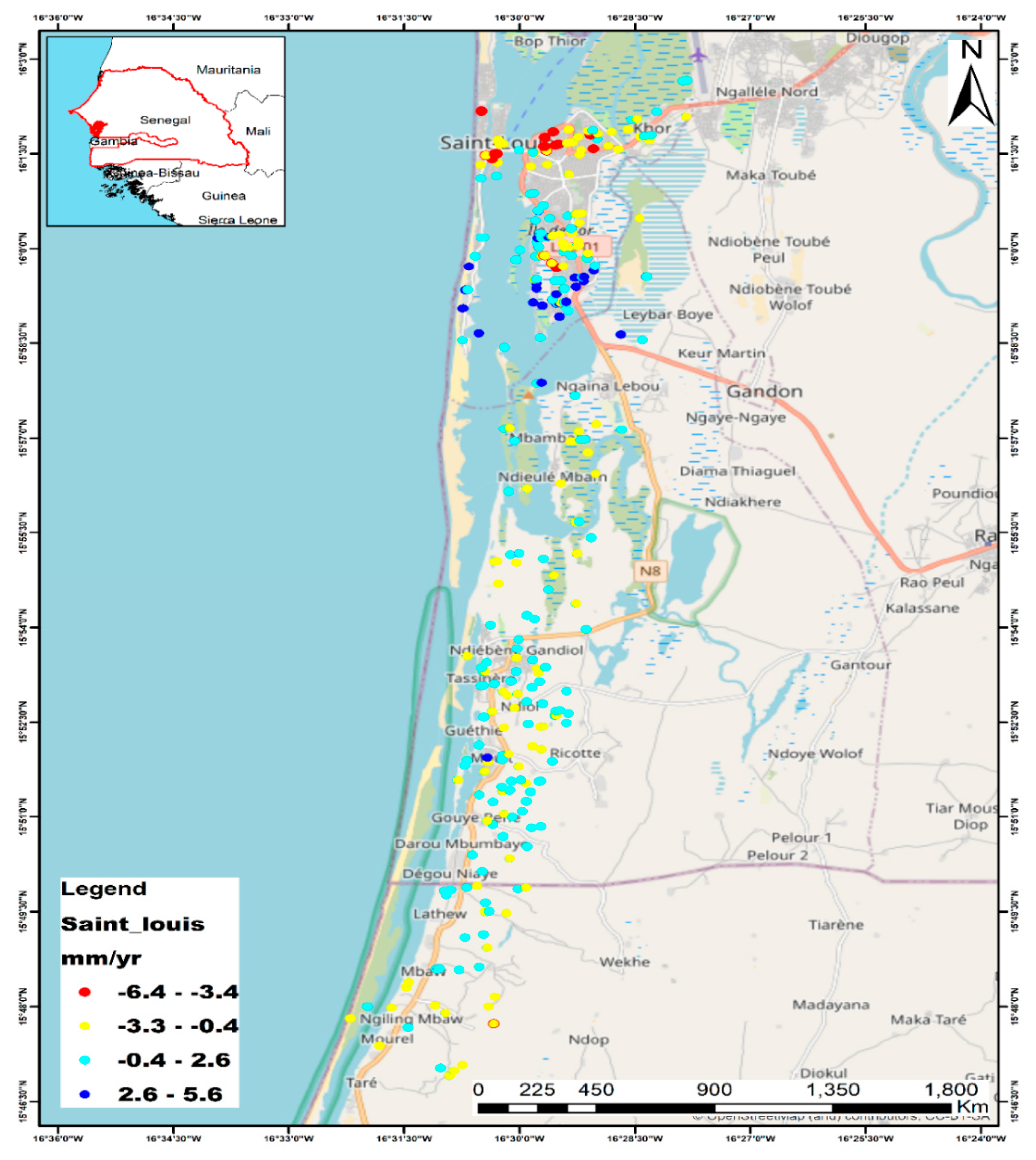
Figure 3.
Sea level rise and RSLR.
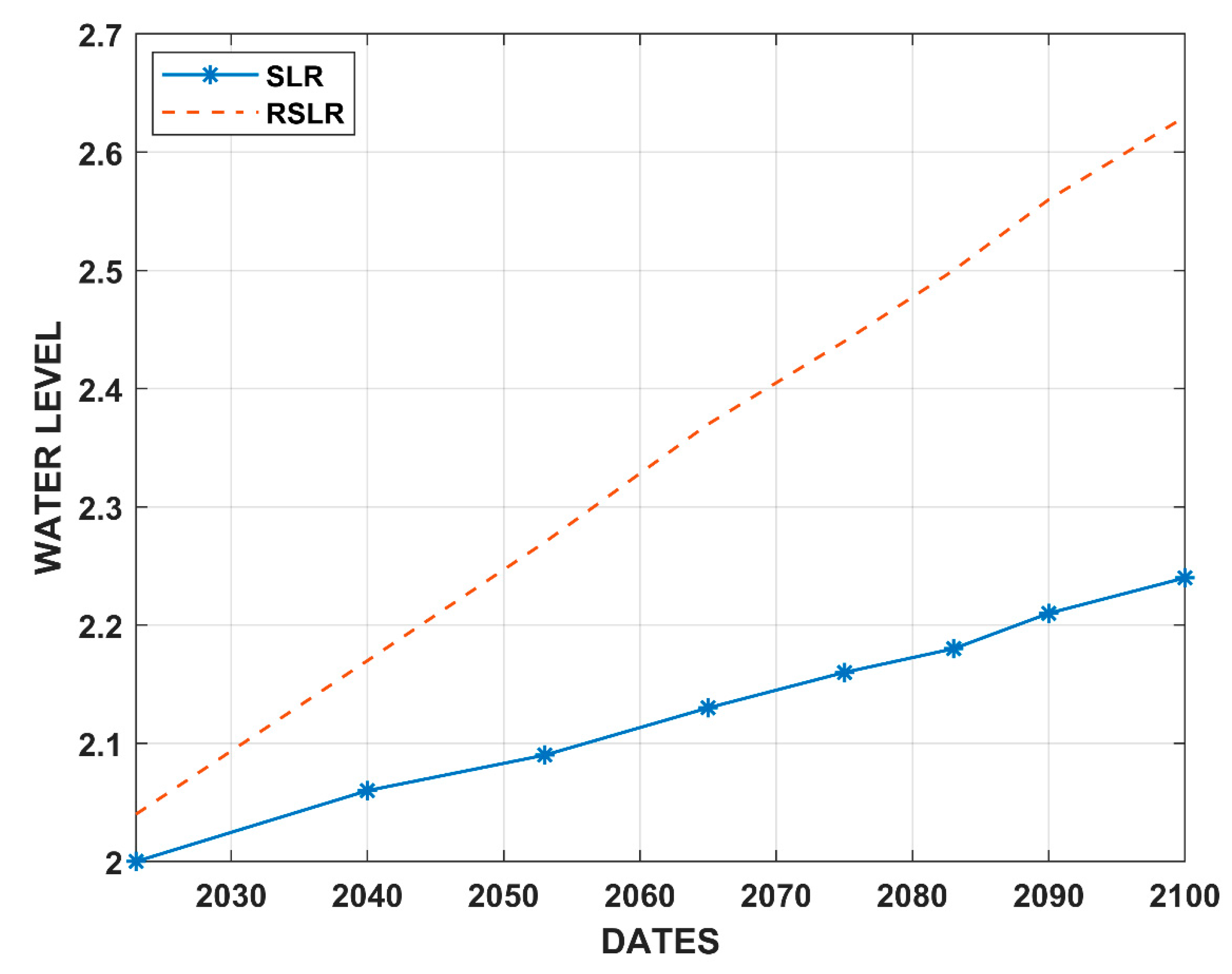
Figure 4.
Extent of coastal inundation due to subsidence and relative sea-level rise for RCP 2.6.
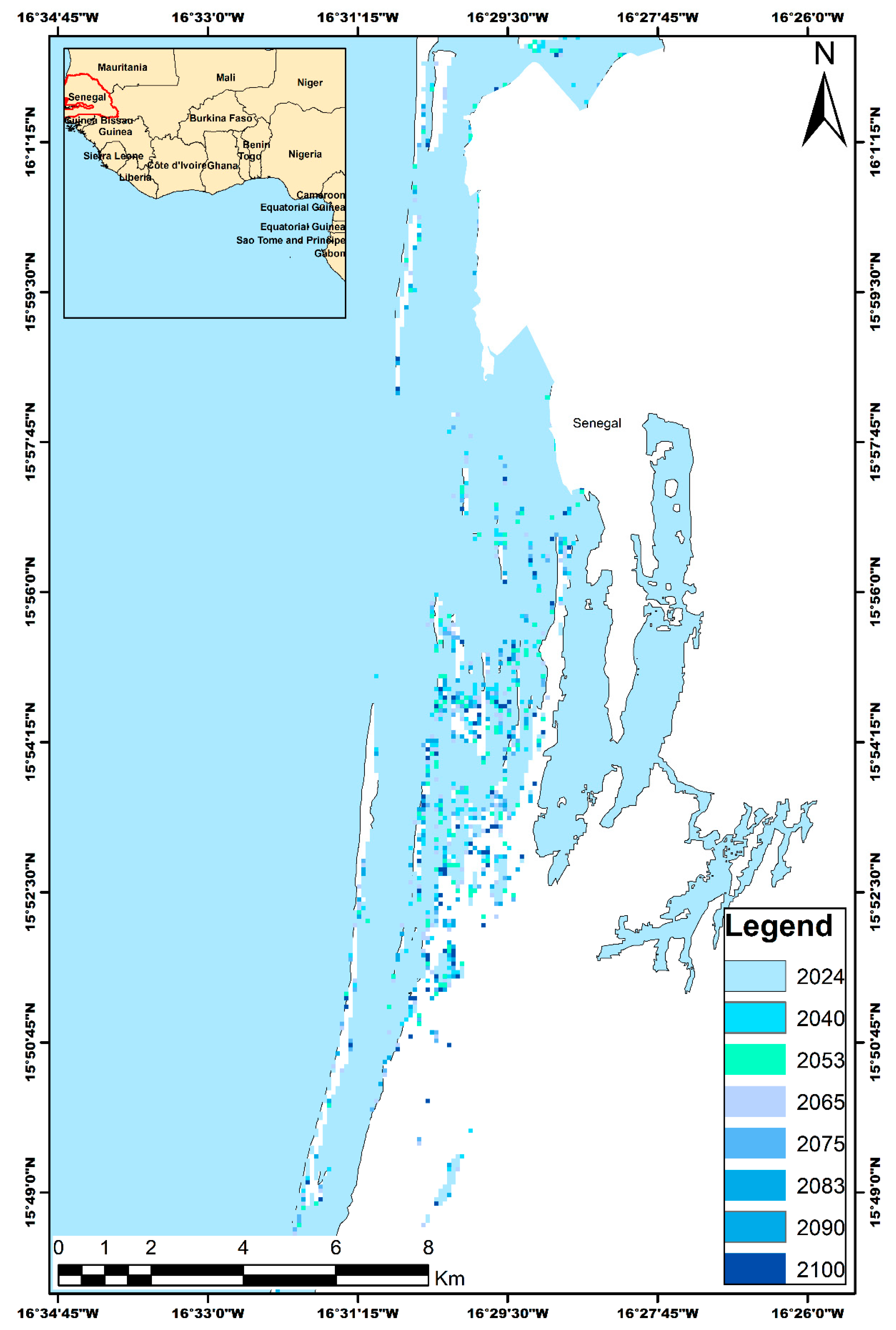
Figure 5.
Extent of flooded areas for RCP 2.6 and Percentage of increase in areas potentially flooded from 2024 to 2100.
Figure 5.
Extent of flooded areas for RCP 2.6 and Percentage of increase in areas potentially flooded from 2024 to 2100.
Disclaimer/Publisher’s Note: The statements, opinions and data contained in all publications are solely those of the individual author(s) and contributor(s) and not of MDPI and/or the editor(s). MDPI and/or the editor(s) disclaim responsibility for any injury to people or property resulting from any ideas, methods, instructions or products referred to in the content. |
© 2024 by the authors. Licensee MDPI, Basel, Switzerland. This article is an open access article distributed under the terms and conditions of the Creative Commons Attribution (CC BY) license (http://creativecommons.org/licenses/by/4.0/).
Copyright: This open access article is published under a Creative Commons CC BY 4.0 license, which permit the free download, distribution, and reuse, provided that the author and preprint are cited in any reuse.


