Submitted:
13 March 2024
Posted:
18 March 2024
You are already at the latest version
Abstract
Urban sprawl is recognized as one of the most critical drivers disrupting the functional integrity of rural and natural landscapes. A systematic multiscale study has yet to be conducted to measure the Megalopolis of Mexico City's regional extent, comprising ca. 23 million inhabitants. This paper investigates land cover, land use, vegetation and soil changes at macro-regional, regional, local and site scales. Land cover/use data from the 1970s and 2018 were used as the primary input to analyze changes using remote sensing and geographical information systems. At the local scale, fieldwork data from the 1970s, 1990s, and 2020 served as the primary input and were subjected to multivariate analyses. At site scale, soils profiles and hydrological balance analyses at micro-basin level were conducted. Furthermore, social perception of changes was investigated among local residents/stakeholders using semi-structured interviews with four communities. Outcomes were validated to reach 85 percent accuracy in cartographic and 95 % statistical outputs. At the regional scale, land-use changes, especially human settlements, increased from about four to almost 40 % between 1970 and 2018 , with significant incursion into rural landscapes. At the local scale, analyses revealed significant decline in predominantly cold-humid vegetation types and conversion of agricultural fields into peri-urban landscapes. Site scale revealed the predominant importance of soils as the core landscape component for water infiltration and carbon sequestration. Nested multi-scale analyses revealed different disrupting processes which are hidden at one scale and evident at another. Poorly implemented, disconnected urban and environmental policies prevail as the main driving force, with implications for the weak local governance of rural communities. Regional integrated analyses are discussed in light of the relevance of urban resilience theory.
Keywords:
Mexico City
; nested land cover trends
; landscape transformation
; social perception
; urban sprawl
1. Introduction
Urban sprawl has been recognized as a major driver disrupting the integrity of rural and natural ecosystems (Antrop, 2004; Lambin & Geist, 2006). Urban sprawl trends are typically irreversible, transforming rural and natural landscapes into human settlements (Brueckner, 2000). Most scientific attention has been centered upon economic, population, and infrastructure issues derived from urban encroachment, while limited research has investigated landscape degradation impact on surrounding environmental services (Musaoglu et al., 2005; Heistermann et al., 2006; Martínez-Zarzoso & Maruotti, 2011). Liu et al. (2022) highlighted the relevance of inserting urban resilience theory into regional studies.
Urban encroachment has multiple positive and negative impacts expressed at different scales. While many medical, educational, communicational, and economic services may be significantly improved by converting rural to urban landscapes, the incidence of criminal activities, quality of life, community integrity and environmental conditions are often negatively affected by urbanization. As urban sprawl expands, urgent efforts must be made to balance losses and gains, especially in regions where urbanization has exceeded landscape suitability and environmental services have been severely disrupted (Ernstson et al., 2010; Meerow et al., 2016).
There are many examples of cities overexploiting the essential resources that support them, such as water, food availability, and environmental ecosystem services that help to regulate climate. Cape Town, Lima, Shanghai, and Mexico City are some of the best-known current examples (Flint & Raco, 2012). Traditional approaches to studying urban impacts vary and outcomes are scale- and time-dependent. Multi(temporal)scale, macroregional, regional, and local analyses are therefore core requirements to understand environmental trends and consequences of urban encroachment (Slaymaker, 2001; Rudel et al., 2005). Several authors (Geist & Lambin, 2002; Veldkamp & Verburg, 2004; Willemen et al., 2012) have emphasized the need for such research to investigate proximate and underlying causes of urban encroachment. Multi(temporal)scale research into land cover, land use, and vegetation dynamics is fundamental for unraveling trends and identifying stakeholders that can help prevent the resulting irreversible loss of environmental services in rural/natural areas (Turner II et al., 1990; Velázquez et al., 2010). This research is significant in urban contexts where human access to essential resources may be threatened. For example, lack of food provision from neighbouring areas, air quality, and water availability are the most significantly compromised resources in most large conurbations (Villamar & Aguilar, 2020).
The Megalopolis of Mexico City (MMC), comprising the interconnected urban area of Mexico City and its surrounding human settlements, is one example where deteriorating environmental conditions have been experienced. Two core indicators are air quality and water availability (Molina & Molina, 2004; Jujnovsky et al., 2012). Its human population increased dramatically between 1980 and 2000 with growth continuing (Aguilar, 2008; Aguilart et al. 2022). Adding to the population densities of all its towns, it is estimated that the MMC currently contains around 23 million people. Determining the extent of urban sprawl is difficult because identifying city boundaries is challenging. If all surrounding human settlements are included, the population size may double, turning MMC into a Gigalopolis in size and connectivity (Schteingart, 1989; Aguilar, 2008).
Governance in such conditions is also challenging since the territorial configuration comprises multiple stakeholders. Despite their complex social, geographical and functional interaction, natural, rural, and urban landscapes in expanding cities such as the MMC have been researched independently despite their complex social, geographical, and functional interaction. The sustainability of any megalopolis depends largely on preventing disruption of these natural, rural, and urban landscapes. Hence, environmental and economic services/goods from these landscapes, such as water availability, agricultural products, and air quality, require analysis to maintain human living standards. Similarly, any threats jeopardizing such services/goods need a multiscale analysis. This type of research in a megalopolis setting is rare to our knowledge.
The research reported here set out to investigate major trends in the land cover change in the Megalopolis of Mexico City at macro-regional (covering the four main mountain ranges surrounding Mexico City and human settlements within), regional (Las Cruces and Chichinautzin mountain ranges and human settlements within), local (natural and rural remnants within Chichinautzin mountain range) and site (Tulmiac-Tlaloc micro-basin) geographical scales. Land cover data sets were used as the main input and integrated using GIS techniques. Understanding these changes was also complemented with semi-structured interviews conducted with members of four case study communities and key informants at local and regional scales.
2. Methods
2.1. Study Area
The Megalopolis of Mexico City (ca. 16,422 km2) is located east of the Transverse Volcanic Belt (TVB). The TVB is a region characterized by its geomorphology, geology, and biological features, with unique patterns of biodiversity and climatic variability (Velázquez & Romero, 1999; Heil et al., 2003). MMC is considered one of the fourth-largest cities in Latin America and the Caribbean (Aguilar & Graizbord, 2016) and the fifth-largest city in the world in 2018 (UN, 2018; Aguilar et al., 2022).
The MMC has experienced substantial urban expansion, encompassing the neighbouring cities of Toluca, Cuernavaca, and Puebla. Agricultural expansion and industrial infrastructure trigger various land-use change processes (Aguilar, 2008; Torres-Vera et al., 2009). Water provision is one of the region’s main challenges, relying upon exploiting regional and external water supplies. Indicators of critical water stress are evident within the region (Chen & Bilton, 2022; Cortes et al., 2020).
Three scales of GIS analysis were undertaken in this study, namely:
The macro-regional scale (1:250,000) comprised the Megalopolis of Mexico City (MMC), considered in this study as the functional spatial area which encompasses the metropolitan area of Mexico City and the metropolitan area of Toluca, as well as several towns of different sizes all of which are interconnected by road infrastructure. The MMC includes the basin of Mexico, encompassing the basins of Panuco, Lerma-Chapala, and Balsas, all surrounded by the Sierra Nevada, Nevado de Toluca, Sierra de Guadalupe, Sierra de las Cruces and Sierra Chichinautzin. The minimum area of one cartographic class that could be mapped at this geographic scale was considered accurate for polygons of 100 ha. Thus, polygons smaller than that were integrated into the surrounding matching land cover class polygon.
The regional-scale analysis (1:100,000) encompassed the Sierra de Chichinautzin, Sierra de las Cruces, and a surrounding buffer zone of 10 kilometers. The criteria delineating the Chichinautzin and Las Cruces ranges (INE, 2010) were predominantly natural land cover types, foot slopes and plains land forms, and the absence of large human settlements. The region covers 5,395 km2 (539,500 ha) and comprises the Sierra de Guadalupe, Sierra de las Cruces, and Sierra Chichinautzin. The minimum area that could be mapped at this geographic scale was considered accurate for polygons of 25 ha. Thus, polygons smaller than this were integrated with the surrounding polygon of matching land cover class.
The local scale analysis (1:50,000) encompassed the areas between the Tlaloc and Pelado volcanoes to the south of Mexico City. This area is representative of the native vegetation cover in the Sierra de Chichinautzin. It is a habitat for numerous endemic and critically endangered species (e.g., the volcano rabbit Romerolagus diazi and the Sierra Madre sparrow Xenospiza baileyi). The minimum area that could be mapped at this geographic scale was considered accurate for polygons of one hectare. Thus, polygons smaller than that were integrated into the surrounding matching land cover class polygon.
The site scale analysis (1:1000) was limited to the Tulmiac-Tlaloc micro-basin. The hydrological balance was carried out following methods used by Chow et al. 1994, within the Tulmiac-Tláloc micro-basin based on soil cover in the 1990s. As input, the soil map (scale 1:50,000) of the National Institute of Statistics and Geography of Mexico (INEGI, 1998) was used and information on vegetation and land use according to Velázquez (1994). For meteorological data, precipitation information from the “El Guarda” meteorological station of the National Water Commission for the last ten years (CONAGUA, 2009-2019) was considered. This analysis allows us to have a reference point with which to compare the results obtained from the continuous monitoring that began in 2019. Eight soil profiles were made to describe properties and to classify soil types and their infiltration, percolation and water and carbon storage capacity was performed following Siebe et al. (1996). Data on evaporation, transpiration and run off were obtained from the hydrological balance model, whereas data on water percolation, infiltration, carbon sequestration and water holding capability were obtained in situ in the soil profiles.
2.2. Database Integration
At the macro-regional scale, two Land Use/Cover Change (LUCC) databases were compiled for analysis. Cartographically, the vector input data used were for land use/land cover, scale 1:250,000 from the years 1976 and 2016. Both inputs were obtained from the National Institute of Statistics and Geography of México (INEGI, Series I and Series VI). The categories of land use/land cover were regrouped into two major cartographic classes, cultural and natural, as described by the Standardized Hierarchical Vegetation Classification SECLAVEMEX (Velázquez et al., 2016). The regrouped land cover classes were: 1. Natural (including native arboreal, shrubs, and grasslands) and 2. Cultural (cropland including forest plantations and urbanization).
At the regional scale analysis, two input data sets were used, namely: i) vector data from the National Institute of Geography and Statistics (INEGI) at a scale of 1:250,000 for the years 1976 (T1) and 2016 (T2) (INEGI, Series I and Series VI respectively) and ii) raster images from Sentinel 2 satellite (2018) of the European Space Agency (ESA). The former was ground-truthed using field data gathered by INEGI and a 1:50,000 scale land use/vegetation map from INEGI. The latter was submitted to an object-oriented classification process to enhance the visibility of changes in the extent of human settlements, and the reclassified image was downscaled by regrouping pixel size into 25 ha cartographic units. The categories of land use/land cover were regrouped following the Level 1 category from the Standardized Hierarchical Vegetation Classification SECLAVEMEX (Velázquez et al., 2016) and re-organized at a scale 1:100,000 (polygons greater than 25 ha). The final land cover classes mapped at this regional scale were: 1. Forest, 2. Native grassland and xerophytic scrubland, 3. Cropland, 4. Human settlements, and 5. Water bodies. The land cover change was calculated by comparing data for the two time periods (T1 and T2).
At the local scale, we used various datasets to carry out the analyses, including as baseline (T=0, the landscape ecology-vegetation data based on Velázquez (1993). These data offer the most comprehensive historical vegetation information for the area and include a map with 22 vegetation mapping units (Velazquez, 1993) and 159 relevés of phytosociological data.
A set of 109 aerial photographs from the 1970s (T1) scale 1:50,000 (INEGI) and a Sentinel 2 (January/February) satellite image from 2018 (T2) were used. All spatial data analyses and handling were done using ERDAS IMAGE 2014 and ArcView software. Using the landscape ecology-vegetation map as a baseline, the information was digitized and added to a Geographic Information System (GIS) as a source of information T=0. Regarding the other two sources of information, T1 and T2, a manual digital interpretation was carried out to detect changes (previous=T1 and subsequent=T2) on the borders of the landscape ecology-vegetation units (T=0). The features considered in the digital interpretations included texture, pattern, and colour. A field validation was carried out to make minor adjustments and verify complex units of T2. The hierarchical legend regrouped vegetation communities into four vegetation type classes: 1. Fir Forest, 2. Broad-leaved Forest, 3. Pine Forest, 4. Native grasslands, and 5. Agricultural fields. Ground-truthing was conducted in August 2019 to evaluate the output of the recent satellite imaging database. The other database, T=1, was checked against existing sources of information, such as reports from the National Forest Commission (CONAFOR for its Spanish acronym) and the phytosociological data of 1993 (Velázquez, 1993). Calculations of the dynamics of every vegetation cover type in each period were compiled (Figure 1).
2.3. Stakeholder Perceptions
Together with the land cover analysis, our objective was to understand the stakeholders’ perceptions of the patterns, processes, and consequences of land cover and land-use change from a series of 60 semi-structured interviews conducted with organizations and communities as part of the overall research program. This project component involved work with residents in four peri-urban agrarian centers within the Chichinautzin and Las Cruces ranges. Two settlements are on the southern fringes of Mexico City, and two are in adjacent municipalities of Morelos. We will not disclose settlement names for ethical reasons related to security concerns and sensitivities around land use. At community level, we undertook a total of 51 interviews across these sites, 12 of which were with community leaders and the remainder with a purposive sample of other citizens. The term ‘purposive’ denotes that we deliberately sought to identify selected individuals who had direct experience related to land use changes in the area over multiple decades, focusing mainly on people aged 40 and over. Such individuals were selected by consulting community leaders and, afterward, through successive recommendations by interviewees. It is difficult to eliminate bias in such a process. Still, the trade-off is that we could focus our limited resources rapidly by interviewing people with relevant knowledge rather than undertaking many redundant interviews if we had selected citizens at random. In addition, we undertook nine key informant interviews with individuals who were working or had worked within government organizations across the federal, state, and municipal levels. Following the initial analysis of the interview data, we undertook feedback and validation workshops in the four communities (with 8-10 attendees in each). One element of these interviews and workshops discussed people’s perceptions and perspectives on environmental change and its connections with livelihood practices, challenges, and trade-offs. The interactions included using maps (from satellite imagery) to discuss resources and land-use dynamics. Insights from these interview sources are incorporated into the Discussion section, adding experiential input to amplify and illustrate this paper's findings. To avoid academic extractivism, and as part of academic contributions to the public, we have committed with local communities to report back annually on our ongoing research via their general assemblies.
3. Results
3.1. Land Cover (Macro-Regional Scale 1:250,000)
The spatial land cover analysis of the MMC at the macro-regional scale is shown in Figure 2. The cultural land cover (urban and rural landscapes) for 1976 predominated, covering 63.56% (1,043,771 ha), while the natural cover type was 36.44% (598,397 ha). By 2016, the cultural land cover increased to 65.51% (1,075,784 ha), while the natural land cover decreased to 34.49% (566,384 ha). As noted in the cultural land cover, the human footprint in the macro-region was already substantial in the late 1970s.
3.2. Land Use (Regional Scale 1:100,000)
At the regional scale, the analysis focused on two areas: the predominantly natural land cover area, called bosque de agua (hereafter water forest sensu Hoth, 2012), and a 10 km buffer area where the main human activities occur. At this scale, we could map five land cover/use classes: native forest, native grassland and shrubland, crop (grazing) lands, human settlements, and water bodies.
Human settlements expanded dramatically from 4.35% (23,453 ha) in 1976 to 39.53% (213,277 ha) in 2018. Conversely, crop (grazing) lands diminished significantly from 43.42% (234,256 ha) in 1976 to 22.92% (123,657 ha) in 2018. Native forest and native grassland and shrubland also decreased from 43.40% (234,140 ha) to 33.24% (179,335 ha) and from 8.64% (46,592 ha) to 4.15% (22,369 ha), respectively. Water bodies were mapped as an independent class, yet their land cover dynamic at this scale was regarded as negligible (Figure 3).
The spatial expression of the native forest, native grassland and shrubland, crop (grazing) lands, human settlements, and water bodies revealed hidden information in the Macro-regional analysis. Human settlements expanded significantly to the west towards Toluca City. They also expanded to the south, towards Cuernavaca City, affecting mostly the foot slopes of the Sierra de las Cruces and Chichinautzin ranges. It is also worth mentioning that large human settlements were established on the upper parts of both ranges, mainly along highways and on plateaus. The overall results, including the 10 km buffer area, depict fragmented and disturbed native vegetation classes (Figure 4).
3.3. Vegetation Transitions at the Local Scale (1:50,000)
In the 1970s, the dominant vegetation type was broad-leaved forest, where the dominant tree genera were oak (Quercus), butterfly bush (Buddleia), alder (Alnus), wild strawberry tree (Arbutus) and pines (Pinus). Broad-leaved forest vegetation covered 38.05% (19,896 ha) of the whole area surveyed at the local scale. By 2018, broad-leaved forests expanded to cover 45.52% (23,800 ha), with different species compositions favoring human-induced species such as Alnus, while Quercus became rarely present. Agricultural fields, mainly of rain-fed traditional crops (Avena sativa, Opuntia streptacantha and Zea mays), covered 28.21% (14,749 ha) in the1970s, whilst also showing a slight expansion in 2018 to 29.33 % (15,334 ha). In 1970, the pine forest vegetation type (Pinus hartwegii, P. montezumae, P. pseudostrobus, and P. rudis) dominated at high elevations, covering 10.87% (5,684 ha). This vegetation type remained at a similar proportion by 2018, covering 11.15% (5,832 ha). The native herbland (grasslands) vegetation type, dominated by Festuca tolucensis and Muhlenbergia macroura species, followed a similar trend to the pine forest. During the 1970s, native herbland covered 10.15% (5,305 ha). It remained similar in 2018, covering 9.32% (4,873 ha) (Figure 5). The significant changes that occurred between 1970 and 2018 took place in the fir and cedar forest vegetation types (Abies religiosa and Cupressus lusitanica). In 1970, these covered 12.73% of the surveyed area (6,654 ha) whereas it had decreased to 4.69 % (2,451 ha) by 2018. Fir forest, a surrogate of the temperate humid ecosystem, has shrunk and fragmented the most. This fact contrasts with the broad-leaved forest, which has encroached significantly.
3.3. Site Scale: Changes in a Microwatershed, Water Balance and Monitoring Network (1:1000)
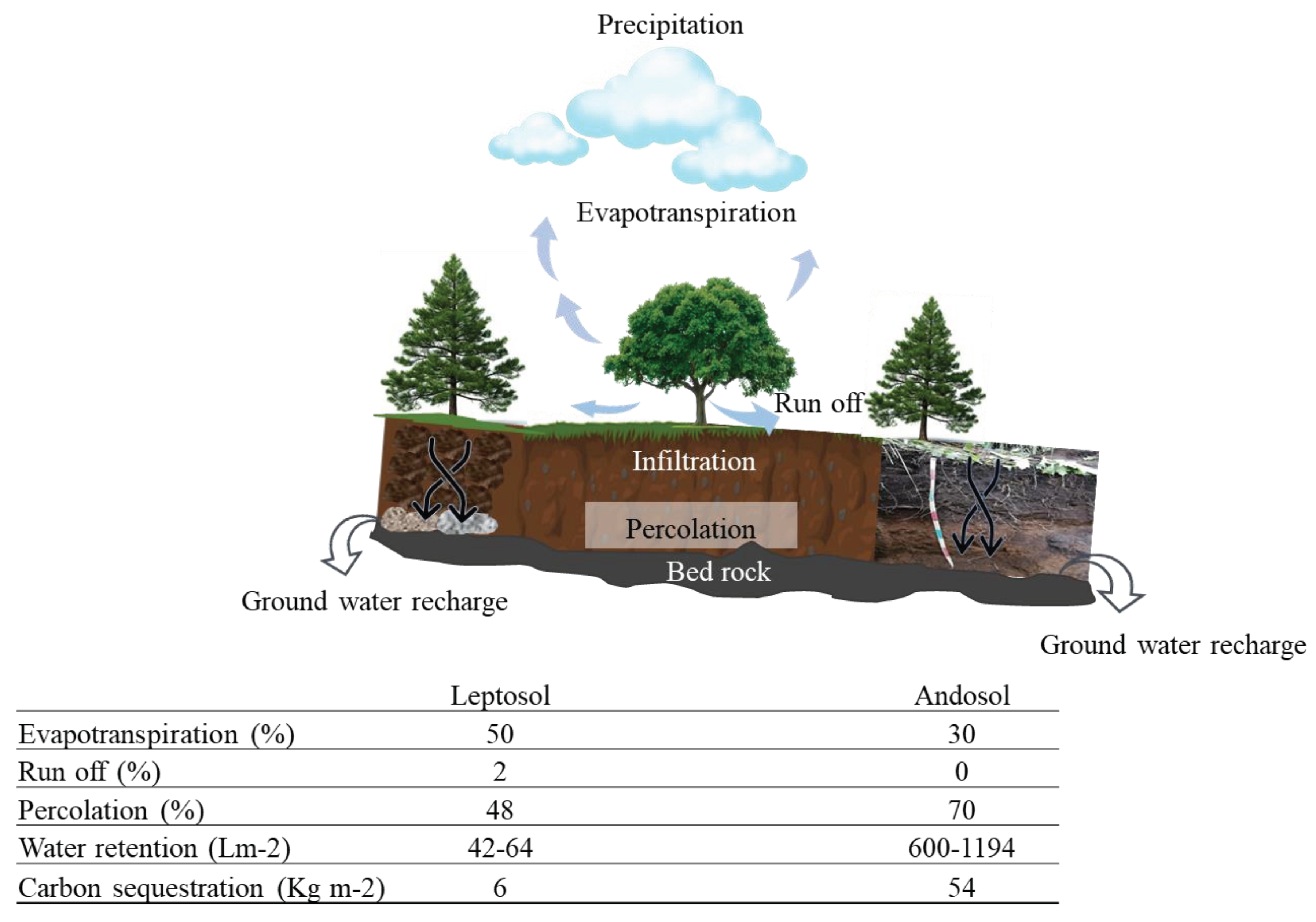
The results of this modeling indicate a high infiltration capacity of this basin’s soils of and reflect the potential for aquifer recharge and the ecosystem services provided. The results of the water balance model obtained are consistent with the hypothesis that the basin under study is an important recharge zone, since in all units, percolation (movement of water through the layers with different porosity) predominates and little runoff is observed (movement of water on the soil surface, lateral movement into the soil). A significant volume of soil water storage is estimated within the basin for a substantial part of the year, including during the dry season. The soil and weather station data were entered to the model, the results for each soil type are shown in Figure 6. Both Andosols and Leptosols have a high infiltration capacity, in both types of soil, much of the water that infiltrates into the soil. Once in the soil, water can be held against gravity and/or advance towards deeper strata (percolation) and recharge the aquifer. Andosols have a greater water retention and storage capacity than Leptosols (30 times more), and also provides more water for plants almost all year round (≈700 L m2 in Andosols vs 28 to 40 L m2 in Leptosols). In response, trees growing on Andosols have a greater cover, and greater annual growth in diameter (3.5 cm per year in the Andosol vs 2.36 cm per year in the Leptosol) and height (0.44 m per year in Andosol vs 0.31 m per year in Leptosol) and capture a greater amount of carbon in their aerial biomass. Andols store more carbon than Leptosols (up to 54 kg m2 in the Andosol vs 5-7 kg m-2 in the Leptosol) (Peña et al. 2009). It has to be bear in mind that water retention and carbon sequestration values are limited to the soil profiles studied.
4. Discussion and Conclusions
4.1. Macro-Regional Trends
At the macro-regional level (scale 1:250,000), during the 1976-2018 period surveyed in this study, around 34% of the surface of the study area remained predominantly natural, while 65% of the surface was classified as predominantly cultural/anthropogenic land cover types (human settlement, agriculture, and grassland under grazing). The 2.98% change over 40 years for the whole area has often been used as an indicator of low impact in the natural-cultural ratio of the whole region (Vega Guzmán et al. 2008). This outcome may be understood in terms of two complementary trends. On the one hand, by 1976, most of the macro-region was already dominated by urban and rural (crop/grassing lands) landscapes. On the other hand, in 1976, the total human population in the macro-region was 14 million. In contrast, by 2016, the human population had increased to 32 million for the whole macro-region. Thus, this gross scale analysis overlooked human population density and the increasing demand for environmental services. This gross scale hides functional processes that are threatening the macro-region environmental stability. Water bodies exemplify this trend well: by 2018, they had practically disappeared, disrupting water emission processes (Cram et al. 2008). However, at this scale, our study revealed that the Megalopolis of Mexico City is continuously growing, interconnecting other urban areas, sprawling rapidly and merging into the natural landscapes.
4.2. Regional Trends
Land-use changes in Sierra de las Cruces and Chichinautzin ranges (water forest area) and their surroundings revealed hidden trends overlooked while conducting land cover analyses at a gross scale (1:250,000). In contrast to native forest, grassland, and shrubland land-use types, which only reduced their surface area by about 14%, human settlement land-use type increased its surface about tenfold (from four to 39%). At this scale of analysis (approximately 1:100,000), we revealed that the urban landscape sprawled into crop/grazing lands, which were reduced by 52%. We named these changes a deruralization process, referred to as the trend of shrinking grazing and agricultural landscapes by urban expansion and afforestation processes.
In the last two decades, other environmental concerns associated with urbanization and increasing population have arisen in the region. Water quality and availability have become urgent issues threatening the region's sustainability. Water supply has been temporarily addressed for Mexico City residents by subsidizing the inflow arising from watersheds from the States of México and Michoacán. However, the long-term cost and increase in demand make this a short- to medium-term solution that can have unanticipated consequences for Mexico's Megalopolis and its continuing transformation. The research outcome at a regional level highlights the critical nature of ongoing land-use change processes. Turning farmland areas into urban sealed surfaces has drastically endangered the city's sustainability. The exact impact on water infiltration capacities is yet to be measured and is part of ongoing research. The role of natural and farmland areas that recharge the aquifers that supply most of the water to the Megalopolis of Mexico must be, in the meantime, properly protected to avoid critical situations as has happened in other large urban concentrations (Naik 2017).
4.3. Local and Site Trends
At the local scale, our study supported two main findings. The first is the conversion of native grasslands into agricultural fields in response to urban expansion onto agricultural land. The interviews in one settlement indicated that the areas the villagers once knew as covered with bunchgrass were now all transformed into crops and housing. The second outcome is the depletion and fragmentation of the fir forest vegetation into secondary broad-leaved forests. The former is regarded as a key indicator of cold-humid conditions (Velazquez & Cleff, 1993) once abundant in the area whilst the latter is directly linked to the ill-implemented reforestation efforts and illegal timbering. Inappropriate reforestation programmes and illegal timbering were corroborated during fieldwork observations. Fir forest areas in the past were either logged or reafforested with pines, alder, and exotic species. It is hereby inferred that illegal logging and the inappropriate reafforestation of the indirect Megalopolis thermal footprint actions are somehow related to the current endangered status of the fir forest communities in the area.
The present study is a contribution to the understanding of the environmental processes that currently occur in the region (infiltration) and the possible environmental implications resulting from the trends of change in land use in the region (dynamics of change) (Velázquez et al., 2010, FAO, 1996). Although there is still a need to expand research on infiltration processes to other areas such as the Sierra de las Cruces, with contrasting geological, geomorphological and soil features compared to the Sierra de Chichinautzin, this work provides a conceptual framework in the multi-scale and multi-temporal study to address the dynamics of rural landscapes and their impact on the environmental services provided by the region's landscapes.
Scientific research concerning the impact of land cover/use/vegetation change on ecosystem services is yet to be undertaken (Cram et al., 2008). However, biodiversity impoverishment, cross-pollination by native fauna, shifts from traditional oat agriculture into intensive, fertilizer-based potato cropping, and illegal logging are some of the most conspicuous proximal drivers of changes recorded during the study period.
These environmental changes directly affect the livelihoods and well-being of the highland communities and community-level resource governance. Among the people we interviewed, there existed a common perception of their landscape and environment in the past as being relatively unspoiled until the arrival of agrochemical use, increased urbanization and other changes from the 1960s onward. People often spoke about changes in vegetation and wildlife, water source degradation, water quality loss through pollution, reduced water supply through water table depletion, and restricted accessibility to communal water resources imposed by those who had acquired land. Pollution was a major concern, expressed as a direct threat to people’s wellbeing, and a reference point to general environmental degradation. Many people perceived that their formerly ‘clean’ environment had become rapidly polluted, reflected particularly in complaints about solid waste being dumped in ravines and in beliefs that rainwater running through the ravines and stored in reservoirs now carries toxic chemicals.
Perhaps the most concerning finding from fieldwork in communities and interviews with local organizations was the claim that many of the most environmentally-degrading activities are not effectively regulated (including illegal logging and hunting, soil extraction, and illegal fuel extraction)Encroachment of agrochemical-intensive potato cultivation by large agro-industrial businesses was also indicated as a growing threat. The deficit in enforcement of regulations was connected by many interviewees to the establishment of non-local organized crime organizations in some areas. The prolonged and growing presence of organized crime in Mexico has become a serious factor, creating a situation that borders on ungovernability in some settings.
The highland communities, including indigenous villages known as “pueblos originarios,” may play an important role as defenders of their natural and cultural legacy. Many of our interviewees expressed that they are willing to do their part to protect the natural resources associated with their environment. However, they are unlikely to take significant action without increased support from multi-stakeholder collaborations. Local informants documented two implications of the deruralization process during the interviews. The first implication is that indigenous groups’ traditional cropping systems have been largely extinguished. The second implication is that customary governance structures are being increasingly undermined by the merging of traditional and urban lifestyles. Even in communities where the land rights are still communally held, informal real estate markets are relatively common, often appropriating land for housing developments or commercial buildings.
At the local and site scales, socio-cultural drivers of land cover change are conspicuous and underline the region's challenge to contain urban encroachment and find economic compromises without disrupting the functional integrity of natural, rural, and urban landscapes. Institutional fragmentation and weak coordinating efforts are also part of this governance challenge. At the macro-regional scale, the jurisdictional complexity is illustrated by the fact that at least part of six states (Hidalgo, Tlaxcala, Puebla, Morelos, Ciudad de Mexico, and Estado de Mexico), 170 municipalities, and 1,169 rural communities lie within the Megalopolis of Mexico City. Civil servants that we interviewed pointed to inadequate collaboration between government bodies across municipal, state, and federal sectors, including competing mandates and differences in technical opinions on appropriate measures. There is a perception that the implementation and enforcement of measures to protect the local environment may adversely affect business and/or political interests to an extent that civil servants may face retaliation. Two more factors are closely related: a perception that a legal responsibility seldom exists to achieve environmental protection targets set within government plans (at municipal, state, and federal levels); and insufficient institutional incentives exist for civil servants to implement these programs and interventions.
At present, Mexico City cannot foster sound environmental policies to control urban sprawl. Results from the current environmental policies are negligible overall, as seen from the outcomes. However, this megalopolis of Mexico has not been completely unsuccessful in its environmental regulation, as shown by a joint initiative across states to mitigate the unbearable pollution from the 1980s. Results were significantly positive, and in just a decade, air pollution reached acceptance levels by international standards (Baumgardner et al., 2012). It would be fitting to see this joint effort reoriented towards containing urban encroachment, protecting the surrounding highland watersheds, and benefiting the macro-region depicted here.
5. Conclusions
Our results confirm that land cover trends and processes are scale- and time-dependent. The regional GIS results support the hypothesis of Geist and Lambin (2002), Veldkamp and Verburg (2004), Wassenaar et al. (2007), Rudel et al. (2005), Bray et al. (2008), Willemen et al. (2012), and Yang et al. (2013), who have argued that land cover/use studies must be undertaken at different times and scales to understand deeply proximal and underlying forces. This is especially crucial for urban resilience theory since the functional integrity of urban landscapes depend largely upon the environmental services of surrounding rural and natural landscape (Liu et al., 2022).
The multi-scale approach can help reveal different land cover, land use, and vegetation trends and their implications. Analyses at gross scales (macroregional [1:250,000] and regional [1:100,000]) are useful to draw large patterns of change and infer the core triggers of such changes. These scales are relevant in places where similar large urban centers have developed, especially in Western Europe, China (e.g., Shanghai and Beijing), and Latin America (e.g., Bogota, Colombia; Lima, Peru; La Paz, Bolivia). The multi-scale and multi-temporal land cover analysis that we present here, following Rudel et al. (2005), aided our understanding of current landscape trends and identified the conjoint causation of negative change in the study area. Hence, while satellite images for the region showed recovery at the local scale, ground-truthing indicated ecological impoverishment (Riemann, 2001). Judged from the satellite evidence, this type of change process is often considered positive (e.g., López et al., 2006) unless ground ecological verification is conducted (Velázquez et al., 2003; Briggs et al. 2007; Rodríguez et al., 2012). The local scale helped to identify complementary indicators of change and highlight likely socio-economic, political, and cultural triggers of landscape disruption, as well as opportunities for sustainable development. Urban encroachment impacts in the “Gigalopolis of Central Mexico” have multiple local, regional, and global implications. Remote sensing images and maps are sources to help build one reality, whereas local and stakeholder perceptions are another overlapping reality. The research team continues to communicate the analysis progress with local communities in general assemblies and specific meetings to bridge local perceptions with the perceptions of government authorities.
We contend that, in addressing this topic, it is essential to take a transdisciplinary territorial approach (Sarquís & Torio, 2009). Such an approach helps us to share government, academic, and local institutions’ realities, to create the type of mutual understanding that can generate compromise, and to turn present worldwide urban encroachment trends into sustainable human-environment relationships. The triggers to promote collective action to this end need to be both better understood and enabled (Sosa et al., 2023).
Acknowledgments
This study was funded by the British Academy through the University of East Anglia project (C&I 2017: UEA-UNAM 52816-1876-12-VI-18) and by the Universidad Nacional Autónoma de México (DGAPA-UNAM IN105721). We thank Jurgen Hoth (at the time working for Conservación Internacional México) for providing conceptual insight, participating in funding acquisition and fieldwork validation, and reviewing an early version of the present manuscript. Diego Reygadas, Claudia Galicia, and Oscar Alvarez were core research assistants in this project. Special acknowledgments to the participating agrarian communities (Topilejo, San Salvador, and Milpa Alta), Mexico City Government, and its local institutions (Secretaria del Medio Ambiente and Comisión de Recursos de Naturales y Desarrollo Rural). Ana Perusquia reviewed a version of the present manuscript.
Declarations of interest
None.
References
- Antrop, M. Landscape change and the urbanization process in Europe. Landsc Urban Plan 2004, 67, 9–26. [Google Scholar] [CrossRef]
- Aguilar, A.G. Peri-urbanization, illegal settlements, and environmental impact in Mexico City. Cities 2008, 25, 133–145. [Google Scholar] [CrossRef]
- Aguilar, A.G.; Graizbord, B. Ciudad de México: megalópolis o ciudad-región. In Aguilar, G. (Ed.), La Ciudad de México en el siglo XXI: realidades y retos. (pp. 753-764). Gobierno de la Ciudad de México, Secretaría de Ciencia, Tecnología e Innovación. 2016.
- Baumgardner, D.; Varela, S.; Escobedo, F.J.; Chacalo, A.; Ochoa, C. The role of a peri-urban forest on air quality improvement in the Mexico City megalopolis. Env Pollut 2012, 163, 174–183. [Google Scholar] [CrossRef]
- Aguilar, A. G.; Flores, M. A.; Lara, L. F. Peri-urbanization and land use fragmentation in Mexico City. Informality, environmental deterioration, and ineffective urban policy. Frontiers in Sustainable Cities 2022, 4, 790474. [Google Scholar] [CrossRef]
- Brueckner, J.K. Urban sprawl: diagnosis and remedies. Intern Reg Sci Rev 2000, 23, 160–171. [Google Scholar] [CrossRef]
- Bray, D.B.; Duran, E.; Ramos, V.H.; Mas, J.F.; Velázquez, A.; Balas McNab, R.; Barry, D.; Radachowsky, J. Tropical deforestation, community forests, and protected areas in the Maya Forest. Ecol Soc 2008, 13, 56. Available online: http://www.ecologyandsociety.org/vol13/iss2/art56/ (accessed on 4 February 2021). [CrossRef]
- Briggs, J.M.; Schaafsma, H.; Trenkov, D. Woody vegetation expansion in a desert grassland: Prehistoric human impact? J Arid Env 2007, 69, 458–472. [Google Scholar] [CrossRef]
- Chen, Y.; Bilton, A. Water stress, peri-urbanization, and community-based water systems: A reflective commentary on the metropolitan area of Mexico City. Frontiers in Sustainable Cities. 2022, 4, 1–10. [Google Scholar] [CrossRef]
- Cortés, F.A.; Saavedra-Horita, J.; Rodriguez-Varela, J.M.; Tzatchkov, V.G.; Cortez-Mejia, P.E.; Llaguno-Guilberto, O.J.; Sainos-Candelario, A. State level water security indices in Mexico. Sustainable Earth 2020, 3. [Google Scholar] [CrossRef]
- Cram, S.; Cotler, H.; Morales, L.M.; Sommer, I.; Carmona, E. Identificación de los servicios ambientales potenciales de los suelos en el paisaje urbano del Distrito Federal. Investig Geogr 2008, 66, 81–104. [Google Scholar]
- CNA. Agenda 2030, avances y logros 2012. Secretaría de Medio Ambiente y Recursos Naturales Comisión Nacional del Agua. 2012.
- Ernstson, H.; Van der Leeuw, S.E.; Redman, C.L.; Meffert, D.J.; Davis, G.; Alfsen, C.; Elmqvist, T. Urban transitions: on urban resilience and human-dominated ecosystems. Ambio 2010, 39, 531–545. [Google Scholar] [CrossRef] [PubMed]
- Flint, J.; Raco, M. (Eds.) . The future of sustainable cities: Critical reflections. Bristol University Press. 2012. [CrossRef]
- Geist, H.J.; Lambin, E.F. Proximate causes and underlying driving forces of tropical deforestation. BioSci 2002, 52, 143–150. [Google Scholar] [CrossRef]
- Heil, G.W.; Bobbink, R.; Boix, N.T. (Eds). Ecology and man in Mexico’s central volcanoes area. Springer Science and Business Media. 2003.
- Heistermann, M.; Müller, C.; Ronneberger, K. Land in sight? Achievements, deficits, and potentials of continental to global scale land-use modeling. Agric Ecosyst Env 2006, 114, 141–158. [Google Scholar] [CrossRef]
- Hoth, J. (Ed). Estrategia regional para la conservación del bosque de agua 2012-2030. Fundación Gonzalo Río Arronte, I.A.P.; Fundación Biósfera del Anáhuac, A.C. y Pronatura México, A.C. 2012.
- INE. Propuesta para la gestión del bosque de agua como región prioritaria de conservación. Documento de trabajo. Instituto Nacional de Ecología. 2010.
- Jujnovsky, J.; González-Martínez, T.M.; Cantoral-Uriza, E.A.; Almeida-Leñero, L. Assessment of water supply as an ecosystem service in a rural-urban watershed in southwestern Mexico City. Environ Manag 2012, 49, 690–702. [Google Scholar] [CrossRef]
- Lambin, E.F.; Geist, H.J. (Eds.) Springer. 2002.
- Liu, Y.; Li, Q.; Li, W.; Zhang, Y.; Pei, X. Progress in urban resilience research and hotspot analysis: a global scientometric visualization analysis using CiteSpace. Environmental Science and Pollution Research 2022, 1–18. [Google Scholar] [CrossRef]
- López, E.; Bocco, G.; Mendoza, M.; Velázquez, A.; Aguirre-Rivera, J.R. Peasant emigration and land-use change at the watershed level. A GIS-based approach in Central Mexico. Agric Sys 2006, 90, 62–78. [Google Scholar] [CrossRef]
- Martínez-Zarzoso, I.; Maruotti, A. The impact of urbanization on CO2 emissions: evidence from developing countries. Ecol Econ 2011, 70, 1344–1353. [Google Scholar] [CrossRef]
- Meerow, S.; Newell, J.P.; Stults, M. Defining urban resilience: A review. Landsc Urban Plan 2016, 147, 38–49. [Google Scholar] [CrossRef]
- Molina, L.T.; Molina, M.J. Improving air quality in megacities: Mexico City case study. Ann NY Acad Sci 2004, 1023, 142–158. [Google Scholar] [CrossRef]
- Musaoglu, N.; Tanik, A.; Kocabas, V. Identification of land-cover changes through image processing and associated impacts on water reservoir conditions. Environ Manag 2005, 35, 220–230. [Google Scholar] [CrossRef]
- Naik, P.K. The water crisis in Africa: myth or reality? International journal of water resources development, 2017, 33, 326–339. [Google Scholar] [CrossRef]
- Ostrom, E. Collective action and the evolution of social norms. J Appl Econ 2000, 14, 137–158. [Google Scholar] [CrossRef]
- Riemann, H. Flora vascular endémica de la Península de Baja California, patrones de distribución y escenarios de conservación, Dissertation. Universidad Nacional Autónoma de México. 2001. https://ru.dgb.unam.mx/handle/DGB_UNAM/TES01000298160. 0100.
- Rodríguez-Eraso, N.; Armenteras-Pascual, D.; Retana-Alumbreros, J. Land use and land cover change in the Colombian Andes: dynamics and future scenarios. J Land Use Sci 2012, 8, 154–174. [Google Scholar] [CrossRef]
- Rudel, T.K.; Coomes, O.T.; Moran, E.; Achard, F.; Angelsen, A.; Xu, J.; Lambin, E. Forest transitions: Towards a global understanding of land use change. Glob Environ Chang 2005, 15, 23–31. [Google Scholar] [CrossRef]
- Sarquís, D.J.; Torio, J.B. La teoría del conocimiento transdisciplinar a partir del Manifiesto de Basarab Nicolescu. Fundamentos en Humanidades 2009, 19, 43–55. [Google Scholar]
- Siebe, C.; Jahn, R.; Stahr, K. Manual para la descripción y evaluación ecológica de suelos en el campo. Publicación. Ed. Chapingo, México. 1996.
- Sosa, N.; Torres, A.; Castro-Lopez, V.; Velazquez, A. Participatory Landscape Conservation: A Case Study of a Seasonally Dry Tropical Forest in Michoacan, Mexico. Land, 12(11), 2016.Slaymaker, O. (2001). Why so much concern about climate change and so little attention to land use change? Can Geogr 2023, 45, 71–78. [Google Scholar] [CrossRef]
- Schteingart, M. The environmental problems associated with urban development in Mexico City. Environ Urban 1989, 1, 40–50. [Google Scholar] [CrossRef]
- Torres-Vera, M.A.; Prol-Ledesm, R.M.; Garcia-Lopez, D. Three decades of land use variations in Mexico City. Int J Remote Sens 2009, 30, 117–138. [Google Scholar] [CrossRef]
- Tortajada, C. Water management in Mexico City metropolitan area. Int J Water Resour Dev 2006, 22, 353–376. [Google Scholar] [CrossRef]
- Turner II, B.L.; Clark, W.C.; Kates, R.W.; Richards, J.F.; Mathews, J.T. (Eds). The earth as transformed by human action: global and regional changes in the biosphere over the past 300 years. Cambridge University Press. 1990.
- United Nations, Department of Economic and Social Affairs, Population Division. World Urbanization Prospects. 2018.
- Vega Guzmán, Á.; López-García, J.; Manzo Delgado, L.D.L. Spectral and visual analysis of vegetation and land use with Landsat ETM+ images assessed by digital aerial photography of the Chichinautzin Biological Corridor, Morelos, Mexico. Investigaciones Geográficas 2008, 67, 59–75. [Google Scholar]
- Velázquez, A. Landscape vegetation ecology of Tlaloc and Pelado volcanoes, Mexico. ITC Publications 1993, 16. [Google Scholar]
- Velázquez, A.; Cleef, A. The plant communities of the volcanoes. Phytocoenologia 1993, 1993, 145–191. [Google Scholar] [CrossRef]
- Velázquez, A.; Romero, F. Biodiversidad de la región de montaña del sur de la cuenca de México. UAM. 1999.
- Velázquez, A.; Durán, E.; Ramírez, I.; Mas, J.F.; Bocco, G.; Ramírez, G.; Palacio, J.L. Land-use cover change processes in highly biodiverse areas: the case of Oaxaca, Mexico. Glob Environ Chang 2003, 13, 175–184. [Google Scholar] [CrossRef]
- Velázquez, A.; Mas, J.F.; Bocco, G.; Palacio-Prieto, J.L. Mapping land cover changes in Mexico, 1976-2000 and applications for guiding environmental management policy. Singap J Trop Geogr 2010, 31, 152–162. [Google Scholar] [CrossRef]
- Velázquez, A.; Medina-García, C.; Durán-Medina, E.; Amador, A.; Gopar-Merino, L.F. Standardized hierarchical vegetation classification. Mexican and global patterns. Springer Nature. 2016.
- Veldkamp, A.; Verburg, P.H. Modelling land use change and environmental impact. J Environ Manag 2004, 72, 1–3. [Google Scholar] [CrossRef]
- Villamar, I.; Aguilar, A.G. Deterioro ambiental y ocupación urbana irregular en la zona lacustre de Xochimilco, Ciudad de México. J Lat Am Geogr 2020, 19, 43–67. [Google Scholar] [CrossRef]
- Wassenaar, T.; Gerber, P.; Verburg, P.H.; Rosales, M.; Ibrahim, M.; Steinfeld, H. Projecting land-use changes in the Neotropics: The geography of pasture expansion into forest. Glob Environ Chang 2007, 17, 86–104. [Google Scholar] [CrossRef]
- Willemen, L.; Veldkamp, A.; Verburg, P.H.; Hein, L.; Leemans, R. A multi-scale modeling approach for analyzing landscape service dynamics. J Environ Manag 2012, 100, 86–95. [Google Scholar] [CrossRef] [PubMed]
- Yang, L.; Homer, C.; Brock, J.; Fry, J. An efficient method for change detection of soil, vegetation, and water in the Northern Gulf of Mexico wetland ecosystem. Int J Remote Sens 2013, 34, 6321–6336. [Google Scholar] [CrossRef]
Figure 1.
Methodological flowchart describing the spatial and temporal scales of analysis performed for the present research.
Figure 1.
Methodological flowchart describing the spatial and temporal scales of analysis performed for the present research.
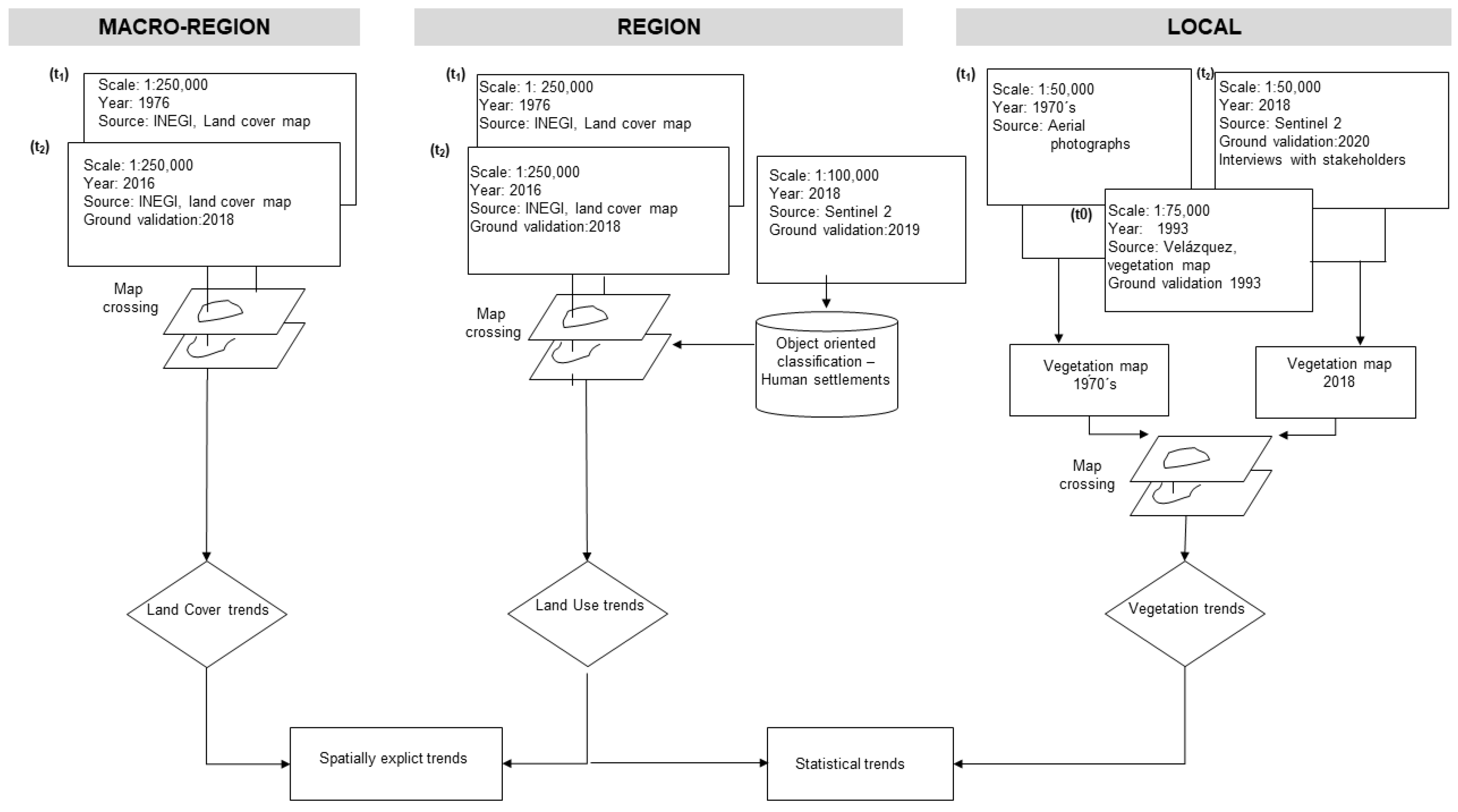
Figure 2.
Spatial distribution of land cover classes at macro-regional scale for 1976 and 2016. Grey areas merge predominantly urban and rural landscapes, whereas green depicts predominantly natural landscapes. Water bodies intermingle within urban and rural landscapes. These are negligible at this scale, so they are merged into the grey category.
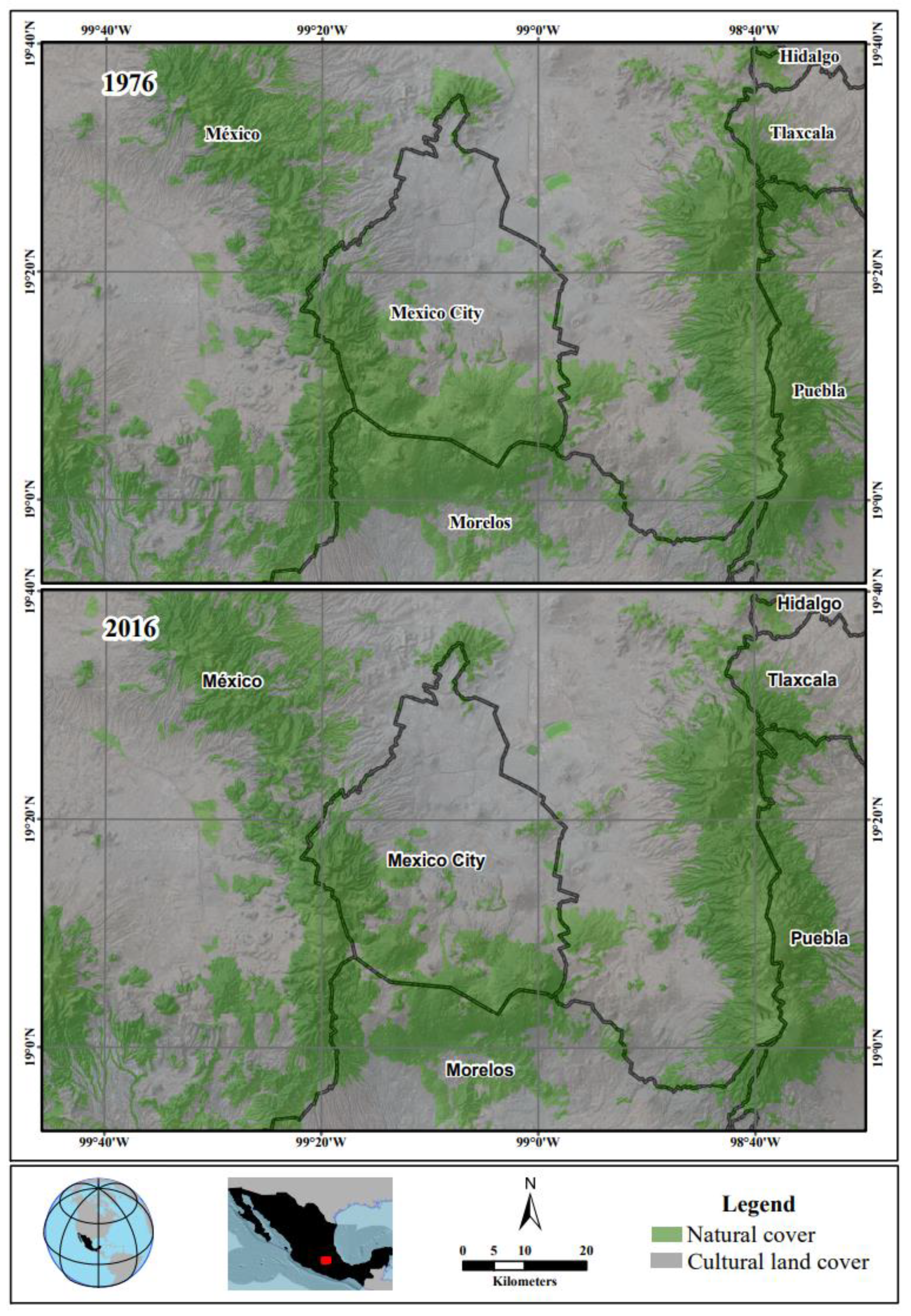
Figure 3.
Percentage of land cover/use types of the regional area between 1976 (grey bars) and 2018 (black bars). Human settlements were the landcover/use type that most expanded onto the remaining classes.
Figure 3.
Percentage of land cover/use types of the regional area between 1976 (grey bars) and 2018 (black bars). Human settlements were the landcover/use type that most expanded onto the remaining classes.
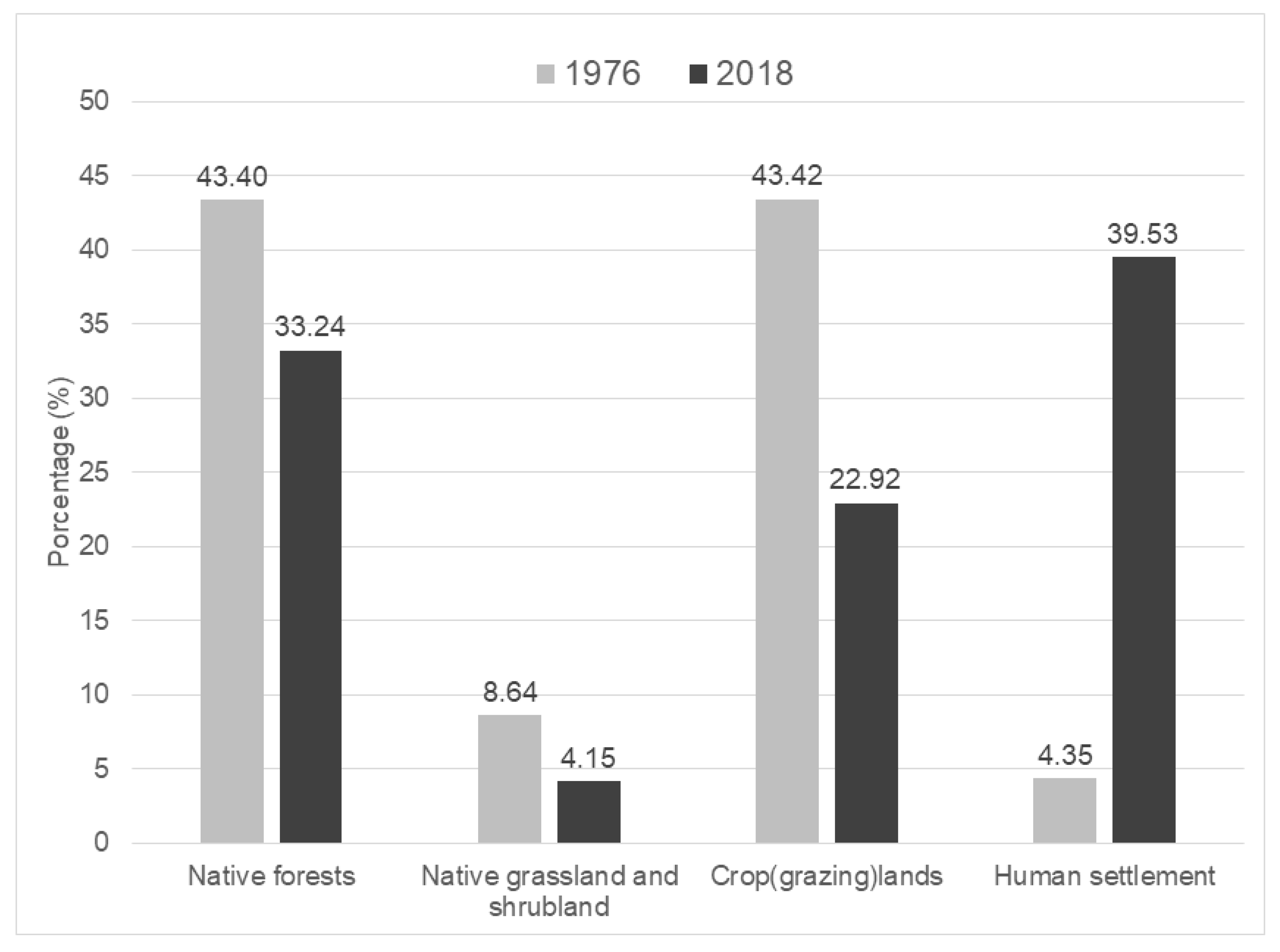
Figure 4.
Spatial distribution of land cover use classes at regional scale for 1976 and 2018. The blue line border refers to the water forest region. The black line is the 10 km border buffer zone. Water bodies by 1976, in the vast majority, were not perennial but seasonal in years with low precipitation regimes.
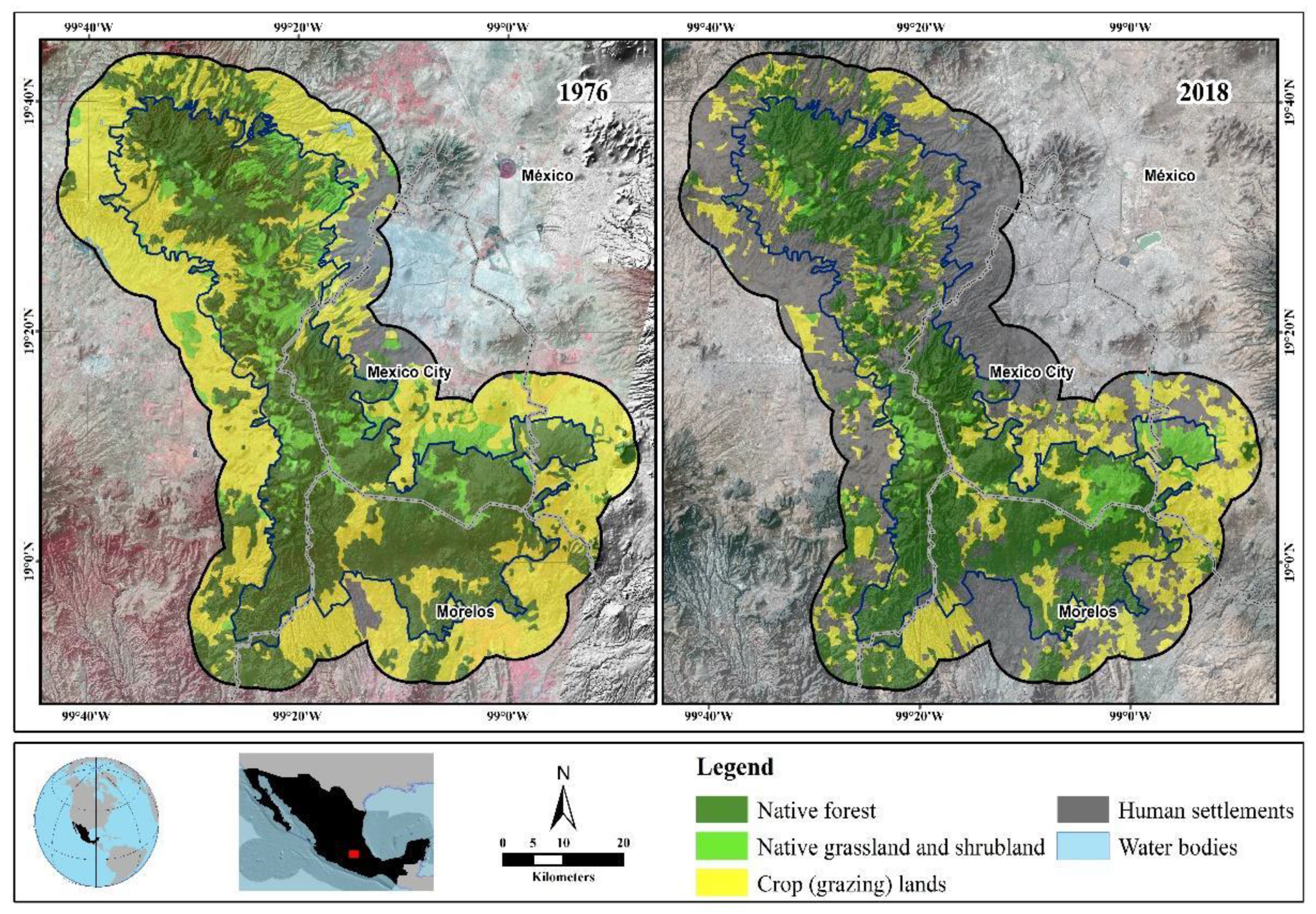
Figure 5.
Percentage of vegetation types at the local scale between 1976 (grey bars) and 2018 (black bars).
Figure 5.
Percentage of vegetation types at the local scale between 1976 (grey bars) and 2018 (black bars).
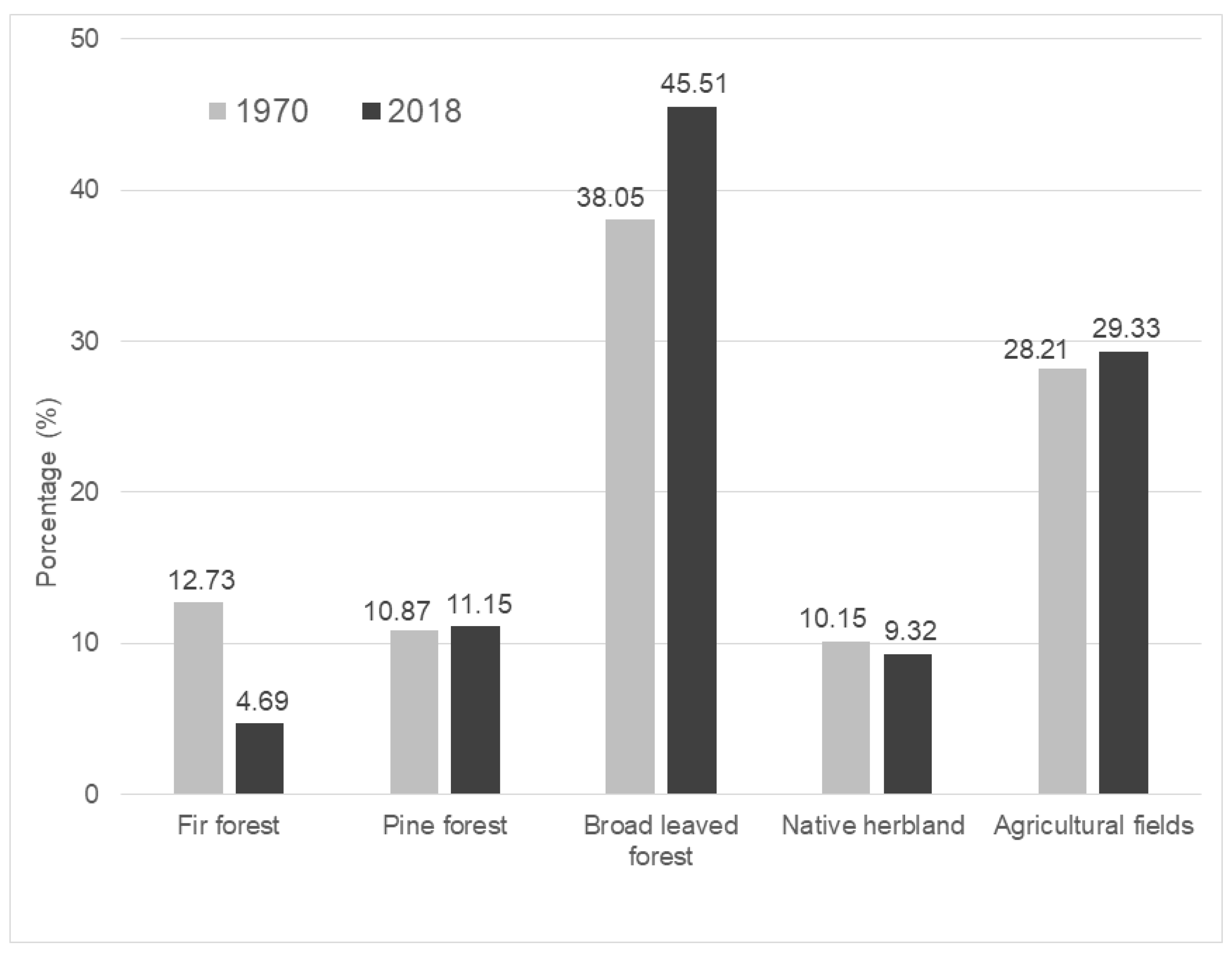
Figure 6.
Results of the water balance model of the Tulmiac-Tlaloc sub-basin and soil profile analyses. The values of percolation, surface runoff and evapotranspiration are indicated for each type of soil studied.
Figure 6.
Results of the water balance model of the Tulmiac-Tlaloc sub-basin and soil profile analyses. The values of percolation, surface runoff and evapotranspiration are indicated for each type of soil studied.
Disclaimer/Publisher’s Note: The statements, opinions and data contained in all publications are solely those of the individual author(s) and contributor(s) and not of MDPI and/or the editor(s). MDPI and/or the editor(s) disclaim responsibility for any injury to people or property resulting from any ideas, methods, instructions or products referred to in the content. |
© 2024 by the authors. Licensee MDPI, Basel, Switzerland. This article is an open access article distributed under the terms and conditions of the Creative Commons Attribution (CC BY) license (http://creativecommons.org/licenses/by/4.0/).
Copyright: This open access article is published under a Creative Commons CC BY 4.0 license, which permit the free download, distribution, and reuse, provided that the author and preprint are cited in any reuse.


