
Submitted:
06 March 2024
Posted:
07 March 2024
You are already at the latest version
Abstract
In this paper, we studied the problem of early detection of natural phenomena associated with the formation of severe floods and the possibility of constant monitoring of their occurrence. The test object for the study was severe floods on the Crimean Peninsula, which occurred due to heavy rainfall in the summer of 2021. Based on the selected satellite and other data related to this period, an analysis carried out and key atmospheric objects identified, according to the proposed algorithm for their identification and grouping. Based on the results of the work, a positive conclusion made on the issue of their use to identify the likelihood of natural disasters that could lead to floods. In addition, the authors proposed to develop a portal for collecting and processing a large amount of satellite data related to flood prevention and monitoring the development of such processes, and stressed the need to create it.
Keywords:
floods
; climate study
; Meteosat satellites
; data visualization
; remote sensing
; satellite sensing.
Introduction
Currently, with the increasing number of natural disasters, the task of operational monitoring and assessment of their consequences is becoming more relevant. The priority issue is to study the conditions for the occurrence of floods, which cause significant damage to human life. In recent years, the field of studying flood forecasting using remote sensing data in combination with information obtained from other sources has been actively developing. Remote sensing can provide sufficient information for flood management systems. Recent literature has explored methods from several related disciplines, including image processing, machine learning, and data mining, to manage various flood management tasks [1]. A classification system has been proposed by several authors that divides remote sensing technologies used for flood forecasting into three types: multispectral, radar and light detection and ranging (LIDAR). Each of them has its own advantages and limitations [2]. Also, due to the growing volume of satellite data and the impossibility of their manual processing in real time, the importance of using the latest technologies, such as, for example, automated machine learning algorithms for more accurate and timely identification and mapping of emerging natural disasters [3].
In this work was investigated the flood that occurred in Crimea in the summer of 2021, which caused damage in the eastern and central regions of the peninsula. This was one of the cases of a series of floods that occurred during this period on the Black Sea coast of Russia [4,5]. The Black Sea region is often subject to natural disasters, and their study is becoming increasingly necessary for their timely detection. The work used information received from the European Organization for Satellite Meteorology (EUMETSAT), which was available for download through their official website (subsection with the address https://archive.eumetsat.int/). The information obtained from processed data from Meteosat Second Generation (MSG) satellites. The availability, volume and quality of this data make this satellite suitable for a variety of studies [6,7].
The work explored the possibility of identifying flood conditions using MSG satellite data. The availability of data for a specific period and territory (the Crimean Peninsula and adjacent waters of the Azov and Black Seas) checked, and a process for their processing developed using software in the Java programming language to study and possibly compile an operational picture of the occurrence of floods. The processed information related to the June 2021 flood in Crimea was analyzed and its compatibility with other types of data. The process of obtaining and processing remote sensing data also described.
Initial Data for the Study
Satellite data presented on the portal in processed form as information products that display one or another atmospheric parameter. They are available with high frequency, which makes it possible to conduct effective observations of the desired processes. The selected data based on the information of a satellite with a coverage area the Indian Ocean region (MSG Indian Ocean 41.5 degrees E [8]), whose coverage area also includes the entire northern Black Sea region. The geostationary orbit of the Meteosat satellite allows monitoring of the selected area around the clock, maintaining the viewing angle, which can significantly simplify the work of automated data systems, increasing their efficiency and accuracy.
To conduct the study, two types of data selected; their order and subsequent downloading carried out. The received data presented in the GRIB (GRIdded Binary) format — a mathematical format used for storing and transmitting meteorological data between computer systems, as well as in the JPEG raster format for monitoring and visually displaying the downloaded data.
Cloud Mask is an auxiliary parameter selected to identify a correlation to check the information content of the first parameter. Classifies each atmospheric pixel as one of the following four types: clear sky over land, clear sky over water, cloudy zone, or unrecognized (usually a pixel corresponding to a point outside the Earth’s disk) [8].
Multi-Sensor Precipitation Estimate includes real-time rainfall rates in mm/hour for each Meteosat image at native pixel resolution. The algorithm for generating these values based on a combination of polar orbiter microwave measurements and Meteosat infrared images using a blending method [8]. Rainfall is one of the key parameters for identifying possible floods.
As additional sources of information during the work, information was used from the information portals of the Ministry of the Russian Federation for Civil Defense, Emergencies and Disaster Relief (EMERCOM of the Russian Federation) [5] and the Crimean Department of Hydrometeorology and Monitoring (Crimean UGMS) [4]. Using these data, the periods of heavy rains in the region that caused floods verified and clarified, which used to select the period for downloading satellite data, as well as subsequently to verify the information obtained during the work. Intense precipitation observed on June 16 and 17, as well as on June 21 and 22; during this period, the bulk of the precipitation fell, which caused severe flooding in the region. Based on this, it was decided to set the study period from midnight June 15 to midnight June 23, 2021 Universal Time (UTC).
Software Tools for Analyzing Satellite Observation Data
To work with the obtained satellite data, three existing software applications written in the Java programming language for the Windows operating system were selected - McIDAS-V version 1.8, IDV version 6.0u1 and Panoply. These applications designed for visualizing, analyzing and processing satellite data and offered as data processing software on the European Space Agency website. Applications are distributed free of charge and are available for free download.
McIDAS-V (The Man computer Interactive Data Access System) is a project developed to analyze and visualize data for geostationary weather satellites since their first generation. Current versions of McIDAS provide advanced data analysis and visualization capabilities for existing environmental satellites. The fifth generation of McIDAS is a free and open source Java-based software package that provides data processing and visualization tools for working in data-intensive environments. McIDAS-V built on the SSEC VisAD and Unidata IDV libraries. The functionality of the SSEC HYDRA software package also integrated into McIDAS-V for viewing and analyzing hyperspectral satellite data.
IDV (Integrated Data Viewer) is one of the products in the McIDAS-V line and an open source, Java-based software environment with a universal set of tools for analysis and visualization of geoscience data, developed by Unidata and based on the VisAD library. VisAD/IDV’s visualization capabilities provide a three-dimensional view of the atmosphere and allow users to interactively highlight and explore data by creating cross sections, profiles, animations, and working with multidimensional data sets. IDV used in oceanographic, hydrological, geophysical and atmospheric sciences disciplines.
The Panoply application is a cross-platform program developed on top of McIDAS-V, designed to view data in netCDF, HDF and GRIB formats. The program also allows you to create color contour and line graphs based on data sets of one-dimensional or larger multidimensional variables, with the ability to georeference them, plot longitude and latitude data on a global or regional map using one of more than 200 map projections, and save obtained images in convenient raster formats.
Data Processing Stages
The satellite data received for work went through several stages of filtering and processing. First, all of them were visualized using the specified software tools, and among them, using cloud mask data, data for those periods where there was no cloudiness in the desired region were eliminated. Then, among the remaining data, a selection made based on the size of the clouds; for this purpose, approximate calculations of the size of the clouds made based on the known image resolution of 3 km/pixel. For further work, we selected data containing cloud objects with a number of pixels of more than 9 both in latitude and longitude (within the selected coordinate system vertically or horizontally, respectively), since in size they should relate to super cellular clouds, which have a diameter starting from 30 km, which in this case is about 10 pixels. This type of cloud, due to a very powerful updraft with rotation, represents the greatest threat of extreme events due to the maximum intensity of precipitation and strong gusts of wind, generating hurricanes and tornadoes. The identified clouds grouped into potential thundercloud groups (PTG) if the distance between them was less than half of their minimum diameter (15 km or 5 pixels). Precipitation intensity data then added to the selected clouds, overlaid on a cloud mask. From the obtained objects, images with clouds with a precipitation zone diameter of more than 15 km were selected, i.e. 5 pixels.
After completing the selection stage of a series of images for the remaining thunderclouds, their geometric center calculated in order to be able to trace the trajectory and speed of movement. For the calculation, the Weisfeld algorithm used, which is a type of iterative weighted least squares method with changing weights. This iterative algorithm specifies a set of weights that are inversely proportional to the distances to the current approximation, and computes a new approximation that is the weighted average of the sample points according to these weights. That is
where m is a set of points, is a point belonging to a set of points related to the cloud, is a point for which the sum of all Euclidean distances to is minimal according to the results of this iteration, is more accurate point data in new iteration. the Euclidean distance from the point to the previous step’s approximation. When the required point found.
For selected supercell clouds and PTG formed from them, the history of development traced for 3 hours before and after their active state.
Processing Results
The selected satellite images were loaded into the above programs; because of processing and visualization of data in the GRIB format, a collection of images presented in Table 1 obtained from the decoded products and saved in the PNG raster format.
The entire collection of images allocated areas whose geographical boundaries include the regions of Crimea, the Azov and the Black Seas, which roughly corresponds to values from 30 to 50 degrees north latitude and from 20 to 50 degrees east longitude. In addition, a collection of synthesized images was compiled that showed both cloudiness and precipitation simultaneously. For this purpose, pairs of images were selected whose specified acquisition times differed by less than 5 minutes; in most cases, for the resulting pairs the error rate was significantly less. A total of 431 such combined images were obtained, thereby forming the necessary sample for analysis. The images obtained in this way are a pixel map on which the coastlines of the continents plotted, the sea and land highlighted in different shades of blue, cloudiness is light blue, and the presence of significant precipitation is purple. An example shown in Figure 1.
Based on the resulting collection of images, a dynamic animated map of changes in both specified parameters — precipitation and cloudiness — was constructed within the specified territorial and time frames.
In order to verify the reliability of precipitation zone maps obtained from remote sensing data, they compared with information obtained from the above auxiliary sources. The analysis and comparison showed that previously known data corresponded to images constructed using the above software tools; known areas with heavy rainfall coincided with visualized areas of heavy rainfall for the selected period.
Prospects for Further Development
The tools used in this work for working with remote sensing data allow us manually perform a primary analysis, in a relatively small data sample volume, necessary to solve the problem of monitoring the conditions for the formation of meteorological phenomena that can lead to floods. At the same time, for more comprehensive and informative results when solving the problem under consideration of identifying and studying natural disasters, it is necessary to create productive automated systems for processing remote sensing data and systems for loading analyzed large volumes of information flows, which is the subject of promising research.
In the future, it is possible to create a portal where, based on satellite data, in real time it will be possible to track the formation of hazardous natural phenomena based on a whole complex of factors taken into account and computer calculations, and the system can send signals to the operator when signs of such are detected. Today, there are no comprehensive multi-tasking domestic Internet portals that would meet the assigned tasks, i.e., collecting, processing and visually presenting available meteorological information on the topic. There are a few regional portals for collecting data on spring floods, but they do not forecast and model natural hazards and do not provide processed satellite images, limiting themselves to presenting current information from ground-based monitoring stations. For high-quality data presentation and forecasting of atmospheric processes, it is necessary to create a federal portal that would collect and provide comprehensive information created based on the processing of both satellite and ground-based data from the entire territory of the Russian Federation. It is important that it be publicly accessible to all users, including scientific researchers, and could serve to inform the public about possible risks.
The implementation of this promising work provides a wide scope for ensuring measures for the safety of the population in regions at risk and conducting further scientific research on these natural processes.
Conclusion
The study demonstrated the ability to pre-detect flood triggers using satellite data. The process of requesting and receiving data from remote sensing space systems operators worked out. Remote sensing information necessary to solve the problem recommended. The recent flood that occurred on the Crimean peninsula in June 2021 chosen as the object of study. The required remote sensing information relates to the analyzed area and includes parameters such as precipitation and cloudiness. Objects filtered from the initial remote sensing database for subsequent research using the algorithm proposed by the authors. The result of processing and visualization of satellite data and their verification from auxiliary sources showed that the obtained data and software could used to monitor the conditions for the formation of meteorological phenomena that can lead to floods. The software applications used in this work allow us to conduct a primary analysis to solve this problem. At the same time, for more comprehensive and informative results when solving the problem under consideration of identifying and studying natural disasters, it is necessary to create powerful automated systems for processing remote sensing data and systems for downloading large volumes of analyzed data flows, which is the subject of promising research.
The work was performed within the framework of the state assignment of the IRE named after V.A. Kotelnikov of the Russian Academy of Sciences No. 075-01110-23-01.
References
- Sadiq, R., Imran, M., Ofli, F. Remote Sensing for Flood Mapping and Monitoring. In: Singh, A. (eds) International Handbook of Disaster Research. Springer, Singapore, 01 October 2023. [CrossRef]
- Munawar HS, Hammad AWA, Waller ST. Remote Sensing Methods for Flood Prediction: A Review. Sensors (Basel). 2022 Jan 26, 22(3):960. doi: 10.3390/s22030960. PMID: 35161706; PMCID: PMC8838435. https://www.ncbi.nlm.nih.gov/pmc/articles/PMC8838435/. [CrossRef]
- Shastry, E. A. Shastry, E. Carter, B. Coltin, R. Sleeter, S. McMichael, J. Eggleston. Mapping floods from remote sensing data and quantifying the effects of surface obstruction by clouds and vegetation, Remote Sensing of Environment, Volume 291, 2023, 113556, ISSN 0034-4257. [CrossRef]
- FGBU "Krymskoye UGMS" [FGBU "Crimean UGMS"][web]. Date of access: 20.11.21. URL. http://meteo.crimea.ru/?page_id=99.
- Glavnoye upravleniye MCHS Rossii po Respublike Krym [Main Directorate of the Ministry of Emergency Situations of Russia for the Republic of Crimea] Official site, press center section, operational information [web]. Date of access: 14.11.21. URL. https://82.mchs.gov.ru/deyatelnost/press-centr/operativnaya-informaciya.
- J. Schmetz, P. Pili, S. Tjemkes, D. Just, J. Kerkmann, S. Rota, A. Ratier An Introduction to Meteosat Second Generation (MSG). [web]. Bulletin of the American Meteorological Society. 2002. V.83, №7. P.977–992. Date of access: 14.11.21. [CrossRef]
- Schmetz, D. Schmetz, D. Klaes, M. Konig and K. Holmlund. Monitoring Weather and Climate with the Meteosat and Metop Satellites [web], Revista de Teledetección June 2007. №27. P.5-16. Date of access: 13.11.21. URL. 20 June. http://www.aet.org.es/revistas/revista27/AET27-01.pdf.
- MSG Meteorological Products Extraction Facility Algorithm Specification Document [web], 23 October 2015, v7B e-signed. Date of access: 12.11.21. URL. https://www.eumetsat.int/media/38993.
Figure 1.
Combined map of precipitation and cloudiness in the Black Sea region, 2 hours 45 minutes on June 17, 2021.
Figure 1.
Combined map of precipitation and cloudiness in the Black Sea region, 2 hours 45 minutes on June 17, 2021.
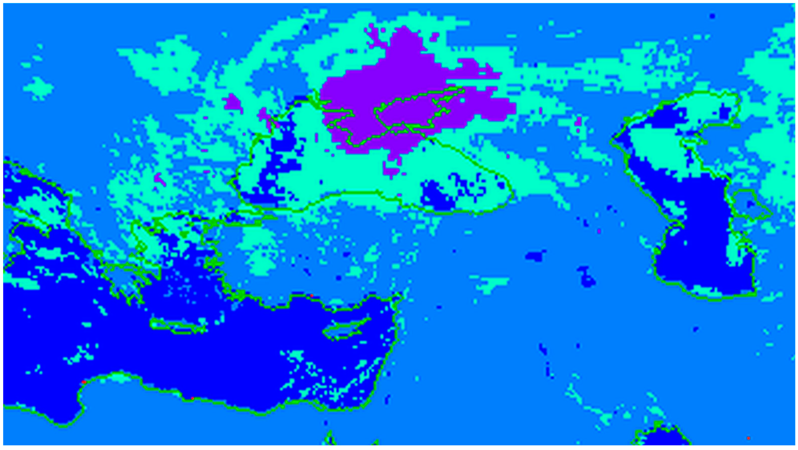

Table 1.
The resulting collection of images.
| Image Type | Image format | Number of images |
|---|---|---|
| Cloud Cover | GRIB/PNG | 536 |
| Precipitation intensity | GRIB/PNG | 578 |
| Synthesized images | PNG | 431 |
Disclaimer/Publisher’s Note: The statements, opinions and data contained in all publications are solely those of the individual author(s) and contributor(s) and not of MDPI and/or the editor(s). MDPI and/or the editor(s) disclaim responsibility for any injury to people or property resulting from any ideas, methods, instructions or products referred to in the content. |
© 2024 by the authors. Licensee MDPI, Basel, Switzerland. This article is an open access article distributed under the terms and conditions of the Creative Commons Attribution (CC BY) license (http://creativecommons.org/licenses/by/4.0/).
Copyright: This open access article is published under a Creative Commons CC BY 4.0 license, which permit the free download, distribution, and reuse, provided that the author and preprint are cited in any reuse.


