Submitted:
01 March 2024
Posted:
04 March 2024
You are already at the latest version
Abstract
This paper explores Ghana's two-decade journey in developing a digital land information system (LIS), exemplified by Ghana Enterprise Land Information System (GELIS) and Enterprise Land Information System (ELIS). Despite advancements by Ghana’s Lands Commission, manual processes persist and coexist with digital ones. Our study uses a qualitative approach to assess the effectiveness of the LIS implemented in Accra. The study found that Accra’s LIS is highly aligned with clear institutional mandates, roles, and responsibilities as well as the availability of laws and policies to support analogue to digital conversion. Furthermore, a robust approach for protecting data, operating system and software underpins the system. Subsequently, the integration of a digital LIS has enhanced service delivery and accountability. Nonetheless, Accra’s LIS is still at the beginning of a comprehensive learning and development curve. To sustain the LIS requires furtherance in the implementation plan, funding, law implementation, ICT strategy, divisional integration, work processes, data quality, and communication strategy. These findings will inform the next steps of improvement for Accra's LIS and guide its nationwide scaling, contributing to discussions on technology acceptance dynamics in predominantly analogue environments.
Keywords:
Land Information System
; Land Administration
; Analogue
; Assessment framework
1. Introduction
Global concerns such as urbanisation, tenure insecurity, land conflict and unequal land access have highly demanded reliable and up-to-date land information. To meet such requests and guarantee ownership rights, scholars have advocated for the development of an information system that can provide records on “who owns what piece of land”, what type of right and value exists”, and “what use is permissible” on time. The performance of these functions lies within the domain of land administration. “Land administration is a process of determining, recording, and disseminating information about land ownership, value, use, and associated resources[1]. According to Enemark [2], the success of land administration depends on an efficient land information system. A land information system is a broad-reaching and complex concept that eludes any simple definition. It encapsulates all the simple unofficial procedures undertaken by individuals or small groups aimed at identifying and organising distinct units of property over a small area as well as the enormous complex set of spatial data acquisition and organisation at the level of a state [3]. A land information system may also refer to all the coordinated and standardised land-related data banks that have the land parcel as the common geographic unit, which work together to provide an integrated methodology for the collection, maintenance, updating and utilisation of land-related information[3]. Thus, a well-designed and implemented LIS enhances land record management and efficient access to information and reduces the bureaucracies in land administration processes [4]. Countries that have successfully implemented LIS for land administration continue to realise the benefits. For instance, experience from developed countries like the Netherlands has demonstrated the usefulness of LIS in making geographic data accessible to all, promoting transparency, and facilitating individual choices about real estate [5].
Unlike developed countries, implementing LIS in developing countries is challenging [6,7]. As a result, in developing countries where LIS is in place, its full potential often remains unexplored[8]. For example, after efficiently implementing LIS in Rwanda, the bureaucratic nature of the registration system discouraged landowners from registering their properties, thereby making the LIS outdated [9]. A similar experience happened in Kenya, where the LIS got outdated because of informal land transactions [10]. Other challenges may result from inadequate land data, poor data quality, and the government’s unwillingness to invest in LIS [11].
The journey to developing a digital LIS in Ghana has been nearly two decades. This resulted in the development of the Ghana Enterprise Land Information System (GELIS) and, subsequently, the Enterprise Land Information System (ELIS). While the former was deployed to integrate the processes of land registration and land use planning across the Lands Commission (LC) and the Land Use and Spatial Planning Authority (LUSPA), the latter was introduced to integrate and automate the processes of registration across the four divisions of the LC in Accra (Ghana’s capital). Despite the digitalisation drive and the numerous developments over almost two decades, manual processes still prevail and remain insurmountable within Ghana’s LC. Much as the factors that account for this paradoxical situation remain unclear, the digital LIS piloted in Accra will be upscaled nationwide if successful. Therefore, the current LIS must be assessed to understand its underlying challenges. Such an assessment will help identify ways to improve the system’s functionality in Accra and pave the way for the contextual implementation of the system in the other regions of Ghana. This study, therefore, seeks to assess the effectiveness of the LIS implemented in Accra. Our study contributes to ongoing discourses on the dynamics of technology acceptance in predominantly analogue environments.
The rest of the paper is structured as follows; section 2 provides a theoretical overview of LIS and explores the various frameworks used in the literature to evaluate LIS performance; a chronological account of digitalisation advancements in Ghana’s land administration is given in Section 3, and an overview of the study’s methodology and subject area is given in Section 4. Ghana’s land administration and information system are presented and discussed in sections 5 and 6.
2. Land Information Systems: A theoretical Perspective
This section provides a detailed overview of the concepts and perspectives of land information systems. It also provides insight into the adoption of information systems from a theoretical perspective. Additionally, Existing assessment frameworks for an information system are reviewed, and the proposed assessment framework for the study is presented in the last part.
2.1. The Concept and Perspective of Land Information System
Many scholars have defined the term LIS differently across various academic disciplines. Following the study of Adiaba and Dale [12,13], LIS consists of land data, human and technical capital, and processes and techniques for data collection, updating, processing, and dissemination. Agreeably, The United Nations Economic Commission for Europe (UNECE) Report in 1996 [14] stated that LIS comprises the land information database and the procedures to collect, update, and distribute land records. There are cases where such an information system was referred to as the general land administration system; thus, the information system could facilitate the implementation of land policies and promote effective land administration. Bishop et al. [15], defined LIS as “a GIS that utilises land parcels as the link to the non-graphic database attributes.” Other studies described this system as an established information system for land management[16].
The typical lesson derived from these definitions is that LIS involves data to produce information, technology to ensure efficient operation, people to carry out its functions, and procedures to ensure adequate land administration. Since what is “badly defined is likely to be badly measured”[17], this study defines LIS as an advanced computerised database system and procedures that allow easy access, retrieval, update, dissemination of land records and land service delivery. That notwithstanding, this study agrees with UNECE[14] that LIS may also be in an analogue form, although studies indicate it is ineffective for land service delivery [18,19].
Computerisation has been a significant driver of change in the land administration domain. According to scholars [14,16,20,21,22,23], applying modern technologies in land information management is optimal for ensuring good land service delivery and cost-effective land administration systems. Agreeably, Ahuja and Singh [24] indicated that introducing a computerised system with internal checks and controls over deeds registration in India helped minimise the potential for error and drastically reduced land conflicts to the barest minimum. In the fourth statement in Cadaster 2014, it was proposed that all countries would have gone digital with “no more pencil and paper” by 2018 [22]. Although this sounds ambitious and optimistic, it appears more of a phantom than an achievable reality, considering that most developing countries struggle to automate their LAS. Beyond introducing modern computers into the land administration system, human and technical resources, policy, legal and institutional frameworks, data quality, and organisational procedures are necessary. Digital transitioning is highly unlikely if these factors are not adequately addressed.
2.2. Land Information System Assessment Models
The first step in assessing any system is defining it; however, there is no universally accepted model or indicators to objectively evaluate the effectiveness of LIS, no matter how it is defined. Steudler [25] emphasised, that the absence of a comprehensive and universally standardised assessment framework could result from the cultural, political and social variations in the land administration systems worldwide. Additionally, the purpose of assessment also influences which indicators to look for, making it impossible to adhere to a specific framework [26]. Due to these variations, The UNGGIM in their Framework for Effective Land Administration (FELA), proposed that the framework serves as a living document subject to constant review to meet evolving needs [27]. Although most assessment frameworks mainly focus on policy and organisational aspects of the land administration system, as identified in[26,28,29,30,31], international bodies, national agencies, and scholars alike have attempted to provide indicators to assess the effectiveness of LIS qualitatively. These indicators are identified and explained in the subsequent subsections.
The frameworks reviewed in this study were selected based on thematic conformity, application scale, and conceptual conformity. While most frameworks focus on other aspects of LAS, these frameworks thematically capture the subject of land information systems. Additionally, they provide a broader application scale that allows the assessment of LIS at the national and sub-national levels. The broader scale of the framework’s application is useful because the scope of this study is at the sub-national level. Lastly, these frameworks capture the relevant concepts in the definition of LIS: data, people, process, and technology. The reviewed assessment frameworks will inform the LIS assessment framework for this study.
2.2.1. Assessment Model Developed by The United Nations Committee of Experts on Global Geospatial Information Management (UN-GGIM)
The United Nations designed the Framework for Effective Land Administration (FELA) for low and medium-income countries. FELA strategically conforms with the Integrated Geospatial Information Framework (IGIF) to serve as a reference guide for member states to develop new geospatial information systems or improve existing ones [27]. The assessment of the effectiveness of geospatial information management is supported at both national and regional levels by optimising seven (7) essential principles, eight (8) goals, and nine (9) strategic pathways. (See Figure 1) for an overview of the framework.
The framework’s strategic pathways are influenced by governance, technology, and people. The nine pathways for guiding, monitoring, and assisting the implementation of an information system are summarised and explained in Table 1 below.
2.2.2. Assessment Model by The World Bank
The World Bank 2012 developed the land governance assessment framework (LGAF) to help countries deal with land governance issues [32]. The framework serves as a tool to guide good land governance practices. It provides the basis for governments to prioritise various land reforms and monitor the progress of such reforms over time. Like FELA, LGAF can be holistically implemented at the national or regional level. Detailed indicators anchor LGAF under five broader themes however, reviewing all five themes is beyond the scope of this study. This paper focuses on the theme of “public provision of information” and how to employ the available indicators to assess the effectiveness of the LIS in Ghana. Table 2 provides an overview of the theme, indicators, and dimensions.
2.2.3. Assessment Indicators by Land Equity International (LEI)
In collaboration with Millennium Challenge Cooperation (MCC), LEI has also identified some critical components to consider in assessing LIS. In 2020, LEI presented five major indicators to guide the assessment of the effectiveness of LIS [33]; the indicators, which are policy and legal framework, institutional framework, technology, finance, and sustainability, employ various dimensions to dissect the appropriateness of land IT systems holistically. The details are summarized and explained below.
Policy and Legal Framework seek to assess if the laws and policies of the country are available and adequate to support the effective implementation of LIS. The general argument is that the implementation of the system requires the adoption of new processes or tools. As such, laws and policies on work processes, data management, standards, data pricing, privacy, and metadata must exist.
Institutional Framework identifies the institutional infrastructure’s viability in providing an enabling environment for LIS implementation. It focuses on three main dimensions institutional processes, capacity, and organisational behaviour.
Technology assesses the technological environment of LIS. It emphasises the hard and soft infrastructure, internet sources, electricity, and how they conveniently facilitate the implementation of LIS.
Finance assesses whether there are adequate financial resources for implementing the LIS.
Sustainability seeks to evaluate whether strategic measures have been put in place to sustain the implementation of LIS in the long run. It focuses on the IT strategy of the organisation, maintenance culture, and risk measures.
2.2.4. Assessment Framework by dr Steudler
Some individual initiatives to assess LAS have been published in literature. Among them are the evaluation framework for assessing the urban cadastral system’s reliability in Ethiopia [30] and a framework for land administration organisations [26]. Although these frameworks fit their adopted purpose, they do not capture the concepts of LIS. Chekole et al. [30] focus on cadastral systems policy, while Showalter focuses on LA organisation. Unlike the above, Steudler[25] presents a holistic framework that captures some important indicators for measuring the quality of the entire LAS by considering five significant evaluation areas: policy, management, operational, external factors, and review process. The areas are further categorised and reviewed from different evaluation aspects. (See Table 3) for an overview of the framework.
2.2.5. The Elements Considered for Assessing the Effectiveness of Land Information Systems
The reviewed models present a realistic perspective to determine the effectiveness of an information system; however, it is equally essential to select dimensions and indicators that align with the purpose of the assessment and the local situation and context [26]. Land administration systems are evolving with unique local conditions. Thus, different indicators and dimensions are required to examine various issues in all aspects of LAS [34]; in our case, LIS in Ghana. In recognition of this, this study considers three key elements commonly identified in all the reviewed models (see Appendix A); (a) governance and people, (b) operational environment, and (c) sustainability measures to assess the LIS in Ghana. These elements are further elaborated on in the subsequent subsections.
- Governance and People
This dimension focuses on policies, legislature, and institutional infrastructure to enhance the adoption of LIS. The absence of policy measures such as guiding documents, procedures on data management, data standards, and data sharing presents challenges in LIS implementation[33]. A country’s legislative framework could threaten its digital land administration drive, especially in cases where laws do not support digital signatories or give precedence to paper records over digital receipts. Therefore, it is relevant to assess the comprehensiveness of the law in ensuring an effective adoption of land information systems.
Additionally, institutional processes, responsiveness to change, and technological competence are relevant considerations for implementing a successful land IT system[33,35]. Clearly defined processes that are less complex and cost-compelling can enhance the effective adoption of LIS [26].
- Operational Environment
The operating environment is one of the key elements influencing LIS adoption[33]. This study defines the operating environment to encompass the system’s technology, data quality, and working environment. Technological tools may not be fit for all purposes. There are instances where technology is established on its abilities instead of purpose. For example, after efficiently implementing a land use and management information system for land use planning in Ghana, planning officers were reluctant to use the technology because it lacked basic drawing features like curves needed in layout and scheme preparations. Although the technology could be used to perform spatial analysis and functions, its inability to draw curved lines rendered it aborted. Every technology varies in goals and operational requirements [36]; therefore, if technology is not fit for the purpose, the effectiveness of the land information system may be compromised.
Additionally, land data is the primary foundation on which LIS is built. Without data, there will be no meaning to LIS. For this reason, there is a need to assess the availability of land data and how it conforms to data quality standards in satisfying the information system’s needs. For LIS to be effective, it is equally important to have a conducive working environment with access to a reliable power supply, good internet connectivity, and basic office logistics and infrastructure[33].
- Sustainability Measures
In addition to an enabling operational environment and fit-for-purpose technological artefacts, clear sustainability strategies are required to sustain the operationalisation of the LIS in the long run [29,32,37,38]. Some studies have categorised such measures into financial, technical, and participatory sustainability[29]. While financial and technical sustainability focuses on maintenance cost, financial commitment, IT capacity, and skills; participatory sustainability focuses on keeping the public informed about the importance of maintaining up-to-date land information [29]. Evidence shows that outdated information systems are incapable of ensuring trust and are ineffective in making decisions [9]. In this recognition, the sustainability element will focus on education and capacity, communication strategy, and most importantly, the availability of ICT strategy, which effectively supports long-term business operations [39].
2.3. The Assessment Framework for LIS in Ghana
This assessment framework hybridises the insights gained from the theories and dimensions commonly identified in FELA, LGAF, LEI (2020), and Steudler (2004). It covers three thematic areas: governance and people, operational environment, and sustainability measures. This framework explores the effectiveness of Ghana’s LIS using qualitative indicators and eight dimensions: organisational framework, policy and legal frameworks, technology, data, working environment, ICT strategy, training and capacity, and communication strategy. Table 4 shows an overview of the framework.
3. Land Tenure and Land Administration in Ghana
The dual tenure system characterises land tenure in Ghana, which the state and traditional authorities’ exercise. The Customary institutions own about 80% of Ghana’s land, while the remaining 20% reside in the state and private individuals [40]. The governance of customary lands resides in the allodial head, which could be heads of stool and skin and family heads. In contrast, under the statutory regime, land governance is administered through a mechanism by the state[40].
Article 258 of the 1992 constitution of Ghana stipulated that the Lands Commission must carry out five distinct functions: land registration, land valuation, surveying and mapping, and public and vested land management. Subsequently, other institutions, such as the Land Use and Spatial Planning Authority, support land administration by regulating land use controls and granting planning comments [41].
To strengthen land administration and enhance coordination between the customary institutions and public land sector agencies, Customary Land Secretariats (CLSs) were established in some traditional areas by the Ministry of Lands and Natural Resources during LAP1 and 2. Among other things, the Land Act, 2022 (Act 1036) mandates the CLSs to keep updated land records of transactions and link landowners to the public land sector. The CLS can now record transactions and prepare lease documents which could be used as proof of transaction. However, under section 14 subsection 4 of Act 1036, the recorded transactions must be submitted to the LC at the end of every three months [42], entrusting the overall land information management to the Lands Commission. It is relevant to mention that the mandate to issue lease documents is only valid in areas where deed registration is in effect. The LC is the sole authority to record and issue certificates in title-declared areas. Thus, in Ghana, deed and title registration are the recognised registration types.
The land administration system in Ghana is predominantly analogue [43]. In Ghana’s first and second land administration projects, plans were made to transition the land administration sector into a digital system by establishing a land information system for title registration under LAP 1 and the Ghana Enterprise land information system in LAP 2 [44]. After these interventions, positive steps have been taken towards implementing LIS. For instance, part of the country’s LAS has been digitalised in seven of Ghana’s sixteen regions, with Greater Accra as the pilot area.
The digitisation drive in Ghana has become very apparent. Section 73 of Act 1036 [42] mandates the LC to establish a land information system equipped with the necessary technological artefact to enhance land interests’ transfer, creation, and registration. The Act further requires that capacity be made available for utilising the information system. Although this is a brilliant initiative, it will require more than a legal framework for a successful implementation.
4. Materials and Methods
The study draws insight from Accra LC on a sub-national scale. Accra is the capital city of Ghana and the most populated city (see Figure 2). The land governance structure in Accra is decentralised among stools, families, states, and individuals; therefore, a person who wants to acquire land must obtain consent from these institutions. It is the only region in Ghana with its entire geographical space declared a title registration area. Currently, the LC is the only body mandated by law to issue land title certificates; this legally centralises the overall land information management in Accra to the LC. Accra is selected as the study area because it has a working LIS that can be assessed across different aspects of land registration. Also, because the region serves as the capital of Ghana, land market transactions are brisk, making the need for up-to-date land information relatively higher.
4.1. Data Sources
This research uses both primary and secondary data. The primary data was collected through interviews with key informants from the Accra Lands Commission (LC) and questionnaires from users (clients) of LC’s services. The key informants were officials from different units of the LC, namely, the Land Registration Division (LRD), Land Valuation Division (LVD), Survey and Mapping Division (SMD), Client Service Access Unit (CSAU), IT department, and Management. These respondents were selected based on (i) their knowledge of the topic, (ii) their level of involvement in activities within the LC (iii) their willingness and availability. Furthermore, to understand how the information system has improved land service delivery, a convenient sampling technique was used to obtain information from clients, i.e. landowners. In total, twenty-three (23) clients were interviewed. Also, eleven (11) key informants were purposefully selected to provide relevant information about the Accra Lands Commission’s LIS.
4.2. Data Analysis
To analyse the primary data across different data sources, we first transcribed the interview recordings and the field notes into text. Then we used conventional content analysis to synthesise the text using the identified themes as a guide. To do this, we go through the transcripts to identify statements, words, and expressions aligning with the themes and indicators identified in section 2.3. This step enabled us to sort the responses to create a picture of the administrative processes of registration in the Accra Lands Commission, highlighting the characteristics of the LIS.
5. Results
This section presents the empirical findings on the state of the land information system in the Accra Lands Commission. First, we describe the actual processes of land registration across the four divisions of the LC. In the second step, we describe the broader framework within which the operations of the LC are mobilized. This cuts a cross-governance (specifically, we look at the policy and legal framework that direct land registration), operational environment (focusing on the deployment of technology, data, and support systems), and sustainability strategies (focusing on the strategies deployed to ensure long-term success in terms of professional and system development).
5.1. Land Administration Processes in Accra LC
Land administration processes in Accra combine digital and manual systems. Four divisions of the LC discharge these processes: surveying and mapping, land valuation, public and vested land management, and land registration. However, other land agencies, such as the Land Use and Spatial Planning Authority and the Customary Land Secretariat, assist in the processes. It is relevant to mention that other units/agencies such as the Client Service Access Unit (CSAU), IT, and Universal Merchant Bank (UMB) play a vital role in land administration in the region. While the UMB assists with payment proceedings between clients and the LC, the IT provides technical support. The CSAU, established in 2016, is a one-stop shop directly connecting clients to the divisions; thus, all division application requests are submitted through the CSAU. The processes undertaken by the divisions are granting concurrence, granting consent, plan approval and barcoding, tax value assessment, verification, processing, and certification. The parts of the processes integrated into the system’s functionalities are outlined in the following sub-sections.
5.1.1. Processes of Public and Vested Land Management (PVLMD)
The activities of PVLMD involve granting consent and concurrence on stool lands. Concurrence is an indication that the LC bears witness to the transaction that has taken place between a party and a stool. On the other hand, the consent process indicates transaction approval for a party who acquired either public or stool land and sought to transfer ownership to another party. Both processes are outlined in Figure 3 and Figure 4.
5.1.2. Processes of Survey and Mapping Division (SMD)
The SMD activities involve plan approvals that encompass barcoding and cadastral plan preparation. During this process, the applicant submits copies of plans; this plan must include a computational file of how coordinates were picked from the site and approval by a private license surveyor. The SMD officer checks the quality of the plan using top corn tools. The plan is scanned into the system if all the quality indicators are met. A barcode containing the parcel’s exact location is generated using the ELIS.
5.1.3. Processes of Land Valuation Division (LVD)
According to an interview with the LVD respondents, this division’s main activity is assessing a property’s tax value before land registration begins. This process is also called assessment of stamp duty. The main actors involved in this activity are the clients, CSAU and LVD. Figure 5 provides a detailed description of all processes involved in stamp duty assessment.
5.1.4. Processes of Land Registration Division (LRD).
The activities carried out by this division are the verification of documents for registration, processing of registration documents, and issuing land title certificates (certification) after registration. According to LRD respondents, the culmination of these activities is the land registration process. This process is outlined in Figure 6.
5.2. Governance and People
Organisational, Legal and Policy Frameworks
The operations of the LC are established under a clear guiding policy and legal instruments. The development of land administration processes, including LIS, is mainly guided by the National Land Policy, the Lands Commission Act, Act 767 (2008) and the Land Act, 2020 (Act 1036). The National Land Policy sets the broader framework for land administration. The Lands Commission Act details the job roles, positions, divisional functions, and general organisational setup. The Land Act details land relations, tenure types, registration processes, and restitution. Additionally, the Land Act establishes an electronic conveyance and mandates the Commission to develop an information system with adequate technological infrastructure to facilitate such conveyancing[42]. The foreground for electronic transactions in Ghana was already laid down in 2008 by the enactment of the Electronic Transaction Act to support digital signatories that may be required to replace manual stamps and signatures in the conveyancing processes.
The conveyancing process at the LC cuts across different land rights, which are specified in section 1 of the Land Act[42]. The Land Act recognises and allows for registering allodial, usufructuary, customary freehold, customary tenancy, and leasehold interests. However, there is a gap between what is specified in law and what is done in practice. This implementation gap leads to the non-registration of some interests. According to officials of LRD, the registration processes typically result in leaseholds neglecting other land rights recognised by law. The officials indicated that registration of usufructuary interests in the current system truncates it to a leasehold interest, and such a transformative effect of registration deters usufructs from registration. This is perhaps the case because the earlier legislation on registration (Land Title Registration Act, Act 152 (1986)) did not provide sufficient guidance on registering other interests. Later, the Land Act provides some steps to register the usufructuary interest. For example, section 39(4) of the Land Act states that “a conveyance of a usufructuary interest shall state the interest conveyed as the usufructuary interest and shall not (a) be expressed as a lease, and (b) have a limited term or duration”. Similarly, the law bars the acquisition of customary freehold interests in stool/skin and family lands but remains silent on that of individual and private lands. To this end, some clarity is still required to implement the Land Act.
To undertake registration, the divisions of the LC deploy different procedures which require standardisation within each division and gateways across divisions for seamless service delivery. For instance, in preparing a cadastral plan, the SMD requires the coordinates of the parcel, the size of the parcel in its imperial units, the bearing, plan number, registration district and locality, scale, surveyors’ signature, and other relevant numbers. These are different from the specifications required by PVLMD in granting concurrence. In an interview with SMD, PVLMD, LVD, and LRD officials, all other standards governing data are specified and regulated by legal instruments such as LI144 for regulating cadastral plan supervision and approval. Additionally, efforts are made to check the compliance of submitted documents to these standards.
As a result of registration, the LC keeps data about individuals, groups, and entities, the usage and storage of which raises privacy concerns. Privacy, protection, access, and restriction to data are clearly outlined in Act 843 [45], and Act 989[46]. Everyone in Ghana has the right to information; however, access to such information should not result in undue loss or gain to a person, a group, a financial institution, or any other body[46]. Given this, the LC duly assesses every request for information/data to determine whether the application safeguards the life or liberty of the party(s) involved.
Like any organisation in a digital transformation, staff and clients require a positive attitude toward adopting new technologies. The staff acknowledge that the digital LA system enables a well-organised and less bureaucratic service delivery and are willing to employ its functionalities in their daily business processes; however, not all the clients are willing to adopt this system. On the other hand, management has implemented strict measures in the system’s usage; thus, one cannot initiate the registration process without deploying the system’s functionalities.
5.3. Operational Environment
Technology
The uptake of technology in the operations of the LC has increased steadily over the years. In the Accra office, which doubles as the head office, many measures have been implemented to provide all relevant hardware and software to fulfil the information system requirement. This is evident in the availability of servers, computers, printers, barcode scanners, and other related accessories. However, the distribution of the hardware is uneven across divisions. While considerable hardware was found in the IT unit, CSAU, LRD, PVLMD, and SMD, little was seen at the LVD. Some officials of LVD indicated that they use their personal computers for the execution of their roles.
Moreover, other responses from management indicated that the LC uses the Enterprise Land Information System software (ELIS), which is internally developed based on their business needs. Thus, ELIS interface varies across the various divisions. The LC also uses Topcorn tools and open-source software such as PostgreSQL and QGIS for database management and geographic data processing. Provision has also been made for server backup; however, the type of backup could not be disclosed due to security reasons. Nonetheless, the LC divisions face uneven data entry and conversion challenges due to the deteriorated state of old cadastral maps.
To interact with the LC using digital systems, the staff and the public need operational manuals to guide their interaction with the system. However, interviews with staff across the units of the LC, namely, CSAU, PVLMD, SMD, LVD, and LRD, reveal that no such operational manuals were available to guide in the convenient use of the system. Provision has however been made for a brochure that outlines the purpose and goals of the information system. They also indicated that IT staff are available to provide the needed guidance in any operational difficulties. Aside from the absence of an operational manual, the divisions/departments are not in unanimous agreement concerning the system’s usability regarding its interface and access to standard features for their daily business activities. In an interview, the SMD, LVD, LRD, and CSAU indicated that the systems interface keeps changing automatically without their prior knowledge. As a result, they sometimes spend an entire day trying to understand and work with the updated interface. If such understanding has not been derived, the entire land administration process must be kept on hold.
Furthermore, the LVD also stated that the system does not provide all the relevant features needed for their scope of work. In assessing the taxable value, LVD must emboss a stamp on the document; this feature is currently non-existent because the system is being developed incrementally. While all departments have indicated that the system is sometimes unreliable due to operational malfunctions, they all attest that the system has suitable navigational components and is focused on the needs of the Commission. The majority of clients who have interacted with the system share similar sentiments with land officers concerning its reliability. 20 out of the 23 respondents indicated that it often breaks down and renders them incapable of executing their transactions at the appropriate time. The CSAU respondents confirmed the client observation and added that it presents a difficult situation for new signups. The way around this is for clients to initiate transactions using previous successful logins of other clients.
Data
Following the registration of parcels, the LC disseminates information to members of the public. In an interview, officials from SMD, PVLMD, LRD, and CSAU indicated that data resources, precisely parcel details, have been consolidated into one database, which officers could query through their secret credentials. However, the LC collaborates with the Land Use and Spatial Planning Authority (LUSPA) for external data such as land use plans and zoning regulations. Although section 117 of the Land Act mandates LUSPA to share data on layout and zoning plans with the Commission, according to officials of LC, this collaboration is constrained. Such data is often not released on time, so clients are sometimes asked to obtain this data from LUSPA. While the PVLMD can convert analogue data into a digital format, the SMD reported that existing map documents are not in good condition for digital transformation, especially with maps dating back to the 1980s. They have become brittle, with some parts remaining missing. As a result, the boundaries of parcels are not visible enough for digitisation.
Working environment
Currently, the divisions of the LC are dispersed and enjoy differential levels of resourcing. The PVLMD, the Consolidated Search Office, and CSAU have an adequate working environment. In contrast, the SMD, LVD, and IT departments do not have sufficient space to accommodate their needs. From observation, one of the LVD and IT offices were overcrowded, with little room for mobility. In response, management is constructing a new building where space, power backup, and internet would be catered for; until then, all activities will be put on hold during power outages. In the case of LRD, LVD, and CSAU, provisions for backup generators have been made; however, they are sometimes unable to use them due to their inability to purchase fuel. The LVD and CSAU share the same geographic area with the IT department; however, in the case of a power crisis, only the IT department is offered backup support.
5.4. Strategies for Sustainability
Capacity
According to an interview with an official of the IT unit, the LC has enough personnel for data management, software, and network management. The IT unit in Accra establishes IT standards and procedures for operational administration and management. Currently, the experts in this department provide IT support to all divisions in Accra and other regional LCs. Thus, the management of the LC indicated that a considerable amount of training had been given to staff, which was confirmed by the staff of the LC. However, given the intermittent changes in the system, staff complain about the system's evolving complexity. In an interview, a staff said;
“We came to work one Friday and were told to go for a two-day training in Koforidua on ELIS because we were to start working with it the following Monday. We returned from the training and could not do anything for that week because most of us did not fully understand it. I recently discovered that requests initiated by clients could be processed from the public tab on the system. Until my discussion with one colleague, I believed clients had not submitted any requests. It appears I never checked at the right place”.
Accordingly, this has resulted in an overreliance on the few with these skills and sometimes causes delays in executing the land administration functions. In response to these challenges, management is making efforts to improve staff capacity through private-sector involvement.
ICT strategy
According to management, questions about the system’s scope, boundaries, budget requirements, and tailored actions cannot be answered regarding the information system. A strategic implementation plan to detail these requirements is non-existent. In an interview, the IT department indicated that the fuzzy nature of the scope and boundaries of the system has slowed down the automation process. According to management, the LC is adopting the agile system development method. However, no specific source of funds is allocated for the system’s development, implementation, and sustenance; only 33% of the income generated by the LC is assigned to the Commission for its day-to-day administration. The remaining 67% goes to a consolidated government account. As a result, the systems development and deliverables are implemented when needed and could be financially supported.
According to the staff of the divisions, support is provided by the IT department in case of difficulties in using the system. This support ranges from fixing broken parts of computers, staff logins and access, and navigating through system updates to other operational malfunctions. To provide this support, a WhatsApp group connects all divisions and departments to IT and serves as a platform where all complaints are made. Thus, there is no physical helpdesk present for users to lodge complaints. While this may seem very convenient considering the dispersed location of the divisions, it puts the clients who cannot share this common platform with the IT in a dilemma. This claim is reinforced by an observation made at the CSAU. A client who had aborted the online process due to a system breakdown had no idea where and when to get redress; the officer from the CSAU to whom she complained kept telling her to wait for the IT. However, how IT would ever know about the complaints is an answer that could not be received.
Regarding system maintenance and protection, the IT department has established controls to protect data, software, and operating systems from unauthorised modification. Aside from using antivirus protection, staff require a VPN and encryption password to access the server containing the digital archives; this way, they can monitor access. Furthermore, there is occasional cyber security training and routine checks to monitor data security compliance. In addition to this is an established network firewall used to observe both outgoing and incoming network routes. Subsequently, the management takes care of all the costs of issuing these security protocols.
Moreover, attempts have been made to physically protect the data within the various divisions and departments. According to an interview with LRD, PVLMD, SMD, CSAU, and IT respondents, access to records within each division and department is strictly out of bounds to non-staff. For the CSAU, PVLMD, and IT departments, staff require a pin to access the working areas; however, these pins only grant access and do not keep track of who accessed it. On the one hand, the LVD and SMD rely on key locks to access such areas. Additional security personnel are available to patrol the LC premises during and after working hours.
Despite the IT staff’s role in the LC’s core business, no strategy is implemented to keep key IT staff for the system’s sustainability. In an interview, a senior official of the LC indicated that the IT staff is just like any other staff of the Commission and does not require any exceptional condition of service. He said;
“They are public servants and understand the terms of services and responsibilities of accepting the job offer. In Ghana, we all follow the single-span salary structure where public workers are placed under one salary structure irrespective of their specialisation. Even if we want to do something about their condition of service, our hands are tied because the government decides how much we spend as Commission”.
When one of the respondents was further probed about what would be done if they returned to work the next day and realised the key IT staff had quit the job because of dissatisfaction, the response was, “people are desperate for a job we will find a replacement”.
Communication Strategy
Regarding communication strategies for the systems development, management indicated that the system’s development is in consultation with users; however, it appears that the reference was being made to the LC staff and not the clients who interact with the Commission. However, after its implementation, they explored various platforms to educate and inform the client about the digital land administration drive. Following the responses from clients, 14 of the 23 indicated no prior knowledge of the information system before interacting with the Commission. These respondents only learned about the system after some officers informed them to use the online portal to submit their applications. 7 out of the 9 respondents with prior knowledge about the system saw it on a poster during a visit to the Commission. The remaining two respondents learned about it from the newspaper. Furthermore, there is no way to provide feedback on the system. If a client has feedback, the CSAU is the first point of contact; however, according to the CSAU, these complaints are frequently not documented for future reference.
6. Assessment of the LIS in Accra
In this section, we discuss the dimensions developed and identified in section 2.3 in the context of Accra LC, along with existing literature.
6.1. Organisational, Policy, and Legal Frameworks
To be effective, LIS must be supported by adequate laws and policies that promote commitment, coordination, and participation. In Ghana, the deployment of digital technologies for LA activities, LA processes, roles, and institutional mandates are foregrounded in Act 1036, Act 772, the National Land Policy, and Act 767 [42,47,48,49] However, executing some processes has created opportunities for duplication. For instance, clients must physically submit hardcopy documents scanned into the system for stamping. This duplicates the client’s work and adds time to the officers’ workload. Officers must evaluate the same documents twice; thus, the scanned and physical documents before stamp embossments to determine if the documents match. Scholars have identified that overlaps and duplications are avoided when mandate clarity is achieved [50]; this, however, may not always be the case, as other factors may be at play. In this study, such factors are centred around the system’s inability to accommodate all LA activities and the need to manually validate document authenticity due to inadequate trust in the digital form.
Act 1036 establishes and recognises allodial, usufructuary, customary freehold, customary tenancy, and leasehold interest as registrable. However, Ghana’s current land register appears to be primarily leasehold, not because landowners with other interest holdings are reluctant to register their land but due to insufficient guidance on the law’s implementation [51]. Currently, the creation of any perpetual interest in land is forbidden by the Land Act; hence, a usufructuary interest which the law defines as perpetual and beyond the mere use and gathering of fruit[52] and the freehold interest obtained through gifts or succession, is truncated into a leasehold during registration. Why would anyone register a land only to accept a loss in meaning and value? The current laws emphasise LIS creation; however, without clear guidelines on how to implement the law, the LIS cannot support the registration of the continuum of rights in Ghana.
In this study, the staff and clients unanimously agree on the efficacy of technology in LA activities; however, efficacy alone is insufficient to facilitate adoption. From the clients, manual LA activities would be their choice if they lack the knowledge, skills, and confidence to optimise a digital system. This implies that other factors may necessitate LIS adoption [53,54,55] and not just its capabilities, as observed in [56]. In contrast, even without enough trust in the digital system, the staff demonstrated a complete willingness to use technology for LA activities; however, such willingness cannot be validated without considering the management’s strict LIS usage rules.
6.2. Technology
Introducing technology into any business process necessitates using system-specific tools compatible with the system’s design and organisational needs. To meet the LIS requirements, Accra LC relies on open-source database management and geographic data processing software, ELIS, network firewalls, Topcon, and backup servers. According to Randhawa [57] open-source software is convenient, inexpensive, and does not require license compliance. However, such software provides no accountability, warranty, or vendor support. Although support is usually accessible via an online community, it sometimes lacks flexibility, and there is no guarantee that the provided solution will work.
Furthermore, some officers must rely on personal computers for daily business operations. Their reasons are that the available monitors, and keyboards, to aid the digital drive are insufficient. Although these computers are operational, they are not physically protected by the LC’s security system and may be vulnerable to theft. In practice, this could pose a serious threat to data security.
Following the study’s findings, the system strategically aligns with the LC’s needs and provides appropriate navigational components; nonetheless, it breaks down frequently and denies access to new clients. Furthermore, no operational manual provides critical information about operating procedures, and developers lack the means to constantly communicate changes and new updates to users, resulting in errors and underutilisation of the time allotted for service delivery. Communication between users and developers should not terminate after a system’s implementation as it can result in the system’s failure[29]. In this study, it is argued that such communication should be two-sided, thus from users to developers and vice versa, but most importantly, extend beyond the internal users.
6.3. Data
Land data is the foundational information for the development of LIS. Without data, LIS cannot function. Such data requires uniform standardisation to be efficient and valuable [58]. While standards vary across the four divisions in Accra, data conformity and interoperability exist. The result is a consolidated database that enables the four divisions to retrieve and share internal data. It confirms that data integration improves a preferable option for data exchange and allows different entities to use it [59,60]. The challenge, however, is that the database does not reflect the entire land register, the complete cadastral coverage of Accra, and land use restrictions on family lands. This gap is attributed to three disparities. First, portions of existing paper documents remain unavailable for digital translation. Second, land registration in Ghana is sporadic, and third, the limited regulations on family land disposition [61]. According to management, there is no current plan to obtain full cadastral coverage to feed the LIS; even if there were, such a plan would be capital-intensive and could not be afforded by the LC. Furthermore, because no system connects LUSPA and the LC, clients are the ones who obtain land use data for their parcels instead of the LC. Adlington [62] argued that LIS implementation frequently fails due to data inadequacies; hence further consideration is required to ensure a successful LIS in Accra.
The study also delves into the LC’s data security measures, as incorporating technology into business processes and daily activities has recently raised numerous privacy concerns. The analogue system may face a greater security risk without a robust legal framework and good business practices. Efforts are made to provide digital security passes, CCTV screens, and security personnel to patrol the LC premises during and after working hours. Additionally, Act 989 of Ghana outlines the measures to protect the privacy and liberty of parties who interact with the LC; however, in Accra, user identification is often compromised due to the system’s unreliability. Though this is a security breach, it could be regarded as a technological challenge; thus, conducting good business practices, in this case, depends on the system’s behaviour. Such occurrences may be unavoidable if the system proves unreliable, regardless of how the laws are formulated. This does not imply that involving technology always results in risk exposure; however, some technological solutions carry more risk exposure than others; therefore, in situations like this, the focus should be on whether the technology is a poor fit or if other factors are at work.
6.4. Working Environment
While a conducive ergonomic environment and reliable power supply and internet connection remain viable for LIS to thrive[33], insight from Accra reveals access to limited space for business activities and an uneven distribution of power and internet resources. It appears that the needs of some divisions have been prioritised over others; thus, staff at LRD, LVD, SMD, and CSAU are insufficiently provided for compared to the IT and PVLMD. As far as the LIS is concerned, all the divisions require equal power and internet availability. For instance, if CSAU activities are halted due to a power or internet outage, the other divisions with access to power and the internet cannot carry out their task because all activities are connected. That is how a system works; it is a set of related activities [63] and neglecting one sub-system could render the others less effective and inefficient.
Nonetheless, automation has improved the LC’s working conditions, including access to monitors, keyboards, mouse controls, and new office furniture. While some employees commented appropriately on the recent development, others who did not yet have access to these new resources provided an unsatisfactory account of their working conditions. According to Bishop et al. [15], organisations may be sceptical about providing infrastructure during the early stages of LIS implementation; however, staff should not feel uncomfortable carrying out their business activities. Measures must be implemented to address situations that may cause discomfort during working hours.
6.5. Capacity and Training
Training and individual efficacy are vital in ensuring effective [56,64]. The current study identified that some form of training was provided to the staff before the system implementation; however, this training was not enough for some staff to optimise the system’s functionalities fully and has allowed opportunities for mistakes. Although experts for database, land administration processes, data, and network security are readily available to support and assist the divisions in Accra and beyond, there is no comprehensive plan to improve the existing capacity to be abreast with the evolving complexities of the system. Additionally, these experts have autonomy in deploying IT standards and procedures for operational management, which raises two questions (a)who provides support and assistance to IT? (b) who ensures the compliance of the IT’s procedures and standards? Unfortunately, these questions cannot be answered due to the lack of a centralised IT governance structure to manage such activities. Hence a fundamental organisational and capacity gap in terms of IT and staff.
6.6. ICT Strategy
Implementation strategy defines the scope and boundaries of the system, as well as the budget, financial plan, and timelines for system deliverables. Studies have identified such strategies as critical components for overall LIS success [65,66]; however, there is no such plan to facilitate system implementation in Accra, and current developments are implemented extemporaneously. There is no dedicated source of funds for the system’s development, implementation, and sustenance; the LC receives only 33% of its annual income for its day-to-day administration. It should be noted that this 33% income is not fixed. For example, 33% of the “X” amount generated today differs from 33% of the “X” amount generated tomorrow because it depends on the total income generated.
An IT help desk is required to ensure that end users are aware of and follow the correct procedures in case of a problem. It is common in any organisation that makes use of IT service support. [67]. Contrary to expectations, a help desk is unavailable to provide technical support to the client in optimising the system. Although technical solutions were available, they were limited to the staff through a shared WhatsApp platform. Thus, external users have no means of communicating unexpected difficulties. According to [68] lacking technical support often results in failure in electronic governance. Accra’s LIS is not a failure considering some of the identified benefits, but the issue of clients not having a place for physical redress is a complete downside of the LIS and could potentially render the system ineffective for service delivery.
The findings on the strategy to retain key ICT staff, are somewhat discouraging. According to management, a replacement was the solution to compensate for the loss of competent IT staff if they abandoned their job due to dissatisfaction with the service condition. Other studies identified that the resignation of key staff on the implementation team was a major reason for Ghana’s unsuccessful workflow re-engineering during the first land administration reform [69]. Furthermore, most digital LA fail because of losing critical staff during and after implementation [33]. In Accra, the absence of an ICT strategy is mainly influenced by two factors: the placement of public servants under one salary structure and government control over fund allocation. Thus, there is no independence in allocating financial resources for project and strategy implementation.
6.7. Communication Strategy
A previous study has noted the relevance of communication before and after implementing LIS[29]. One would assume that the development of a system requires consultation and communication with all users; thus, external and internal, as identified in[39]. In Accra, such consultation was primarily limited to internal users. However, management admits that the public was adequately informed about the LIS through various media platforms after its implementation. 14 of the 23 clients indicated that they did not know about the LIS before interacting with the LC; additionally, there is no consideration for feedback input. Subsequently, the impact of this awareness campaign was beyond the scope of this study and considering the small sample size; caution must be applied as these findings might not necessarily imply that the awareness campaign strategy was ineffective. While studies may have identified an awareness campaign as one of the commitments to ensuring LIS sustainability[70], it may be ineffective if the system is not designed to meet the needs of all users.
6.8. Summary of LIS Assessment in Accra
Following the results and discussion of the study, the assessment of LIS in Accra is given on three rating scales in Table 10: High Alignment (HA), Medium Alignment (MA), and Low Alignment (LA). “High alignment” ratings are indicators that are present and implemented to enhance LIS usage. Medium alignment” are indicators present and operational but do not sufficiently improve the LIS effectiveness. “Low alignment” are indicators that are ineffectively implemented or not present at all to support LIS.
7. Conclusions
The study aims to assess the land information system for land administration in Ghana by drawing on evidence from Accra. This was achieved by reviewing frameworks for LIS assessment in literature. The reviewed frameworks were selected based on their ability to be applied on a broader scale and thematically capture the concepts and components of LIS definitions. Based on this review, an assessment framework consisting of three themes, eight dimensions and twenty-three indicators was developed to assess the effectiveness of the LIS in the study area.
From the study, we see that the processes of registration in the Accra LC is in high alignment with three indicators, namely; (1) clear institutional mandates, roles, and responsibilities, (2) availability of laws and policies to support analogue to digital conversion and (3) availability of strategy to protect data, software and operating system. Furthermore, from the assessment result, Accra is in medium and low alignment with thirteen and seven indicators, respectively (see subsection 6.8).
The study further shows that integrating the LA services into the system’s functionalities has enhanced data integration and interoperability, business operations, accountability and service delivery. However, this study could not decipher the extent to which external factors like using unofficial services from land officers and agents facilitated such improvements. The unofficial involvement of LC officials with clients has been documented in the study of Abubakari et al. (2019), whereby officials act as facilitators in exchange for personal benefits.
Despite the efforts of Ghana’s LC to embrace a workable digital LIS over the years, there are still significant limitations of the LIS in Accra. The LIS in Accra requires improvement in eight major areas: implementation plan, funding, law implementation, ICT strategy, divisional integration, work processes, data quality and communication strategy. Given that the piloting in Accra still has significant challenges and the marked differences between Accra and the other regions in registration systems, further challenges are anticipated during scaling up nationwide.
The indicators with low alignment largely concern the sustainability of the LIS, which has profound implications for growth and upscaling at the nationwide level [72]. We see that the public’s ability to interact with the LIS effectively is hampered since there is no support interface for the public. Even more disturbing is the fact that no system implementation plan suggests a sporadic implementation. Also, the lack of a retention strategy for core IT staff signals adverse ongoing concerns of the LIS. Essentially, the internal mechanisms to support the effective running of the LIS and the support system to enable the public to interact with the system continuously are hanging in the balance. This dynamic explicates the two dilemmas characterised by Pritchett [73] namely, (a) systemic isomorphic mimicry, wherein a persistent lack of function is covered up by adopting the external forms of functional undertakings from elsewhere (in this case, the setting up of the LIS); and (b) premature load bearing, which routinely places highly unrealistic expectations on fledging systems and thus allows failure to exist while creating the illusion of implementing developmental policies. Concerning Pritchett’s second dilemma, it is amazing how over the last decade, the Lands Commission has been engaged in legal and institutional reforms yet unable to address the issues of information acquisition and management within the Lands Commission. While not downplaying the efforts of the Lands Commission, we contend that the issues of sustainability that are currently lacking need to be addressed if nationwide scalability is intended.
Our findings thus serve as pointers that signal areas for further improvement of the LIS in Ghana. Beyond the Accra Lands Commission, our findings provide valuable insights into the consideration for scalability at a nationwide scale.
Author Contributions
Conceptualization, R.O.A., Z.A., D.T and C.L.; methodology, R.O.A., Z.A., D.T and C.L.; formal analysis, R.O.A and Z.A.; investigation, R.O.A and B.Q; writing—original draft, R.O.A and Z.A.; writing—review and editing, R.O.A., Z.A., D.T and B.Q.; supervision, D.T and C.L. All authors have read and agreed to the published version of the manuscript.
Funding
This research received no external funding.
Data Availability Statement
The datasets presented in this article are not readily available because it relates to system that is being developed and considered sensitive at the moment. Requests to access the datasets should be directed to ro.owusuansah@gmail.com.
Acknowledgments
We would like to thank the Accra Lands Commission for their cooperation during the data collection process.
Conflicts of Interest
The authors declare no conflicts of interest.
Appendix A
An Overview of the Reviewed Frameworks Under Four Thematic Areas

| THEME | FELA | LGAF | LEI | STAUDLER | ||
|---|---|---|---|---|---|---|
| Governance and people |
|
|
|
|||
| Sustainability |
|
|
|
|
||
| Operational environment |
|
|
|
|
||
|
||||||
| Others |
|
|
||||
References
- “Land Administration in the UNECE Region: Development Trends and Main Principles | UNECE.” Accessed: Sep. 30, 2021. [Online]. Available: https://unece.org/housing-and-land-management/publications/land-administration-unece-region-development-trends-and.
- S. Enemark, “Land Management and Development,” Brussels, 2005.
- J. R. Quintero, “Land Information System,” N. J. Smelser and P. B. B. T.-I. E. of the S. & B. S. Baltes, Eds., Oxford: Pergamon, 2004, pp. 1–6. [CrossRef]
- A. Meijer, “Understanding modern transparency,” International Review of Administrative Sciences, vol. 75, no. 2, pp. 255–269, 2009. [CrossRef]
- Kadaster International, “About Kadaster international - Kadaster.com.” Accessed: Sep. 18, 2021. [Online]. Available: https://www.kadaster.com/about-us.
- Z. A. Berisso and W. T. de Vries, “Exploring characteristics of GIS Adoption Decisions and Type of Induced Changes in Developing Countries: The Case of Ethiopia,” The Electronic Journal of Information Systems in Developing Countries, vol. 40, no. 1, pp. 1–16, Jan. 2010. [CrossRef]
- Z. X. Correia, A. B. Moore, and D. P. Goodwin, “Accessibility of land data and information integration in recently-independent countries: Timor-Leste case study,” Papers in Regional Science, vol. 100, no. 1, pp. 203–225, Feb. 2021. [CrossRef]
- Karikari, J. Stillwell, and S. Carver, “Land administration and GIS: The case of Ghana,” Progress in Development Studies, vol. 3, no. 3, pp. 223–242, 2003. [CrossRef]
- M. Biraro, “Land Information Updating: Assessment and Options for Rwanda,” University of Twente, 2014.
- D. N. Siriba and S. Dalyot, “Adoption of volunteered geographic information into the formal land administration system in Kenya,” Land use policy, vol. 63, pp. 279–287, Apr. 2017. [CrossRef]
- S. Yaw Adiaba, “A Framework for Land Information Management in Ghana,” University of Wolverhampton, 2014. [Online]. Available: https://wlv.openrepository.com/bitstream/handle/2436/332138/THESIS 0920118 doc.pdf?sequence=1&isAllowed=y.
- P. F. Dale and J. D. McLaughlin, Land Administration. UK: Oxford University Press, 1999. [Online]. Available: https://linkinghub.elsevier.com/retrieve/pii/S0895796705000530.
- G. Larsson, Land registration and cadastral systems : Tools for Land Information and Management. New York, USA: Longman Scientific & Technical, 1991. Accessed: Jan. 18, 2022. [Online]. Available: https://archive.org/details/landregistration0000lars/page/n9/mode/2up.
- UNECE, “Land Administration Guidelines,” New York and Geneva, 1996. [Online]. Available: http://www.unece.org/fileadmin/DAM/hlm/documents/Publications/land.administration.guidelines.e.pdf.
- D. Bishop et al., “Spatial data infrastructures for cities in developing countries,” Cities, vol. 17, no. 2, pp. 85–96, Apr. 2000. [CrossRef]
- S. Hull and J. Whittal, “Good e-Governance and Cadastral Innovation: In Pursuit of a Definition of e-Cadastral Systems,” South African Journal of Geomatics, vol. 2, no. 4, pp. 342-357–357, 2013.
- Organisation for Economic Cooperation and Development, Handbook on Constructing Composite Indicators: Methodology and User Guide. OECD, 2008.
- P. D. Ameyaw and W. T. de Vries, “Transparency of Land Administration and the Role of Blockchain Technology, a Four-Dimensional Framework Analysis from the Ghanaian Land Perspective,” Land (Basel), vol. 9, no. 491, pp. 1–25, Dec. 2020. [CrossRef]
- P. Ameyaw and W. de Vries, “Toward Smart Land Management: Land Acquisition and the Associated Challenges in Ghana. A Look into a Blockchain Digital Land Registry for Prospects,” Land (Basel), vol. 10, no. 3, p. 239, Mar. 2021. [CrossRef]
- B. Dhakal, “Can we get better information by any alternative to conventional statistical approaches for analysing land allocation decision problems? A case study on lowland rice varieties,” Land use policy, vol. 54, pp. 522–533, Jul. 2016. [CrossRef]
- K. Hale, “How Information Matters: Networks and Public Policy Innovation,” Georgetown University Press. Accessed: May 24, 2021. [Online]. Available: https://books.google.nl/books?hl=en&lr=&id=5z9KBUVk3yUC&oi=fnd&pg=PP2&ots=5n8ptL7ekW&sig=hw1VveKb1EW5mNs57zRO2NoxcL0&redir_esc=y#v=onepage&q&f=false.
- J. Kaufmann and D. Steudler, “Cadastre 2014: A Vision for a Future Cadastral System,” 1998.
- G. Romano, P. Dal Sasso, G. Trisorio Liuzzi, and F. Gentile, “Multi-criteria decision analysis for land suitability mapping in a rural area of Southern Italy,” Land use policy, vol. 48, pp. 131–143, Nov. 2015. [CrossRef]
- M. Ahuja and A. P. Singh, “Computerization of Land Records in West Bengal,” Man and Development, vol. 28, pp. 59–76, 2006.
- D. Steudler, “A Framework for the Evaluation of Land Administration Systems,” The University of Melbourne, 2004.
- A. Showaiter, “Assessment of a Land Administration System: a Case Study of the Survey and Land Registration Bureau in Bahrain,” University of Twente, 2018. [Online]. Available: https://webapps.itc.utwente.nl/librarywww/papers_2018/msc/la/showaiter.pdf.
- UNGGIM, “Framework for Effective Land Administration: A reference for developing, reforming, renewing, strengthening, modernizing, and monitoring land administration,” 2020.
- Z. Ali, A. Tuladhar, and J. Zevenbergen, “Developing a framework for improving the quality of a deteriorated land administration system based on an exploratory case study in Pakistan,” Nordic journal of surveying and real estate research, vol. 7, no. 1, pp. 30–57, 2010.
- T. Burns, “Land Administration Reform: Indicators of Success and Future,” Agriculture and Rural Development, pp. 1–244, 2007.
- S. D. Chekole, W. T. de Vries, and G. B. Shibeshi, “An Evaluation Framework for Urban Cadastral System Policy in Ethiopia,” Land (Basel), vol. 9, no. 60, pp. 1–12, 2020.
- S. Enemark and P. van der Molen, “Capacity Assessment in Land Administration,” Copenhagen, Denmark, 2008.
- K. Deininger, H. Selod, and A. Burns, “The Land Governance Assessment Framework: Identifying and Monitoring Good Practice in the Land Sector,” The World Bank, no. April 2010, p. 168, 2012.
- Land Equity International, “Land Administration Information and Transaction Systems Final State of Practice Paper,” Wollongong, 2020.
- H. Zhang and C. Tang, “A performance assessment model for cadastral survey system evaluation,” Cadastre: Geo-Information Innovations in Land Administration, pp. 33–45, Jan. 2017. [CrossRef]
- World Bank, “Digital Government Readiness Assessment Questionnaire,” Washington, DC, 2019.
- M. Lengoiboni, C. Richter, and J. Zevenbergen, “Cross-cutting challenges to innovation in land tenure documentation,” Land use policy, vol. 85, pp. 21–32, Jun. 2019. [CrossRef]
- M. Biraro, J. Zevenbergen, and B. K. Alemie, “Good Practices in Updating Land Information Systems that Used Unconventional Approaches in Systematic Land Registration,” Land (Basel), vol. 10, no. 4, p. 437, Apr. 2021. [CrossRef]
- FAO, “Voluntary Guidelines on the Governance of Tenure: At a Glance,” Rome, 2012. Accessed: Dec. 14, 2021. [Online]. Available: www.fao.org/nr/tenure.
- D. Todorovski, “Developing a ICT Strategy for the State Authority for Geodetic Works in the Republic of Macedonia Developing a ICT Strategy for the State Authority for Geodetic Works in the Republic of Macedonia,” The University of Twente, 2006.
- A. Arko-Adjei, “Adapting Land Administration to the Institutional Framework of Customary Tenure. The case of peri-urban Ghana,” University of Twente, Enschede, 2011.
- E. D. Kuusaana and N. Gerber, “Institutional synergies in customary land markets - Selected case studies of large-scale land acquisitions (LSLAs) in Ghana,” Land (Basel), vol. 4, no. 3, pp. 842–868, 2015. [CrossRef]
- Parliament of Ghana, Land Act. Ghana, 2020, pp. 1–214. [Online]. Available: https://ocr-aa.s3.amazonaws.com/media/public/documents/LAND_ACT2020._ACT_1036.pdf.
- O. D. Boateng, “Country Profile Of The Land Administration Domain For Ghana: With The Inclusion Title, Deed, Customary And Informal Systems Of Land Registration,” University of Twente, 2021.
- G. Deane, R. Owen, and B. Quaye, “The Ghana Enterprise Land Information System (GELIS) as a Component of National Geospatial Policy,” Washington, DC: The World Bank, 2017, pp. 1–21.
- D. Protection, Data Protection Act, 2012. Ghana: Parliament of Ghana, 2012, pp. 1–43. Accessed: May 20, 2023. [Online]. Available: https://nita.gov.gh/wp-content/uploads/2017/12/Data-Protection-Act-2012-Act-843.pdf.
- Parliament of Ghana, Right to Information Act. 2019, pp. 1–44.
- Government of Ghana, Electronic Transaction Act. 2008, pp. 1–74.
- Ministry of Lands and Forestry, “National Land Policy,” Accra, Jun. 1999.
- Parliament of Ghana, Lands Commission Act. 2008, pp. 1–18. Accessed: May 31, 2022. [Online]. Available: https://landwise-production.s3.amazonaws.com/2022/03/Ghana_Lands-Commission-Bill_2008.pdf.
- N. Ihebuzor, D. O. Lawrence, and A. W. Lawrence, “Policy Coherence and Mandate Overlaps as Sources of Major Challenges in Public Sector Management in Nigeria,” International Business Research, vol. 14, no. 1, p. 68, Dec. 2020. [CrossRef]
- Z. Abubakari, C. Z. Abubakari, C. Richter, and J. Zevenbergen, “Exploring the ‘implementation gap’ in land registration: How it happens that Ghana’s official registry contains mainly leaseholds,” Land use policy, vol. 78, 2018. [CrossRef]
- G. Woodman, “The Scheme of Subordinate Tenures of Land in Ghana,” Am J Comp Law, vol. 15, no. 3, pp. 457–477, Jul. 1966. [CrossRef]
- I. Masser, H. Campbell, and M. Craglia, GIS Diffusion:The Adoption and Use of Geographical Information Systems in Local Government in Europe, 1st Editio. London: CRC Press, 1996. [CrossRef]
- C. A. Badurek, “Identifying barriers to GIS-based land management in Guatemala,” Dev Pract, vol. 19, no. 2, pp. 248–258, 2009. [CrossRef]
- I. B. Karikari, “Ghana ’ s Land Administration Project ( LAP ) and Land Information Systems ( LIS ) Implementation : The Issues,” International of Federation of Surveyors, vol. Article of, no. February, pp. 1–19, 2006.
- Z. Zeng and C. B. Cleon, “Factors affecting the adoption of a land information system: An empirical analysis in Liberia,” Land use policy, vol. 73, pp. 353–362, Apr. 2018. [CrossRef]
- S. Randhawa, “Open Source Software and Libraries,” Chandigarh, 2008.
- M. Cockburn, R. Henderson, and S. Stern, “The Impact of Artificial Intelligence on Innovation: An Exploratory Analysis,” in The Economics of Artificial Intelligence : An Agenda, vol. Publisher, A. Agrawal, J. Gans, and A. Goldfarb, Eds., University of Chicago Press, 2019, pp. 115–146.
- M. S. Gal and D. L. Rubinfeld, “Data standardization,” New York University Law Review, vol. 94, no. 4, pp. 737–770, Oct. 2019. [CrossRef]
- OECD, Data-Driven Innovation : Big Data for Growth and Well-Being. Paris: OECD Publishing, 2015. Accessed: Jun. 02, 2022. [Online]. Available: https://books.google.com/books/about/Data_Driven_Innovation_Big_Data_for_Grow.html?id=Cn-qCgAAQBAJ.
- W. M. Appau, “Land Registration Process Modelling for Complex Land Tenure System in Ghana,” University of Twente, Enschede, 2018.
- G. Adlington, “eBook: Real Estate Registration and Cadastre. Practical Lessons and Experiences,” in FIG Working Week, 2021, pp. 1–16. Accessed: May 30, 2022. [Online]. Available: https://gadlandreg.com.
- The Association of Business Executives, “Systems Analysis,” London, 2015. Accessed: Jun. 03, 2022. [Online]. Available: www.abeuk.com.
- B. J. Weiner, “A theory of organizational readiness for change,” Implementation Science, vol. 4, no. 1, pp. 1–9, Oct. 2009. [CrossRef]
- T. Clohessy, H. Treiblmaier, T. Acton, and N. Rogers, “Antecedents of blockchain adoption: An integrative framework,” Strategic Change, vol. 29, no. 5, pp. 501–515, 2020. [CrossRef]
- Y. M. Wang, Y. S. Wang, and Y. F. Yang, “Understanding the determinants of RFID adoption in the manufacturing industry,” Technol Forecast Soc Change, vol. 77, no. 5, pp. 803–815, 2010. [CrossRef]
- M. Harcenko, P. M. Harcenko, P. Dorogovs, and A. Romanovs, “IT Service Desk Implementation Solutions,” Scientific Journal of Riga Technical University. Computer Sciences, vol. 42, no. 1, pp. 68–73, Jan. 2011. [CrossRef]
- M. Alshehri and S. Drew, “A Comprehensive Analysis of E-government services adoption in Saudi Arabia: Obstacles and Challenges,” International Journal of Advanced Computer Science and Applications, vol. 3, no. 2, 2012. [CrossRef]
- S. B. Biitir, A. W. Miller, and C. I. Musah, “Land Administration Reforms: Institutional Design for Land Registration System in Ghana,” Journal of Land and Rural Studies, vol. 9, no. 1, pp. 7–34, Jan. 2021. [CrossRef]
- R. M. Bennett, M. Pickering, and J. Sargent, “Transformations, transitions, or tall tales? A global review of the uptake and impact of NoSQL, blockchain, and big data analytics on the land administration sector,” Land use policy, vol. 83, no. June 2018, pp. 435–448, 2019. [CrossRef]
- Z. Abubakari, C. Richter, and J. Zevenbergen, “Making space legible across three normative frames: The ( non-) registration of inherited land in Ghana,” Geoforum, 2019. [CrossRef]
- M. M. Mustaquim and T. Nyström, “Designing information systems for sustainability - The role of universal design and open innovation,” in Advancing the impact of Design Science: Moving from theory to practice:9th International Conference, DESRIT 2014, Miami, FL, USA, May 22-24, 2014. Proceedings, M. C. Tremblay, D. VanderMeer, M. Rothenberg, A. Gupta, and V. Yoon, Eds., Miami: Springer International Publishing, 2014, pp. 1–16. 22 May. [CrossRef]
- L. Pritchett, M. Woolcock, and M. Andrews, “Looking Like a State: Techniques of Persistent Failure in State Capability for Implementation,” Journal of Development Studies, vol. 49, no. 1, pp. 1–18, Jan. 2013. [CrossRef]
Figure 1.
Framework for Effective Land Administration.
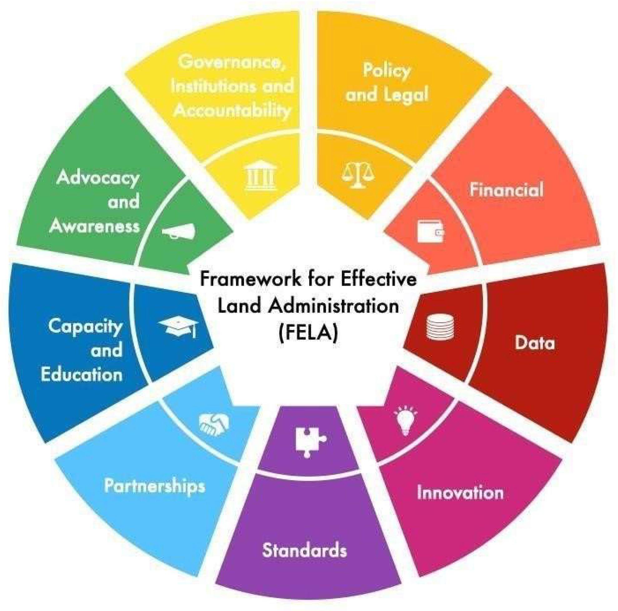
Figure 2.
Map of Study Area.
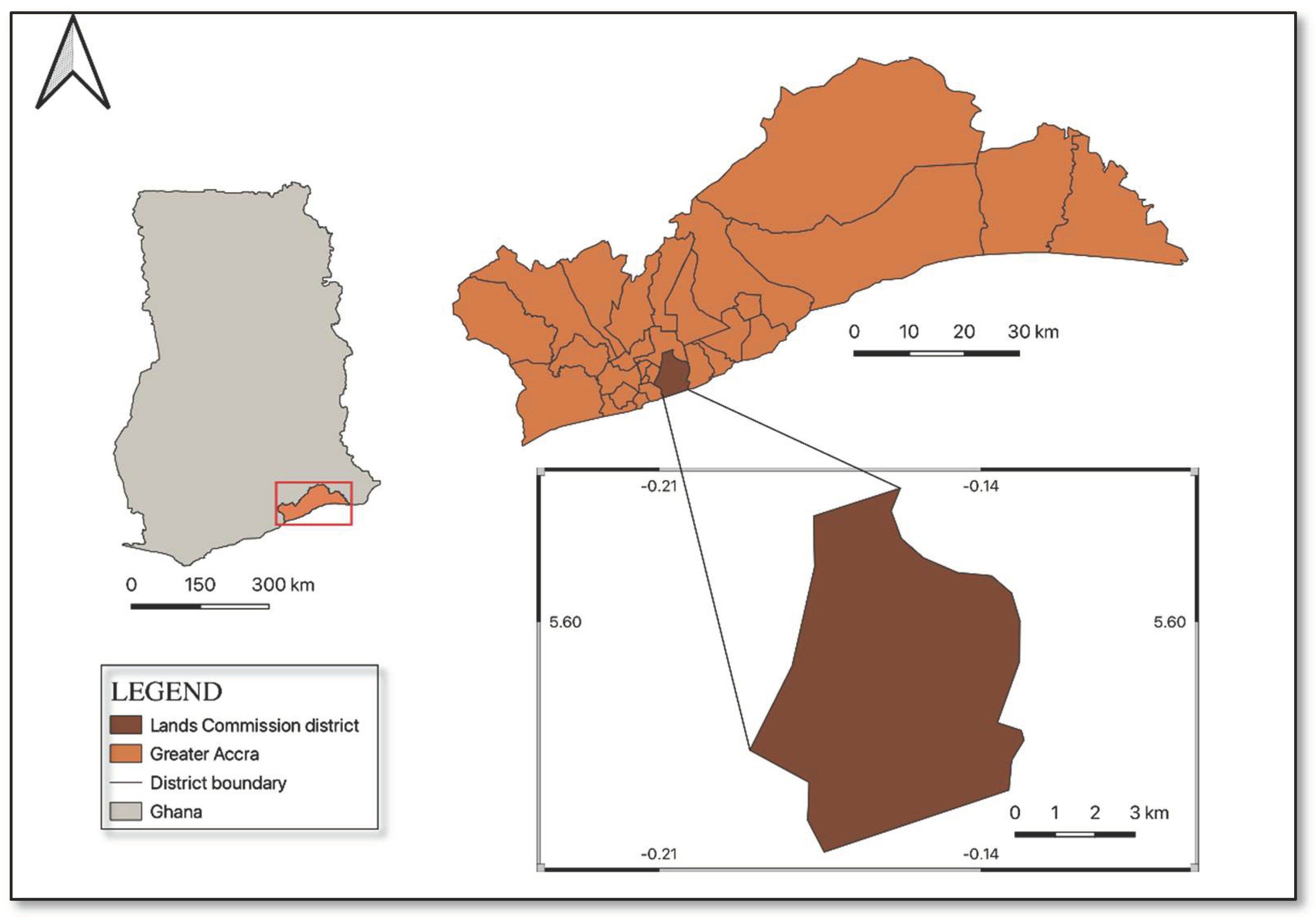
Figure 3.
Activities in Granting Consent.
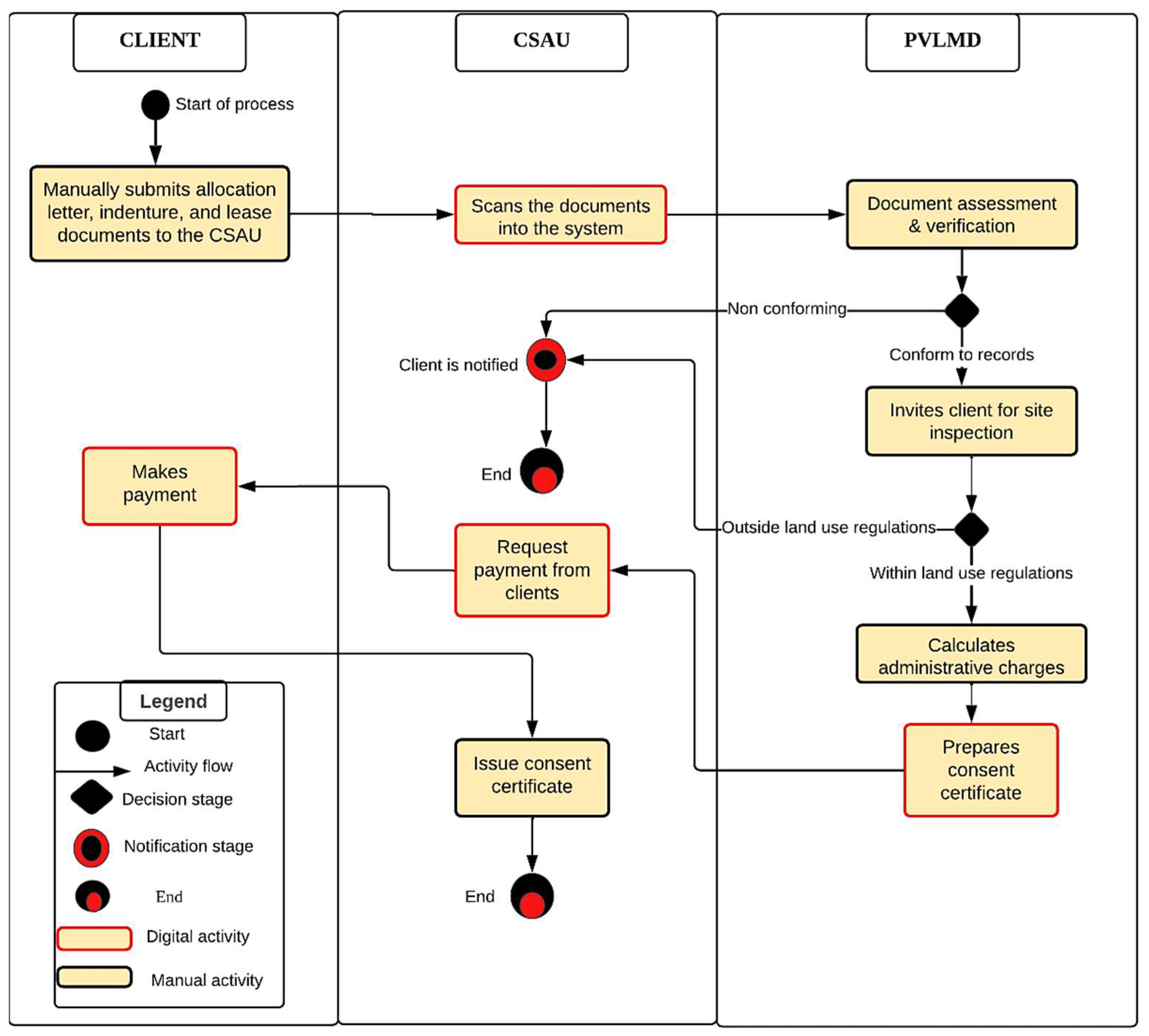
Figure 4.
Activities in Granting Concurrence.
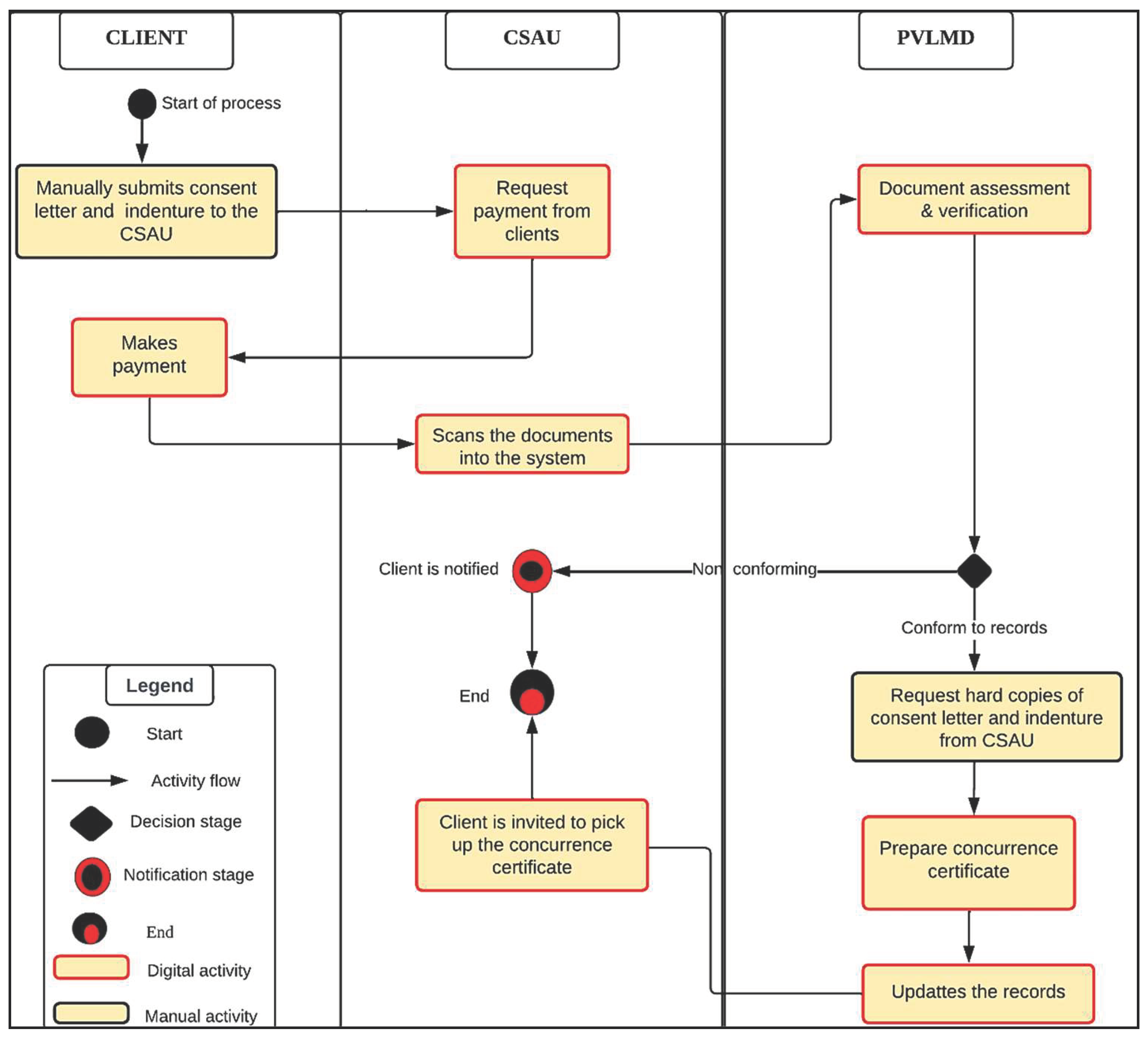
Figure 5.
Stamp Duty Process Workflow in Accra.
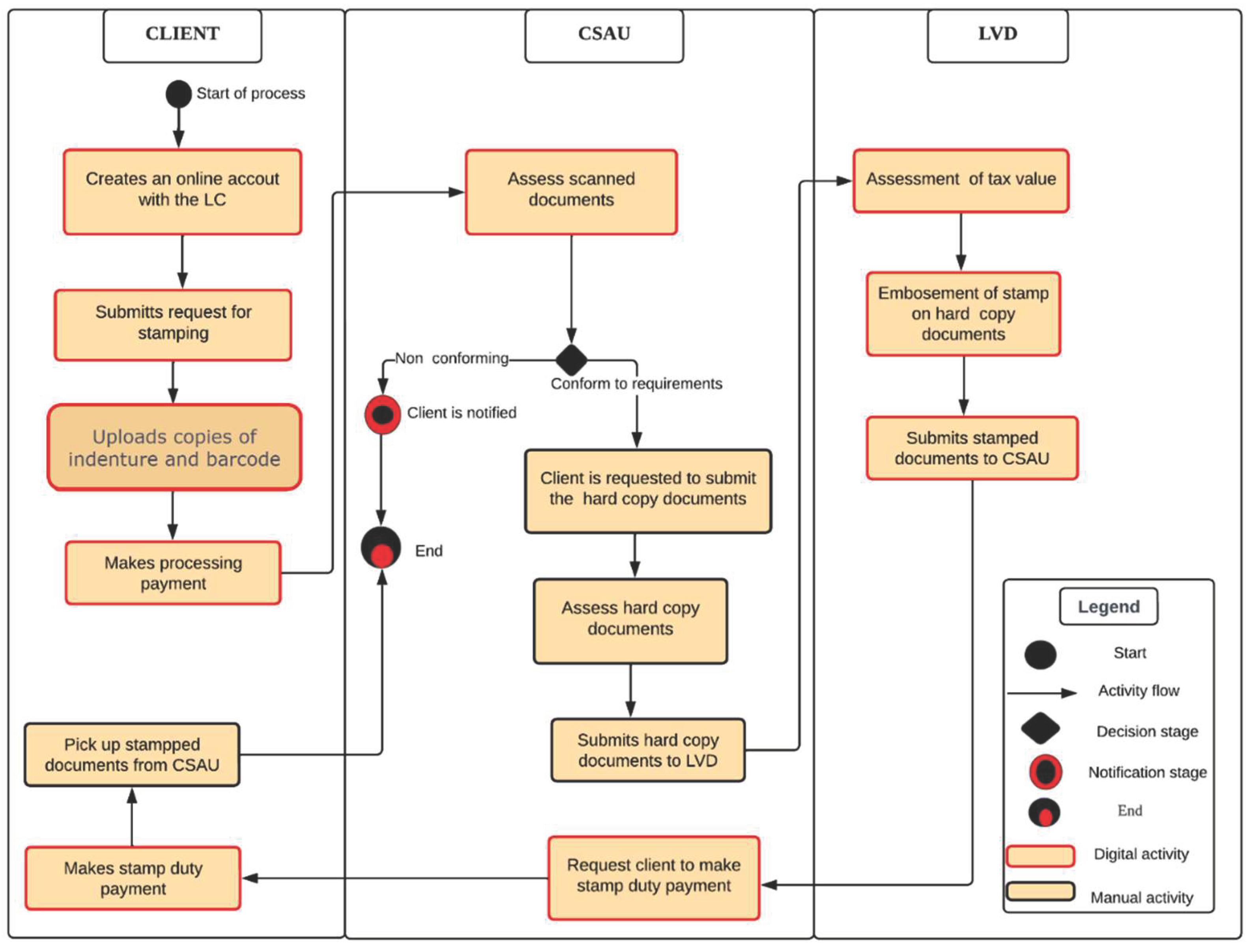
Figure 6.
Registration Process Workflow in Accra.
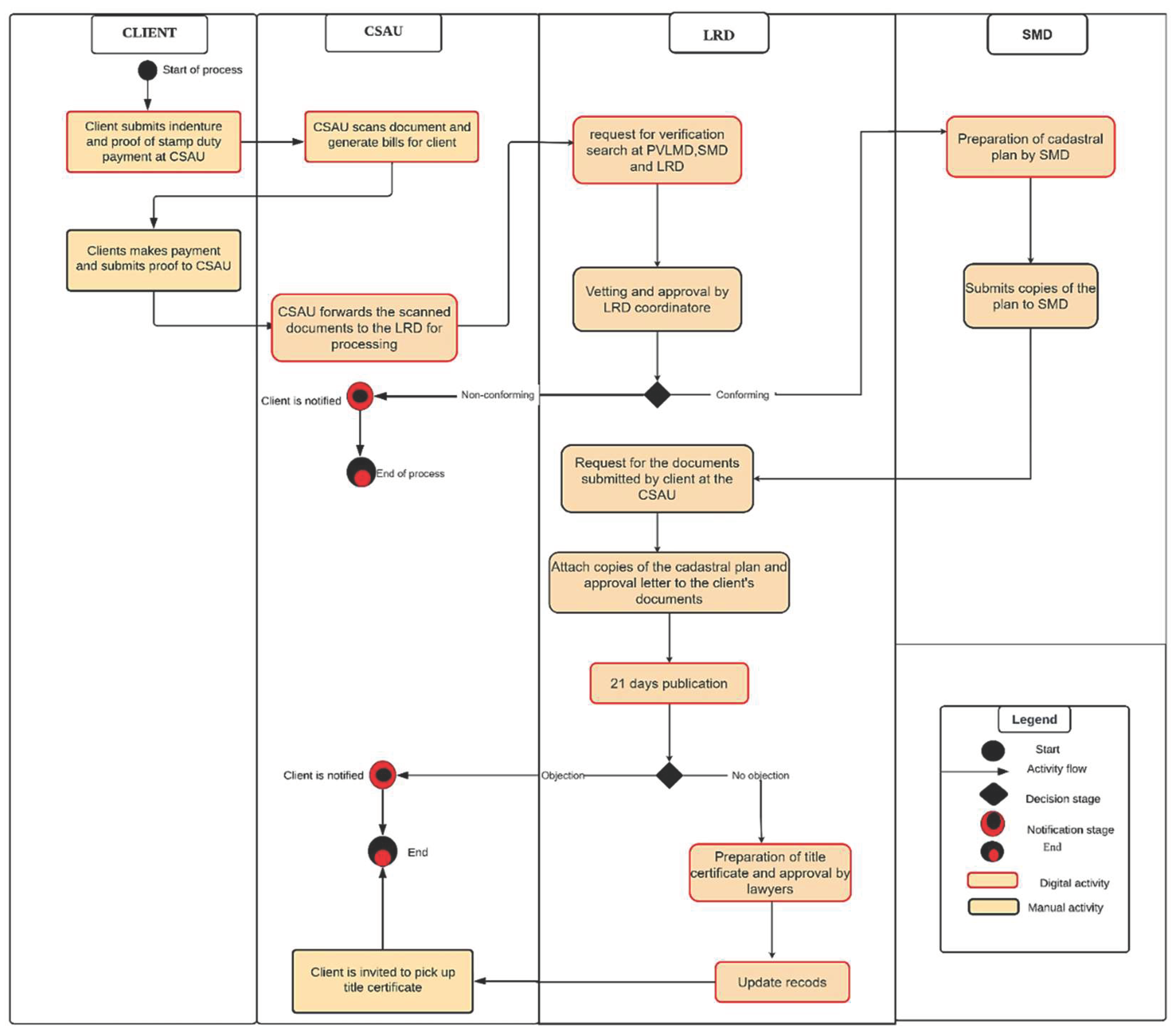
Table 1.
Summary of Nine Pathways.
| PATHWAYS | DESCRIPTION |
| Governance and Institutions | Measures the governance model, institutional arrangement, structures, and commitment to achieve a successful geospatial information management system. |
| Legal and policy | Focuses on the legal and policy environment and its influence on land information management |
| Financial | Focuses on implementation cost and the financial commitment required to provide a long-term sustainable information system |
| Data | Measures the means of acquiring, organising, integrating, and archiving land information and the overall management of data sharing and reuse |
| Innovation | Focuses on the choice of technology (hardware and software) and how it strategically aligns with the institutional processes |
| Standard | This measures how different information systems communicate and exchange data in a manner that is not subjected to more than one interpretation |
| Partnership | It measures the value of land information through trusted partnerships that acknowledge community needs, organisational needs, and national interests |
| Capacity and Education | Measures the skills, instincts, techniques, and resources needed by an organisation and communities to optimise LIS for decision-making |
| Communication and Engagement | It measures stakeholders’ engagement and input in implementing an information system |
Table 2.
The Land Governance Assessment Framework-Public Provision of Information.
| THEME: PUBLIC PROVISION OF INFORMATION | ||
|---|---|---|
| Land Governance Indicators | Dimensions | |
| LG 16 | Completeness of the land registry | Mapping of registry records |
| Relevant private encumbrances | ||
| Relevant public restrictions | ||
| Searchability of the registry | ||
| Accessibility of registry records | ||
| Timely response to requests | ||
| LG 17 | Reliability of Registry Records | Registry focus on client satisfaction |
| Cadastral/registry info up to date | ||
| LG 18 | Cost-Effectiveness and Sustainability | Cost to register transfer |
| Financial sustainability of the registry | ||
| Capital investment | ||
| LG 9 | Transparency | Fee schedule public |
| Informal payments discouraged | ||
Table 3.
The Assessment Framework by Dr Steudler.
| Evaluation areas | Evaluation Aspects |
|---|---|
| Policy level | Land policy aspects and objectives |
| Historical, political, and social aspects | |
| Land tenure and legal aspects | |
| Financial and economic aspects | |
| Environmental sustainability aspects | |
| Management level | Strategic aspects |
| Institutional and organisational aspects | |
| Human resources and personnel aspects | |
| Cadastral and land administration principles | |
| Operational level | Definition of users, products, and services |
| Aspects affecting the users | |
| Aspects affecting products and services | |
| External factors | Capacity building, education |
| Research and development | |
| Technological supply | |
| Professional aspects | |
| Review process | Review Process |
| User satisfaction | |
| visions and reform |
Table 4.
The Assessment Framework for LIS in Ghana.
| Theme | Dimension | Indicators |
|---|---|---|
| Governance and People | Organisational Framework | Institutional mandates, roles, and responsibilities are clear without overlapping functionalities |
| The land administration process is clearly defined and integrated into the functionalities of the information system | ||
| Positive attitude toward Information, Communication, and Technology (ICT) Adoption | ||
| Policy and Legal Frameworks | Availability of laws and policies to support analogue to digital conversion | |
| The system is ready to process all the different types of land rights, right holders, and restrictions | ||
| Data standards, data privacy, data security, and data sharing options are properly regulated | ||
| Operational environment | Technology | Availability of strategy to implement the system’s specifications (thus strategies to ensure that the computer hardware, software, backups, and storage space needed for effective LIS are available) |
| The availability of user-friendly manuals | ||
| The availability of a user-friendly system | ||
| Data | Data is available with the relevant attributes to be fed into the system | |
| Availability of plan to get a complete cadastral coverage | ||
| Working Environment | Availability of a suitable ergonomic environment | |
| Reliable power supply and internet connection | ||
| Sustainability measures | ICT strategy | Availability of a help desk to provide technical support and assistance |
| Availability of strategy to retain key IT staff (thus if IT staff is well motivated) | ||
| Availability of strategy to protect data, software, and operating system | ||
| Availability of system implementation plan | ||
| Training and Capacity | Availability of IT experts for database, land administration processes, and data and network security. | |
| The staff has adequate training in using the information system | ||
| Availability of a plan to get the capacity available | ||
| Communication Strategy | There is a public awareness campaign with content focusing on all the stakeholders of the information system | |
| Availability of an option for a feedback mechanism |
Table 10.
Assessment Result of LIS in Accra.
| INDICATORS | RATINGS | ||
|---|---|---|---|
| HA | MA | LA | |
| Institutional mandates, roles, and responsibilities are clear without duplication of activities | √ | ||
| The land administration process is clearly defined and integrated into the LIS functionalities | √ | ||
| Positive attitude toward Information, Communication and Technology (ICT) Adoption | √ | ||
| Availability of laws and policies to support analogue to digital conversion | √ | ||
| The LIS is ready to process all the different types of land rights, right holders, and restrictions | √ | ||
| Availability of strategy to implement the system’s specifications (thus strategies to ensure that the computer hardware, software, backups, and storage space needed for effective LIS are available) | √ | ||
| The availability of user-friendly manuals | √ | ||
| The availability of a user-friendly system | √ | ||
| Data is available with the relevant attributes to be fed into the LIS | √ | ||
| Availability of plan to get a complete cadastral coverage | √ | ||
| Availability of a suitable ergonomic environment | √ | ||
| Reliable power supply and internet connection | √ | ||
| Availability of a help desk to provide technical support and assistance | √ | ||
| Availability of strategy to retain key IT staff (thus, if IT staff is well motivated) | √ | ||
| Availability of strategy to protect data, software and operating system | √ | ||
| Proper regulation of data standards, privacy, security and data sharing | √ | ||
| Availability of system implementation plan | √ | ||
| Availability of IT experts for database, land administration processes, data and network security | √ | ||
| The staff has adequate training in using the LIS | √ | ||
| Availability of a plan to get the capacity available | √ | ||
| There is a public awareness campaign with content focusing on all the stakeholders of the LIS | √ | ||
| Availability of an option for a feedback mechanism | √ | ||
Disclaimer/Publisher’s Note: The statements, opinions and data contained in all publications are solely those of the individual author(s) and contributor(s) and not of MDPI and/or the editor(s). MDPI and/or the editor(s) disclaim responsibility for any injury to people or property resulting from any ideas, methods, instructions or products referred to in the content. |
© 2024 by the authors. Licensee MDPI, Basel, Switzerland. This article is an open access article distributed under the terms and conditions of the Creative Commons Attribution (CC BY) license (http://creativecommons.org/licenses/by/4.0/).
Copyright: This open access article is published under a Creative Commons CC BY 4.0 license, which permit the free download, distribution, and reuse, provided that the author and preprint are cited in any reuse.


