Submitted:
02 March 2024
Posted:
04 March 2024
You are already at the latest version
Abstract
The availability of current land cover and land use (LCLU) information for monitoring the status of land resources has considerable value in ensuring sustainable land use planning. Similarly, the need to provide updated information on the extent of LCLU change in West Africa has become apparent, given the increasing demand for land resources driven by the rapid population growth in the sub-region. SERVIR West Africa, a regional consortium jointly supported by USAID and NASA to foster the use of geospatial and earth observation data and science for decision-making on critical environmental and food security challenges, in collaboration with the Food and Agriculture Organization of the United Nations (FAO), is building technical capacity in the sub-region to develop and implement harmonized regional land cover classification system for LULC change monitoring in West Africa, based on the Land Cover Meta Language (LCML-ISO 19144-2). This article focuses on the process, potential opportunities, outputs of this collaboration, exemplary use cases, and recommendations for the next steps.
Keywords:
land cover and land use
; land cover classification
; data harmonization
; semantic interoperability
; ISO-19144-2
; West Africa
; geospatial.
1. Introduction
The availability of current and accurate land cover and land use (LCLU) information is essential for monitoring land-based indicators of the Sustainable Development Goals (SDGs). Thus, the United Nations recognizes land cover information as a fundamental geospatial data theme layer [1]. The African Union (AU) Agenda 2063 envisions, among others, productive agriculture and healthy ecosystems with a well-preserved environment and a continent resilient to climate change [2]. Similarly, the Economic Community of West African States (ECOWAS) Regional Environmental Action Plan (EAP), adopted in 2008 and revised in 2020, seeks explicitly to “reverse trends of natural resource degradation and depletion to guarantee to the people of the sub-region, a healthy environment that consequently improves on the living conditions of the population” [3,4] The EAP highlights the presence of “ineffective collaboration, linkages and coordination among institutions of environmental management” and calls for the “minimization of duplications, to ensure synergy and coherence amongst the various actors.” These noble ideas and objectives require adequate information on land cover assessment, the dynamics of its use, and impacts on land, agriculture, forests, and water resources. However, land cover maps produced by professionals in West Africa are based on various land cover classification systems, datasets, tools, and methodologies. Additionally, there is a lack of documentation, and in cases where attempts are made to characterize land features, class descriptions are unclear and limit the useability of land cover maps. Without consistent, up-to-date land cover and land use information for the West Africa sub-region, global and continental data sets are used for regional and, in some instances, national land change assessment and impact studies. Therefore, there is an urgent need for a regional semantic interoperability framework that incorporates different map scales and production objectives and unambiguously defines land cover classes using internationally accepted standards. Subsequently, capacity enhancement of professionals to utilize tools and approaches developed by the Food and Agriculture Organization of the United Nations (FAO) for land cover change monitoring is critical. It is, however, instructive to note that making land cover legends interoperable does not mean replacing the previous classification systems. Instead, land cover legends compatible with the International Organization for Standardization (ISO) international nomenclature would facilitate map comparability, accuracy assessment, and area estimates of land cover classes.
2. Regional and National Land Cover mapping Initiatives
Given the unprecedented land cover change in recent decades, West Africa has attracted the attention of project initiatives seeking to strengthen the capacities of regional and national institutions to produce current LCLU-related datasets for monitoring land change and vegetation-based indicators. Within the scope of the ESA-GlobCover 2005 project, the 300m global land cover map for 2005 was updated in 2010 by the European Space Agency (ESA) in partnership with the Joint Research Centre (JRC), European Environment Agency (EEA), Food and Agriculture Organization (FAO), United Nations Environment Programme (UNEP), Global Observation for Forest Cover and Land Dynamics (GOFC-GOLD) and International Geosphere-Biosphere Programme (IGBP) to produce a global land cover map from this time series of (Medium Resolution Imaging Spectrometer Instrument Fine Resolution (MERIS FR) 2009 mosaics. A typical global legend based on the FAO land cover classification system (LCCS) was used to generate a land cover map at the scale of all of Africa [5]. In 2016, the Agrometeorology, Hydrology, and Meteorology Regional Center (AGRHYMET) collaborated with the U.S. Geological Survey (USGS) to jointly publish an atlas of West Africa’s land cover [6]. The atlas utilized National Aeronautics and Space Administration (NASA) and United States Geological Survey (USGS Landsat imagery to classify the region’s patterns of land cover for the years 1975, 2000, and 2013, and updated by AGRHYMET to the year 2018 (Figure 1). In parallel, the Sahara and Sahel Observatory (OSS) also developed land cover maps for North and West Africa based on data from the European Sentinel-2 satellites [7]. Likewise, the West African Science Service Centre on Climate Change and Adapted Land Use (WASCAL) has supported the development of LULC maps at both regional [8], national [9], and sub-national [10] scales. Similarly, in its second Research and Action Plan (WRAP 2.0), WASCAL is supporting high-resolution LULC mapping through two projects, namely “greenhouse gas (GHG) emissions and mitigation options under climate and land use change in West Africa concerted regional modeling and assessment (CONCERT WEST AFRICA)” and “land surface processes as a determinant of climate change in Africa – scenarios, high-resolution modeling and development of a stakeholder data portal (LANDSURF)” [11]. The SERVIR Applied Science Teams have recently supported activities related to future land use scenario development and integration of time series earth observation data for land use planning [12,13]. The diversity of land cover mapping projects in the absence of a harmonized classification system necessitated the establishment of the West Africa Land Cover Task Force (WALC-TF) to moderate land cover mapping and monitoring initiatives in West Africa and ensure the harmonization of disparate legends in the sub-region.
3. The West Africa Land Cover Task Force
In June 2018, under the auspices of ECOWAS, SERVIR West Africa hosted a regional conference on land cover classification and methodologies in Accra, Ghana, to engage regional and international experts on the harmonization of land cover classification systems and methods used in the sub-region to map land cover. Following the conference, an inter-institutional group, the WALC-TF, was established to address the conference recommendations: harmonizing land cover products across the region and developing standards for describing product accuracy compatibility with international standards. The Task Force was also mandated to coordinate and facilitate access to suitable capacity development programs for regional researchers, practitioners, and policymakers. The Task Force consists of members from the SERVIR-West Africa consortium, namely the Agrometeorology, Hydrology, Meteorology Regional Center (AGRHYMET), the African Regional Institute for Geospatial Information Science and Technology (AFRIGIST), the Centre de Suivi Écologique, (CSE) in Senegal, the Centre for Remote Sensing and Geographic Information Services (CERSGIS) in Ghana, African Regional Institute for Geospatial Information Science and Technology (AFRIGIST) and the Higher Institute of Space Studies and Telecommunications (ISESTEL) in Burkina Faso. Other international institutions outside of the SERVIR West Africa consortium include the West African Science Service Center on Climate Change and Adapted Land Use (WASCAL), the Sahel-Saharan Observatory (OSS), the Global Observation of Forest Cover and Land Dynamics-West Africa Regional Network (GOFC/GOLD-WARN), the Joint Research Center of the European Commission (JRC), and the Food and Agriculture Organization of the United Nations (FAO) [14]. The Task Force comprises over 60 experts from different organizations to share knowledge and experiences about land cover and land use in West Africa.
4. Opportunities
4.1. Land Cover Reference System Development
Efforts by the WALC-TF have been immensely complemented by the FAO’s technical assistance through collaborative capacity-building initiatives in partnership with ECOWAS, the Permanent Inter-State Committee for Drought Control in the Sahel (CILSS), OSS, and SERVIR West Africa, to firstly develop the West African land cover reference system (WALCRS) [15]. The reference system holds scientific and developmental significance for the sub-region. It is a necessary step towards creating an ISO-based international reference system for land cover legends for a sub-region where land cover mapping objectives vary widely, ranging from agricultural monitoring to ecosystem service assessment, land use planning, land degradation monitoring, GHG inventories, climate change mitigation and adaptation assessment, and disaster response. Each country has specific objectives, leading to inconsistencies in regional land cover maps. The reference system simplifies understanding the relationship among land features using object-oriented meta classes, thereby eliminating ambiguities in defining land features and legends, ensuring interoperability among the other existing legends. Therefore, the WALCRS will greatly facilitate regional, national, and local land monitoring, providing an objective science-based framework required to monitor land resources, as the West Africa Regional Conference on Land Cover Land Use in 2018 recommends.
4.2. Land Cover Data Inventory
Before the WALCRS development, a survey was conducted by the FAO Geospatial Unit to assess historical, existing, and future land cover mapping initiatives in the sub-region. Experts from academia and the public sector from national and regional organizations responded to the invitation to participate in the survey. However, respondents from Nigeria, Liberia, Burkina Faso, Togo, Cote d’Ivoire, Mali, Niger, Tchad, Benin, Senegal, and Guinee answered the questionnaire (Figure 2). The results revealed that while most respondents have contributed to land use and land cover activities in the sub-region, less than 50% have used the FAO land cover classification system (LCCS) (Figure 3). Regarding the availability of land cover datasets and legends by county in the sub-region, while the West Africa land use land cover time series dataset and legend are available and accessible, national land cover maps and legends are not. The national legends are, therefore, not ISO-19144-2 compliant (Figure 4).
4.3. The West African Land Cover Reference System
As part of the data harmonization process, regional consultations were organized to strengthen the collaboration among national, regional, and international stakeholders and prepare for operationalizing the regional reference system in the sub-region. The system development also involved a literature review and understanding of various land cover systems used in the region to identify areas where harmonization is required for interoperability. Data inventory survey and stakeholder engagement were critical in setting a framework for the West African Land Cover Reference System (WALCRS). Additionally, the role of subject matter experts from the FAO was instrumental in creating the relevant building blocks for the reference system. The WALCRS is based on international ISO standards, namely, ISO-19144-2 and LCML for land cover. The land cover meta language (LCML) was used to represent land cover features as predefined standardized primitives or basic objects capable of aggregation to real-world features and subsequently described with relevant attributes. This will facilitate semantic interoperability of different land cover legends in the sub-region and enable the generation of consistent dynamic land cover databases (Figure 5 and Figure 6).
4.2. Capacity Building
While land cover mapping professionals have been introduced to the land cover legend registry (LCLR) and LCML, webinars have also been organized for GIS and remote sensing specialists on a variety of free and open-source tools such as SEPAL (System for Earth Observation Data Access, Processing and Analysis for Land Monitoring) [17] and Collect Earth Online (CEO) [18], to produce current LCLU data for effective natural resource monitoring. SEPAL is an open-source, cloud-based platform that provides users access to extensive archives of free earth observation data. It has a user-friendly interface for the processing and analysis of the datasets. Conversely, CEO is an online platform for performing sample-based image interpretation through visualization and classification of multiple high-resolution images. It also facilitates the collection of reference observations in satellite image data at sample locations without downloading satellite images. Synergies between the NASA SERVIR Applied Science Teams and the FAO have bolstered capacity-building programs on sampling and inference techniques, sampling and response design, sampling-based area estimation, and multi-criteria spatial modeling for land use planning. These customized training designed for land and natural resource managers in the sub-region are expected to create the necessary critical mass of human resources for land cover change monitoring and ecosystem assessment. The significant result of this development is the robust collaboration forged by regional and national institutions in the sub-region, FAO, and the NASA-funded Applied Science Teams.
4. Future Perspective
The logical next step is the operationalization of the WALCRS in the sub-region to provide harmonized comparable land cover datasets to prepare reliable baseline land cover information for countries in West Africa. This endeavor will entail dissemination, operationalization in pilot countries, and scaling up the system across the sub-region. The critical feature of this process is the translation and documentation of existing land cover legends through engagement with national stakeholders. The Land Characterization System Software (LCHS) developed as a sequel to the LCCS 3/LCML, and the Land Cover Legend Registry (LCLR) will be used for the pilot phase. The plan of activities developed by the FAO in consultation with the West Africa Land Cover Task Force is intended to enhance the technical capacities of national partners in the sub-region for practical land cover data usage in monitoring land change in West Africa.

Table 1.
Activity plan for the operationalization of WALCRS.
|
|
|
|
|
|
5. Conclusion
Strengthening the technical capacities of national partners is crucial for practical land cover data usage in monitoring land change in West Africa. The LCML has emerged as the global standard for harmonizing and interoperable classification systems and legends. Semantic ontologies have become effective means for achieving common classification systems and standards. Therefore, making legends of land cover maps produced for West Africa ISO-compliant is necessary to compare regional and national LCLU map products of the same standard. The FAO LCML tool will be applied to achieve land cover harmonization across the sub-region. This does not mean one land cover classification system will be adopted. Instead, the various land cover classification systems will be made interoperable. The harmonization process will require continued engagement and dialogue among regional experts and institutions for the harmonized approach to be fully adopted in West Africa. It is instructive to note that many land cover maps will continue to be produced according to user requirements and methodologies. However, standardized map products will ensure adaptability to multiple uses. This will serve as a means to reduce redundancies in efforts and costs and enhance regional cooperation. The collaboration with FAO in this regard is a significant step forward in West Africa.
Land cover products developed for applications in West Africa frequently do not measure or communicate accuracy. A critical requirement is a set of standards for accuracy assessment and map area estimates for land use and land cover features. Additionally, the WALC-TF, together with FAO and the SERVIR-NASA Applied Science Teams, are in the process of developing guidelines and methods to make map producers and users appreciate the importance of map accuracy and uncertainty to ensure that land cover and land use maps are fit for purpose. ECOWAS, through its Commission of Agriculture, Environment and Water Resources, is well-placed to encourage a broader understanding and utilization of land cover and land use data by national member states in their sustainable development efforts and for meeting international reporting requirements. Furthermore, ECOWAS provides a forum for creating awareness and policy initiatives in which land cover and land use products are applied. The objectives highlighted by the AU Agenda 2063 and the ECOWAS Regional Environmental Action Plan, adopted in 2008 and revised in 2020, may be addressed through the harmonization of regional land cover and land use classification systems and, more directly, of land-based analyses for decision-making at the national and sub-national levels. The SERVIR West Africa Land Cover Task Force has demonstrated amply the synergies and collaborative approaches required to operationalize the objectives envisaged in the ECOWAS Regional Environmental Action Plan.
Availability Statement
The West African Land Cover Reference System can be downloaded from https://www.fao.org/geospatial/resources/detail/en/c/1600226/ (accessed 22 February 2024).
Author Contributions
Writing—original draft, Fo.M., P.B., Fa.M., H.M., Data curation, Fa.M., M.H., A.D.G; Writing—review and editing, Fo.M., Fa.M., M.H., A.D.G., J.A., E.C., M.M., B.M., A.M.D., P.S., G.E. and N.F.M. This publication is made possible by the support of FAO and the American people through the United States Agency for International Development (USAID). The contents are the authors’ sole responsibility and do not necessarily reflect the views of FAO, USAID, or the United States Government.
Informed Consent Statement
Not applicable
Acknowledgments
The authors would like to thank FAO, USAID, and NASA for the funding and technical support and the reviewers for the comments that helped improve the manuscript.
Conflicts of Interest
The authors declare no conflict of interest.
References
- UN-GGIM. The 14 Global Fundamental Geospatial Data Themes. https://ggim.un.org/meetings/GGIM-committee/9th-Session/documents/Fundamental_Data_Publication.pdf. Accessed on 23.07.2023.
- African Union Commission (2022). Second Continental Report on the implementation of the Agenda 2063. ISBN: 978-1-77634-908-1.
- ECOWAS (2008). ECOWAS Environmental Policy; Abuja, Nigeria. Forty-eight pp. Available online: http://www.ecowrex.org/system/files/repository/2008_ecowas_environmental_policy_-_ecowas.pdf.
- IUCN (2016).West Africa Environmental Policy Briefing Note; Ouagadougou, Burkina Faso. Twelve pp. Available online: https://www.iucn.org/sites/dev/files/content/documents/policy_brief_wa_environmental_policy.pdf.
- Arino, O. (2010). GlobCover 2009.
- CILSS (2016). The Landscapes of West Africa: A Window on a Changing World. U.S. Geological Survey EROS, 47914 252nd St, Garretson, SD 57030, United States.
- Sahara and Sahel Observatory (OSS). (2019). Building Resilience Through Innovation, Communication and Knowledge Services (BRICKS). The Sahel and West Africa Atlas of Land Cover Maps. http://193.95.75.173/sites/default/files/publications/OSS-BRICKS-Atlas_En.
- Gessner, U.; Machwitz, M.; Esch, T.; Tillack, A.; Naeimi, V.; Kuenzer, C.; Dech, S. Multi-sensor mapping of West African land cover using MODIS, ASAR and TanDEM-X/TerraSAR-X data. Remote. Sens. Environ. 2015, 164, 282–297. [Google Scholar] [CrossRef]
- Knauer, K.; Gessner, U.; Fensholt, R.; Forkuor, G.; Kuenzer, C. Monitoring Agricultural Expansion in Burkina Faso over 14 Years with 30 m Resolution Time Series: The Role of Population Growth and Implications for the Environment. Remote. Sens. 2017, 9, 132. [Google Scholar] [CrossRef]
- Forkuor, G.; Conrad, C.; Thiel, M.; Zoungrana, B.J.-B.; Tondoh, J.E. Multiscale Remote Sensing to Map the Spatial Distribution and Extent of Cropland in the Sudanian Savanna of West Africa. Remote. Sens. 2017, 9, 839. [Google Scholar] [CrossRef]
- König, L., Teucher, M., Ziegler, K., Abel, D., Weber, T., Paeth, H., & Conrad, C. (2023). Development of a Web-Based Decision Support System to Provide Relevant Climate Indicators for Climate Change Adaptation (No. EGU23-12019). Copernicus Meetings.
- Peeling, J.A.; Singh, A.; Judge, J. A Structural Equation Modeling Approach to Disentangling Regional-Scale Landscape Dynamics in Ghana. Front. Environ. Sci. 2022, 9. [Google Scholar] [CrossRef]
- Peeling, J. A., Singh, A., Judge, J., Chen, C. Integrating Time Series Remote Sensing Information in Suitability Analysis for Land Use Planning. In IGARSS 2022-2022 IEEE International Geoscience and Remote Sensing Symposium, 2022, July. (pp. 6372-6375). IEEE.
- Bartel, P., Bako, M., Mbow, C., et al. 2018. Roadmap towards harmonizing land use/land cover mapping in West Africa: Conference report of the West African Land Classification and Methodologies Conference. SERVIR West Africa, Niamey, Niger. Available online: https://www.researchgate.net/publication/331276537_SERVIR_LULC_Conference_Report.
- Di Gregorio, A., Mushtaq, F., Tchana, E., Aw, M., D’Annunzio, R., Muchoney, D., Mamane, B., Mahamane, M., Assoumana, B.T., Mimouni, M., Aubee, E., Enaruvbe, G.O., Mensah, F., Bartel, P. and Henry, M. 2022. West African Land Cover Reference System. Rome, FAO, AGRHYMET, ECOWAS, and OSS. https://doi.org/10.4060/cc0730en. [CrossRef]
- Mushtaq, F.; Henry, M.; O’brien, C.D.; Di Gregorio, A.; Jalal, R.; Latham, J.; Muchoney, D.; Hill, C.T.; Mosca, N.; Tefera, M.G.; et al. An International Library for Land Cover Legends: The Land Cover Legend Registry. Land 2022, 11, 1083. [Google Scholar] [CrossRef]
- FORIS, O. SEPAL (System for Earth Observation Data Access, Processing and Analysis for Land Monitoring). URL: http://www. Fao. org/3/CA1085EN/ca1085en. pdf (дата oбращения 11.06. 2019).
- Saah, D.; Johnson, G.; Ashmall, B.; Tondapu, G.; Tenneson, K.; Patterson, M.; Poortinga, A.; Markert, K.; Quyen, N.H.; Aung, K.S.; et al. Collect Earth: An online tool for systematic reference data collection in land cover and use applications. Environ. Model. Softw. 2019, 118, 166–171. [Google Scholar] [CrossRef]
- O’Brien, D. C., Di Gregorio, A., Mushtaq, F., Henry, M., Tchana, E., Mosca, N.,... & Muchoney, D. (2021). Register Implementation for Land Cover Legends. Food Agriculture Organization of the United Nations (FAO): Rome, Italy.
Figure 1.
The West Africa Land Use Land Cover Time Series dataset maps. These baseline maps at a 2-kilometer resolution provide a complete and highly accurate record of the LULC for three time periods [6].
Figure 1.
The West Africa Land Use Land Cover Time Series dataset maps. These baseline maps at a 2-kilometer resolution provide a complete and highly accurate record of the LULC for three time periods [6].
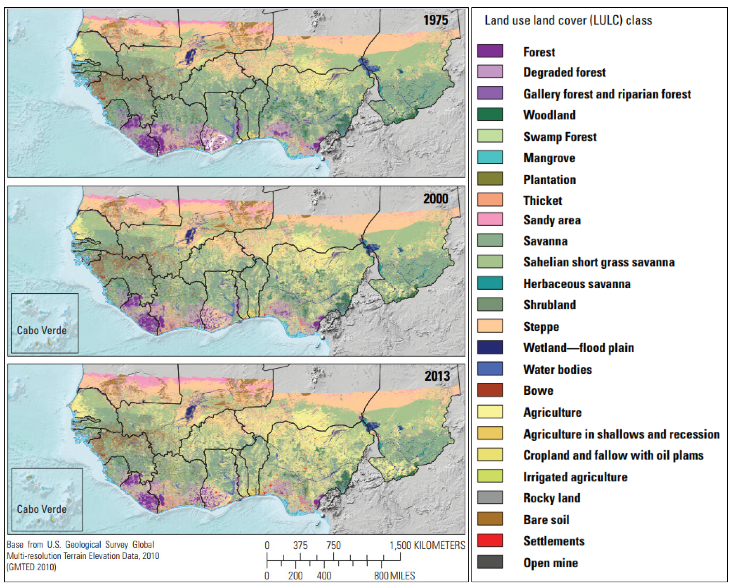
Figure 2.
Distribution of actual responses to the questionnaire.
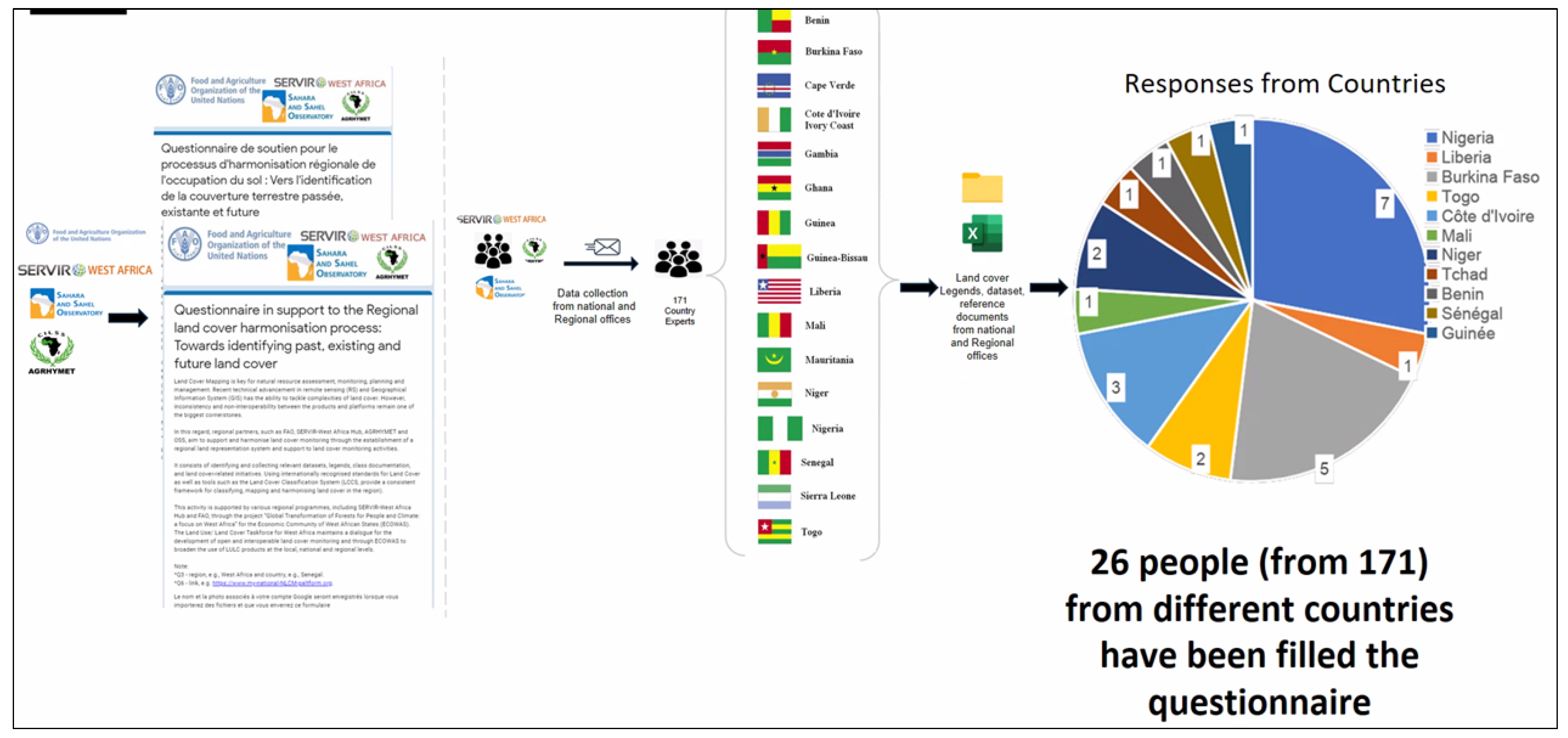
Figure 3.
Respondents who have contributed to land use and land cover activities and used the FAO Land Cover Classification System (LCCS).
Figure 3.
Respondents who have contributed to land use and land cover activities and used the FAO Land Cover Classification System (LCCS).
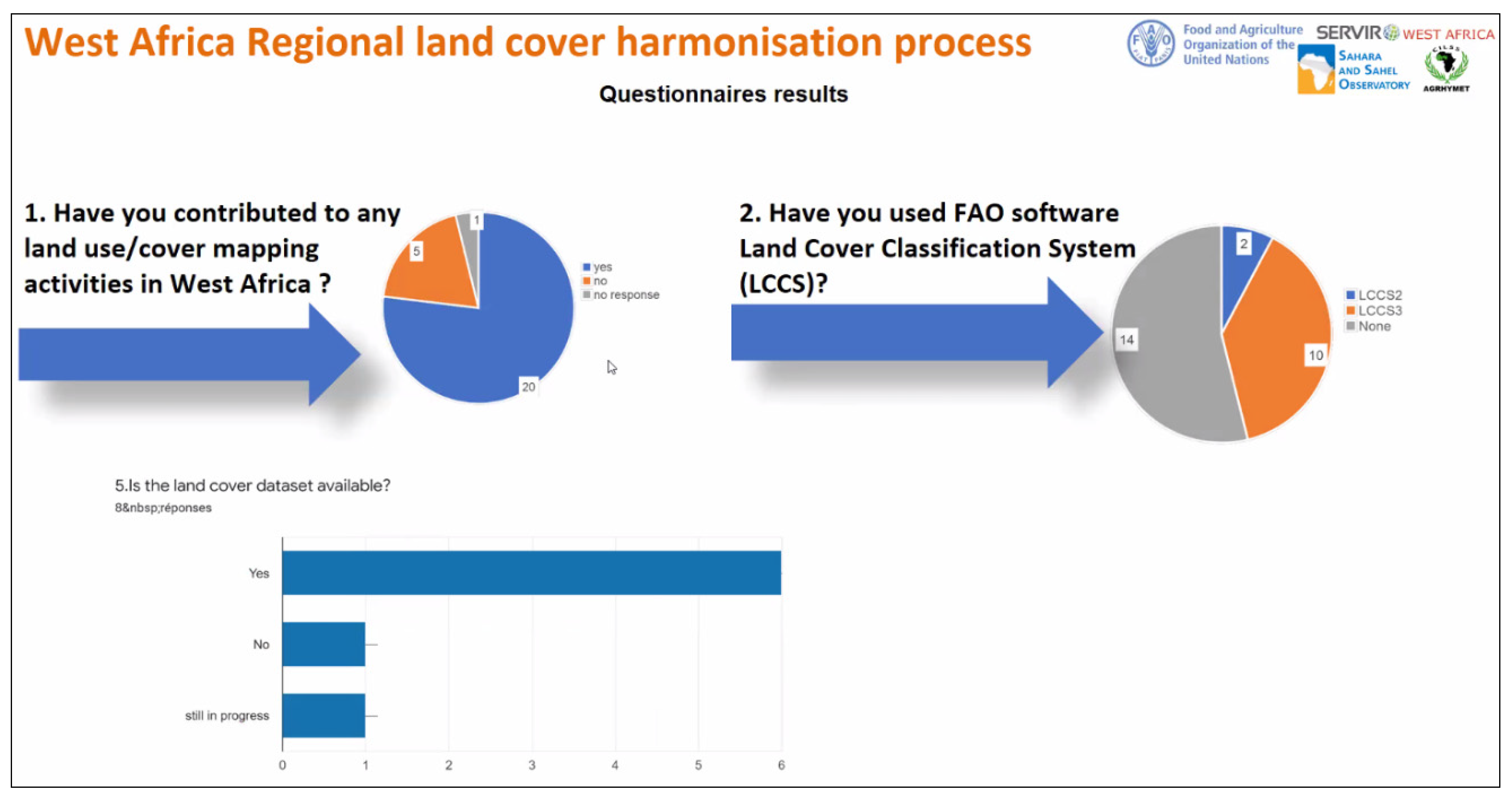
Figure 4.
Available and accessible land cover legends and datasets in West Africa.
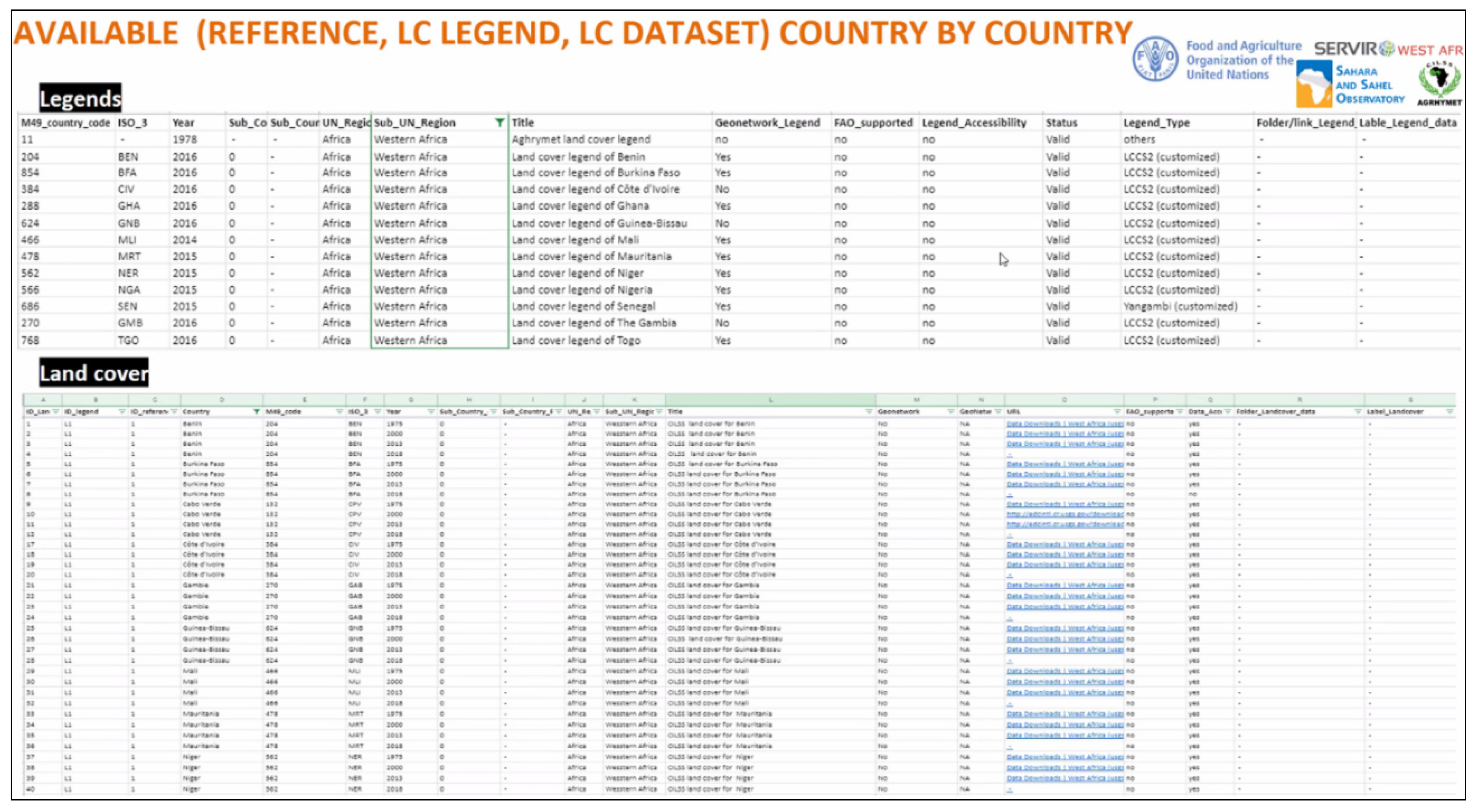
Figure 5.
Description of a land cover class for a tree and shrubs savanna [15].
Figure 5.
Description of a land cover class for a tree and shrubs savanna [15].
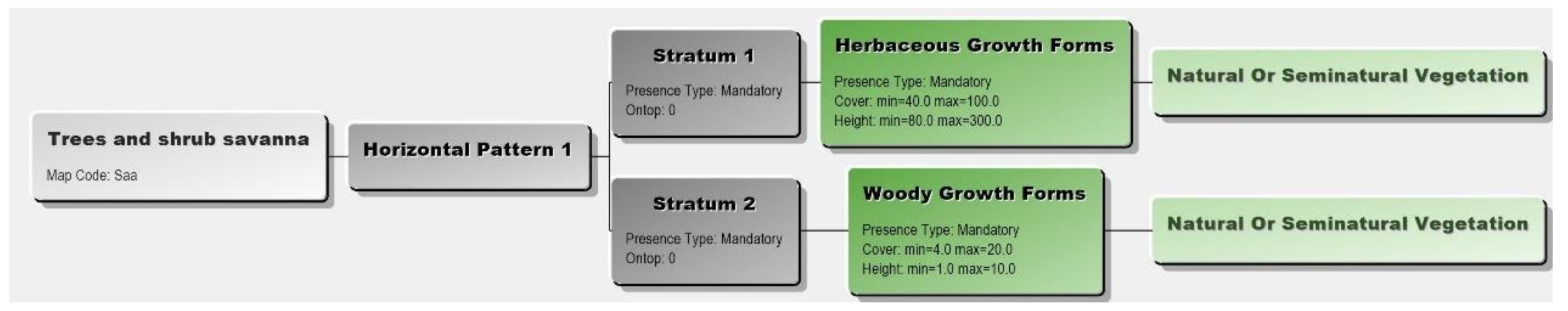
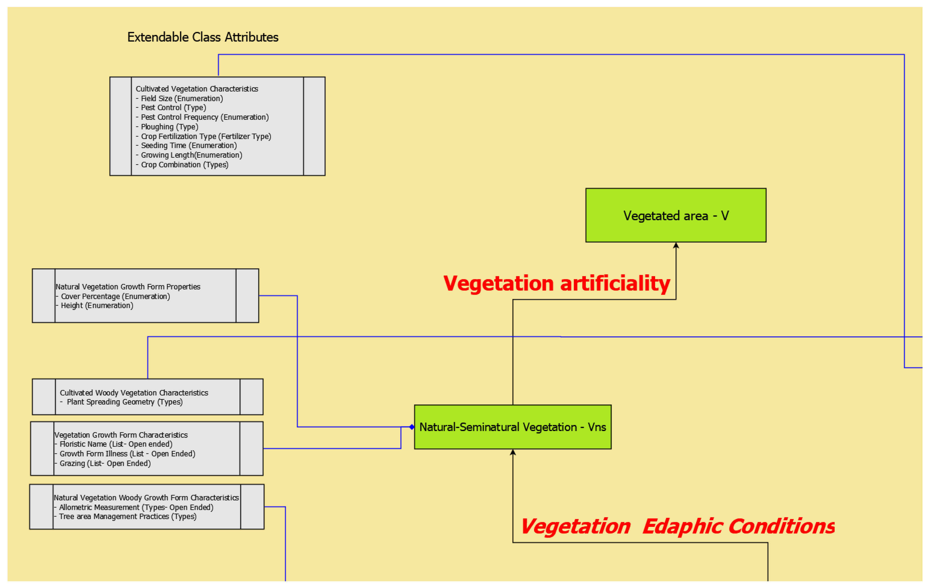
Figure 6.
An illustration of the land cover meta-language attributes [15].
Figure 6.
An illustration of the land cover meta-language attributes [15].
Disclaimer/Publisher’s Note: The statements, opinions and data contained in all publications are solely those of the individual author(s) and contributor(s) and not of MDPI and/or the editor(s). MDPI and/or the editor(s) disclaim responsibility for any injury to people or property resulting from any ideas, methods, instructions or products referred to in the content. |
© 2024 by the authors. Licensee MDPI, Basel, Switzerland. This article is an open access article distributed under the terms and conditions of the Creative Commons Attribution (CC BY) license (http://creativecommons.org/licenses/by/4.0/).
Copyright: This open access article is published under a Creative Commons CC BY 4.0 license, which permit the free download, distribution, and reuse, provided that the author and preprint are cited in any reuse.


