Submitted:
27 February 2024
Posted:
27 February 2024
You are already at the latest version
Abstract
In the digital era, enhancing the heritage resources of a tourist route means describing and networking them to promote their visibility and attractiveness. Prior studies mainly assess mountainous region’s natural resources through multi-indicator descriptive evaluation. This study aims to develop a comprehensive measurement of indicator’s value while assessing the tourism development potential of mountainous rural area. It concerns the main tourist route of the UNESCO M'Goun Geopark, located in the central High Atlas of Morocco. It also involves analyzing the criteria for choosing this destination by segmenting tourists' consumption experiences. Statistical analysis of the collected data reveals five dimensions of destination choice and four visitor groups. This article proposes to discuss findings and their applicability in terms of tourism destination management and decision-making, which can help local governments to rationally allocate tourism resources and land use.
Keywords:
Geomorphology
; Geotourism
; Digital promotion
; Visitor typology
; Local development
; Central High Atlas
; Morocco
1. Introduction
The central High Atlas region of Morocco (Figure 1a) is a mountainous area with natural and cultural resources that have the potential to become a world-class tourist destination. It contains the M'Goun Geopark, which was included in the UNESCO Global Geopark Network in 2014. Unfortunately, the region's tourism potential is not fully exploited and the international visibility of its tourist circuits and sub-circuits is barely average.
In the digital era, enhancing the value of heritage resources on a tourist route starts with their description and networking to increase their visibility and appeal. Analyzing the criteria for choosing a destination is essential for identifying its strengths and weaknesses, so that they can be considered in territorial planning policies. This study aims to strengthen the tourist appeal of the central High Atlas region in Morocco by highlighting its resources via innovative technologies, and to gain insights into the needs and expectations of tourists based on the experiences of 767 respondents who have visited all or part of the studied circuits and sub circuits.
Following this research idea, our study consists of two parts: first, we provide an objective description of the natural resources, in particular the geological, geomorphological and landscape resources of the central High Atlas region. Among thirteen geomorphosites (Figure 1b) described along the studied tourist route, we have chosen to present in this article three of them to illustrate the diversity and uniqueness of these resources. The data sheets, photographs and shapefiles produced for each site have been incorporated into algorithm developed using R software [1,2]. As a result, a database of tourist resources in the region has been created. This can be used to develop a website, an interactive apps and/or portal for the studied circuits and sub-circuits with sufficient information needing by tourists. The second part of this study analyses the typology of visitors to the central High Atlas region, using an experiential approach to tourism consumption. We have therefore carried out a quantitative assessment and analysis of 34 motivational and destination criteria. This has enabled us to better understand the needs and expectations of tourists seeking to visit the region.
From an academic point of view, the first part of our research builds on previous studies exploring qualitative assessments, allowing the authors to propose a classification of geosites, geomorphosites or even geoparks [3,4,5,6,7,8,9]. Our contribution enriches the literature as previous studies in this field in Morocco are very rare, old, large-scale, and focused on the creation of parks and protected areas in the High and Middle Atlas Mountains and on the Moroccan coast (e.g., [10,11,12,13,14]). Prior studies mainly assess mountainous region’s natural and cultural resources through multi-indicator descriptive evaluation. The weakness of this method lies in the transcription of the qualitative description of each indicator to a quantified ratio allowing a judicious rating to be assigned to the studied sites. This study aims to develop comprehensive measurement of indicator’s value while assessing the tourism development potential of mountainous rural area. We adopt a quantitative and experiential approach to analyze the destination choice criteria. Indicators assessed have been organized in factor layers and then assigned values based on field surveys and on the appreciation of tourists who had experienced the studied tour and related trekking activities.
From a managerial point of view, the first part of our research enables us to produce descriptive documents and “IT” supports that can directly be used by tourism operators. Detailed descriptions of the natural tourist heritage produced by expert scientists but written in an easily comprehensible way, would feed tourist guides’ speeches, texts, and images on the related websites of tourist agencies. These are often poorly documented. The aim of the second part of our research, based on data from a field survey, is twofold: to quantitatively assess the weight of each motivational and choice criterion for the central High Atlas tourist destination in Morocco, and to determine the extent to which the main dimensions of experience can be used to segment consumers. This will enable tourism operators in the region to better understand the respective motivations of each segment (group) and consequently adapt the tourism offer to their needs and expectations.
Sociodemographic and statistical studies of mountain tourism clientele have highlighted the influence of various factors on the process of choosing this destination [15,16,17,18,19,20,21,22]. In addition to factors related to the nature and characteristics of the places and territory to visit, individuals often express psychological needs for emotion, hedonism, and sensation. Most of these studies show that tourists are not only looking for an extraordinary experience. They also want to be active creators and producers. According to [23], destination choice is the result of internal factors related to individuals and their motivations, as well as external factors related to destination characteristics. Similar studies [24,25,26,27] show that tourists are mainly looking for memorable experiences when choosing mountain destinations. The authors conclude their studies by suggesting and recommending that tourism companies focus on activities that evoke such emotional states and develop experiential marketing that offers customers immersion in extraordinary experiences rather than the purchase of simple products or services. Other segmentation studies in the tourism sector use demographic and geographic criteria, as well as psychographic behavior related to people's personalities and lifestyles, to identify market segmentation [27,28].
Therefore, the literature review on the influence of consumer behavior on destination choice shows that mountain tourism operators have much to gain from understanding how their offer fits into a more global and personal project for their customers. Segmenting the consumer market into homogenous groups according to different behavioral criteria would enable tourism operators to develop targeted marketing. The list of criteria for motivation and choice of tourist destination in the central High Atlas, which was the subject of our field research, was partly inspired by the literature review, but also considers the specific natural (geosite, biodiversity and geomorphology) and cultural characteristics of the studied area community. The visitor typology revealed by our study shows four different groups: young and sporty visitors, family groups and passive tourists, visitors looking for leisure activities and geo-tourism enthusiasts. This work proposes to discuss the obtained results and their applicability in terms of tourism destination management and decision-making, which can help local governments and operators to rationally allocate tourism resources and land use.
2. Research Method
2.1. Tourism Resources Database
The objective of this work is to contribute to enhancing and making visible natural heritage resources of the central High Atlas Mountain of Morocco. As part of this study, we produced thirteen technical fact sheets. These summarize sites that can been considered representative of the studied region. Three geomorphosites (IminIfri (1), AitBouhuemez (6) and Imsfran (11) (Figure 1b)), located respectively at the beginning, the middle, and the end of a 640-kilometre tourist circuit, considering the ochre city of Marrakech as departure and arrival point. Those sites have been selected to illustrate the beauty and uniqueness of the studied mountain touristic circuit. The description have been written by academic and university experts, but the text is in a very simple style to make information and images more accessible to tourists whatever their educational level. Each sheet focuses on the following items: coordinates, access, geological and geomorphological description, striking effect, and representativeness of the site (e.g., section 3.1.). Then, for each site, the text was supported by photographs and video clips that had been converted into the URL format and for which links had been created.
Simultaneously, we developed an algorithm using R software [1,2] to visualize and carry out a cartographic analysis of the data relating to the above-mentioned heritage resources. This algorithm translated into R language allows structuring and displaying our data on an interactive map (Figure 2). The output document is downloadable and easy to use. Tourists can then click on the desired location and get all information they need to make their experience informative and enjoyable.
2.2. Quantitative Evaluation of Destination Choice Criteria and Tourist Typology
The literature review on the attractiveness of mountain tourist circuits around the world has enabled us to draw up an initial list of criteria for choosing such destinations. Other criteria specific to the central High Atlas Mountain of Morocco have been added to this list following an initial series of interviews conducted either face-to-face or via WhatsApp with tourism professionals and operators in this region. They are mainly guides, managers and/or owners of accommodation, but also tourists we met during our several field trips. Face-to-face interviews have already made it possible to identify the essential needs sought by visitors when choosing the destination of the studied circuit and sub-circuits. In addition to describing in detail their experiences of visiting the circuit, the interviewees also helped us to draft a questionnaire designed to assess the criteria used to motivate and select the central High Atlas as a destination. This enabled us to select 34 criteria for this quantitative assessment.
The questionnaire was then the subject of a fifteen-month field survey (June 2022 to September 2023). Interviews were conducted either face-to-face or via email, WhatsApp, or Facebook. People interviewed face-to-face were either tourists, mainly foreigners, whom we met on the circuit during field visits, or persons we met at the 10th International Conference on UNESCO Global Geoparks 2023, held in Marrakech from 5 to 11 September 2023. They are also professionals (guides, hostel managers, lodging managers or owners) contacted on the field or at their tourism agencies in Marrakech. All the people interviewed completed a questionnaire previously drawn up for the survey. The same questionnaire was also, made available online via Goole Forms application and shared on social networking sites. In addition, an URL link to the questionnaire was created and sent by e-mail to 117 persons whose activity is fully or partially linked to rural tourism in the Moroccan central High Atlas Mountain. We also asked anyone contacted via social networks, email or face-to-face to distribute the questionnaire to their network (Facebook discussion group, WhatsApp groups, members of associations, specialist discussion forums, etc.).
Respondents have been asked about two aspects of information seeking. First to answer questions about themselves: professional or ordinary visitor; gender; from Morocco or abroad; individual or group trip; the number of sites visited among the thirteen selected in this study and finally the duration of the experience in the studied tourist itinerary. These qualitative criteria have been considered as modalities in our statistical data analysis. Each person was then asked to rate each of the 34 surveyed criteria on a scale of 1 to 5. We have deliberately used the same rating scale in order to be able to make a comparative analysis of the weighting of the criteria in the consumer experience sought while visiting the studied circuits and sub-circuits. Quantitative variables thus measured were used for the statistical analysis of the collected data.
The data were analysed using R software, mainly the FactoMineR [29] and factoextra [30] packages. These two tools are very appropriate and easy to use for carrying out a high-performance Principal Component Analysis (PCA). PCA is a multidimensional reduction method commonly used in data analysis to extract and represent the information contained in large datasets such as our case. We started by importing our data into the R environment and then proceeded to prepare it for analysis by performing data cleaning and processing tasks. We then performed the PCA using FactoMineR and the factoextra package to produce high-quality graphs to visualize the results of our analysis.
The objective in our case study is to examine when the individuals approached are similar from the point of view of the assessment of the variables. Moreover, if several individuals are similar, can we construct groups of individuals and thus build a clustering of the studied sample? Our aim is to identify a typology of Central High Atlas visitors, i.e. homogeneous groups from the point of view of all considered variables. The standard methods most commonly used in multivariate data analysis are Principal Component Analysis [31], hierarchical clustering [32] and the k-mean method [33]. We chose the HCPC (Hierarchical Clustering on Principal Components) approach, which combines the three methods mentioned above [34], due to the nature of the data collected. We also analysed the linear relationships between the studied variables and determined the corresponding correlation coefficients using the Person's method [2]. This enabled us to group highly correlated variables into dimensions. The outcomes of all the aforementioned statistical analyses are presented in clear graphs.
In total, we were able to record the responses of 767 people who completed our questionnaire. After a descriptive analysis of this sample, we carried out a HCPC analysis on the 34 variables considered in our field survey to extract the main dimensions of the desired consumer experience. We converted the total score for each criterion into a percentage of the weight it represents as a source of motivation for the experience. This weighting can also be considered as a measure of the influence on the choice of the destination for the tourists who will be having this experience in the future.
The nature of the criteria used for the survey makes it impossible to separate the influence of visitor behavior and internal needs from that of the attributes of the region. The desire to escape into nature and admire the majesty of the high peaks, which is an internal behavior of the tourist, can only be satisfied by the splendor of the panoramic views offered by the studied area. We therefore assigned each criterion (variable) to a family or "Factor". The weight that each "Factor" represents in the dimension of the consumer experience sought by visitors was determined. The weights of the 34 studied criteria were then standardized by recalculating their internal weights within each "Factor". Thus, the sum of the internal weights of the criteria belonging to the same “Factor” must equal 100% and the sum of the "factors" must also equal 100%. The following section shows the allocation of the evaluated criteria to the different "Factor" and the code assigned to them in this evaluation.
3. Results
3.1. Geomorphosite Features
Thirteen geomorphosites data sheets have been compiled. Datasheets can be accessed by clicking on the relevant site marker on the interactive map generated using R software. In this work, we present only the study of 3 geosites, namely: Imin-n-Ifri, Ait Bouguemez valley and Imsfran cathedral (Figure 1b; 1, 5 and 11).
3.1.1. Imi-n-Ifri Natural Bridge (X=6° 58’ 18 ’’ ; Y=31° 43’ 26’’ ; Z=1069 m)
After leaving the village of Demnate, the R307 road passes through a forest of mainly juniper trees on a substrate of red clay and weathered Triassic basalt [35,36,37,38,39]. With no piers or abutments, the Imin-n-Ifri Natural Bridge is a purely natural crossing (Figure 3a,b). The R307 passes through a magnificent natural cave open on both the north and south sides, formed in travertine limestone with a thickness of over 50 meters. It is possible to go down to the bottom of the talweg and admire the figures of this natural arch by taking a small path with pseudo-stairs. From the cave floor, it is easy to reconstruct the stages of travertine formation in a geological context dominated by Lower Jurassic carbonates (-180 Ma, [35]), as shown in the simplified geological section (Figure 3c). At Imin-n-Ifri site, the process of travertine formation took place during the Quaternary period (-0.5 Ma).
Travertine has a yellow or brown color and a vacuolar aspect. Once altered, the rock takes on a tuffaceous appearance. This type of rock develops in regions where carbonate (CaCO3) formations are dominant. The leaching of the latter by meteoric waters, often aggressive, dissolves the chemical elements in the rock (Ca2+ and HCO3-) and, once saturated, precipitates them in sources or river waterfalls. The cave has some very fine stalagmites and stalactites figures. The environment in which travertines form is often a good habitat for bacteria and algae. These help to precipitate calcite and calcify the rock as it forms. So that, the rock retains what we know as a stromatolithic appearance, with traces of seasonal activity and leaching-precipitation cycles [40,41].
Passing under the natural bridge, which is 50 m lower than the roadway, at the northern exit of the cave we find large water springs, located stratigraphically at the contact between the Triassic red clays and the overlying Lower Liassic limestone beds. At this place, it is easy to see that the flow of the river that has shaped the travertines has increased at least tenfold, following the appearance of springs fed by the karst network that has developed in Lias and Dogger limestones. Stairs built into the northern slope of the Imin-n-Ifri natural bridge site lead up then to the roadway. On the way up, you can also appreciate the local biodiversity, especially the colonies of swallows, crows, and raptors.
Continuing along the R302 for 6 km, you will reach the site of Iwariden with its dinosaur footprints. The site is located just 20 meters from the road (X=31°43’, Y=6°54’, Z=1751 m). It shows tracks with superb dinosaur footprints perfectly preserved in open, hardened and cracked surfaces (mudcracks) of a Middle to Upper Jurassic red silty sandstone formation(“Couches Rouges” formation) ([36,42], -160 Ma). Two types of footprints can be distinguished, large oval ones that are related to the feet of large herbivorous dinosaurs and smaller ones resembling bird feet (tridactyl, three toes) attributed to smaller carnivorous dinosaurs [43] (Figure 3d). The presence of these traces in this red continental formation clearly indicates the environment that prevailed in this region of the High Atlas 160 million years ago. [44] attribute these footprints to Megalosauripus, a bipedal theropod’s dinosaur with an average height of 1.5 to 2 meters, abundant in several regions (Portugal, Spain, America, Morocco, etc.) that were very close to each other during the Jurassic period. An unique geological heritage to preserve and to enhance, for more geo-touristic promotion.
3.1.2. Ait Bouguemez Valley (X=6°31’38’’ ; Y=31°37’59’’; Z=2080 m)
A trip to the joyful valley of AitBouguemez, situated at 1800 m rise in the Moroccan central High Atlas Mountain, offers a completely natural encounter. At the slopes of the majestic M'Goun, Azourki and Rat mountains (Djebels), erosion has carved out a thirty-kilometer-long valley, which is now a beautiful garden where the magic of color expresses through different shades of green terraced crops, pure white of the snow on the peaks and dazzling blue of the sky (Figure 4a). This valley houses 27 villages perched on mountain slopes dominating fields of wheat, barley, and maize. The dwellings of the Amazigh community (15000 inhabitants) are made of clay and have green roofs. They are mainly built around granaries, called tighremts in Amazigh, the largest of these is that of Sidi Moussa. These granaries had been building using traditional methods to store harvests. The variety of forms and the abundance of designs are examples of a cultivated creative ethos. They are also examples of a communal, democratic outlook. This fortified collective building is a unique and an example of local Amazigh heritage, with a rich history and insight into their agricultural, pastoral, and artisanal lifestyle.
During the winter season, when the snowfall is abundant, enthusiasts are well-catered for on the slopes surrounding the valley, which offer well-cut natural sky trails. In spring, visitors can enjoy a real escape into pure nature, walking along easy paths that emerge from fields, which are a true mosaic of breathtaking colors. Several easy walks and mountain bike routes are available in the valley, following the happy river through Arous canyons and waterfalls (Figure 4b). The mountain lodges, which welcome thousands of tourists every year, also offer more difficult hikes, such as the ascent of Djebels M'Goun (4068m), Azourki (3677m) and Rat (3797m), or longer circuits, such as from AitBouguemez to Tassaout river, near Demnat (10 days), or from the valley to Imilchil village (12 days).
The AitBouguemez valley is rich and contains numerous geological sites of great interest, as well as ecological, archaeological, historical, and cultural value. From a cultural point of view, the ancestral populations living on this territory are very welcoming and always happy to share their ethnological, culinary, and musical traditions. Locals are interested in visitors' curiosities, while carefully preserving Berber culture. Visitors can appreciate these traditions at Tabant market located in the centre of the valley, as well as in the self-catering cottages and guesthouses. Tourists are often invited to participate in indigenous cultural activities presented by local groups, such as the famous "Boughanim".
The geomorphology of the AitBouguemez region is strongly influenced by the geological structure: The anticlinal axes form elongated summit ridges, while the main valley and its satellites lie in the center of the synclines. Inverted reliefs with perched synclines (e.g., Jbel Rat), and various erosional gullies and ravines, such as Arous, can be a delightful sight in this region. In some places, such as at the south-west entrance to the valley, steep, almost inaccessible cliffs overlook the road. These cliffs and ledges are made up of huge limestone blocks from the Ait Abdi Formation, which dates back to the Aalenian-Bajocian period (over 170 million years ago, [45]). Some glacial deposits (pale pink) can be seen at the base of the slopes, allowing us to reconstruct the freeze-thaw cycles that provided the valley with nutrient-rich Quaternary deposits.
From a geological point of view, the AitBouguemez valley, which is part of the large UNESCO M'Goun Geopark, contains several geosites of exceptional interest. There are numerous dinosaurs’ tracks and rock carving. In the village of Ibakliwine, located almost at the bottom of the valley, you can observe two types of dinosaurs’ trace on a slightly sloping limestone stratum: large oval tracks from gigantic herbivorous dinosaurs and tridactyl tracks from carnivorous dinosaurs (Figure 4c). These footprints date back 180 million years when this region consisted of muddy lagoons that were inhabited by groups of dinosaurs [46]. At Tizi-n-Tighist, there are also engravings depicting horsemen with spears and shields, indicating scenes of invasion, combat, and hunting, engraved on Triassic sandstone from around 3,500 to 4,000 years ago (Bronze Age) (Figure 4d).
3.1.3. Imsfran Cathedral (X=6°8’55’’; Y=31°59’37’’; Z= 1272 m)
Situated towards the end of the studied tourist circuit between the famous Zaouiat Ahansal and Tilouguite villages, this spectacular natural site is an imposing cliff overhanging Oued Ahansal for more than 600 m (Figure 5). This huge rock formation, which dates from the Miocene to the Pliocene (2 to 10 million years ago, [47,48,49]), is made up of conglomerates and sandstones. These sediments have been produced by the Atlas relief erosion. They have been in turn sculpted by this process, shaping them into an impressive silhouette of a medieval church, and from this come the name of the “cathedral” given by [50].
The site of Imsfran is remarkable not only for the splendor of its geological formations, but also for the contrast of its colors: brown of the rock, green of the Aleppo pines and red earth in places. Fabulous memories photographs can be taken of the site from the surrounding peaks. The area attracts both amateur hikers who want to admire the panoramic view from the base of the cathedral, and experienced hikers who make their way to the summit. Others explore the gorges of Oued Ahansal, where the high limestone cliffs gradually narrow to offer spectacular and sublime views of the river. During spring, when the snow melts, the river attracts rafting and canyoning enthusiasts. Other enthusiasts come to fish for the abundant trout and salamon in this river.
Unfortunately, the three sites described above and the ten additional surveyed (Figure 1b) are not well-known to either local or international tourists. Their visibility would have attracted lovers of nature and panoramic landscapes to these small, discreet corners of the central High Atlas, to delight in the absolute charm of nature and enjoy new adventures and experiences. This might have attracted nature lovers and those seeking panoramic landscapes to this small, discreet corner of the central High Atlas, where they would experience the absolute charm of nature and be enchanted by their new adventures. The digital documents produced and networked as part of this study are a modest contribution to enhancing these tourist resources by embedding their visibility. We are also working on setting up a website for the tourist circuit studied, which will include all the digital documents produced. This site will be hosted by accommodation providers to highlight the wealth and potential of tourism in the Central High Atlas region of Morocco. In the next section, we examine the findings of a field survey carried out to gain a better understanding of the wishes of Moroccan and foreign visitors to the region. The results of such surveys are extremely useful in order to better adapt the tourist offer, consolidate the region's strengths, and improve its weaknesses.
3.2. Quantitative Experiential Analysis of Attraction Criteria
Table 1 is a descriptive analysis of the sample of respondents to our questionnaire. It is easy to see that the sample consists mainly of younger people (more than 62 % are less than 45 years old) and men (66.62 %). Typical visitors to the studied circuits and sub-circuits come in groups of friends (62.71%) and stay in the area for at least two days (over 85%). Over 78% of visitors to the study area had the opportunity to visit at least three geomorphosites among the 13 selected for this study. It is also clear that, despite the efforts made to ensure the widest possible diffusion of our questionnaire, which was posted online on the Google Forms application and on social networks for about 15 months, few foreign visitors responded to our request (16.95% only). The studied mountain tourism circuit is probably not very well known or internationally marketed.
No unusual individuals were identified when analyzing the graphs using R software. All responses were therefore part of our statistical analysis. Conformity and homogeneity tests of the quantitative variables did not either exclude any of them, therefore all the studied variables have been considered in the quantitative analysis of the collected data. Table 2 shows each variable's overall score, mean, standard deviation and weight in respondents' choice of destination and experience. We can clearly see that, apart from an average standard deviation for the variables V12, V15, V16, V110, V111 and V33, the visitors' assessments of all the other variables are concentrated around the mean value. Responses are so not random, which reassures the quality and reliability of this study's findings.
Interactive statistical analysis using R software and calculation of Pearson's correlation coefficient [2] (Figure 6a) enabled us to group the variables studied into five dimensions (Factors). These dimensions interpret visitors' needs and desires when choosing the central High Atlas tourist circuit and sub-circuits. The description of each dimension and the weight it represents in the destination's attractiveness are detailed in Table 2.
The "attributes of the territory and individual behavior" factor accounts for more than a third (36.96%) of the weighting in the choice of the Central High Atlas as a tourist destination. It explains the basic needs and requirements of visitors to high mountain tourist destinations. This shows that rural tourism in mountain areas is a complex offer. It must cover all aspects of access to the area, safety, and a feeling of pleasure and hedonism. The internal consistency between its 13 variables is satisfactory (0.87 on average). These variables are thus clearly associated with this factor.
The 'cultural wealth and hospitality of the local people' factor was ranked second. This shows that visitors to the Central High Atlas region not only come to admire the pristine natural environment in a context of safety and availability of basic services, but are also attracted by the cultural richness, simple lifestyle, and hospitality of the local Amazigh population. With a score of 20.11%, this dimension explains the tendency of visitors to make direct contact with the locals, share pleasant moments with them, and get to know their customs, traditions, and lifestyles. Correlation between variables in this dimension is very satisfactory (0.91). This is in accordance with the current trend toward sustainable rural tourism.
The geographical aspect of the area and the splendor of its views are also very important in terms of tourist attraction. Despite the limited number of variables attributed (only six variables) to the third dimension (Factor: beauty of landscape resources), its weight is 19.16%.The fourth dimension, consisting of five variables, deals with the contribution of the geological heritage to attracting tourists to the central High Atlas region (geotourism). This alone represents a weight of 13.92% and shows that visitors increasingly know the value and uniqueness of the region’s geosites, especially since the M'Goun Geopark has been awarded the "Global Geopark Network" label by UNESCO in 2014. However, given the uniqueness and international representativeness of the region's geosites, we believe this weighting remains moderate. As a result, the region's geological heritage is not well known. Considerable efforts need to be made to improve its visibility. Finally, the fifth dimension involves biodiversity in the choice of destination. Getting to know the vegetation and seeing how species are distributed according to altitude also motivates visitors. This dimension has a weight of 9.85%.
Before proceeding with the PCA analysis of the collected data, we performed an inertia distribution analysis, which indicates whether the variables are structured, and suggests the appropriate number of principal components to examine. This operation carried out using R software shows (Figure 6b) that the first 2 factorial axes express 44.94% of the total inertia of the dataset. This means that 44.94% of the total variability of the cloud of individuals or variables is represented in this plane (Figure 6c). This is a relatively average percentage, and the foreground represents only part of the variability in the whole active dataset. It would therefore be useful to include at least axes 3 and 4 in the PCA analysis.
To facilitate correspondence between groups and field survey modalities, we characterize each corresponding point cloud by its barycenter (Figure 7a).PCA analysis highlighted four groups of individuals (clusters, Figure 7b).We observe, for example, that foreign visitors and those coming with their families are almost all in group 2. Young people under the age of 45 are more likely to be in group 1.
- 1.
- Young sportsmen and women with a passion for the challenge of summit conquest
They are young people under the age of 45. Adventure and the feeling of conquering the region's peaks, the quest to surpass oneself, and the experience of escape are their main inspiration. Individuals who cannot been considered as passive beings, but rather as designers and producers of their own sensations constitute this group. They travel with friends and are often organized into hiking groups. They come to feel free in a mountain environment, with the feeling that they are being sporty.
The visibility of this group on social networking sites was very useful for us in terms of their participation in our survey. This group is the largest one of visitors to the central High Atlas region, accounting with 62.71% of the studied sample. They scored highest on variables V15, V18, V19, V24 and V25, which correspond respectively to the criteria "Feeling of overcoming the difficulty of the hike", "Pleasure of walking in virgin nature", "Leisure activities and entertainment", "Feeling the majesty of high peaks" and "Discovering unspoiled nature". This shows that the main reason they come is to test their sporting skills, to celebrate with their friends and to admire the majesty of the summits. Most of these were respondents who had visited more than 6 of the 13 geomorphological sites examined in this study. For instance, they are only moderately culturally interested: the average score of the group on the variables in the fifth dimension was 4.32, while the average score for the entire sample was 4.79.
- 2.
- Families and passive tourists inspired by culture and landscape
These are discerning customers in search of an experience in unspoiled nature but with basic service and safety conditions. They scored high on variables V11, V12, V13, V14, V17, V18, V19, V112, V113, V21, V25, V32, V42 and all variables in the fifth dimension (see Table 2). This shows that this group comes to explore the area in their own 'calm and quiet' way, maintaining a relationship with the environment. One of things they want to achieve is to interact socially. Most of them stay more than 48 hours in the region. Foreign tourists and Moroccan visitors who come with their families dominate this group. Contrary to the group "Young sportsmen and women", this group is predominantly represented by an older clientele (over than 65 years old) with a relatively high percentage of women (59/141 or 41.84%). This group represents (18.39%) of individuals in our sample.
- 3.
- Geotourism enthusiasts
This group scores high on V21, V25, V32, V35, V42, V51, V53 and V56. It represents a customer that seeks to combine natural, cultural, and geological environments when they choose to travel. Their stay in the area varies from 48 to more than 72 hours. This shows that these visitors take time to analyse the geomorphology and the uniqueness of the geological sites along the tourist route. They also prefer to stay with the locals as much as possible to discover and appreciate the cultural heritage of the region. This group, which represents 10.7% of our sample, is probably composed mainly of specialists (geologists, sociologists, geomorphologists, etc.).
- 4.
- Visitors looking for leisure activities
They scored highly on variables V18, V19, V113, V42 and V43 and are therefore mainly looking for leisure activities (hunting, fishing, rafting, jet skiing, climbing, etc.). Getting away from it all is the main aim of the experience for people in this group. An educational component that engages the mind and body, such as learning a new hobby or discovering another culture through group activities, can enrich the experience. Their stay was fairly short (less than 24 hours) and they visited fewer than 3 of the 13 geomorphosites described in this study. This group accounts for only 8.2% of the studied sample.
Statistical analysis of the survey data has therefore made it possible to identify five dimensions of destination choice and four categories of visitor. The weights assigned to the motivational criteria and destination choice highlight the significance placed on the intrinsic attributes of the region: high-altitude peaks, magnificent panoramic views, cultural riches, and hospitality of residents. As well as the search for sensations, hedonism and image, customers also attach importance to culture and the specific geological and geomorphological features of this region.
Paradoxically, our results show that criteria relating to well-being and safety are not given too much consideration when choosing a destination. We explain this by the fact that visitors come in groups, mostly young people (group 1), and therefore have no concern for safety and well-being, preferring to camp out in the countryside. Group 3, predominantly comprised of leisure enthusiasts, spends only their daytime on certain sections of the tourist circuit before returning to the nearby main towns (Marrakech, Beni Mellal, or Azilal) for the night. Thus, there is no cause for concern regarding safety or the availability of essential services.
The second section of this study, using an experiential approach, allowed for objective measurement and quantification of visitor expectations when traveling to this destination. The approach was both deductive and quantitative. Firstly, the dimensions sought in the choice of destination (five dimensions) have been defined. Secondly, groups of visitors to the studied circuit were constructed (four groups). The findings possess a significant level of validity and allow for an investigation into the emotional and sensational factors influencing the selection of mountain tourism destinations in the central High Atlas of Morocco.
We believe that customer segmentation based on consumer experience is an extremely valuable tool. It allows for a more precise examination of customers' specific expectations and provides tourism operators with crucial insights when considering an appropriate offer. Based on tourist typology, these operators should focus on variables with the highest ratings to preserve and improve them. They should also work to enhance variables with the lowest ratings. In our case, there is a need to preserve and improve primarily the objective and rational variables. Emotional or sensational evaluations should not be excluded unless clearly labeled as such. These are the choice criteria for Group 1, which represents most individuals in our sample. Thoughts on how to reduce visitor dissatisfaction may also prompted by the results of this approach. In this regard, our findings corroborate and complement previous similar research into the evaluation of geomorphosites, mountain tourist routes, and profiling visitors to such destination [51,52,53,54,55,56].
4. Conclusions
Interestingly, the literature review shows that the value of a destination's resources has the highest contribution to its tourism development potential. This study, based on both a deductive and quantitative approach, proposes a comprehensive index system to assess the value of these resources: firstly, creating digital documents about these resources and publishing them online is a valuable contribution to enhancing their visibility globally as well as promoting central High Atlas as a tourist destination. Secondly, by using a robust method to process field data, we were able to propose a segmentation of tourists to this destination and uncover the main attraction criteria.
Thirteen informative factsheets have been produced and made available online via an interactive map for easy access by tourists. The document serves as a comprehensive guide for all visitors, highlighting the main geosites and popular tourist destinations in the region and providing a detailed analysis of the various aspects typically sought by tourists in mountainous areas: geomorphology, geology, biology, sociology, and culture. The factsheets are authored by academic specialists but presented in a suitable manner for general audiences. The content is unbiased and comprehensible, allowing readers without expert knowledge to access the information. Descriptions, photographic and auditory material produced for each site will be a great help in making the tour both informative and enjoyable. These materials can also be used as input for speeches in tourist guides and as text and images on tourist agency websites, which are often poorly documented.
The implementation of an experiential methodology to assess the tourism characteristics of the Central High Atlas region of Morocco is a notable aspect of our study. Based on a statistical analysis, we propose a classification of the weight of the criteria considered in motivating and selecting this mountain tourist destination, as well as a typology of visitors. Five significant dimensions control the motivation and choice of tourists, namely, visitor behavior related to the territory's characteristics, the territory's landscape value, the rich cultural heritage of the region and the geological and biological treasures of this area. The study reveals that their weights are 36.96, 20.11, 19.16, 13.92 and 9.85 %, respectively. The higher value of the dimension weight is, the better the resource is, and the stronger the tourism sustainable development ability is. On the contrary, the smaller the weight, the weaker the tourism development potential.
Sensational visitor behavior in relation to the area's attributes has the most extensive weight. This significant potential attraction needs to be exploited and further developed. The environmental aspect has the lowest ranking and necessitates efforts to enhance its prominence and the importance of its components. According to the order of the weights of each variable (criteria), those relating to the sensational and cultural aspects are the best rated. Paradoxically, the variable relating to accommodation capacity in the region owns the least impact. This can be explained by the fact that young people who do hiking and camping in nature dominate our study sample. The percentage of people who had an experience of less than 24 hours also explains this result.
The study also reveals that visitors to the central High Atlas destination fall into four distinct groups: young sportsmen and women out walking, passive visitors, geotourists and leisure visitors. They represent 62.71, 18.39, 10.70 and 8.20% respectively of the studied sample (767 individuals).
Such identification is very helpful in defining the exact positioning of the tourist offer of the area in order to improve it. It constitutes an essential basis for managing tourism destinations and making decisions, which can help local governments and operators to rationally allocate tourism resources and land use in a region that has excellent potential for tourism competition in the Mediterranean area. We believe that it is of great significance to accurately evaluate real tourism development potential of this region and promote its tourism resources. In this regard, the outcomes of our research can be exploited by decision-makers to promote the tourism potential of the central High Atlas region through digital documentation produced, as well as through the analysis of tourists' categorization and their expectations of a tourism encounter in this area.
There are, however, a few limitations to this study that could explored as promising directions for future research. The first limitation concerns the sample size, which comprises only 767 individuals despite considerable efforts over a period of 15 months to increase the number of respondents to our questionnaire. To increase the validity of a customer segmentation study based on consumer experience, it is imperative to use a larger sample size consisting solely of visitors, and to prioritize face-to-face interviews over Internet surveys. Data collection through online surveys is consistently unreliable [57,58,59,60,61,62]. This is the second constraint of our investigation, which relies on a sample of consumers and tourism operators (guides and accommodation owners), mainly recruited through social networks. In our opinion, the scores given to the 34 criteria by this body may influenced by their desire to promote the circuit and the region's tourist sites. In addition, some of the criteria in the questionnaire were not really been used.It would therefore be interesting to simplify the questionnaire by rephrasing some of criteria. It also would be interesting to extend this study to university students and schoolchildren to determine their expectations for the transformation of the studied circuit into an educational cornerstone.
In contrast, there are significant results that can contribute to the region's local economic development. Responsible of the eight administrative communes in the area, as well as tourism operators, should take inspiration from this to carry out the idea of All-for-One Tourism [63] in the whole area of the central High Atlas. They are call upon to work together to achieve an integrated and efficient vision for tourism development potential in this region. The principle of All-for-One Tourism can encourage the participation of the entire stakeholders, make full use of regional tourism economic management resources, and encourage all tourism-related enterprises and communes to participate in tourism development. To achieve this aim, it is imperative to incorporate novel digital technologies in each region-specific development action or program. Our research is a small advance in this way and warrants further exploration to establish the basis for digital tourism in the central High Atlas area. It aims to promote the deep integration of the Internet and tourism in the context of a digital world and thus contributes to enhance the ability of internet technology to tap the potential of tourism demand.
The potential tourism demand can be fully exploited through online tourism websites, which could increase the size of the target tourist market and enhance destination marketing. Therefore, all local mangers and tourism operators must promote technological innovation and improve tourism science and technology. It is crucial for example that destination residents have to be fully motivated to develop manages that can benefit from the facilities and services of self-sustaining tourist accommodation (e.g., Airbnb or booking). The popularity of online payment should also be encouraged among residents. Furthermore, residents and businesses must be assisted in also building build an eco-home [64].
Finally, considering the tourism dimension of the studied area as a flywheel for the economic development, this contribution represents a first attempt to analyze inner mountain area related issues with its potentiality. This study’s findings will be helpful for developing a cooperation mechanism and sustainable development, thus reducing poverty, and promoting the mountain revitalization of the central High Atlas region in Morocco. Its results and recommendations are applicable for mountain regions worldwide in general and other parts in Morocco in particular.
Acknowledgments
This research was carried out as part of the project APRD IMAPHOS, funded by OCP Foundation. Thanks are addressed to the tourist guide associations of the central High Atlas for their help and their technical assistance throughout our research. We’d like to express our gratitude to all those who responded to our field survey.
Conflicts of Interest
The authors declare no conflict of interest.
References
- Husson F., Lê S., Pagès J (2009), Analyse de données avec R. Presses Universitaires de Rennes. Package FactoMineR pour faire des ACP : http://factominer.free.fr/index_fr.html.
- R Development Core Team (2021).,R: A language and environment for statistical computing. R Foundation for Statistical Computing, Vienna, Austria. URL https://www.R-project.org/.
- Portal C (2010), Reliefs et patrimoine géomorphologique. Applications aux parcs naturels de la façade atlantique européenne. Thèse en Géographie. Université de Nantes, 2010. Français. ffNNT, 447p.
- OIRY-VARACCA M (2013),From trekking to heritage tourism: identity, a lever for the territorial reconstruction of the AïtBouguemez valley, High Atlas, Morocco. In: Collection EDYTEM. Cahiers de géographie, 14, 2013. 45-56.
- Tomić N.; Božić S (2014), A modified Geosite Assessment Model (M-GAM) and its Application on the Lazar Canyon area (Serbia). Int. J. Environ. Res., 8(4), pp.1041-1052. [CrossRef]
- Trukhachev A (2015), Methodology for Evaluating the Rural Tourism Potentials: A Tool to Ensure Sustainable Development of Rural Settlements. Sustainability 2015, 7, 3052-3070; [CrossRef]
- Slehat M. (2018). Evaluation of Potential Tourism Resources for Developing Different Forms of Tourism: Case Study of Iraq Al-Amir and its surrounding areas – Jordan. Thesis, edit. CatholischeUniversitat, Eichstätt, 2018, 285p.
- Tranquarda M., Riffonb O (2018), Démarche d’attribution du statut international de géoparc : proposition d’une méthodologie d’analyse multicritère pour l’évaluation du potentiel des territoires et l’intégration des objectifs de développement durable. Revue Organisations&Territoires, Volume 27, 1, pp. 1-20. [CrossRef]
- Neto de Carvalho C., Baucon A., Bayet-Goll A., Belo J. (2021). The Penha Garcia Ichnological Park at Naturtejo UNESCO Global Geopark (Portugal): A geotourism destination in the footprint of the Great Ordovician Biodiversification Event. GeoconservationResearch, 4(1):70-79. [CrossRef]
- Billand A. (1996). Développement touristique des parcs de montagne au Maroc : principes de zonage et d'aménagement / Tourismdevelopment in the mountainparks of Morocco : planning and zoning principles. In: Revue de géographie alpine, tome 84, n°4, 1996. pp. 95-108. [CrossRef]
- Cayla N., Duval-Massaloux M. (2013). Le géotourisme : patrimoines, pratiques, acteurs et perspectives marocaines. In: Collection EDYTEM. Cahiers de géographie, 14, 2013. Ressources patrimoniales et alternatives touristiques, entre oasis et montagne. pp. 101-116. [CrossRef]
- Mehdioui S. El Hadi H. ,Tahiri A. , Brilha J. , El Haibi H., Tahiri M (2020),Inventory and Quantitative Assessment of Geosites in Rabat-Tiflet Region (North Western Morocco): Preliminary Study to Evaluate the Potential of the Area to Become a Geopark. Geoheritage (2020) 12:35. [CrossRef]
- Ait Omar T,2021, Les géopatrimoines de la partie Nord-Est du géoparc régional du M’Goun (Moyen et Haut Atlas Central, Maroc) : Inventaire, évaluation et valorisation. Thèse de doctorat, Univ. Sultan Mouly Slimane-Univ. Angers, 500p.
- Elkaichi A., Errami E., Patel N (2021),Quantitative assessment of the geodiversity of M’Goun UNESCO Geopark, Central High Atlas (Morocco). Arabian Journal of Geosciences (2021) 14:2829. [CrossRef]
- Fodness D (1994), Measuring Tourist Motivation, Annals of Tourism Research, A Social Sciences Journal, Vol. 21 (3), pp. 555-581. [CrossRef]
- Oppermann M (1995), Travel life cycle. Annals of Tourism Research, Volume 22, Issue 3, pp. 535-552. [CrossRef]
- Gagnon S (2007), Attractivité touristique et « sens » géo-anthropologique des territoires. Téoros, 26(2), 5–11. [CrossRef]
- Dupeyras A., MacCallum N (2013), Indicators for Measuring Competitiveness in Tourism: A Guidance Document, OECD Tourism Papers, 2013/02, OECD Publishing. [CrossRef]
- Boley B.-B.; Nickerson N.-P. (2013),Profilinggeotravelers: An a priori segmentation identifying and defining. sustainable travelers using the Geotraveler Tendency Scale (GTS). J. Sustain. Tour. 2013, 21, 314–330. [CrossRef]
- WallissJ.,Kok K (2014),New interpretative strategies for geotourism: an exploration of two Australian mining sites, Journal of Tourism and Cultural Change, 12:1, 33-49. [CrossRef]
- Ólafsdóttir R., Tverijonaite E (2018),Geotourism: A Systematic Literature Review. Geosciences 8(7):234. [CrossRef]
- Zhang Y., Linjie Jiao L., Yu Z., Lin Z., Gan M (2020), A Tourism Route-Planning Approach Based on Comprehensive Attractiveness. IEEE Access. [CrossRef]
- Pearce P.-L., Lee UL (2005),Tourist behavior: Developing the travel career approach to tourist motivation. Journal of Travel Research, Vol. 4, N° 3, p. 226-237. [CrossRef]
- Morgan M., Lugosi P., Ritchie Brent J.-R (2010),The Tourism and Leisure Experience: Consumer and Managerial Perspectives. Annals of Tourism Research 38(3):1205–1206. [CrossRef]
- Chen C. M., Chen S. H., Lee H. T (2011),The destination competitiveness of Kinmen’s tourism industry: exploring the interrelationships between tourist perceptions, service performance, customer satisfaction and sustainable tourism. J. Sustain. Tour. 19, 247–264. [CrossRef]
- Duglio S., Bonadonna A., Letey M., PeiraG., Zavattaro L. and Lombardi G (2019),Tourism Development in Inner Mountain Areas—The Local Stakeholders’ Point of View through a Mixed Method Approach. Sustainability 2019, 11, 5997; [CrossRef]
- Cao Q., Sarker M., Zhang D, Sun J., Xiong T., Ding J (2022), Tourism Competitiveness Evaluation: Evidence From Mountain Tourism in China. Front. Psychol. 13:809314. [CrossRef]
- Rid W., Ezeuduji O.-I., Probstl-Haider U (2014), “Segmentation by motivationfor rural tourism activities in The Gambia”, Tourism Management, Vol. 40, pp. 102-116. [CrossRef]
- Le S, Josse J, Husson F (2008), FactoMineR: An R Package for Multivariate Analysis. Journal of Statistical Software, 25(1), 1-18. [CrossRef]
- Kassambara A, Mundt F (2020), Factoextra: Extract and Visualize the Results of Multivariate Data Analyses_. R package version 1.0.7, <https://CRAN.R-project.org/package=factoextra>.
- Strang G (2016), Introduction to Linear Algebra, 5th Edition. Wellesley - Cambridge Press, 2016, ISBN 978-0-9802327-7-6, 574 pages.
- Szekely G., Rizzo M (2005),Hierarchical Clustering via Joint Between-Within Distances: Extending Ward's Minimum Variance Method. Journal of Classification 22, 151–183. [CrossRef]
- Jain A K (2010),Data clustering: 50 years beyond k-means. Pattern Recogn. Lett. 31(8), 651–666.
- Husson F., Josse J., Pagès J (2010),Principal component methods - hierarchical clustering - partitional clustering: why would we need to choose for visualizing data? Technical Report – Agrocampus.Available online: http://www.sthda.com/english/upload/hcpc_husson_josse.pdf (accessed on 03 October 2023).
- Le Marrec A (1985), Carte géologique du Maroc au 1/100.000, feuille deDemnat. Notes et Mémoires du Service Géologique du Maroc, Rabat,338.
- Jenny J (1985), Carte géologique du Maroc au 1 : 100 000, feuille Azilal. Notes Mém. Serv. géol.Maroc , Rabat, n° 339.
- Haddoumi H., Charrière A., Mojon PO (2010), Stratigraphie et sédimentologie des « Couches rouges » continentales du Jurassique- Crétacé du Haut Atlas central (Maroc): implications paléogéographiques et géodynamiques. Geobios 43(4):433–451. [CrossRef]
- Charrière A., Ibouh H. &Haddoumi H. (2011). Circuit C7, Le Haut Atlas central de Beni Mellal à Imilchil. In Michard et al. (Eds.), Nouveaux guides géologiques et miniers du Maroc, vol. 7, Notes Mém. Serv. Géol. Maroc, n° 559, 109-162.
- Guezal J., El Baghdadi M., Barakat A (2013), Les basaltes de l’Atlas de Béni-Mellal (Haut Atlas Central, Maroc): un volcanisme transitionnel intraplaque associé aux stades de l’évolution géodynamique du domaine atlasique. Anuário Instit Geociê 36(2):70–85. [CrossRef]
- Hancock PL, Chalmers RML, Altunel E, Çakir Z (1999), Travitonics: using travertines in active fault studies. Journal of Structural Geology, Volume 21, Issues 8–9, Pages 903-916. [CrossRef]
- Pentecost A (2005), Morphology and Facies. Chap. IV In: Travertine. Springer, Dordrecht. Springer-Verlag Berlin Heidelberg. [CrossRef]
- Souhel A (1996), The Mesozoic in the High Atlas of BeniMellal (Morocco): stratigraphy, sedimentology and geodynamic evolution. Doctoral thesis State Sci., Marrakech, Strata, Toulouse, 2, 27, 235 p.
- Nouri J., Dıaz-Martınez I., Perez-Lorente F (2011),Tetradactyl Footprints of an Unknown Affinity Theropod Dinosaur from the Upper Jurassic of Morocco. PLoS ONE 6(12): e26882. [CrossRef]
- Boutakiout M., Hadri M., Nouri J., Diaz-Martinz I. and Perez-LorenteF. (2009),Rastrilladas de icnitasterópodasgigantesdelJurásico Superior (Sinclinal de Iouaridène, Marruecos). Revista Espanola de Paleontologia24(1): 31–46. [CrossRef]
- Bussard J., Martin S., Monbaron M., ReynardE., El Khalki Y (2022),Les paysages géomorphologiques du Haut Atlas central (Maroc) : potentiel éducatif et éléments pour la médiation scientifique. Géomorphologie, 28(3), pp. 173-185. [CrossRef]
- Boutakiout M., Masrour M., Ladel L., DíazMartínez I., Pérez Lorente F (2010),Nuevosyacimientos de icnitasdomerienses en Ibaqalliwn (Alt Bou Guemez, Alto Atlas Central. Marruecos). Geogaceta, vol. 48, pp. 91-94.
- Ibouh H. (1995). Tectonique en décrochement et intrusions magmatiques au Jurassique; tectogenèse polyphasée des rides jurassiques d'Imilchil (Haut Atlas central, Maroc). Thèse de 3ème cycle, Univ. Cadi Ayyad, Marrakech, 225 p.
- Ibouh H. (2004). Du rift avorté au bassin sur décrochement, contrôles tectonique et sédimentaire pendant le Jurassique (Haut Atlas central, Maroc). Thèse d’état Es-Sciences, Univ. Cadi Ayyad, Marrakech, 224p.
- Ibouh H and Chafiki D (2017) ,La tectonique de l’Atlas : âge etmodalités. S. G. F. Géologues 194, 24-28.
- Roch E (1939), Description géologique des montagnes à l'Est de Marrakech. Notes et Mém. Serv. Mines et Carte géol. Maroc, 51, 438 pp., 91 fig., 7 pl. h. t.
- Fabry N., Zeghni.S. (2021).La gestion intelligente des destinations tirée par les émotions et les small data. Journée d’études “ Progression des usages : du tourisme innovant au smart tourisme ”. Axe 1 : Usage du numérique pour réinventer l’expérience touristique, April 2021, Marne-la-Vallée (en ligne), France. ffhal-03186425f.
- Hosany, S., Martin, D., Woodside, AG (2020). Emotions in Tourism: Theoretical Designs, Measurements, Analytics, and Interpretations, Journal of Travel Research, 60(7), pp.1-17. [CrossRef]
- Klonsky E., Victor S., Hibbert A. &Hajcak G (2019), The Multidimensional Emotion Questionnaire (MEQ): Rationale and Initial Psychometric Properties, Journal of Psychopathology and Behavioral Assessment 41(3):1-16. [CrossRef]
- Bastiaansen M, Straatman S, Driessen E, Mitas O, Stekelenburg J and Wang L, 2016,My destination in your brain: A novel neuromarketing approach for evaluating the effectiveness of destination marketing, Journal od Destination Marketing & Management, vol.7, 76-88. [CrossRef]
- BakhtiyariK,Husain H, 2013, Fuzzy Model on Human Emotions Recognition. 12th WSEAS International Conference on Applications of Computer Engineering (ACE '13) At: Cambridge, MA, USA. Conference Paper, January 2013. [CrossRef]
- Hosany S., Gilbert D. (2010). Measuring Tourists' Emotional Experiences toward Hedonic Holiday Destinations. Journal of Travel Research, 48(2), pp. 513–526. [CrossRef]
- Li S., Cui T., Alam M (2021), Reliabilityanalysis of the internet of thingsusingSpaceFault Network. Alexandria Engineering Journal, Volume 60, Issue 1, February 2021, Pages 1259-1270. [CrossRef]
- Brühlmann F., Petralito S., Aeschbach L. F. , Opwis K. (2020), The quality of data collected online: An investigation of careless responding in a crowdsourced sample. Methods in Psychology, Volume 2, November 2020, 100022. [CrossRef]
- Al-Salom P, Carlin JM, 2017, The problem with online data collection: predicting invalid responding in undergraduate samples. Modern Psychological Studies: Vol. 22 (2). Available at: https://scholar.utc.edu/mps/vol22/iss2/2.
- Ward M. K., Pond SB (2015), Using virtual presence and survey instructions to minimize careless responding on Internet-based surveys. Computers in Human Behavior, 48, 554–568. [CrossRef]
- Barratt M J, Ferris JA, Lenton S, 2015,Hidden Populations, Online Purposive Sampling, and ExternalValidity:Taking off the Blindfold. Field Methods, 27(1), 3–21. [CrossRef]
- Aust F, Diedenhofen B, Ullrich S, Musch J, 2013, Seriousness checks are useful to improve data validity in online research. Behavior Research Methods, 45(2), 527– 535. [CrossRef]
- China Daily (2017),The State Council of China. Guidance on the Promotion of the Development of All-for-One Tourism. Available at: http://www.chinadaily.com.cn/opinion/2017-03/09/content_28486265.htm.
- Calderón-Vargas F.; Asmat-Campos D.; Carretero-Gómez A (2019), Sustainable tourism and renewable energy: Binomial for local development in Cocachimba, Amazonas, Peru. Sustainability, 11(18), 4891. [CrossRef]
Figure 1.
a. Location of the study area in the central part of Morocco (Google Earth image), b. Route of the studied tourist circuit and location of the thirteen geomorphosites for which digital data sheets have been produced and integrated into an interactive map, 1.Iminifri Natural Bridge, 2. Dinosaur footprints-Iwariden3.Jbel Rat ascension, 4. Jbel M’Goun ascension, 5. AitBouguemez valley trek, 6. Dinosaur footprints-Ibakaliwine, 7. Hiking lac Izoughar, 8. Jbel Azourki ascension, 9. Hiking Taghia sources, 10. Cliffs of Ait Abdi plateau, 11. Hike around the Imsfran Cathedral, 12.Panoramic view of the Bin El Ouidane dam, 13.Panoramic view of the Tadla plain.
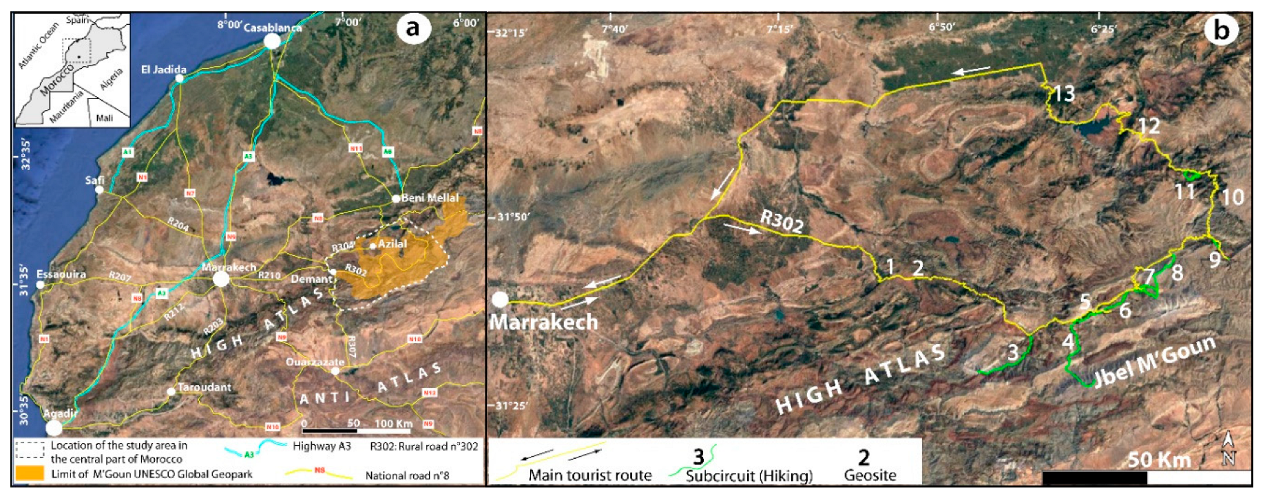
Figure 2.
An example of an interactive map that was created using code developed with the R software.
Figure 2.
An example of an interactive map that was created using code developed with the R software.
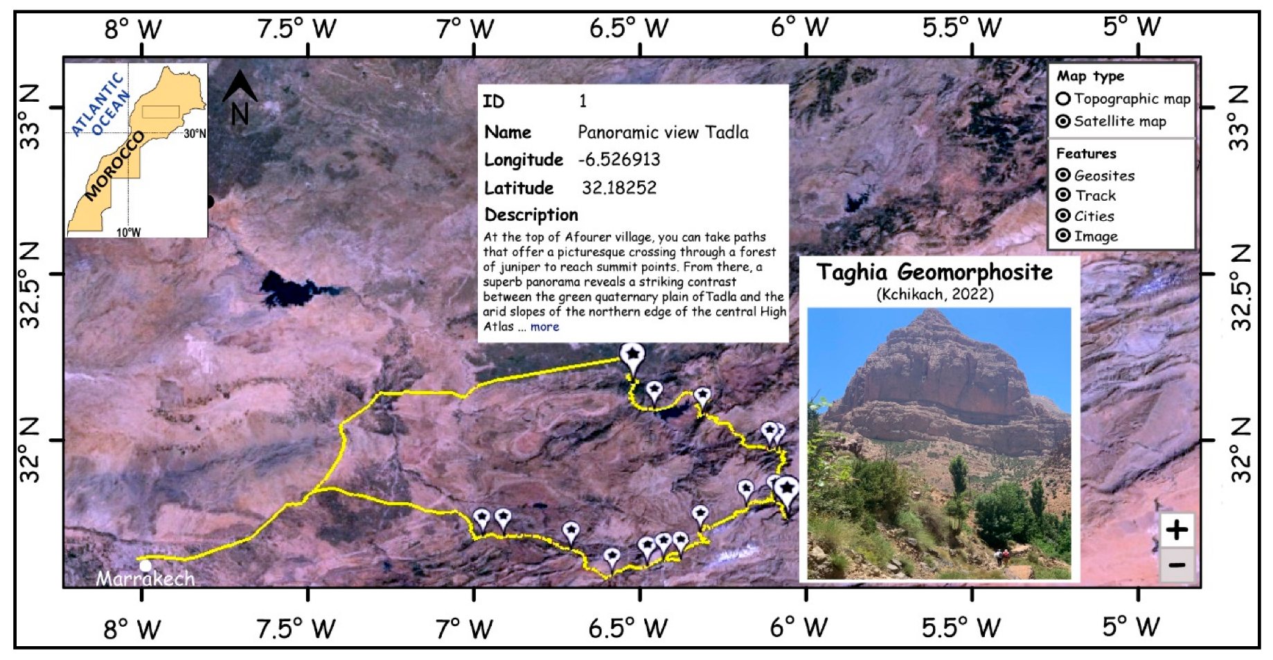
Figure 3.
a. Location of Imin-n-Ifri natural bridge, b. North side of geosite showing tunnel dug by river through travertine under R307, c. Schematic geological section (1. Triassic red clay (200 Ma) 2. Lower Jurassic massive limestone and dolomite beds (-190 Ma) 3. Lower Jurassic laminated limestones (-185 Ma) 4. Quaternary travertines (-0.5 Ma), the ages of the geological formations are given in Souhel, 1996 and Boutakiout et al. 2011, d. Dinosaur tracks in the Iwaridan geosite.
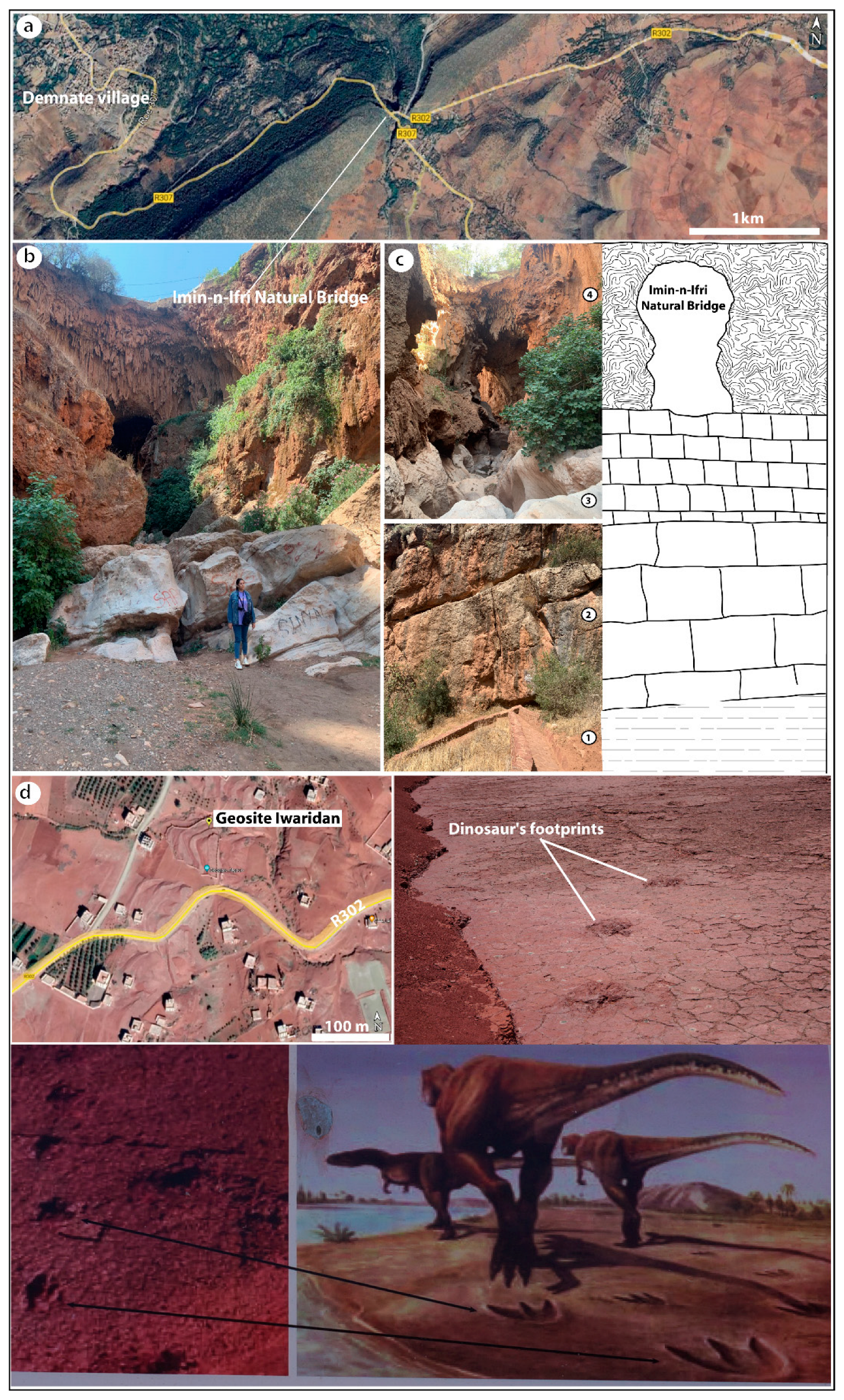
Figure 4.
a. Location of the two main hiking trails in the AitBouguemez valley (Google Earth image), b. Example of a geosite in the valley showing traces of dinosaurs, c. Several sites of rock carvings that also can be visited in the valley.
Figure 4.
a. Location of the two main hiking trails in the AitBouguemez valley (Google Earth image), b. Example of a geosite in the valley showing traces of dinosaurs, c. Several sites of rock carvings that also can be visited in the valley.
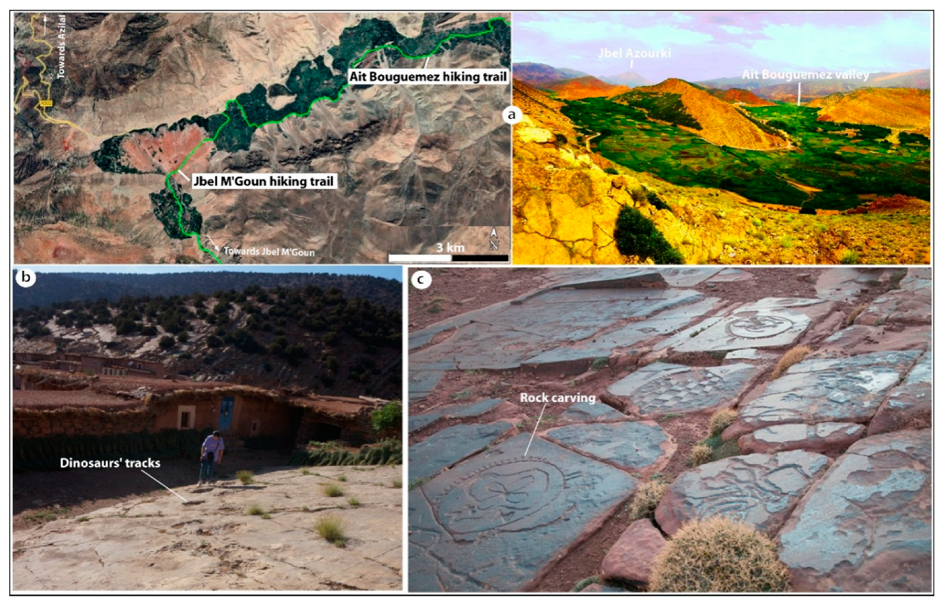
Figure 5.
Location and schematic geological cross section of the Imsfran Cathedral site.
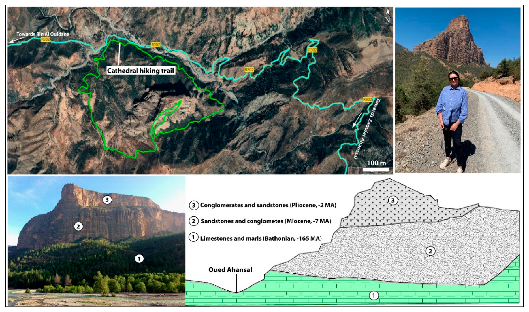
Figure 6.
a.Correlation between the studied variables (the larger the circle diameter, the closer the correlation coefficient to 1), b. Distribution of the total inertia of the collected dataset, c. Representation of individuals and variables in the 1:2 factorial plane (The cos2, which is approximately greater than 0.6, expresses the representativeness of individuals and variables in this plane.).
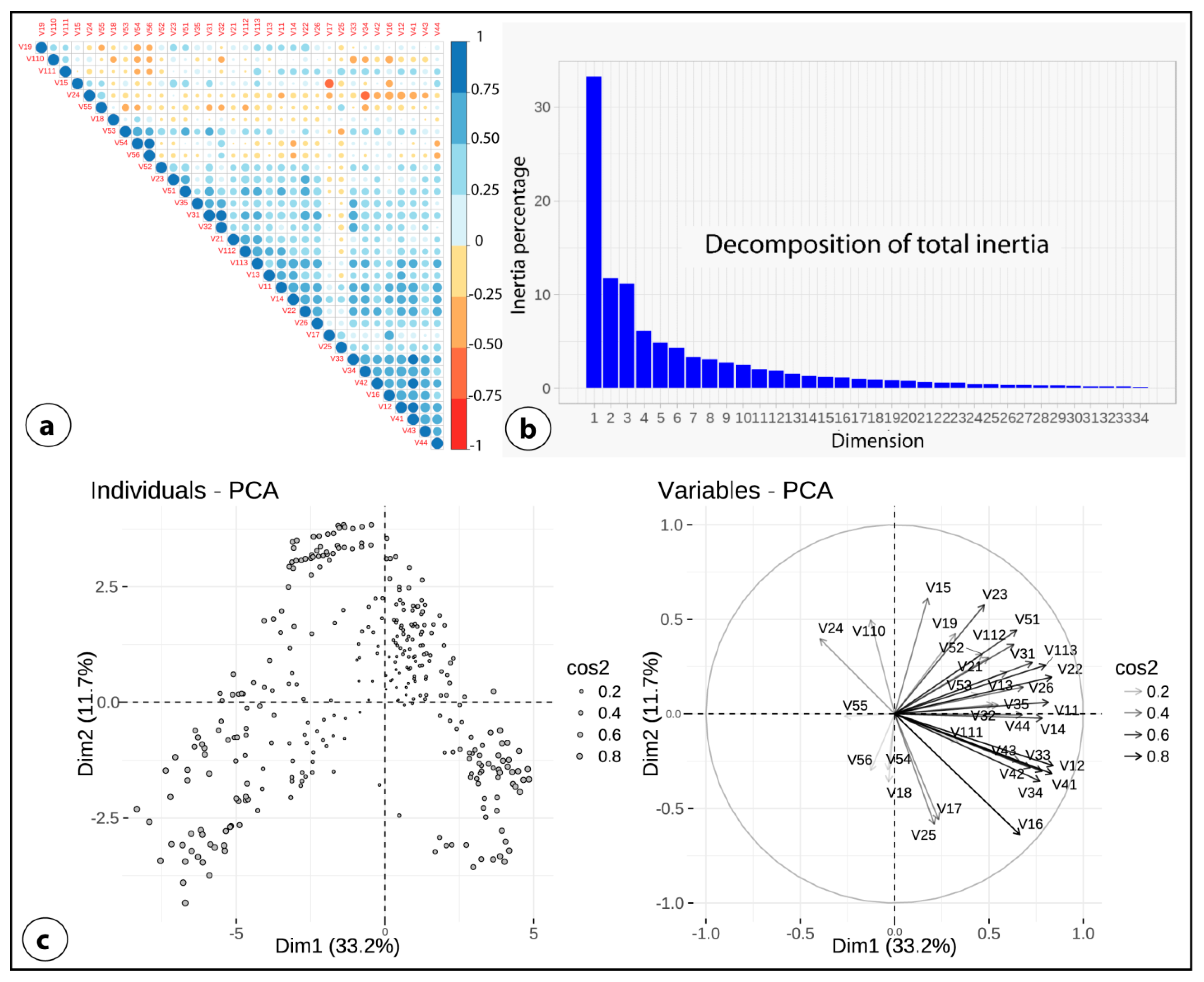
Figure 7.
a. Distribution of each category and corresponding barycenter in the 1:2 factorial plane. b. Visitor groups identified by HCPC analysis. H: Men, F: Woman, O: Yes (from abroad), N: No (from Morocco).
Figure 7.
a. Distribution of each category and corresponding barycenter in the 1:2 factorial plane. b. Visitor groups identified by HCPC analysis. H: Men, F: Woman, O: Yes (from abroad), N: No (from Morocco).
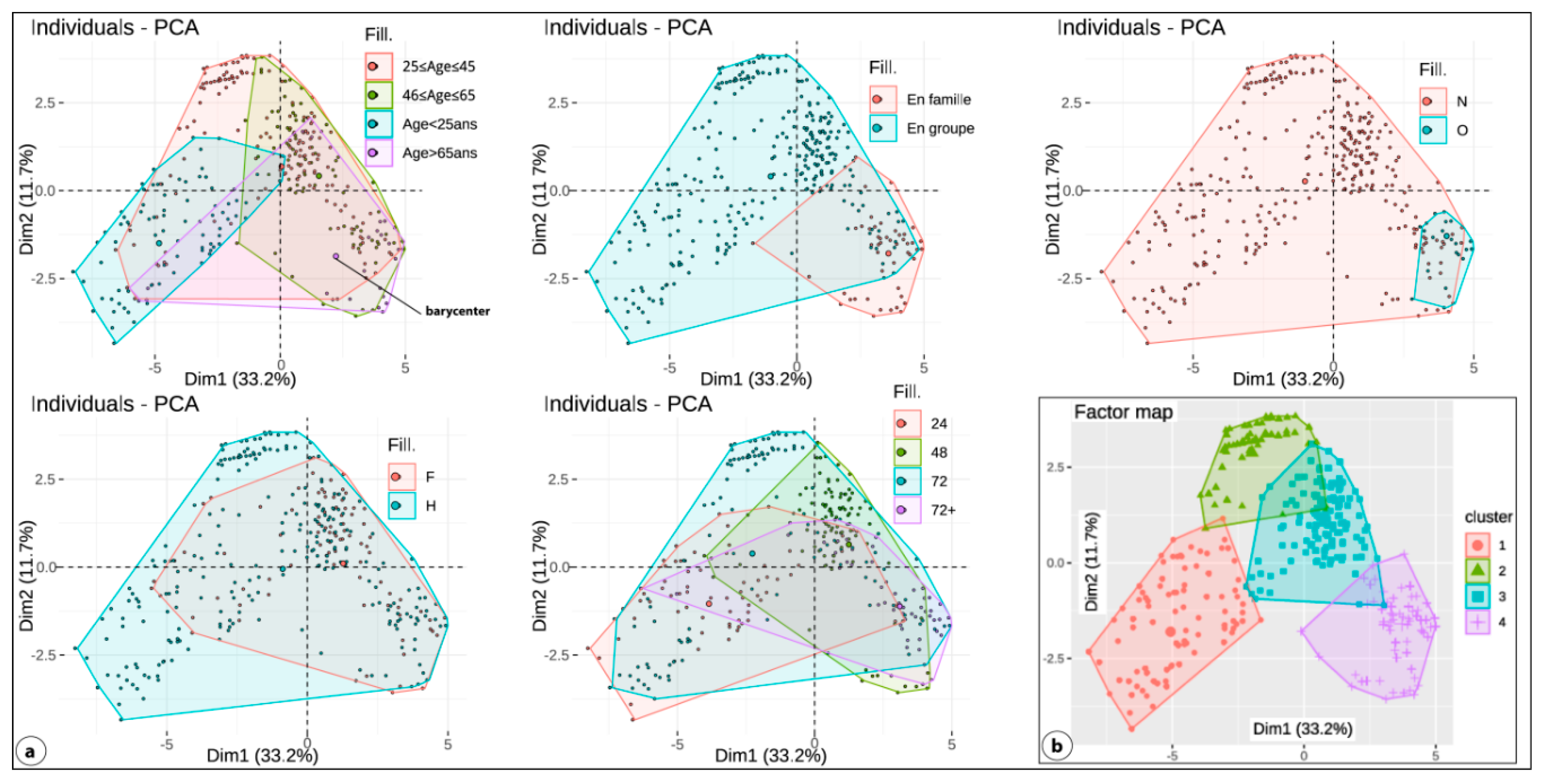

Table 1.
Qualitative modalities and descriptive analysis of the sample (767 individuals) used for the quantitative evaluation of the 34 criteria for the choice of the destination "Central High Atlas in Morocco". H: Men, F: Woman, O: Yes, N: No.
Table 1.
Qualitative modalities and descriptive analysis of the sample (767 individuals) used for the quantitative evaluation of the 34 criteria for the choice of the destination "Central High Atlas in Morocco". H: Men, F: Woman, O: Yes, N: No.
| Gender (H, F) | Number | % | Fromabroad (O, N) | Number | % |
|---|---|---|---|---|---|
| Man | 511 | 66.62 | Morocco | 637 | 83.05 |
| Woman | 256 | 33.38 | Foreign | 130 | 16.95 |
| Age | Number | % | Duration of experience | Number | % |
| Lessthan 25 yearsold | 133 | 17.34 | 24H | 103 | 13.43 |
| Between 25 and 45 yearsold | 349 | 45.50 | 48H | 281 | 36.64 |
| Between 46 and 65 yearsold | 216 | 28.16 | 72H | 236 | 30.76 |
| Over 65 years | 69 | 9.00 | Plus de 72H | 147 | 19.17 |
| Travel type | Number | % | Sites visited among the 13 selected for study | Number | % |
| With the family | 141 | 18.39 | ≤3 | 162 | 21.12 |
| Withfriends | 481 | 62.71 | Entre 4 et 7 | 407 | 53.06 |
| Organized by an agency | 145 | 18.90 | >7 | 198 | 25.82 |
Table 2.
Codes and statistics for the studied factors and variables.
| Factor (Fi) weight, Vexpl. |
Criteria (variable Vij) | Overall rating | Average | Deviation | Internalweight (%) | Overallweight (%) |
|---|---|---|---|---|---|---|
| Territoryattributes (F1) 36.96 % |
Easy access (V11) | 3393 | 4.42 | 0.77 | 8.38 | 3.10 |
| Accommodation capacity (V12) | 2657 | 3.46 | 1.21 | 6.56 | 2.42 | |
| Access to basic services (V13) | 3584 | 4.67 | 0.62 | 8.85 | 3.27 | |
| Feeling safe and secure (V14) | 3524 | 4.59 | 0.62 | 8.70 | 3.22 | |
| Feeling overcoming the difficulty of walking (V15) | 3266 | 4.26 | 1.10 | 8.06 | 2.98 | |
| Easyhikes (V16) | 1932 | 2.52 | 1.60 | 4.77 | 1.76 | |
| Condition of hiking trails (V17) | 2355 | 3.07 | 0.79 | 5.81 | 2.15 | |
| Enjoy walking in unspoilt countryside (V18) | 3670 | 4.78 | 0.41 | 9.06 | 3.35 | |
| Entertainment and leisure activities (V19) | 3312 | 4.32 | 0.81 | 8.18 | 3.02 | |
| Popularity and visibility of the circuit and sub-circuits on social networks (V110) | 3318 | 4.33 | 1.14 | 8.19 | 3.03 | |
| Length of time required to complete the tours (V111) | 2343 | 3.05 | 1.26 | 5.78 | 2.14 | |
| Enjoying contributing to local economic development (V112) | 3649 | 4.76 | 0.52 | 9.01 | 3.33 | |
| Feeling to promote sustainable rural tourism (V113) | 3502 | 4.57 | 0.70 | 8.65 | 3.20 | |
| Value of landscape resources (F2) 19.16 % |
Beautifulnaturallandscapes (V21) | 3761 | 4.90 | 0.26 | 17.91 | 3.43 |
| Contrast with the environment (V22) | 2565 | 3.34 | 0.79 | 12.22 | 2.34 | |
| Differentviews (V23) | 3671 | 4.79 | 0.41 | 17.48 | 3.35 | |
| Feeling the majesty of the high peaks (V24) | 3704 | 4.83 | 0.46 | 17.64 | 3.38 | |
| Discoveringvirgin nature (V25) | 3734 | 4.87 | 0.34 | 17.78 | 3.41 | |
| Diversity of geomorphological features (V26) | 3562 | 4.64 | 0.53 | 16.96 | 3.25 | |
| Value of geological resources (F3) 13.92 % |
Geological value (V31) | 3149 | 4.11 | 0.80 | 20.64 | 2.87 |
| Variety of the geological landscape (V32) | 3322 | 4.33 | 0.62 | 21.78 | 3.03 | |
| Regional, national and international representation of the Atlas chain (V33) | 2454 | 3.20 | 1.16 | 16.09 | 2.24 | |
| Degree of preservation of the geological sites (V34) | 2843 | 3.71 | 0.72 | 18.64 | 2.59 | |
| To understand the geological history of the mountains (V35) | 3486 | 4.54 | 0.50 | 22.85 | 3.18 | |
| Value of ecological resources (F4) 9.85 % |
Biological value (V41) | 2995 | 3.90 | 0.78 | 27.75 | 2.73 |
| Biodiversity (V42) | 2512 | 3.28 | 0.51 | 23.28 | 2.29 | |
| Typical ecosystem (V43) | 2540 | 3.31 | 0.46 | 23.54 | 2.32 | |
| Degree of biodiversity conservation (V44) | 2745 | 3.58 | 0.49 | 25.44 | 2.50 | |
| Value of culture resources (F5) 20.11 % |
Rich and distinctive cultural heritage of the region (V51) | 3684 | 4.80 | 0.40 | 16.71 | 3.36 |
| Hospitality (V52) | 3768 | 4.91 | 0.28 | 17.09 | 3.44 | |
| Discovering local customs and traditions (V53) | 3573 | 4.66 | 0.48 | 16.21 | 3.26 | |
| Discovering local gastronomy and organic food (V54) | 3668 | 4.78 | 0.41 | 16.64 | 3.35 | |
| Celebrating with the local residents (V55) | 3647 | 4.75 | 0.43 | 16.54 | 3.33 | |
| Feeling the value of living simple (V56) | 3704 | 4.83 | 0.38 | 16.80 | 3.38 |
Disclaimer/Publisher’s Note: The statements, opinions and data contained in all publications are solely those of the individual author(s) and contributor(s) and not of MDPI and/or the editor(s). MDPI and/or the editor(s) disclaim responsibility for any injury to people or property resulting from any ideas, methods, instructions or products referred to in the content. |
© 2024 by the authors. Licensee MDPI, Basel, Switzerland. This article is an open access article distributed under the terms and conditions of the Creative Commons Attribution (CC BY) license (http://creativecommons.org/licenses/by/4.0/).
Copyright: This open access article is published under a Creative Commons CC BY 4.0 license, which permit the free download, distribution, and reuse, provided that the author and preprint are cited in any reuse.


