Submitted:
20 February 2024
Posted:
22 February 2024
You are already at the latest version
Abstract
A regional modern river-sand geochemical mapping study in the majority of the Timor-Leste territory, including the research area, has not been previously reported. This study demonstrated the potential of modern river sand geochemical mapping as an effective method for lithological mapping, particularly in areas that face challenges in conducting efficient geological fieldwork and have limited geological information. A total of 53 modern river sand samples were collected and analyzed. Before examining the samples using wavelength-dispersive X-ray fluorescence for ten major elements, the loss-on-ignition method was employed. In the Clerec drainage basin, SiO2, CaO, and K2O showed positive correlations, and CaO was positively correlated with MnO. Similarly, in the Sahe River catchment, a positive relationship was observed between CaO, MnO, and TiO2. These findings suggested the presence of quartz, manganese, secondary K-bearing minerals, and secondary Ti-bearing minerals in carbonate rocks that have undergone silicification and other alteration processes. The principal component analysis results corroborated the SiO2/Al2O3 and K2O/Na2O ratios and the ICV findings. PC1 was related to the variations in Ca-poor and Ca-rich rocks; PC2 indicated notable inputs from SiO2-rich and SiO2-poor rocks; and PC3 revealed the possibility of contributions from secondary mineral assemblages related to silicification and low-grade metamorphic processes.
Keywords:
geochemical mapping
; lithological mapping
; river sands
; principal component analysis
; provenance
; alteration
; silicification
; low-grade metamorphism
; secondary mineral assemblage.
1. Background and the Purpose of Research
Timor-Leste is a relatively new independent country. It officially gained its independence in 2002. Timor-Leste is located between Southeast Asia and the Pacific region, surrounded by Indonesia’s islands, with the western part of the island of Timor shared with Indonesian territory and Australia as its southern neighbor across the Timor Sea (Figure 1A).
Since Portuguese colonization, the geology of Timor-Leste has been studied and mapped. The majority of geological research studies conducted in the territory of Timor-Leste have been concerned with prospecting and discovering oil and natural gas, paleontology, tectonic settings, and stratigraphy [1,2,3,4,5,6,7,8,9,10,11,12,13,14,15,16,17,18,19,20,21,22,23,24,25,26]. However, geochemical mapping studies have not yet been conducted in the majority of the Timor-Leste territory, including the study area.
Timor island is located in a zone where the Australian and the Eurasian plates collide, and it is characterized by active tectonics. This zone has led to the uplifting of land, formation of the landscape, mountain-building processes, installation of overthrust sheets, complex lithological formations, and other geological phenomena and processes within the Timor Island. The terrain of the island is characterized by a rugged topography with steep slopes, large mountains, high peaks, and deep valleys. External geodynamic processes such as erosion and weathering also contribute to landscape shaping. The lithologic formations installed and deposited on Timor Island are largely composed of non-volcanic strata that range in age from Permian to Quaternary. Tectonically, these formations can be classified into allochthonous, para-autochthonous, and autochthonous units, and are similar to the Asian and Australian successions. Some of these formations have been involved in various geological events and tectonic processes, such as deformation, metamorphism, volcanic activity, mineralization, and hydrothermal alterations, before and after the orogenic phase, which occurred from the Late Jurassic to the Middle Miocene [1,2,3,4,8,10,11,18,19,23,25,27,28,29,30,31].
Modern river sands have been used as a sampling medium by numerous researchers in geochemical mapping investigations to determine the relationship between chemical element concentrations and lithological distributions, as well as the location of known or undiscovered mineral deposits [32,33,34,35,36,37,38,39,40,41,42,43].
Most of the land surface of Timor-Leste, including the study area, is covered by light to dense vegetation as well as deformed, weathered, and erosional geological materials. Direct field geological mapping in these regions may also influence lithological identification capability, especially in characterizing more than one type of source or rock unit [44]. This study demonstrated the potential of river sand geochemical mapping as a lithological mapping tool. Starting with the Manufahi municipality and its surroundings, this study must lead to a future national project establishing a geochemical map of the country that can be utilized for environmental studies, mineral resource discovery, and lithological mapping all over the country. This study aimed to establish a geochemical database for a limited area of Timor-Leste and to discuss its characteristics and the relationship with the geology of the study area.
2. Geographical and Geological Setting of Timor-Leste and the Study Area
Officially known as Timor-Leste, the eastern portion of Timor encompasses the island of Atauro to the north, the islet of Jaco to the east, and the enclave of Oecusse, which is bordered by Indonesian West Timor, to the west (Figure 1A and Figure 1B).
The study area is located in the municipality of Manufahi and its surroundings on the southern coast of Timor-Leste. The Timor Sea forms the southern border, while Manatuto, Aileu, and Ainaro Municipalities form the eastern, northern, and western borders, respectively (Figure 1B). The study area is a region of rugged mountainous topography with varying slopes, from almost flat to very steep, where it is possible to observe the activities of external geodynamic processes, such as erosion and weathering. The highest elevations are found in the eastern and northern parts of the territory; the highest peak is at Cablac Mountain, with a height of up to 2085 m.
Timor Island, the islet of Jaco, and several other islands in the southeastern region of the Indonesian archipelago are part of the Outer Banda Arc System because of their position in a complex tectonic setting, where two major plates, the Australian and Eurasian plates, collide. Timor Island is characterized by tectonic and geological features, including the predominance of Permian to Cretaceous sedimentary rocks with affinities to Australian and Asian geological sequences that have undergone significant deformation, resulting in complex structures, faulting, and folding. Conversely, Atauro Island, located in the Banda Sea between Timor and Wetar, is linked to the Inner Banda Arc, an area of geological interest due to its volcanic and tectonic characteristics, which are associated with subduction-related processes ([9,13,14,17,45,46,47,48,49,50,51,52,53,54,55,56,57,58,59,60,61]).
Haig et al. (2007 and 2008), and Keep and Haig (2009) have described the five tectonostratigraphic units of Timor Island that are summarized as follows: (1) the Gondwana Megasequence is largely composed of allochthonous and para-autochthonous sedimentary rocks from pre-rift sequences that were deposited on the northeastern shelf of the Gondwana continent, and its age ranges from the Permian to the Middle Jurassic; (2) the Australian-Margin Megasequence is mostly composed of para-autochthonous sedimentary rocks of the marine environment from post-rift sequences that were deposited on the plateau near the Australian mainland. Its age ranges from the Middle Jurassic to the Middle Miocene, and the initiation of the post-rift sequence deposition at 155 Ma is associated with a significant tectonic event, which is indicated by a break-up unconformity; (3) the Banda Terrane units are characterized by Cenozoic igneous rocks and their cover sediments as well as Mesozoic metamorphic basements that are exposed as thrust sheets and emplaced onto Timor-Leste during the collision phase. They are believed to be derived from the Banda Arc and its forearc arc, as well as components of the crustal blocks of Australia; (4) the Synorogenic Mélange is primarily composed of a matrix rich in scaly clay that is derived from mudrock-rich pre- and post-rift successions. Tectonic processes have transported and reassembled this sequence into a chaotic mixture; and (5) the Synorogenic Megasequence is characterized by autochthonous sedimentary successions installed through uplifting processes and deposited from eroded sediments of existing rocks in the surrounding basin and depressions during the latest Miocene to the Holocene.
The five tectonostratigraphic units are well-preserved from north to south in the study area (Figure 1C and Figure 2), and the contact between these units is a fault and/or unconformity [1,2,3,15,16,19,20,25,29,45,47,52,62,63]. In the northern to central parts of the study area, the Banda Terrane and its sedimentary cover units were emplaced above the Synorogenic Mélange and Gondwana Megasequences. In the southern part, Synorogenic Megasequences were deposited above the Australian-Margin Megasequences during the latest Miocene to Holocene.
According to Bachri and Situmorang (1994), Partoyo et al. (1995), and the geological research conducted by Audley-Charles (1968) and others [2,3,4,6,7,8,10,11,12,14,15,18,19,20,22,23,25,28,50,52,53,55,59,60,61,64,65,66,67,68,69,70,71,72,73], the study area consists of the following formations (Figure 1C and Figure 2).
- a)
-
Pleistocene–Holocene Suai FormationIt is mostly composed of rudites and arenites, with minor amounts of mud and marls. The particles of the formation were mostly sourced from the Viqueque Formation, Dilor Conglomerate, and Lolotoi Complex. This formation belongs to the Synorogenic Megasequence.
- b)
-
Pleistocene–Holocene Ainaro Formation (Ainaro Gravels)This formation is part of the Synorogenic Megasequence and is primarily composed of matrix-supported conglomerates that are believed to be sediments from an ancient river terrace. Occasionally, calcite lateritic cements fill these sediments, and the irregular surfaces of the river terrace sediments are frequently covered by ferruginous horizons.
- c)
-
Lower Pleistocene–Holocene Baucau Limestone (Baucau Formation)It is predominantly composed of coral reef limestones along with a minor proportion of calcarenites, calcirudites, and conglomerates (submature graywackes). This formation is expected to provide evidence of the uplift of the island. This formation belongs to the Synorogenic Megasequence.
- d)
-
Pliocene Dilor Conglomerate (Dilor Formation)This formation is part of the Synorogenic Megasequence and consists of conglomerates and sandstones with a significant contribution of detritus from the Lolotoi Complex, particularly quartzite.
- e)
-
Upper Miocene–Lower Pliocene Viqueque Formation (Synorogenic Viqueque Megasequence)Lithologically, this formation is separated into lower (described as "more clayey and silty") and upper (characterized as "more silty and sandy") sections. Large amounts of silty marls, marly siltstones, silty claystones, siltstones, and sandstones, along with minor proportions of calcilutites and biocalcarenites are present in the upper section. The lower section is mostly composed of marls, clayey marls, silty marls, claystones, silty claystones, calcilutites, and tuffs, with minor amounts of basal conglomerates and mottled marls. These rocks are mostly formed by foraminifera fossils and skeletal radiolarians as well as rock fragments and mineral particles, which are associated with carbonate, metamorphic, volcanic, and other sedimentary rocks found in the Lolotoi Complex, Maubisse Formation, Aitutu Formation, Wailuli Formation, and Bobonaro Complex. This formation is included in the Synorogenic Megasequence.
- f)
-
Middle Miocene Bobonaro Complex (Bobonaro Formation or Bobonaro Scaly-Clay or Bobonaro Mélange or Synorogenic Mélange)This unit is part of the Synorogenic Mélange and is primarily composed of exotic blocks within a scaly clay matrix. The matrix lithology is similar to that of mudstone of the Wailuli Formation. Exotic blocks of Permian to Cretaceous ages are common and widely distributed, although absent in several areas.
- g)
-
Oligocene–Miocene Cablac Limestone (Cablac Formation)This formation is largely composed of oolitic and peloidal limestones and pelagic carbonates with small amounts of intraformational conglomerates, calcilutites, calcarenites, agglomerates, and tuffaceous rocks. The most common clasts of conglomerates are volcanic rocks, calcilutites containing foraminifera, radiolarian chert, biomicarenites, and detrital minerals, such as quartz and magnetite. Several rocks have been affected by alteration processes such as dolomitization and a few have undergone partial silicification, desilicification, and dedolomitization. This formation belongs to the Banda Terrane unit.
- h)
-
Oligocene Barique FormationThis formation belongs to the Banda Terrane unit and is largely composed of mafic to acidic lavas and tuffs, with minor amounts of serpentinites, volcanic conglomerates, and sandstones. Pillow lava is also observed. Significant alterations are observed in most volcanic rocks. Volcanic rocks are considered to have formed at mid-oceanic ridges and volcanic arcs.
- i)
-
Middle–Upper Eocene Dartollu Limestone (Dartolu Formation)This limestone is part of the Banda Terrane unit and its primary constituents are algal and alveolina biomicarenites with minor proportions of calcilutites, siliceous shales, and siltstones. Dolomitization or silicification was not observed.
- j)
-
Lower–Upper Cretaceous Waibua FormationThis formation is part of the Australian-Margin Megasequence and is largely composed of radiolarites, radiolarian cherts, marls, and shales, with several percentages of calcilutites, marls, and calcarenites. Radiolaria and pelagic foraminifera are important components of these rocks and most limestones are completely or partially silicified. Radiolarian shales, marls, and radiolarites often occur in association with Mn nodules and ferromanganiferous rocks. The formation processes of radiolarites and cherts are closely associated with Mn-rich strata.
- k)
-
Late Triassic–Middle Jurassic Wailuli FormationThis formation predominantly consists of gray shales and blue-gray marls with minor amounts of sandstones, mudstones, quartz-arenites, coarse polymictic conglomerates, calcarenites, and calcilutites. Most shales are composed of fine micaceous minerals and microcrystalline carbonates. In some areas, small amounts of pyrite are present in the shales, whereas salt pseudomorphs and gypsum are present in gypsiferous shales, calcilutites, calcarenites, and quartz-arenites. Quartz-arenites contain considerable amounts of mica, and radiolarian and foraminiferal tests are the primary constituents of the calcilutites. This formation is a part of the Gondwana Megasequence.
- l)
-
Middle–Upper Triassic Aitutu FormationThis formation consists mostly of calcilutites, shales, and calcareous shales with minor amounts of marls, calcarenites, lumachelles, quartz-arenites, radiolarites, bituminous rocks, and chert. Some calcilutites include radiolarian fragments and the basal part of this formation consists of conglomerates. Radiolarian fossils are significant components of limestones but are partly or almost entirely filled with sparry calcite. Several limestones have been affected by alteration processes such as silicification, dedolomitization, and pyritization. This formation belongs to the Gondwana Megasequence.
- m)
-
Triassic–Late Cretaceous Lolotoi Complex (Lolotoi Formation or Lolotoi Metamorphic Complex)Belonging to the Banda Terrane units, this complex is composed of regionally metamorphosed sedimentary and volcanic rocks, as well as basic and ultrabasic volcanic rocks. These include greenschists, graphitic phyllites, quartz mica schists, amphibolite gneisses and schists, garnet-bearing pelitic gneisses and schists, metagabbros, granulites, garnet mica schists, mafic and felsic igneous, pelitic schists, metabasite schists, carbonate-rich greenschists, peridotites, blueschists, serpentinites, and pyroxenites. The metamorphic rocks of the Lolotoi Complex mostly originate from sedimentary rocks and some metavolcanic rocks have undergone considerable alteration. The forearc region is thought to have been the location of the deposition of sedimentary rocks, and the rock components are thought to have originated from intermediate to mafic continental and oceanic arcs. Volcanic rocks were formed at volcanic arcs and mid-oceanic ridges.
- n)
-
Permian–Triassic Maubisse Formation (Maubisse Limestone)This formation belongs to the Gondwana Megasequence and is mainly composed of fossiliferous limestones and volcanic rocks, as well as other types of sedimentary rocks. These include well-bedded dense biocalcarenites, massive reef limestones, pink crinoidal limestones, calcirudites, sandstones, calcareous shales, micaceous siltstones, tuffs, volcanic conglomerates, basalts, marbles, and metamorphosed basic volcanics. The basalts are pillowed and amygdaloidal and have an alkaline chemical composition. Alteration processes have affected most rocks of the Maubisse Formation, and limestones have been partially affected by alteration processes such as silicification, dolomitization, and chloritization.
3. Sampling and Analytical Methods
3.1. Sampling Method
The sampling methods and sample preparation techniques used in this study were those described by [42,74,75,76,77,78]. A total of 53 modern river sand samples were collected during the dry season from ten permanent rivers or catchment areas (i.e., the Aiasa, Turon, Ermeti, Holarua, Karau Ulun, Soin, Merek, Laclo do Sul, Clerec, and Sahe Rivers) (Figure 1C and Figure 2). Coordinates and other field-related information, such as geology, geomorphology, and land use, were documented at each sampling point. To avoid sampling errors and heterogeneity of the analytical results, approximately 4 kg of four subsamples were collected over a distance of 20 m at each sampling point. Access conditions, topographic relief, and availability time influenced the sampling point distribution (Figure 3).
River sand samples were transported to the laboratory under wet conditions for preparation and chemical analysis. To obtain grain-size fractions of 180–150 m and <150 m, the samples were dried in an oven at 105 °C and then sieved using a vibrating sieve shaker machine. Manual crushing using an agate mortar and pestle was followed by machine crushing using a disk mill. Subsequently, the organic matter and volatile substances were removed using the loss-on-ignition method, which was verified by weighing the weight loss after heating at 950 °C.
3.2. Analytical Method
According to Yamamoto and Morishita (1997) [79], glass beads are commonly used for sample preparation in XRF spectrometry analysis. Typically, glass beads are prepared by mixing a flux with a powdered sample.
Glass beads were prepared by fusing mixtures of powdered samples and alkali flux at a weight ratio of 1:10. An 8:2 mixture of lithium tetraborate () and lithium metaborate () was used as the alkali flux. The mixture was processed to prepare glass beads using a bead sampler machine (TK-4100 model, Amena Tech Co.) after placing the mixed powder in a platinum crucible. At the Division of Instrumental Analysis, Gifu University, modern river sand samples were examined by wavelength-dispersive X-ray fluorescence using a Bruker S8 Tiger with rhodium target X-ray tubes. Ten major elements (, , , , , , , , , and ) were determined and reference samples of igneous and sedimentary rocks provided by the Geological Survey of Japan were used for calibration.
3.3. Statistical Analysis
The major element compositions to be statistically analyzed and discussed were normalized based on the estimated average concentration of elements in the Upper Continental Crust (UCC) [80] and Post-Archean Australian Shale (PAAS) [81] (Table 1, Figure 4).
To simplify and evaluate the results of the geochemical analysis by reducing the dimensionality of the datasets, exploring elemental associations, and allowing the interpretation of variance within the dataset based on major controlling factors, a multivariate statistical technique, principal component analysis (PCA), was used. To analyze and interpret PCA results in a biplot of joint graphical representations of variables and samples, only principal components with eigenvalues greater than or near 1.0 were used because they explain the majority of the variance in the data [82,83].
In this study, several ratios of selected major elements, the Pearson correlation coefficient matrix, and the index of compositional variability (ICV) were used to analyze and interpret provenance [32,35,40,84,85,86,87,88,89].
The ICV was calculated as weight percent (wt%) proportions (ICV = ) [90]. To avoid mistakes in the analysis and interpretation of ICV values due to carbonate materials, which are abundant in the majority of sediments and sedimentary rocks [91], as well as the carbonate rocks that contribute to the CaO enrichment in river sand samples, the CaO* value represents Ca, which is only present in silicate minerals. According to the concept that the molecular / ratio of silicate is not greater than one, the CaO* value is considered to be equivalent to the content [22,92].
Chemical and statistical analyses were performed using Microsoft Office Excel and JMP Pro 14.0. A geographical map was created using ArcGIS 10.4.
4. Analytical Results
4.1. Geochemical Features of River Sand Samples
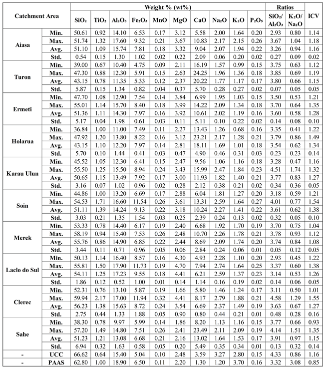
Chemical analyses of river sand samples from the ten drainage basins in the study area revealed that the major oxides with the highest concentrations in the samples were (ranging from 36.84 to 59.94 wt%), (ranging from 4.93 to 24.25 wt%), and (ranging from 9.97 to 17.90 wt%). Meanwhile, , , , , , , and contents ranged from 0.67 to 2.17, 4.75 to 11.94, 0.09 to 0.32, 1.66 to 4.70, 1.06 to 2.79, 0.68 to 2.15, and 0.15 to 0.27 wt%, respectively.
The evaluation results on the statistical summary (Table 1) and spatial distributions of major element concentration values in the study area (Figure 2) indicated that the drainage basins occupied by the Wailuli Formation were rich in (55.81–59.94 wt%), (1.60–2.17 wt%), (16.60–17.90 wt%), (11.54–11.94 wt%), (0.25–0.32 wt%), (2.48–2.74 wt%), (1.88–2.09 wt%), and (0.25–0.27 wt%). These areas also mostly exhibited low concentrations (ranging from 4.93 to 8.20 wt%).
The drainage basins occupied by the Viqueque Formation also had high concentrations of , , , , and , whereas the basins covered by the Dilor Conglomerate were abundant in , , , and . The highest concentrations of were recorded near the midstream areas of the Sahe and Turon River catchments, which were covered by the Aitutu and Viqueque Formations, whereas the other major elements mostly showed the lowest measured contents. In the midstream area of the Holarua River catchment (SS04, near the contact between the Lolotoi Complex, Wailuli Formation, and Ainaro Formation), abundant concentrations of and the lowest reported contents of all other major elements were also observed.
The areas near the midstream of the Laclo do Sul River Basin, specifically those occupied by the Bobonaro Complex, where the highest values were identified, also showed higher concentrations of , , , and . High concentrations of , , , , , and were also found in nearby areas of the Aiasa River catchment upstream, Karau Ulun River catchment downstream, and Ermeti River catchment, particularly those occupied by the Ainaro Formation. In addition, the downstream areas of the Karau Ulun, Laclo do Sul, Clerec, and Sahe River catchments, which were occupied by the Suai Formation, were also abundant in , , , , , and .
4.2. Comparison with UCC and PAAS
The results of the UCC- and PAAS-normalized patterns for the major elements of the river sand samples from the study area are shown in Figure 4. The bulk composition of the UCC is granodioritic and representative of the continental crust [80]. In contrast, PAAS represents a crustal shale sedimentary rock bulk composition [81].
In comparison with the average major element compositions of the UCC and PAAS (Figure 4A and Figure 4B), the composition of the river sand samples from the ten drainage basins revealed a significant depletion in , a slight depletion in , a slight depletion to considerable enrichment in , a slight enrichment in , slight to considerable enrichments in , , and , and considerable to significant enrichments in . However, Turon and Holarua had more abundance and Laclo do Sul and Clerec had lower abundance than in the other river catchments. The UCC-normalized patterns (Figure 4A) showed considerable depletion of , and the concentration of was enriched in the Aiasa, Laclo do Sul, and Clerec drainage basins and depleted in the other river catchments. In contrast, compared to the average composition of the PAAS (Figure 4B), was enriched and was depleted.
The abundance of , depletion of , and variations in concentrations were mostly controlled by the destruction of carbonate, clay and plagioclase minerals, which contributed to the river sand sample compositions from the study area. The enrichment of , , , , and could be related to the contribution of mafic, heavy, and accessory minerals (such as amphibole, pyroxene, biotite, ilmenite, hematite, sphene, rutile, garnet, and other minerals) as well as manganese and phosphate minerals. The depletion of and concentrations also supports the findings that the majority of the rocks in the study area were calcareous cover sediments at the northern edge of the Australian continental shelf. Sedimentary and metamorphic rocks rich in mafic components were also present.
4.3. Geochemical Characteristics of Some Drainage Basins
The results of the Pearson correlation coefficient matrix for the major element compositions of river sand samples from the selected catchment areas (Table 2A-D) and the spatial distribution of major element contents in the study area (Figure 2) are as follows:
- 1)
-
Soin River catchmentAs shown in Table 2A, showed a positive correlation with , , , and , as opposed to , which was negatively associated with and and positively correlated with all other major elements. had a strong positive association with and a negative relationship with all other elements. Positive relationships were observed between , , , , , and . These findings suggest that silicate, heavy, and accessory minerals (such as quartz, plagioclases, amphiboles, ilmenites, rutiles, garnets, apatites, sphenes, muscovites, and chlorites) as well as calcium carbonate, manganese, mica, and clay minerals contributed to the composition of river sand samples in this river catchment.The highest observed amounts of , , , , , , , and , along with the lowest measured concentrations of and , were mostly recorded near the upstream areas. The midstream regions had the lowest observed content and the highest measured concentrations of , , and . In addition, the downstream regions had the highest content, high concentrations of and , and low concentrations of , , , , and . This indicated that the upstream areas were mostly influenced by clay and mica content as well as quartz, plagioclase, amphibole, chlorite, hematite, ilmenite, rutile, garnet, sphene, and apatite minerals, which are associated with siliciclastic sedimentary and metamorphic rocks. Carbonate components and Mn minerals affiliated with calcareous sedimentary rocks, along with the clay content associated with shales and mudstones, made major contributions to the midstream regions. The downstream regions were mostly controlled by silicate minerals, such as quartz associated with siliceous sedimentary rocks, carbonate components, and manganese minerals affiliated with carbonaceous sedimentary rocks, along with clay content related to shales and mudstones.
- 2)
-
Laclo do Sul River catchmentAs shown in Table 2B, was positively correlated with , , , and . was positively associated with , , , , , and . Moderate-to-very strong correlations were observed between , , , , and . These results suggested the major contributions of clay and mica minerals, along with silicate, heavy, and accessory minerals (such as quartz, plagioclase, feldspar, amphibole, pyroxene, biotite, ilmenite, hematite, sphene, rutile, and garnet), which significantly contributed to the geochemical composition of the river sand samples from this river catchment.The concentration appeared to increase in the upstream direction. High , , , , , , , and contents and low and concentrations were recorded near the upstream areas. Downstream and midstream regions, specifically sample location SS045, had high concentrations of , , , and and low and contents. In addition, high values of , , and , along with low concentrations of , , and , were also observed in the downstream area. The destruction of clay and mica, along with quartz, plagioclase, amphibole, chlorite, hematite, ilmenite, rutile, garnet, sphene, and apatite minerals associated with siliciclastic sedimentary and metamorphic rocks, contributed significantly to the composition of the river sands near the upstream regions. Near the downstream and continuing to the midstream regions, quartz and clay contents affiliated with shales and mudstones made major contributions; however, there were significant inputs from mafic and heavy minerals associated with igneous and metamorphic rocks at sample location SS045. Silicate minerals and clay related to sedimentary rocks contributed significantly to the downstream area.
- 3)
-
Clerec River catchmentAs demonstrated by the Pearson correlation of the Clerec River catchment (Table 2C), showed a positive association with and , had a positive correlation with , , , , and , and showed a positive correlation with , , and . There was a moderate-to-very strong positive relationship between , , , , and , indicating that the destruction of clay, mica, amphibole, pyroxene, biotite, ilmenite, hematite, sphene, rutile, garnet, and apatite, along with calcium carbonate, manganese, and alteration minerals, contributed significantly to the composition of the river sand from this river catchment. The positive correlations between , , and indicated that they may have been derived from the same source. The elevated level may be related to the presence of secondary K-bearing minerals.The content tended to increase downstream; however, the highest measured concentration in this river catchment was recorded at the sample site SS049. In the midstream regions, high contents of , , and and the lowest concentrations of and were recorded. The reported distribution of the elemental concentrations near the downstream regions showed high measured values of , , , , , and . In contrast, elevated values of , , and were recorded at sample site SS049. The downstream regions also appeared to have high concentrations of , , and and low and contents. These findings suggest that the midstream areas were largely influenced by quartz, clay, and mica contents as well as lithic fragments, which are associated with siliciclastic sedimentary rocks. Near the downstream regions, clay, muscovite, quartz, plagioclase, chlorite, sphene, garnet and apatite minerals affiliated with siliciclastic sedimentary rocks and their altered rocks owing to metamorphic processes made major contributions. However, sample location SS049 was characterized by notable inputs from quartz, calcium carbonate, manganese, and secondary K-bearing minerals, which were associated with altered carbonate rocks intercalated with shales due to silicification processes. In addition, there were major contributions from silicate and clay contents related to sedimentary rocks in the downstream areas.
- 4)
-
Sahe River catchmenthad a positive correlation with and and showed a very strong association with and they had a moderate-to-strong positive relationship with , , and (Table 2D). Positive associations were observed between , , , , , and . These findings indicated that there were inputs of calcium carbonate, clay, muscovite, manganese, quartz, plagioclase, feldspar, amphibole, biotite, chlorite, ilmenite, hematite, rutile, garnet, sphene, and apatite. The presence of in carbonate rocks associated with Mn minerals is not common. could be associated with Mn minerals in carbonate rocks, suggesting the presence of secondary Ti-bearing minerals owing to certain alteration processes.In this river catchment, the highest concentrations of and appeared in areas near the upstream regions, along with the lowest concentrations of , , , , and . Although high measured concentrations of , , and were reported in the midstream regions, sample location SS015 also appeared to have high measured contents of and and low concentrations of , , , and . The downstream regions were also reported to have high , , , , and contents. This indicate that the composition of the river sand sample near the upstream area and sample location SS013 was mostly controlled by the destruction of quartz, clay, and mica minerals, which were affiliated with siliciclastic sedimentary rocks; however, silicate and accessory minerals (such as quartz, muscovite and garnet minerals), which are associated with their altered rocks due to metamorphic processes, contributed to the sample location SS013. Sample sites SS014 and SS015 had contributions from calcium-carbonate minerals associated with carbonate rocks; however, there were notable inputs from quartz and secondary K-bearing minerals affiliated with altered carbonate rocks intercalated with shales strata due to silicification processes in the sample location SS014, and considerable contributions to SS015 came from calcium carbonate, manganese, and Ti-bearing minerals, which were also associated with altered carbonate rocks intercalated with shales strata due to certain alteration processes. The downstream regions were characterized by contributions from quartz, clay, carbonate, mica, amphibole, chlorite, ilmenite, garnet, and other minerals related to sedimentary rocks.
5. Discussion
5.1. Relationship between River Sand Geochemistry and Provenance Geology
The / and / ratios, as well as the geochemical index of ICV, are also frequently used to evaluate the abundance of quartz, clay, K-feldspar, plagioclase, and other less resistant minerals to identify provenance [32,35,40,84,85,86,87,88,89,90,93,94,95]. The / ratio has different average values for determining source rock compositions and sediment maturities in clastic sediments; in basic igneous rocks, the ratio is approximately 3 and the ratio is approximately 5 in acidic igneous rocks. Hereafter, in clastic sediments, values >5 indicate compositionally mature sediments and values >10 indicate high maturity and potential recycling [86,88,89,95,96].
In the study area, the values of / ratios ranged from 2.93 to 4.58, with an average of 3.59, slightly higher than PAAS but slightly lower than UCC (Table 1), suggesting that river sand compositions were not as silica and aluminum-rich as the average composition of typical crustal shale and granodiorite. Most of the selected drainage basins showed negative associations between the / ratios and elements such as , , , , and (Table 2A-D), suggesting that these elements were not highly associated with silicate minerals but were incorporated into clay minerals. These results indicated that the river sand composition in the study area was largely derived from crustal carbonate sources. In the study area, the major contributions of carbonate components were mostly attributed to the presence of calcareous sedimentary rocks, such as calcilutites, calcareous shales, and marls. These rocks are mainly associated with the Aitutu, Wailuli, and Viqueque Formations.
The / ratio also has variational values in defining the abundance of K-feldspar relative to plagioclase; with high values (> 1) suggesting potential contributions from alkali feldspar or mica and/or possibly from secondary K-bearing minerals, whereas for the abundance of sodium-bearing minerals or plagioclase, the ratios were < 1 [84,87,88,89].
The / ratios in the study area ranged from 0.41 to 1.74, with an average of 0.73, which was much lower than those of UCC and PAAS (Table 1). Compared with the UCC, the and concentrations showed greater depletion, which could be related to the low contribution of feldspathic minerals [88,97,98]. These results indicated that the river sand content in the study area was also characterized by an abundance of aluminosilicate compared to feldspar. The highest values of the / ratio (>1) were identified at several sampling points (Figure 5), which were mostly characterized by notable inputs from aluminosilicate and accessory minerals such as clays and muscovites. These minerals were mainly sourced from claystones, siltstones, sandstones, mica schist, and other metamorphic rocks rich in accessory minerals, such as muscovites, as well as shales, micaceous shales, micaceous sandstones, and their altered forms owing to metamorphic processes, which were affiliated with the Viqueque Formation, Dilor Conglomerate, and Wailuli Formation, respectively. However, sample locations SS049, SS014, and SS015 revealed features indicative of the presence of secondary K-bearing minerals associated with altered carbonate rocks intercalated with shales, as a result of silicification and certain alteration processes. These altered rocks are associated with the Aitutu and Wailuli Formations.
Cox et al. (1995) also determined ICV values greater than 1 for the sediments rich in non-clay minerals (chlorites, feldspars, amphiboles, and pyroxenes), whereas values less than 1 were found for sediments with significant concentrations of clay minerals (kaolinite, illite and montmorillonite) [32,84,86,88,89].
The ICV values in the study area ranged from 0.93 to 1.55, with an average of 1.26, which was much higher than those of PAAS and UCC (Table 1). The high concentrations of , , , , and compared with UCC and PAAS, as well as the positive association between these elements in most drainage basins, corroborate the presence of mafic sources containing heavy and accessory minerals (such as amphibole, pyroxene, biotite, ilmenite, hematite, sphene, rutile, and garnet) [84,99]. These results revealed the abundance of chlorite minerals along with mafic, heavy, and accessory minerals in the river sand. The occurrence of basic igneous and metamorphic rocks is mainly responsible for the contribution of these minerals to the research area. These rocks are affiliated with the Lolotoi Complex; however, they can be integrated into sedimentary rock fragments and matrices associated with the Aitutu, Wailuli, and Viqueque Formations and/or incorporated into mudstones and shales within the Bobonaro Complex as exotic blocks.
5.2. PCA
PCA was conducted on the major elemental compositions of stream sediments from the ten river catchments in the study area to determine their provenance. The first three principal components of the samples and variables with eigenvalues greater than or near 1.0 were processed for analysis and interpretation (Figure 6) [82,83].
The PCA results for the variables and samples are presented in Table 3 and Table 4 and in Figure 7 and Figure 8. The first, second, and third principal components accounted for approximately 49.74%, 20.23%, and 13.61% of the total explanations, respectively.
As shown in Table 3 and Table 4 and Figure 7 and Figure 8, PC1 had a strong negative association with (-0.40), especially for samples SS029 (-6.23), SS015 (-5.05), SS04 (-4.22), SS06 (-4.00), SS030 (-2.84), and SS014 (-2.55). Negative PC1 scores were attributed to the inputs from Ca-rich rocks. As the carbonate minerals were solely composed of , it can be concluded that the carbonate components contributed more to the negative values of PC1. The abundance of carbonate components may be related to the presence of calcilutites, calcareous shales, marls, and conglomerates rich in carbonate rock fragments in the Aitutu, Wailuli, Viqueque, and Ainaro Formations. PC1 had a strong positive correlation with (0.42), (0.37), (0.36), (0.35), and (0.33) for the samples SS023 (3.56), SS050 (3.24), SS040 (3.20), SS041 (3.14), SS042 (3.11), and SS01 (2.81). Ca-poor rocks were correlated with positive PC1 values. These samples were collected from shale-, claystone-, siltstone-, marl-, and mudstone-rich formations, which are associated with the Wailuli, Viqueque, Suai, and Ainaro Formations and the Bobonaro Complex. Clay minerals rich in , , , , and in the shales, claystones, siltstones, marls, and mudstones of these formations were highly positively correlated with PC1.

Table 3.
The first four principal components of the variables with eigenvalues greater than or near 1.0
Table 3.
The first four principal components of the variables with eigenvalues greater than or near 1.0
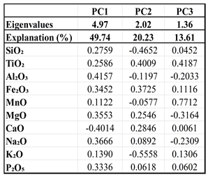 |
PC2 was strongly and positively associated with (0.40), (0.37), (0.28), and (0.25), particularly in the following samples: SS04 (3.64), SS050 (2.64), SS045 (2.35), SS015 (2.06), SS019 (1.60), and SS025 (1.58). Input from -poor rocks may explain the positive values of PC2. The elemental association of the positive values of PC2, possibly related to the contributions from mafic, heavy, and accessory mineral (such as amphiboles, pyroxenes, biotites, ilmenites, hematites, titanites, rutile, garnet, apatite, and others) inputs, is mainly attributed to the occurrence of basic igneous and metamorphic rocks in the study area. These rocks are associated with the Lolotoi Complex, but they may also be integrated into sedimentary rock fragments and matrices associated with the Aitutu, Wailuli, Viqueque, Ainaro, and Suai Formations as well as the Dilor Conglomerate. These rocks may have also been incorporated into mudstones and shales as exotic blocks within the Bobonaro Complex. Component 2 also had strong negative loadings for (-0.56) and (-0.47). Negative PC2 scores were observed for samples SS049 (-3.84), SS012 (-3.65), SS043 (-2.27), SS039 (-2.25), SS014 (-2.06), and SS09 (-1.98). -rich rocks may have been responsible for the negative PC2 scores. The inputs of mica (muscovite) and quartz minerals may have contributed to the higher and concentrations, which consequently influenced the negative values of PC2. In the study area, these minerals are mostly ascribed to the existence of shales, micaceous shales and sandstones, conglomerates, sandstones, siltstones, claystones, mudstones, quartzites, mica schists, and other metamorphic rocks of the Aitutu, Wailuli, Viqueque, and Ainaro Formations, Lolotoi Complex, and Dilor Conglomerate, as well as exotic blocks of these rocks from the Lolotoi Complex, Aitutu Formation, and Wailuli Formation within the Bobonaro Complex.
Table 4.
The first four principal components of the samples with eigenvalues greater than or near 1.0
Table 4.
The first four principal components of the samples with eigenvalues greater than or near 1.0
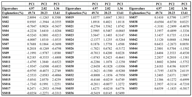 |
The third principal component had a strong positive loading for (0.77), (0.42), (0.13), and (0.11) and was strongly correlated with samples SS049 (2.61), SS050 (2.59), SS015 (2.43), SS013 (2.27), SS021 (1.87), and SS09 (1.86) (Table 3 and Table 4, Figure 8). The elemental association of positive PC3 scores may be associated with contributions from manganese, siderite, pyrite, secondary Ti-bearing minerals and K-bearing minerals. In the study area, these minerals were ascribed to the presence of exotic blocks of garnet mica schists, mica schists, and quartzites within the Bobonaro Complex; sandstones and conglomerates rich in the Lolotoi Complex’s metamorphic rock fragments of the Dilor Conglomerate; and altered siliciclastic sedimentary and carbonate rocks intercalated with shales due to metamorphic, silicification, and other alteration processes of the Wailuli and Aitutu Formations. Component 3 was also strongly associated in negative way with (-0.32), (-0.23), and (-0.20), and negative PC3 values were recorded for samples SS029 (-2.13), SS010 (-1.68), SS047 (-1.58), SS042 (-1.40), SS040 (-1.33), SS044 (-1.15), and SS046 (-1.14) (Table 3 and Table 4, Figure 8). The occurrence of secondary mineral assemblages in low-grade metamorphic conditions, such as chlorite, albite, and epidote, could influence the negative PC3 values by contributing greater amounts of , , and . These river sand samples were collected from shales, marls, sandstones, claystones, siltstones, conglomerates, and mudstone-rich formations affiliated with the Wailuli, Viqueque, Ainaro, and Suai Formations and the Bobonaro Complex.
The findings of the PCA were consistent with the results of the / and / ratios as well as those of the ICV.
6. Conclusion
The results of the bulk geochemical composition analysis of the river sand samples from the study area showed an abundance of and a slight depletion in and concentrations, which were related to the major contributions from the calcareous cover sediments of the northern edge of the Australian continental shelf and from carbonate components that are integrated into sedimentary rocks in different proportions. Most of the catchment areas revealed a positive correlation between the / ratios and most of the major elements, including the abundance of , , , and , and a positive relationship between high contents of , , , , and . The average value of the / ratio was less than 1, and the ICV was greater than 1, suggesting that clay, mica, and chlorite contents along with amphibole, pyroxene, biotite, ilmenite, hematite, sphene, rutile, garnet, and other minerals play a significant role in influencing the composition of the river sand samples. The enrichment of MnO may be explained by a significant contribution from manganese minerals and a lesser but considerable contribution from accessory, heavy, and mafic minerals (such as garnets, ilmenites, and pyroxenes). Calcareous sedimentary rocks such as calcilutites, calcareous shales, marls, and calcarenites are predominantly found in areas occupied by the Aitutu, Wailuli, and Viqueque Formations. Clay, mica, quartz, and other aluminosilicate contents were mainly sourced from shales, micaceous shales, micaceous sandstones, and their altered forms due to metamorphic processes, as well as claystones, siltstones, mudstones, sandstones, conglomerates, and quaternary sediments, which are found in areas covered by the Wailuli, Viqueque, Ainaro, and Suai Formations, as well as the Bobonaro Complex and Dilor Conglomerate. In contrast, mafic sources containing heavy and accessory minerals (such as amphiboles, pyroxenes, biotites, ilmenites, hematites, sphenes, rutiles, and garnets) were related to the presence of basic igneous, metamorphic, conglomerate, shales, and mudstones. These rocks are mostly found in regions encompassed by the Wailuli Formation, Bobonaro Complex, Dilor Conglomerate, and Ainaro Formation as well as near the contact between the Lolotoi Complex and the Wailuli Formation. High concentrations of , , and were also recorded at sampling sites covered by carbonate rocks intercalated with shales of the Wailuli and Aitutu Formations (SS049, SS014, and SS015). In the drainage basins from these sampling locations, a positive correlation was identified between , , and , and was positively associated with ; however, , , and were positively correlated. These results were related to the occurrence of quartz and secondary K-bearing minerals and Ti-bearing minerals associated with calcium carbonate and manganese minerals in carbonate rocks that have undergone silicification and other alteration processes.
These findings were also supported by the PCA results, which showed that the first and second principal components were correlated with the origin and composition of the underlying lithologies and that PC3 could possibly reveal the presence and distribution of alteration minerals related to metamorphism and hydrothermalism. The first principal component was associated with variations in Ca-poor and Ca-rich rocks, with positive scores indicating significant contributions from clay minerals and negative scores indicating a notable input from carbonate components. PC2 may capture the variations associated with compositional differences between the -rich and -poor rocks. Positive PC2 scores suggested notable inputs from amphibole, pyroxene, biotite, ilmenite, rutile, and garnet minerals. Mica (muscovites) and quartz minerals may have contributed significantly to negative PC2 values. PC3 explained the occurrence and distribution of altered minerals related to metamorphism and hydrothermalism. Positive values indicated the possibility of contributions from Mn, siderite, pyrite, secondary Ti-bearing minerals, and secondary K-bearing minerals. The negative PC3 scores could be related to inputs from low-grade metamorphic mineral assemblages, such as chlorite, albite, and epidote.
This study proved that river sand geochemical mapping is a valuable tool for lithological mapping in areas with limited geological information because of limited accessibility and dense vegetation coverage, as well as deformed, weathered, and erosion-covered geological materials.
Author Contributions
Vital Vilanova: Conceptualization, Methodology, Validation, Investigation, Formal Analysis, Writing—original draft. Tomoyuki Ohtani: Validation, Supervision, Visualization, Writing—review and editing. Satoru Kojima: Validation, Supervision, Visualization, Writing—review and editing. Kazuma Yatabe: Formal analysis. Nene Cristovão and Aniceta Araujo: Investigation, Formal Analysis. All authors have read and agreed to the published version of the paper.
Funding
This research and the APC were funded by the Japan International Cooperation Agency (JICA) Development Studies Program, Human Resources Development in Science and Technology Innovation and the Earth Science Laboratory, Faculty of Engineering, Gifu University.
Acknowledgments
This study was financially supported by the Japan International Cooperation Agency (JICA) Development Studies Program and Human Resources Development in Science and Technology Innovation. We are grateful to Professor Nagayoshi Katsuta and Mr. Matsuki of Gifu University for permitting us to use the laboratory to prepare glass bead samples. We also thank the staff of the Ministry of Petroleum and Mineral Resources, particularly the Institute of Petroleum and Geology and the National Petroleum and Minerals Authority, Dili, Timor-Leste, for authorizing the shipment of samples from Timor-Leste to Japan. We express our gratitude to the Nagoya University Museum, JICA, and Faculty of Engineering of the Gifu University staff members, Prof. Dr. Koshi Yamamoto, Prof. Dr. Koichi Shimakawa, Mr. Atsushi Takahashi, Ms. Mieko Araki, Ms. Yukiko Eguchi, and Ms. Midori Iinuma.
Conflicts of Interest
The authors declare that they have no conflicts of financial or non-financial interests that could impact the subject matter or reported research results in this paper.
Abbreviations
The following abbreviations are used in this paper:
| PCA | Principal component analysis |
| PC1 | Principal component 1 |
| PC2 | Principal component 2 |
| PC3 | Principal component 3 |
| ICV | Index of compositional variability |
| XRF | X-ray fluorescence |
| UCC | Upper continental crust |
| PAAS | Post-Archean Australian Shale |
| Mn | Manganese |
| K-bearing minerals | Potassium-bearing minerals |
| Ti-bearing minerals | Titanium-bearing minerals |
| JMP | Jump, statistical analysis software developed by JMP |
| ArcGIS | Aeronautical Reconnaissance Coverage Geographic Information System |
| JICA | Japan International Cooperation Agency |
References
- Audley-Charles, M. G. The Geology of Portuguese Timor. Memoirs of the Geological Society of London 1968, 4, 1–75. [Google Scholar]
- Audley-Charles, M. G. Tectonic Post-Collision Processes in Timor. The Geological Society of London, Special Publication 2011, 355, 241–266. [Google Scholar] [CrossRef]
- Audley-Charles, M. G., Carter, D. J., & Barber, A. J. Stratigraphic Basis for Tectonic Interpretation of the Outer Banda Arc, Eastern Indonesia. Proceeding Indonesian Petroleum Association, Indonesia, Third Annual Convention, June 1974, 25–44.
- Audley-Charles, M. G., & Carter, D. J. Tectonic Post-Collision Processes in Timor. Palaeogeographical Significance of Some Aspect of Palaeogene and Early Neogene Stratigraphy and Tectonics of the Timor Sea Region. 1972, 11, 247–264.
- Bachri, S., & Situmorang, R. L. Peta Geologi Lembar Dili, Timor Timur, Skala 1: 250.000. Pusat Penelitian dan Pengembangan Geologi, 1994.
- Barber, A. J.; Audley-Charles, M. G. The Significance of the Metamorphic Rocks of Timor in the Development of the Banda Arc, Eastern Indonesia. Tectonophysics 1976, 30, 119–128. [Google Scholar] [CrossRef]
- Boger, S. D., Spelbrink, L. G., Lee, R. I., Sandiford, M., Maas, R., & Woodhead, J. D. Isotopic (U-Pb, Nd) and Geochemical Constraints on the Origins of the Aileu and Gondwana Sequences of Timor. Journal of Asian Earth Sciences 2017, 134, 330–351. [CrossRef]
- Charlton, T. R. Stratigraphic Correlation Across an Arc-Continent Collision Zone: Timor and the Australian Northwest Shelf. Australian Journal of Earth Sciences 1989, 36, 263–274. [Google Scholar] [CrossRef]
- Charlton, T. R. Post-Collision Extension in Arc-Continent Collision Zones, Eastern Indonesia. Geology 1991, 19(1), 28–31. [Google Scholar] [CrossRef]
- Charlton, T. R. The Structural Setting and Tectonic Significance of the Lolotoi, Laclubar and Aileu Metamorphic Massifs, East Timor. Journal of Asian Earth Sciences 2002, 20, 851–865. www.elsevier.com/locate/jseaes. [CrossRef]
- Charlton, T. R., Barber, A. J., Harris, R. A., Barkham, S. T., Bird, P. R., Archbold, N. W., Morris, N. J., Nicoll, R. S., Owen, H. G., Owens, R. M., Sorauf, J. E., Taylor, P. D.,Webster, G. D.; Whittaker, J. E. The Permian of Timor: Stratigraphy, Palaeontology and Palaeogeography. Journal of Asian Earth Sciences 2002, 20, 719–774. www.elsevier.com/locate/jseaes.
- Charlton, T. R., Barber, A. J., McGowan, A. J., Nicoll, R. S., Roniewicz, E., Cook, S. E., Barkham, S. T., & Bird, P. R. The Triassic of Timor: Lithostratigraphy, Chronostratigraphy and Palaeogeography. Journal of Asian Earth Sciences 2009, 36(4-5, 341–363. [CrossRef]
- Ely, K. S., Sandiford, M., Hawke, M. L., Phillips, D., Quigley, M., & Reis, J. E. dos. Evolution of Ataúro Island: Temporal constraints on subduction processes beneath the Wetar zone, Banda Arc. Journal of Asian Earth Sciences 2011, 41(6), 477–493. [CrossRef]
- Haig, D. W. Palaeobathymetric Gradients Across Timor During 5.7 - 3.3 Ma (Latest Miocene-Pliocene) and Implications for Collision Uplift. Palaeogeography, Palaeoclimatology, Palaeoecology 2012, 331-332, 50–59. [Google Scholar] [CrossRef]
- Haig, D. W., McCartain, E., Barber, L., Backhouse, J. Triassic - Lower Jurassic Foraminiferal Indices for Bahaman - Type Carbonate - Bank Limestones, Cablac Mountain, East Timor. Journal of Foraminiferal Research, 2007; 37, 248–264. [CrossRef]
- Haig, D. W., McCartain, E. W., Keep, M., Barber, L. Re-evaluation of the Cablac Limestone at Its Type Area, East Timor: Revision of the Miocene Stratigraphy of Timor. Journal of Asian Earth Sciences 2008, 33(5–6), 366–378. [CrossRef]
- Haig, D. W., Mossadegh, Z. K., Parker, J. H., & Keep, M. Middle Eocene neritic limestone in the type locality of the volcanic Barique Formation, Timor-Leste: Microfacies, age and tectonostratigraphic affinities. Journal of Asian Earth Sciences 2019, X, 1. [CrossRef]
- Harris, R. A. Rise and Fall of the Eastern Great Indonesian Arc Recorded by the Assembly, Dispersion and Accretion of the Banda Terrane, Timor. Gondwana Research 2006, 10(3–4), 207–231. [CrossRef]
- Harris, R. A. The Nature of the Banda Arc - Continent Collision in the Timor Region. Arc-Continent Collision, Frontiers in Earth Sciences 2011, 4, 163–211. [Google Scholar] [CrossRef]
- Keep, M., Haig, D. W. Deformation and Exhumation in Timor: Distinct Stages of a Young Orogeny. Tectonophysics 2009, 483(1–2), 93–111. Tectonophysics. [CrossRef]
- Leme, J. C. A. Breve Ensaio Sobre a Geologia da Província de Timor. Junta de Investigações do Ultramar, Geólogo da Missão de Estudos Agronómicos do Ultramar 1968, 1, 106–161. [Google Scholar]
- Lisboa, J. V. V., Silva, T. P., De Oliveira D. P. S, & Carvalho, J. F. Mineralogical and Geochemistry Characteristics of the Bobonaro Melange of Western East Timor: Provenance Implications. Comunicações Geológicas 2020, 106(I), 35–49. https://www.lneg.pt/wp-content/uploads/2020/05/Volume_106.pdf.
- Park, S.-I., Kwon, S., & Kim, S. W. Evidence for the Jurassic Arc Volcanism of the Lolotoi complex, Timor: Tectonic Implications. Journal of Asian Earth Sciences 2014, 95, 254–265. [CrossRef]
- Partoyo, E., Hermanto, B., & Bachri, S. Peta Geologi Lembar Baucau, Timor Timur, Skala 1: 250.000. Pusat Penelitian dan Pengembangan Geologi., 1995.
- Standley, C. E., & Harris, R. Tectonic Evolution of Forearc Nappes of the Active Banda Arc - Continent Collision: Origin, Age, Metamorphic History and Structure of the Lolotoi Complex, East Timor. Tectonophysics 2009, 479(1-2), 66–94. [CrossRef]
- Wittouck, S. F. Exploration of Portuguese Timor. Report of Allied Mining Corporation to Asia Investment Company, Limited 1937.
- Audley-Charles, M. G. The Geology of Portuguese Timor. Doctor Thesis, University of London, London–England, March 1965.
- Barber, A. J., Audley-Charles, M. G., Carter, D. J. Thrust Tectonics in Timor. Journal of the Geological Society of Australia 1977, 24, 51–62. [CrossRef]
- Carter, D. J., Audley-Charles, M. G., & Barber, A. J. Stratigraphical Analysis of Island Arc - Continental Margin Collision in Eastern Indonesia. The Journal of Geological Society of London 1976, 132, 179–198.
- Grady, A. E., Berry, R. F. Some Palaeozoic - Mesozoic Stratigraphic - Structural Relationships in East Timor and Their Significance in the Tectonics of Timor. Journal of the Geological Society of Australia 1977, 24, 203–214. [CrossRef]
- Harris, R.A.; Long, T. The Timor Ophiolite, Indonesia: Model or Myth? Geological Society of America 2000, 349, 321–330. [Google Scholar]
- Bineli, M. T. N., Onana, V. L., Noa Tang, S. D., Bikoy, Y. R., & Ekodeck, G. E. Mineralogy and geochemistry of sands of the lower course of the Sanaga River, Cameroon: implications for weathering, provenance, and tectonic setting. Acta Geochimica 2021, 40(3), 348–365. [CrossRef]
- Brundin, N.H.; Nairis, B. Alternative Sample Types in Regional Geochemical Prospecting. Journal of Geochemical Exploration 1972, 1, 7–46. [Google Scholar] [CrossRef]
- Franzinelli, E.; Potter, P. E. Petrology, Chemistry, and Texture of Modern River Sands, Amazon River System. Journal of Geology 1983, 91, 23–39. [Google Scholar] [CrossRef]
- Liyouck, P. R., Ngueutchoua, G., Armstrong-Altrin, J. S., Sonfack, A. N., Kontchipe Ngagoum, Y. S., Ekoa Bessa, A. Z., Ambassa Bela, V., Tsanga, D. A., & Wouatong, A. S. L. Petrography and geochemistry of the Sanaga river sediments, central Cameroon: Constraints on weathering, provenance, and tectonic setting. Journal of African Earth Sciences, 199, 104840 2023, 199 (104840). [CrossRef]
- Nesbitt, H. W., Young, G. M. Petrogenesis of sediments in the absence of chemical weathering: Effects of abrasion and sorting on bulk composition and mineralogy. Sedimentology 1996, 43, 341–358. [CrossRef]
- Nurmi, P.A.; Isohanni, M. Rock, Till, and Stream Sediment Geochemistry in the Search for Porphyry-Type Mo-Cu-Au Deposit in the Proterozoic Rautio Batholith, Western Finland. Journal of Geochemical Exploration 1984, 20, 209–228. [Google Scholar] [CrossRef]
- Ortiz, E.; Roser, B.P. Geochemistry of Stream Sediments from the Hino River, SW Japan: Source Rock Signatures, Downstream Compositional Variations, and Influence of Sorting and Weathering. Earth Science (Chikyu Kagaku) 2006, 60, 131–146. [Google Scholar]
- Ortiz, E., & Roser, B. P. Major and trace element provenance signatures in stream sediments from the Kando River, San’in district, southwest Japan. Island Arc 2006b, 15(2), 223–238. [CrossRef]
- Rahman, M. A., Das, S. C., Pownceby, M. I., Tardio, J., Alam, M. S., & Zaman, M. N. Geochemistry of Recent Brahmaputra River Sediments: Provenance, Tectonics, Source Area Weathering and Depositional Environment. Minerals 2020, 10(9), 1–30. [CrossRef]
- Ranasinghe, P. N., Fernando, G. W. A. R., Dissanayake, C. B., & Rupasinghe, M. S. Stream Sediment Geochemistry of the Upper Mahaweli River Basin of Sri Lanka-Geological and Environmental Significance. Journal of Geochemical Exploration, 99(1–3), 1–28 2008, 99(1-3), 1–28. [CrossRef]
- Yamamoto, K., Tanaka, T., Minami, M., Mimura, K., Asahara, Y., Yoshida, H., Yogo, S., Takeuchi, M., Inayoshi, M. Geochemical Mapping in Aichi Prefecture, Japan: Its Significance as a Useful Dataset for Geological Mapping. Applied Geochemistry 2007, 22, 306–319. [CrossRef]
- Young, S. M., Pitawala, A., Ishiga, H. Geochemical Characteristics of Stream Sediments, Sediment Fractions, Soils, and Basement Rocks from the Mahaweli River and Its Catchment, Sri Lanka. Chemie Der Erde 2013, 73, 357–371. [CrossRef]
- Pan, T., Zuo, R., & Wang, Z. Geological Mapping via Convolutional Neural Network Based on Remote Sensing and Geochemical Survey Data in Vegetation Coverage Areas. IEEE Journal of Selected Topics in Applied Earth Observations and Remote Sensing 2023, 16, 3485–3494. [CrossRef]
- Audley-Charles, M. G. Geometrical Problems and Implications of Large-Scale Over-Thrusting in the Banda Arc - Australian Margin Collision Zone. The Geological Society of London 1981, 407–416. [Google Scholar] [CrossRef]
- Audley-Charles, M. G. Rates of Neogene and Quaternary Tectonic Movements in the Southern Banda Arc Based on Micropalaeontology. Journal of the Geological Society, London 1986, 143, 161–175. [Google Scholar] [CrossRef]
- Audley-Charles, M. G. Ocean Trench Blocked and Obliterated by Banda Forearc Collision with Australian Proximal Continental Slope. Tectonophysics 2004, 389, 65–79. [CrossRef]
- Barber, A. J. Structural Interpretations of the Island of Timor, Eastern Indonesia. The Geology and Tectonics of Eastern Indonesia, Geological Research and Development Centre 1981, 2, 183–197. [Google Scholar]
- Berry, R.F.; Grady, A.E. Deformation and Metamorphism of the Aileu Formation, North Coast, East Timor and Its Tectonic Significance. Journal of Structural Geology 1981, 3, 143–167. [Google Scholar] [CrossRef]
- Berry, R.F.; Jenner, G.A. Basalt Geochemistry as a Test of the Tectonic Models of Timor. Journal of Geological Society of London 1982, 139, 593–604. [Google Scholar] [CrossRef]
- Charlton, T. R. Tertiary Evolution of the Eastern Indonesia Collision Complex. Journal of Asian Earth Sciences 2000, 18, 603–631. [Google Scholar] [CrossRef]
- Duffy, B., Quigley, M., Harris, R., & Ring, U. Arc - Parallel Extrusion of the Timor Sector of the Banda Arc - Continent Collision. Tectonics 2013, 32(3), 641–660. [CrossRef]
- Duffy, B., Kalansky, J., Bassett, K., Harris, R., Quigley, M., van Hinsbergen, D. J. J., Strachan, L. J., & Rosenthal, Y. Mélange Versus Forearc Contributions to Sedimentation and Uplift, During Rapid Denudation of a Young Banda Forearc-Continent Collisional Belt. The Journal of Asian Earth Sciences 2017, 138, 186–210. [CrossRef]
- Haig, D. W., Rigaud, S., McCartain, E., Martini, R., Barros, I. S., Brisbout, L., Soares, J., & Nano, J. Upper Triassic carbonate-platform facies, Timor-Leste: Foraminiferal indices and regional tectonostratigraphic association. Palaeogeography, Palaeoclimatology, Palaeoecology 2021, 570, 241–266. [CrossRef]
- Harris, R. A., Kaiser, J., Hurford, A., & Carter, A. Thermal History of Australian Passive Margin Cover Sequences Accreted to Timor During Late Neogene Arc - Continent Collision, Indonesia. Journal of Asian Earth Sciences 2000, 18, 47–69.
- Harris, R. A., Vorkink, M. W., Prasetyadi, C., Zobell, E., Roosmawati, N., & Apthorpe, M. Transition from Subduction to Arc-Continent Collision: Geologic and Neotectonic Evolution of Savu Island, Indonesia. Geosphere 2009, 5, 152–171. [CrossRef]
- Kaneko, Y., Maruyama, S., Kadarusman, A., Ota, T., Ishikawa, M., Tsujimori, T., Ishikawa, A., Okamoto, K. On-Going Orogeny in The Outer-Arc of the Timor-Tanimbar Region, Eastern Indonesia. Gondwana Research2007, 11, 218–233. [CrossRef]
- Price, N. J., & Audley-Charles, M. G. Tectonic Collision Processes After Plate Rupture. Tectonophysics 1987, 140, 121–129.
- Tate, G. W., McQuarrie, N., Van Hinsbergen, D. J. J., Bakker, R. R., Harris, R., Willett, S., Reiners, P. W., Fellin, M. G., Ganerød, M., & Zachariasse, W. J. Resolving Spatial Heterogeneities in Exhumation and Surface Uplift in Timor-Leste: Constraints on Deformation Processes in Young Orogens. Tectonics 2014, 33(6), 1089–1112. [CrossRef]
- Tate, G. W., McQuarrie, N., Van Hinsbergen, D. J. J., Bakker, R. R., Harris, R., & Jiang, H. Australia Going Down Under: Quantifying Continental Subduction During Arc-Continent Accretion in Timor-Leste. Geosphere 2015, 11(6), 1860–1883. [CrossRef]
- Tate, G. W., McQuarrie, N., Tiranda, H., van Hinsbergen, D. J. J., Harris, R., Zachariasse, W. J., Fellin, M. G., Reiners, P. W., & Willett, S. D. Reconciling Regional Continuity with Local Variability in Structure, Uplift and Exhumation of the Timor Orogen. Gondwana Research 2017, 49, 364–386. [CrossRef]
- Audley-Charles, M. G., & Harris, R. Allochthonous Terranes of the Southwest Pacific and Indonesia. Philosophical Transactions of the Royal Society of London 1990, 331(1620), 571–587.
- Keep, M., Barber, L., Haig, D. Deformation of the Cablac Mountain Range, East Timor: an Overthrust Stack Derived from an Australian Continental Terrace. Journal of Asian Earth Sciences 2009, 35, 150–166. [CrossRef]
- Audley-Charles, M. G. Paleoenvironmental Significance of Chert in the Franciscan Formation of Western California: Discussion Concerning the Significance of Chert in Timor. Geological Society of America Bulletin 1973, 84(2), 363–368. [Google Scholar] [CrossRef]
- Barber, A. J., Tjokrosapoetro, S., & Charlton, T. R. Mud Volcanoes, Shale Diapirs, Wrench Faults, and Melanges in Accretionary Complexes, Eastern Indonesia. The American Association of Petroleum Geologists 1986, 70, 1729–1741.
- Charlton, T. R., & Wall, D. New Biostratigraphic Results from the Kolbano Area, Southern West Timor: Implications for the Mesozoic-Tertiary Stratigraphy of Timor. Journal of Southeast Asian Earth Sciences 1994, 9, 113–122.
- Earle, M. The Metamorphic Rocks of Boi, Timor, Eastern Indonesia. The Geology and Tectonics of Eastern Indonesia, Geological Research and Development Centre 1981, 2, 239–251, https://www.researchgate.net/ publication/285976880. [Google Scholar]
- Haig, D. W., McCartain, E., Mory, A. J., Borges, G., Davydov, V. I., Dixon, M., Ernst, A., Groflin, S., Håkansson, E., Keep, M., Santos, Z. Dos, Shi, G. R., & Soares, J. Postglacial Early Permian (late Sakmarian-early Artinskian) shallow-marine carbonate deposition along a 2000km transect from Timor to west Australia. Palaeogeography, Palaeoclimatology, Palaeoecology 2014, 409, 180–204. [CrossRef]
- Haig, D. W., McCartain, E. Carbonate Pelagites in the Post-Gondwana Succession (Cretaceous - Neogene) of East Timor. Australian Journal of Earth Sciences 2007, 54, 875–897. [CrossRef]
- Haig, D. W., & McCartain, E. Triassic Organic - Cemented Siliceous Agglutinated Foraminifera from Timor Leste: Conservative Development in Shallow - Marine Environments. Journal of Foraminiferal Research 2010, 40, 366–392.
- Harris, R.A. Temporal Distribution of Strain in the Active Banda Orogen: a Reconciliation of Rival Hypotheses. Journal of Southeast Asian Earth Sciences 1991, 6, 373–386. [Google Scholar] [CrossRef]
- Harris, R. A., Sawyer, R. K., & Audley-Charles, M. G. Collisional Melange Development: Geologic Associations of Active Melange-Forming Processes with Exhumed Melange Facies in the Western Banda Orogen, Indonesia. Tectonics 1998, 17, 458–479.
- Kenyon, C. S. Stratigraphy and Sedimentology of the Late Miocene to Quaternary Deposits of Timor. Doctor Thesis, University of London, London–England, May 1974.
- Hale, M., & Plant, J. A. Introduction: The Foundation of Modern Drainage Geochemistry. In Handbook of Exploration Geochemistry: Drainage Geochemistry; Govett, G. J. S, Elsevier Science B.V; Amsterdam, Netherlands, 1994; pp. 3–9.
- Darnley, A. G., Bjorklund, A., Bolviken, B., Gustavsson, N., Koval, P. V., Plant, J. A., Steenfelt, A., Tauchid, M., Xuejing, X., Garrett, R. G., & Hall, G. E. M. A Global Geochemical Reference Network & Field Methods for Regional Surveys. In A Global Geochemical Database for Environmental and Resource Management: Recommendations for International Geochemical Mapping; United Nations Educational, Scientific and Cultural Organization (UNESCO); Publishing House: Paris, France, 1995; pp. 37–53.
- Tanaka, T., Kawabe, I., Yamamoto, K., Iwamori, H., Hirahara, Y., Mimura, K., Asahara, Y., Ito, T., Yonezawa, C., Dragusanu, C., Kanda, S., Shimizu, O., Hayashi, M., Miura, N., Aoki, H., Ohta, A., Togami, K., Toriumi, T., Matsumura, Y., Sakakibara, T., Tanimizu, M., Mizutani, Y., Miyanaga, N., Murayama, M., & Ohmori, F. Distributions of Elements in Stream Sediments in and around Seto City, Aichi Prefecture: An Attempt to a Geoenvironmental Assessment by Geochemical Mapping. Geochemistry 1995, 29, 113–125.
- Fletcher, W. K. Stream Sediment Geochemistry in Today´s Exploration World. Proceedings of Exploration 97: Fourth Decennial International Conference on Mineral Exploration. In A. G. Gubins (Ed.), 1997, pp 249-–260.
- Ohta, A., Imai, N., Terashima, S., & Tachibana, Y. Application of Multi-Element Statistical Analysis for Regional Geochemical Mapping in Central Japan. Applied Geochemistry 2005, 20(5), 1017–1037. [CrossRef]
- Yamamoto, K., & Morishita, T. Preparation of Standard Composites for the Trace Elements Analysis by X-Ray Fluorescence. Geological Society of Japan 1997, 103, 1037–1045.
- Rudnick, R. L., & Gao, S. Composition of the Continental Crust. In Treatise on Geochemistry; Holland, H. D., & Turekian, K. K.; USA, 2003; Volume I, pp. 1–64. [CrossRef]
- Taylor, S. R., & McLennan, S. M. The Continental Crust: Its Composition and Evolution; Blackwell Scientific Publications, Oxford, UK, 1985.
- Demšar, U., Harris, P., Brunsdon, C., Fotheringham, A. S., & McLoone, S. Principal Component Analysis on Spatial Data: An Overview. Annals of the Association of American Geographers 2013, 103(1), 106–128. [CrossRef]
- Reimann, C., Filzmoser, P., Garrett, R. G., & Dutter, R. Principal Component Analysis (PCA) and Factor Analysis (FA). In Statistical Data Analysis Explained: Applied Environmental Statistics with R; John Wiley & Sons, Ltd.; West Sussex, England, 2008; pp. 211–232.
- Biswas, P. K., Alam, M. S., Hasan, A. S. M. M., Ahmed, S. S., & Zaman, M. N. Geochemical signatures of recent bar deposits in the Tista river, Bangladesh: Implications to provenance, paleoweathering and tectonics. Journal of Nepal Geological Society 2020, 60, 1–20. [CrossRef]
- He, M., Zheng, H., Clift, P. D., Tada, R.,Wu,W., Luo, C. Geochemistry of fine-grained sediments in the Yangtze River and the implications for provenance and chemical weathering in East Asia. Progress in Earth and Planetary Science 2015, 2. [CrossRef]
- Hossain, H. M. Z. Major, trace, and REE geochemistry of the Meghna River sediments, Bangladesh: Constraints on weathering and provenance. Geological Journal 2020, 55(5), 3321–3343. [Google Scholar] [CrossRef]
- Kimeli, A., Ocholla, O., Okello, J., Koedam, N., Westphal, H., & Kairo, J. Geochemical and petrographic characteristics of sediments along the transboundary (Kenya-Tanzania) Umba River as indicators of provenance and weathering. Open Geosciences 2021, 13(1), 1064–1083. [CrossRef]
- Kontchipe, Y. S. N., Sopie, F. T., Ngueutchoua, G., Sonfack, A. N., Nkouathio, D. G., Tchatchueng, R., Nguemo, G. R. K., & Njanko, T. Mineralogy and Geochemistry Study of the Nyong River Sediments, SW Cameroon: Implications for Provenance, Weathering, and Tectonic Setting. Arabian Journal of Geosciences 2021, 14(1018), 1–26.
- Sonfack, A. N., Ngueutchoua, G., Kontchipe, Y. S. N., Sopie, F. T., Nkouathio, D. G., Wouatong, A. S. L., Tchatchueng, R., Kenfack Nguemo, G. R., & Njanko, T. Mineralogical and Geochemical Signatures of Surface Stream Sediments from Dibamba River Basin, SW Cameroon: Implications for Provenance, Weathering, and Tectonic Setting. Journal of African Earth Sciences 2011, 181, 1–26. [CrossRef]
- Cox, R., Lowe, D. R., & Cullers, R. L. The Influence of Sediment Recycling and Basement Composition on Evolution of Mudrock Chemistry in the Southwestern United States. Geochimica et Cosmochimica Acta 1995, 59(14), 2919–2940. [CrossRef]
- Zuffa, G. G. Unravelling Hinterland and Offshore Palaeogeography from Deep-water Arenites. Marine Clastic Seimentology 1987, 39–61. [Google Scholar]
- McLennan, S. M., Hemming, S., McDaniel, D. K., & Hanson, G. N. Geochemical Approaches to Sedimentation, Provenance, and Tectonics. Geological Society of America 1993, 284, 21–40. [CrossRef]
- Herron, M. M. Geochemical Classification of Terrigenous Sands and Shales from Core or Log Data. Sedimentary Petrology 1988, 58(5), 820–829. [CrossRef]
- Pettijohn, F. J., Potter, P. E., & Siever, R. Sand and Sandstone; Springer - Verlag; New York, USA, January 1972; pp. 1–618. [CrossRef]
- Roser, B. P., Cooper, R. A., Nathan, S., & Tulloch, A. J. Reconnaissance Sandstone Geochemistry, Provenance, and Tectonic Setting of the Lower Paleozoic Terranes of the West Coast and Nelson, New Zealand. New Zealand Journal of Geology and Geophysics 1996, 39(1), 1–16. [CrossRef]
- Armstrong-Altrin, J. S., Nagarajan, R., Madhavaraju, J., Rosalez-Hoz, L., Lee, Y. Il, Balaram, V., Cruz-Martínez, A., & Avila-Ramírez, G. Geochemistry of the Jurassic and Upper Cretaceous Shales from the Molango Region, Hidalgo, Eastern Mexico: Implications for Source-Area Weathering, Provenance, and Tectonic Setting. Comptes Rendus - Geoscience 2013, 345(4), 185–202. [CrossRef]
- Armstrong-Altrin, J. S., Botello, A. V., Villanueva, S. F., & Soto, L. A. Geochemistry of Surface Sediments from the Northwestern Gulf of Mexico: Implications for Provenance and Heavy Metal Contamination. Geological Quarterly 2019, 63(3), 522–538. [CrossRef]
- Kassi, A. M., Grigsby, J. D., Khan, A. S., & Kasi, A. K. Sandstone Petrology and Geochemistry of the Oligocene-Early Miocene Panjgur Formation, Makran Accretionary Wedge, Southwest Pakistan: Implications for Provenance, Weathering and Tectonic Setting. Journal of Asian Earth Sciences 2015, 105, 192–207. [CrossRef]
- Armstrong-Altrin, J. S. Detrital zircon U–Pb geochronology and geochemistry of the Riachuelos and Palma Sola beach sediments, Veracruz State, Gulf of Mexico: a new insight on palaeoenvironment. Journal of Palaeogeography 2020, 9. [CrossRef]
Figure 1.
Showing: (A) the geographical location of Timor-Leste, (B) geographical location of the study area and the surrounding areas, and (C) river-sand sampling point distributions with drainage basins and geological formation (adopted from Bachri and Situmorang, 1994; Partoyo et al., 1995) in the study area.
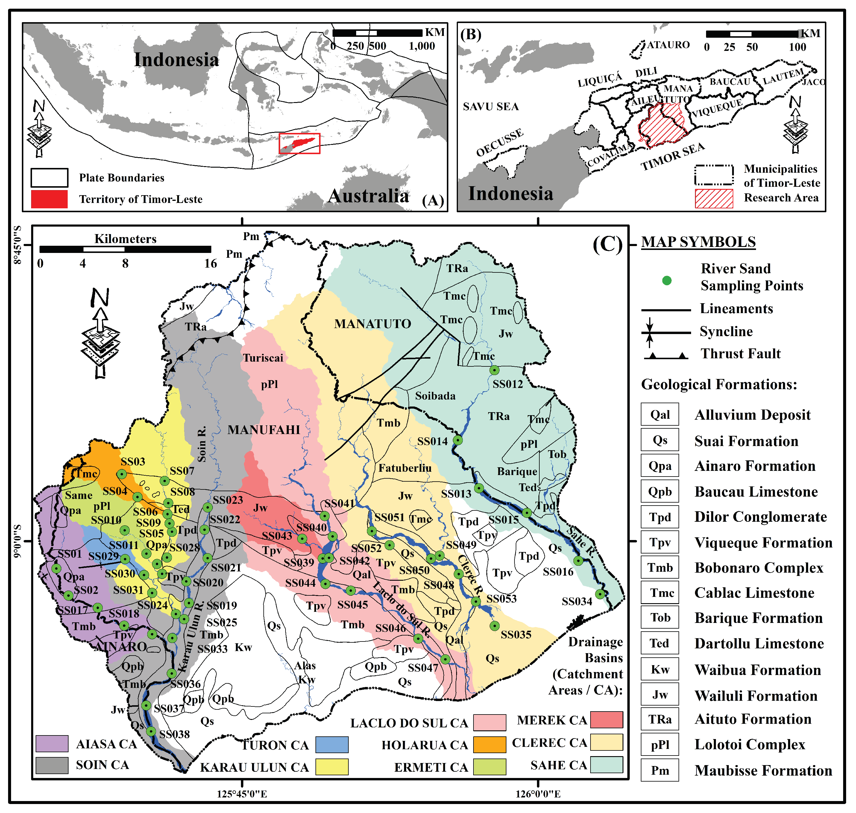
Figure 2.
Geological map (adopted from Bachri and Situmorang, 1994; Partoyo et al., 1995) and spatial distribution of major element composition values in the study area. (A) ; (B) ; (C) ; (D) ; (E) ; (F) ; (G) ; (H) ; (I) ; and (J) .
Figure 2.
Geological map (adopted from Bachri and Situmorang, 1994; Partoyo et al., 1995) and spatial distribution of major element composition values in the study area. (A) ; (B) ; (C) ; (D) ; (E) ; (F) ; (G) ; (H) ; (I) ; and (J) .
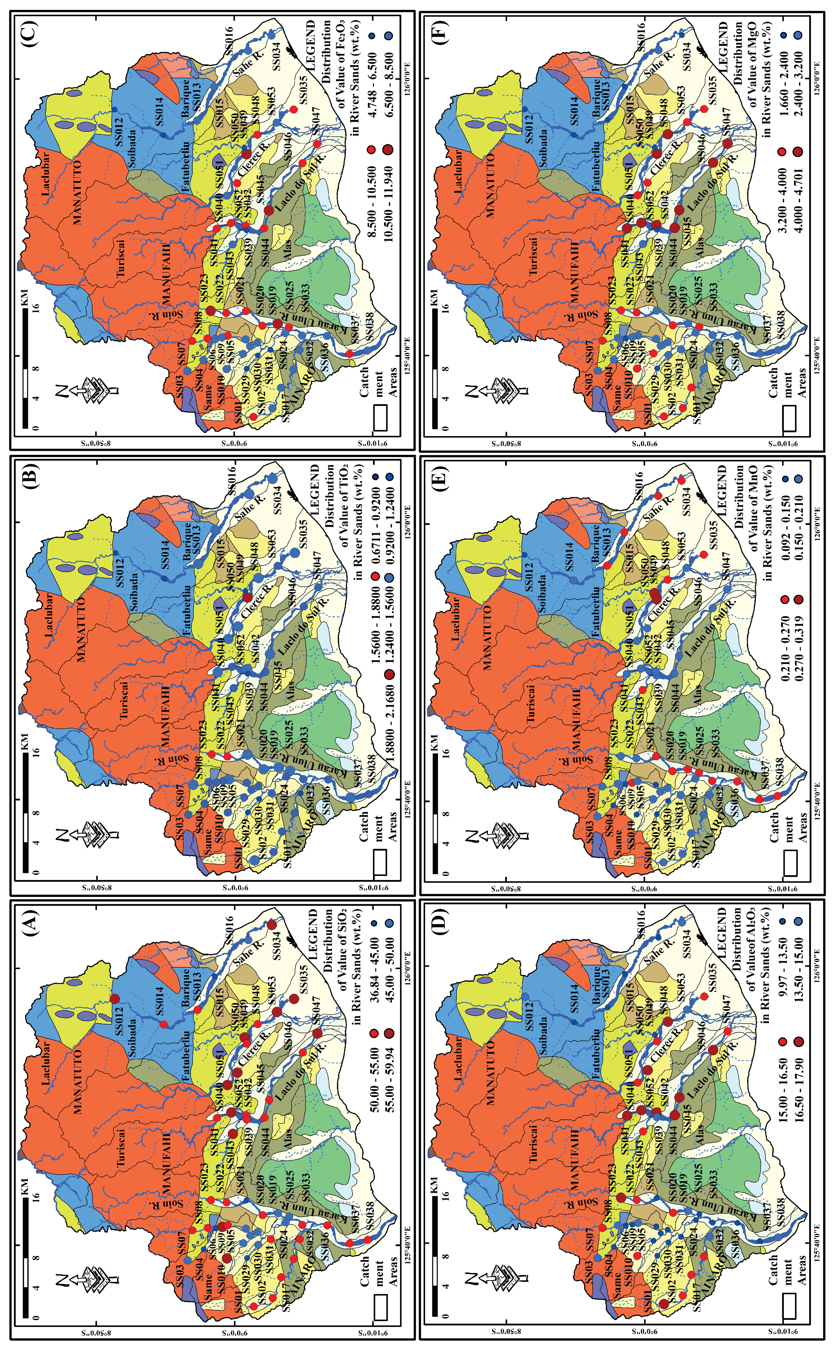
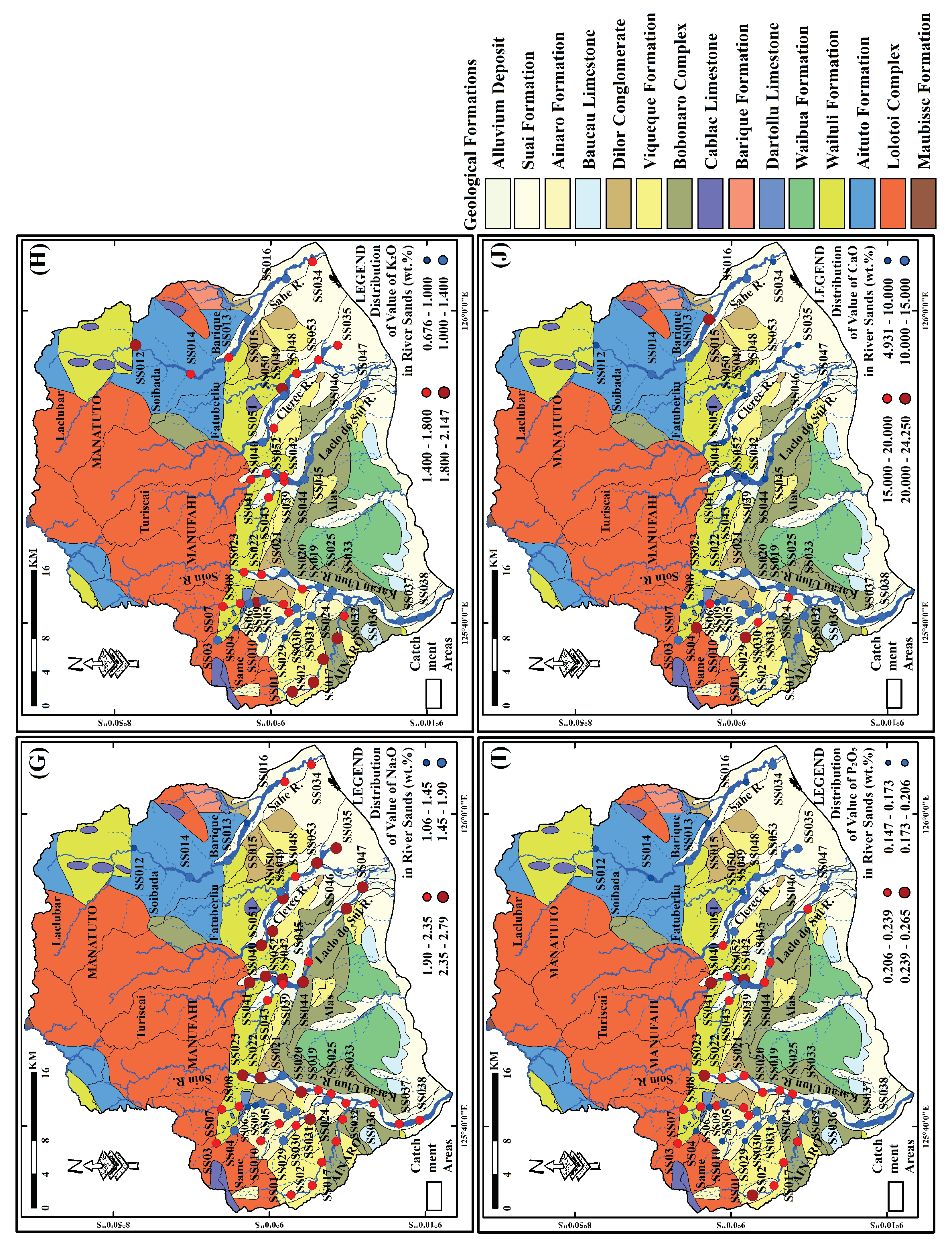
Figure 3.
Field photos showing the condition of the sampling points. (A) SS014, Sahe River; and (B) SS02, Aiasa River.
Figure 3.
Field photos showing the condition of the sampling points. (A) SS014, Sahe River; and (B) SS02, Aiasa River.

Figure 4.
Spider plots of the major element compositions. They are normalized using (A) the upper continental crust (UCC; Data from Rudnick and Gao, 2003) and (B) Post-Archaean Australian Shale (PAAS; Data from Taylor and McLennan, 1985).
Figure 4.
Spider plots of the major element compositions. They are normalized using (A) the upper continental crust (UCC; Data from Rudnick and Gao, 2003) and (B) Post-Archaean Australian Shale (PAAS; Data from Taylor and McLennan, 1985).
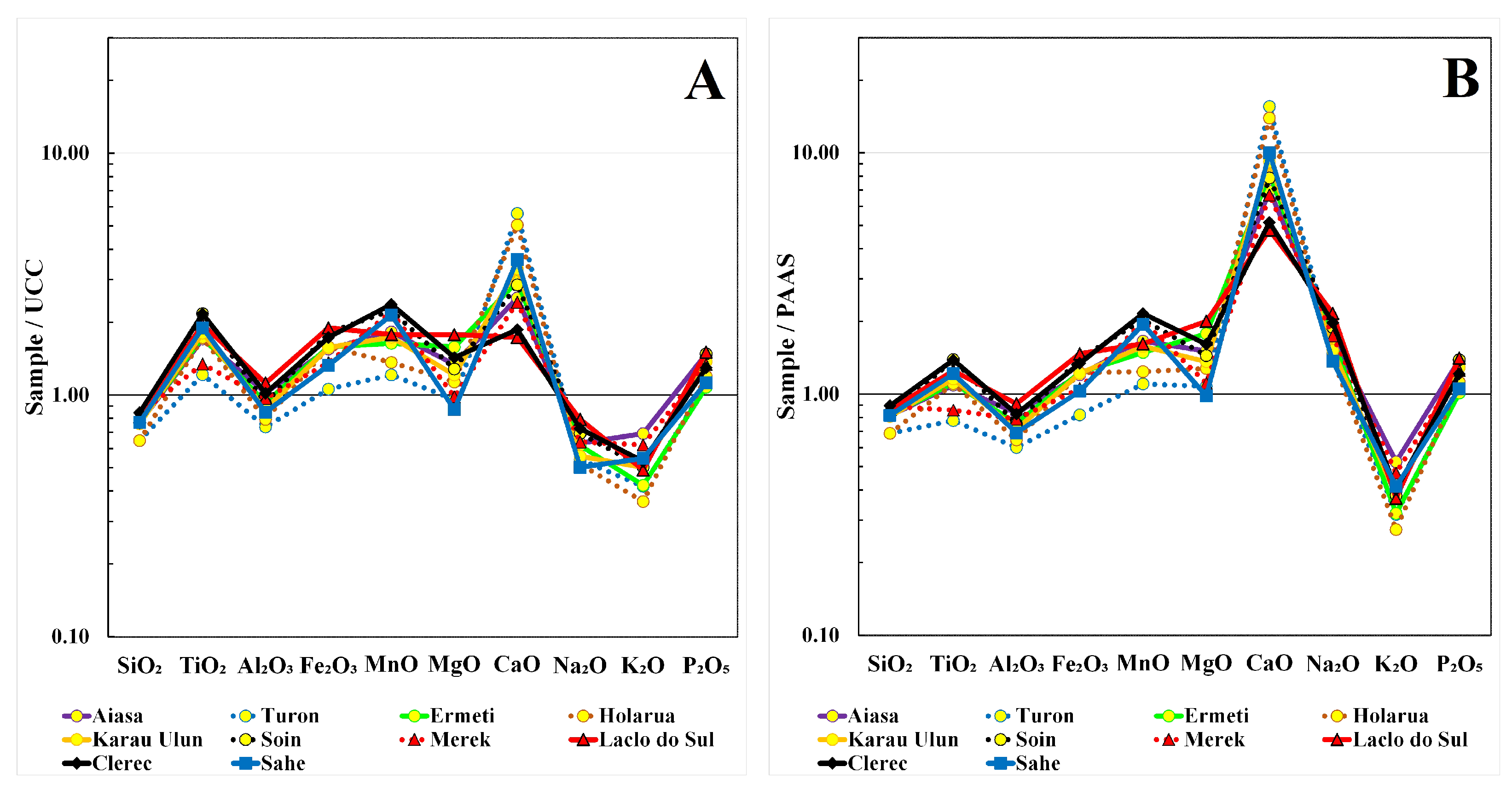
Figure 5.
Geological map (adopted from Bachri and Situmorang, 1994; Partoyo et al., 1995) and spatial distribution of / ratio in the study area.
Figure 5.
Geological map (adopted from Bachri and Situmorang, 1994; Partoyo et al., 1995) and spatial distribution of / ratio in the study area.
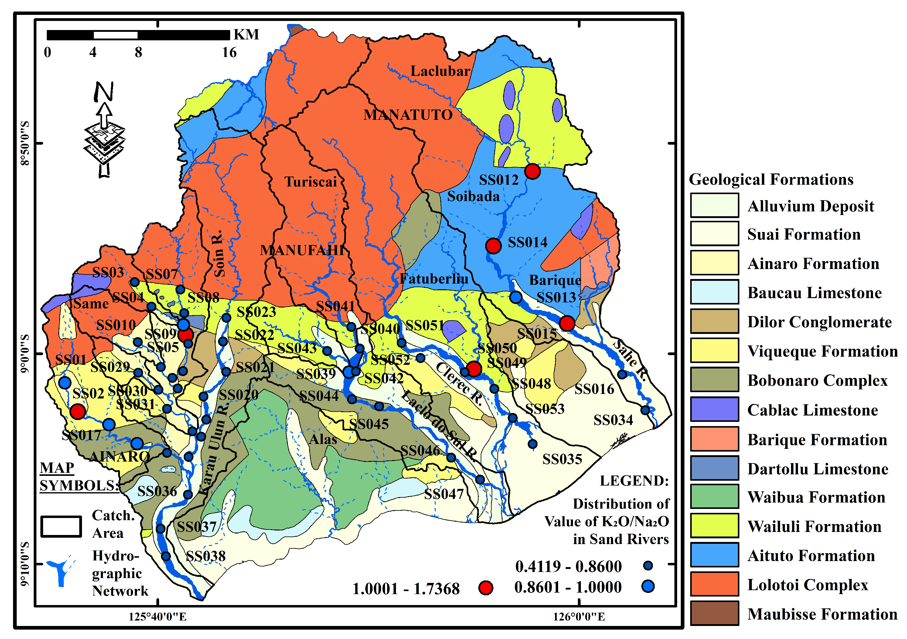
Figure 6.
A scree plot showing eigenvalues of each principal component.
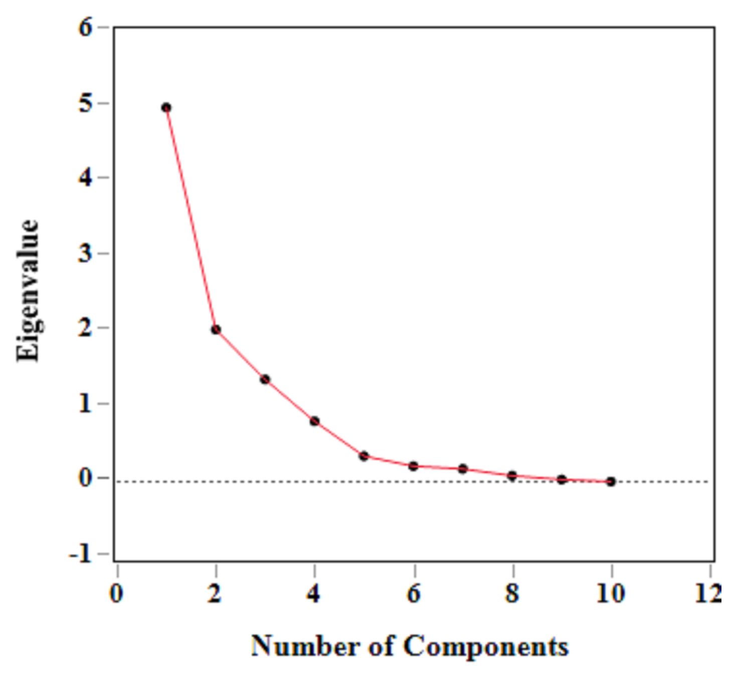
Figure 7.
Component pattern plot of the first and second principal components for samples (A) and variables (B).
Figure 7.
Component pattern plot of the first and second principal components for samples (A) and variables (B).
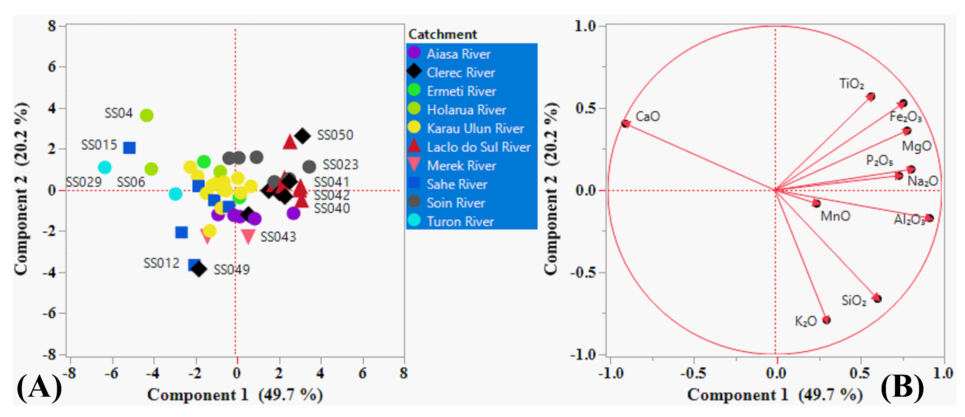
Figure 8.
Component pattern plot of the first and third principal components for samples (A) and variables (B).
Figure 8.
Component pattern plot of the first and third principal components for samples (A) and variables (B).
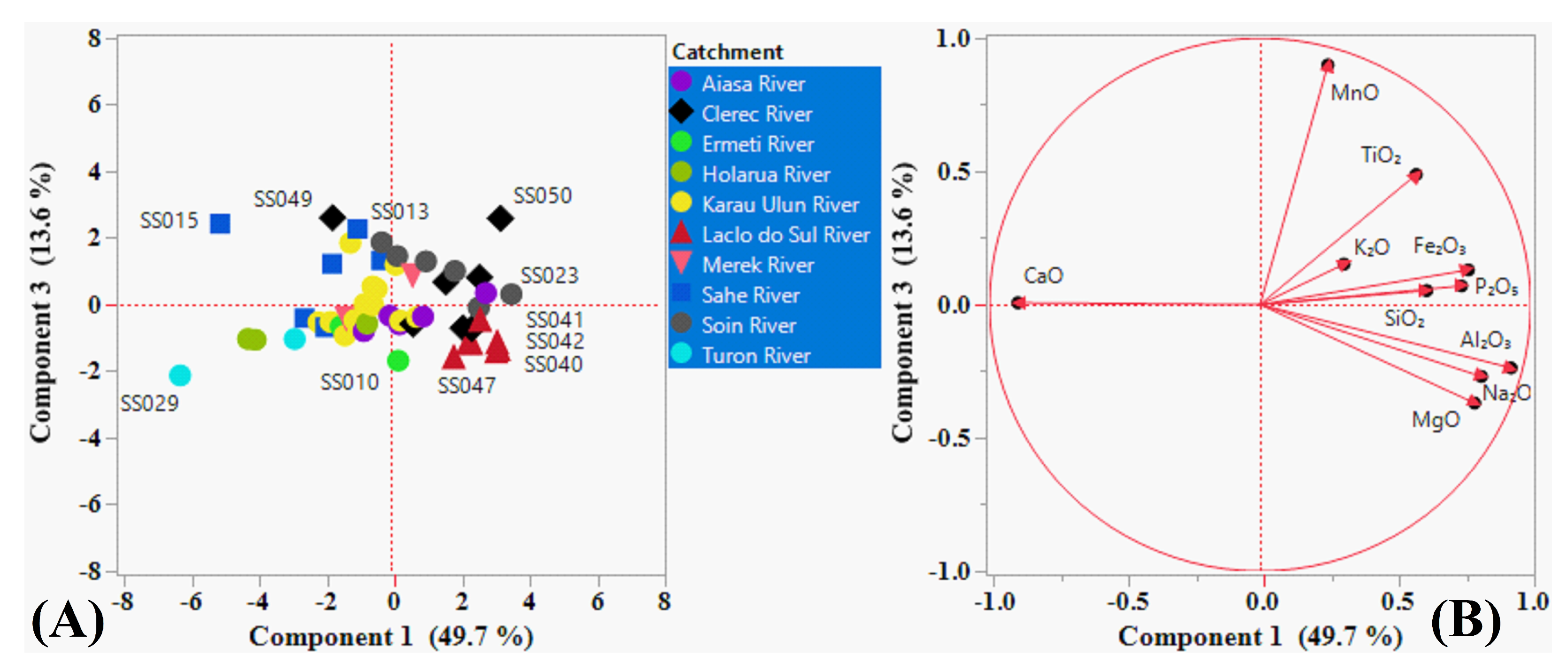
Table 1.
Statistical summary of the major element compositions along with some selected ratios and ICV of the river sand samples from the study area.
Table 1.
Statistical summary of the major element compositions along with some selected ratios and ICV of the river sand samples from the study area.
 |
Note: Post-Archean Australian Shales (PAAS; Data from Taylor and McLennan, 1985) and upper continental crust (UCC; Data from Rudnick and Gao, 2003) values are also presented for comparison. ICV = index of compositional variability; Min. = minimum; Max.= maximum; Avg. = average; and Std. = standard deviation.
Table 2.
Correlation coefficient matrix (Pearson) between major element compositions of the river sand samples from each river catchment in the study area. (A) Soin; (B) Laclo do Sul; (C) Clerec; and (D) Sahe.
Table 2.
Correlation coefficient matrix (Pearson) between major element compositions of the river sand samples from each river catchment in the study area. (A) Soin; (B) Laclo do Sul; (C) Clerec; and (D) Sahe.
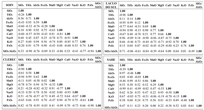 |
Disclaimer/Publisher’s Note: The statements, opinions and data contained in all publications are solely those of the individual author(s) and contributor(s) and not of MDPI and/or the editor(s). MDPI and/or the editor(s) disclaim responsibility for any injury to people or property resulting from any ideas, methods, instructions or products referred to in the content. |
© 2024 by the authors. Licensee MDPI, Basel, Switzerland. This article is an open access article distributed under the terms and conditions of the Creative Commons Attribution (CC BY) license (http://creativecommons.org/licenses/by/4.0/).
Copyright: This open access article is published under a Creative Commons CC BY 4.0 license, which permit the free download, distribution, and reuse, provided that the author and preprint are cited in any reuse.


