
Submitted:
19 February 2024
Posted:
20 February 2024
You are already at the latest version
Abstract
Environmental monitoring programs rely on periodic spot sampling at specific locations, followed by laboratory analysis, aiming at the evaluation of water quality at a catchment scale. For this purpose, automatic telemetric stations for specific parameters have been installed by the Institute of Marine Biological Resources and Inland Waters of Hellenic Centre for Marine Research (IMBRIW-HCMR) within several Greek rivers and lakes, providing continuous and temporal monitoring possibilities. Nevertheless, the employment of unmanned surface vehicles (USV) equipped with integrated sensors represents a tool valuable to several monitoring strategies, offering enhanced temporal and spatial coverage over specific timeframes, allowing for targeted examination of sites or events of interest. The USVs have been deployed by Athens Water and Sewerage Company (EYDAP) as a cost-effective tool for the environmental monitoring of surface water bodies of interest, with emphasis on the spatial fluctuations of chlorophyllα, electrical conductivity, dissolved oxygen and pH, observed in Koumoundourou Lake and rivers Acheloos, Asopos and Kifissos. The effectiveness of an innovative heavy metal (HM) system installed in the USV for thein situ determination of copper and lead was also evaluated herewith. The results obtained demonstrate that both the timely detection of potential pollution from both anthropogenic activities and natural processes as well as the monitoring of inland waters are made feasible through the employment of USV.
Keywords:
remote sensing
; water quality
; autonomous USV
; inland and coastal waters
; telemetric stations
1. Introduction
The preservation of water ecosystems and their biodiversity is directly linked to human development. Therefore, it is crucial for catchments to maintain their water quality conditions and strive, if possible, to achieve a high ecological and chemical status by the year 2027 [1,2,3]. Greek catchments face several key anthropogenic pressures derived by industrial activities, extensive livestock farming in sub-basins draining into lakes or rivers and agricultural practices [4]. Additional activities potentially affecting water resources comprise fisheries, hydropower, recreation and cultural practices within the catchment area, including water abstraction for irrigation and drinking purposes [5]. These anthropogenic pressures encompass also various water quality challenges related to eutrophication and thus to occasional algae blooms [6].
Gaining attention in the global discourse on water policy, catchments have been of high priority during the last decades. In this context, Integrated Water Resources Management (IWRM) is increasingly recognized as a holistic approach, involving all relevant stakeholders, for effectively addressing water issues at the river basin level [7,8]. IWRM should incorporate specific characteristics unique to basins, leading to the development of Integrated Lake Basin Management (ILBM). However, the effectiveness of available catchment basin management schemes and practices, referring to individual basins, should be necessarily evaluated [9].
In the framework of comprehensive surveys conducted over the past decades on the state of the world’s catchments [10,11,12,13], relevant review questions have been organized into six thematic domains, constituting the essential elements of governance that collectively form the management regime for the integrated approach to catchment management encapsulated within Integrated Lake Basin Management (ILBM).
- nstitutions: Managing a catchment and its basin for the benefit of all resource users.
- Policies: Governing people’s use of catchment resources and their impacts.
- Involvement: Engaging people in all aspects of catchment management.
- Technology: Exploring possibilities and limitations that influence long-term decisions.
- Knowledge: Integrating traditional and modern scientific knowledge as the basis for informed decision-making.
- Finance: Ensuring sustainable financial support for the implementation of the aforementioned activities.
Strategies for monitoring water quality are vulnerable to the irregular and unpredictable nature of precipitation events and hazardous incidents, such as sewage discharge, combined sewer overflows and agricultural runoff, which can impact drinking water resources and recreational water bodies [6,12]. These events occur sporadically and are often not captured by traditional monitoring approaches, which are characterized by limitations in terms of their temporal and spatial scope [14,15]. Such limitations hinder the assessment of water-related pressures and the development of effective countermeasures [16]. While automatic monitoring stations offer the potential for near real-time monitoring of basic water quantity and quality parameters, they are constrained by their point measurement nature, requiring significant investments to achieve the desired spatial resolution [17].
The need for an enhanced monitoring strategy yielding complete datasets with higher spatial resolution has become critical, requiring an approach which would enable the prediction of water quality at the catchment scale and pave the way for its improvement [18,19,20,21,22].
Into the framework of Horizon 2020 INTCATCH project (G.A. No 689341) a range of USVs has been developed and demonstrated along Europe. These prototypes USVs that can be controlled remotely or can use an autonomous sailing mode are equipped with innovative commercial systems providing valuable data on various aspects of water quality. The main parameters are physical such as electrical conductivity and temperature, chemical such as dissolved oxygen, pH and metals, as well as biological such as Chlorophyll α. All those parameters constitute variable ecological quality elements both spatially and temporally, the reliable assessment of which requires the availability of multi-year monitoring data. USVs application eliminates the need for labor-intensive and expensive monitoring methods, assuring more efficient processes.
The main objective of the present work is to demonstrate the advantages of employing innovative and integrated USVs alongside telemetric stations within existing monitoring strategies for rivers and lakes in Greece, in order to achieve a more comprehensive evaluation of water quality. These water bodies, likely play crucial roles in the local ecosystems and communities they serve. Monitoring their water quality using advanced technologies like USVs can provide valuable insight into the ecological status of these aquatic environments. Given the diverse nature of the study area—incorporating both a lake and multiple rivers—it is likely that data collected from USVs and potentially integrated with telemetric stations would offer a comprehensive understanding of water quality dynamics across different water bodies. This comprehensive approach enables the identification of specific issues, trends, or variations in water quality parameters across these varied environments.
2. Materials and Methods
2.1. Unmanned Surface Vehicles operation and description
Athens Water and Sewerage Company S.A has been responsible since 2019 for the introduction and validation of USVs application within Greek catchments into the framework of Horizon 2020 INTCATCH project. The system structure consists of an unmanned surface vehicle of one meter length approximately (Figure 1) and several electronic components, facilitating boat control and sensor data acquisition. The USV can be either operated directly using an RC device or controlled via a tablet, which provides high-level instructions such as monitoring of a predefined area using autonomous navigation [23,24]. Data collected are streamed in real-time to a cloud-based information system [25]. Data stored in the cloud-based system can be downloaded or accessed through a web-based application for visualization. During the data collection campaign, a mobile application [26,27] allows for real-time visualization of the data, presenting the results obtained using the specific color patterns of blue, green, yellow, orange, and red, complying with an increasing values scale (Waquin). All USVs prototypes were equipped with appropriate sensors for the monitoring of standard parameters such as Dissolved Oxygen (DO), Temperature (T), pH and Electrical Conductivity (EC). Among them, two USVs had additionally a Chlorophyllα (Chlα) sensor and a heavy metal (HM) sensing system, respectively. Those two autonomous USVs were employed herewith, namely ‘Chlα USV’ for ecosystem ecology monitoring and ‘HM and Sampling USV’ for autonomous sample collection and measurement of water pollution.
Chlα USV: This USV (Figure 1a) is equipped with the Turner Designs CYCLOPS-7 Submersible Fluorometer/Turbidimeter, an accurate single channel detector measuring chlorophyll αwith a detection limit of 0.03 μg L-1. A set of three additional probes provides measurements of Dissolved Oxygen (DO) at a range of 0-20 mg L-1 with a resolution of 0.1 mg L-1 and a measuring frequency of ≥1 s, Temperature (T) at a range of 0-50°C, pH with a resolution of 0.05 and Electrical Conductivity (EC) at a range of 40-4000 μS cm-1 and a resolution of 1 μS cm-1.
HM and Sampling USV: Besides the basic set of probes measuring standard parameters (DO, T, pH and EC), this USV (Figure 1b) is equipped with an easy to use system for Pb and Cu measurement by the Square Wave Anodic Stripping Voltammetry (SWASV) method, enabling also the collection of four (4) different water samples of 0.5 L each, using peristaltic pumps.
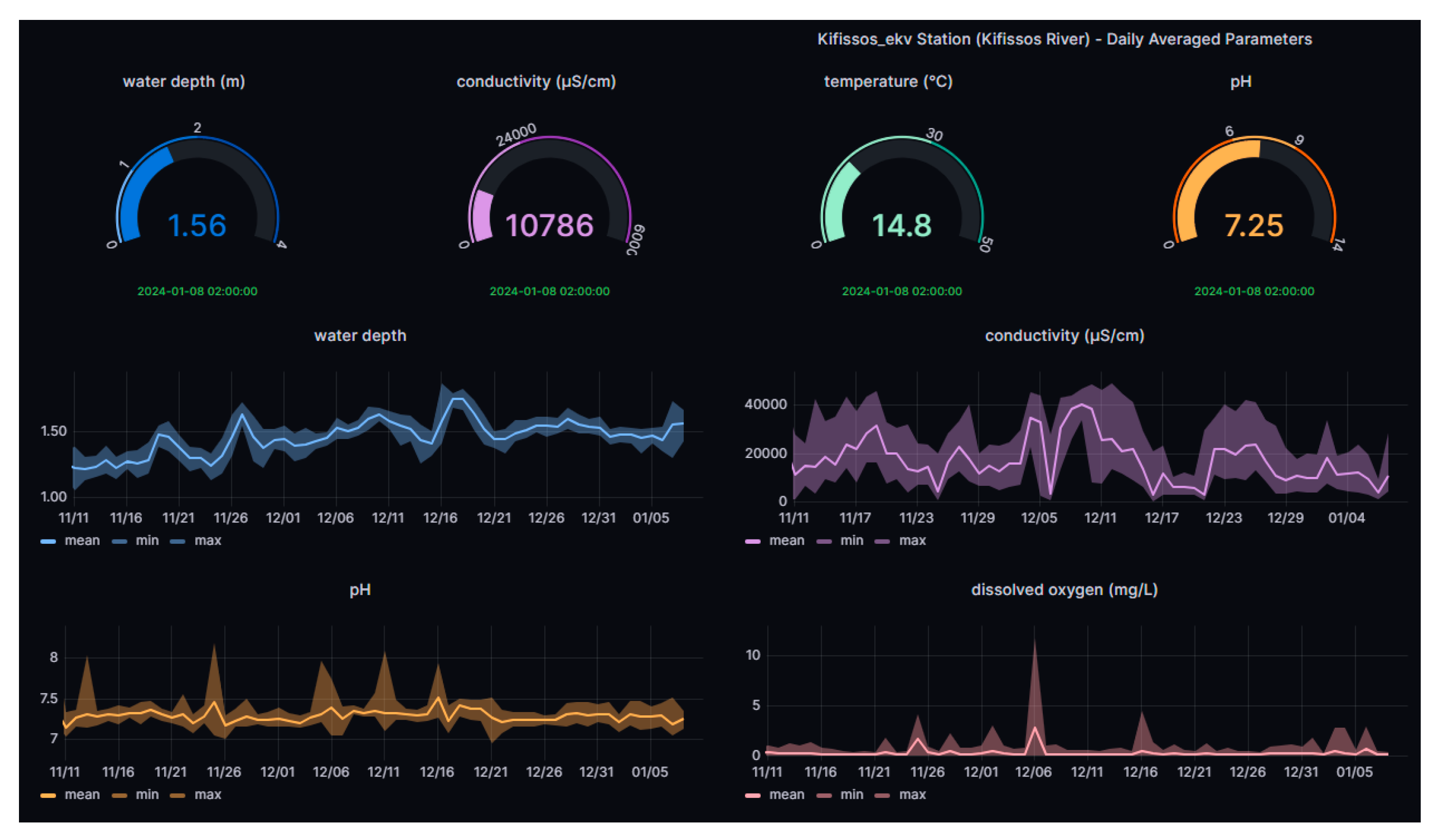
2.2. Hydro-Telemetric Stations
The Institute of Marine Biological Resources and Inland Waters (IMBRIW) of the Hellenic Centre for Marine Research (HCMR) has established an extended network of automatic telemetric stations across various lakes and rivers in Greece [28]. Stations situated at Koumoundourou Lake and Kifissos estuaries (Table 1, Figure 2) provide real-time data at an hourly basis for parameters including water level, pH, Electrical Conductivity (EC), Temperature (T), Dissolved Oxygen (DO) and Oxidation-Reduction Potential (ORP). At the telemetric station within Koumoundourou Lake salinity measurements are also recorded together with the daily averaged quality index based on DO [29] and the Canadian Council of Ministers of the Environment Water Quality Index (CCMEWQI) [30] fluctuation.

Table 1.
Automatic telemetric stations of IMBRIW -HCMR.
| Station | Latitude/ Longitude | Altitude | Installation date | Website |
| Koumoundourou lake | 38.0235/ 23.6018 | 0.83 | 28/03/2011 | http://t.ly/p85TU |
| Kifissos estuaries |
37.9472/ 23.6727 | 3.35 | 15/07/2020 | http://t.ly/UASuZ |
Figure 2.
Dynamic real-time visualization platform.
2.3. Metals System
The low-cost fluidic innovative metals system is based on the method of Square Wave Anodic Stripping Voltammetry (SW-ASV) for the determination of lead (Pb) and copper (Cu). The performance characteristics of the measuring system installed on the USV for the analysis of Pb and Cu are obtained under controlled laboratory conditions, utilizing a calibration curve prepared with mixed solutions of Cu and Pb, with a Pb:Cu ratio 1:4 [31]. The limits of detection (LOD) were estimated to be equal to 4 and 7µg L-1 for Pb and Cu respectively. Measurement precision levels, evaluated as reproducibility and given as relative standard deviation (RSD in %), were 11–18% and 6–10% for Pb and Cu, respectively, which is considered satisfactory for on-site measuring systems [32].
The Square Wave Anodic Stripping VoltammetryHeavy Metal Systemoperates following several sequential steps [31]:
- Conditioning Step: The working electrode is subjected to a positive potential (or at least 0.0 V) to prepare for the subsequent steps with a deposition time of 180 s.
- Deposition Step: A deposition potential is applied to the working electrode, causing the reduction and deposition of certain metals or other species present in the sample onto the electrode surface. The deposition process occurred, based on mass transport, and typically occurs at a thin interface between sample and electrode with a potential from −1.2 to −1 V [31] for 200 s. In flow-through mode or under stirring conditions, an increase in the signal can be observed.
- Equilibration Step: It allows for the equalization of ion concentrations within the boundaries of the electrode surface, ensuring uniformity prior to proceeding to the next step. The equilibrium step applied for 20 s, while the peristaltic pump was stopped.
- Stripping Step: Metals previously reduced and deposited onto the electrode during the deposition step are now released (oxidized) by applying a square wave potential within a specific range. Each metal undergoes oxidation at a specific potential value, resulting in the recording of various peaks at different potentials. The electrical current measured during this process is proportional to the concentration of the metals. Metal concentrations in the sample solution are determined through the interpretation of the voltammograms obtained using appropriate software. The peak height or area is compared to standard concentrations for calculation purposes.
To perform the above method, a metals measuring system is required, including a potentiostat, a sensing electrode system (screen-printed sensors), a flow cell, a peristaltic pump, software, and a data processing system [31,32].
An electrochemical analytical system was developed and optimized exclusively in the framework of INTCATCH project for detecting heavy metals in surface water [32]. The system consists of a miniaturized sensing device integrated into a microfluidic flow cell, which is part of a flow system including a pump, a gas bubble trap and a data acquisition device. Initial tests were conducted using synthetic water samples containing cadmium, copper, lead and zinc, in order to evaluate the capabilities of this technology.
Following its performance evaluation with real water samples in the laboratory, the device was successfully integrated into the INTCATCH USV, creating an autonomous and remote-controlled system, capable of detecting lead and copper in surface waters and simultaneously collecting water samples. This integrated system underwent validation through indoor and outdoor experiments at University of Natural Resources and Life Sciences in Vienna (BOKU) and was provided to the INTCATCH end-users for further validation and use [32].
2.4. Study Area and Data Collection
Introducing an innovative water quality monitoring strategy in Greece using Unmanned Surface Vehicles (USVs) for the first time in 2019 is a significant step toward enhancing environmental monitoring practices in the country. The study area comprising Koumoundourou Lake and three rivers—Acheloos, Asopos, and Kifissos—holds immense importance in understanding and managing Greece’s water resources (Figure 3).
2.4.1. Koumoundourou Lake
Koumoundourou Lake is located at Western Attica, close to the municipalities of Elefsis and Aspropyrgos. It is a lagoon with a mean depth 1.5m, laying upon the sea level, very close to the coasts of Elefsis Bay and separated from the sea by the Athens - Corinth National Highway [33]. Its water is brackish, also receiving freshwaters. The lake was artificially created in antiquity when the construction of a coastal embankment blocked the passage of waters of adjacent springs towards the sea. At the same time, the communication between Koumoundourou Lake and Elefsis Bay was accomplished through a channel mobilizing a water mill. The coastal embankment is believed to be constructed by the Boeotian tribe Minyans, while the lake must had been created between 13th and 12th century B.C. Koumoundourou Lake has been declared as a protected archaeological site with a 50 m protection zone surrounding the lagoon (Official Journal of the Hellenic Republic 5/B/8.1.1974) and an Area of Outstanding Natural Beauty (site code: AT2011014), while it is included in MedWet wetland database (site code: GR300318000). However, its position nearby the industrial area of Skaramangas - Aspropyrgos has resulted in a highly polluted lake system. Demonstration of ‘Chlα’ and ‘HM and Sampling’ USVs was performed in May 2019 at Koumoundourou Lake, collecting more than 30,000 data of physicochemical parameters, covering almost its entire surface and three nearshore stations (demo, pumping and dam station).
2.4.2. Acheloos River
Acheloos River is the second longest river in Greece (Figure 3). Its total length, extending from its sources in the mountains of Pindos (Mount Lamkos or Peristeri) to its estuary at the border with the Ionian Sea (west of Aetoliko-Mesolongi lagoons), is 255 km, while its total catchment area occupies a surface of 6468 km2, with a maximum altitude of 2470m [32]. The lower part of Acheloos valley consists of three distinct sections (a) a plain within Agrinio basin with a few meters depth, (b) the area enclosed within the limestone deposits of Palaiomanina –Stamna- Katochi with 18 km length and up to 100 m width, (c) the deltaic part of Occupancy - estuary. In the present study, ‘Chla USV’ headed initially downstream from Neochori to Katochi bridge and subsequently upstream to Neochori, covering a total distance of 2.5km. According to the typology of the rivers of Greece [35,36], the study section is classified as type R-M3 (large rivers with mixed geology and highly seasonal flow), characterized by good chemical status [37]. Upstream the study area three dams constituting the Acheloos hydro-system scheme have been constructed to meet irrigation, hydropower, domestic and flood control needs. In September 2019, water quality monitoring was carried out in Acheloos River using the ‘Chlα USV’. More than 10,000 data of physico-chemical parameters, along a 2.5 km route upstream and downstream the river, from Neochori to Katochi bridge, were collected.
2.4.3. Kifissos River
Kifissos River is the principal river of Attica region, with its lower part flowing in parallel or below highway 1, linking Athens and Thessaloniki, before reaching Faliro Bay within the Saronic Gulf. Kifissos is classified as river type R-M2 (medium rivers with mixed geology and highly seasonal flow), being the largest river of Attica Basin [37]. It has a length of 29 km, of which 14 km are within the urban area. Its catchment area is 420 km², flowing through the central-western part of Attica prefecture. The river, the sources of which are situated in the mountains of Parnitha and Penteli, simultaneously collects water from the mountains Aigaleo and Poikilo. It gathers 67% of the basin rainwater, being the main recipient of Attica. The floods that have occurred since ancient times, as well as the continuous expansion of the city limits, have led to interventions for the settlement of Kifissos, which were gradually completed in conjunction with the creation of Kifissos avenue, in 2004. In July 2020, monitoring of the water quality of Kifissos River was carried out with ‘Chlα USV’ and the research team collected approximately 15,000 data of physico-chemical parameters, along a 2 km stretch downstream of the river, from its mouth at Athens Marina to Piraeus Avenue (Moschato area).
2.4.4. Asopos River
Asopos is classified as river type R-M2 (medium rivers with mixed geology and highly seasonal flow), with a length of 64 km, flowing along the borders of Boeotia and Attica Prefectures [37]. It originates from Kithaironas mountain and empties into the southern Evoikos Gulf at the coastal area of Chalkoutsi town, representing in ancient times the physical border between the cities of Thebes and Plataea. Special conditions developing in Athens metropolitan area since the 1970s, such as population growth, changes in social composition, increase in land prices, environmental pressures and urbanization of peri-urban areas, have provoked the installation and operation of nuisance industrial units of the secondary sector within the proximate Asopos area studied herewith. Within the catchment area of Asopos, populated with approximately 70,000 inhabitants, very intense industrial and agricultural activity has been developed, leading to its consideration as one of the most polluted streams of Greece. Environmental pollution in Asopos waters became known in August 2007 when measurements by the General State Laboratory and other accredited laboratories, detected the presence, among others, of hexavalent chromium in the water table of the area [34,38]. Monitoring of water quality at the mouth of Asopos River in Chalkoutsi was carried out in October 2019. The ‘HM and Sampling’ USV collected data of physicochemical parameters and heavy metals (copper and lead).
3. Results and Discussion
Given the diverse nature of the study areas—comprising both a lake and multiple rivers—it’s likely that the data collected from USVs and potentially integrated with telemetric stations would offer a comprehensive understanding of water quality dynamics across different water bodies. This comprehensive approach enables the identification of specific issues, trends, or variations in water quality parameters across these varied environments.
3.1. USV Campaigns for Physicochemical Parameters in Greece
3.1.1. Chlorophyll α
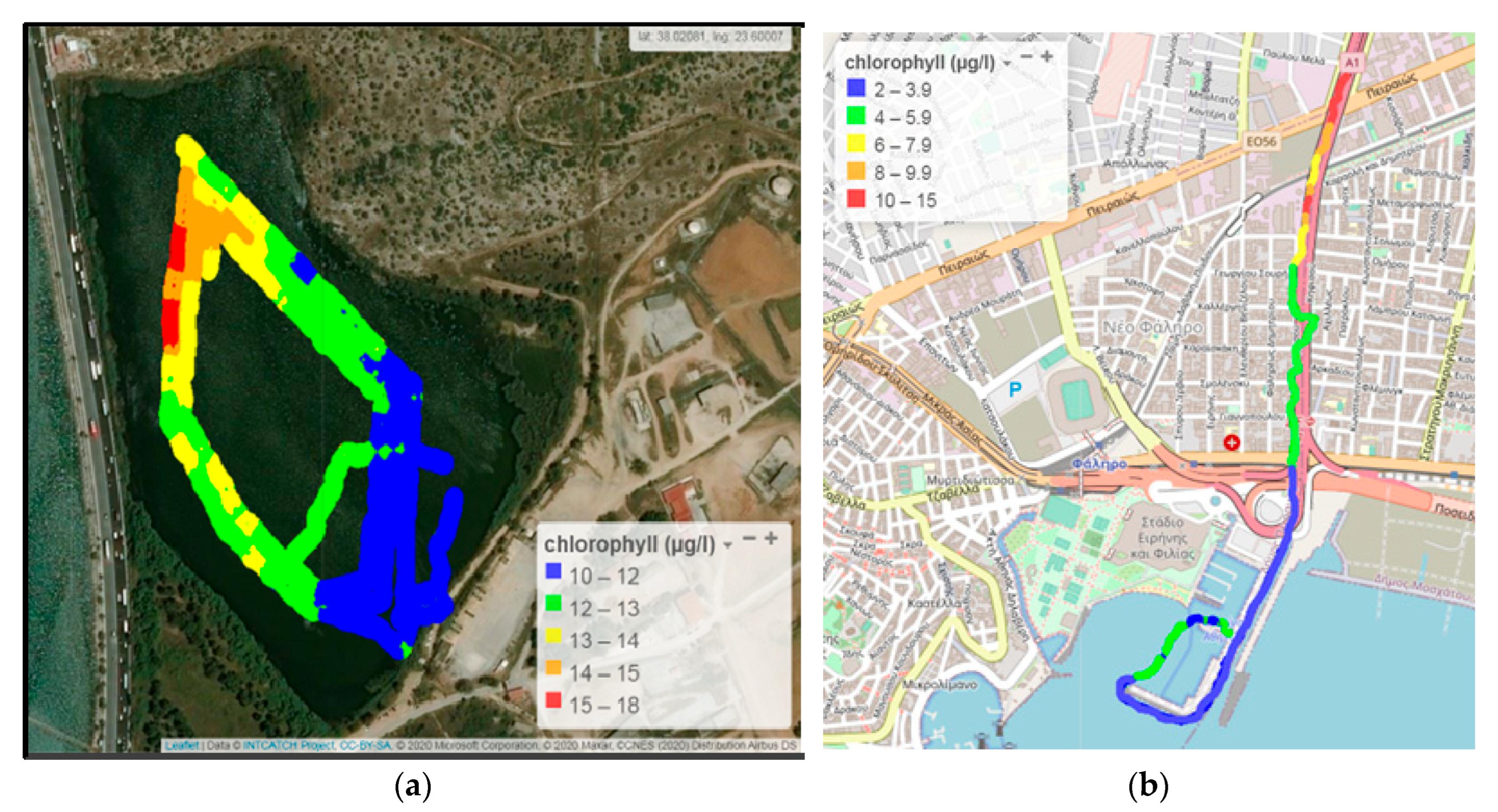
Within an hour, the unmanned boats had covered the longest part of the inner perimeter of Koumoundourou Lake. The concentration of Chlα ranged from 10.0 to 17.5 μg L-1 and was higher along the northeast part of the lake, north of the gate (Figure 4a), probably due to water circulation towards this direction and influx of groundwater. Evaluating the results obtained for Chla and utilizing the ECOFRAME system [39] to classify the ecological quality of shallow lake water, Koumoundourou Lake falls within the “good” (Chla; 11-20 μg L-1) classification, that aligns with earlier studies [40].
The concentrations of Chlα within the Kifissos estuary (Figure 4b) ranged from 2.0 to 15 μg L-1, with the average value being equal to 5.7 µg L-1. Significantly higher Chlα concentrations (maximum value 15 μg L-1) were found upstream, near Piraeus Avenue and Piraeus station of the urban railway line (Figure 3b). These might be attributed to organic matter accumulation during the inflow of the sea front upstream of the river bed. The spatial distribution of Chlα demonstrates a decreasing trend of its concentration towards the river estuary and the artificial bed close to Athens Marina.
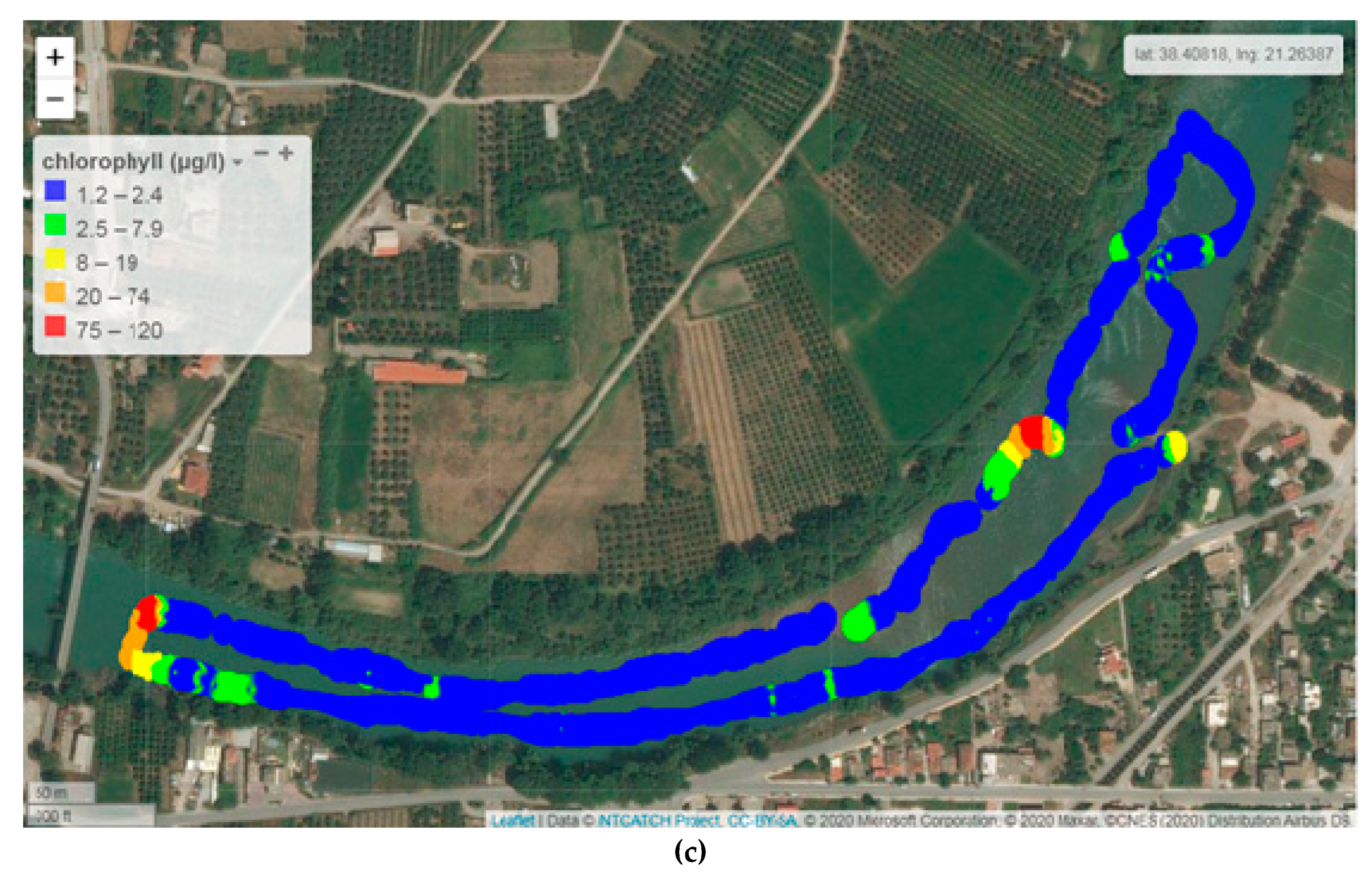
The concentrations of Chlα in the study area of Acheloos river ranged from 1.2 to 120 μg L-1 with a mean value of 5.2 μg L-1(Figure 4c). Significantly higher values were found downstream, nearby Katochi bridge (maximum value 120 μg L-1) and opposite to Neochori village (maximum value 80 μg L-1), possibly attributed to plant accumulation due to meandering of the river bed and formation of shallow reefs or micro-lakes.
Figure 4.
Chlα by the Waquin application of INTCATCH in (a) Koumoundourou Lake, (b) Kifissos river and (c) Acheloos river.
Figure 4.
Chlα by the Waquin application of INTCATCH in (a) Koumoundourou Lake, (b) Kifissos river and (c) Acheloos river.
3.1.2. Conductivity
Conductivity in Koumoundourou Lake ranged from 2800 to 3050 µS cm-1 (Figure 5a) with its values continuing the steady decreasing trend recorded by HCMR studies from 1984 until today [40,41]. On 28/05/2019 the telemetric station of Koumoundourou Lake recorded a value of 10,820 μS cm-1. Monitoring sensors of the telemetric station have been installed near the lake bottom, while the sampling conducted by unmanned boats was surficial. This may explain the difference in the recorded values since the lake bottom lies below the sea level and is mostly affected by seawater, while the freshwater originating from springs at the periphery of the lake forms a surface layer separated from the underneath saltwater due to their density difference. Maximum values were measured northeast, indicating a small inflow of seawater mixing through the underground inlets. In the study area of Kifissos estuary, in the summer of 2020, conductivity was measured ranging from 1,400 to 3,500 μS cm-1, constituting an indication of significant inflow of the sea front, typical of brackish estuarine systems in agreement with both recent and previous studies of the research groups of IMBRIW (HCMR) and other organizations, within the specific area [40,42]. The USV sensor has an upper limit of 3,500 μS cm-1, a value determined downstream to Arkadiou Street (beginning of red line) representing IMBRIW station (Figure 5b). Parallel measurements with a portable conductivity meter showed that from Arkadiou Street to the Athens Marina conductivity values reached seawater salinity levels. Moreover, during the study period, it was expected that there would be no natural river flow resulting in significant seawater intrusion entering upstream.
In the studied part of Acheloos plain, conductivity levels are relatively low, ranging from 281 to 336 μS cm-1 (mean value 308 μS cm-1). On the USV route from Neochori downstream to Katochi bridge, two areas were distinguished in terms of conductivity, one with a conductivity range 280-299 μS cm-1, and another with 300 – 309 μS cm-1, although this difference might not be substantial but is indicative of potential sensor discrimination (Figure 5c). The highest values were measured at the shallow entry point of the USV near and upstream of Neochori (310-336 μS cm-1), probably also due to relatively higher water temperature.
3.1.3. Dissolved Oxygen
The concentration of dissolved oxygen is a reliable measure of the state and sustainability of an ecosystem. It is disrupted by either natural or human activities introducing an excess of nutrients into the water, leading to phytoplankton overgrowth and to anoxic phenomena, observed at areas close to the shore or nearby the bottom, characterized by organic matter accumulation. During summer, the concentration of dissolved oxygen on the epilimnion remains relatively high in temperate regions, owing to intense photosynthetic activity, aided by intense sunlight and atmospheric diffusion.
In Koumoundourou Lake DO values ranged from 10.5 to 11.7 mg L-1 (Figure 6a), indicating well oxygenated water. At the study area of Acheloos River (Figure 6b) the concentration of dissolved oxygen ranged between 7.9 and 8.5 mg L-1, with an average value of 8.1 mg L-1, indicating well oxygenated waters. According to the limits applied for the characterization of different water quality classes set by the French SEQ System (Système d’évaluation de la qualité de l’eau des cours d’eau/ SEQ-Eau), the ecological status of a river with a dissolved oxygen concentration exceeding 8.0 mg L-1 is considered ‘high’. Τhe spatial distribution of dissolved oxygen demonstrates higher concentrations (8.3 to 8.4 mg L-1) downstream of the river, nearby Neochori, attributed mainly to higher river velocity and water agitation. Simultaneously, several point intervals are recorded, mainly upstream of the river, with the concentration of dissolved oxygen remaining lower than 8.0 mg L-1 (Figure 6b, blue color illustration), consumed for the degradation of accumulated organic matter and/or other biological processes. The application of USVs permits the reliable recording of dissolved oxygen distribution in real time, with simultaneous identification of potential sources of environmental pressure, related to discharges and surface runoff.
3.1.4. pH
The pH of natural waters typically ranges between 4 and 9 units, with the range 6.5-8.5 being the most suitable for aquatic organisms. Water pH depends on various factors, including temperature, salinity (presence of sulfur anions, chlorine, cations of calcium, magnesium etc), carbon dioxide and oxygen levels, as well as metabolic activity of aquatic organisms (such as photosynthesis and respiration) and organic substances chemical decomposition. Changes in pH are typically attributed to CO2 consumption in the epilimnion due to photosynthetic activity, resulting in a subsequent increase in pH.
In Koumoundourou Lake the pH was found to be alkaline, ranging from 8.6 to 8.7 (Figure 7a), with its spatial distribution demonstrating a slight decrease in the northeastern part (nearby K4 and K5 sites), close to karst springs, attributed to fresh water inflow. According to ECOFRAME system [39], a pH range 6.0-10.0 (combined with chlα) characterizes a good quality system. The pH showed significant fluctuations in the study area of Kifissos River, ranging from 7.7 to 8.7 (Figure 7b), generally complying with the acceptable pH limits (6.5-8.5), except for specific high values measured. Higher pH values were determined upstream of the study area at the height of Piraeus Avenue, while a gradual decrease was observed towards Kifissos estuary. The comparison with the corresponding values of time series recorded for the fixed station [42] of HCMR during July-August 2020, points out that pH values approximately equal to 9 appear frequently.
3.2. ‘HM and Sampling’ USV Campaigns in Greece
HM and Sampling USV were employed in Greece from January to October 2019, used simultaneously in several demonstration activities and campaigns within Greece. The results obtained through the deployment of ‘HM and Sampling’ USV in lagoon systems and estuaries for metals measurements (in situ and in water samples) were combined (a) with those of corresponding measurements performed in natural samples obtained from the field and analysed in the Laboratory of Environmental Chemistry (LEC) of the National and Kapodistrian University of Athens (NKUA) and in EYDAP laboratory, as well as (b) with relevant data previously reported both by LEC-NKUA and in pertinent literature (Table 2 and Table 3).
The values of total PbT and CuT determined herewith for Koumoundourou Lake, affected by industrial and urban activities, through the application of USVs were respectively equal to 6.2 and lower than 0.7 mg L-1 (Table 2). These results are comparable to those recently reported for the same area (PbΤ 0.038-3.49 µg L-1 and CuΤ 0.178 -3.22 µg L-1) by the Institute of Marine Biological Resources and Inland Waters of HCMR [40,41] (Table 2). Significantly higher values were previously provided for other Greek lakes [43,44] (Table 2), with Vistonis lake of Northern Greece demonstrating the higher concentrations, supporting the considerable contribution of fertilizers and pesticides to PbT and CuT levels in lakes. The comparison among the results reported in literature indicates that emphasis should be given to their interpretation, due to the variability characterizing the analytical procedures applied.
Table 2.
Total dissolved lead (PbT) and copper (CuT) in Greek aquatic systems reported in literature.
Table 2.
Total dissolved lead (PbT) and copper (CuT) in Greek aquatic systems reported in literature.
| Fresh water system | Activity | PbT (µg L-1) | CuT (µg L-1) | Source |
|---|---|---|---|---|
| LAKES | ||||
| Koumoundourou | Industrial/Urban | 6.2 | < 0.7 | Present Study EYDAP (ICP-OES) |
| 0.038 - 3.49 | 0.178 - 3.22 | Dimitriou, 2012 [40] Koussouris, 2014 [41] |
||
| Vegoritis | Fertilizer/ pesticide | 1.2 – 24.2 | 0.7 - 15.2 | Zacharias, 2002 [43] |
| MikriPrespa | 0.2 | 14.4 | ||
| Koronia | 36.8 | 3.7-21.8 | ||
| Vistonis | 58.4 | 43.2 | ||
| Kastoria | 31.1 | 6.6-19.4 | ||
| Doirani | 22.3 | 9.6-12.4 | ||
| RIVERS | ||||
| Asopos | Industrial/Agricultural | < 0.8 | < 0.7 | Present Study EYDAP (ICP-OES) |
| Acheloos | Agricultural | 0.07-2.85 | 0.01-5.40 | Skoulikidis, 2018 [34] |
| Louros | Agricultural/Urban | 0.05-0.48 | 0.24-0.60 | |
| Asopos | Industrial/Agricultural | 0.120 - 1.42 | 0.350 - 3.25 | Botsou, 2007 [45] |
| MARINE COASTAL AREAS | ||||
| Asopos estuary | Industrial/Agricultural | 0.9 | 1.0 | Present Study EYDAP (ICP-OES) |
| Loutropygos, Elefsis gulf |
Industrial | - | 0.47-0.85 | Scoullos et al. 2007 [46] |
| Elefsis gulf | 0.05-0.34 | 0.06-0.72 | ||
| Loutropygos, Elefsis gulf |
Industrial | 0.11-0.31 | 0.40-0.76 | Sakellari et al. 2015 [47] |
| Vourkari, Elefsis gulf | Industrial | 0.03-0.18 | 0.31-1.21 | Karavoltsos et al. 2021 [48] |
| Pahi, Saronicos gulf |
Open Saronicos gulf, LNG Greek terminal | 0.08-0.21 | 0.09-0.26 | |
| Chalkis, Evoikos gulf | Urban/Industrial | 0.03-0.15 | 0.20-0.76 | |
| Asopos estuary | Industrial/Agricultural | 0.01-0.15 | 0.57 | |
| Loutropygos, Elefsis gulf |
Industrial | 0.08-0.21 | 0.09-0.26 | |
| Vourkari, Elefsis gulf | Industrial | 0.03-0.18 | 0.31-1.2 | |
| Pahi, Saronicos gulf |
Open Saronicos gulf, LNG Greek terminal | 0.11-0.31 | 0.40-0.76 | |
Table 3.
Comparison of results obtained by HM USV system (SWASV), DPASV method (LEC, NKUA) and ICP-OES method (EYDAP) for total and labile PbL and CuL, for Lake Koumoundourou (02/07/19) and Asopos river (11/10/19).
Table 3.
Comparison of results obtained by HM USV system (SWASV), DPASV method (LEC, NKUA) and ICP-OES method (EYDAP) for total and labile PbL and CuL, for Lake Koumoundourou (02/07/19) and Asopos river (11/10/19).
| Metal |
1PbL (µg L-1) |
2PbL (µg L-1) |
3PbT (µg L-1) |
4CuL (µg L-1) |
5CuL (µg L-1) |
6CuT (µg L-1) |
| Sample Name/Method | HM boat (SWASV) |
LEC (DPASV) |
EYDAP (ICP-OES) |
HM boat (SWASV) |
LEC (DPASV) |
EYDAP (ICP-OES) |
| Demostation Lake Koumoundourou |
8.06 | 0.5 | < 0.8 | 13.02 | 0.8-1.0 | < 0.7 |
| 12.07 | 7.84 | |||||
| 16.18 | 8.79 | |||||
| Pumping station Lake Koumoundourou |
17.6 | < 0.1 | 6.2 | 17.5 | < 0.1 | < 0.7 |
| 8.53 | < 7 | |||||
| 20.04 | 26.65 | |||||
| Dam station Lake Koumoundourou |
12.29 | < 0.1 | < 0.8 | < 7 | < 0.1 | < 0.7 |
| 8.09 | ||||||
| < 4 | ||||||
| Asopos River Estuary |
10.48 | < 0.1 | < 0.8 | < 7 | 0.8-1.0 | < 0.7 |
| 7.63 | < 7 | |||||
| 10.81 | 13.21 | |||||
| 10.36 | < 7 |
1HM USVPb LOD= 4 μg L-1; 2DPASVPb LOD=0.1 μg L-1; 3ICP-OESPb LOD=0.8 μg L-1; 4HM USVCu LOD=7 μg L-1; 5DPASVCu LOD=0.1 μg L-1; 6ICP-OESCu LOD=0.7 μg L-1.
Regarding river systems, ‘HM and Sampling USV’ employed in Asopos river to collect water samples, and concentrations not exceeding 0.8 and 0.7 µg L-1 for PbT and CuT, respectively, in an area affected by industrial and agricultural activities (Table 2). These results are comparable to those recently reported for the Greek rivers Acheloos [34], Louros [34] and Asopos [45], affected mainly by agricultural pressures (Table 2).
Concentrations of total dissolved PbT and CuT in the area of Asopos estuary, bearing several environmental features similar to those of a typical enclosed coastal marine area, appear comparable, however higher than those recently measured in various marine coastal areas within Elefsis [46,47,48] and Saronicos [48] gulfs (Table 2).
The HM system installed at USV is suitable for the detection of labile metals in natural aquatic systems, providing hence a significant tool for the in situ collection of analytical data. Most dissolved metals present in aquatic systems form complexes with ligands deriving either from inorganic anions or dissolved organic matter, with only a small percentage of the metals remaining in the labile form, being available for detection using the SWASV method. Under this perspective, a comparison was performed among the results obtained applying the HM USV system, with those deriving through the technique of Inductively Coupled Plasma Optical Emission Spectrometry (ICP-OES) and the electrochemical method of Differential Pulse Anodic Stripping Voltammetry (DPASV).
Following an initial testing in May 2019, the HM USV system was deployed by EYDAP in collaboration with the Laboratory of Environmental Chemistry of NKUA, in July 2019 at three near shore stations of Koumoundourou Lake (demo, pumping and dam station) and in October 2019 in Asopos river estuary (Table 3). Field sampling was performed in parallel and the samples were analysed by the ICP-OES method ISO_11885:2007, in EYDAP laboratory accredited according to ISO/EN 17025. Electrochemical measurements of labile metals (PbL and CuL) were carried out in LEC-NKUA by a voltammetric instrument (μ-AUTOLAB, Eco-Chemie, The Netherlands), connected to a three electrode cell (VA 663, Metrohm stand, Switzerland), with a static mercury drop electrode (SMDE) as the working electrode, the reference electrode Ag/AgCl (3 M KCl) and a carbon rod as the auxiliary electrode. The mode of Differential Pulse Anodic Stripping Voltammetry (DPASV) was applied.
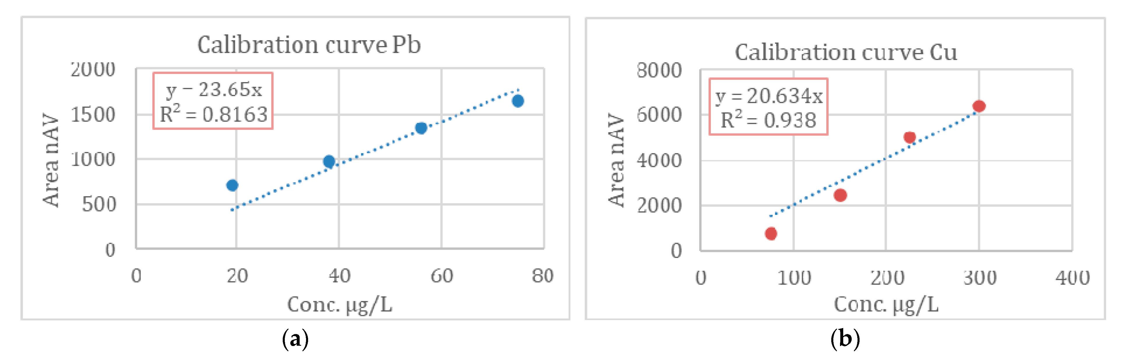
Prior to the field campaigns, calibration of the screen-printed sensor was performed in the laboratory (Figure 8). The calibration curves were generated from measurements of mixed solutions containing a 1:4 ratio Pb:Cu and performed with the previously described integrated system. For a better representation of the concentration ratio of the studied metals in real surface waters, the calibration solutions were first prepared within a concentration range of 19–75 µg L-1 for PbL and of 75–300 µg L-1 for CuL. The performance of the HM USV system was satisfactory considering the calibration procedure, with the measurements of real samples providing useful results subject to further discussions.
The results obtained indicated that even in polluted natural systems, concentrations of total dissolved metals are relatively low, while those of labile metals lie to close to the limit of detection (Table 3). Improvement of the technique sensitivity, in order to respond to the low labile metal levels present in natural systems, becomes hence more than valuable for the direct detection of labile metal fractions in the field, avoiding any pretreatment of the samples.
The developed integrated system demonstrates positive performance in terms of in situ detection of Pb and Cu concentration changes in surface water bodies within the range of several μg L-1 (4 μg L-1 for PbL and 7 μg L-1 for CuL). While this detection sensitivity addresses specific challenges such as detecting point contamination from road runoffs, misconnections and cross-connections, it may not be effective for measuring the normal concentrations of these metals in the aquatic environment. The analytical method lacks selectivity due to influences exerted from the water matrix and the concentration ratio of metals present.
4. Conclusions
The use of unmanned surface vehicles in parallel with hydro-telemetric stations achieves a thorough monitoring coverage both in space and real-time, providing a significantly higher amount of water quality data, even from hardly accessible sampling areas, without requiring any costly monitoring schemes. It also makes feasible the on time raising of alerts in the attempt of elaborating action for protecting end users. The systematic, full scale application of unmanned boats and hydro-telemetric stations could support investigative monitoring programs, representing a valid rapid tool/approach in cases of emergency (e.g., in relation to climate change events such as floods). The collaboration between EYDAP, HCMR-IMBRIW and LEC-NKUA will serve the perspective of contributing to the requirements of authorities and organizations for assessing water quality in relation to catchment management and complying with traditional sampling protocols.
The application of USVs conducted for the first time to Greek catchments and clearly demonstrated their benefits in the process of water monitoring:
- Accurate monitoring of ecological status, with emphasis on phytoplankton growth, provides valuable insights into the distribution and responses of phytoplankton to environmental pressures.
- Thorough monitoring campaign both in space and time, comprising a significantly higher amount of water quality data without requiring any labor intensive and costly monitoring schemes.
- Collection of numerous discrete samples and representative coverage of a study area (e.g., a whole lake) required for the chemical classification of a water body.
The results obtained by the deployment of USVs and telemetric stations demonstrate a clear and steady decreasing trend of conductivity in Koumoundourou Lake, with the eutrophic state of the ecosystem being in accordance with previous studies [40,41]. The application of USVs in rivers Acheloos, Asopos and Kifissos provided valuable insights into the distribution of Chla, conductivity, dissolved oxygen and pH, related to environmental pressures.
The integrated HM system developed permits the insitu detection of variations of metals (Pb, Cu) concentrations in surface water bodies, with a detection sensitivity addressing certain challenges such as detection of point contamination from road runoffs or pipeline misconnections. However, it requires certain improvements in order to overcome the limited selectivity attributed to influences from various ingredients of the water matrix and to become capable of measuring the accurate concentrations of those metals in the aquatic environment.
USVs enable a comprehensive and continuous monitoring approach, allowing for a detailed assessment of spatial and temporal variations. Comparison of data collected makes feasible the discrimination among different limnological categories and the identification of the extent of anthropogenic impacts on these water bodies. This real-time water quality reporting is crucial for effective decision-making and management. Within the framework of this innovative monitoring program, online measurements are conducted by USVs in Greek catchments, in order to capture real-time spatial information, significantly increasing the amount of available water quality data. By combining the data collected from USVs with those obtained from telemetric stations, a great amount of information is received, enabling the evaluation of lakes and rivers environmental quality. The effectiveness of these vessels in rivers and lakes has been so far evaluated by a wide range of stakeholders involved in water quality. On this basis, further development work is ongoing, aiming at enhancing sensitivity and minimizing or avoiding interferences by utilizing a fingerprinting approach.
Author Contributions
Conceptualization, G.K. and S.K.; methodology, G.K., S.K. and A.M.; software, G.K. & N.T.; validation, G.K., S.K and E.D.; testing and operation of USVs, G.K., N.T., sampling and analysis, G.K., N.T., and S.K.; resources, S.S.; data curation, G.K. and S.K.; writing—original draft preparation, G.K., A.S. and A.M.; writing—review and editing, S.K, S.S., E.D.; visualization, G.K., N.T. and A.M.; supervision, M.S.; All authors have read and agreed to the published version of the manuscript.
Funding
“This research was funded by the EUROPEAN UNION’S HORIZON 2020 research and innovation project INTCATCH “Development and application of Novel, Integrated Tools for Monitoring and Managing Catchments” under grant agreement No 689341.
Acknowledgments
The Authors would like to thank Aleko Dosi, Marina Despotidou and Giorgo Pouli for field and operation assistance as well as EYDAP’s Laboratory that is responsible for ICP-OES analyses.
Conflicts of Interest
The authors declare no conflicts of interest.
References
- European Commission. Commission Staff Working Document European Overview (1/2) Accompanying the document Report From the Commission to the European Parliament and the Council on the Implementation of the Water Framework Directive (2000/60/EC) River Basin Management Plans. Available online: https://publications.europa.eu/en/publication-detail/-/publication/85d9694d-d1d7-48bb9402-d6da989eb9df/language-en (accessed on 27 June 2019).
- Zacharias, I.; Liakou, P.; Biliani, Ir. A Review of the Status of Surface European Waters Twenty Years after WFD Introduction. Environmental Processes 2020, 7, 1023–1039. [Google Scholar] [CrossRef]
- Posthuma, L.; Zijp, M.C.; De Zwart, D.; Van de Meent, D.; Globevnik, L.; Koprivsek, M.; Focks, A.; Van Gils, J. , Birk, S. Chemical pollution imposes limitations to the ecological status of European surface waters. Scientific reports 2020, 10, 14825. [Google Scholar] [CrossRef]
- Vatitsi, K.; Ioannidou, N.; Mirli, A.; Siachalou, S.; Kagalou, If.; Latinopoulos, D.; Mallinis, G. LULC Change Effects on Environmental Quality and Ecosystem Services Using EO Data in Two Rural River Basins in Thrace, Greece. Land 2023, 12, 1140. [Google Scholar] [CrossRef]
- Panagopoulos, A.; Giannika, V. ; Study on the water resources and the opportunities for sustainable desalination & minimal/zero liquid discharge (MLD/ZLD) practices in Greece (Eastern Mediterranean). Sustainable Water Resources Management 2023, 9, 1–14. [Google Scholar]
- Katsouras, G.; Chalaris, M.; Tsalas, N.; Dosis, Al.; Samios, St.; et al. Integrated ecosystem ecology (chlorophyll-a) of EYDAP’s reservoirs profiles by using robotic boats. In Proceedings of the 5th International Conference ‘Water Resources and Wetlands’, Tulca, Romania, 8–12 September 2021; pp. 202–210. [Google Scholar]
- Katsiapi, M.; Moustaka-Gouni, M.; Michaloudi, E.; Kormas, K.A. Phytoplankton and water quality in a Mediterranean drinking-water reservoir (Marathonas Reservoir, Greece). Environ. Monit. Assess 2011, 181, 563–575. [Google Scholar] [CrossRef]
- Choukr-Allah, R.; Ragab, R.; Clemente, R. (Eds.) Integrated Water Resources Management in the Mediterranean Region, Dialogue Towards New Strategy; Springer: Berlin/Heidelberg, Germany, 2012. [Google Scholar] [CrossRef]
- Ganoulis, J. A New Dialectical Model of Water Security under Climate Change. Water 2023, 15, 2672. [Google Scholar] [CrossRef]
- Farid Ahmed, M.; Mokhtar, MB.; Lim, CK.; Suza, IA.; Ayob, KA.; Khirotdin, RP.; Majid, NA. Integrated River Basin Management for Sustainable Development: Time for Stronger Action. Water 2023, 15, 2497. [Google Scholar] [CrossRef]
- Suresh, K.; Tang, T.; van Vliet, M.; Bierkens, M.F.; Strokal, M.; Sorger-Domenigg, F.; Wada, Y. Recent advancement in water quality indicators for eutrophication in global freshwater lakes. Environmental Research Letters 2023, 18, 063004. [CrossRef]
- Girotto, CD.; Piadeh, F.; Bkhtiari, V.; Behzadian, K.; Chen, AS.; Campos, LC.; Zolgharni, M. A critical review of digital technology innovations for early warning of water-related disease outbreaks associated with climatic hazards. International Journal of Disaster Risk Reduction 2023, 100, 104151. [Google Scholar] [CrossRef]
- Lekkas, Th.; Kolokythas, G.; Nikolaou, A.; Kostopoulou, M.; Kotrikla, A.; Gatidou, G.; Thomaidis, N.S.; Golfinopoulos, S.; Makri, C.; Babos, D.; Vagi, M. Evaluation of the pollution of the surface waters of Greece from the priority compounds of List II, 76/464/EEC Directive, and other toxic compounds. Environment international 2004, 30, 995–1007. [Google Scholar] [CrossRef]
- Dokou, Z.; Kourgialas, N.; Karatzas, G.P. Assessing groundwater quality in Greece based on spatial and temporal analysis. Environmental monitoring and assessment 2015, 187, 1–18. [Google Scholar] [CrossRef]
- Karamanis, D.; et al. Spatial and seasonal trends of natural radioactivity and heavy metals in river waters of Epirus, Macedonia and Thessalia. Desalination 2008, 224, 250–260. [Google Scholar] [CrossRef]
- Moustaka-Gouni, M.; Sommer, U.; Economou-Amilli, A.; Arhonditsis, G. B.; Katsiapi, M.; Papastergiadou, E.; Kormas, K. A.; Vardaka, E.; Karayanni, H.; Papadimitriou, T. Implementation of the Water Framework Directive: Lessons Learned and Future Perspectives for an Ecologically Meaningful Classification Based on Phytoplankton of the Status of Greek Lakes, Mediterranean Region. Environmental Management 2019, 64, 675–688. [Google Scholar] [CrossRef]
- De Keukelaere, L.; Moelans, R.; Knaeps, E.; Sterckx, S.; Reusen, I.; De Munck, D.; Simis, S. G. H.; Constantinescu, A. M.; Scrieciu, A.; Katsouras, G.; et al. Airborne Drones for Water Quality Mapping in Inland, Transitional and Coastal Waters—MapEO Water Data Processing and Validation. Remote Sensing 2023, 15, 1345. [Google Scholar] [CrossRef]
- Samarinas, N.; Spiliotopoulos, M.; Tziolas, N.; Loukas, A. Synergistic Use of Earth Observation Driven Techniques to Support the Implementation of Water Framework Directive in Europe: A Review. Remote Sensing 2023, 15, 1983. [CrossRef]
- Mantzouki, E.; Campbell, J.; Van Loon, E.; Visser, P.; Konstantinou, I.; Antoniou, M.; Giuliani, G.; Machado-Vieira, D.; Gurjão De Oliveira, A.; Maronić, D. Š.; et al. A European Multi Lake Survey Dataset of Environmental Variables, Phytoplankton Pigments and Cyanotoxins. Sci Data 2018, 5, 180226. [Google Scholar] [CrossRef] [PubMed]
- Warner, W. , Nödler, K. , Farinelli, A., Blum, J., Licha, T. Integrated approach for innovative monitoring strategies of reservoirs and lakes, Environmental Eng. and Manag. Journal, 2018, 17, 2497–2505. [Google Scholar]
- Mendoza-Chok, J.; Luque, J. C. C.; Salas-Cueva, N. F.; Yanyachi, D.; Yanyachi, P. R. Hybrid Control Architecture of an Unmanned Surface Vehicle Used for Water Quality Monitoring. IEEE Access, 2022, 10, 112789–112798. [Google Scholar] [CrossRef]
- Yang, P.; Song, C.; Chen, L.; Cui, W. Image Based River Navigation System of Catamaran USV with Image Semantic Segmentation. In 2022 WRC Symposium on Advanced Robotics and Automation (WRC SARA); August, pp. 147–151. IEEE; 2022. [Google Scholar]
- Steccanella, L.; Bloisi, D. D.; Castellini, A.; Farinelli, A. Waterline and Obstacle Detection in Images from Low-Cost Autonomous Boats for Environmental Monitoring. Robotics and Autonomous Systems 2020, 124, 103346. [Google Scholar] [CrossRef]
- Farinelli, A.; Raeissi, M. M.; Marchi, N.; Brooks, N.; Scerri, P. Interacting with Team Oriented Plans in Multi-Robot Systems. Auton Agent Multi-Agent Syst 2017, 31, 332–361. [Google Scholar] [CrossRef]
- Knutz, Th. BlueGate customization; Deliverable 7.1, INTCATCH 2020, 2020, pp 1-16.
- Bloisi, D. Software control packages; Deliverable 4.2, INTCATCH 2020, 2018, pp 1-53.
- Calisi, D. Boat platform engineering; Deliverable 4.1, INTCATCH 2020, 2018, pp 1-123.
- Hydro Stations. Available online: https://hydro-stations.hcmr.gr/ (accessed on 6 February 2024).
- Cardoso, A.C. Criteria for the Identification of Freshwaters Subject to Eutrophication: Their Use for the Implementation of the Nitrates and Urban Waste Water Treatment Directives; European Commission, Joint Research Centre, Environment Institute: Ispra, 2001. [Google Scholar]
- Canadian Council of Ministers of the Environment. 2017, Canadian water quality guidelines for the protection of aquatic life: CCME Water Quality Index, User’s Manual – 2017 Update. In Canadian environmental quality guidelines; 1999; Canadian Council of Ministers of the Environment: Winnipeg, Canada. [Google Scholar]
- Yang, Q.; Nagar, B.; Alvarez-Diduk, R.; Balsells, M.; Farinelli, A.; Bloisi, D.; Proia, L.; Espinosa, C.; Ordeix, M.; Knutz, T.; De Vito-Francesco, E.; et al. Development of a Heavy Metal Sensing Boat for Automatic Analysis in Natural Waters Utilizing Anodic Stripping Voltammetry. ACS EST Water 2021, 1, 2470–2476. [Google Scholar] [CrossRef] [PubMed]
- De Vito-Francesco, E.; Farinelli, A.; Yang, Q.; Nagar, B.; Álvarez, R.; Merkoçi, A.; Knutz, T.; Haider, A.; Stach, W.; Ziegenbalg, F.; Allabashi, R. An Innovative Autonomous Robotic System for On-Site Detection of Heavy Metal Pollution Plumes in Surface Water. Environ Monit Assess 2022, 194, 122. [Google Scholar] [CrossRef] [PubMed]
- Roussakis, G. Chapter 2: Bathymetry of Koumoundourou Lake. In Monitoring of groundwater quality, Koumoundourou Lake and the adjacent sea area in relation to the landfill of the Western part of Attica Region; Intermediate Study (in Greek) (Pavlidou A. ed). Hellenic Centre for Marine Research, Anavyssos: Hersonissos, Greece, 2003; pp. 18–23. [Google Scholar]
- Skoulikidis, N.; Dimitriou, El.; Karaouzas, I. (Eds.) The Rivers of Greece. Evolution, Current Status and Perspectives. The Handbook of Environmental Chemistry; Springer, 2018; Volume 59. [Google Scholar] [CrossRef]
- European Communities. Water Framework Directive intercalibration technical report. Part 1: Rivers. van de Bund. Wouter, Luxembourg. 2009. [Google Scholar]
- Lazaridou, M.; Ntislidou, C.; Karaouzas, I.; Skoulikidis, N. Harmonisation of a New Assessment Method for Estimating the Ecological Quality Status of Greek Running Waters. Ecological Indicators 2018, 84, 683–694. [Google Scholar] [CrossRef]
- Ministry of Environment and Energy. 2023. 2nd Update of the River Basin Management Plans of River Basin District of Western Central Greece. Characterization, typology, reference conditions and evaluation/classification of all surface waterbodies [in Greek]. Available online: https://wfdver.ypeka.gr/wp-content/uploads/2023/12/EL04_2REV_P4.2_Taxinomisi-EYS.pdf.
- General Chemical State Laboratory | IAPR. Available online: https://www.aade.gr/gcsl (accessed on 15 January 2024).
- Moss, B.; Stephen, D.; Alvarez, Cr.; et al. The Determination of Ecological Status in Shallow Lakes – a Tested System (ECOFRAME) for Implementation of the European Water Framework Directive. Aquatic Conservation Marine and Freshwater Ecosystems 2003, 13, 507–549. [Google Scholar] [CrossRef]
- Dimitriou, E.; Mentzafou, A.; Zogaris, S.; Koutsikos, N.; Kolombari, E.; et al. Monitoring the ecological quality of Lake Koumoundourou and planning actions for management, restoration and promotion. Final Technical Report 2012, IMBRIW-HCMR. [Google Scholar]
- Kousouris, Th. Lakes in Greece, 5/6 West Greece; 2014; pp. 1–156. [Google Scholar]
- Open ELIoT. Available online: https://www.openeliot.com/en/ (accessed on 6 February 2024).
- Zacharias, I.; Bertachas, I.; Skoulikidis, N.; Koussouris, T. Greek Lakes: Limnological Overview. Lakes & Reservoirs 2002, 7, 55–62. [Google Scholar] [CrossRef]
- Farmaki, E.G.; Thomaidis N., S. Current status of the metal pollution of the environment of Greece- a review. Global nest. The international journal 2008, 10, 366–375. [Google Scholar]
- Botsou, F. Study on the impact of ephemeral rivers to the coastal marine environment: The case of Asopos River. Central Greece, PhD Thesis, in Chemical Oceanography, Faculty of Chemistry, University of Athens, 2007.
- Scoullos, M. J.; Sakellari, A.; Giannopoulou, K.; Paraskevopoulou, V.; Dassenakis, M. Dissolved and Particulate Trace Metal Levels in the Saronikos Gulf, Greece, in 2004. The Impact of the Primary Wastewater Treatment Plant of Psittalia. Desalination 2007, 210, 98–109. [Google Scholar] [CrossRef]
- Sakellari, A.; Karavoltsos, S.; Kalambokis, E.; Andrikopoulou, C.; Spigou, I.; Plavšiζ, M.; Dassenakis, M.; Scoullos, M. “The sea surface microlayer in the Gulf of Elefsis: trace metals and organic matter”. In Proceedings of the International Conference “Environmental Perspectives of the Gulf of Elefsis A Mediterranean case study where Science meets the Society”, Elefsis, Greece, 11-12 September, 2015, Sustainable Mediterranean, Issue No 71, Dec 2015, p. pp. 28–32.
- Karavoltsos, S.; Sakellari, A.; Dassenakis, M.; Bakeas, E.; Scoullos, M. Trace Metals in the Marine Surface Microlayer of Coastal Areas in the Aegean Sea, Eastern Mediterranean. Estuarine, Coastal and Shelf Science 2021, 259, 107462. [Google Scholar] [CrossRef]
Figure 1.
Two prototypes USVs: (a) Chlα and (b) HM and sampling, both equipped with the basic sensor Kit (DO, T, pH, EC).
Figure 1.
Two prototypes USVs: (a) Chlα and (b) HM and sampling, both equipped with the basic sensor Kit (DO, T, pH, EC).
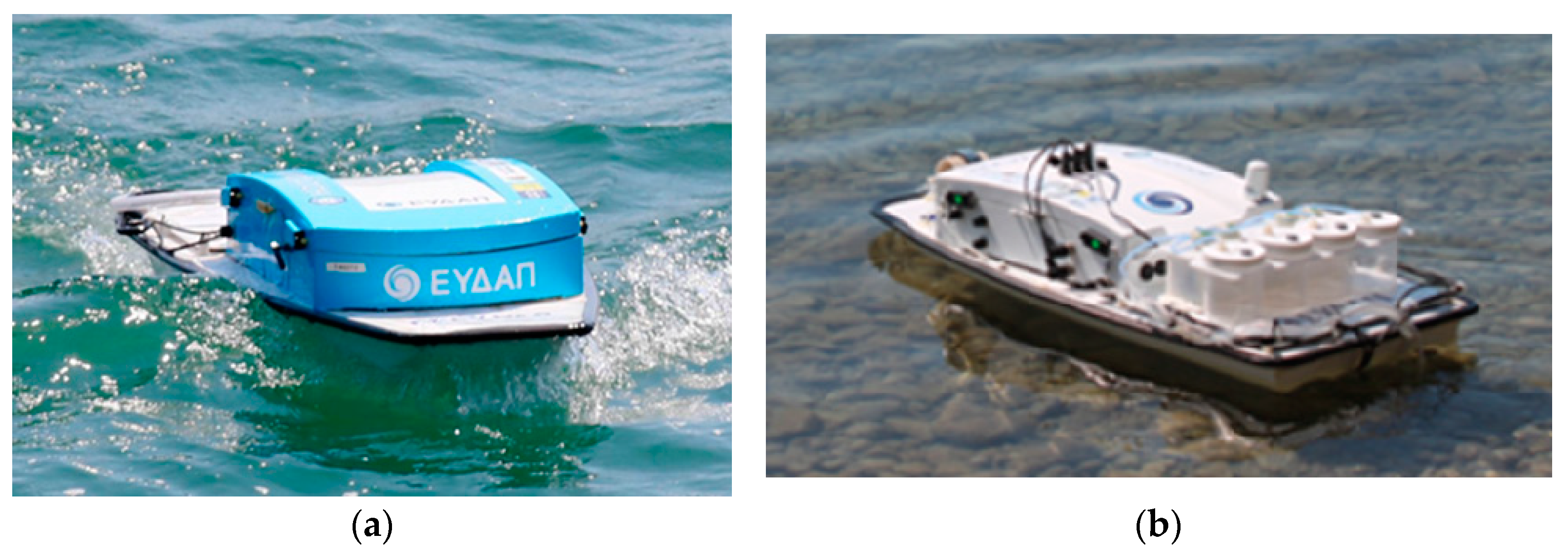
Figure 3.
Study areas in Greece with the use of USVs.
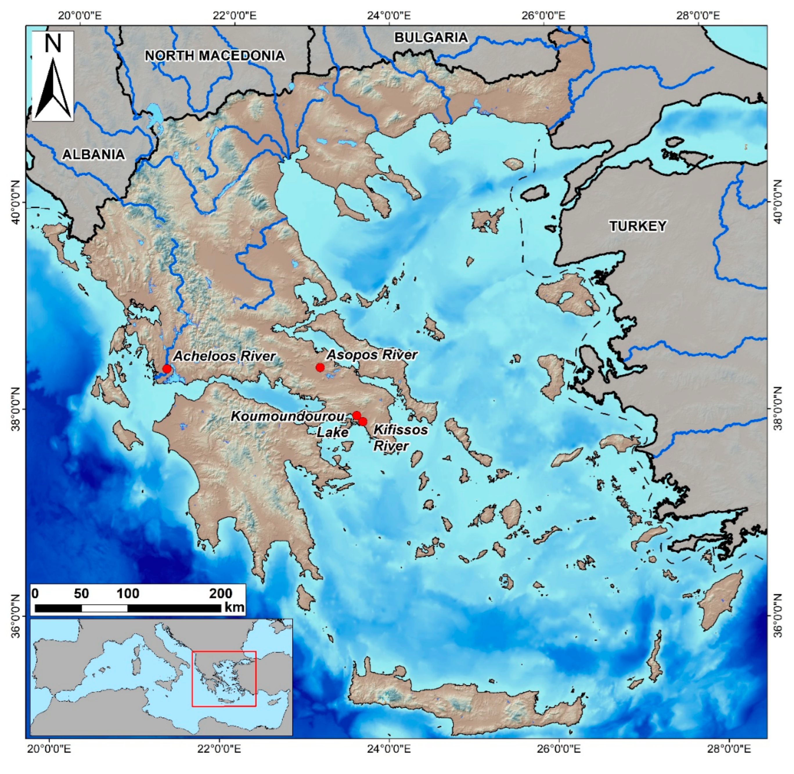
Figure 5.
Conductivity by the Waquin application of INTCATCH in (a) Koumoundourou Lake, (b) Kifissos river and (c) Acheloos river.
Figure 5.
Conductivity by the Waquin application of INTCATCH in (a) Koumoundourou Lake, (b) Kifissos river and (c) Acheloos river.
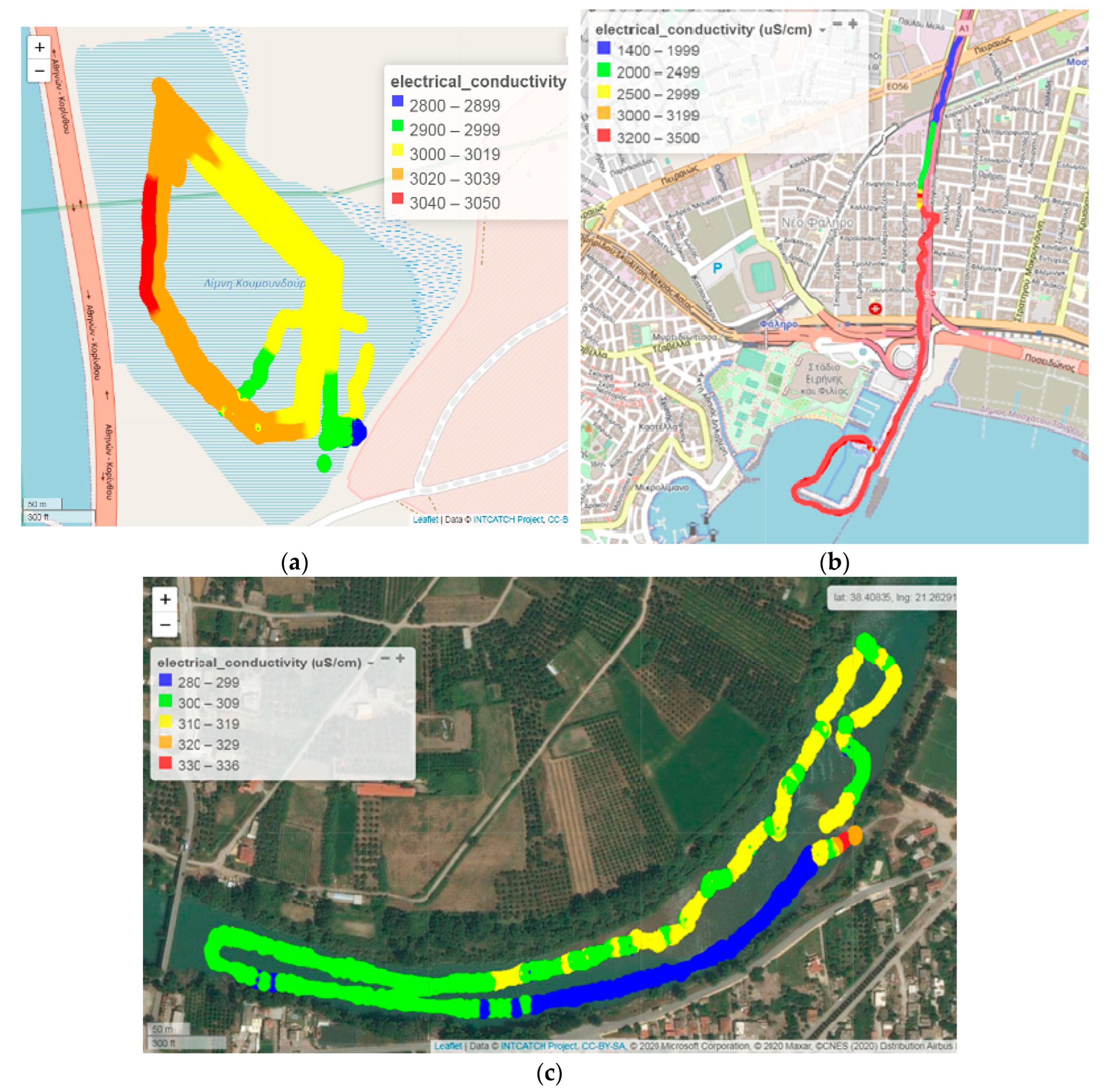
Figure 6.
Dissolved Oxygen by the Waquin application of INTCATCH in (a) Koumoundourou Lake, (b) Acheloos river.
Figure 6.
Dissolved Oxygen by the Waquin application of INTCATCH in (a) Koumoundourou Lake, (b) Acheloos river.

Figure 7.
pH by the Waquin application of INTCATCH in (a) Koumoundourou Lake, (b) Kifissos river.
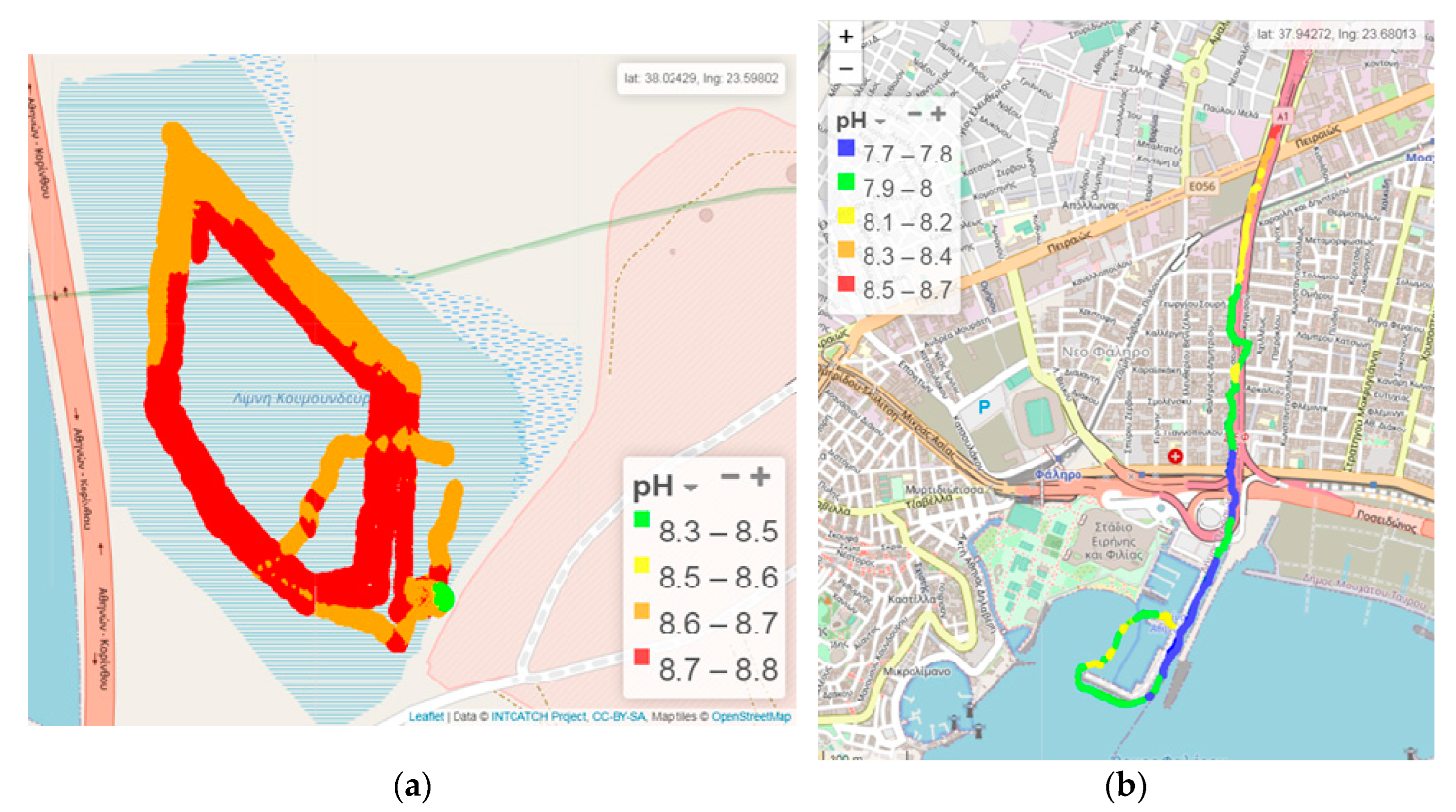
Figure 8.
Calibration Curves for PbL and CuL, Asopos river, 11/10/2019.
Disclaimer/Publisher’s Note: The statements, opinions and data contained in all publications are solely those of the individual author(s) and contributor(s) and not of MDPI and/or the editor(s). MDPI and/or the editor(s) disclaim responsibility for any injury to people or property resulting from any ideas, methods, instructions or products referred to in the content. |
© 2024 by the authors. Licensee MDPI, Basel, Switzerland. This article is an open access article distributed under the terms and conditions of the Creative Commons Attribution (CC BY) license (http://creativecommons.org/licenses/by/4.0/).
Copyright: This open access article is published under a Creative Commons CC BY 4.0 license, which permit the free download, distribution, and reuse, provided that the author and preprint are cited in any reuse.


