
Submitted:
30 January 2024
Posted:
31 January 2024
You are already at the latest version
Abstract
The variety of risks due to climate change with a potential impact on Cultural Heritage CH requires a multidisciplinary approach and a preliminary overview of the existing methods for risk analysis and assessment in different fields. Thus, the starting point of the research conducted by the Sapienza PNRR working group consists in a systematic literature review of risk assessment approaches, methods and indicators. As a first outcome, the research has designed a multidisciplinary comprehensive framework consisting of the definition of risk categorization, the framework represented by a measurable index and the main target, according to the classification of Cultural Heritage based on the harmonization of European vocabularies definitions and protocols. The risk assessment framework sets the methodological core of a future multi criteria matrix and digital platform for decision focused on the historic built environment and it is functional to the definition of specific operational guidelines connected to each risk for elaborating descriptive/predictive Architectural Heritage’s transformation scenarios to support the development of mitigation and adaptation strategies.
Keywords:
cultural heritage
; historic built environment
; risk analysis
; data-driven processes
; multi-risk assessment
1. Introduction
Cultural Heritage (CH) is a vector of social and economic improvement. The composite ecosystem of their tangible and intangible components, made up of rituals and practices along with hand-craft products, buildings and natural elements, offers the opportunity to develop innovative forms of rural, creative and slow tourism experiences, pushing toward a positive job creation trend. However, the current Climate Change (CC) process puts at risk the fragile equilibrium that interlinks natural and human environments in CH. Long-term changes in weather patterns and temperatures, known as CC, are considered one of the most serious threats of the twenty-first century [1]. This natural process, which has been occurring for millions of years due to variations in the solar cycle, has been accelerated in the last two centuries as a result of excessive anthropization and greenhouse gas concentration, upsetting the natural balance and increasing global surface temperature [2]. Every decade since the 1980s has experienced rising temperatures, with the 2011-2020 period being the hottest on record, reaching in 2019 a global average temperature 1.1°C higher than pre-industrial levels [3]. These phenomena emerge as an increase in the frequency and intensity of extreme weather events such as heat waves, droughts, and heavy rains, increasing the risks for ecosystems (1). To mitigate the severe impacts of CC, all sectors of society must collaborate, mobilizing all fields, including education, research, and innovation, and openly encouraging shared responsibility for action [4]. According to the UNESCO Climate Action Policy Paper, CC has become one of the most significant threats to natural and cultural World Heritage sites, with the potential impact on their Outstanding Universal Value (OUV), including their authenticity, integrity, and capacity for economic and social development at the local level, as well as the quality of life of communities linked to World Heritage sites [5]. If sites are not adequately prepared or radical climate actions are not taken at the international, national, and local level, World Heritage sites may be irremediably damaged by extreme weather events [6]. As a result, ICOMOS, a UNESCO advisory body, emphasizes the importance of adequately responding to, and preparing for, CC risks for Cultural Heritage (CH). It highlights the need for effective conservation, use, and management of tangible and intangible cultural resources, considering heritage as a source of resilience and climate mitigation [7]. Not only climate change, the OUV of CH is put at risk by anthropic action which manifests itself in a series of direct and indirect actions capable of altering the ecosystem in which the protected asset is located. Anthropic risks represent a further level of complexity in the evaluation of prevention and mitigation strategies as the evaluation of specific risks is in most cases qualitative and not quantitative. The variety of risks with a potential impact on CH and in particular on Architectural Heritage requires a multidisciplinary approach and a preliminary overview of the existing methods for risk analysis and assessment in different fields. CH is permanently exposed to natural and anthropic hazards due to the impact of climate change, which accelerates the effects of natural hazards as well as those caused by human actions [8]. The traditional distinction between natural and anthropic hazards is challenged by the combination and interaction of different hazards and causes, as natural disasters also cause migration and social conflicts, and human behavior accelerates natural processes. Phenomena related to climate change and natural/anthropic risks raise new research questions and open new challenges for modern societies, requiring a broad multidisciplinary approach towards problem solving. A multi-scale approach should be applied to encompass different scenarios and to address both general and specific issues. Overall objective of the PNRR Research Project (2) is delivering innovative solutions to mitigate the effects of climate change, natural and anthropic risks on cultural heritage, based on the following methodological steps:
- identification of knowledge gaps and development of an appropriate shared paradigm (new concepts) and coordination of data acquisition and integration;
- evaluation of resilience and adaptation models of the past, re-appropriation of historical memory;
- comprehensive risk analysis on the multivariate effect of climate change and the interaction of different risks;
- development of a shared framework for modeling, simulation, and computerized data drive monitoring;
- integration of knowledge fields to support the Multi-Criteria Decision Method (MCDM);
- development of an interdisciplinary framework for a Decision Support System (DSS) aimed at the redevelopment and design of architectural heritage and historical landscape.
2. Materials and methods
2.1. Risk assessment process
In the process of risk assessment it is crucial to explore the interconnected dimensions of risk, focusing on the interplay between hazard, vulnerability, and exposure [9]. Hazards, as defined by the Intergovernmental Panel of Climate Change (IPCC), are potential sources of harm, encompassing both natural phenomena and anthropogenic events “that may cause loss of life, injury, or other health impacts, as well as damage and loss to property, infrastructure, livelihoods, service provision, and environmental resources” [10]. The dynamic interaction among hazards, vulnerability, and exposure underscores the complexity of risk, necessitating a holistic approach to mitigate its impacts. Hazards are inherently diverse and dynamic, spanning geological, meteorological, and anthropogenic domains. Natural hazards, driven by Earth's processes, include earthquakes, floods, and wildfires [11], anthropogenic hazards, stemming from human activities, encompass industrial accidents, chemical spills, and pollution [12]. Understanding the frequency, intensity, and spatial distribution of hazards is crucial for effective risk assessment [13]. Vulnerability, as defined by Adger [14], is the susceptibility of a system to harm, influenced by physical, social, economic, and environmental factors. Social vulnerability often arises from disparities in wealth, education, and healthcare access as stated by IPCC while physical vulnerability may result from inadequate infrastructure or inappropriate land use planning. A comprehensive vulnerability assessment is pivotal for identifying risk-prone areas and populations. Exposure refers to the degree to which elements at risk, such as populations, assets, or ecosystems, are subject to a hazard [15] and spatial and temporal dimensions of exposure play a crucial role in determining risk levels. Mapping exposure helps identify high-risk areas, enabling targeted interventions and resource allocation. Thus, risk assessment integrates hazard analysis, vulnerability assessment, and exposure mapping to quantify the likelihood and consequences of adverse events [16]. Effective risk management strategies involve interdisciplinary collaboration, community engagement, and policy interventions that are fundamental to activate early warning systems, build resilient infrastructure and adaptive strategies to reduce overall risk [17]. A nuanced understanding of the interconnected dimensions of risk is imperative for sustainable development and resilience. The United Nations Office for Disaster Risk Reduction (UNDRR) define resilience as: “the ability of a system, community or society exposed to hazards to resist, absorb, accommodate to and recover from the effects of a hazard in a timely and efficient manner, including through the preservation and restoration of its essential basic structures and functions.” [18]. Various methodologies and strategies are employed in the risk assessment processes [19]:
- Quantitative Risk Assessment: this method takes a numerical approach, utilizing hazard scenarios and the valuation of at-risk elements;
- Event Tree Analysis: employing a quantitative perspective, this method involves defining trees to establish relationships between diverse hazards and events;
- Risk Matrix Approach: this approach tackles risk qualitatively, allowing for the categorization of risks based on expert knowledge, particularly in situations where quantitative data is either lacking or limited;
- Indicator-Based Approach: this semi-quantitative method involves the use of indicators associated with each risk determinant or component (such as hazard, exposure, and vulnerability). These indicators are then normalized, weighted, and aggregated to derive a comprehensive risk score.
Most of the methodologies introduced above takes a quantitative approach that requires a clear overview of hazard taxonomy such as indicators, indexes and thresholds.
2.2. Methodological framework for hazards taxonomy identification
Thus, the starting point of the research consists in a systematic literature review of risk assessment approaches, methods and indicators. This process represents the base of a multidisciplinary framework consisting of the definition of risk, its categorization, its metrics represented by a measurable index and its main target, according to the classification of CH based on the harmonization of European vocabularies definitions and protocols. The framework will be also developed as a result of a co-creation process based on the collaboration between professionals and academics. This process, integrating different indicators in a synthetic evaluation model, emphasizes the multidisciplinary and multi-objective nature of the preservation of CH. Overcoming this diversity and thus barriers between disciplines has been a research priority, for which the sharing of expertise and data has been necessary. The methodological framework is defined as follow:
- Analysis of the main International and National risk assessment protocols;
- Definition of the first risk classification based on the two main classes such as natural and anthropic risks;
- Identification of the main hazard components for quantitative or semi-quantitative risks assessment.
The second stage of the research is devoted to risk's taxonomy development through a series of strategies:
- Analysis of EU Research Project completed or underdevelopment;
- Use of AI chatbot;
- Systematic Literature review and co-creation process.
As final outcome a multidisciplinary framework will be developed. The database will allow the quantitative or semi-quantitative assessment of natural and anthropic hazards that will be described taking in consideration indicators, indexes and threshold.
2.3. Hazard analysis and taxonomy
To establish a comprehensive understanding of research on hazards, the research gathered data from European and national Agencies, identified the most pertinent and comprehensive reports related to the analyzed topic, and assessed relevant online platforms for task development. Nevertheless, the in-depth overview of risk analysis at both national and European levels relies also on the findings from ongoing and completed EU projects as well as scientific publications. Presented below are the primary selections that contribute to the Task's perspective.
- 3 International references with specific focus on CH and risk assessment:Table 1. International references with specific focus on CH and risk assessment.
UNESCO World Heritage Convention https://whc.unesco.org/en/factors/ International Centre for the Study of the Preservation and Restoration of Cultural Property ICCROM https://www.iccrom.org/publication/guide-risk-management ICOMOS – ICORP
International Scientific Committee on Risk Preparednesshttps://icorp.icomos.org/

- 2 International references on risk assessment:Table 2. International references on risk assessment.
DRMKC - Disaster Risk Management Knowledge Centre https://drmkc.jrc.ec.europa.eu/risk-data-hub/#/ UN Office for Disaster Risk Reduction https://www.undrr.org/implementing-sendai-framework
- 3 National references on risk assessment:Table 3. National references on risk assessment.
Department of Civil Protection
Presidency of the Council of Ministershttps://www.protezionecivile.gov.it/it/ ISPRA - ISTITUTO SUPERIORE per LA PROTEZIONE E LA RICERCA AMBIENTALE https://www.isprambiente.gov.it/it INGV - ISTITUTO NAZIONALE
GEO-VULCANOLOGIAhttps://www.ingv.it/
The analysis of the main national and international protocols on risk identification was carried out on both a general and specific level for the cultural heritage in order to identify risk clusters that may be considered invariant. During the first phase, the investigation was aimed at defining the risk class – natural, anthropic, and anthropic/natural – of the corresponding type and of the specific risk in relation to the different identified classes.
The database’s structure was articulated as follows:
- Risk class;
- Risk type;
- Specific risk;
- Probability classes (in the event of qualitative assessment);
- Indicators;
- Indices;
- Metrics (in the event of quantitative assessment);
- Bibliographical references and sources.
- Glossary.
The first protocol analyzed, the UNESCO World Heritage Convention, proposes a comprehensive classification of primary and secondary risk factors that can have a negative influence on the conservation of the “Outstanding Universal Value” (OUV), in terms of the historical, artistic, scientific, aesthetic, ethnological, or anthropological level of the world cultural heritage. The primary risk factors were defined by establishing a broad spectrum of application in a variety of natural, anthropic, and historical/cultural settings. The latter were summarized in thirteen distinct classifications within the framework, with the possibility of including others if the supplied risk is not comprehensive or if further risk elements yet to be identified should arise.
The primary factors identified at the present time are the following: Buildings and Development, Transportation and Infrastructure, Utilities and Service Infrastructure, Pollution, Biological Resource Use/Modification, Physical Resource Extraction, Local conditions affecting physical fabric, Social/cultural uses of heritage, Other human activities, Climate change and severe weather events, Sudden ecological or geological events, Invasive/alien species or hyper-abundant species, and Management and institutional factors. Although the primary factors are not classified as natural, anthropic, and anthropic/natural risks, the description of the secondary factors allows the classification within the framework to be easily refined.
Based on the identified primary and secondary factors, UNESCO proposes a list of 56 protected assets that are potentially at risk, with the consequent loss of OUV, providing a purely qualitative description of the phenomenon.
As relates to the cultural heritage, an additional classification of potential risk factors is provided by the International Centre for the Study of the Preservation and Restoration of Cultural Property, ICCROM. The protocol defines a hierarchy of elements that work together to identify the specific risks. The analysis starts from the context within which the cultural heritage, be it a building, a monument, a project, or a scenic site, is placed, identifying a series of factors that can contribute towards determining the risks, identifying them, and managing them. These include environmental, political, sociocultural, administrative financial, and legal aspects, as well as potential stakeholders. The context analysis phase is preparatory for identifying the risks, which calls for defining:
- Ten agents of decay;
- Six layers of “enclosure;
- Three risk categories in relation to their likelihood of occurrence.
Agents of decay are factors that can cause damage and therefore result in loss of value of the asset being analyzed in a specific place and in a given setting. The ten identified agents are: Physical forces, Dissociation, Incorrect RH, Incorrect temperature, Light and UV, Pollutants, Pests, Water, Fire, and Criminals. For each of these, the protocol provides specific, multi-scale examples on possible risk sources and the potential damage they can cause to the cultural heritage. In this regard, Physical Forces include as risk sources extreme events like earthquakes, wind, and erosion, as well as the improper handling of artistic assets, while the possible effects include the structures’ collapse, damage, and abrasion of their surfaces. The illustration of the agents of decay is accompanied by concrete examples that help clearly identify their cause and their effects upon the cultural heritage. To contribute towards identifying the potential hazards, the concept of “Layers of Enclosure” is introduced, through which the architectural heritage being studied is placed in relation with the corresponding ecosystem that may be considered as a potential source of damage and as an element of protection from it. If the object for which a risk analysis is performed is an archaeological find, its “Layer of Enclosure” will be the museum display case, or the container in which it is conserved, while the ecosystem with which it will relate will be the room in which it is placed. Following a bottom-up logic, the layers are defined as follows: Support, Fitting, Room, Building, Site, Region.
The final component of the analysis is the assessment of the likelihood that the risk will occur. The protocol proposes three categories:
- Rare events that take place once every 100 years (e.g. floods, earthquakes, and destructive fires);
- Common events that take place several times over the course of 100 years (e.g. earthquakes and fires of low/medium intensity);
- Cumulative processes that can take place continuously or intermittently (e.g. corrosion of metals, erosion of stone).
An additional general and trans-scalar reading on the risks is provided by two international agencies: DRMKC - Disaster Risk Management Knowledge Centre and UN – Office for Disaster Risk Reduction. The former offers a classification of the risks based on eight classes, each of which presenting risk types and specific risks. The identified classes are as follows: Geophysical, Hydrological, Meteorological, and Climatological, as natural risks, Technological and Transportation for anthropic ones, and Biological as events born from the interaction between natural and anthropic phenomena. To support the analysis, the protocol offers a “digital vocabulary” based on ShowVoc datasets, aimed at outlining the taxonomy of the risk, while identifying its main components.
The database is structured as follows:
- Risk class;
- Risk type;
- Specific risk;
- Description of the risk;
- Metrics (in the event of quantitative assessment);
- Bibliographical references and sources.
The instrument came into being with the intent to organize the base of existing knowledge in a complete taxonomy. This taxonomy aims to cover not only the components of the risk (potential damage, exposure, and vulnerability/resilience), but also the management processes and phases (for example, risk assessment and inventory of data on losses due to catastrophes). An additional tool offered to support the analysis of the risk in all its components, damage, exposure, and vulnerability, is the RISK DATA HUB through which a WEB GIS application allows the potential damage of a particular asset (building, population, economy) for a geographical area to be displayed, taking a specific risk into consideration from time to time.
Lastly, on the international level, consideration was also made of the UN - Office for Disaster Risk Reduction classification that is articulated in clusters based on seven risk classes: Meteorological and Hydrological, Geohazard, Environmental, Chemical, Biological, Technological, and Societal. Each class has different risk types corresponding to the specific risks. Supporting the classification is a webpage with a “Knowledge Base” section where the taxonomy of the risks, hazard, exposure, and vulnerability may be examined in greater depth, with content updated daily.
On the national level, as an initial instrument, that of the Department of Civil Protection, Presidency of the Council of Ministers was analyzed, which provides a holistic vision of the issue of risks, identifying nine types of risk: Seismic, Meteo/Hydrological, Volcanic, Seaquake, Forest fires, Health, Environmental, Nuclear, and Industrial. For these, a purely qualitative description of the phenomenon is provided with reference to the national risk prevention Plan and the risk prevention strategies. No indications are provided as to the risk classes and the specific risks. A broader discussion is referred to such national agencies as ISPRA – Istituto Superiore per la Protezione e la Ricerca Ambientale – and INGV – Istituto Nazionale GEO-VULCANOLOGIA – as concerns discussion of the specific risks set in relation to hydrogeological and seismic events. In this case, the description of the specific risk is broadened with indices, indicators (where present), and metrics.
Most of the analyzed protocols, except for the DRMKC, provide no classification of the risks based on the definition of the class, type, and specific risk. The DRMKC provides a “digital vocabulary” for which a clear taxonomy of the risks is outlined that facilitates understanding of these risks, also for users with no specialistic know-how. The tool also provides metrics for the quantitative assessment of the risks even if, in many cases, the datum is no longer available. In no case is information provided for indices and indicators of the specific risks.
The analysis of the general classification proposed by the main national and international protocols was preparatory for the definition of the two main risk classes, natural and anthropic, and for the selection of the various types of risk to be associated with the respective classes within the comprehensive research framework.
First, an initial partial clusterization of the risks was performed by analyzing the results in progress of the European 4CH Project (2021-2024) (3). 4CH provides a general classification of the risks based on the two main macro areas of natural and anthropic risks. As concerns natural phenomena, an additional classification was done for risks derived from cumulative processes, which is to say all the forms of deterioration that gradually accumulate over time, or any process or intermittent and fluctuating event that takes place more than once a year, and risks due to catastrophic events that are often beyond human control. The risks belonging to the first sub-category (cumulative processes) are classified as natural and biological. The former comprise the following types of risk: see level rise, glaciation, erosion, silting, desertification, ground-water, deposition, and vibration. The biological ones comprise: animal migration, vegetation, pest, decay and degradation. For the second sub-category, the classification proposed in the context of the 4CH Project is as follows: invasive species and extreme climate and geological events. The risk types underlying the invasive species include fauna and flora, while the extreme climate events are fire, downpours, squalls, floods, and hail. To conclude, extreme geological events are tsunami, earthquake, landslide, and volcano. For the anthropic class, a subdivision is proposed based on intentionality: intentional and indirect risks of causing damage to the cultural heritage. The intentional risks are in turn classified between management and crimes against the cultural heritage. As concerns the former, we find the following risk types: modern re-use, corruption, quarrying, and political; and, in the latter, vandalism, arson, theft, illegal excavations, illicit trafficking, and collectors. The family of indirect anthropic risks comprises: building/infrastructure/industry, land conversion, Heritage management, Socio-cultural, and other. Building/infrastructure/industry comprises: industrial activity, constructions, transportation, pollution, and mining. In land conversion: agriculture and forestation; Heritage management: negligence, neglect, restoration, tourism industry, visitors, and handling; Socio-cultural: change in value, veneration, loss of traditional knowledge, and performance.
Through the analysis of the deliverables dedicated to the mapping of the risks and to the development of the case studies, the types belonging to the natural and anthropic risks could be identified, for which to complete the taxonomy by providing the missing information relating to indices, indicators, and metrics of use for the purpose of the quantitative assessment of the risks. The classification proposed by the 4CH project was implemented with respect to the one proposed by the main international protocols that are the object of study, and in relation to the specific research purposes. In particular, the final classification is configured as the result of the following operations:
- homologation to the taxonomy used in the 4CH project with reference to the main international classifications;
- implementation of the natural risk types closely correlated with climate change (e.g. heat wave e cold wave);
- introduction of risk types resulting from interaction between natural and anthropic phenomena that can impact the conservation protection of the CH;
- specific classification of certain risk types that make reference to generic phenomena (e.g. Pollution, Flood);
- selection of anthropic risks in relation to the specific purposes of the research.
The following is the classification that was developed (Table 4):
Having completed the classification and identified the risk types, the second phase of the research related to the definition, if possible, of the associated specific risks, the probability classes, the indicators, the indices, and the metrics (Table 5) of use for the purpose of the quantitative or semi-quantitative assessment of the risk in relation to the cultural heritage.
In order to complete the taxonomy and provide a framework that is as comprehensive as possible, the work proceeded as follows:
- Assessment of the Projects financed by the EU framework programmes concluded or in the completion phase, considering the timeframe of the past ten 10 years, 2013-2023;
- Use of Artificial Intelligence AI, chatbot;
- Literature review and co-creation of the database with the support of specialists in the sector;
- Analysis of reports of national and international agencies specialized in managing and assessing specific risks (e.g. The World Meteorological Organization);
- Consultation of specific databases on the taxonomy of risks.
2.4. Selection of European Project on CH multi-risk assessment
Analysis of some of the main European projects on the topic was done using CORDIS, Community Research and Development Information Service, a database that collects the results of the Projects financed by the EU framework programmes for research and innovation (from FP1 to H 2020). A set of keywords was used to scan the database in relation to the specific purpose of the research, considering the timeframe of the past ten 10 years (2013 to 2023). The analysis was immediately restricted to the projects with multi-risk analysis and assessment processes. An additional investigation was done on the INTERREG CENTRAL EUROPE platform which has a database of projects financed by the specific EU 2014-2020 fund, subdivided into four categories: INNOVATION, LOW-CARBON, ENVIRONMENT/CULTURE, TRANSPORT. The screening focused on the ENVIRONMENT/CULTURE category. Within this category, the choice was made to more deeply analyze two projects which, by analyzing the Deliverables, made it possible to obtain elements of use for further refining the risk taxonomy.
The first of these projects is ProteCHt2save (2016-2019) (Table 6). In particular, the main focus of the research pertaining to the mitigation of the natural risks derived from CC, and in particular the floods and fires derived from periods of serious drought, was analyzed with the intent to preserve CH through a multi-scale approach, from the artefact to the landscape, using tailor-made solutions marked by relative simplicity of application. Analysis of the deliverables made it possible to track a partial classification of the natural risks derived from CC with some indices and indicators of use for the purpose of a quantitative assessment of the associated risks.
Other data for the completion of the framework were extrapolated from the Strench (2020-2022) project, using the associated digital platform. The portal provides a list of natural risks derived from CC, such as: heavy rain, flood, drought, and extreme heat. Moreover, some climate variables are defined, like minimum temperature, maximum temperature, and precipitation, which may be considered as determinant factors in the definition of the risks. For the specific risks cited above, various indices and indicators of use for the quantitative and semi-quantitative assessment are reported, in addition to a description to facilitate understanding of the associated phenomenon (Table 7).
In the context of the Projects financed by the EU framework programmes, Prothego - PROTection of European Cultural HEritage from GeO-hazards (H2020, 2015-2018) (Table 8) deals with the issue of protection from CH with respect to the risks derived from such geomorphological events as landslides, earthquakes, and phenomena associated with volcanic activity. Analysis of the project’s deliverables allowed partial data on the taxonomy of geomorphological risks, like threshold values and indicators for a qualitative or semi-quantitative assessment, to be collected. No indices are present.
An additional research of the potential natural risks derived from CC that may affect CH is performed in the setting of the Heracles Project (H2020, 2016-2019). Analysis of the deliverables made it possible to identify the specific risks selected for the qualitative assessment. It was not possible to arrive at the indicators and indices used for the quantitative assessment of the risks (Table 9).
The work undertaken in the STORM project (H2020, 2016-2019) underlies the development of decision-making tools aimed at facilitating the preservation of CH in the face of the challenges raised by climate change. Analysis of the deliverables made it possible to achieve the taxonomy of the main natural risks associated with climate change, with clear indication of indices and indicators (Table 10).
The RESIN project (H2020, 2015-2018) studies standardized procedures to assess the vulnerability of CH, evaluating the effectiveness of adaptation and mitigation measures. These procedures serve as a guide for decisions and the creation of mitigation strategies. For the purpose of the assessment, 31 natural risks were selected, and for 18 of them the indices and indicators for a quantitative assessment are reported (Table 12).
A holistic vision based on a data-driven process regarding the impact of the natural risks associated with climate change on the cultural heritage is provided by the European SHELTER Project (H2020, 2019-2023). Analysis of the deliverables and milestones yields a clear classification of the natural risks, developed through dedicated analysis summary sheets where essential information can be retrieved for outlining the damage component associated with the following risk types: Geophysical, Meteorological, Climatological, and Hydrological. For the following types, the main biophysical and climatic factors that may be considered as “determinant,” and the specific, derived risks, are identified. Completing the analysis are summary sheets for each risk that cast light on the following: risk type and class; possible receivers or exposed asset; analysis scale; timeframe (forecast); threshold value with respect to which the potential risk is to be determined (Table 13).
Analysis of these projects described above and of others among the major financed European Projects taken into consideration (15 in all) shows how the setting of the risks associated with natural phenomena, for the most part linked to climate change, is the one most investigated, and for which there is a solid classification of the risks and a complete description of the associated phenomena, in both qualitative and quantitative terms. For the latter, the taxonomy relating to indicators and indices described above were employed as a starting point for developing the framework. Lastly, in light of the investigation that was performed, there are no financed projects aimed at more deeply analyzing the anthropic risks associated with CH, also as pertains to natural risks, in order to asses possible interactions between the two components.
2.5. Artificial Intelligence as research assistant: using chatbot
To complete the framework’s taxonomy, use was made of Artificial Intelligence (AI) tools, particularly CHATGPT 3.5, OPENAI chatbot, an automatic learning model that uses deep learning techniques to generate a text [REFERENCE]. These machines are trained by human beings and by other machines using an enormous dataset updated to 2022. In order to determine indicators, indices, and metrics of the specific risks belonging to the two risk classes (natural and anthropic), the following queries were submitted to the chatbot:
- “(SPECIFIC RISK) indices and metrics”;
- “Can you specify the unity of measure of indices?”
- “(SPECIFIC RISK) indices and metrics scientific references”.
The following is a research example on a specific risk based on the queries (Table 14):
Although the operation is handy in methods and timing, three actions are needed to verify the scientific reliability of the results:
- Analysis of indicators, indices, and metrics provided by the chatbot through a comparison with specific scientific publications and with data contained in European Projects that have been concluded or are in their performance phase;
- Verification of the references provided by the chatbot on specific databases (e.g. Scopus);
- Selection of risk indicators and indices, excluding those that refer to exposure to vulnerability.
The verification of the references provided by the chatbot that was conducted in the experiment confirmed their reliability with respect to the topic discussed, but also highlighted many possibilities for use and many problems yet to be resolved. In particular, it is emphasized that this latter phase makes the methodology unsuitable for searching the parameters being studied, given the vastness of the identified specific risks. Therefore, the use of this tool is still to be confined to the preliminary research phase in order to restrict the field of investigation especially as relates to the types of risks that refer to the anthropic risks class. An additional innovation and possibility is outlined by ChatGPT 4’s version 4 Turbo, in which a specific chatbot can be created, able to develop and analyze a set of scientific publications in order to provide specific data required by the user. This operation might facilitate the research by considerably reducing the time dedicated to literature review.
2.6. Report analysis and co-creation through expert-based knowledge
An additional tool used to compile the database was that of seeking the parameters that describe the specific risks in reports of national and international Agencies and through the consultation of industry experts able to provide expert-based knowledge on given specific risks. Consulting the reports of International Agencies made it possible to complete or implement the taxonomy of the following specific risks:
A multidisciplinary and opensource framework having been prepared, certain risks were defined thanks to a process of co-creation exploiting the expert-based knowledge of the Sapienza University of Rome research unit composed of researchers from various disciplinary sectors. Through the co-creation process, the taxonomy of the following risks was defined:
2.7. Systematic literature review (SLR)
The SLR process was adopted, within the setting of this research, above all to identify the components missing within the framework relating to the natural and anthropic risks (Table 15) of use for a semi-quantitative and quantitative assessment and, in the absence of these, for identifying the methodologies and criteria employed in the assessment processes. In particular, work was done with respect to two research queries (RQs):
- ₋ (RQ1) Are there indexes and metrics to be applied to anthropic or natural risks for quantitative assessment?
- ₋ (RQ2) What criteria (indicators) these research articles employ for anthropic risks assessment?
In relation to the research queries, the SLR process followed these steps:
- ₋ Determining the keywords for building an effective research string in which the first term relates to the “Risk assessment” and the second term relates to the specific risk, e.g. “Air Pollution,” or, conversely, while a possible third term, as well as synonyms, might be employed to reduce the research field by identifying their specific setting, e.g. “Cultural Heritage,” “Indicators and indices,” and “Hazard modelling";
- ₋ Defining the list of inclusion and exclusion criteria. (Table 16);
- ₋ Selecting and analyzing the relevant research.
In order to select the database most efficient for the purposes of the research, three of the leading web search engines were compared (Figure 1):
- Rome Digital Library System of Sapienza University- SBS (Discovery Sapienza) powered by EBSCO host (https://web.uniroma1.it/sbs/discoverysapienza);
- SCOPUS peer review database (https://www.scopus.com);
- GOOGLE SCHOOLAR free Web search engine that specifically searches scholarly literature and academic resources (https://scholar.google.com/).
For the research in question, the decision was made to exclude the use of Google Scholar, as it has no peer review filters in the initial phases of the search, and Discovery Sapienza for problems relating to the host and the accesses, privileging the use of SCOPUS (SC). The initial results of the test were obtained by applying the TITLE-ABS-KEY codes to all the “query string” fields. The SC database does not automatically detect the duplicated elements. Starting from the initial query, the research was conducted for each specific risk indicated in the table (Table 12). Due to the specific nature of each of the risks and in order to achieve the best results, the initial query was modified (again within the search field) by changing the order of its terms or eliminating some of them until obtaining the query suitable to yield the results (Figure 2 and Figure 3).
The selection was further restricted by applying the “Study Area” filter on SC in order to refine the research by excluding those disciplinary areas that lie outside the research setting. The selected studies, divided into folders for each specific risk, were exported into the format (RIS) using the Rayyan online platform (htps://www.rayyan.ai) for the screening. The software in question allows users to analyze each article by displaying the title, abstract, keywords, publisher, and authors to determine the product’s inclusion, exclusion, or uncertainty in order to respond to the research queries.
2.7.1. Water pollution
The SLR process for the anthropic risk relating to Water Pollution employed the following research query (RQ): "Risk assessment" AND “Water pollution” AND “Water Quality Index.” The RQ yielded 88 results as research products within the previously defined inclusion and exclusion criteria (Table 17).
An initial analysis of the articles was carried out using the pertinent abstracts in order to identify the presence of indicators and indices of use for a quantitative or semi-quantitative assessment of the specific risk. As a result of this second phase, 28 papers were selected, with respect to which 6 scientific articles were analyzed in the portion relating to the description and assessment of the risk. The SLR made it possible to define indicators and indices of use for a quantitative assessment of the specific risk Water Pollution [38,43] to be implemented in the prepared framework.
2.7.2. Hail
The SLR process for the natural risk, Severe Weather, relating to Hail, employed the following RQ: "Risk assessment" AND “Hail”. This research yielded 22 results as research products within the previously defined inclusion and exclusion criteria (Table 18).
An initial analysis of the articles was carried out using the pertinent abstracts in order to identify the presence of indicators and indices of use for a quantitative or semi-quantitative assessment of the specific risk. As a result of this second phase, 2 papers were selected, for which an analytic study was done of the part relating to the definition and assessment of the risk. The SLR made it possible to define indicators and indices of use for a quantitative assessment of the specific risk Hail [44,45] to be implemented in the prepared framework.
2.7.3. Coastal erosion
The SLR process for the natural risk, Severe Weather, relating to Coastal Erosion employed the following RQ: "Risk assessment" AND “Coastal erosion”. The RQ yielded 120 results as research products within the previously defined inclusion and exclusion criteria (Table 19).
An initial analysis of the articles was carried out using the pertinent abstracts in order to identify the presence of indicators and indices of use for a quantitative or semi-quantitative assessment of the specific risk. Given the vastness of the results, the keyword “coastal erosion” was employed to carry out a focus on the specific risk. As a result of this additional screening, 7 papers were selected, for which an analytic study was done of the part relating to the definition of the risk. The SLR made it possible to define indicators and indices of use for a quantitative assessment of the specific risk Coastal erosion [46,52] to be implemented in the prepared framework.
2.7.4. Siltation
The SLR process for the natural risk relating to Siltation employed the following RQ: "Risk assessment" AND “Siltation”. The RQ yielded 12 results as research products within the previously defined inclusion and exclusion criteria (Table 20)
An initial analysis of the articles was carried out using the pertinent abstracts in order to identify the presence of indicators and indices of use for a quantitative or semi-quantitative assessment of the specific risk. As a result of this additional screening, 4 papers were selected, for which an analytic study was done of the part relating to the definition of the risk. The SLR made it possible to define indicators and indices of use for a quantitative assessment of the specific risk Siltation [53,56] to be implemented in the prepared framework.
2.7.5. Frost ground
The SLR process for the natural risk relating to the Frost phenomenon employed the following RQ "Risk assessment" AND “Frost,” which yielded 74 results as research products within the previously defined inclusion and exclusion criteria (Table 21).
An initial analysis of the articles was carried out using the pertinent abstracts in order to identify the presence of indicators and indices of use for a quantitative or semi-quantitative assessment of the specific risk. As a result of this additional screening, 14 papers were selected, for which an analytic study was done of the part relating to the definition of the risk. The SLR made it possible to define indicators and indices of use for a quantitative assessment of the specific risk Frost [57,69] to be implemented in the prepared framework.
2.7.6. Sea level rise
The SLR process for the natural risk relating to the phenomenon Sea level rise employed the following RQ: "Risk assessment" AND “Sea level rise”. This research yielded 449 results as research products within the previously defined inclusion and exclusion criteria. To perform an additional screening of the results, an additional keyword, “Index”, was used, for which 48 scientific products were obtained (Table 22).
An initial analysis was performed using the pertinent abstracts in order to identify the presence of indicators and indices of use for a quantitative or semi-quantitative assessment of the specific risk. As a result of this additional screening, 7 papers were selected, for which an analytic study was done of the part relating to the definition of the risk. The SLR made it possible to define indicators and indices of use for a quantitative assessment of the specific risk Sea level rise [70,77] to be implemented in the prepared framework.
2.7.7. Mining
The SLR process for the natural risk relating to the phenomenon del Mining employed the following RQ: "Risk assessment" AND “Mining hazard”. The RQ yielded 11 results as research products within the previously defined inclusion and exclusion criteria (Table 23).
An initial analysis was performed using the pertinent abstracts in order to identify the presence of indicators and indices of use for a quantitative or semi-quantitative assessment of the specific risk. As a result of this additional screening, 2 papers were selected, for which an analytic study was done of the part relating to the definition of the risk. The SLR made it possible to define indicators and indices of use for a quantitative assessment of the specific risk Mining [78,79] to be implemented in the prepared framework.
2.7.8. Deforestation/land conversion
The SLR process for the natural risk relating to the phenomenon del Deforestation/land conversion employed the following RQ: “land OR agricultural” AND “expansion” OR “land” AND “cover” OR “use” AND “changes” OR “deforestation” AND “quantitative” AND "risk assessment.” The RQ yielded 56 results as research products within the previously defined inclusion and exclusion criteria (Table 24).
An initial analysis was performed using the following search filters: quantitative, risk, risk assessment, index, indicators, and cultural heritage. As a result of this screening, 27 papers were discarded while for the remaining 19 an analytic study of the portion relating to the definition of the risk was performed an analytic study of the portion relating to the definition of the risk was performed. The SLR made it possible to define indicators and indices of use for a quantitative assessment of the specific risk Deforestation/land conversion [80,98] to be implemented in the prepared framework. Although climate change is indicated as the main cause, the scientific community is increasingly aware of the role played by anthropic pressures on the natural ecosystems. The indicators and indices identified to measure the deforestation risk are linked mainly to the characteristics of the soil and vegetation.
2.7.9. Vandalism
The SLR process for the natural risk relating to the Vandalism phenomenon employed the following RQ: “vandalism” AND “cultural heritage,” which yielded 21 results as research products within the previously defined inclusion and exclusion criteria (Table 25).
An initial screening was performed using the following search filters: quantitative, risk, risk assessment, index, indicators, and cultural heritage. As a result of this screening, 9 papers were discarded while for the remaining 6 an analytic study of the portion relating to the definition of the risk was performed. The SLR made it possible to define indicators and indices of use for a quantitative assessment of the specific risk Vandalism [99,105] to be implemented in the prepared framework. Evidence of the classification of various types of vandalism that can strike the cultural heritage (e.g. graffiti, ideological vandalism) was found. The only code found in the SLR relates to the Security Rating Index (SRI) while many of the indicators can be used to comprehend the level of vulnerability of the cultural heritage in the event of hazard.
2.7.10. Illicit trafficking
The SLR process for the natural risk relating to the Illicit trafficking phenomenon employed the following RQ: "illicit trafficking” AND "cultural heritage". The RQ yielded 23 results as research products within the previously defined inclusion and exclusion criteria (Table 26).
An initial screening was performed using the following search filters: quantitative, risk, risk assessment, index, indicators, and cultural heritage. As a result of this screening, 8 papers were selected, for which an analytic study was done of the part relating to the definition of the risk [106,119]. The SLR made it possible to define indicators to be implemented in the framework of use for measuring the probability that this risk might take place, most of which linked to policies for managing the cultural heritage and to natural and anthropic events (e.g. wars) that influence the management of CH. Analysis of the articles shows a growing sensitivity to the illegal traffic, as demonstrated by recent initiatives by UNESCO or ICOMOS to increase the level of protection against illegal trafficking also through international cooperation policies in order to make the specific legislation uniform. No evidence was found on the use of indices for the purposes of the quantitative assessment of the specific risk.
2.7.11. Corruption
The SLR process for the natural risk relating to the Corruption phenomenon employed the following RQs: “corruption” AND “quantitative” AND “risk assessment,” “corruption” AND "risk assessment," “corruption” AND “quantitative” AND “risk assessment.” The RQs respectively yielded 5, 56, and 14 results as research products within the previously defined inclusion and exclusion criteria (Table 27).
An initial screening was performed using the following search filters: quantitative, risk, risk assessment, index, indicators, and cultural heritage. As a result of this screening, 42 articles relating to the used RQs were excluded while 32 were subject to analysis. The SLR made it possible to define indicators and indices to be implemented in the proposed framework [120,134]. The corruption risk is distinguished into various settings all directly correlated to political instability and to the ideological differences that create religious and political tensions, generating a high degree of instability. The main consequence of corruption in CH is illegal trafficking.
2.7.12. Adaptive reuse
The SLR process for the natural risk relating to the Adaptive reuse phenomenon employed the following RQ: “adaptive reuse” AND “cultural heritage”. The RQ yielded 112 results as research products within the previously defined inclusion and exclusion criteria (Table 28).
An initial screening was performed using the following search filters: quantitative, risk, risk assessment, index, indicators, and cultural heritage, through which 90 articles were excluded. For the 22 selected papers, an analytic study of the portion relating to the definition of the risk was performed. The SLR made it possible to define indicators to be implemented in the framework of use for measuring the probability that this risk might take place, most of which linked to policies for managing the cultural heritage [135,149]. During this period of growing urbanization, CH can play a key role in achieving the goals for sustainable development, as widely recognized by such international institutions as the United Nations (UN), the United Nations Educational, Scientific and Cultural Organization (UNESCO), and the International Council on Monuments and Sites (ICOMOS). On the other hand, the impact of the conservation projects and the reuse of CH can cause it damage and loss of identity. The assessment of the risks related to the reuse projects are indispensable for assessing the projects’ feasibility. No evidence was found on the use of indices for the purposes of the quantitative assessment of the specific risk.
2.7.13. Traditional Knowledge losses
The SLR process for the natural risk relating to the Traditional Knowledge losses phenomenon employed the following RQ: “losses” OR “losing” AND “traditional knowledge” AND “cultural heritage.” The research yielded 15 results as research products within the previously defined inclusion and exclusion criteria (Table 29).
An initial screening was performed using the following search filters: quantitative, risk, risk assessment, index, indicators, and cultural heritage through which 9 articles were excluded. For the 6 selected papers, an analytic study of the portion relating to the definition of the risk was performed. The SLR made it possible to define indicators to be implemented in the framework of use for measuring the probability that this risk might take place [150,155]. Traditional culture is linked to the nature and customs of small communities that have maintained an intimate bond with CH over the years. One of the main risk factors is globalization, which comprises a series of transformations in the economy, in society, and in the use of the territory, and that today, along with the effects of climate change, has led to the loss of a large amount of knowledge connected to the tangible (including buildings and landscapes) and intangible cultural heritage. Indices have been identified to measure the risks of loss of ethnobotanical knowledge in areas of high naturalistic interest.
2.7.14. Political instability
The SLR process for the natural risk relating to the Political instability phenomenon employed the following RQs: “political instability” AND “risk assessment” and “political instability” AND “cultural heritage.” The RQs respectively yielded 31 and 9 research products within the previously defined inclusion and exclusion criteria (Table 30).
An initial screening was performed using the following search filters: quantitative, risk, risk assessment, index, indicators, and cultural heritage through which 24 articles were excluded for the first RQ and 5 for the second. For the selected papers, an analytic study of the portion relating to the definition of the risk was performed. The SLR made it possible to define indicators to be implemented in the framework of use for measuring the probability that this risk might take place [156,163]. Political instability is the origin of such other possible risks as wars, corruption, and vandalism that that can directly strike CH in the form of illegal traffic of assets or destruction in the most extreme cases. Political instability is listed in many articles as one of the main risks for the conservation of CH. No specific indicators to quantitatively measure the specific risk were identified, except for the Energy Security Index (ESI) that is placed in direct correlation with political stability.
2.7.15. War
The SLR process for the natural risk relating to the War phenomenon employed the following RQs: “war” AND “risk assessment” AND “cultural heritage” and “war” AND “quantitative” AND “risk assessment.” The first RQ yielded 6 results within the previously defined inclusion and exclusion criteria while the second one yielded 16 (Table 31).
An initial screening was performed using the following search filters: quantitative, risk, risk assessment, index, indicators, and cultural heritage. The screening process excluded 3 articles from the first query and 9 articles from the second, that could not be correlated with the queries to be searched. For the selected papers, an analytic study of the portion relating to the definition of the risk was performed. The SLR made it possible to define indicators to be implemented in the framework of use for measuring the probability that this risk might take place, while there is no evidence of the use of quantitative indices [164,170]. The analysis shows that war has a devastating impact: on CH, becoming a triggering factor for such other risks as soil and water pollution, on natural ecosystems, on the economy, and on a country’s political stability.
3. Results and discussion
3.1. Opensource framework for driven reasoning in risk assessment
Using the methodology described above made it possible to develop an opensource framework based on a reasoned classification of risks, that presents data relating to indicators, indices, and metrics whose consultation facilitates the quantitative or semi-quantitative assessment of the natural and anthropic risks that may have repercussions on CH, from the architectural heritage to the natural landscape, in a multi-scale dimension. Publicly available datasets were created in this study. This data can be found here: [https://docs.google.com/spreadsheets/d/1bg9UyY8tctCj3eFlao3GGAzHk31tiLhTpfVFSl_3EFs/edit?usp=sharing]. The framework collects, in a single repository, the main natural and anthropic risks, with the related taxonomy, representing right from the beginning an open document implemented over the course of time through knowledge-based expertise that can be consulted by researchers, professionals, and public administrations readying assessments of risks in the CH sector. The proposed model will be implemented with the Exposure and Vulnerability risk components, which characterize the various risks in relation to the applicative context (site-based evaluation process) in order to provide a complete assessment framework. The framework’s structure permits additional specializations in greater thematic depth should it be necessary to update the list of specific risks.
4. Conclusion
The research output is configured as an essential tool for completing the first task of the National Recovery and Resilience Plan (PNRR) research Project that calls for a complete quantitative analysis of the risks on the multivariate effects of climate change and on the interaction of the various risks. The adoption of specific selection and data collection methods, the definition of semantic models (ontologies and vocabularies), and the design of a scalable and interoperable logical infrastructure, are key strategies for the development of an information system that supports the entire knowledge process related to the cultural heritage. These models consider and represent, in a format that can be shared and computed, the distinctive traits, the visible and invisible uses of the past and present, and the risks that the cultural heritage is subject to, with the related impact assessments and forecast scenarios, and material and immaterial values, caused for the territory by their presence. In this direction, the definition and the monitoring and control tests that will be done on the two selected case studies will make it possible to validate the new methods for aggregating and organizing the data and metadata derived from different possible disciplinary paths converging upon the reading of the natural and building historical heritage, holding together the complexity of the processes and visions connected to knowledge of them. The overcoming of the barriers between the disciplines is in fact a priority of the project, which makes it necessary to share knowledge and data in order to achieve processes of sustainable transformation of the heritage, to be implemented through Decision Making (MCDM) opening towards new design scenarios. These planning systems use an evidence-based approach that allows data originating from the various scientific and humanistic sectors involved to be integrated.
Note
(1) The Intergovernmental Panel on Climate Change Sixth Assessment Report (AR6) provides a detailed assessment of the impacts of CC on cities, settlements, and infrastructure, and clearly states that without urgent, effective, and equitable mitigation actions, this phenomenon will increasingly threaten people's well-being and health on a global and regional scale.
(2) Research Project PE05-CHANGES-SPOKE Protection and Conservation of Cultural Heritage against Climate Changes, Natural and Anthropic Risks, Thematic line: n. 3 “Multi-source digital data and metadata related to environment and historic landscape”, P.I. Prof. Alessandra Battisti.
(3) The 4CH project deals with the study of methods, procedures, and tools of use for creating a centre of expertise capable of dialoguing with national cultural institutions, providing support and consulting as concerns the protection of the cultural heritage in relation to natural and anthropic risks.
Supplementary Materials
Appendix 1: Results of SLR on water pollution risk, Appendix 2: Results of SLR on hail risk, Appendix 3: Results of SLR on coastal erosion risk, Appendix 4: Results of SLR on siltation risk, Appendix 5: Results of SLR on frost ground risk, Appendix 6: Results of SLR on sea-level rise risk, Appendix 7: Results of SLR on mining risk, Appendix 8: Results of SLR on deforestation/land conversion risk, Appendix 9: Results of SLR on vandalism risk RQ1, Appendix 10: Results of SLR on vandalism risk RQ2, Appendix 11: Results of SLR on Illicit trafficking risk, Appendix 12: Results of SLR on corruption risk RQ1, Appendix 13: Results of SLR on corruption risk RQ2, Appendix 14: Results of SLR on corruption risk RQ3, Appendix 15: Results of SLR on adaptive reuse risk, Appendix 16: Results of SLR on Traditional Knowledge losses risk, Appendix 17: Results of SLR on political instability risk RQ1, Appendix 18: Results of SLR on political instability risk RQ2, Appendix 18: Results of SLR on war risk.
Author Contributions
Conceptualization, A.B. and A.F.; Methodology, A.B., A.F. and M.L.S..; Investigation, A.F.; Data Curation, A.F.; Writing – Original Draft Preparation, A.F.; Writing – Review & Editing, A.B.; Supervision, A.B. and M.L.S.; Funding Acquisition, A.B and M.L.S.
Funding
This research PE05-CHANGES-SPOKE Protection and Conservation of Cultural Heritage against Climate Changes, Natural and Anthropic Risks was funded by EU European Union Found grant number CUP B53C22003780006.
Data Availability Statement
Publicly available datasets were created in this study. This data can be found here: [https://docs.google.com/spreadsheets/d/1bg9UyY8tctCj3eFlao3GGAzHk31tiLhTpfVFSl_3EFs/edit?usp=sharing].
Acknowledgments
The authors would like to express deepest gratitude to the whole research team of Sapienza University of Rome composed by Mattia Azzella, Herbert Natta, Maria Valese e Alberto Calenzo for partecipating in the co-creation process of the open framework. The authors are also grateful to Eva Vergara for the support on the Systematic Literature Review process.
Conflicts of Interest
The authors declare no conflict of interest.
References
- Mitchell, D.; Heaviside, C.; Vardoulakis, S.; Huntingford, C.; Masato, G.; Guillod, B.P.; Frumhoff, P.; Bowery, A.; Wallom, D.; Allen, M. Attributing human mortality during extreme heat waves to anthropogenic climate change. Environmental Research Letters 2016, 11. [CrossRef]
- EEA: National climate change vulnerability and risk assessments in Europe. Office for Official Publications of the European Union, Luxembourg (2018).
- IPCC: Climate Change 2022: Impacts, Adaptation, and Vulnerability. Contribution of Working Group II to the Sixth Assessment Report of the Intergovernmental Panel on Climate Change. Cambridge University Press, Cambridge (2022).
- UNESCO: Changing minds, not the climate: UNESCO mobilizes to address the climate crisis. United Nations Educational, Scientific and Cultural Organization, Paris (2019).
- UNESCO: Updating of the Policy Document on climate action for World Heritage. In: 23rd Session of the General Assembly of States Parties, Paris (2021).
- UNESCO: Strategy for Action on Climate Change. In: 39th Session General Conference, Paris (2017).
- ICOMOS Climate Change and Heritage Working Group: The future of our pasts. Engaging cultural heritage in climate action. International Council on Monuments and Sites, Paris (2019).
- IPCC: Climate Change 2023: Synthesis Report. A Report of the Intergovernmental Panel on Climate Change. Contribution of Working Groups I, II and III to the Sixth Assessment Report of the Intergovernmental Panel on Climate Change. Cambridge University Press, Cambridge (2023).
- Burton, I.; Kates, R. W.; White, G. F. The environment as hazard, Second Edition, Guilford Press: New York, USA, 1993, ISBN 9780898621594.
- IPCC: Managing the Risks of Extreme Events and Disasters to Advance Climate Change Adaptation. Cambridge University Press, Cambridge (2012).
- UNDRR: Sendai Framework for Disaster Risk Reduction 2015-2030." United Nations Office for Disaster Risk Reduction (2015).
- Turner, B. L.; Kasperson, R. E.; Matson, P. A.; McCarthy, J. J.; Corell, R. W.; Christensen, L.; Schellnhuber, H. J. A framework for vulnerability analysis in sustainability science. In Proceedings of the National Academy of Sciences 2003, 100, pp. 8074-8079.
- Smith, K.; Ward, R.; Day, S. Environmental hazards: Assessing risk and reducing disaster, 7th Edition, Routledge: London , UK, 2023; Part 1 The Nature of Hazard, ISBN 9781351261647.
- Adger, W.N. Vulnerability. Global Environmental Change 2006, 16. [CrossRef]
- Cutter, S. L.; Mitchell J. T.; Scott M. S. Revealing the vulnerability of people and places: A case study of Georgetown county, South Carolina. Annals of the Association of American Geographers 2000, 90. [CrossRef]
- UNEP: Global Environment Outlook (GEO-5): Environment for the future we want. United Nations Environment Programme (2013).
- Smith, K. Environmental Hazards: Assessing Risk and Reducing Disaster, 6th Edition, Routledge: London, UK, 2013, ISBN 9780415681063.
- UNDRR: 2009 UNISDR terminology on disaster risk reduction. United Nations Office for Disaster Risk Reduction (2009).
- Van Westen, C.J. Risk assessment methods. Available online: https://www.cdema.org/virtuallibrary/index.php/charim-hbook/methodology/5-risk-assessment/5-5-risk-assessment-methods (accessed on 21/10/2023).
- World Health Organization. Regional Office for Europe. Health risk assessment of air pollution: general principles. Available online: https://apps.who.int/iris/handle/10665/329677 (accessed on 25/10/2023).
- FAO and UNEP. 2021. Global Assessment of Soil Pollution: Report. Rome. [CrossRef]
- Peeters, P.; Gössling, S.; Klijs, J.; Milano, C.; Novelli, M.; Dijkmans, C.; Eijgelaar, E.; Hartman, S.; Heslinga, J.; Isaac, R.; Mitas, O.; Moretti, S.; Nawijn, J.; Papp, B.; Postma, A. Research for TRAN Committee - Overtourism: impact and possible policy responses, European Parliament: Policy Department for Structural and Cohesion Policies, Brussels, 2018.
- World Meteorological Organization (WMO) and World Health Organization (WHO). Heatwaves and Health: Guidance on Warning-System Development. Available online: https://library.wmo.int/doc_num.php?explnum_id=3371 (accessed on 27/10/2023).
- World Meteorological Organization (WMO). Event Types of Hazards and Extreme Events. Available online:www.wmo.intpages/prog/wcp/wcdmp/meeting/documents/Catalogue_Hazards_Extreme_Events_WMO_091117.pdf (accessed on 03/11/2023).
- Government of Canada. Canadian Forest Fire Weather Index (FWI) System. Available online: https://cwfis.cfs.nrcan.gc.ca/background/summary/fwi (accessed on 05/10/2023).
- EAWS. European Avalanche Warning System. Available online: https://www.avalanches.org/ (accessed on 07/10/2023).
- Copernicus EU. European Flood Awareness System (EFAS). Available online: https://www.efas.eu/en (accessed on 16/09/2023).
- EAWS. European Avalanche Warning System. Available online: https://www.avalanches.org/ (accessed on 07/10/2023).
- European Soil Data Centre (ESDAC). Soil Erosion Risk Assessment in Europe. Available online: https://esdac.jrc.ec.europa.eu/content/soil-erosion-risk-assessment-europe (accessed on 28/09/2023).
- World Meteorological Organization (WMO); Global Water Partnership (GWP). Handbook of Drought Indicators and Indices, Integrated Drought Management Programme (IDMP), Integrated Drought Management Tools and Guidelines Series 2, Geneva, 2016, ISBN 978-92-63-11173.
- Yang, K.-H.; Seo, E.-A.; Tae, S.-H. Carbonation and CO2 Uptake of Concrete. Environmental Impact Assessment Review 2014, 46, 43–52. [CrossRef]
- Houck, J.; Scherer, G.W. Weathering. In Fracture and Failure of Natural Building Stones; Kourkoulis, S.K., Eds.; Springer: Dordrecht, 2006. [CrossRef]
- Yan, L.; Diao, Y.; Gao, K. Analysis of Environmental Factors Affecting the Atmospheric Corrosion Rate of Low-Alloy Steel Using Random Forest-Based Models. Materials 2020, 13. [CrossRef]
- Malaret, F. Exact Calculation of Corrosion Rates by the Weight-Loss Method. Experimental Results 2022, 3. [CrossRef]
- Monaco A.; Carnevali L.; Cerri J.; Tricarico E.; Genovesi, P. Risultati dell’horizon-scanning e proposta per un elenco di specie esotiche invasive di rilevanza nazionale. Rapporto tecnico Life ASAP, 2020.
- European Food Safety Authority. Guidance on quantitative pest risk assessment. Available online: https://www.efsa.europa.eu/en/efsajournal/pub/5350 (accessed on 21/10/2023).
- Afzali, S.F.; Khanamani, A.; Maskooni, E.K.; Berndtsson, R. Quantitative Assessment of Environmental Sensitivity to Desertification Using the Modified Medalus Model in a Semiarid Area. Sustainability (Switzerland) 2021, 13. [CrossRef]
- Onwordi, C.T.; Semako, M.; Izunobi, J.U.; Osifeko, O.L.; Majolagbe, A.O.; Ojekale, A.B. Assessment of the Groundwater Quality, Physicochemical Composition, and Human and Ecological Health Risks in a Coastal Metropolitan: A Case Study of a Residential Estate in Lagos, Nigeria. Environmental Monitoring and Assessment 2022, 194. [CrossRef]
- Mgbenu, C.N.; Egbueri, J.C. The Hydrogeochemical Signatures, Quality Indices and Health Risk Assessment of Water Resources in Umunya District, Southeast Nigeria. Applied Water Science 2019, 9. [CrossRef]
- Sheykhi, V.; Samani, N. Assessment of Water Quality Compartments in Kor River, IRAN. Environmental Monitoring and Assessment 2020, 192. [CrossRef]
- Mishra, A.; Lal, B. Assessment of Groundwater Quality in Ranchi District, Jharkhand, India, Using Water Evaluation Indices and Multivariate Statistics. Environmental Monitoring and Assessment 2023, 195. [CrossRef]
- Zaghloul, G.Y.; El-Sawy, M.A.; Kelany, M.S.; Elgendy, A.R.; Abdel Halim, A.M.; Sabrah, M.M.; El-Din, H.M.E. A Comprehensive Evaluation of Water Quality and Its Potential Health Risks Using Physicochemical Indices in Coastal Areas of the Gulf of Suez, Red Sea. Ocean and Coastal Management 2023, 243. [CrossRef]
- Faseyi, C.A.; Miyittah, M.K.; Sowunmi, A.A.; Yafetto, L. Water Quality and Health Risk Assessments of Illegal Gold Mining-Impacted Estuaries in Ghana. Marine Pollution Bulletin 2022, 185. [CrossRef]
- Childs, S.J.; Schumacher, R.S.; Demuth, J.L. Agricultural Perspectives on Hailstorm Severity, Vulnerability, and Risk Messaging in Eastern Colorado. Weather, Climate, and Society 2020, 12, 897–911. [CrossRef]
- Torralba, V.; Hénin, R.; Cantelli, A.; Scoccimarro, E.; Materia, S.; Manzato, A.; Gualdi, S. Modelling Hail Hazard over Italy with ERA5 Large-Scale Variables. Weather and Climate Extremes 2023, 39. [CrossRef]
- Ferreira, A.M.; Coelho, C.; Narra, P. Coastal Erosion Risk Assessment to Discuss Mitigation Strategies: Barra-Vagueira, Portugal. Natural Hazards 2021, 105, 1069–1107. [CrossRef]
- Merlotto, A.; Bértola, G.R.; Piccolo, M.C. Hazard, Vulnerability and Coastal Erosion Risk Assessment in Necochea Municipality, Buenos Aires Province, Argentina. Journal of Coastal Conservation 2016, 20, 351–362. [CrossRef]
- Gallina, V.; Torresan, S.; Zabeo, A.; Rizzi, J.; Carniel, S.; Sclavo, M.; Pizzol, L.; Marcomini, A.; Critto, A. Assessment of Climate Change Impacts in the North Adriatic Coastal Area. Part II: Consequences for Coastal Erosion Impacts at the Regional Scale. Water (Switzerland) 2019, 11. [CrossRef]
- Tătui, F.; Pîrvan, M.; Popa, M.; Aydogan, B.; Ayat, B.; Görmüș, T.; Korzinin, D.; Văidianu, N.; Vespremeanu-Stroe, A.; Zăinescu, F.; et al. The Black Sea Coastline Erosion: Index-Based Sensitivity Assessment and Management-Related Issues. Ocean and Coastal Management 2019, 182. [CrossRef]
- Aucelli, P.P.C.; Di Paola, G.; Rizzo, A.; Rosskopf, C.M. Present Day and Future Scenarios of Coastal Erosion and Flooding Processes along the Italian Adriatic Coast: The Case of Molise Region. Environmental Earth Sciences 2018, 77. [CrossRef]
- Audère, M.; Robin, M. Assessment of the Vulnerability of Sandy Coasts to Erosion (Short and Medium Term) for Coastal Risk Mapping (Vendée, W France). Ocean and Coastal Management 2021, 201. [CrossRef]
- Pereira, C.; Coelho, C. Mapping Erosion Risk under Different Scenarios of Climate Change for Aveiro Coast, Portugal. Natural Hazards 2013, 69, 1033–1050. [CrossRef]
- Terêncio, D.P.S.; Cortes, R.M.V.; Pacheco, F.A.L.; Moura, J.P.; Fernandes, L.F.S. A Method for Estimating the Risk of Dam Reservoir Silting in Fire-Prone Watersheds: A Study in Douro River, Portugal. Water (Switzerland) 2020, 12. [CrossRef]
- Rossi, L.; Chèvre, N.; Fankhauser, R.; Margot, J.; Curdy, R.; Babut, M.; Barry, D.A. Sediment Contamination Assessment in Urban Areas Based on Total Suspended Solids. Water Research 2013, 47, 339–350. [CrossRef]
- Zhu, L.; Liu, J.; Xu, S.; Xie, Z. Deposition Behavior, Risk Assessment and Source Identification of Heavy Metals in Reservoir Sediments of Northeast China. Ecotoxicology and Environmental Safety 2017, 142, 454–463. [CrossRef]
- Wu, X.; Feng, X.; Fu, B.; Yin, S.; He, C. Managing Erosion and Deposition to Stabilize a Silt-Laden River. Science of the Total Environment 2023, 881. [CrossRef]
- Gobin, A. Weather Related Risks in Belgian Arable Agriculture. Agricultural Systems 2018, 159, 225–236. [CrossRef]
- Vitasse, Y.; Rebetez, M. Unprecedented Risk of Spring Frost Damage in Switzerland and Germany in 2017. Climatic Change 2018, 149, 233–246. [CrossRef]
- Sgubin, G.; Swingedouw, D.; Dayon, G.; García de Cortázar-Atauri, I.; Ollat, N.; Pagé, C.; van Leeuwen, C. The Risk of Tardive Frost Damage in French Vineyards in a Changing Climate. Agricultural and Forest Meteorology 2018, 250–251, 226–242. [CrossRef]
- Gobbett, D.L.; Nidumolu, U.; Crimp, S. Modelling Frost Generates Insights for Managing Risk of Minimum Temperature Extremes. Weather and Climate Extremes 2020, 27. [CrossRef]
- Mandic, M.V.; Vimic, A.V.; RankovicVasic, Z.; Ðurovic, D.; COsic, M.; Sotonica, D.; Nikolic, D.; Ðurdevic, V. Observed Changes in Climate Conditions and Weather-Related Risks in Fruit and Grape Production in Serbia. Atmosphere 2022, 13. [CrossRef]
- Masaki, Y. Future Risk of Frost on Apple Trees in Japan. Climatic Change 2020, 159, 407–422. [CrossRef]
- Reinsdorf, E.; Koch, H.-J. Modeling Crown Temperature of Winter Sugar Beet and Its Application in Risk Assessment for Frost Killing in Central Europe. Agricultural and Forest Meteorology 2013, 182–183, 21–30. [CrossRef]
- Yue, Y.; Zhou, Y.; Wang, J.; Ye, X. Assessing Wheat Frost Risk with the Support of Gis: An Approach Coupling a Growing Season Meteorological Index and a Hybrid Fuzzy Neural Network Model. Sustainability (Switzerland) 2016, 8. [CrossRef]
- Kotikot, S.M.; Onywere, S.M. Application of GIS and Remote Sensing Techniques in Frost Risk Mapping for Mitigating Agricultural Losses in the Aberdare Ecosystem, Kenya. Geocarto International 2015, 30, 104–121. [CrossRef]
- Lou, W.; Zhao, Y.; Huang, X.; Zhu, T.; Yang, M.; Deng, S.; Zhou, Z.; Zhang, Y.; Sun, Q.; Chen, S. Frost Risk Assessment Based on the Frost-Induced Injury Rate of Tea Buds: A Case Study of the Yuezhou Longjing Tea Production Area, China. European Journal of Agronomy 2023, 147. [CrossRef]
- Pulatov, B.; Linderson, M.-L.; Hall, K.; Jönsson, A.M. Modeling Climate Change Impact on Potato Crop Phenology, and Risk of Frost Damage and Heat Stress in Northern Europe. Agricultural and Forest Meteorology 2015, 214–215, 281–292. [CrossRef]
- Svystun, T.; Lundströmer, J.; Berlin, M.; Westin, J.; Jönsson, A.M. Model Analysis of Temperature Impact on the Norway Spruce Provenance Specific Bud Burst and Associated Risk of Frost Damage. Forest Ecology and Management 2021, 493. [CrossRef]
- Chauhan, Y.S.; Anwar, M.R.; Richards, M.F.; Lake, L.; Sadras, V.O.; Luckett, D.J.; Raman, R.; Krosch, S.; Graham, N. Effect of Soil Water on Flowering and Pod-Set in Chickpea: Implications for Modelling and Managing Frost and Heat Stress. Agronomy for Sustainable Development 2023, 43. [CrossRef]
- Beech, N.; Hewer, M.J. A Climate Change Impact Assessment (Ccia) of Key Indicators and Critical Thresholds for Viticulture and Oenology in the Fraser Valley, British Columbia, Canada. Weather, Climate, and Society 2021, 13, 687–705. [CrossRef]
- Kantamaneni, K.; Phillips, M.; Thomas, T.; Jenkins, R. Assessing Coastal Vulnerability: Development of a Combined Physical and Economic Index. Ocean and Coastal Management 2018, 158, 164–175. [CrossRef]
- Mustika Anindita, R.; Susilowati, I.; Muhammad, F. Flood Risk Spatial Index Analysis in the Coastal Pekalongan, Central Java, Indonesia.; 2020; Vol. 202.
- Ghosh, A.; Das, S.; Ghosh, T.; Hazra, S. Risk of Extreme Events in Delta Environment: A Case Study of the Mahanadi Delta. Science of the Total Environment 2019, 664, 713–723. [CrossRef]
- Furlan, E.; Derepasko, D.; Torresan, S.; Pham, H.V.; Fogarin, S.; Critto, A. Ecosystem Services at Risk in Italy from Coastal Inundation under Extreme Sea Level Scenarios up to 2050: A Spatially Resolved Approach Supporting Climate Change Adaptation. Integrated Environmental Assessment and Management 2022, 18, 1564–1577. [CrossRef]
- Nguyen, T.T.X.; Bonetti, J.; Rogers, K.; Woodroffe, C.D. Indicator-Based Assessment of Climate-Change Impacts on Coasts: A Review of Concepts, Methodological Approaches and Vulnerability Indices. Ocean and Coastal Management 2016, 123, 18–43. [CrossRef]
- Rocha, C.; Antunes, C.; Catita, C. Coastal Indices to Assess Sea-Level Rise Impacts - A Brief Review of the Last Decade. Ocean and Coastal Management 2023, 237. [CrossRef]
- Rizzo, A.; Vandelli, V.; Gauci, C.; Buhagiar, G.; Micallef, A.S.; Soldati, M. Potential Sea Level Rise Inundation in the Mediterranean: From Susceptibility Assessment to Risk Scenarios for Policy Action. Water (Switzerland) 2022, 14. [CrossRef]
- Wang, Q.; Guo, H.; Chen, Y.; Lin, Q.; Li, H. Application of Remote Sensing for Investigating Mining Geological Hazards. International Journal of Digital Earth 2013, 6, 449–468. [CrossRef]
- Chang, M.; Dou, X.; Tang, L.; Xu, H. Risk assessment of multi-disaster in Mining Area of Guizhou, China. International Journal of Disaster Risk Reduction 2022, 78, 103128. [CrossRef]
- Gil-Tena, A.; Morán-Ordóñez, A.; Comas, L.; Retana, J.; Vayreda, J.; Brotons, L. A Quantitative Assessment of Mid-Term Risks of Global Change on Forests in Western Mediterranean Europe. Reg. Environ. Change 2019, 19, 819–831. [CrossRef]
- Alim, A.S.; Anggraini, R.S.; Sunyoto N.M.S.; Mubarok A.Z.; Hidayat A.; Mustaqiman A.N.; Ihwah A.; Perdani C.G.; Ali D.Y.; Ikasari D.M.; et al. Assessing Land Degradation as the Impact of Deforestation Due to the Expansion of Oil Palm Plantation in Rokan Hulu, Riau. In Proceedings of the IOP Conf. Ser. Earth Environ. Sci.; IOP Publishing Ltd: Indonesian Agency for Agricultural Research and Development, Ministry of Agriculture, Indonesia, 2021; Vol. 733.
- Wang, L.; Li, Q.; Qiu, Q.; Hou, L.; Ouyang, J.; Zeng, R.; Huang, S.; Li, J.; Tang, L.; Liu, Y. Assessing the Ecological Risk Induced by PM2.5 Pollution in a Fast Developing Urban Agglomeration of Southeastern China. J. Environ. Manage. 2022, 324. [CrossRef]
- Lasanta, T.; Khorchani, M.; Pérez-Cabello, F.; Errea, P.; Sáenz-Blanco, R.; Nadal-Romero, E. Clearing Shrubland and Extensive Livestock Farming: Active Prevention to Control Wildfires in the Mediterranean Mountains. J. Environ. Manage. 2018, 227, 256–266. [CrossRef]
- Herazo, S.; Berrouet, L.; Hernández-Atilano, E.; Agudelo-Echavarría, D.M. Coevolution of Flood Dynamics and Economical Production in Tropical Wetlands: Insights From Bayesian Networks in Ayapel Wetland, Colombia. J. Geophys. Res. Biogeosci. 2023, 128. [CrossRef]
- Mammadova, A.; Behagel, J.; Masiero, M.; Pettenella, D. Deforestation As a Systemic Risk. The Case of Brazilian Bovine Leather. Forests 2022, 13. [CrossRef]
- Thatcher, C.A.; Brock, J.C.; Pendleton, E.A. Economic Vulnerability to Sea-Level Rise along the Northern U.S. Gulf Coast. J. Coast. Res. 2013, 63, 234–243. [CrossRef]
- Domeneghetti, A.; Carisi, F.; Castellarin, A.; Brath, A. Evolution of Flood Risk over Large Areas: Quantitative Assessment for the Po River. J. Hydrol. 2015, 527, 809–823. [CrossRef]
- Tian, K.; Huang, B.; Xing, Z.; Hu, W. Geochemical Baseline Establishment and Ecological Risk Evaluation of Heavy Metals in Greenhouse Soils from Dongtai, China. Ecol. Indic. 2017, 72, 510–520. [CrossRef]
- Tonini, M.; Parente, J.; Pereira, M.G. Global Assessment of Rural-Urban Interface in Portugal Related to Land Cover Changes. Nat. Hazards Earth Syst. Sci. 2018, 18, 1647–1664. [CrossRef]
- Farvacque, M.; Lopez-Saez, J.; Corona, C.; Toe, D.; Bourrier, F.; Eckert, N. How Is Rockfall Risk Impacted by Land-Use and Land-Cover Changes? Insights from the French Alps. Global Planet. Change 2019, 174, 138–152. [CrossRef]
- Zhang, L.; Ameca, E.I.; Otero-Jimenez, B.; Montaño, S.K.; Shea, A.; Kelly, T.; Andrianoely, D.; Wright, P.C. Human-Induced Deforestation Increases Extinction Risk Faster than Climate Pressures: Evidence from Long-Term Monitoring of the Globally Endangered Milne-Edward’s Sifaka. Biol. Conserv. 2022, 274. [CrossRef]
- Liang, T.; Yang, F.; Huang, D.; Luo, Y.; Wu, Y.; Wen, C. Land-Use Transformation and Landscape Ecological Risk Assessment in the Three Gorges Reservoir Region Based on the “Production–Living–Ecological Space” Perspective. Land 2022, 11. [CrossRef]
- Bahrawi, J.; Ewea, H.; Kamis, A.; Elhag, M. Potential Flood Risk Due to Urbanization Expansion in Arid Environments, Saudi Arabia. Nat. Hazards 2020, 104, 795–809. [CrossRef]
- Li, K.; Tong, Z.; Liu, X.; Zhang, J.; Tong, S. Quantitative Assessment and Driving Force Analysis of Vegetation Drought Risk to Climate Change:Methodology and Application in Northeast China. Agric. For. Meterol. 2020, 282. [CrossRef]
- Chapman, C.A.; Deluycker, A.; Reyna-Hurtado, R.A.; Serio-Silva, J.C.; Smith, T.B.; Strier, K.B.; Goldberg, T.L. Safeguarding Biodiversity: What Is Perceived as Working, According to the Conservation Community? ORYX 2016, 50, 302–307. [CrossRef]
- Yin, L.; Wang, Y.; Sun, C.; Ye, Y. Spatiotemporal Evolution and Risk Analysis of Land Use in the Coastal Zone of the Yangtze River Delta Region of China. Remote Sens. 2023, 15. [CrossRef]
- Deteix, L.; Salou, T.; Drogué, S.; Loiseau, E. The Importance of Land in Resource Criticality Assessment Methods: A First Step towards Characterising Supply Risk. Sci. Total Environ. 2023, 880. [CrossRef]
- Tracewski, Ł.; Butchart, S.H.; Di Marco, M.; Ficetola, G.F.; Rondinini, C.; Symes, A.; Wheatley, H.; Beresford, A.E.; Buchanan, G.M. Toward Quantification of the Impact of 21st-Century Deforestation on the Extinction Risk of Terrestrial Vertebrates. Conserv. Biol. 2016, 30, 1070–1079. [CrossRef]
- ZARANDONA, J.A.G. Between Destruction and Protection: The Case of the Australian Rock Art Sites. Zarch 2021, 148–153. [CrossRef]
- Cocco, O.; Carboni, M.; Carcangiu, G.; Meloni, P.; Murru, A.; Persia, F.; Solla, L. Crime Art on the Stone: Graffiti Vandalism on Cultural Heritage and the Anti-Graffiti Role in Its Surfaces Protection. In Proceedings of the Period. Mineral.; Edizioni Nuova Cultura: ["Università Degli Studi di Cagliari, Dipartimento di Ingegneria Civile, Ambientale e Architettura (DICAAR), Via Marengo, 2, Cagliari, 09123, Italy", “Università Degli Studi di Sassari, Dipartimento di Chimica e Farmacia, Via Vienna, 2, Sassari, 07100, Italy”, “Istituto di Scienze DellAtmosfera e Del Clima (ISAC-CNR), UOS di Cagliari, C/o Università Degli Studi di Cagliari, Dipartimento di Fisica, S.p. Monserrato-Sestu Km 0,70, Cagliari, 09042, Italy”, “Università Degli Studi di Cagliari, Dipartimento di Ingegneria Meccanica, Chimica e Dei Materiali (DIMCM), Via Marengo, 2, Cagliari, 09123, Italy”, “ENEA, Centro Ricerche Casaccia, Unità Tecnica Tecnologie Dei Materiali, Via Anguillarese 301, Santa Maria di Galeria (Roma), 00123, Italy”], 2015; Vol. 84, pp. 435–452.
- Budabin, A.C. Heritage Politics in the Case of Black Lives Matter in Bolzano-Bozen, Italy. Eur. J. Cult. Polit. Sociol. 2023, 10, 577–602. [CrossRef]
- Vella, C.; Bocancea, E.; Urban, T.M.; Knodell, A.R.; Tuttle, C.A.; Alcock, S.E. Looting and Vandalism around a World Heritage Site: Documenting Modern Damage to Archaeological Heritage in Petra’s Hinterland. J. Field Archeol. 2015, 40, 221–235. [CrossRef]
- McKinnon, J.F. Memorialization, Graffiti and Artifact Movement: A Case Study of Cultural Impacts on WWII Underwater Cultural Heritage in the Commonwealth of the Northern Mariana Islands. J. Marit. Archaeol. 2015, 10, 11–27. [CrossRef]
- Yates, D.; Bērziņa, D.; Wright, A. Protecting a Broken Window: Vandalism and Security at Rural Rock Art Sites. Prof. Geogr. 2022, 74, 384–390. [CrossRef]
- Spiridon, P.; Sandu, I.; Stratulat, L. The Conscious Deterioration and Degradation of the Cultural Heritage. Int. J. Conserv. Sci. 2017, 8, 81–88.
- Abate, D.; Agapiou, A.; Toumbas, K.; Lampropoulos, A.; Petrides, K.; Pierdicca, R.; Paolanti, M.; Di Stefano, F.; Felicetti, A.; Malinverni, E.S.; et al. Artificial Intelligence to Fight Illicit Trafficking of Cultural Property. In Proceedings of the Int. Arch. Photogramm., Remote Sens. Spat. Inf. Sci. - ISPRS Arch.; International Society for Photogrammetry and Remote Sensing: ["The Cyprus Institute, Athalassa Campus, Nicosia, 2121, Cyprus", “HYPERTECH S.A., 32 Perikleous St, Athens, 15232, Greece”, “Università Politecnica Delle Marche, Dipartimento di Ingegneria Civile, Edile e dell’Architettura, Ancona, 60131, Italy”, “University of Macerata, Department of Political Sciences, Communication and International Relations, VRAI Lab, Macerata, 62100, Italy”, “Università Politecnica Delle Marche, Dipartimento di Ingegneria dell’Informazione (DII), VRAI Lab, Ancona, 60131, Italy”, “Eratosthenes Centre of Excellence, Department of Resilience Society, Limassol, 3102, Cyprus”], 2023; Vol. 48, pp. 3–10.
- Soares, A.D.; Villarroel, I.E. Brazil’s International Cultural Heritage Obligations and the Potential Use of Alternative Dispute Resolution Mechanisms for Illicit Trafficking Disputes. Santand Art Cult. Law Rev. 2021, 2021, 77–98. [CrossRef]
- Casertano, L. Combating the Illicit Trafficking of Cultural Property: The Multifaceted Response to a Complex Challenge. Global Jurist 2020, 20. [CrossRef]
- Levrand, N.E.; Cantar, N.; Endere, M.L. Comparative Analysis of Legislation on Illicit Trafficking of Cultural Property in Latin America and the Caribbean. Bol.Mex.Dere.Comp. 2022, 55, 121–165. [CrossRef]
- Cherednychenko, A. Emergency Red List for Ukraine. Santand Art Cult. Law Rev. 2023, 9, 131–134. [CrossRef]
- Stec, P.; Jagielska-Burduk, A. EU Cultural Security Law in an Educational Context. Sustainability 2021, 13. [CrossRef]
- Patias, P.; Georgiadis, C. Fighting Illicit Trafficking of Cultural Goods—The ENIGMA Project. Remote Sens. 2023, 15. [CrossRef]
- Pilides, D. Illicit Trafficking of Cultural Objects: The Case of Cyprus. Levant 2023, 55, 275–284. [CrossRef]
- Abdulkarim, M. Illicit Trafficking of Syrian Cultural Property. In Proceedings of the Unif. Law Rev.; Oxford University Press: General of Antiquities and Museums, Qasr Al Hayr st., Damascus, Syrian Arab Republic, 2015; Vol. 20, pp. 561–567.
- Vilá, C.S.Q. On the Borderline – Using National and International Legal Frameworks to Address the Traffic of Pre-Columbian Antiquities between Mexico and the United States. Santand Art Cult. Law Rev. 2021, 2021, 51–76. [CrossRef]
- Gruber, S. The Fight against the Illicit Trade in Asian Cultural Artefacts: Connecting International Agreements, Regional Co-Operation, and Domestic Strategies. Asian J. Int. Law 2013, 3, 341–363. [CrossRef]
- van Heese, M. The Implementation of Directive 2014/60/EU in The Netherlands. Santand Art Cult. Law Rev. 2016, 2016, 103–118. [CrossRef]
- Jakubowski, O. The Internal Market Information System (IMI) on the Return of Cultural Objects – Its Principles, Application, and Evaluation of Its Effectiveness for the Protection of Cultural Heritage. Santand Art Cult. Law Rev. 2016, 2016, 290–312. [CrossRef]
- Cameron, C. The UNESCO Imprimatur: Creating Global (in)Significance. Int. J. Herit. Stud. 2020, 26, 845–856. [CrossRef]
- Fadairo, O.; Calland, R.; Mulugetta, Y.; Olawoye, J. A Corruption Risk Assessment for Reducing Emissions from Deforestation and Forest Degradation in Nigeria. Int. J. Clim. Change, Impacts Responses 2018, 10, 1–21. [CrossRef]
- Dithebe, K.; Aigbavboa, C.O.; Thwala, W.D.; Oke, A.E. Analysis on the Perceived Occurrence of Challenges Delaying the Delivery of Water Infrastructure Assets in South Africa. J. Eng. Des. Technol. 2019, 17, 554–571. [CrossRef]
- Domracheva, L.; Karanina, E.; Bakhtimov, A.; Kochetkov, M.; Mottaeva A.; Melovic B. Audit of Economic Security as an Effective Tool to Prevent Corruption in a Construction Company. In Proceedings of the MATEC Web Conf.; EDP Sciences: Vyatka State University, Preobrazhenskaya St., 41, Kirov, 610020, Russian Federation, 2018; Vol. 193.
- Wan Abdullah, W.M.T.; Ahmad, N.N.; Ariff, A.M. Combating Corruption for Sustainable Public Services in Malaysia: Smart Governance Matrix and Corruption Risk Assessment. J. Sustainability Sci. Manage. 2018, 1–14.
- Barnard, S.; Croucamp, P. Comprehensive Political Risk Assessment of South Africa: 2014. Probl. Perspect. Manage. 2015, 13, 131-142and128.
- Cardoni, A.; Kiseleva, E.; De Luca, F. Continuous Auditing and Data Mining for Strategic Risk Control and Anticorruption: Creating “Fair” Value in the Digital Age. Bus. Strategy Environ. 2020, 29, 3072–3085. [CrossRef]
- Rimšaitė, L. Corruption Risk Mitigation in Energy Sector: Issues and Challenges. Energy Policy 2019, 125, 260–266. [CrossRef]
- Nomishan, T.S.; Tubi, P.-K.; Gubam, D.S. Cultural Heritage Management and the Effect of Corruption in Nigeria: Hampering Sustainable Development via Cultural Heritage Destruction. J. Cult. Herit. Manage. Sustainable Dev. 2023, 13, 662–684. [CrossRef]
- Prescott, C.; Rasmussen, J.M. Exploring the “Cozy Cabal of Academics, Dealers and Collectors” through the Schøyen Collection. Heritage. 2020, 3, 68–97. [CrossRef]
- Khosravi, M.; Amiri, M.; Faghih, N. Ideology and Ethics of Transitional Entrepreneurs: Legitimacy, Soft Law, and Overcoming a Distressed Economy. New. Engl. J. Entrep. 2023, 26, 152–171. [CrossRef]
- Jiang, W.; Martek, I. Political Risk Analysis of Foreign Direct Investment into the Energy Sector of Developing Countries. J. Clean. Prod. 2021, 302. [CrossRef]
- Lin, J.-C.; Lee, J.-Y.; Liu, W.-Y. Risk Analysis of Regions with Suspicious Illegal Logging and Their Trade Flows. Sustainability 2021, 13. [CrossRef]
- Buzzetto, R.R.; Monteiro de Carvalho, M. The Arm-Wrestling Between Public and Private Partners: An Investigation of Critical Success Factors and Risk Allocation Preference in PPP Projects. EMJ Eng Manage J 2022, 35, 358–376. [CrossRef]
- Sivakov, D.O.; Sevalnev, V.V.; Truntsevsky, Y.V.; Muratov A.; Ignateva S. Use and Protection of Water Bodies: Corruption Cases. In Proceedings of the E3S Web Conf.; EDP Sciences: Institute of Legislation and Comparative Law under the Government of the Russian Federation, Cheremushkinskaya str., 34, Moscow, 117218, Russian Federation, 2020; Vol. 203.
- Caripis, L.; Shaw, A.; Skok, A. Using Risk Assessments to Address Corruption in Mining. Miner. Econ. 2019, 32, 251–253. [CrossRef]
- Wijesiri, W.M.M.; Devapriya, K.A.K.; Rathnasiri, P.; Wickremanayake Karunaratne, T.L. A Framework to Implement Green Adaptive Reuse for Existing Buildings in Sri Lanka. Intelligent Build. Int. 2022, 14, 581–605. [CrossRef]
- Cucco, P.; Maselli, G.; Nesticò, A.; Ribera, F. An Evaluation Model for Adaptive Reuse of Cultural Heritage in Accordance with 2030 SDGs and European Quality Principles. J. Cult. Heritage 2023, 59, 202–216. [CrossRef]
- Torrieri, F.; Fumo, M.; Sarnataro, M.; Ausiello, G. An Integrated Decision Support System for the Sustainable Reuse of the Former Monastery of “Ritiro Del Carmine” in Campania Region. Sustainability 2019, 11. [CrossRef]
- De Medici, S.; De Toro, P.; Nocca, F. Cultural Heritage and Sustainable Development: Impact Assessment of Two Adaptive Reuse Projects in Siracusa, Sicily. Sustainability 2020, 12. [CrossRef]
- Berg, S.K. Cultural Heritage as a Resource for Property Development. Hist. Environ. Policy Pract. 2017, 8, 304–322. [CrossRef]
- Dell’ovo, M.; Dell’anna, F.; Simonelli, R.; Sdino, L. Enhancing the Cultural Heritage through Adaptive Reuse. A Multicriteria Approach to Evaluate the Castello Visconteo in Cusago (Italy). Sustainability 2021, 13. [CrossRef]
- Salerno, E. Identifying Value-Increasing Actions for Cultural Heritage Assets through Sensitivity Analysis of Multicriteria Evaluation Results. Sustainability 2020, 12, 1–13. [CrossRef]
- Bosone, M.; De Toro, P.; Girard, L.F.; Gravagnuolo, A.; Iodice, S. Indicators for Ex-post Evaluation of Cultural Heritage Adaptivreuse Impacts in the Perspective of the Circular Economy. Sustainability 2021, 13. [CrossRef]
- Ragheb, G.A. Multi-Criteria Decision Making of Sustainable Adaptive Reuse of Heritage Buildings Based on the A’WOT Analysis: A Case Study of Cordahi Complex, Alexandria, Egypt. Int. J. Sustainable Dev. Plann. 2021, 16, 485–495. [CrossRef]
- Bottero, M.; D’Alpaos, C.; Oppio, A. Ranking of Adaptive Reuse Strategies for Abandoned Industrial Heritage in Vulnerable Contexts: A Multiple Criteria Decision Aiding Approach. Sustainability 2019, 11. [CrossRef]
- Lundgren, R. Social Life Cycle Assessment of Adaptive Reuse. Build. Cities. 2023, 4, 334–351. [CrossRef]
- Foster, G.; Saleh, R. The Circular City and Adaptive Reuse of Cultural Heritage Index: Measuring the Investment Opportunity in Europe. Resour. Conserv. Recycl. 2021, 175. [CrossRef]
- Lusiani and Luca Zan, M.; Thorkildsen, A.; Ekman, M. The Complexity of Becoming: Collaborative Planning and Cultural Heritage. J. Cult. Herit. Manage. Sustainable Dev. 2013, 3, 148–162. [CrossRef]
- Foster, G.; Kreinin, H.; Stagl, S. The Future of Circular Environmental Impact Indicators for Cultural Heritage Buildings in Europe. Env. Sci. Eur. 2020, 32. [CrossRef]
- Redden, R.; Crawford, R.H. Valuing the Environmental Performance of Historic Buildings. Australas. J. Environ. Manage. 2021, 28, 59–71. [CrossRef]
- Aziz, M.A.; Pieroni, A.; Abidullah, S.; Nedelcheva, A. A Rich Fading Biocultural Diversity? A Review of Traditional Herbal Teas Used by Minorities in the Balkans. Turk. J. Bot. 2021, 45, 713–722. [CrossRef]
- Barbieri, R.L.; Gomes, J.C.C.; Alercia, A.; Padulosi, S. Agricultural Biodiversity in Southern Brazil: Integrating Efforts for Conservation and Use of Neglected and Underutilized Species. Sustainability 2014, 6, 741–757. [CrossRef]
- Song, Y.; Jarvis, D.I.; Bai, K.; Feng, J.; Long, C. Assessment of the Resilience of a Tartary Buckwheat (Fagopyrum Tataricum) Cultivation System in Meigu, Southwest China. Sustainability 2020, 12. [CrossRef]
- Fajardo, J.; Verde, A.; Rivera, D.; Del Moral, A.; Laguna, E.; Ríos, S.; Obón, C.; Consuegra, V.; García, J.; Alcaraz, F.; et al. Basketry as an Ecosystem Service of Wetlands: Traditional Crafts in Central Spain. An. Jard. Bot. Madrid 2021, 78. [CrossRef]
- Rojas, C.M.; Araya, A.D. Climate event predictions in Aymara communities in the Andes of northern Chile. Rev. Geogr. Norte Grande 2022, 83, 51–66. [CrossRef]
- Vitalini, S.; Puricelli, C.; Mikerezi, I.; Iriti, M. Plants, People and Traditions: Ethnobotanical Survey in the Lombard Stelvio National Park and Neighbouring Areas (Central Alps, Italy). J. Ethnopharmacol. 2015, 173, 435–458. [CrossRef]
- Ndikumana, L. Causes and Effects of Capital Flight from Africa: Lessons from Case Studies. Afr. Dev. Rev. 2016, 28, 2–7. [CrossRef]
- Paz, S.; Majeed, A.; Christophides, G.K. Climate Change Impacts on Infectious Diseases in the Eastern Mediterranean and the Middle East (EMME)—Risks and Recommendations. Clim. Change 2021, 169. [CrossRef]
- Casertano, L. Combating the Illicit Trafficking of Cultural Property: The Multifaceted Response to a Complex Challenge. Global Jurist 2020, 20. [CrossRef]
- Tonejc, M.J.; Ivanuš, M. Futures and Foresight of Croatian Cultural Heritage. Portal 2022, 2022, 153–163. [CrossRef]
- Filipović, S.; Radovanović, M.; Golušin, V. Macroeconomic and Political Aspects of Energy Security – Exploratory Data Analysis. Renewable Sustainable Energy Rev 2018, 97, 428–435. [CrossRef]
- Moustafa, L.H. Research without Archives?: The Making and Remaking of Area Studies Knowledge of the Middle East in a Time of Chronic War1. Archivaria 2018, 85, 68–95.
- Scolobig, A. Stakeholder Perspectives on Barriers to Landslide Risk Governance. Nat. Hazards 2016, 81, 27–43. [CrossRef]
- De Sio, L.; Franklin, M.N.; Weber, T. The Risks and Opportunities of Europe: How Issue Yield Explains (Non-)Reactions to the Financial Crisis. Elect. Stud. 2016, 44, 483–491. [CrossRef]
- Alsadik, B. Crowdsource Drone Imagery–A Powerful Source for the 3D Documentation of Cultural Heritage at Risk. Int. J. Archit. Herit. 2022, 16, 977–987. [CrossRef]
- Pouryarmohammadi, M.; Ahmadi, H.; Salaripour, A. Developing Physical Resilience Strategies in Passive Defense According to Identification of Endangered Areas of Urban Environments (Case Study: Ahvaz City). Int. J. Disaster Resilience Built Environ. 2022, 13, 14–30. [CrossRef]
- Terebukh, A.; Pankiv, N.; Roik, O. Integral Assessment of the Impact on Ukraine’s Environment of Military Actions in the Conditions of Russian Aggression. Ecol. Eng. Environ. Tech. 2023, 24, 90–98. [CrossRef]
- Harrison, M.; Goldshtein, Z.; Avnet, M.S.; Smith-Jackson, T.L. Methods and Tools for System Safety: A Historical Perspective. In Proceedings of the Proc. Ind. Syst. Eng. Res. Conf., ISERC; Institute of Industrial Engineers: ["Texas A&M University, United States", “North Carolina A&T State University, United States”], 2020; pp. 2162–2167.
- Guardiola-Víllora, A.; Molina, S.; D’Ayala, D. Performance Based Probabilistic Seismic Risk Assessment for Urban Heritage. An Example in Pla Del Remei Area (Valencia). Bull. Earthquake Engin. 2023, 21, 4951–4991. [CrossRef]
- Boisa, N.; Bird, G.; Brewer, P.A.; Dean, J.R.; Entwistle, J.A.; Kemp, S.J.; Macklin, M.G. Potentially Harmful Elements (PHEs) in Scalp Hair, Soil and Metallurgical Wastes in Mitrovica, Kosovo: The Role of Oral Bioaccessibility and Mineralogy in Human PHE Exposure. Environ. Int. 2013, 60, 56–70. [CrossRef]
- Shekhunova, S.B.; Stadnichenko, S.M.; Siumar, N.P. The Issue of Assessing Environmental Risks and Economic Losses of Ukraine’s Subsoil as a Result of Russian Military Aggression against Ukraine. In Proceedings of the Int. Conf. Monit. Geol. Process. Ecol. Cond. Environ., Monitoring; European Association of Geoscientists and Engineers, EAGE: Institute of Geological Sciences of the NAS of Ukraine, Ukraine, 2022.
Figure 1.
Database selection.
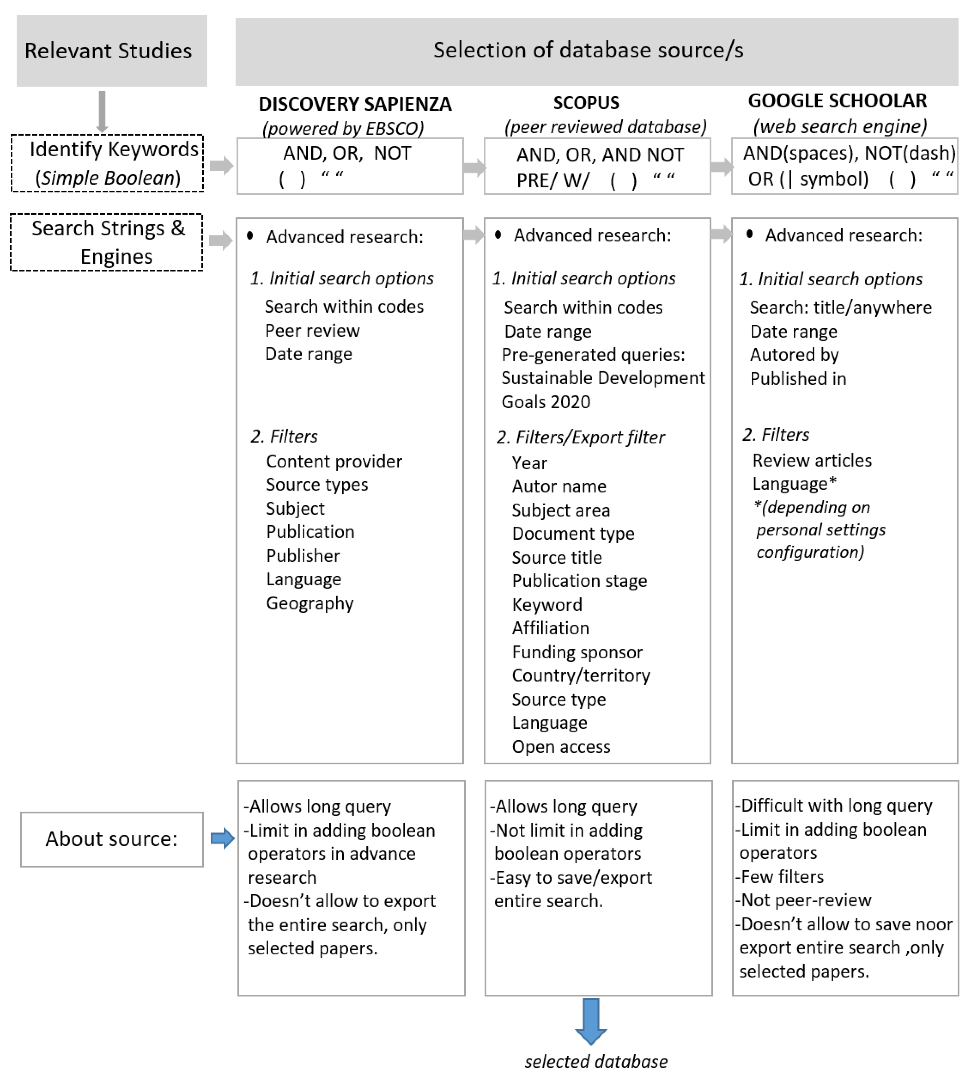
Figure 2.
Adding and modifying Boolean expressions.
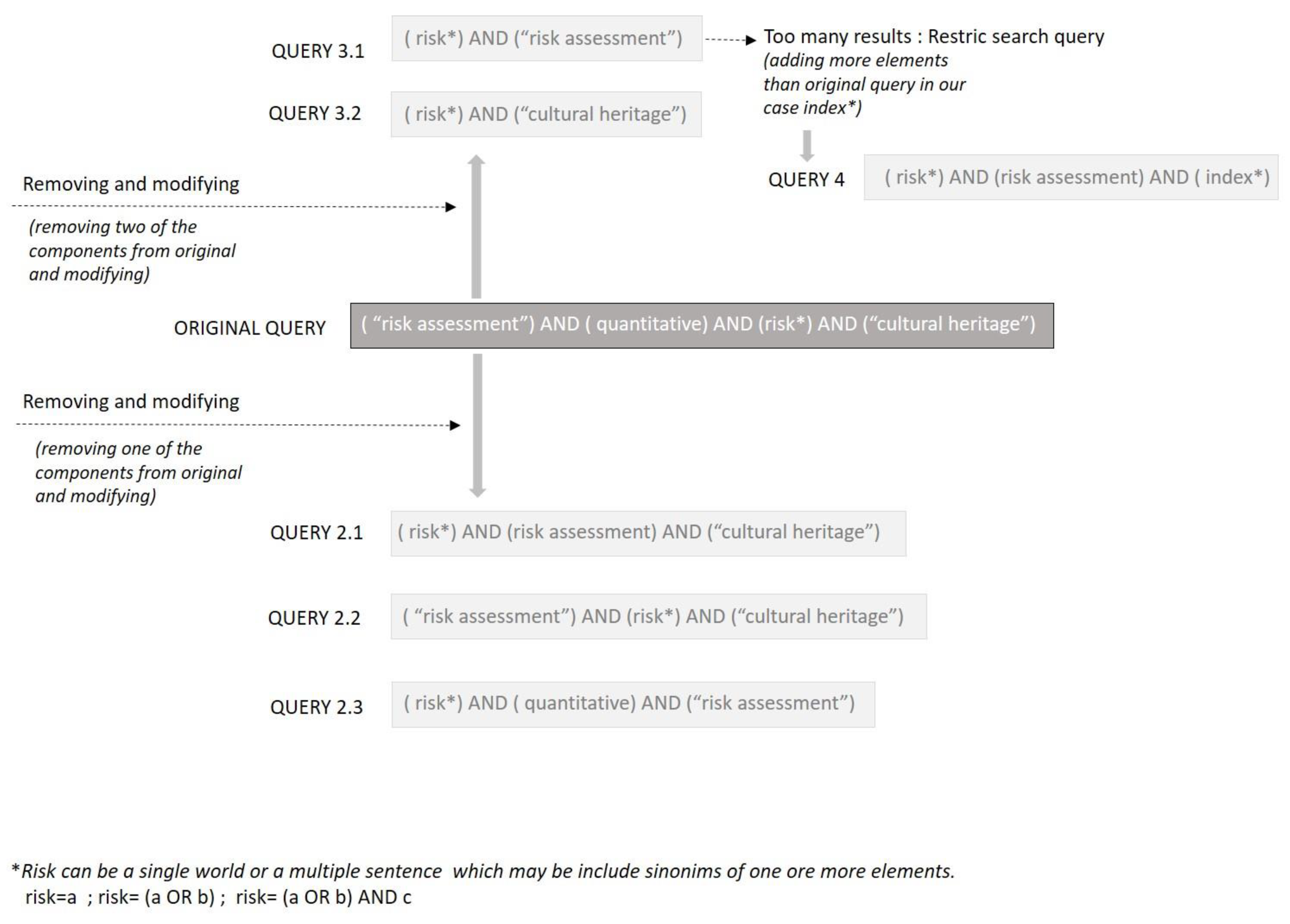
Figure 3.
List of RQs used in SLR.
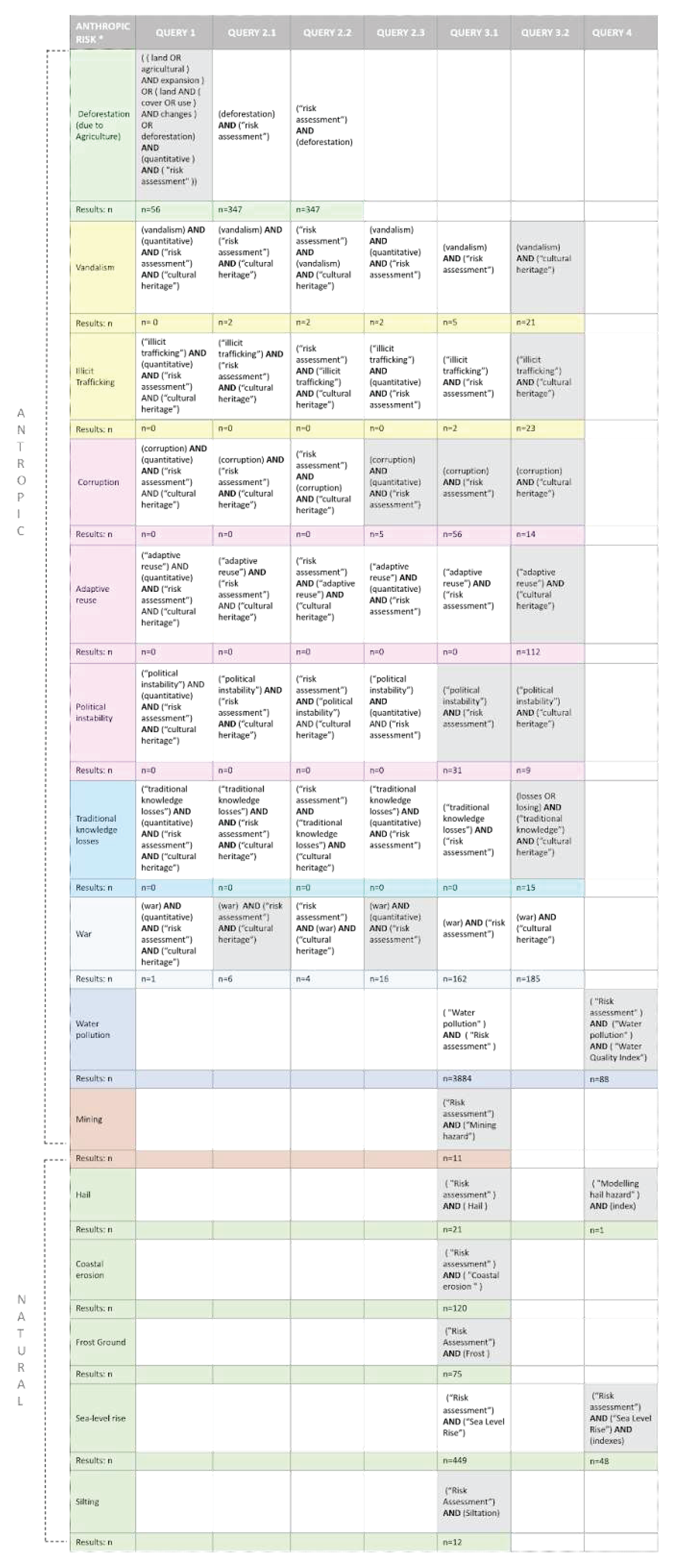
Table 4.
Natural and anthropic risks for which to define the taxonomy.
| NATURAL RISK | ANTHROPIC RISK |
|---|---|
| Severe Weather | Pollution |
| Heat wave | Air pollution |
| Cold wave | Water pollution |
| Fire | Soil pollution |
| Downpour / Heavy rainfall events | Building/Infrastructure/Industry |
| Squall / windstorms | Carbonation and CO2 uptake of concrete |
| Hail | Salt Crystallization |
| Environmental | Corrosion |
| See Level rise | Mining |
| Storm surge | Overtourism |
| Silting | Land Conversion |
| Frost ground | Agriculture/forestation |
| Erosion | Heritage crime |
| Coastal erosion | Vandalism |
| Soil erosion | Illicit trafficking |
| Flood | Management |
| Flood | Corruption |
| Coastal flood | Modern re-use |
| Flash flood | Political |
| Fluvial-riverine flood | Socio-cultural |
| Precipitation-related | Loss of traditional knowledge |
| Desertification | Other |
| Drought | War |
| Geological events | |
| Earthquakes | |
| Volcano | |
| Landslide | |
| Avalanche (indirect) | |
| Tsunami (indirect) | |
| Biological | |
| Decay | |
| Vegetation | |
| Plant Pest | |
| Animal migration | |
| Invasive species | |
| Flora / Fauna | |
| Biodiversity loss |
Table 5.
Construction of the database on natural and anthropic risks with reference to the cultural heritage.
Table 5.
Construction of the database on natural and anthropic risks with reference to the cultural heritage.
| Risk class | Risk type | Specific risk | Probability classes | Indicators | Indices | Unit of measurement | Reference |
Table 6.
ProteCHt2save summary sheet.
| EU Project | Start date – End date | Project partners | Short project description | Classification areas, indices and indicators |
| ProteCHt2save - Risk assessment and sustainable protectionof cultural heritage in changing environment Web source: https://www.protecht2save-wgt.eu/ |
01 July 2017 - 30 June 2020 | Lead partner - Institute of Atmospheric Sciences and Climate – National Research Council of Italy (ISAC-CNR); Institute of Theoretical and Applied Mechanics of the Czech Academy of Sciences (ITAM); University for Continuing Education Krems Danube University Krems (DUK); Municipality of Ferrara (MUF); Municipal District Praha – Troja; Government of Baranya County (GBC); City of Kastela (COK); Municipality of Kocevje (MOK); Regional Development Agency Bielsko-Biala (ARRSA); Bielsko – Biala District. |
The Project came into being with the intent to provide to public and private institutions methods and tools to increase protection, to facilitate management, and to promote a sustainable use of the cultural heritage in the era of climate change. On the operative level, a GIS tool was studied through which to conduct the assessment of the risks derived from climate change to which Central Europe’s cultural heritage is subjected, in order to facilitate decisions on mitigation, protection, and evacuation strategies. This assessment is supplemented by the vulnerability percentage characterizing the cultural heritage subject to study, in order to support the identification of the areas at risk exposed to flooding, drought, and heatwaves. The web-GIS tool collects data and processes climate risk indices for two historic periods, from which two risk scenarios with 30-year projections were projected. Supporting the decision-making phase, manuals are provided illustrating the good practices to be adopted in the various situations, mitigation, prevention, and evacuation. |
NATURAL RISK CLIMATIC EXTREME EVENTS: Heavy rainfalls Floods Warm spells, heat waves and drought Fires INDICES AND INDICATORS: Warm Days (e.g. TX90pa), Cold Days (e.g. TX10pa), Warm Nights (e.g. TN90pa, TRa), Cold Nights/Frosts (e.g. TN10pa, FDa), Extreme Precipitation (e.g., RX1daya, R95pa, R99pa), Dryness (e.g., CDDa)/ Drought |
Table 7.
STRENCH summary sheet.
| EU Project | Start date – End date | Project partners | Short project description | Classification areas, indices and indicators |
| STRENCH STRENgthening resilience of Cultural Heritage at risk in a changing environment through proactive transnational cooperation Web source: https://programme2014-20.interreg-central.eu/Content.Node/STRENCH.html |
01 March 2020 - 28 February 2022 | LP - ISAC-CNR (IT) PP2 - ITAM CAS (CZ) PP3 - DUK (AT) PP4 - FVG (IT) PP5 - SISTEMA (AT) PP6 - LBDCA (HU) PP7 - UIRS (SI) PP8 - LRA FO (DE) PP9 - MoD (HR) |
The Project presents a web GIS platform for multi-risk analysis based on the assessment of indices in relation to phenomena caused by CC. Mapping of the phenomena on the web GIS tool to facilitate consultation for local institutions, in order to increase their skills in the process of setting intervention priorities and defining strategies (preparation / emergency / restoration). An additional element of innovation introduced by the Project is the possibility of analyzing the data in relation to temporal scenarios of the past or future, in order to understand the evolution and therefore to prevent any patterns of change and prepare suitable strategies. |
NATURAL RISK Heavy rain - R20mm Heavy rain - R95pTOT Flooding - Rx5day Flooding - CWD Flooding 1-in-50 return level Drought - CDD Drought - 5 days consecutive dry days Extreme heating – Tx9 Extremely warm days Extreme heating -Seasonal count when TX (daily maximum)>35ºC. Extreme heating- Heat waves index Extreme heating - Tx9 Hot days - Seasonal No. days above average 99th percentile of TX (on basis of 1986-2005) Extreme heating - TR Tropical nights |
Table 8.
Prothego summary sheet.
| EU Project – Horizon 2020 | Start date – End date | Project partners | Short project description | Classification areas, indices and indicators |
| Prothego - PROTection of European Cultural HEritage from GeO-hazards Web source: https://www.prothego.eu/ |
H2020, 2015-2018 | ISPRA — Institute for Environmental Protection and Research, Italy NERC — Natural Environment Research Council, UK CUT — Cyprus University of Technology, Cyprus UNIMIB — University of Milano-Bicocca, Italy IGME — Geological Survey of Spain |
The Project proposes a methodology for the assessment of the risks derived from geomorphological events, like landslides, earthquakes, and phenomena associated with volcanic activity, based on the combination of data originating from remote sensing activities and those present in the national and international databases, in order to identify the European cultural heritage potentially at risk. This activity is aimed at providing a tool for the prevention and assessment of the risks and to facilitate management operations in the planning of mitigation strategies. The investigation activities, suitably completed with operations of surveying and modelling the sites involved in the study, were the basis for the development of a digital map where a summary can be obtained of the potential geomorphological risks for the research’s case studies (monuments and sites in Europe that are included in the UNESCO World Heritage List (WHL), that are potentially unstable due to geological risks). |
NATURAL RISK Probabilistic seismic hazard map of Europe, expressed in terms of 10% exceedance probability in 50 years for Peak Ground Acceleration Landslide – N/A Volcanic hazard - high level (12 Km) - proximal area potentially reached by lava and pyroclastic flows and fall of bombs, tephra and ash; low level (35 Km) - distal area potentially reached only by ash fallout. Subsidence Hazard – Potential Subsidence Baseline land elevation (DEM) and sea level models; Potential coastal erodibility; Vertical motion related to neotectonics. Flood Hazard – N/A |
Table 9.
Heracles summary sheet.
| EU Project – Horizon 2020 | Start date – End date | Project partners | Short project description | Classification areas, indices and indicators |
| Heracles - Heritage resilience against climate events on site Web source: http://www.heracles-project.eu/ |
H2020, 1 May 2016 - 30 April 2019 | CNR - Consiglio Nazionale delle Ricerche E-GEOS SPA LEONARDO - Societa per azioni THALES Italia SPA FRAUNHOFER GESELLSCHAFT ZUR FORDERUNG DER ANGEWANDTEN FORSCHUNG EV ARIA TECHNOLOGIES SAS SISTEMA GMBH CVR S.R.L. CONSORZIO INTERUNIVERSITARIO NAZIONALE PER LA SCIENZA E TECNOLOGIA DEI MATERIALI UNINOVA-INSTITUTO DE DESENVOLVIMENTO DE NOVAS TECNOLOGIAS-ASSOCIACAO THE INTERNATIONAL EMERGENCY MANAGEMENT SOCIETY AISBL EUROPEAN MATERIALS RESEARCH SOCIETY IDRYMA TECHNOLOGIAS KAI EREVNAS PANEPISTIMIO KRITIS EPHORATE OF ANTIQUITIES OF HERAKLION COMUNE DI GUBBIO UNIVERSITA DEGLI STUDI DI PERUGIA |
The development of an ICT digital platform for the management of sites that are potentially unstable due to risks associated with climate change is the focus of the Heracles Project. The digital platform collects multi-scale data derived from various sources: from remote sensing to the modelling of the sites subject to study, and on-site monitoring of the parameters that may contribute towards the assessment of the potential risks derived from climate change. In addition to providing threshold values that, when exceeded, trigger an alert system, the database is effective for supporting conservation decisions and helping the interested parties prioritize operations and investments to improve the resilience of the cultural heritage. The methodology relating to the assessment of the risks proposed by the research differs from the others in that it starts from identifying the environmental and climate parameters, from whose variation the potential risks for the cultural heritage may be derived. These risks are explained along with the possible effects on the cultural heritage with a multi-scale dimension. |
NATURAL HAZARDS: floods, storms, earthquakes; ANTHROPIC HAZARDS: Environmental pollution. |
Table 10.
Storm summary sheet.
| EU Project – Horizon 2020 | Start date – End date | Project partners | Short project description | Classification areas, indices and indicators |
| STORM – Heritage resilience against climate events on site Web source: http://www.storm-project.eu/ |
H2020, 1 June 2016 - 31 May 2019 | Engineering Ingegneria Informatica (ENG). Instituto de Novas Tecnologias (INOV); Foundation for Research and Technology (FORTH); Piraeus University of Applied Sciences (Technological Educational Institute of Piraeus – TEIP); Tuscia University (TUSCIA); University of Stuttgart (USTUTT); University of Salford (USAL). ResilTech (RESIL); KPeople (KP); Sparta Digital (SPA); Nova Conservação (NCR); Soprintendenza Speciale per il Colosseo, il Museo Nazionale Romano e l’Area archeologica di Roma (SSCOL); Mellor Archaeological Trust (MAT); Troia Resort (TRO); Ephorate of Antiquities of Rethymno (EFARETH); Bogazici University (BU). Direçaõ-Geral do Património Cultural (DGPC); Zentralanstalt für Meteorologie und Geodynamik (ZAMG). Corpo Nazionale dei Vigili del Fuoco (CNVV); Municipio de Grãndola (SMPC). |
The STORM project focused on the implementation of decision-making tools for the purpose of facilitating the protection of historic centres and archaeological sites affected by climate change and by natural risks. One of the outputs of the research was a collaborative platform for collecting and capitalizing on skills and knowledge on the topic. Underlying the platform is the development of a set of new forecast models and non-invasive onsite investigation methods based on the IoT. This permits effective forecasts on environmental changes and a simpler identification of threats and conditions that might damage the sites with a multi-scale dimension. Moreover, through the “Safeguard of Cultural Heritage Recommendations in Government Politics” document, the project collects a set of guidelines and good practices originating from international protocols starting from 2015, with a focus on the management of cultural heritage and on the strategies for the mitigation of climate change. |
NATURAL RISK Table 11 |
Table 11.
STORM index of natural risk related to CC.
| Climate Indices | ||
|---|---|---|
| Index | Name | Definition |
| CFD | consecutive frost days | number of consecutive days per time period with daily minimum temperature below 0°C |
| CSU | consecutive summer days | number of consecutive days per time period with daily maximum temperature above 25°C |
| ETR | intra period extreme temperature | intra-period difference of the maximum of maximum temperature and the minimum of minimum temperature |
| FD | frost days | number of days per time period with daily minimum temperature below 0°C (yearly mean) |
| HD | heating degree days | sum of the difference between room temperature (17°C) and daily mean temperature on days when daily mean temperature is below a constant value (17°C) |
| ID | ice days | number of days per time period with daily maximum temperature below 0°C (yearly mean) |
| SU | summer days | number of days where the daily maximum temperature is above 25°C (yearly mean) |
| TR | tropical nights | number of days where the daily minimum temperature is above 20°C (yearly mean) |
| Tg10p | cold days percent wrt 10th percentile of reference period | percentage of days per time period where daily mean temperature is below the 10th percentile of daily mean temperatures of a 5-day window centred on each calendar day of a given 30-year climate reference period |
| Tg90p | warm days percent wrt 90th percentile of reference period | percentage of days per time period where daily mean temperature is above the 90th percentile of daily mean temperatures of a 5-day window centred on each calendar day of a given 30-year climate reference period |
| Tn10p | cold nights percent wrt 10th percentile of reference period | percentage of days per time period where daily minimum temperature is below the 10th percentile of daily minimum temperatures of a 5-day window centred on each calendar day of a given 30-year climate reference period |
| Tn90p | warm nights percent wrt 90th percentile of reference period | percentage of days per time period where daily minimum temperature is above the 90th percentile of daily minimum temperatures of a 5-day window centred on each calendar day of a given 30-year climate reference period |
| Tx10p | very cold days percent wrt 10th percentile of reference period | percentage of days per time period where daily maximum temperature is below the 10th percentile of daily maximum temperatures of a 5-day window centred on each calendar day of a given 30-year climate reference period |
| Tx90p | very warm days percent wrt 90th percentile of reference period | percentage of days per time period where daily maximum temperature is above the 90th percentile of daily maximum temperatures of a 5-day window centred on each calendar day of a given 30-year climate reference period |
| CDD | consecutive dry days | number of consecutive days per time period with daily precipitation amount below 1 mm |
| CWD | consecutive wet days | number of consecutive days per time period with daily precipitation amount at least 1 mm |
| R75p | moderate wet days wrt 75th percentile of reference period | percentage of days where precipitation is higher than the calendar 75th percentile (centred on a 5-day window) of the reference period |
| R75ptot | precipitation percent due to r75p days | total precipitation in a given period when daily precipitation is larger than the 75th percentile of the reference period |
| R90p | wet days wrt 90th percentile of reference period | percentage of days where precipitation is higher than the calendar 90th percentile (centred on a 5-day window) of the reference period |
| R90ptot | precipitation percentage due to r90p days | total precipitation in a given period when daily precipitation is larger than the 90th percentile of the reference period |
| R95p | very wet days wrt 95th percentile of reference period | percentage of days where precipitation is higher than the calendar 95th percentile (centred on a 5-day window) of the reference period |
| R95ptot | precipitation percentage due to r95p days | total precipitation in a given period when daily precipitation is larger than the 95th percentile of the reference period |
| R99p | extremely wet days wrt 99th percentile of reference period | percentage of days where precipitation is higher than the calendar 99th percentile (centred on a 5-day window) of the reference period |
| R99ptot | precipitation percentage due to r99p days | total precipitation in a given period when daily precipitation is larger than the 99th percentile of the reference period |
| PD | precipitation days | number of days per time period with daily precipitation equal or greater than 1 mm (yearly mean) |
| RR1 | wet days | number of days per time period with daily precipitation of at least 1 mm (yearly mean) |
| R10mm | heavy precipitation days | number of days per time period with daily precipitation equal or greater than 10 mm (yearly mean) |
| R20mm | very heavy precipitation days | number of days per time period with daily precipitation equal or greater than 20 mm (yearly mean) |
| RX1day | highest one day precipitation amount | maximum of one day precipitation amount in a given time period |
| RX5day | highest 5-day precipitation amount | highest precipitation amount for 5-day interval |
| SDII | simple daily precipitation intensity index | mean of precipitation amount on wet days. A wet day is a day with a precipitation sum of at least 1 mm. |
| STRWIN | strong wind days | number of days where wind speed maximum is greater than or equal to 10.5 m/s (yearly mean) |
| STRBRE | strong breeze days | number of days where wind speed maximum is greater than or equal to 10.5 m/s (yearly mean) |
| STRGAL | strong gale days | number of days where wind speed maximum is greater than or equal to 20.5 m/s (yearly mean) |
| HURR | hurricane days | number of days where wind speed maximum is greater than or equal to 32.5 m/s (yearly mean) |
Table 12.
Resin summary sheet.
| EU Project – Horizon 2020 | Start date – End date | Project partners | Short project description | Classification areas, indices and indicators |
| RESIN - Climate Resilient Cities and Infrastructures Web source: https://cordis.europa.eu/project/id/653522 |
H2020, 1 May 2015 - 31 October 2018 | FRAUNHOFER GESELLSCHAFT ZUR FORDERUNG DER ANGEWANDTEN FORSCHUNG EV; FUNDACION TECNALIA RESEARCH & INNOVATION; ICLEI EUROPEAN SECRETARIAT GMBH (ICLEI EUROPASEKRETARIAT GMBH); ECOLE DES INGENIEURS DE LA VILLE DEPARIS; ITTI SP ZOO; STICHTING KONINKLIJK NEDERLANDS NORMALISATIE INSTITUUT; ARCADIS NEDERLAND BV; ASOCIACION BC3 BASQUE CENTRE FOR CLIMATE CHANGE - KLIMA ALDAKETA IKERGAI; HLAVNE MESTO SLOVENSKEJ REPUBLIKY BRATISLAVA; THE UNIVERSITY OF MANCHESTER; UNIVERZITA KOMENSKEHO V BRATISLAVE; AYUNTAMIENTO DE BILBAO; OLDHAM METROPOLITAN BOROUGH COUNCIL; SIEMENS AKTIENGESELLSCHAFT OESTERREICH; SIEMENS AKTIENGESELLSCHAFT; UNIRESEARCH BV |
The project provides standardized methodologies for vulnerability assessment, assessment of performance as relates to adaptation measures as a tool to support the decisions and the development of solid adaptation strategies tailored to the city. In this regard, three tools were developed, as well as a guide to support the decision-making phase: the “Adaptation eGuide” (tool to support the development of adaptation plans and strategies), an interactive map that allows climate risks in Europe to be displayed, and lastly a database of solutions for adaptation and mitigation of the risks connected to climate change. The guide developed in the consortium explains the IVAVIA (Impact and Vulnerability Analysis of Vital Infrastructures and built-up Areas) methodology, a risk-based vulnerability assessment that allows the interested parties to map, analyze, and communicate the impact of climate scenarios and of meteorological events in an urban area. The tools and guide are available online in open access, with a very simple interface. |
NATURAL RISK Wildfire hazard - This indicator identifies the proportion of the NUTS 3 region defined as 'burnt areas' according to the 2012 Corine classification. Coastal hazard - This indicator provides data on the % of the total length of the NUTS3 unit coastline (in km) that is exposed to a 1 in 100 year coastal storm surge, and also the % of the total length of the coastline that is exposed to 1 meter sea level rise. Drought hazard - This indicator utilises the Standardized Precipitation-Evapotranspiration Index (SPEI) at nine month timescales to provide a measure of meteorological drought. Fluvial hazard - This indicator uses Joint Research Centre (JRC) flood mapping data to show the percentage of the total area of the NUTS3 area that would be prone to flooding in the event of a 1 in 100 year fluvial flood. Landslide hazard - This indicator draws on NASA’s Global Landslide Susceptibility Map, which identifies the potential for landslides across the Earth’s surface on a scale from slight to severe. Mean temperature - This indicator shows the difference in daily mean temperature between the 1981- 2010 period (observed baseline) and the 2036-2065 period (future projection). Maximum temperature -This indicator shows the difference in maximum temperature between the 1981- 2010 period (observed baseline) and the 2036-2065 period (future projection). Summer days - This indicator shows the difference in the number of days with a maximum temperature more than 25°C between the 1981-2010 period (observed baseline) and the 2036-2065 period (future projection). Tropical nights - This indicator shows the difference in the number of nights where the minimum temperature does not drop below 20°C between the 1981-2010 period (observed baseline) and the 2036-2065 period (future projection). Heat wave days - This indicator shows the difference in the number of days with a maximum temperature of more than 35°C between the 1981-2010 period (observed baseline) and the 2036-2065 period (future projection). Minimum temperature -This indicator shows the difference in minimum temperature between the 1981- 2010 period (observed baseline) and the 2036-2065 period (future projection). Frost days - This indicator shows the difference in the number of days with a minimum temperature of less than 0°C between the 1981-2010 period (observed baseline) and the 2036-2065 period (future projection). Ice days - This indicator shows the difference in the number of days with a maximum temperature of less than 0°C between the 1981-2010 period (observed baseline) and the 2036-2065 period (future projection). Total wet-day precipitation - This indicator shows the difference between the 1981-2010 period (observed baseline) and the 2036-2065 period (future projection) in the cumulated precipitation for days with precipitation greater than or equal to 1mm. Consecutive wet days - This indicator shows the difference between the 1981-2010 period (observed baseline) and the 2036-2065 period (future projection) in the number of consecutive wet days with precipitation greater than or equal to 1mm. Heavy precipitation days - This indicator shows the difference between the 1981-2010 period (observed baseline) and the 2036-2065 period (future projection) in the number of days with precipitation greater than or equal to 10mm. Very heavy precipitation days - This indicator shows the difference between the 1981-2010 period (observed baseline) and the 2036-2065 period (future projection) in the number of days with precipitation greater than or equal to 20mm. Consecutive dry days - This indicator shows the difference between the 1981-2010 period (observed baseline) and the 2036-2065 period (future projection) in the number of consecutive dry days with precipitation less than 1mm. |
Table 13.
Shelter summary sheet.
| EU Project – Horizon 2020 | Start date – End date | Project partners | Short project description | Classification areas, indices and indicators |
| SHELTER - Sustainable Historic Environments hoListic reconstruction through Technological Enhancement and community based Resilience Web source: https://shelter-project.com/ |
H2020, 1 June 2019 - 31 May 2023 | Engineering Ingegneria Informatica (ENG). Instituto de Novas Tecnologias (INOV); Foundation for Research and Technology (FORTH); Piraeus University of Applied Sciences (Technological Educational Institute of Piraeus – TEIP); Università degli Studi della Tuscia (TUSCIA); University of Stuttgart (USTUTT); University of Salford (USAL). ResilTech (RESIL); KPeople (KP); Sparta Digital (SPA); Nova Conservação (NCR); Soprintendenza Speciale per il Colosseo, il Museo Nazionale Romano e l’Area archeologica di Roma (SSCOL); Mellor Archaeological Trust (MAT); Troia Resort (TRO); Ephorate of Antiquities of Rethymno (EFARETH); Bogazici University (BU). Direçaõ-Geral do Património Cultural (DGPC); Zentralanstalt für Meteorologie und Geodynamik (ZAMG). Corpo Nazionale dei Vigili del Fuoco (CNVV); Municipio de Grãndola (SMPC). |
The Project is founded upon the evidence of the direct and indirect impacts of climate change on the tangible cultural heritage and the need to supply methods and tools of use for the identification, assessment, and consequent mitigation of risks associated with the phenomenon introduced above. In-depth understanding of the risk assessment is crucial in defining a methodology, tools, and strategies of use for improving resilience and guaranteeing sustainability that may be applied in different European settings and on various components of the cultural heritage. Supporting this process, the framework was implemented with a digital platform based on multi-scale data through which to access the information necessary for a governance of the risks that is as holistic as possible. |
NATURAL RISK Geophysical (Originated from mass movement of solid earth) Earthquake – PGA (Peak Ground Acceleration) = 0.5 Subsidence - Threshold 10 mm/year Meteorological (Short-term or small-scale weather conditions) Severe wind/storm – Storm Gale >75 km/h, Hurricane >117 km/h Heat wave – Heatwave Number HWN, Heatwave Frequency HWF, Heatwave Amplitude HWA Climatological (Long-term or large-scale atmospheric processes) Forest fire and land fire – FIRE WEATHER INDEX Hydrological (Mass movement of water influenced by meteorological) Surface flood/runoff River flood – Flood Peak flow rate (m3/s), Time to flood peak (hours), Flood Peak Volume (m3), Pluvial flood – Flood Peak height (m), Time to flood peak (hours) |
Table 14.
Hazard taxonomy through AI chatbot.
| HUMAN QUERY | CHATBOT ANSWER |
|---|---|
| “Coastal flood indices” | Coastal flood indices and metrics are used to assess the potential risks and impacts of coastal flooding events, including storm surges and sea level rise. These metrics help researchers, coastal planners, and policymakers understand the vulnerability of coastal areas and make informed decisions for adaptation and mitigation strategies. Here are some coastal flood indices and metrics, along with potential sources for scientific references:
|
| “Coastal flood metrics” | Certainly, here are some common coastal flood indices and metrics along with their corresponding units of measure:
|
| “Scientific references about Coastal flood indices and metrics” |
|
Table 15.
Risk to be evaluated with SLR process.
| RISKS NATURALI | RISKS ANTHROPIC |
|---|---|
| Severe Weather | Pollution |
| Hail | Water pollution |
| Environmental | Building/Infrastructure/Industry |
| See Level rise | Mining |
| Silting | Land Conversion |
| Frost ground | Agriculture/forestation |
| Erosion | Heritage crime |
| Coastal erosion | Vandalism |
| Illicit trafficking | |
| Management | |
| Corruption | |
| Moder re-use | |
| Political | |
| Socio-cultural | |
| Loss of traditional knowledge | |
| Other | |
| War |
Table 16.
The inclusion and exclusion criteria for the SLR.
| Factor | Inclusion Criteria | Exclusion Criteria |
| Document Type | Peer-reviewed journal articles; Peer-reviewed conference articles; Primary research |
Grey literature (e.g., M.Sc. and Ph.D. theses); Books and book chapters; Secondary research. |
| Year Range | Between 2013–2023 | Before 2013 and after 2023 |
| Ultimate context and intimate context |
All kinds of cultural heritage (e.g., urban context, historical sites, historical buildings, landscape); Discusses quantitative risk assessment for a specific hazard in generic contexts, including cultural heritage ones |
Qualitative risk assessment |
| Relevance to the objectives |
The articles address “Risk Assessment” for a specific hazard* and answer one or more research query(ies). | The article discusses a specific topic not relevant to the research queries. |
| Language | English | Limited to (English) |
| Research topic | Qualitative anthropic’s risks assessment |
Table 17.
SLR on water pollution.
| Name | Query | Documents |
| Water Pollution | (Risk assessment) AND (Water pollution) AND (Water Quality Index) | 88 (Appendix 1) |
Table 18.
SLR on hail.
| Name | Query | Documents |
| Hail | (Risk assessment) AND (Hail) | 22 (Appendix 2) |
Table 19.
SLR on coastal erosion.
| Name | Query | Documents |
| Coastal Erosion | (Risk assessment) AND (Coastal erosion ) | 120 (Appendix 3) |
Table 20.
SLR on siltation.
| Name | Query | Documents |
| Siltation | (Risk Assessment) AND (Siltation) | 12 (Appendix 4) |
Table 21.
SLR on frost.
| Name | Query | Documents |
| Frost | (Risk Assessment) AND (Frost) | 74 (Appendix 5) |
Table 22.
SLR on sea-level rise.
| Name | Query | Documents |
| Sea Level Rise | (Risk assessment) AND (Sea Level Rise) AND (indexes) | 48 (Appendix 6) |
Table 23.
SLR on mining.
| Name | Query | Documents |
| Mining | (Risk assessment) AND (Mining hazard) | 11 (Appendix 7) |
Table 24.
SLR on deforestation/land conversion.
| Name | Query | Documents |
| Deforestation/Land conversion | (land OR agricultural) AND expansion) OR (land AND (cover OR use) AND changes) OR deforestation) AND (quantitative) AND ("risk assessment") | 56 (Appendix 8) |
Table 25.
SLR on vandalism.
| Name | Query | Documents |
| Vandalism | (vandalism) AND ("cultural heritage") | 21 (Appendix 9) |
Table 26.
SLR on illicit trafficking.
| Name | Query | Documents |
| Illicit trafficking | ("illicit trafficking") AND ("cultural heritage") | 23 (Appendix 10) |
Table 27.
SLR on corruption.
| Name | Query | Documents |
| Corruption | (corruption) AND (quantitative) AND (“risk assessment”) | 5 (Appendix 11) |
| Corruption | (corruption) AND ("risk assessment") | 56 (Appendix 12) |
| Corruption | (corruption) AND (quantitative) AND (“risk assessment”) | 14 (Appendix 13) |
Table 28.
SLR on adaptive reuse.
| Name | Query | Documents |
| Adaptive reuse | (“adaptive reuse”) AND (“cultural heritage”) | 112 (Appendix 14) |
Table 29.
SLR on traditional knowledge losses.
| Name | Query | Documents |
| Traditional knowledge losses | (losses OR losing) AND (“traditional knowledge”) AND (“cultural heritage”) | 15 (Appendix 15) |
Table 30.
SLR on political instability.
| Name | Query | Documents |
| Political instability | (“political instability”) AND (“risk assessment”) | 31 (Appendix 16) |
| Political instability | (“political instability”) AND (“cultural heritage”) | 9 (Appendix 17) |
Table 31.
SLR on War.
| Name | Query | Documents |
| War | (war) AND (“risk assessment”) AND (“cultural heritage”) | 6 (Appendix 18) |
| War | (war) AND (quantitative) AND (“risk assessment”) | 16 (Appendix 19) |
Disclaimer/Publisher’s Note: The statements, opinions and data contained in all publications are solely those of the individual author(s) and contributor(s) and not of MDPI and/or the editor(s). MDPI and/or the editor(s) disclaim responsibility for any injury to people or property resulting from any ideas, methods, instructions or products referred to in the content. |
© 2024 by the authors. Licensee MDPI, Basel, Switzerland. This article is an open access article distributed under the terms and conditions of the Creative Commons Attribution (CC BY) license (http://creativecommons.org/licenses/by/4.0/).
Copyright: This open access article is published under a Creative Commons CC BY 4.0 license, which permit the free download, distribution, and reuse, provided that the author and preprint are cited in any reuse.


