Submitted:
05 January 2024
Posted:
05 January 2024
You are already at the latest version
Abstract
In addition to changes in the amount of rain, changes in land use upstream are considered a factor that directly affects the maximum runoff flow in a basin, especially in areas that have experienced floods and flash floods. This research article presents the application of the SWAT model to assess runoff in areas that have experienced flash floods, in order to analyze the proportion of land use change to the maximum runoff. Study areas that had experienced flash floods were in 3 basins in Thailand (Lam Saphung Basin, Phrom River Basin, and Chern River Basin Part 1 which is a subbasin of the Nam Chi River Basin). This study analyzed two main factors that influence runoff in the river basin: Changes in rainfall and changes in land use by considering 2 simulation situations.: (1) Changes in land use affecting runoff assessed by considering land use maps in 2006, 2008, 2010, 2015, 2017, 2019, and 2021 when using rainfall data only in the year 2021 for all cases, and (2) Changes in the amount of rainfall influencing runoff by considering the rainfall record in 2006, 2008, 2010, 2015, 2017, 2019, and 2021 when using the land use data only in the year 2021 for all cases. The results of the study found that the SWAT model can be effectively applied to estimate annual runoff in areas that have experienced flash floods under 8 parameters with R2 values of 0.74, 0.82 and 0.74 for the Lam Saphung River Basin and the Phrom River Basin and the Chern River Basin Part 1 respectively. In addition, it was found that the proportion of land use changes that involved changes from forest areas to residential areas was the greatest from 2008 to 2010 in the Phrom River Basin and Chern River Basin Part 1. This resulted in an increase in the maximum runoff amount of 77.78% and 46.87%, respectively. When land use was constant, it was found that the rainfall in 2010, which was the highest, also had the greatest impact on the runoff in all 3 areas.
Keywords:
Flash Flood Area
; Runoff
; SWAT
; Land Use Change
; Rainfall Runoff
1. Introduction
The occurrence of floods and flash floods remains an ongoing problem. There is also an increase in frequency and severity. At the same time, water shortages in the dry season are a continuous and long-standing problem. The continued increase in the severity of floods and droughts in line with rising global temperatures is a clear sign of global climate change. This is caused by the rapid expansion and growth of the economy throughout every region. This increases the demand for land and water and increased severity of events. is considered to be the source of problems involving both floods and droughts [1,2]. Changes in rainfall patterns caused by climate change and extreme weather events can produce rain that varies in appearance and in increased frequency [3,4,5]. This ongoing climate change is having a major impact on both floods and droughts, increasing the impact on life, social resources and infrastructure in every region of the world [6,7].
Changes in rainfall patterns caused by climate change and land use changes have resulted in flooding events. They have three main characteristics: river floods, coastal floods, and flash floods [8,9,10]. According to the National Weather Service and USGS, flash floods account for the highest proportion of flood-related deaths and flash floods are becoming an increasingly common occurrence around the world [11,12]. Flash flooding is often associated with intense rainfall [13,14]. However, in some areas, such as in cities, drainage is poorly man-aged, and slope changes can present a risk of flooding. In extreme cases, flooding can pose a threat to public safety and may result in loss of life and. The time-scale of flash floods in which hydrologic and meteorological conditions are involved is short with periods lasting from minutes to hours [15,16]. Flash floods often occur in areas where the soil does not absorb water readily (e.g. clay soils) and there is an increase in runoff at rivers and other water channels [17,18]. Flash floods can be very severe but there are few opportunities for protection. Flash floods also affect the well-being of people who are most affected by widespread flooding. The causes of the risk of flash floods can be both natural events, such as changes in rainfall patterns, but also human agency, such as changes in land use, which could potentially be prevented by effective planning.
At present, the study and analysis of factors affecting flood occurrence still faces some limitations. Estimating the amount of runoff in areas that have previously experienced flash floods has not been widely studied [19,20]. There has been little study of factors related to flash floods in both river basins and economic areas [21,22]. Data from pilot case studies are important in developing methods for estimating runoff from areas that have experienced recent and past flash floods. Improving watershed areas as part of flash flood management will be an important and useful way for local authorities to prevent and mitigate future floods [23,24]. In addition, such studies will provide important information for decision making in future land use planning, such as changing land use from forest areas to cities or from forest areas to agriculture, etc.
However, the complexity and characteristics of the studied basin, (such as topographic size, land use, and hydrologic processes), can influence the model's parameter range and sensitivity in capturing the dynamics of flood events and runoff assessments. The choice of model and underlying equations can have an impact on parameter range and sensitivity. Therefore, the SWAT model is suitable for describing flood events with accurate details and has been accepted for evaluating the impact of land and climate change on flooding and runoff in a basin [25,26,27,28,29]. There is also a SWAT-CUP (Soil and Water Assessment Tool - Calibration and Uncertainty Procedures) model developed from SWAT to help determine parameters appropriate to the topography and area of the studied basin [30,31,32]. Hydrological analysis helps to quickly assess runoff during flood events to achieve a comprehensive assessment [33,34,35]. Additionally, the use of advanced models allows for a thorough understanding of the complex processes that result in flooding [36,37,38]. This makes it possible to use the results of study to plan to prevent future events.
In the past, the SWAT model has been applied to assess runoff from changes in climate conditions and various land uses [39,40,41,42]. In Thailand, there have been various analyzes of land use changes on runoff that also used SWAT models [43]. However, this study was limited to a single watershed and did not map past land use changes over a sufficiently long timescale. The results still cannot explain the details of land use factors and cannot truly be used in planning prevention as they lack details on the proportion of land use changes that affect flash floods and changes in maximum runoff volume. Moreover, the parameters that directly affect the runoff volume are not classified. This may not allow comprehensive tracking of long-term trends or extreme events. Moreover, nowadays it is rare to find research that applies the SWAT model to assess runoff in areas that have experienced flash floods. There is a need to analyze the causes and factors that will enable planning for response and prevention in the future, including expansion of use in other areas.
Therefore, this research applied the SWAT model to assess the amount of run-off in areas that have experienced flash floods in 3 river basins in Thailand (the Lam Saphung River Basin, the Lam Phrom River Basin, and the Chern River Basin Part 1), by analyzing two main factors from a simulation scenario of land use changes from the past and a simulation scenario of changing rainfall in the year considered. Analysis included investigation of the proportion of land use changes to the maximum runoff volume.
2. Materials and Methods
This research applied the SWAT model to assess runoff in areas that have experienced flash floods and used SWAT-CUP to help determine parameters appropriate to the topography and representative area of the studied watershed [44,45]. Two main events were considered. (1), The simulation scenario of land use change from the past to the present, using land use maps in the years 2006, 2008, 2010, 2015, 2017, 2019, and 2021 by considering the least amount of rain in the year 2021 only, and (2) The simulated situation of changing rainfall in the year under consideration which used land use maps only in the year 2021 were analyzed. The steps of the study were as shown in Figure 1.
From Figure 1, it can be seen that this study began by collecting various data that were then used in the SWAT-CUP model, such as maps showing the height of the area, land use maps, and soil type maps. The input data such as spatial data, climate and meteorological data, ground level (DEMs for 30 m and 5 m) was used in the SWAT model [46]. These data were then imported into the SWAT model to estimate runoff. The evaluation process consisted of a calibration process (Training) and a validation process performed by searching for various parameters obtained from the SWAT-CUP model that are appropriate to the data and then using them. Then, the amount of runoff could be assessed from simulated situations representing all 3 areas. Each area was processed in the same way. (1) Evaluate runoff from changes in land use by specifying the use of rainfall in 2021 only. Then change the land use according to different years. (2) Evaluate runoff from changes in the amount of rainfall by specifying the use of land use maps only for 2021 and changing the amount of rainfall according different years.
2.1. Study Area
The study area selected for research comprised three basins that have experienced flash floods, namely the Lam Saphung Basin, the Phrom Basin, and the Chern Basin Part 1. These three basins are subbasins of the Chi River basin which is located in the northeastern region of Thailand as shown in Figure 2. In addition, all 3 basin areas have completed land use and rainfall map data is available which can be used to evaluate the occurrence of runoff at different times.
From Figure 2, it is seen that these 3 basins have different characteristics under watershed conditions, even though they are adjacent areas. Information on the general condition and details of each basin are described below.
2.1.1. Lam Saphung River Basin
The Lam Saphung River Basin, is a subbasin of the Chi Basin with an area of 743.74 km2 covering 1.51 % of the main basin. This area covers Kaset-somboon District, Nong Bua Daeng District and Khon San District in Chaiyaphum Province. The average annual rainfall is about 1,203.4 mm. The total runoff volume is 229.6 MCM (million cubic meters), with runoff volume per unit area of 9.8 l/s-m2 (liters/second/square meter).
2.1.2. Phrom River Basin
The Phrom River basin is a subbasin of the Chi River basin with an area of 2,264.66 km2 covering 4.60 % of the main river basin. This area covers Kaset Sombun District, Phu Khiao District, Ban Thaen District and Khon San District in Chaiyaphum Province, Chum Phae District in Khon Kaen Province, Mueang Phetchabun District, Lom Sak District and Nam Nao District in Phetchabun Province. The average annual rainfall is about 1,080.3 mm. Total runoff volume is 435.3 MCM with runoff volume per unit area 6.1 l/s-m2.
2.1.3. Chern River Basin Part 1
The Chern Basin Part 1 is a subbasin of the Chi Basin with an area of 1,899.65 km2 covering 3.86 % of the main basin. This area covers Kaset Sombun District, Phu Khiao District, Ban Thaen District and Khon San District in Chaiyaphum Province, Chum Phae District in Khon Kaen Province, Lom Sak District and Nam Nao District in Phetchabun Province. The average annual rainfall is about 1,104.4 mm. Total runoff volume is 363.8 MCM with runoff volume per unit area 6.1 l/s-m2.
2.2. Data Preparation
Data preparation for this research involved selected river basin areas that had experienced flash floods in 2021 using flash flood and flash flood data from the system https://data.dmr.go.th/dataset/debris_flood [47,48] by the Department of Mineral Resources. Flash flood events were selected for study only in the Lam Saphung Basin, Phrom River Basin, and Chern River Basin Part 1. Each basin has different characteristics. The input data format was collected from relevant agencies as shown in Table 1.
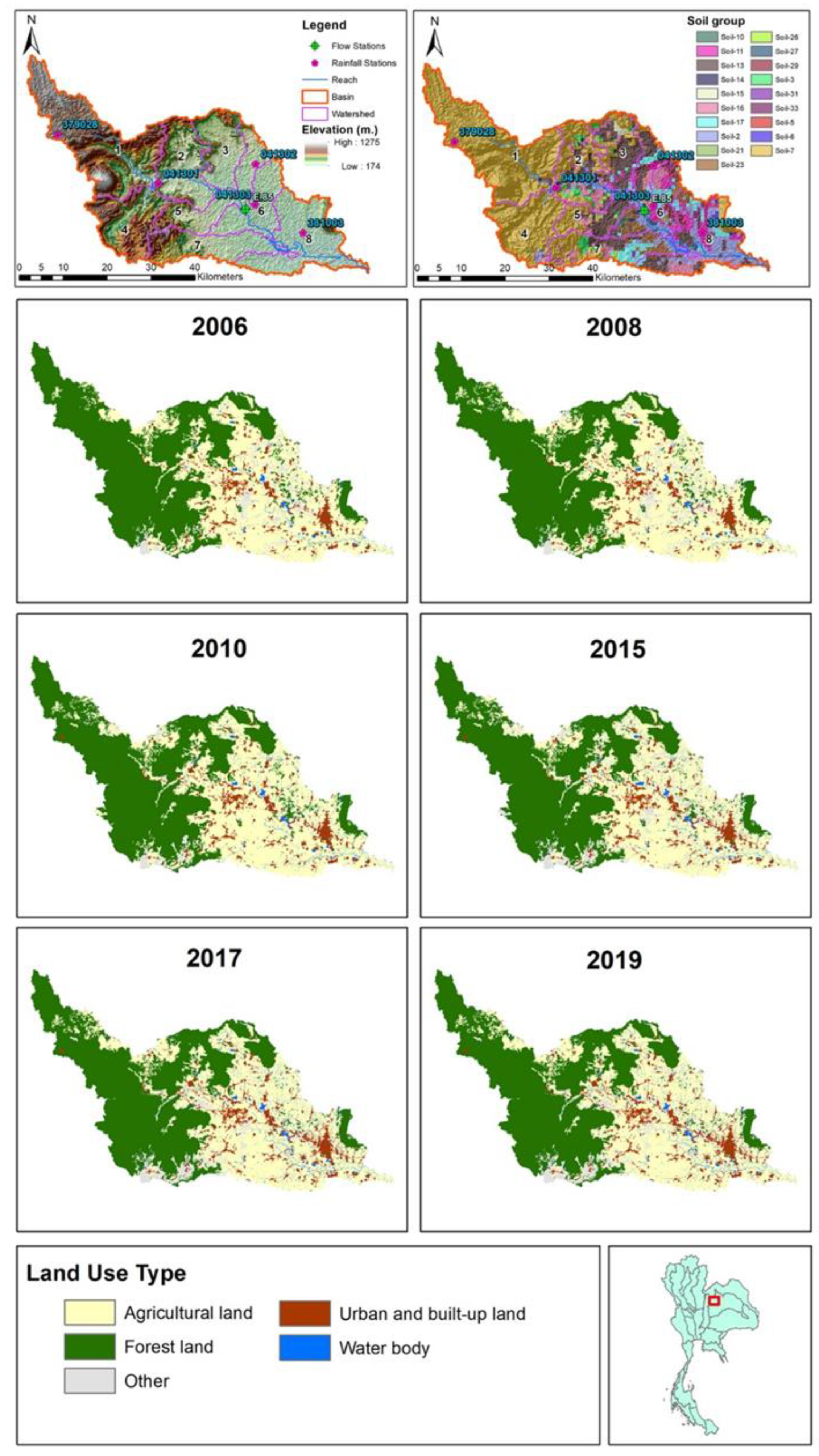
The data shown in Table 1 were used as input into the SWAT model representing all 3 areas and consisted of (1) a numerical elevation model (DEM) using ASTER DEM (30 m.), (2) a soil series map and land use maps for 2006-2019 from the Land Development Department, and (3) meteorological data 2006-2019 from the Meteorological Department and meteorological data from 2006-2019 from the Royal Irrigation Department. The topographic map shows the location of the rain gauge station, runoff measuring station, river lines, basin boundaries, level, soil group and soil type as shown in Figure 3, Figure 4, Figure 5, Figure 6, Figure 7 and Figure 8. The details of each basin are described below.
2.2.1. Information on the Lam Saphung River Basin
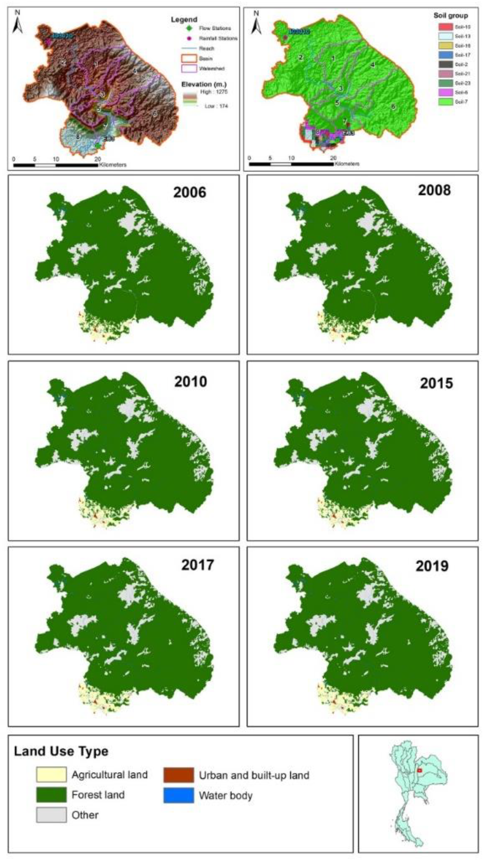
The Lam Saphung River Basin has 1 rain gauge station at location, 403010 (see Figure 4). Rain data was used to estimate runoff and rainfall on flooding by considering flash floods for the year 2021. The rainfall records in 2006-2021 are shown in Figure 3. It can be seen that the highest rainfall occurred in 2006 and the least amount of rain occurred in 2019. Figure 4 shows the location of runoff measurement at E.83. The topography is an area of high mountains and a plain in the middle around the elevated watershed. There are 9 groups of soil series, most of which are found in river basins of Soil-7. One group of soil series that were formed from soil parent material such as river sediments was in the area of the sedimentary plains which where water logged during the rainy season. The soil is very deep with. relatively poor to poor drainage. The topsoil is clay and clay loam. The bottom soil is clay. The 5 main land use types of this area are shown in Figure 4; the most common type of land use is forest area. In addition, the land use of Lam Saphung River Basin is shown on the land use map from 2006-2019.
Figure 3.
The highest daily rainfall in the water years 2006-2021 in the Lam Saphung River Basin.
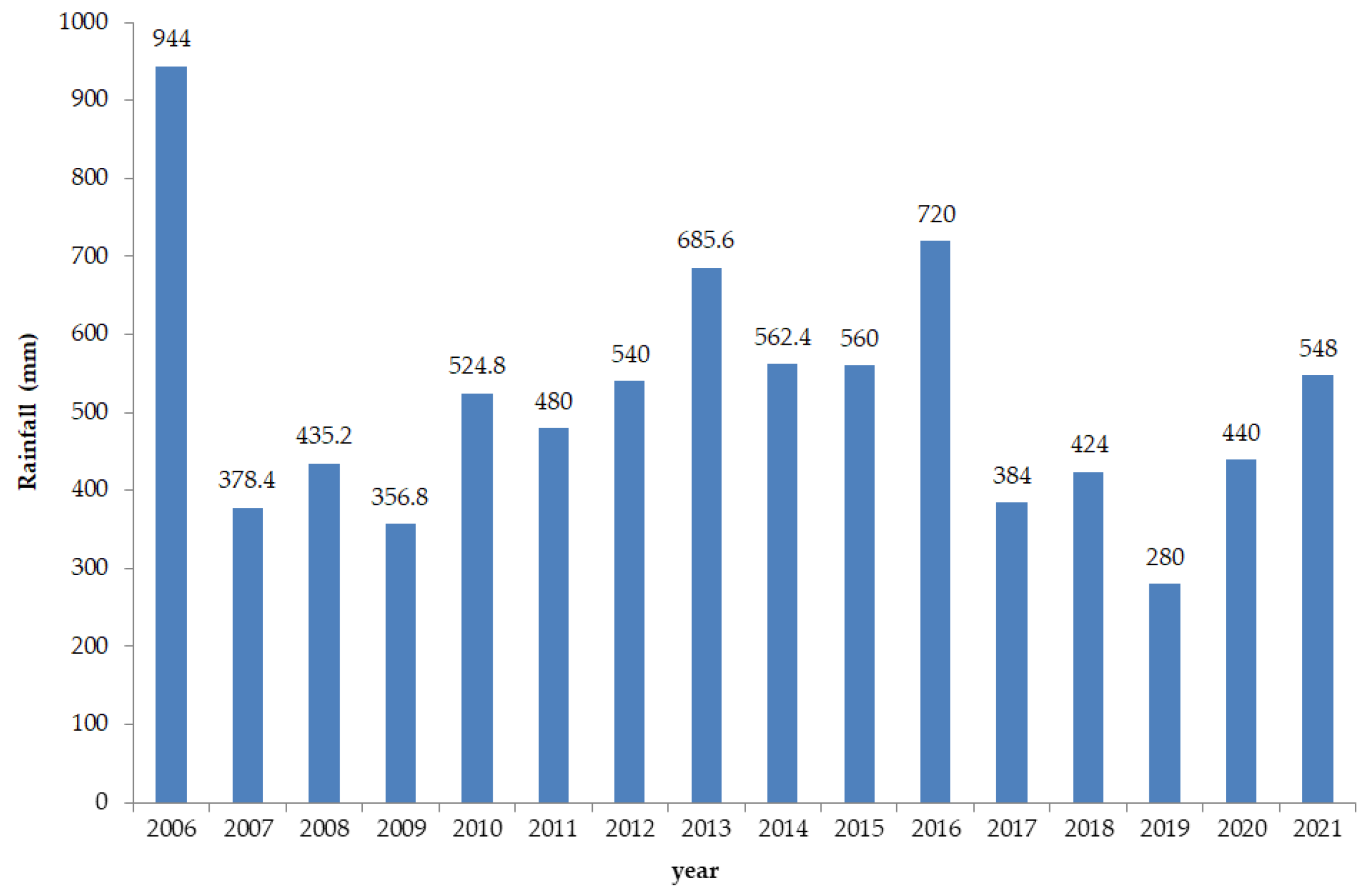
Figure 4.
Digital elevation model (DEM), soil series map, and land use maps of representative area 1, which is in the Lam Saphung River Basin.
Figure 4.
Digital elevation model (DEM), soil series map, and land use maps of representative area 1, which is in the Lam Saphung River Basin.
2.2.2. Information on the Phrom River Basin
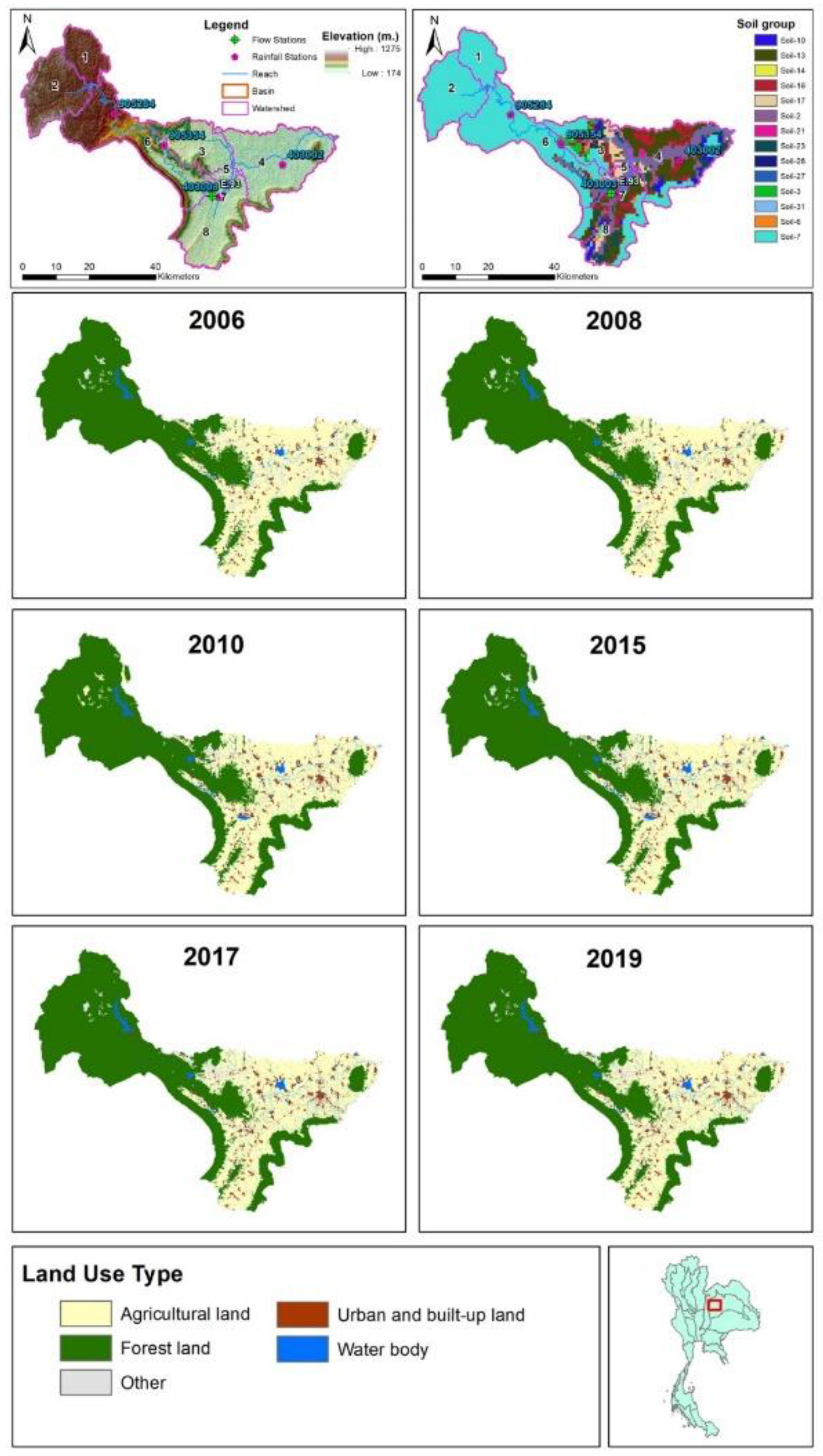
The Phrom River Basin has four rain gauge stations: 403002, 403003, 905354, and 905824 (as shown in Figure 6). The rainfall data were used to estimate the impact of rainfall on flooding by considering flash flooding in the year 2021. The rainfall data in 2006-2021 are shown in Figure 5. It can be seen that the highest rainfall occurred in 2006 and the least amount of rain occurred in 2019. Figure 6 shows the location of 1 runoff measurement location, E.93, which has the topographical characteristics of the area adjacent to the Lam Saphung, the upper Lam Chi River basins, the Lam Nam Chern branch basin, the Lam Chi River Section 2 and the area of the upper Nam Phrom River above Chulabhorn Dam. There are 14 groups of soil series, most of which are found in river basins of Soil-7 that formed from soil parent material such as river sediments. These soils are found in the area of the sedimentary plains that are waterlogged during the rainy season. It is very deep soil with. relatively poor to poor drainage. The topsoil texture is clay and clay loam. The bottom soil texture is clay and constitutes the soil present in the 5 main types of land use areas. However, the most common type of land use is forest area.
Figure 5.
The highest daily rainfall in the water years 2006-2021 of the Phrom River Basin.

Figure 6.
Digital elevation model (DEM), soil series map, and land use maps of representative area 2, which is the Phrom River Basin.
Figure 6.
Digital elevation model (DEM), soil series map, and land use maps of representative area 2, which is the Phrom River Basin.
2.2.3. Information on the Chern River Basin Part 1
Chern River Basin Part 1 has five rain gauge stations: 379028, 381003, 041302, 041302, and 041307 (as shown in Figure 8). The rainfall data were used to estimate the impact of rainfall on flooding by considering flash flooding in year 2021 and rainfall in 2006-2021 as shown in Figure 7. It can be seen that the highest rainfall occurred in 2006 and the least amount of rain occurred in 2019. Figure 8 shows the location of 1 runoff measurement location (E.85) and more than 50 % of the watershed's topography comprises steep mountains and dense forests interspersed with low hills. There are 19 groups of soil series, most of which are Soil-7. The most common type of land use is forest area.
Figure 7.
The maximum daily rainfall in the water years 2006-2021 of the Chern River Basin, Part 1.
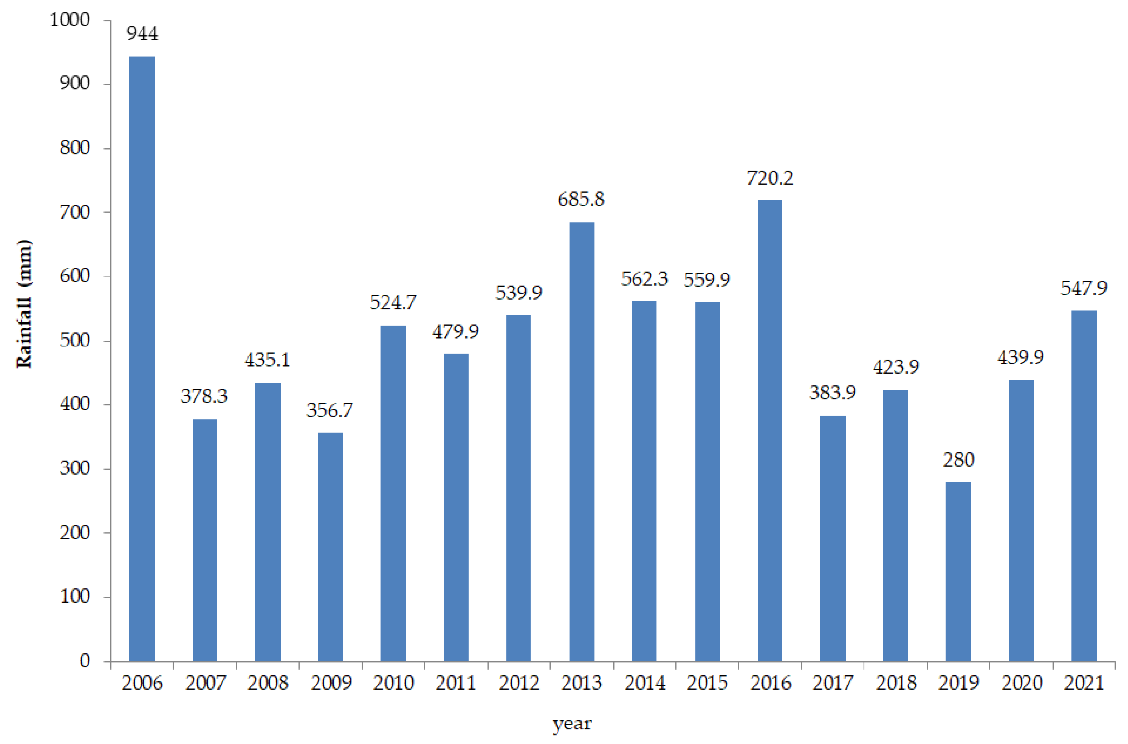
Figure 8.
Digital elevation model (DEM), soil series map, and land use maps from 2006-2021 of representative area 3 of the Chern Basin Part 1.
Figure 8.
Digital elevation model (DEM), soil series map, and land use maps from 2006-2021 of representative area 3 of the Chern Basin Part 1.
The soil levels of each area are shown in Figure 4, Figure 6, and Figure 8 for the Lam Saphung River Basin, the Phrom River Basin and the Chern Basin Part 1 respectively. These provide important information for input data affecting to runoff data. In addition, the soil series maps and the land use maps are shown in terms of changes from past to recent years. A change in land use, such as changing from forestland to agriculture or building a city, affects the drainage process and flooding. The changes in land use and rainfall influence runoff data. The consideration of changing rainfall data will help to understand how rainfall distribution patterns affect to stream flow in the basin.
The types of land use changes in the three river basins are summarized in Table 2. From the table, it that the Phrom River Basin has a total area of 2,263.8 km2 (square kilometers) over which. increases were mainly in agricultural and other areas. Forestry decreased, accounting for the greatest proportion of land use changes from forest to residential areas from 2008 to 2010. the Chern River Basin Part 1 has a total area of 1,898.5 km2 and has. the lowest proportion of land use change from forest area to residential area is the Lam Saphung River Basin with a total area of 743.4 km2. Agricultural areas comprised the greatest increase in land use.
2.3. Estimating Runoff Scenarios
This research evaluated runoff from three simulated situations. (1) influence of changes in land use to runoff, (2) influence of changes in rainfall to runoff, and (3) influence of changes in the proportion of land use to runoff. The procedure for each situation is described as follows.
2.3.1. Changes in Land Use to Runoff Volume
The effect of land use change on runoff was evaluated using the watershed areas selected for having been affected by flash floods in Thailand during 2021. This study considered only 3 areas, as described in the previous section. The selected land use maps for 2006, 2008, 2010, 2015, 2017 and 2019 were used for each run with the same rainfall data for the year 2021 in each case. Therefore, the 2019 land use map was used as the baseline data for comparing changes in land use affecting runoff data. In this study, data on land use changes in various years was used with the rainfall data from the year in which the flash flood occurred. When running the SWAT model according to various simulation situations, the amount of runoff in different years according to the selected land use map was obtained. The procedure is shown in Figure 9. The runoff data of each selected area was then recorded.
2.3.2. Changes in Rainfall in Relation to Runoff
The changes in rainfall data to runoff volume were investigated similarly to Section 2.3.1 by using land use maps only in the year 2021 with the various rainfall data as shown in Figure 10. The selected land use areas of this study were treated similarly using rainfall changes for 2006, 2008, 2010, 2015, 2017 and 2019. The procedure of each selected area was performed, the runoff output was obtained and recorded.
2.3.3. Changes in the Proportion of Land Use in Relation to Maximum Runoff
Changes in the proportion of land use in relation to maximum runoff volume were investigated by using the procedure described in Section 2.3.1. The constant rainfall data was used only in the least rainfall year (2019) whereas land use maps were used from various years. The runoff volume was obtained from each run of SWAT. The trend of land use change and the maximum runoff volume was analyzed.
3. Results and Discussions
The results of the study are presented in 4 parts. (1) the efficiency of the SWAT model, (2) the effect of changes in land use on the amount of runoff, (3) the effect of changes in the amount of rainfall on the amount of runoff, and (4) the change in the proportion of land use to the maximum of runoff. The details of each part are presented below.
3.1. SWAT Model Performance Results
Adjusting the parameters in SWAT model is an essential procedure for evaluating the accuracy and reliability of the model before using it to simulate any scenarios. This step helps the model correspond to the real situation, increase efficiency and confidence in the runoff results.
3.1.1. Appropriate Parameters
This study used SWAT-CUP to analyze the sensitivity of 8 important parameters during flooding. The results from SWAT-CUP over 500 simulation rounds are shown in Table 3. It was found that the results were close to the actual data from water measuring stations E83, E93 and E85 in 2021. The SWAT model was used to analyze runoff data both during of the dry season to the rainy season and during of the rainy season to the dry season with acceptable criteria for all 3 selected areas. As shown in Table 3, (which reports the statistical indices of the inspection for the period October–December 2021), the SWAT-CUP makes it possible to identify appropriate parameters. It had good performance in predicting runoff volume in all 3 river basins.
In addition, the various parameters that affect the realism of the model were studied. It was found that the parameter with the greatest effect on the model was Gwqmn, which is the variable that has a notable impact on the drainage process in the watershed that is the objective of this study. The adjustment of Gwqmn value can have a significant impact on the simulated water behavior in the basin. These parameters Gw_Revap and Alpha_Bf were also important in communicating information related to drainage processes and rainfall distribution in the basin. The Gw_Revap watershed has a low P-Value and a high T-Stat. It shows a relationship that is statistically significant and has an effect on the model. Similarly, Alpha_Bf is a parameter that has a significant impact on the model due to its low P-Value and high T-Stat. Therefore, adjusting Gwqmn, Gw_Revap and Alpha_Bf are important steps in model adjustments, a reported in previous studies [49,50,51]. The SWAT-CUP model adjusted in this study achieved simulation results that were most consistent with realistic water behavior in the three representative basins.
3.1.2. Calibration and Validation
The calibration and calibration of the model to check its accuracy considers statistical values, including the Coefficient of Determination (R2), the Root Mean Square Error (RMSE), Percent Bias of Estimation (PBIAS) and Nash Suttclife coefficient (Nash-Suttclife efficiency, NSE) according to Equations 1–4 [52,53]and the results are shown in Table 4.
From Table 4, it is found that the Lam Saphung River Basin's total annual runoff volume was 4,152.89 m3 (cubic meters), 22.7% lower than station E83, with SWAT-CUP giving good results (R2=0.84, PBIAS=40.80%, RMSE= 15.61 and NSE=0.654). For the Nam Prom Basin, the total annual runoff was 6,080.56 m3, 20.1% higher than station E93, also with good results of R2=0.88, PBIAS=5.31%, RMSE=7.95 and NSE= 0.874. For the Chern River Basin Section 1, the total annual runoff volume was 7,391.60 m3, 23.9% higher than station E85 with the good results of R2=0.79, PBIAS=10.62%, RMSE=15.37and NSE=0.783. The relationships between the stream from record and the runoff from simulation model are shown in Figure 11.
Figure 11 allows, the comparison of results between the runoff estimation and the flow record in 2021 at measurement stations E.83, E.93, and E. 85. It also presents the values for R2 and PBIAS. indicating that calibration of the data over a period of approximately 1 year between the simulation and real data revealed a consistent correlation of 74.9% between the two datasets, while validation provided an additional 24.1%. The accuracy and reliability of simulation results are acceptable for both flood and drought events in 2021. In addition, the selection of the time period during calibration and verification is very important in order to extract standardized data from the combined stream flow records and adapt them to the simulation results. This information provides a useful database to evaluate the reliability of the simulations and the validity of the results of the flow correlation results from the two data sources according to previous studies [47,48,52,53].
3.2. Effects of Land Use Changes on Runoff Volume
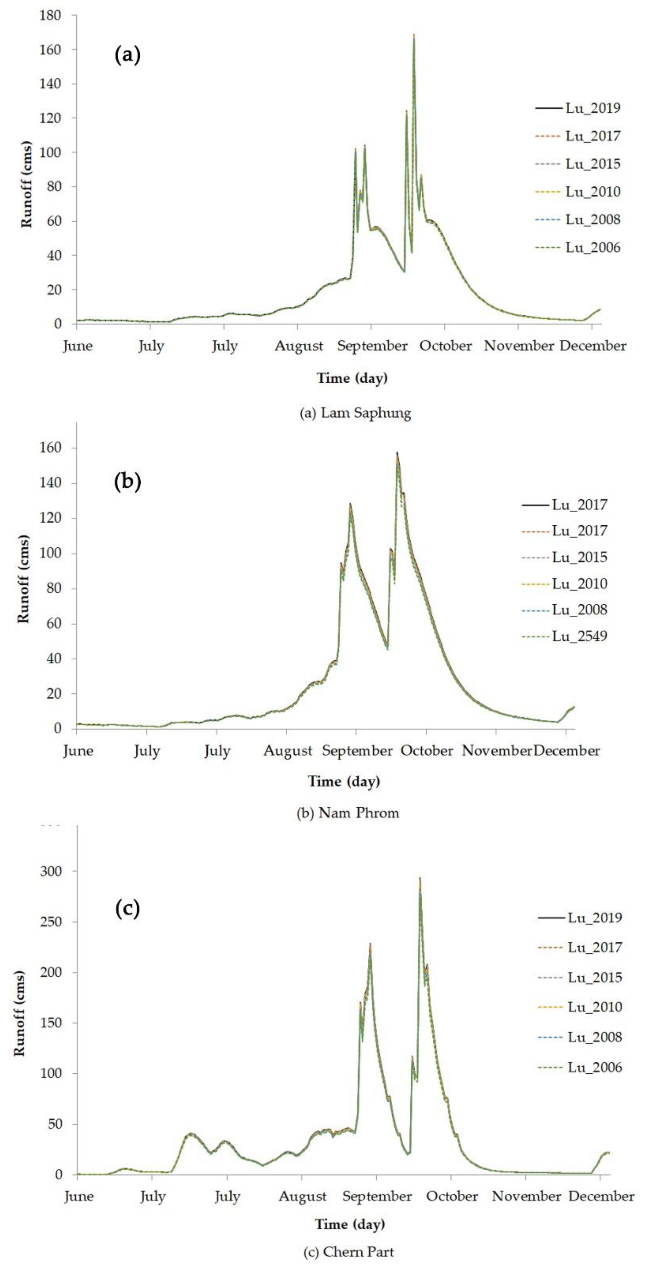
Table 5 shows the maximum runoff volume of selected study areas when considering rainfall data in 2021 only with the various land use maps in 2006, 2008, 2010, 2015, 2017 and 2019. The results indicate that the highest runoff event was on 10 October for all selected areas. There was a maximum runoff of 169.3, 169.1, 169.1, 168.7, 168.0, and 168.0 m3 for land use years 2019, 2017, 2015, 2010, 2008 and 2006 respectively for the Phrom River Basin. The maximum runoff volumes of the Nam Prom Basin were 157.5, 156.6, 156.1, 156.0, 154.8 and 154.8 for land use years 2019, 2017, 2015, 2010, 2008 and 2006 respectively. For the Chern River Basin Part 1, the highest value was in the year 2019 of 299.0 m3 whereas the lowest was in 2006 of 293.3 m3. These results are plotted in Figure 12.
From Figure 12, it can be seen that the highest runoff in all 3 selected river basins was also caused by land use in 2019, which is the most recent data for land use. In all 3 selected river basins, it was found that the maximum runoff volume tended to steadily increase from 2006 to 2019, with all values being similar. There was little difference in peak runoff volumes from 2006 to 2019. The highest maximum runoff value was from the Chern River Basin Part 1. In addition, it was found that the highest occurrence of runoff happened in 2 periods; September (dry season — flood season) and October (flood season — dry season) of every land use year in all 3 river basins, as previously reported [43,54,55,56]. Therefore, it can be concluded that recent land use changes under the highest annual rainfall will cause the basin's highest runoff.
Figure 12.
The estimation runoff when using rainfall data only in 2021 and land use maps in various years for the Lam Saphung (a), Nam Phrom (b) and Chern Part 1 (c).
Figure 12.
The estimation runoff when using rainfall data only in 2021 and land use maps in various years for the Lam Saphung (a), Nam Phrom (b) and Chern Part 1 (c).
3.3. Effects of Changes in Rainfall on Runoff Volume
Table 6 shows the highest runoff volume of the Lam Saphung Basin, Phrom Basin, and Chern River Basin Part 1 when only using land use maps for 2021 with the rainfall data from various years. It was found that the maximum runoff volumes of all selected study areas occurred in 2010. The highest maximum runoff value (498.2 m3) was from the Chern River Basin Part 1. Figure 13 shows daily runoff of the Lam Saphung Basin, Phrom Basin, and Chern Basin Part 1 when using land use maps for 2021 with the rainfall data in various years of 2006, 2008, 2010, 2015, 2017 and 2019. It can be seen that when using the latest year land use maps (2021) and rainfall in 2010, the highest runoff volumes were obtained for all selected areas. Therefore, it can be concluded that the current land use with more rainfall data can provide the highest maximum runoff volumes under the same situation reported for most river basins according to previous studies [57,58,59].
3.4. Results of Changes in the Proportion of Land Use Affecting to Maximum Runoff
Figure 7 shows the residential land use size from years 2006, 2008, 2010, 2015, 2017 and 2019 of the Lam Saphung Basin, Phrom Basin, and Chern Basin Part 1. Figure 14 also shows the percentage change rate for residential land use types as compared with the base line year of 2006. The results show that the highest rate was from 2008 to 2010 for the Lam Saphung Basin and the Nam Prom Basin, whereas the high rate of Chern Part 1 occurred from 2008 to 2015 as compared with the base line of 2006. These land use types had been changed from forest areas to residential areas, especially in 2 river basins (Phrom River Basin, from 51.3 increased by 61.0 km2 (18.9%) and the Lam Saphung Basin from 1.1 increased by 1.3 km2 (18.2%) as compared to the base line year of 2006). The results also indicated that the proportion of changes in land use types from forest areas to residential areas has clearly increased in some years, especially in 2008 and 2010. These changes will have directly affected the maximum runoff volume. Therefore, it can be concluded that a higher proportion of land use change will result in higher runoff.

Table 7.
The area sizes of residential land use types for the Lam Saphung Basin, Phrom Basin, and Chern Basin Part 1.
Table 7.
The area sizes of residential land use types for the Lam Saphung Basin, Phrom Basin, and Chern Basin Part 1.
| Watershed | Land use area (km2) | |||||
| 2006 | 2008 | 2010 | 2015 | 2017 | 2019 | |
| Lam Saphung | 1.1 | 1.1 | 1.3 | 1.3 | 1.3 | 1.3 |
| Nam Phrom | 51.3 | 51.33 | 61.0 | 61.2 | 65.0 | 68.0 |
| Chern Part 1 | 90.4 | 90.3 | 98.1 | 105.5 | 109.5 | 115.5 |
Table 8 shows the maximum runoff volumes when using the least rainfall year (2019) with the various land use maps for the years 2006, 2008, 2010, 2015, 2017 and 2019. The results indicated that the high changes of maximum runoff occurred from year 2008 to 2010 for all selected study areas. Figure 15 show the percentage of maximum runoff changes as compared with the base line year of 2006 when using the least rainfall year (2019) with the various land use maps of 2006, 2008, 2010, 2015, 2017 and 2019. The data indicate high percentage changes of maximum runoff occurred from year 2008 to 2010 for all selected study areas. In addition, the highest percentage change was 77.8% for the Lam Saphung River Basin whereas the lowest percent change was 7.3% for the Chern Basin Part 1. Therefore, it can be concluded that the proportion of the increase in runoff volume was a result of changes in land use from forerst area to residential area and this result agrees with previous studies [60,61,62,63].
4. Conclusions
This research article presents the application of the SWAT model to assess runoff in areas with a history of flash floods. Three areas that had previously experienced flash floods were selected as the case study, namely the Lam Saphung Basin, the Phrom River Basin, and the Chern River Basin Part 1, which is a subbasin of the Chi River in Thailand. There were 3 objectives of this study. The first was to assess the effectiveness of the SWAT model in assessing runoff in areas that have experienced flash floods. The second was to analyze the factors that influence the amount of runoff especially with regard to changes in rainfall and land use. Finally, the proportion of land use change affecting the maximum runoff volume was analyzed. Three simulation scenarios were employed. : (1) A scenario of land use change affecting runoff volume by using constant rainfall data only in the year 2021 and considering land use changes from land use maps in 2006, 2008, 2010, 2015, 2017, 2019 and 2021.; (2) A scenario of rainfall change affecting runoff using constant land use data only in 2021 and considering rainfall in 2006, 2008, 2010, 2015, 2017, 2019 and 2021; (3) A scenario of changes in the proportion of land use to runoff using constant rainfall data in the year with the least rainfall of 2019, and considering land use changes from land use maps in 2006, 2008, 2010, 2015, 2017, 2019, and 2021.
It was found that the application of the SWAT model produced highly reliable results that could be applied to estimate annual runoff in areas that have experienced flash floods. It was also shown that 8 parameters were effective condition, all with R2 values of 0.74, 0.82, and 0.74 for the Lam Saphung Basin, Phrom River Basin, and Chern River Basin Part 1 respectively. In addition, the analysis found that land use changes in 2019 (which was the latest year studied), influenced the maximum runoff volume in all 3 areas which was 169.3, 157.5, and 299.8 m3/s (cubic meters/second) respectively. When considering changes in rainfall volume and constant land use, it was found that the highest rainfall in 2010 also had the greatest impact on the runoff volume in all 3 areas. In addition, it was found that the proportion of land use changes involving changes from forest areas to residential areas was the greatest from 2008 to 2010 in the Phrom River Basin and Chern River Basin Part 1, which would have resulted in the maximum runoff volume increasing by 77.78% and 46.87 % respectively as compared to year 2006. It can be concluded that the maximum amount of rain in each area affected the maximum amount of runoff. . Also a high proportion of changes in land use from forest to residential areas affected the maximum runoff volume in the basin. For improved accuracy and a more detailed characterization of runoff, future studies should consider hourly rainfall data.
Author Contributions
Conceptualization, L.S. and A.K.; methodology, L.S.; validation, L.S., and A.K.; formal analysis, L.S.; investigation, L.S.; resources, L.S.; data curation, L.S.; writing—original draft preparation, L.S. and A.K.; writing—review and editing, L.S., K.S., O.S. and A.K.; visualization, L.S.; supervision, A.K.; project administration, A.K.; funding acquisition, A.K. All authors have read and agreed to the published version of the manuscript.
Funding
This research was financially supported by Mahasarakham University.
Data Availability Statement
The data used to support the findings of this study are available from the corresponding author upon request.
Acknowledgments
The author would like to appreciate the Mahasarakham University and the Land Development Department, the Meteorological Department and the Royal Irrigation Department for supporting information, tools, and research units.
Conflicts of Interest
The authors declare no conflict of interest.
References
- Behzad, Asadieh., Nir, Y., Krakauer. (2017). Global change in flood and drought intensities under climate change in the 21 st century. Hydrology and Earth System Sciences Discussions. [CrossRef]
- Zbigniew, W., Kundzewicz., Maciej, Radziejewski., Iwona, Pińskwar. (2006). Precipitation extremes in the changing climate of Europe. Climate Research. [CrossRef]
- Hayley, J., Fowler., Haider, Ali. (2022). Analysis of extreme rainfall events under the climatic change. [CrossRef]
- Jie, He., Puyu, Feng., Bin, Wang., Wei, Zhang., Yongqiang, Zhang., De, Li, Liu., James, Cleverly., Alfredo, Huete., Qiang, Yu. (2022). Centennial annual rainfall pattern changes show an increasing trend with higher variation over Northern Australia. Journal of Hydrometeorology. [CrossRef]
- Conrad, Wasko., Rory, Nathan., Lina, Stein., Declan, O'Shea. (2021). Evidence of shorter more extreme rainfalls and increased flood variability under climate change. Journal of Hydrology. [CrossRef]
- Zbigniew, W., Kundzewicz., Jacek, A., Jania. (2007). Extreme hydro-meteorological events and their impacts.From the global down to the regional scale.
- Matthias, Ruth., María, Eugenia, Ibarrarán. (2009). Distributional Impacts of Climate Change and Disasters. Research Papers in Economics. [CrossRef]
- Alberto, Viglione., Magdalena, Rogger. (2015). Flood Processes and Hazards. [CrossRef]
- Amanda, J., Schroeder., Jonathan, J., Gourley., Jill, Hardy., Jen, Henderson., Pradipta, Parhi., Vahid, Rahmani., Kimberly, A., Reed., Russ, S., Schumacher., Brianne, K., Smith., Matthew, J., Taraldsen. (2016). The development of a flash flood severity index. Journal of Hydrology. [CrossRef]
- Lynn, Donelson, Wright., Christopher, F., D'Elia., C., Reid, Nichols. (2019). Impacts of Coastal Waters and Flooding on Human Health. [CrossRef]
- Xiekang, Wang., Changjun, Liu. (2023). Flash Floods: Forecasting, Monitoring and Mitigation Strategies. Water. [CrossRef]
- Ilhem, Hadjij., Miloud, Sardou., Hanifi, Missoum., Said, Maouche. (2021). Flood-related deaths in Northwestern Algeria from 1966 to 2019. Arabian Journal of Geosciences. [CrossRef]
- Harold, E., Brooks., David, J., Stensrud. (2000). Climatology of Heavy Rain Events in the United States from Hourly Precipi-tation Observations. Monthly Weather Review. [CrossRef]
- Matthew, C., Larsen. (2008). Rainfall-triggered landslides, anthropogenic hazards, and mitigation strategies. Advances in Geosciences. [CrossRef]
- Petr, Rapant., Tomáš, Inspektor., Jaromír, Kolejka., Katenna, Batelkova., Jana, Zapletalová., Karel, Kirchner., Tomáš, Krejčí. (2015). Early warning of flash floods based on the weather radar. [CrossRef]
- Kevin, Sene. (2012). Flash Floods: Forecasting and Warning.
- Hidayah, Basri., Syakur, Syakur., Azmeri, Azmeri., Eldina, Fatimah. (2022). Floods and their problems: Land uses and soil types perspectives. IOP conference series. [CrossRef]
- Adam, Rusinko., Šárka, Horáčková. (2022). Flash flood simulation in the urbanised catchment: a case study of Bratislava-Karlova Ves. Geographia Cassoviensis. [CrossRef]
- Jakob, Zscheischler., Oldrich, Rakovec., Jiang, Shijie., Attila, Joó. (2023). Identifying drivers of river floods using causal infer-ence. [CrossRef]
- Safwat, Gabr., Ibrahim, Alkhaldy., Waleed, A., El-Saoud., Turki, M., Habeebullah. (2021). Flash flood modeling and mitigation of Al-Hussainiyah area, Makkah, Saudi Arabia. Arabian Journal of Geosciences. [CrossRef]
- Liudmila, Kuksina., Valentin, Golosov., Yu., S., Kuznetsova. (2017). Cloudburst floods in mountains: State of knowledge, occurrence, factors of formation. Geography and Natural Resources. [CrossRef]
- Sayed, Mosaad. (2017). Geomorphologic and geologic overview for water resources development: Kharit basin, Eastern Desert, Egypt. Journal of African Earth Sciences. [CrossRef]
- Ligal, Sebastian. (2022). Flood control through structural and non-structural amplification approaches. Jurnal Teknik Sipil. [CrossRef]
- Endang, Savitri., Rahardyan, Nugroho, Adi., Pamungkas, Buana, Putra., Yonky, Indrajaya. (2022). WATERSHED MAN-AGEMENT APPROACH AS AN ALTERNATIVE SOLUTION FOR FLOOD PROBLEM IN NORTHERN PART OF CENTRAL JAVA (Pendekatan Pengelolaan DAS Sebagai Alternatif Solusi Masalah Banjir di Jawa Tengah Utara). Jurnal penelitian pengelolaan daerah aliran sungai (Journal of watershed management research). [CrossRef]
- Amadou, Angelina., Abdouramane, Gado, Djibo., Ousmane, Seidou., Ibrah, Seidou, Sanda., Ketvara, Sittichok. (2015). Changes to flow regime on the Niger River at Koulikoro under a changing climate. Hydrological Sciences Journal-journal Des Sciences Hydrologiques. [CrossRef]
- Ying, Liu., Yuxia, Xu., Yaqian, Zhao., Yan, Long. (2022). Using SWAT Model to Assess the Impacts of Land Use and Climate Changes on Flood in the Upper Weihe River, China. Water. [CrossRef]
- Laurie, Boithias., Sabine, Sauvage., Anneli, Lenica., Hélène, Roux., Karim, C., Abbaspour., Kévin, Larnier., Denis, Dartus., José-Miguel, Sánchez-Pérez. (2017). Simulating Flash Floods at Hourly Time-Step Using the SWAT Model. Water. [CrossRef]
- Lanhua, Luo., Qing, Zhou., Hong, S., He., Liangxia, Duan., Gaoling, Zhang., Hongxia, Xie. (2020). Relative Importance of Land Use and Climate Change on Hydrology in Agricultural Watershed of Southern China. Sustainability. [CrossRef]
- virasith, phomsouvanh., Vannaphone, Phetpaseuth., Soo, Jin, Park. (2016). Study on Climate Change Impacts on Hydrological Response using a SWAT model in the Xe Bang Fai River Basin, Lao People’s Democratic Republic.
- Sherly, Shelton. (2021). Evaluation of the Streamflow Simulation by SWAT Model for Selected Catchments in Mahaweli River Basin, Sri Lanka. [CrossRef]
- Fubo, Zhao., Yiping, Wu., Linjing, Qiu., Yuzhu, Sun., Liqun, Sun., Qinglan, Li., Jun, Niu., Guoqing, Wang. (2018). Parameter Uncertainty Analysis of the SWAT Model in a Mountain-Loess Transitional Watershed on the Chinese Loess Plateau. Water. [CrossRef]
- Rafael, Alvarenga, Almeida., Silvio, Bueno, Pereira., Daniel, Brasil, Ferreira, Pinto. (2018). Calibration and validation of the swat hydrological model for the mucuri river basin. Engenharia Agricola. [CrossRef]
- Cong, Xiao., Kiyosi, Kawanisi., Mohamad, Basel, Al, Sawaf., Xiaopan, Zhu. (2023). Assessment of flood dynamics in a mountain stream using high-resolution river flow records. Hydrological Processes. [CrossRef]
- Muhammad, Jehanzaib., Mohammad, Ajmal., Mohammed, Achite., Tae-Woong, Kim. (2022). Comprehensive Review: Ad-vancements in Rainfall-Runoff Modelling for Flood Mitigation. Climate. [CrossRef]
- V., Anselmo., Giorgio, Galeati., S., Palmieri., U., Rossi., E., Todini. (1996). Flood risk assessment using an integrated hydrological and hydraulic modelling approach: a case study. Journal of Hydrology. [CrossRef]
- Keighobad, Jafarzadegan., Hamid, Moradkhani., Florian, Pappenberger., Hamed, Moftakhari., Paul, D., Bates., Peyman, Abbaszadeh., Reza, Marsooli., Celso, M., Ferreira., Hannah, Cloke., Fred, L., Ogden., Qingyun, Duan. (2023). Recent Advances and New Frontiers in Riverine and Coastal Flood Modeling. Reviews of Geophysics. [CrossRef]
- D., De, Wrachien., Stefano, Mambretti. (2011). Mathematical Models In Flood Management:Overview, Laboratory Tests And Case Study. WIT Transactions on State-of-the-art in Science and Engineering. [CrossRef]
- Daniela, Falter., Kai, Schröter., Nguyen, Viet, Dung., Sergiy, Vorogushyn., Heidi, Kreibich., Yeshewatesfa, Hundecha., Heiko, Apel., Bruno, Merz. (2015). Spatially coherent flood risk assessment based on long-term continuous simulation with a coupled model chain. Journal of Hydrology. [CrossRef]
- Rui, Xu., Dexun, Qiu., Chang-wen, Wu., Xingmin, Mu., Guangju, Zhao., Wenyi, Sun., Peng, Gao. (2023). Quantifying climate and anthropogenic impacts on runoff using the SWAT model, a Budyko-based approach and empirical methods. Hydrological Sciences Journal-journal Des Sciences Hydrologiques. [CrossRef]
- Mojtaba, Khoshravesh., Reza, Norooz, Valashedi. (2023). Assessing the effect of climate and land use changes on the hydrologic regimes in the upstream of Tajan river basin using SWAT model. Applied Water Science. [CrossRef]
- Roland, Yonaba., Lawani, Adjadi, Mounirou., Fowe, Tazen., Mahamadou, Koïta., A., Biaou., Cheick, Oumar, Zouré., Pierre, Queloz., Harouna, Karambiri., Hamma, Yacouba. (2023). Future climate or land use? Attribution of changes in surface runoff in a typical Sahelian landscape. Comptes Rendus Geoscience. [CrossRef]
- S., K., Verma., A., D., Prasad., M., K., Verma. (2022). An Assessment of Ongoing Developments in Water Resources Man-agement Incorporating SWAT Model: Overview and Perspectives. Nature Environment and Pollution Technology. [CrossRef]
- Haris, Prasanchum. (2023). Risk assessment of flash flood situation under land use change using daily SWAT streamflow simulation in Loei Basin, Northeastern, Thailand. IOP conference series. [CrossRef]
- Marcia, Chen., Marcio, Cataldi., Cristiane, Nunes, Francisco. (2023). Application of Hydrological Modeling Related to the 2011 Disaster in the Mountainous Region of Rio De Janeiro, Brazil. Climate. [CrossRef]
- Gebiyaw, Sitotaw, Takele., Geremew, Sahilu, Gebre., Azage, Gebreyohannes, Gebremariam., Agizew, Nigussie, Engida. (2021). Hydrological modeling in the Upper Blue Nile basin using soil and water analysis tool (SWAT). Modeling Earth Systems and Environment. [CrossRef]
- Waranyu, Buakhao., Anongrit, Kangrang. (2016). DEM Resolution Impact on the Estimation of the Physical Characteristics of Watersheds by Using SWAT. Advances in Civil Engineering, 2016:1-9. [CrossRef]
- A., D., Ávila., A., D., Ávila., Y., E., Carvajal., F., Justino. (2015). Representative rainfall thresholds for flash floods in the Cali river watershed, Colombia. [CrossRef]
- Olivier, Payrastre., Pierre-Alain, Ayral., Vincent, Barachet., V., Borell., Brice, Boudevillain., Christophe, Bouvier., Pascal, Brunet., C, Cantet., G., Coussot., A, Delrieu., J.F, Despax., M., Didon-Lescot., S, Domergue., S, Ecrepont., N., Froidurot., L.-R, Grard., G, Lagadec., R., Le, Bihan., Vinciane, Le, Boursicaud., P, Mansanarez., Pierre, Marchand., M.-L, Martin., A, Mosini., R, Mosset., L., Navas., S., Neppel., F., Perez., C., Raynaud., A., Saint-Martin. (2015). Hydrological post event survey after the autumn 2014 floods in the Cévennes region in France: results and first hydrological analyses.
- Mohd, Ayoub, Malik., Abdul, Qayoom, Dar., Manoj, Kumar, Jain. (2021). Modelling streamflow using the SWAT model and multi-site calibration utilizing SUFI-2 of SWAT-CUP model for high altitude catchments, NW Himalaya's. Modeling Earth Systems and Environment. [CrossRef]
- Kuan, Hung, Lin. (2020). Comparative analysis of swat cup and swatshare for calibrating swat models. [CrossRef]
- Duy, Liêm. (2013). Ứng dụng mô hình SWAT và công nghệ GIS đánh giá lưu lượng dòng chảy trên lưu vực sông Đắk Bla.
- Marcello, Benedini., George, Tsakiris. (2013). Model Calibration and Verification. [CrossRef]
- Mary, P., Anderson., William, W., Woessner., Randall, J., Hunt. (2015). Chapter 9 – Model Calibration: Assessing Performance. [CrossRef]
- Pengfei, Liang., Huijuan, Xin., Zongxing, Li. (2023). Quantifying the Contribution of Climate Change and Human Activities to Runoff Changes in the Source Region of the Yellow River. Polish Journal of Environmental Studies. [CrossRef]
- Ogden, F. L., Crouch, T. D., Stallard, R. F., & Hall, J. S. (2013). Effect of land cover and use on dry season river runoff, runoff efficiency, and peak storm runoff in the seasonal tropics of Central Panama. Water Resources Research, 49(12), 8443-8462. [CrossRef]
- Dai, Z., Du, J., Li, J., Li, W., & Chen, J. (2008). Runoff characteristics of the Changjiang River during 2006: Effect of extreme drought and the impounding of the Three Gorges Dam. Geophysical Research Letters, 35(7).
- Jabir, Haruna, Abdulkareem., Jabir, Haruna, Abdulkareem., Biswajeet, Pradhan., Wan, Nor, Azmin, Sulaiman., Nor, Roha-izah, Jamil. (2019). Long-term runoff dynamics assessment measured through land use/cover (LULC) changes in a tropical complex catchment. Environment Systems and Decisions. [CrossRef]
- Minmin, Zhou., Simin, Qu., Xueqiu, Chen., Peng, Shi., Shijin, Xu., Chen, Hongyu., Zhou, Huiyan., Gou, Jianfeng. (2019). Impact Assessments of Rainfall–Runoff Characteristics Response Based on Land Use Change via Hydrological Simulation. Water. [CrossRef]
- Meixiu, Yu., Qiongfang, Li., Xiaolong, Liu., Jianyun, Zhang. (2016). Quantifying the effect on flood regime of land-use pattern changes via hydrological simulation in the upper Huaihe River basin, China. Natural Hazards. [CrossRef]
- John, T, Harvey. (2023). Implementation of Zero Runoff to Reduce Runoff Discharges in Timbang Langsa Village, Langsa City. [CrossRef]
- Sitotaw, Haile, Erena., Hailu, Worku. (2019). Dynamics of land use land cover and resulting surface runoff management for environmental flood hazard mitigation: The case of Dire Daw city, Ethiopia. Journal of Hydrology: Regional Studies. [CrossRef]
- Majid, Mohammady., Hamid, Reza, Moradi., Hossein, Zeinivand., Arnaud, Temme., Mohammad, Reza, Yazdani., Hamid, Reza, Pourghasemi. (2018). Modeling and assessing the effects of land use changes on runoff generation with the CLUE-s and WetSpa models. Theoretical and Applied Climatology. [CrossRef]
- B., D., Dasanto., Risyanto. (2006). Evaluasi dampak perubahan penggunaan lahan terhadap volume limpasan studi kasus: das ciliwung hulu, jawa barat (evaluation of landuse change impact on run-off volume case study: ciliwung hulu watershed, west java). [CrossRef]
Figure 1.
Study Framework.
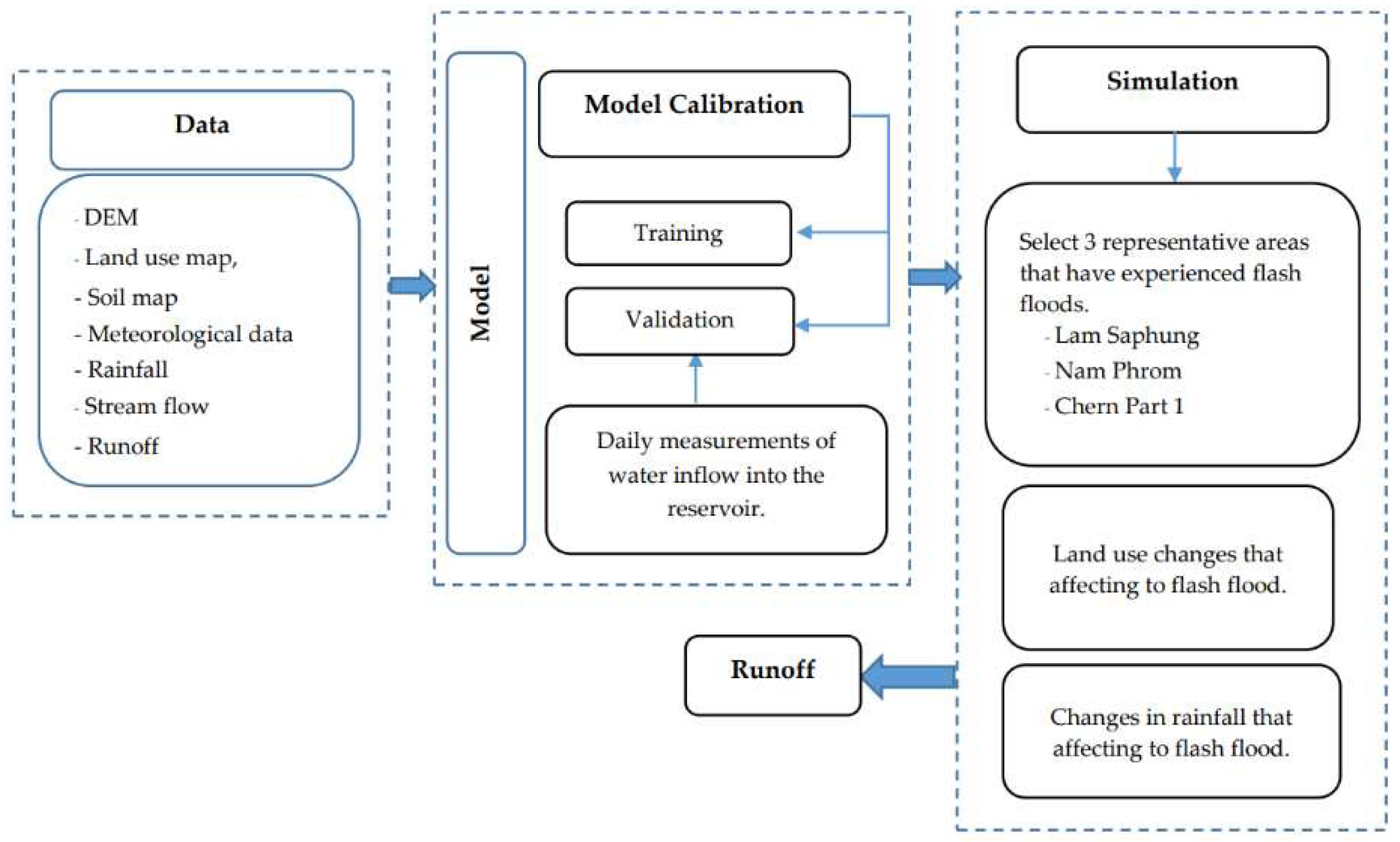
Figure 2.
Study area.
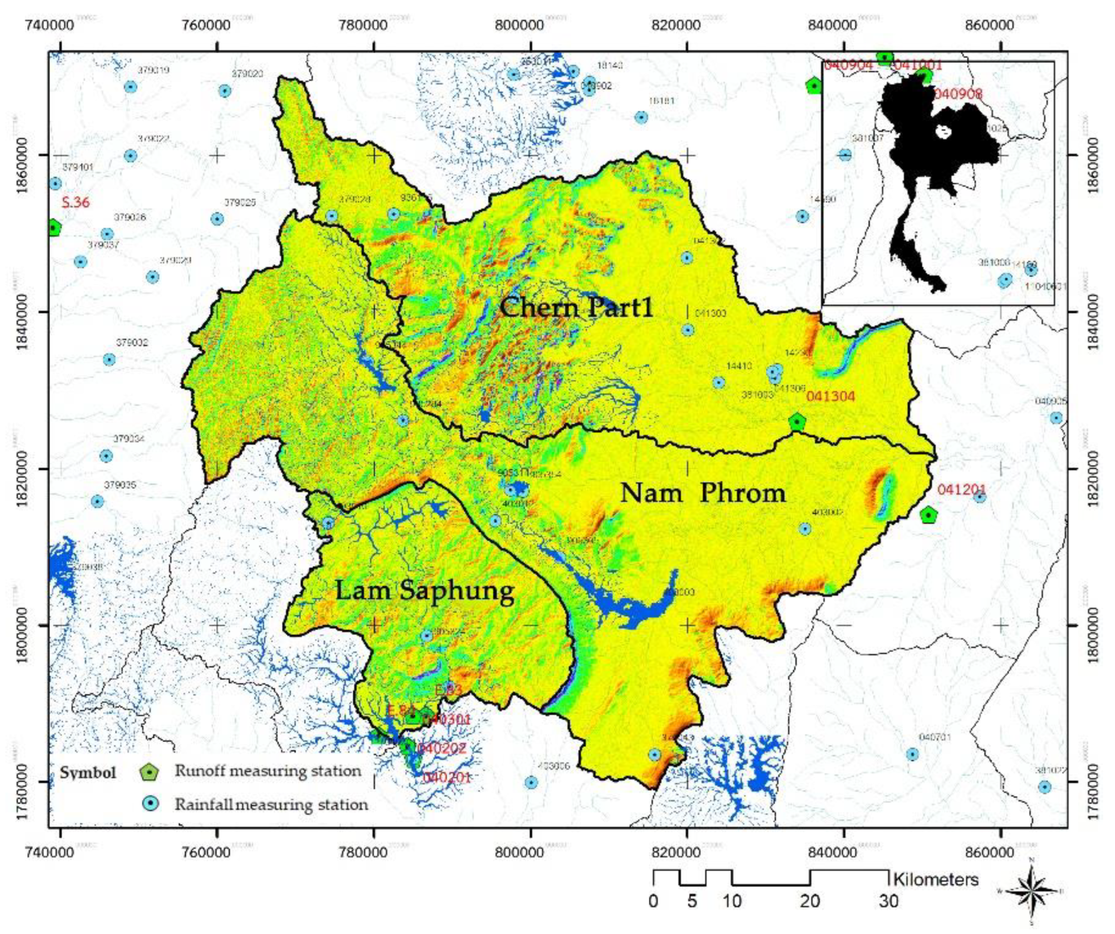
Figure 9.
Study framework on land use change affecting to runoff.
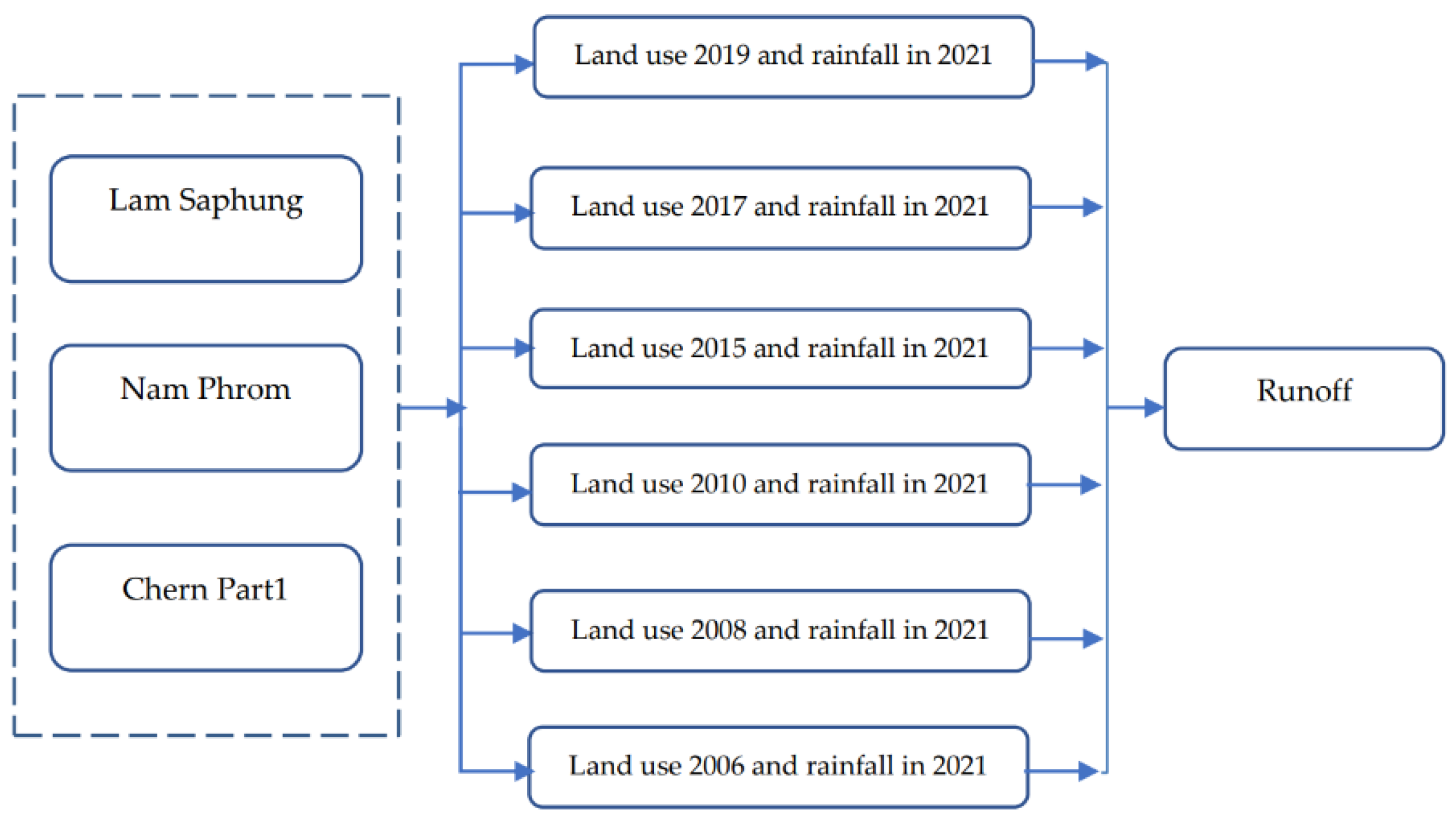
Figure 10.
Study framework on rainfall change affecting to runoff.
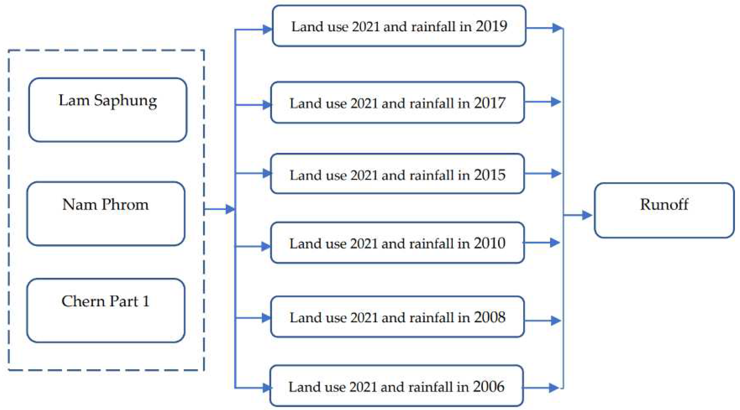
Figure 11.
The streamflow record and the estimation results in calibration and validation processes during year 2021 for the stations E.83 (a), E.93 (b) and E85 (c).
Figure 11.
The streamflow record and the estimation results in calibration and validation processes during year 2021 for the stations E.83 (a), E.93 (b) and E85 (c).
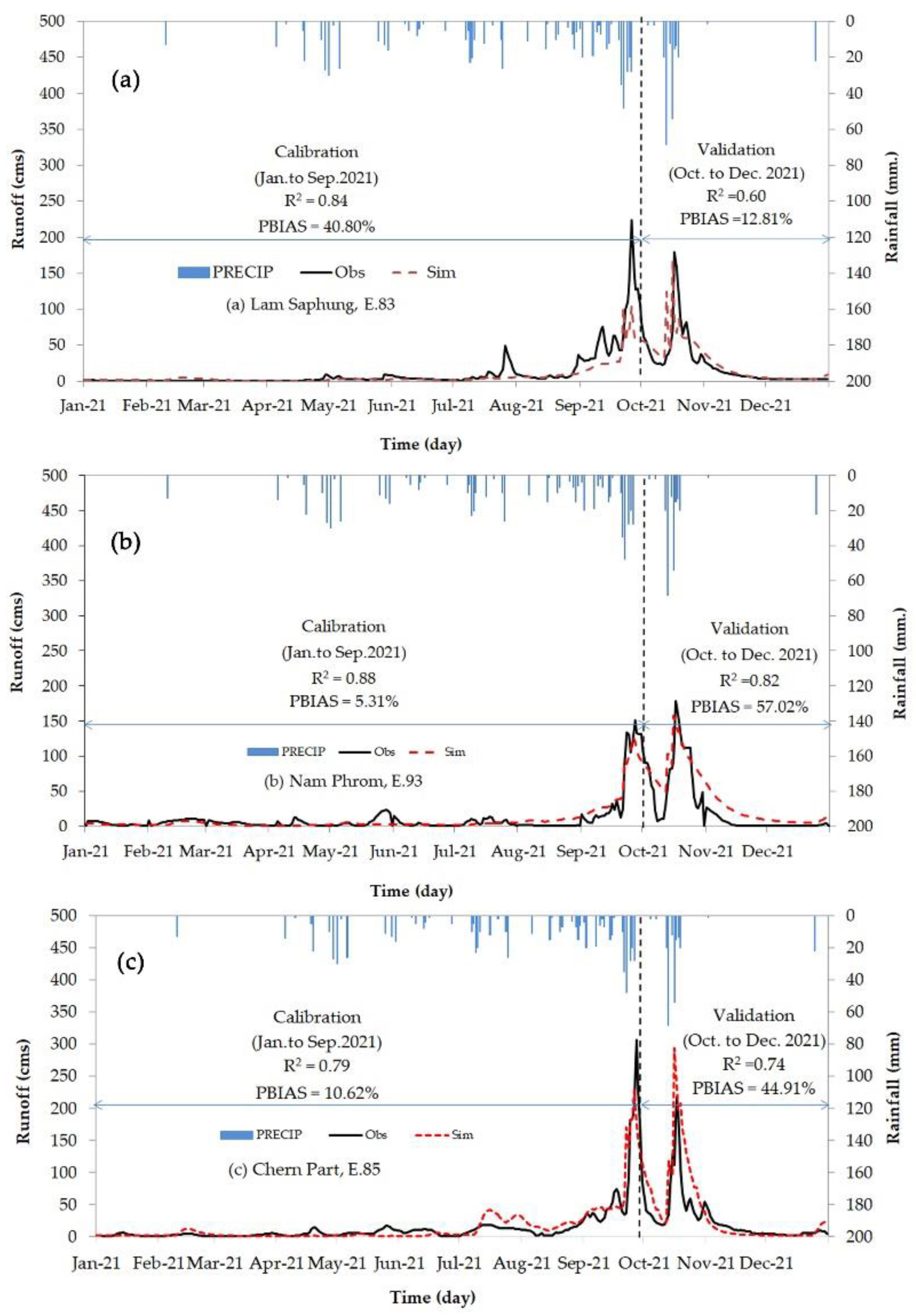
Figure 13.
The daily runoff of the Lam Saphung Basin, Phrom Basin, and Chern Basin Part 1 when using land use maps for only 2021 with the rainfall data in various years.
Figure 13.
The daily runoff of the Lam Saphung Basin, Phrom Basin, and Chern Basin Part 1 when using land use maps for only 2021 with the rainfall data in various years.
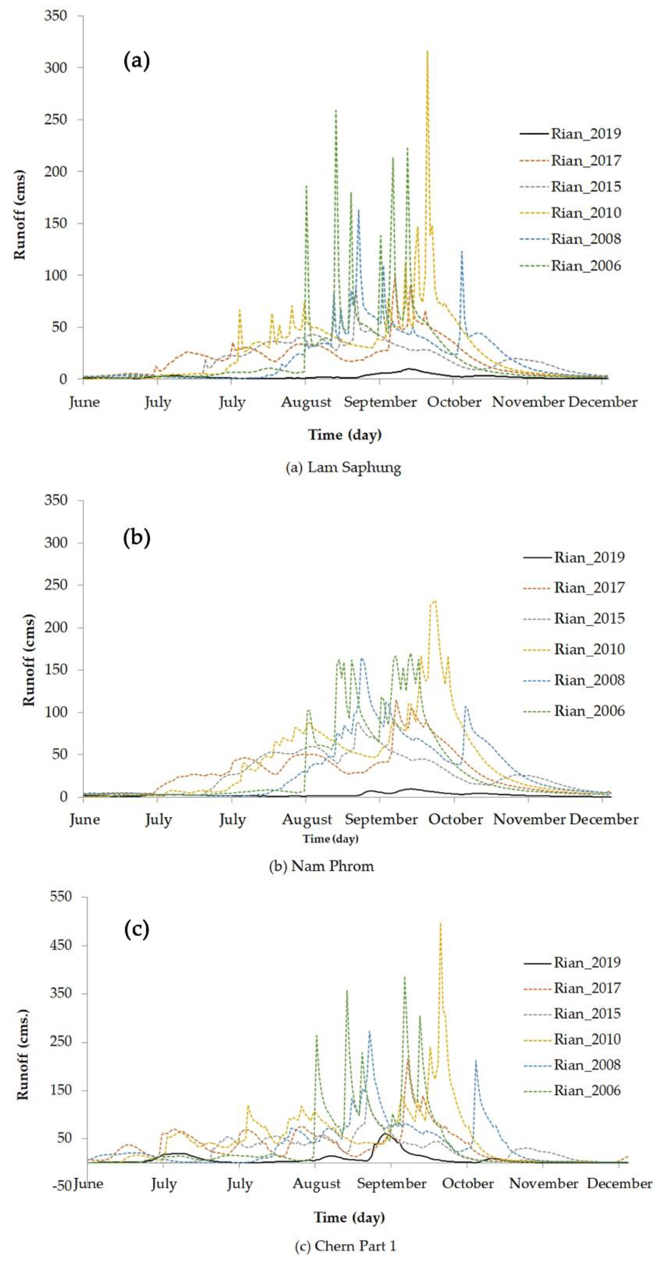
Figure 14.
The percentage change rate for residential land use types as compared with the base line year of 2006.
Figure 14.
The percentage change rate for residential land use types as compared with the base line year of 2006.
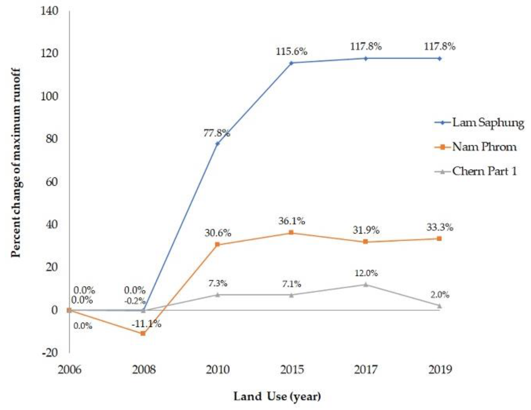
Figure 15.
The percentage of change rate for maximum runoff as compared with the base line year of 2006 when using the least rainfall year (2019) with the various land use maps of 2006, 2008, 2010, 2015, 2017 and 2019.
Figure 15.
The percentage of change rate for maximum runoff as compared with the base line year of 2006 when using the least rainfall year (2019) with the various land use maps of 2006, 2008, 2010, 2015, 2017 and 2019.
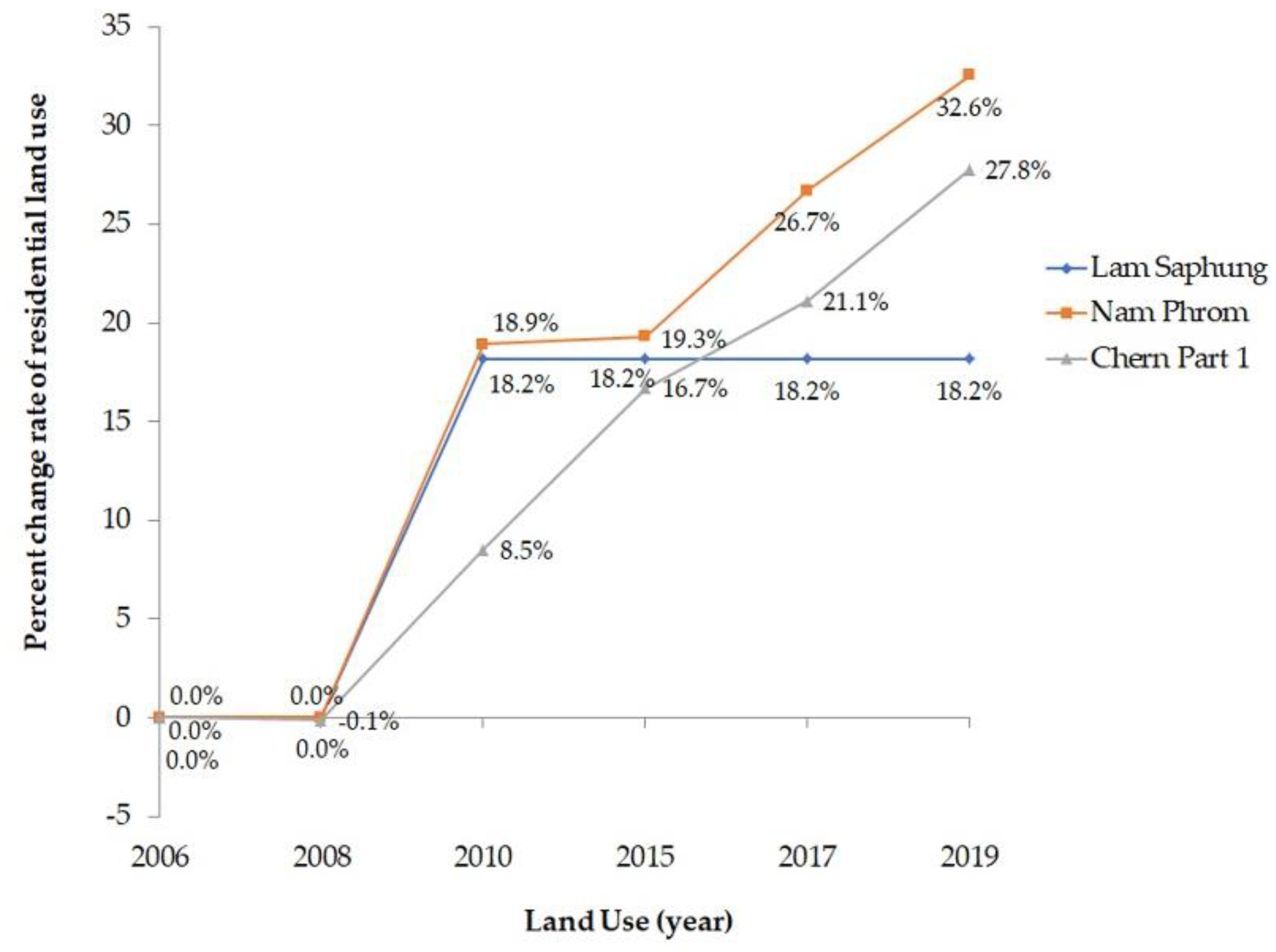
Table 1.
Data Used in Simulating Water Scenarios.
| Data Sources During the year 2006-2021 | |
|---|---|
| DEM | Department of Land Development |
| Soil Type Map | Department of Land Development |
| Land Use Map | Department of Land Development |
| Meteorological Data | Meteorological Department |
| Runoff | Department of Irrigation |
Table 2.
Summarizes the area of each type of land use in each watershed.
| No. | Land use | Area (km2) | |||||
| 2006 | 2008 | 2010 | 2015 | 2017 | 2019 | ||
| 1. | Lam Saphung | ||||||
| Agricultural land | 25.8 | 25.7 | 29.8 | 30.3 | 30.7 | 33.1 | |
| Forest land | 639.5 | 639.4 | 632.2 | 628.0 | 628.1 | 625.6 | |
| Urban and built-up land | 1.1 | 1.1 | 1.2 | 1.3 | 1.3 | 1.3 | |
| Water body | 1.1 | 1.2 | 3.8 | 3.8 | 3.8 | 3.7 | |
| Other | 75.9 | 75.9 | 76.4 | 79.9 | 79.4 | 79.7 | |
| Total | 743.4 | 743.3 | 743.3 | 743.3 | 743.3 | 743.4 | |
| 2. | Nam Phrom | ||||||
| Agricultural land | 769.8 | 769.5 | 770.2 | 770.5 | 795.8 | 809.4 | |
| Forest land | 1,287.1 | 1,286.5 | 1,267.5 | 1,265.8 | 1,257.8 | 1,243.1 | |
| Urban and built-up land | 51.3 | 51.3 | 61.0 | 61.2 | 65.0 | 68.0 | |
| Water body | 36.7 | 36.7 | 56.6 | 56.6 | 56.1 | 58.5 | |
| Other | 119.1 | 119.6 | 108.3 | 109.6 | 89.1 | 84.8 | |
| Total | 2,263.9 | 2,263.7 | 2,263.7 | 2,263.7 | 2,263.7 | 2,263.7 | |
| 3. | Chern Part 1 | ||||||
| Agricultural land | 755.4 | 756.9 | 760.3 | 763.9 | 783.7 | 786.2 | |
| Forest land | 902.6 | 894.4 | 877.1 | 860.4 | 854.3 | 847.3 | |
| Urban and built-up land | 90.4 | 90.3 | 98.1 | 105.5 | 109.5 | 115.5 | |
| Water body | 19.2 | 18.7 | 29.1 | 32.3 | 33.2 | 36.1 | |
| Other | 131.2 | 138.2 | 134.0 | 136.4 | 117.9 | 113.4 | |
| Total | 1,898.7 | 1,898.5 | 1,898.5 | 1,898.5 | 1,898.6 | 1,898.5 | |
Table 3.
displays the optimal results obtained from the calculations of the model using 8 parameters over 500 simulation rounds.
Table 3.
displays the optimal results obtained from the calculations of the model using 8 parameters over 500 simulation rounds.
| No. | Parameter | Description | File Type | Ranking Range | Optimal Value | ||
| E.83 | E.93 | E.85 | |||||
| 1. | Cn2 | Initial curve number (II) value | .Mgt | 0.1 – 0.1 | 0.045766 | 0.0458 | 0.0093825 |
| 2. | Sol_Awc | Available water capacity [(mm water) (mmsoil)-1] |
.Soil | 0 – 0.7 | 0.7476 | 0.7476 | 0.6941 |
| 3. | Esco | (Soil evaporation compensation factor | .hru | 0 – 0.2 | -5.67 | -5.67 | 0.19005 |
| 4. | Gwqmn | Thershold water depth in the shallow aquifer for flow [mm] | .gw | 0 – 500 | 500 | 500 | 500 |
| 5. | Gw_Revap | Groundwater ‘revap’ coefficient | .gw | 0.6 – 0.95 | 0.191 | 0.191 | 0.7614 |
| 6. | CH_N2 | Manning’s N value for the main channel | . rte | 0 – 0.3 | 0.6 | 0.6 | 0.0999 |
| 7. | Gw_Delay | Groundwater delay [days] |
.gw | --15 – 15 | 0.6941 | 0.6941 | 0.57 |
| 8. | Alpha_Bf | Baseflow alpha factor [days] | .gw | 0 – 1 | 0.0555 | 0.0555 | 0.7476 |
Table 4.
presents the performance indices of the SWAT model.
| Watershed | Interval | Year (B.E.) | Average runoff (m3) |
Index | ||||
|---|---|---|---|---|---|---|---|---|
| Observe | SWAT | R2 | PBIAS | RMSE | NSE | |||
| Lam Saphung | Calibration | January – September 2021 | 2977.83 | 1762.78 | 0.84 | 40.80% | 15.61 | 0.654 |
| Validation | October – December 2021 | 2118.65 | 2389.61 | 0.60 | 12. 81% | 21.57 | 0.608 | |
| Total | January – December 2021 | 5096.48 | 4152.39 | 0.65 | 17.31% | 17.31 | 0.637 | |
| Nam Phrom | Calibration | January – September 2021 | 2478.59 | 2347.074 | 0.88 | 5.31% | 7.95 | 0.874 |
| Validation | October – December 2021 | 4856.31 | 3733.487 | 0.82 | 57.02% | 23.20 | 0.737 | |
| Total | January – December 2021 | 2377.72 | 6080.561 | 0.81 | 25.25% | 13.53 | 0.795 | |
| Chern Part 1 | Calibration | January – September 2021 | 3646.84 | 4034.21 | 0.79 | 10.62% | 15.37 | 0.783 |
| Validation | October – December 2021 | 2316.92 | 3357.38 | 0.74 | 44.63% | 33.91 | 0.205 | |
| Total | January – December 2021 | 5963.76 | 7391.60 | 0.72 | 23.83% | 21.60 | 0.604 | |
Table 5.
Maximum runoff volume of selected study areas when using rainfall data in 2021 with the various land use maps.
Table 5.
Maximum runoff volume of selected study areas when using rainfall data in 2021 with the various land use maps.
| Watershed | Rainfall (year) | Land use map (year) | Period of occurrence |
Maximum Runoff (m3) |
| Lam Saphung | 2021 | 2019 | 10 October | 169.3 |
| 2017 | 169.1 | |||
| 2015 | 169.1 | |||
| 2010 | 168.7 | |||
| 2008 | 168.0 | |||
| 2006 | 168.0 | |||
| Nam Phrom | 2021 | 2019 | 10 October | 157.0 |
| 2017 | 156.6 | |||
| 2015 | 156.1 | |||
| 2010 | 156.0 | |||
| 2008 | 154.8 | |||
| 2006 | 154.8 | |||
| Chern Part 1 | 2021 | 2019 | 10 October | 299.8 |
| 2017 | 299.0 | |||
| 2015 | 298.3 | |||
| 2010 | 296.3 | |||
| 2008 | 294.3 | |||
| 2006 | 293.3 |
Table 6.
The maximum runoff volume of the Lam Saphung Basin, Phrom Basin, and Chern River Basin Part 1 when using land use maps for only 2021 with the rainfall data from various years.
Table 6.
The maximum runoff volume of the Lam Saphung Basin, Phrom Basin, and Chern River Basin Part 1 when using land use maps for only 2021 with the rainfall data from various years.
| Watershed | Land use map (year) | Rainfall data (year) | Maximum runoff (m³) | Period of Occurrence |
| Lam Saphung | 2021 | 2019 | 9.8 | October 10, 2019 |
| 2017 | 81.6 | October 4, 2017 | ||
| 2015 | 88.3 | September 19, 2015 | ||
| 2010 | 316.1 | October 18, 2010 | ||
| 2008 | 162.8 | September 20, 2008 | ||
| 2006 | 258.6 | October 21, 2006 | ||
| Nam Phrom | 2021 | 2019 | 9.25 | October 11, 2019 |
| 2017 | 115.2 | October 5, 2017 | ||
| 2015 | 88.3 | September 19, 2015 | ||
| 2010 | 222.6 | October 20, 2010 | ||
| 2008 | 164.7 | September 21, 2008 | ||
| 2006 | 162.0 | October 4, 2006 | ||
| Chern Part 1 | 2021 | 2019 | 63.4 | September 26, 2019 |
| 2017 | 215.7 | September 5, 2017 | ||
| 2015 | 140.6 | September 19, 2015 | ||
| 2010 | 498.2 | October 18, 2010 | ||
| 2008 | 273.3 | September 19, 2008 | ||
| 2006 | 387.5 | October 4, 2006 |
Table 8.
The maximum runoff volumes when using the least rainfall year (2019) with the various land use maps of 2006, 2008, 2010, 2015, 2017 and 2019.
Table 8.
The maximum runoff volumes when using the least rainfall year (2019) with the various land use maps of 2006, 2008, 2010, 2015, 2017 and 2019.
| Watershed | The maximum runoff volumes (m3/s) | |||||
| 2006 | 2008 | 2010 | 2015 | 2017 | 2019 | |
| Lam Saphung | 4.5 | 4.5 | 8.0 | 9.7 | 9.8 | 9.8 |
| Nam Phrom | 7.2 | 6.4 | 9.4 | 9.8 | 9.5 | 9.6 |
| Chern Part 1 | 59.3 | 59.2 | 63.6 | 63.5 | 66.4 | 60.5 |
Disclaimer/Publisher’s Note: The statements, opinions and data contained in all publications are solely those of the individual author(s) and contributor(s) and not of MDPI and/or the editor(s). MDPI and/or the editor(s) disclaim responsibility for any injury to people or property resulting from any ideas, methods, instructions or products referred to in the content. |
© 2024 by the authors. Licensee MDPI, Basel, Switzerland. This article is an open access article distributed under the terms and conditions of the Creative Commons Attribution (CC BY) license (http://creativecommons.org/licenses/by/4.0/).
Copyright: This open access article is published under a Creative Commons CC BY 4.0 license, which permit the free download, distribution, and reuse, provided that the author and preprint are cited in any reuse.


