Submitted:
04 January 2024
Posted:
05 January 2024
You are already at the latest version
Abstract
In Mexico, the evaluations of environmental flows are regulated by the Mexican Norm NMX-AA-159-SCFI-2012 and they warrant the establishment of water reserves for the environment. Yet, the pressure for water use limits the establishment of said reserves. This research aimed to evaluate the changes through time of the variables that serve as a basis for the implementation strategy by the Mexican government. A geographical information system was built with updated variables, the desired conservation status was analyzed, and the potential reserves were estimated based on the reference values for all basins nationwide. The results were examined according to their historical, current, and potential contribution to the conservation of natural protected areas and their connectivity. The outcomes point towards an administrative implementation strategy with positive outcomes despite the growing pressure for water use, with a change rate higher than the one for the creation of new protected areas. Currently, basins with low pressure and high conservation value have the potential to contribute to 86–88% of the goal set by the present administration without affecting water availability. Finally, reserving water in the priority basins would guarantee the legal protection of the flow regime in 48–50% of the hydrographic network in a desired conservation status, 45–49% of wetlands of international importance, and other natural protected areas in 85–89% of the global ecoregions represented in Mexico.
Keywords:
Connectivity
; Basin
; Ecological importance
; Environmental objectives
; Pressure for water use
; Water allocation.
1. Introduction
The circulation of water on the planet has been fundamental to the development of civilizations throughout history. The use that societies have given to the water from rivers and wetlands has been the foundation of their well-being. The role played by the environment as a guarantor of ecosystem services is crucial, as these depend on the integrity of ecological processes such as connectivity for water and food provision, and the regulation of both climate and the ecosystems that mitigate the adverse effects of extreme events such as droughts and floods [1,2,3].
Despite the value of water in nature, aquatic ecosystems are by far the most threatened globally due to overexploitation, modification of flow regimes for productive uses, and pollution resulting in the loss or degradation of habitat and the establishment of exotic and invasive species, along with other emerging threats such as climate change [3,4,5]. Although these ecosystems cover only 1% of the world’s surface, they harbor 10% of biodiversity [6], yet approximately 83% of the species abundance within them has been lost in the last 50 years [7]. Even though rivers connect terrestrial and marine environments, only 37% of large rivers maintain a state of intact connectivity, and only 17% have some form of protection scheme [8,9].
Environmental flows are defined as the quantity, timing, and quality of freshwater flows and levels necessary to sustain aquatic ecosystems which, in turn, support human cultures, economies, sustainable livelihoods, and well-being [2]. They are widely recognized in the specialized literature as a central element for both environmentally sustainable and comprehensive water management and for achieving related Sustainable Development Goals [2,3,10]. In Mexico, their assessment is regulated by the Mexican Norm NMX-AA-159-SCFI-2012, which establishes the procedure for determining the environmental flow in hydrological basins and has been a cornerstone for water allocation to mediate between the needs for productive uses and the conservation of ecological processes and ecosystem services [11,12].
An environmental water reserve (EWR) is an administrative instrument for management grounded on Article 41 of the National Water Law through which a volume is allocated to remain in the environment based on the application of the Mexican Norm NMX-AA-159-SCFI-2012 [11,12]. In 2012, the country set the goal of reserving water for the environment in 189 selected basins due to their availability, low usage pressure, conservation interest, and other favorable attributes as a preventive strategy from water management to halt the increasing pressure for water use to which basins are subjected and ensure their sustainable development [3,11,12,13,14,15,16].
More than ten years after the initiative to allocate water to the environment started, studies have been developed to systematize experiences regarding the performance of methods for the evaluation and the implementation of environmental flows, and the commitment to continue reserving water in the country has been reaffirmed [12,16,17,18,19,20]. However, to date, no research has been conducted on changes in the key variables for establishing water reserves and implementing the Mexican Norm NMX-AA-159-SCFI-2012, even though it establishes the desired conservation state of basins based on pressure for water use and ecological importance at that time (Appendix A of the cited norm) [21,22]. Likewise, its effects on public policy goals and on instruments to guarantee long-term environmentally and socially sustainable use have not been analyzed, nor has the potential contribution to the conservation of protected areas, their connectivity, and on the biodiversity dependent on the integrity of flow regimes. Filling this knowledge gap is essential to contribute to the water security public policy agenda.
The main research aim of this manuscript is to evaluate changes over time (2012–2022) in the variables that affect the feasibility of establishing water reserves for ecological protection, and to conduct the first assessment of environmental flows in the country’s hydrological basins for water planning purposes, to identify areas with sufficient availability and those that are deficient. Additionally, to examine the results based on their potential contribution to the conservation of the connectivity of protected areas, dependent ecosystems, and what this means for the global ecoregions of aquatic ecosystems present in Mexico. Understanding the temporal changes in the variables that underlie the strategic framework for evaluating environmental flows will contribute to the update, monitoring, and long-term implementation of public policy goals in a broader context.
2. Materials and Methods
The methodological procedure consists of three main stages. The first stage focuses on the collection of updated information, useful for water and protected area management, and its geographic processing. The second stage encompasses both the fundamentals and the detailed evaluation for prioritizing basins with feasibility as potential water reserves and the environmental objective class (desired conservation state) for environmental flow assessments based on the principles of the Mexican Norm NMX-AA-159-SCFI-2012. Lastly, third stage incorporates the analysis of changes from 2012 to 2022, progress to date in water allocation to the environment in the country, and the potential scope of results based on three considerations for the conservation and management of dependent ecosystems:
- Natural areas such as protected areas, internationally important wetlands (Ramsar sites), and gaps in epicontinental aquatic conservation officially recognized by the Mexican state [13].
2.1. Definitions, Data Sources, and Geographic Processing
A potential water reserve consists of a hydrological basin, as a basic management unit, identified as feasible for the development of detailed on-site studies of environmental flow to support its establishment, given favorable characteristics such as water availability, low pressure for its use, and conservation interest [11,12,13,16]. To ensure the temporal analysis under the same criteria, the collection of updated information was based on the following variables: availability and water stress status (water exploitation index), conservation value (natural protected areas, internationally important wetlands, and gaps in epicontinental aquatic conservation), presence of bans, hydraulic infrastructure, agricultural activities, and population density (Table 1) [11,13].
The source information used to build the database comes from official sources, including the National Water Commission (CONAGUA as in Spanish), the National Commission of Natural Protected Areas (CONANP), the National Commission for the Knowledge and Use of Biodiversity (CONABIO), the National Population Commission (CONAPO), and the National Institute of Statistics and Geography (INEGI). It was obtained in vector format (shapefile) through institutional transparency portals, personal communication [25], and ad-hoc calculations. All the information was aggregated by hydrological basin, as the basic functional unit for water management and administration on the national geographic continuum [19].

Table 1.
Key variables by hydrological basin and information sources for the identification of potential water reserves. Source: Authors’ own elaboration based on [13].
Table 1.
Key variables by hydrological basin and information sources for the identification of potential water reserves. Source: Authors’ own elaboration based on [13].
| Variable | Definition | Source |
|---|---|---|
| Water availability. In the case of surface waters, it is the difference in volume that results between the mean annual runoff from the hydrological basin downstream and the volume committed by water usage. In the case of groundwater, it is the difference between the mean annual recharge volume, the natural committed discharge 1, and the extraction of groundwater. | It is the determining indicator for the creation of reserves with a preventive focus. If there is no water available in the hydrological basin, water cannot be allocated to the environment. | Mean annual balances 2 of surface and ground water availability [19,25,26]. |
| Water Stress. The percentage relationship between the mean annual surface runoff, including that generated within the own basin and that coming from upstream sources (or recharge in the case of aquifers), and the volumes extracted for productive water uses, losses due to evaporation, and reservoir level variations. | It is an indicator of the degree of water resource exploitation. With higher pressure, there is increased competition for water and reduced potential for establishing reserves. | Calculated from the Mexican Norm with updated information from personal communication [19,25,26]. |
| Water bans. A management tool in response to water overexploitation or in situations of extreme drought (severe scarcity) or in an emergency caused by water pollution, exploitation, use, or utilization. | The existence of water bans is crucial for the establishment of reserves as they provide legal precedent and are the basis for the reserves with an availability preventive cause. | SEMARNAT and CONAGUA [19,25,26]. |
| Water reserves. A management tool to allocate volumes for domestic or urban-public use, energy generation for public service, or to ensure minimum flows for ecological protection, including the conservation or restoration of vital ecosystems. | Legal foundation for their establishment and an indicator of progress in public policy for the allocation of water to the environment. | SEMARNAT and CONAGUA [16,19,25,26]. |
| Natural Protected Areas (NPAs) at federal, state, and municipal levels, as well as areas voluntarily designated for conservation, internationally important wetlands (Ramsar sites), and the priorities, gaps or omissions in the conservation of epicontinental aquatic biodiversity. | The circulation of water in the environment is fundamental for sustaining the ecological functioning of natural areas recognized by the state. It is the conservation value indicator for the establishment of water reserves for ecological protection. | CONABIO and CONANP [27,28,29]. |
| Irrigation districts and units. | Irrigation farming has a direct effect on land use change and alterations to the natural runoff regime, which is key to establishing the environmental flows that support the reserves. | CONAGUA [30]. |
| Location and volumes of large dams (≥15 m curtain height compared to the maximum level of ordinary flow or ≥3 Hm3 capacity). | Pressure of water use indicator; it might limit the reserves. | CONAGUA [31]. |
| Total population, density, and growth rate. | Development indicators, the higher the population, density, and growth rate, the larger the demand for water use and lower feasibility for establishing reserves. | CONAPO and INEGI [32,33,34]. |
1 Fraction of an aquifer's natural discharge that is committed as surface water for various uses or that must be conserved to prevent negative environmental impacts on ecosystems or the migration of poor-quality water into an aquifer. 2 Includes the corresponding values (Hm3/year) for each of the elements of the balance according to the Mexican Norm NOM-011-CONAGUA-2015. For surface water: runoff within the basin (Wb), upstream runoff (UpS), consumptive use (UCa), concessioned or in a concession’s emission process (UCb), water reserves for the environment (UCc), total uses (UCa+UCb+UCc), returns (R), imports (IM), exports (EX), evaporation (EV), variation in reservoirs (FV or AV), surface water extraction (AB), downstream commitment (RXY), and mean annual availability per basin (D). Groundwater: total annual recharge (R), committed natural discharge (CND), groundwater extraction (VEAS), allocated (VCAS), water extraction on free springing provisional suspension zones and in areas registered on the National Permanent Registry (VEALA), extraction pending from title (VAPYR), reserves, rules and water programs (VAPRH), and mean annual availability per aquifer (DMA).
In order to guide the development of the global information matrix for the historical analysis, the reference used was the dataset created and managed by the World Wide Fund for Nature (WWF) for the National Water Reserves Program, available on the CONABIO web portal [27,28]. The geographic processing was carried out using ArcGIS 10.8 and QGIS 3.28.3, and it involved the integration of variables grounded on their spatial location, using topological intersection methods, or recalculating based on the presence or absence of the incorporated coverages on the resulting layers.
2.2. Criteria for Prioritizing Basins for the Preventive Allocation of Water through Reserves and Environmental Objectives
The same procedures of the original studies were given that they hold public interest criteria, established in the policy instruments. For the prioritization of basins as potential water reserves, an assessment was conducted based on the relative weight assigned to each variable, whether exclusive, positive, or negative according to its interpretation, criteria, and weighting factors Table 2. Variables, interpretation, criteria, and weighting factors for the feasibility assessment of potential water reserves. NPA: natural protected area; Bs: basin surface; Ids: irrigation district surface; As: aquifer surface; Dcv: dam capacity volume; Bmar: basin mean annual runoff (generated within the basin and the one coming from upstream). Source: elaborated by the authors from [11,13] (Table 2) [11,13]. To assess and integrate the level of exploitation of aquifers and their influence on the basin, the treatment involved, first, calculating water stress due to groundwater extraction based on international recommendations (< 40% = low and ≥ 40% = high). Subsequently, the representativeness of aquifers and their levels of exploitation were considered per basin, as the central unit of management in this study, to classify them based on the risk of surface impact due to groundwater extraction. The integration algorithm is presented in Equation (1), and the cut-off criteria for the final feasibility classification are as follows: very high = 4.25–5, high = 3.25–4, medium = 2.25–3, not a candidate or low ≤ 2, and exclusion of basins without water availability or pressure ≥ 10%.
where, P is the priority to conduct the environmental flow studies that sustain the feasibility of the declaration of water reserves, Fav is the availability factor (> 0 Hm3 and water stress < 10%), Fci is the conservation interest, Fbans presence of bans, Fpd population density, Fid irrigation districts, Finf hydraulic infrastructure (dams), and Fga groundwater extraction affectation. The temporal analysis was performed by comparing the results of previous analyses from 2011, 2013 and 2016.
P = Fav + Fci + Fbans + Fid + Finf + Fga + Fpd
Regarding the classification of environmental objectives for environmental flow assessments, it was carried out based on the conceptual principles of the Mexican Norm NMX-AA-159-SCFI-2012. In summary, this standard recognizes, on one hand, that the seasonal and interannual variability of the natural hydrological regime, in terms of attributes such as magnitude, frequency, duration, timing, and rate of change, as well as its components of ordinary and extraordinary flows, are essential for the development of ecological processes, functions, and ecosystem services. On the other hand, it acknowledges that as water resources are used and the regime is modified, the biological-ecological condition of the ecosystem degrades [12,16,17,18]. Apart from the various environmental flow assessment methods used for water planning and management or research purposes (e.g., hydrological, ecohydrological, habitat simulation, or holistic approaches) [15,35,36], the environmental flows are assessed based on the assignment of environmental or management objectives. These objectives establish a balance between water uses, resource conservation, and dependent ecosystems [10,11]. The classification of environmental objectives for setting environmental flow recommendations in regulatory instruments in any country serves as the core of public policy in water administration and management. This is because it determines the level of integrity of the environmental flow regime, which in turn underpins the legal framework for protection.
In the Mexican case, an environmental objective represents ecological integrity, defined as the degradation level of an ecosystem caused by human activities that triggered the loss or transformation of its structural and functional characteristics [21]. These objectives are established as a function of the pressure for water usage in the basin and its ecological importance, in a combination of classes (Figure 1), where “A” implies a very good desired conservation state, “B” a good one, “C” a moderate state, and “D” a deficient state (Appendix A of the NMX-AA-159-SCFI-2012) [11,12,16,17,37]. Thus, the model incorporates fundamental ecohydrological principles that emphasize the system’s dependence on the natural hydrological regime, as well as the ecological consequences of its alteration [10,38,39].
The classification of pressure for water use was based on the percentage relationship between availability and the volumes extracted for productive uses, losses due to evaporation, and reservoir level variations (low ≤ 10%, medium ≥ 11%, high ≥ 40%, and very high ≥ 80% = high). It is important to note that for the existing water reserves for ecological protection, the volumes designated for this purpose were reintegrated into availability to conduct the assessment under the same conditions as the initial evaluation. Regarding the ecological importance, consideration was given to the presence of natural protected areas of any level (federal, state, municipal, or private), internationally important wetlands (Ramsar sites), and gaps or omissions in epicontinental aquatic conservation. Concerning the latter, at least 34 gaps and omissions were considered. The value was obtained from the central range theory of distributions to identify the sites with the highest concentration according to the frequency in the last quartile (very high if all three conditions are met = natural protected areas, Ramsar site, and ≥ 34 conservation gaps; high if at least two conditions are met, medium if at least one condition is met, and low if there are no protected natural areas, Ramsar site, and ≥ 34 conservation gaps [11,22]). Lastly, for the temporal analysis, the results were compared with the environmental objectives published in the Mexican Norm NMX-AA-159-SCFI-2012 and the updated information from availability balances, natural protected areas, and internationally important wetlands as of 2016 [12,40].
2.3. Temporal Analysis: the Path to the Current State and Assessment of Achievements
2.3.1. Conservation and Management of Protected Areas
Despite the conceptual recognition of the importance of freshwater circulation in the landscape for the conservation of natural protected areas and internationally important wetlands (Ramsar sites), currently, only one site includes in its management program the role of the environmental flow in its conservation: the Marismas Nacionales Biosphere Reserve in Nayarit [17,41]. Hence, the temporal analysis of results included the extension of these natural areas located in the basins of potential water reserves, the area benefiting from conservation gaps and omissions, and progress to date in the legal protection of the flow regime.
2.3.2. Water Reserves for Water Planning Based on Reference Values
The conservation and management of water resources are not only fundamental for the protection of ecological processes and functions but also ensure the provision of ecosystem services on which human rights depend, such as the right to a healthy environment and access to water in a sustainable and timely manner. Therefore, the protection of environmental flows is a goal of the National Water Program 2020-2024 and the Special Climate Change Program 2021-2024 [20,23]. In this regard, the difference between the number of basins with existing reserves and potential reserves was examined, along with the opportunity it presents to advance in compliance with the mentioned public policy instruments.
In line with the above, the first comprehensive assessment of water reserve volumes for ecological protection was conducted in all the basins of the country that currently do not have such a scheme in order to identify where water is available in sufficient quantity to ensure environmental flow, which basins are deficient, and the levels of deficiency. This assessment is based on systematic analyses of outcomes that have demonstrated consistency between hydrological, ecohydrological, and holistic methods generated in nearly 300 case studies in Mexico reported in scientific literature [12,16,17,18]. The water reserve volumes for the country’s basins were determined based on their assigned environmental objectives, according to their ecological significance and current pressure for water use, except in 266 basins where water reserves were already enacted, in such cases reserved volumes were used [16,42,43]. Reference values from the ecohydrological method were based on the frequency of occurrence and seasonal and interannual variability of hydrological regime components, as recognized in Appendix D of the NMX-AA-159-SCFI-2012 (Application 2).
Among the available reference value options, this study used water reserve volumes based on the central distribution range of percentages of the mean annual runoff for each environmental objective class of each analysis unit. For class “A,” it was 59% of the runoff generated within the basin plus that from upstream (Wb + UpS in availability balances), “B” was 44%, “C” was 35%, and “D” was 26% [16]. These reference values are expressed as percentages of the mean annual runoff and are recognized in the international literature solely for water planning purposes, even when the source of information comes from monthly or annual-scale precipitation-runoff models, as is the case in Mexico. And so, for the purpose of this research, the approximation is appropriate (look-up tables, [15,16,17,18,36]). Water reserve calculations were performed using the global database in Microsoft Excel.
2.3.3. Potential Contribution to the Conservation of the Connectivity of Aquatic Ecosystems
The physical-spatial dimensions of connectivity, including longitudinal connectivity between the main river channels and their tributaries along the basin from headwaters to the mouth, lateral connectivity between rivers and adjacent wetlands in floodplains, and vertical connectivity through the interaction of surface, subsurface, and groundwater, are naturally regulated by the temporal dimension [44,45,46,47,48,49]. Protecting the flow regime is key for conserving and managing the ecological integrity of aquatic ecosystems [38,50,51]. The implementation of environmental flows is a top priority step in global action and emergency plans to reverse or at least halt the degradation of these ecosystems [2,3]. Therefore, legal protection for free-flowing rivers, that is to say free of infrastructure that alters the flow and flood regime, is a crucial move [8,9,16,49,52,53].
To analyze Mexico’s potential contribution to the conservation of connectivity, the length of its free-flowing rivers from headwaters to the mouth and the segments in good conservation status (conservation status index, CSI > 95% [8]) in basins with water reserves (baseline), the potential water reserves from this evaluation, and those with a environmental objective class “A” were examined. To obtain the representation of the results, information on free-flowing rivers worldwide corresponding to the Mexican territory was extracted from the free-flowing rivers map server (Hydrolab). From the national hydrographic network, connected segments of free-flowing rivers and those in good conservation status with impacts greater than 5% according to the indicator created by the original source were filtered (fields INC and CSI_FF2 in the original attribute table [54]). Finally, the representation of the potential water reserves from this evaluation and those with a environmental objective class “A” in the context of global ecoregions of aquatic ecosystems was also examined [24].
3. Results and Discussion
3.1. Feasibility Status of Water Reseves
Unlike the previous analyses, the administrative division of hydrological basins now stands at 757, 29 more management units than in 2011 (Table 3). Despite this increase, the overall rate of change is noteworthy, and, particularly, the loss of basins identified as potential water reserves (189 in 2011 vs. 146 in 2022, a decrease of 23%). Except for medium feasibility, which has remained relatively stable over time (~116), the rest of the prioritization categories have been affected.
In 2011, 54 basins with high feasibility were identified, while in 2022, there are only 26 remaining, roughly half. In 2011, 19 basins had very high feasibility, but in 2022, only 4 meet the desired conditions. This can be explained by two reasons: the first is related to the number of basins that meet all the assessment conditions (457 vs. 447). The second reason, which is related to the first, is due to the increase in excluded basins due to the lack of mean annual surface water availability or an increase in water stress (271 vs. 310). This finding demonstrates that water use for productive uses continues to be environmentally and socially unsustainable despite the existing public policies and regulations during the analyzed period.
In terms of their geographical distribution, there is a significant number of potential water reserves in the Baja California (Northwest) and Yucatán (East) peninsulas. The first, despite its limited natural water availability, indicates that population growth remains low. The second, due to its abundant surface and groundwater availability, with high conservation interest in both cases (Figure 2). The number of basins identified on the Pacific Ocean side stands out, subject to seasonal hydrological variability that distinguishes it significantly from those draining in to the Gulf of Mexico side. Finally, it’s worth noting that in the northern part of the country, there is still water available for the environment. In addition to the aforementioned potential reserves in the Baja California peninsula, there are also management units which meet the established criteria, located in the Northwest-ern states of the Hydrological Regions: 25 San Fernando-Soto La Marina and 34 Cuencas Centrales del Norte.
3.2. Effect of the Change on Protected Areas and Recognized Conservation Gaps
Currently, Mexico has a system of 187 federal protected areas covering a total of 909,673 km2, encompassing terrestrial ecosystems (173,818 km2 of continental surface, islands, and epicontinental water bodies), exclusive marine areas (440,433 km2), and mixed environments (295,422 km2 in coastal or terrestrial-marine areas) [55]. This evaluation of potential water reserves extends over 76,723 km2, with direct or indirect benefits to protected areas in case of enacting the environmental flows that sustain them (Table 4). This represents a difference of 9,408 km2 compared to the initial report (11% rate of change during the analysis period) [13].
As for internationally important wetlands, there are currently 145 Ramsar sites covering an area of 87,274 km2 [56]. Since ecological processes in wetlands are dependent on flood regimes, 37,379 km2 are identified with direct benefits. This indicator shows an additional 8,367 km2 compared to the previously reported figures (29% rate of change) [13].
Table 4.
Extension in square kilometers of potential water reserves, natural protected areas, internationally important wetlands, and gaps and omissions in the conservation of epicontinental aquatic ecosystems.
Table 4.
Extension in square kilometers of potential water reserves, natural protected areas, internationally important wetlands, and gaps and omissions in the conservation of epicontinental aquatic ecosystems.
| Feasibility | Very high | High | Medium | Total |
|---|---|---|---|---|
| Potential water reserve | 26,241 | 144,450 | 241,289 | 411,980 |
| Natural Protected Areas | 15,431 | 23,718 | 37,575 | 76,723 |
| Protected Flora and Fauna Area | 1366 | 8603 | 8527 | 18,496 |
| Natural Resources Protected Area | 0 | 16 | 4310 | 4326 |
| National Monument | 0 | 27 | 42 | 69 |
| National Park | 0 | 194 | 443 | 637 |
| Biosphere Reserve | 14,064 | 14,875 | 24,241 | 53,179 |
| Sanctuary | 0 | 4 | 11 | 15 |
| Ramsar Sites | 7387 | 18,525 | 11,467 | 37,379 |
| Gaps and omissions (class) | 8953 | 38,400 | 81,055 | 128,408 |
| Extreme | 3899 | 9367 | 23,287 | 36,553 |
| High | 3112 | 12,203 | 16,643 | 31,957 |
| Medium | 1942 | 16,830 | 41,125 | 59,897 |
To fully appreciate the potential benefit of protecting environmental flows through the identified potential reserves, it is necessary to consider it as part of the surface of the territory through which water flows, particularly in areas that currently lack legal protection instruments, such as protected areas and recognized gaps and omissions in conservation. In this regard, the global set of 146 potential water reserves implies a drainage area of 411,980 km2. Although this represents –8% rate of change compared to what was reported previously [13], 90,438 km2 correspond to federal protected natural areas and internationally important wetlands. The remaining 321,542 km2 contains gaps and omissions in conservation (128,408 km2), and 193,134 km2 are identified as new areas of exclusively hydrological protection not covered by any current instrument. This represents 146% increase compared to the potential water reserves of 2011. This positive difference is due to the increase of 29 hydrological basins from one period to another, with the Southeastern Peninsula region being a notable addition.
3.3. Environmental Objectives for Environmental Flow Assessments
In general, the classification of environmental objectives for hydrological basins follows the same trend as the identification of potential water reserves. Regarding water pressure of use, the temporal analysis reveals increases with rates of change ranging from 5% to 21% between the low and very high classifications, respectively (Table 5). On the contrary, and despite the addition of 25 management units for the analysis period, the ecological importance in the basins reflects the opposite relationship, albeit to a lesser extent (1–12%). Given the changes in both pressure for water use and ecological importance, the classification of environmental objectives has also been impacted; in general, the most significant changes are found in the central categories (B–C). For the environmental objective class “D”, representing a desired conservation state labeled as deficient, the number of basins has increased from 156 to 220 (41% rate of change), while for class “C,” which represents a desired medium ecological state, the change is from 304 to 105 basins (–190%). On the other hand, the change for class “B” is from 82 to 292 basins (256% with a desired good conservation state), and for class “A,” it is from 190 to 140 basins (26%).
Geographically, basins with environmental objectives of class “A” and “B” are mostly distributed in the two peninsulas, coastal basins along both the Pacific Ocean and Gulf of Mexico, and with a small representation in the northwestern region, as well as in the Central Northern basins (Figure 3). In contrast, basins with environmental objectives of class “C” and “D” are concentrated in the northernmost region and in the central-southern Mexico.
3.4. Gaps in Water Reserves for Management Planning
Out of the 757 basins in the country, 266 have existing water reserves. Among the remaining 491 basins, the use of reference values for reserve volumes for water planning reveals that 323 basins are suitable for establishing new reserves to meet national goals [20,23]. However, 168 of these basins are in deficit, meaning they lack sufficient availability (Table 6; Figure 4). As previously reported, these water availability deficient basins would require detailed environmental flow studies for flow regime reconstruction, adjustments to environmental objectives, and implementation strategies to involve the recovery of consumptive water volumes [11,16].
Regarding the performance of water reserve volumes for water planning based on reference values, the proportion of basins with a surplus of water availability is concentrated in those with environmental objectives class “A” and “B” (98% for each class), with the lowest number of outliers (11–12%) (Figure 5). Conversely, in deficit basins, both environmental objectives class “C” and “D” experience the highest proportion of both conflict (75% and 45%, respectively) and outliers (25% and 29%).
In general, this result is consistent with the expected as previously reported, both in the method’s proof of concept as well as in case studies that include desktop assessments (ecohydrological methods) and others supported by holistic approaches [12,16,17,18,57,58] (De la Lanza Espino et al. 2012 and 2015, Salinas-Rodríguez et al. 2018, 2020, 2021, and 2022). However, the reserve volumes should be taken with caution due to the associated uncertainty in the desired conservation states of “medium” and “deficient.” Another limitation to be considered is that reference values are applied without differentiation between the type of dominant stream in the basins (e.g., perennial, intermittent, or ephemeral) since it is not possible to determine it from the availability balances [16,17,18].
3.5. Strategic Contribution of the Reserves to Public Policy and Potential Gains for the Conservation of Aquatic Ecosystem Connectivity
Although the reduction in feasible potential water reserves from 2011 to 2022 may have had an impact on the goal of establishing 189 reserves for ecological protection, to date, 266 have been established and remain in place. From the current set of basins with reserves, only 27 are identified as potential, so there are still 119 possible new establishments in accordance with national goals [42,43]. As previously reported, the total set of established water reserves exceeded the goal due to management opportunities arising from hydrological connectivity between a select group of units and their contributing upstream basins [16,59]. To ensure the required volumes in the target reserves, it was necessary to ensure connectivity through availability balances, and consequently, reserve the water from the generating or contributing basins.
Unlike previous reports [16], the adjustment of the contribution of current reserves to the protection of flow regimes on the drainage network is around 443,000 km2, providing legal certainty to ensure connectivity, at least in good conservation condition, along ~41,600 km (31% of the national hydrographic network), ~12,200 km2 in 39 Ramsar wetlands of international importance, ~59,850 km2 in 54 federal protected natural areas, as well as ~442,700 km2 with representation of 70% of the global aquatic ecosystem ecoregions present in Mexico (Table 7). In terms of biodiversity, this benefits at least ~240 protected species, ~180 of which are freshwater-dependent (~80 protected) [37]. Moreover, according to a recent report from the International Union for Conservation of Nature (IUCN), this water protection scheme has the potential to improve the conservation status of 450 fish species in Mexico [60]. According to the present evaluation of potential water reserves and basins with environmental objective class “A”, the gain for the conservation of aquatic ecosystem connectivity could increase to around 63,760–66,900 km of rivers with at least a good state of conservation in their connectivity (48–50% of the national hydrographic network), 48,650–49,600 km2 in 62–66 wetlands (43–46%), 128,700–136,500 km2 in 84–92 protected natural areas (45–49%), and 780,500–852,200 km2 with representation of 85–89% of the global aquatic ecosystem ecoregions present in the country.
The experience gained in the allocation of water for the environment over the last decade is revealing for its scope and is acknowledged in scientific literature [3,9,15,52,53,59,60]. The results have the potential to be leveraged through public policy for water resources management, conservation, and addressing climate change. Currently, the federal government has the goal of increasing the number of basins with ecological reserves to 448, which means an addition of 182 to the existing ones, along with the development of complementing regulations to ensure the flow regime timing implementation [20,23,61]. Focusing the strategy on the remaining set of 119 basins with potential water reserves and the hydrologically connected management units would provide certainty regarding the current water availability, its low usage pressure, and conservation interest, contributing at least 86% towards achieving the goals of the 2020-2024 National Water Program and the 2021-2024 Special Climate Change Program.
4. Conclusions and Recommendations
The results of this research show that over the last decade, the form and geospatial distribution of pressure for water use in Mexico’s basins is advancing at a higher rate compared to the creation of new protected areas. Although both aspects are crucial for achieving a balance between water use and conservation, water pressure is the most determining factor reported in international literature and, therefore, limits the establishment of water reserves for ecological protection. It is an indicator of the level of over-exploitation of resources whose use alters the regime and pollutes water, leading to the loss or degradation of habitat (e.g., connectivity) and of the biodiversity living in aquatic ecosystems.
The strategy adopted in Mexico to proactively implement environmental flows through water allocation for ecological protection, in basins with low usage pressure and significant conservation interest, has been successful according to performance indicators established in public policy instruments and recognized by specialized literature. However, this was due to the need —and the water management opportunity— to ensure the connectivity of environmental flows in a limited number of basins through all their contributing units located upstream. While reserves has been guaranteed in only 27 of the initially identified potential basins, there are still 119 management units that meet the conditions of low usage pressure and significant conservation interest. This number could contribute to around 86% of the goal set in National Programs by 2024, with the certainty that they have water availability, low water pressure, and conservation interest for the protection of environmental flows, without considering the need to also ensure those of the contributing basins upstream, which has proven to have positive implications from water management.
Finally, the evaluation of environmental flows based on reference values for water planning shows that up to 88% of the country’s basins have sufficient and potential availability to manage their administrative implementation through the water reserves legal figure, regardless of their environmental objective class. However, given the associated uncertainty in basins with different desired conservation states, as well as the hydrological nature of the main watercourses (ephemeral, intermittent, or perennial), it is recommended to design differentiated strategies for their implementation, i.e., focusing on conservation, management, restoration, or the reconstruction of environmental flow regimes, as well as conducting more detailed studies.
In the cases of basins with certainty of low pressure for water use and high conservation importance with at least a good state of conservation in their connectivity, Mexico’s contribution to achieving Sustainable Development Goals related to water could secure the legal protection of the regime in 48-50% of the hydrographic network, 43-46% of international importance wetlands, 45-49% of protected natural areas, and 85-89% of global ecoregions in the country, unprecedented country-scale numbers in response to the call to action for the implementation of environmental flows as a top priority to halt the loss of biodiversity in aquatic ecosystems.
Supplementary Materials
The database for the current national assessment is available online at Preprints.org.
Author Contributions
Conceptualization, methodology, formal analysis, investigation, project administration, supervision, visualization, writing—original draft preparation, S.A.S.-R.; validation, resources, data curation, funding acquisition, writing—review and editing, S.A.S.-R. and A.H.P.M. All authors have read and agreed to the published version of the manuscript.
Funding
This research was funded by El Colegio de la Frontera Sur and the World Wide Fund for Nature (WWF Mexico), grant number ECOSUR/CONVENIO/E/030/VIH/2022. Furthermore, it supports the National Research and Advocacy Project “Ecohydrology for the sustainability and governance of water and basins for the common good”, funded by the Mexican National Council of Humanities, Sciences and Technologies and operated by the Water Reserves Monitoring Network, grant number 318956. The APC was funded WWF Mexico.
Institutional Review Board Statement
Not applicable.
Data Availability Statement
The data presented in this study are available in www.mdpi.com/xxx/.
Acknowledgments
We are thankful to Sofía Álvarez Castrejón for her support on the manuscript translation and style proof-reading.
Conflicts of Interest
The authors declare no conflict of interest.
References
- Forslund A, D.; Renöfält, B.M.; Barchiesi, S.; Cross, K.; Davidson, S.; Farrell, T.; Korsgaard, L.; Krchnak, K.; McClain, M.; Meijer, K.; et al. Securing water for ecosystems and human well-being: The importance of environmental flows; SIWI: 2009.
- Arthington, A.H.; Bhaduri, A.; Bunn, S.E.; Jackson, S.E.; Tharme, R.E.; Tickner, D.; Young, B.; Acreman, M.; Baker, N.; Capon, S.; et al. The Brisbane Declaration and Global Action Agenda on Environmental Flows (2018). Frontiers in Environmental Science 2018, 6. [Google Scholar] [CrossRef]
- Tickner, D.; Opperman, J.; Abell, R.; Acreman, M.; Arthington, A.H.; Bunn, S.E.; Cooke, S.J.; Dalton, J.; Darwall, W.; Edwards, G.; et al. Bending the Curve of Global Freshwater Biodiversity Loss: An Emergency Recovery Plan. BioScience 2020, 330–342. [Google Scholar] [CrossRef]
- Dudgeon, D.; Arthington, A.H.; Gessner, M.O.; Kawabata, Z.-I.; Knowler, D.J.; Lévêque, C.; Naiman, R.J.; Prieur-Richard, A.-H.; Soto, D.; Stiassny, M.L.J.; et al. Freshwater biodiversity: importance, threats, status and conservation challenges. Biological Reviews 2006, 81, 163–182. [Google Scholar] [CrossRef] [PubMed]
- Reid, A.J.; Carlson, A.K.; Creed, I.F.; Eliason, E.J.; Gell, P.A.; Johnson, P.T.J.; Kidd, K.A.; Maccormack, T.J.; Olden, J.D.; Ormerod, S.J.; et al. Emerging threats and persistent conservation challenges for freshwater biodiversity. Biological Reviews 2019, 94, 849–873. [Google Scholar] [CrossRef] [PubMed]
- Strayer, D.L.; Dudgeon, D. Freshwater biodiversity conservation: recent progress and future challenges. Journal of the North American Benthological Society 2010, 29, 344–358. [Google Scholar] [CrossRef]
- World Wide Fund for Nature (WWF). Living Planet Report 2022 – Building a naturepositive society; WWF: Gland, Switzerland, 2022; Available online: https://wwfint.awsassets.panda.org/downloads/embargo_13_10_2022_lpr_2022_full_report_single_page_1.pdf (accessed on 19 of December 2023).
- Grill, G.; Lehner, B.; Thieme, M.; Geenen, B.; Tickner, D.; Antonelli, F.; Babu, S.; Borrelli, P.; Cheng, L.; Crochetiere, H.; et al. Mapping the world’s free-flowing rivers. Nature 2019, 569, 215–221. [Google Scholar] [CrossRef]
- Perry, D.; Harrison, I.; Fernandes, S.; Burnham, S.; Nichols, A. Global Analysis of Durable Policies for Free-Flowing River Protections. Sustainability 2021, 13, 2347. [Google Scholar] [CrossRef]
- Acreman, M.; Arthington, A.H.; Colloff, M.J.; Couch, C.; Crossman, N.D.; Dyer, F.; Overton, I.; Pollino, C.A.; Stewardson, M.J.; Young, W. Environmental flows for natural, hybrid, and novel riverine ecosystems in a changing world. Frontiers in Ecology and the Environment 2014, 12, 466–473. [Google Scholar] [CrossRef]
- Barrios Ordóñez, J.E.; Salinas Rodríguez, S.A.; Martínez, A.; López Pérez, M.; Villón Bracamonte, R.A.; Rosales Ángeles, F. National Water Reserves Program in Mexico. Experiences with Environmental Flows and the Allocation of Water for the Environment; BID-TN-864; Inter-American Development Bank, Water and Sanitation Sector: 2015. [CrossRef]
- Salinas-Rodríguez, S.A.; Barrios-Ordóñez, J.E.; Sánchez-Navarro, R.; Wickel, A.J. Environmental flows and water reserves: Principles, strategies, and contributions to water and conservation policies in Mexico. River Research and Applications 2018, 34, 1057–1084. [Google Scholar] [CrossRef]
- Comisión Nacional del Agua (CONAGUA). Identificación de reservas potenciales de agua para el medio ambiente en México. 2011. Available online: https://www.conagua.gob.mx/CONAGUA07/Publicaciones/Publicaciones/SGT-3-11Media.pdf (accessed on 19 of December 2023).
- Horne, A.C.; O’Donnell, E.L.; Tharme, R.E. Chapter 17 - Mechanisms to Allocate Environmental Water. In Water for the Environment, Horne, A.C., Webb, J.A., Stewardson, M.J., Richter, B., Acreman, M., Eds.; Academic Press: 2017; pp. 361–398.
- Opperman, J.J.; Kendy, E.; Tharme, R.E.; Warner, A.T.; Barrios, E.; Richter, B.D. A Three-Level Framework for Assessing and Implementing Environmental Flows. Frontiers in Environmental Science 2018, 6. [Google Scholar] [CrossRef]
- Salinas-Rodríguez, S.A.; Barba-Macías, E.; Infante-Mata, D.; Nava-López, M.Z.; Neri-Flores, I.; Domínguez-Varela, R.; González-Mora, I.D. What Do Environmental Flows Mean for Long-term Freshwater Ecosystems’ Protection? Assessment of the Mexican Water Reserves for the Environment Program. Sustainability 2021, 13, 1240. [Google Scholar] [CrossRef]
- Salinas-Rodríguez, S.A.; Sánchez-Navarro, R.; Barrios-Ordóñez, J.E. Frequency of occurrence of flow regime components: a hydrology-based approach for environmental flow assessments and water allocation for the environment. Hydrological Sciences Journal 2020, 66, 193–213. [Google Scholar] [CrossRef]
- Salinas-Rodríguez, S.A.; van de Giesen, N.C.; McClain, M.E. Inter-Annual and Seasonal Variability of Flows: Delivering Climate-Smart Environmental Flow Reference Values. Water 2022, 14, 1489. [Google Scholar] [CrossRef]
- Secretaría de Medio Ambiente y Recursos Naturales (SEMARNAT). Acuerdo por el que se actualiza la disponibilidad media anual de las aguas nacionales superficiales de las 757 cuencas hidrológicas que comprenden las 37 Regiones Hidrológicas en que se encuentra dividido los Estados Unidos Mexicanos. 2020. Available online: https://www.dof.gob.mx/nota_detalle.php?codigo=5600849&fecha=21/09/2020#gsc.tab=0 (accessed on 19 of December 2023).
- Secretaría de Medio Ambiente y Recursos Naturales (SEMARNAT). Programa Especial de Cambio Climático 2021-2024. 2021. Available online: https://www.gob.mx/cms/uploads/attachment/file/681172/PECC-2021-2024.pdf (accessed on 19 of December 2023).
- Secretaría de Economía. Norma Mexicana NMX-AA-159-SCFI-2012 Que establece el procedimiento para la determinación del caudal ecológico en cuencas hidrológicas. 2012. Available online: https://www.gob.mx/cms/uploads/attachment/file/166834/NMX-AA-159-SCFI-2012.pdf (accessed on 19 of December 2023).
- Schroeder Aguirre, A.A.; Salinas Rodríguez, S.A. Guía para la aplicación de la Norma Mexicana para la determinación del régimen de caudal ecológico en cuencas hidrológicas: Aproximaciones hidrológicas, hidrobiológicas y holísticas. Comisión Nacional del Agua. 2011.
- Secretaría de Medio Ambiente y Recursos Naturales (SEMARNAT). Programa Nacional Hídrico 2020-2024. 2020. Available online: https://www.dof.gob.mx/nota_detalle.php?codigo=5609188&fecha=30/12/2020#gsc.tab=0 (accessed on 19 of December 2023).
- Abell, R.; Thieme, M.L.; Revenga, C.; Bryer, M.; Kottelat, M.; Bogutskaya, N.; Coad, B.; Mandrak, N.; Balderas, S.C.; Bussing, W.; et al. Freshwater Ecoregions of the World: A New Map of Biogeographic Units for Freshwater Biodiversity Conservation. BioScience 2008, 58, 403–414. [Google Scholar] [CrossRef]
- Sánchez Montufar, O. ; Technical Advisory Manager, Transparency Liaison of the General Technical Subdirectorate, National Water Commission, Mexico City; Salinas Rodríguez S.A. Associate Researcher, Department of Sustainability Sciences, El Colegio de la Frontera Sur, Villahermosa, Tabasco. Personal Communication (Folio No. 1610100126621 and Official Letter No. B00.7.03-022). 2021.
- Secretaría de Medio Ambiente y Recursos Naturales (SEMARNAT). Acuerdo por el que se actualiza la disponibilidad media anual de agua subterránea de los 653 acuíferos de los Estados Unidos Mexicanos, mismos que forman parte de las regiones hidrológico-administrativas que se indican. 2020. Available online: https://dof.gob.mx/nota_detalle.php?codigo=5600593&fecha=17/09/2020#gsc.tab=0 (accessed on 19 of December 2023).
- Comisión Nacional para el Conocimiento y Uso de la Biodiversidad y Comisión Nacional de Áreas Naturales Protegidas (CONABIO-CONANP). Sitios prioritarios para la conservación de los ecosistemas acuáticos epicontinentales. 2010. Available online: http://www.conabio.gob.mx/informacion/gis/?vns=gis_root/region/biotic/spec1mgw (accessed on 19 of December 2023).
- Comisión Nacional para el Conocimiento y Uso de la Biodiversidad (CONABIO). Áreas naturales protegidas, estatales, municipales, ejidales, comunitarias y privadas de México. 2020. Available online: http://www.conabio.gob.mx/informacion/gis/maps/geo/anpest20gw.zip (accessed on 19 of December 2023).
- Comisión Nacional de Áreas Naturales Protegidas (CONANP). Información espacial de las áreas naturales protegidas. 2023. Available online: http://sig.conanp.gob.mx/website/pagsig/info_shape.htm (accessed on 19 of December 2023).
- Comisión Nacional del Agua (CONAGUA). Distritos y unidades de riego. 2022.
- Comisión Nacional del Agua (CONAGUA). Presas principales. 2022.
- Comisión Nacional de Población (CONAPO). Proyección de la población de los municipios de México, 2015-2030. 2019.
- Insituto Nacional de Estadística Geografía e Informática (INEGI). Censo de población y vivienda 2010. 2010.
- Insituto Nacional de Estadística Geografía e Informática (INEGI). Censo de población y vivienda 2020. 2020.
- Tharme, R.E. A global perspective on environmental flow assessment: emerging trends in the development and application of environmental flow methodologies for rivers. River research and applications 2003, 19, 397–441. [Google Scholar] [CrossRef]
- Poff, N.L.; Tharme, R.E.; Arthington, A.H. Evolution of Environmental Flow Assesments: science, principles, and methodologies. In Water for the Environment: from Policy and Science to Implementation and Management, Horne, A., Webb, J.A., Stewardson, M.J., Richter, B., Acreman, M., Eds.; Academic Press: San Diego, CA, 2017; pp. 203–236. [Google Scholar]
- Salinas Rodríguez, S.A. Contribución de las reservas de agua para protección ecológica en materia de conservación de la biodiversidad: Línea base para la selección de objetos estratégicos de conservación; Red de Monitoreo de Reservas de Agua: 2022; p. 20.
- Bunn, S.E.; Arthington, A.H. Basic Principles and Ecological Consequences of Altered Flow Regimes for Aquatic Biodiversity. Environmental Management 2002, 30, 492–507. [Google Scholar] [CrossRef]
- Davies, S.P.; Jackson, S.K. The biological condition gradient: A descriptive model for interpreting change in aquatic ecosystems. Ecological Applications 2006, 16, 1251–1266. [Google Scholar] [CrossRef]
- Martínez-Pacheco, A.I.; Salinas-Rodríguez, S.A. Servidor cartográfico del Programa Nacional de Reservas de Agua (Versión 10.2). 2018. [Google Scholar]
- Secretaría de Medio Ambiente y Recursos Naturales y Comisión Nacional de Áreas Naturales Protegidas (SEMARNAT-CONANP). Programa de manejo: reserva de la biósfera Marismas Nacionales.Mexico City, Mexico, 2013; p. 199. 2013.
- Secretaría de Medio Ambiente y Recursos Naturales (SEMARNAT). Decreto por el que se deja insubsistente el diverso por el que se suprimen las vedas existentes en las cuencas hidrológicas Río Actopan y Río Antigua, de la Subregión Hidrológica Papaloapan A, de la Región Hidrológica número 28 Papaloapan, y se establecen reservas superficiales para usos doméstico, público urbano y ambiental o para la conservación ecológica en las mismas cuencas hidrológicas, publicado el 6 de junio de 2018. 2022. Available online: https://www.dof.gob.mx/nota_detalle.php?codigo=5652171&fecha=17/05/2022#gsc.tab=0 (accessed on 19 of December 2023).
- Secretaría de Medio Ambiente y Recursos Naturales (SEMARNAT). Decreto por el que se deja sin efectos el diverso por el que se suprimen las vedas existentes en las cuencas hidrológicas Río Papagayo 1, Río Petaquillas, Río Omitlán, Río Papagayo 2, Río Papagayo 3, Río Papagayo 4, Río Nexpa 1, Río Nexpa 2, Río La Arena 1 y Río La Arena 2, pertenecientes a la Región Hidrológica número 20 Costa Chica de Guerrero y se establecen zonas de reserva de aguas nacionales superficiales para los usos doméstico, público urbano y ambiental o para conservación ecológica en las cuencas hidrológicas que se señalan, las cuales forman parte de la Región Hidrológica antes referida, publicado el 3 de mayo de 2018. 2022. Available online: https://www.dof.gob.mx/nota_detalle.php?codigo=5650819&fecha=03/05/2022#gsc.tab=0 (accessed on 19 of December 2023).
- Vannote, R.L.; Minshall, G.W.; Cummins, K.W.; Sedell, J.R.; Cushing, C.E. The River Continuum Concept. Canadian Journal of Fisheries and Aquatic Sciences 1980, 37, 130–137. [Google Scholar] [CrossRef]
- Ward, J. The four-dimensional nature of lotic ecosystems. Journal of the North American Benthological Society 1989, 8, 2–8. [Google Scholar] [CrossRef]
- Junk, W.; Bailey, P.B.; Sparks, R.E. The Flood pulse concept in river-floodplain systems. In Proceedings of the International Large River Symposium, Dodge, D.P., Ed. Fish and Aquatic Science: Canada, 1989; Volume 106, pp. 110–127. [Google Scholar]
- Junk, W.J. The flood pulse concept of large rivers: learning from the tropics. SIL Proceedings, 1922-2010 2001, 27, 3950–3953. [Google Scholar] [CrossRef]
- Grantham, T.E.; Matthews, J.H.; Bledsoe, B.P. Shifting currents: Managing freshwater systems for ecological resilience in a changing climate. Water Security 2019, 8, 100049. [Google Scholar] [CrossRef]
- Poff, N.L. A river that flows free connects up in 4D. Nature 2019, 569, 201–202. [Google Scholar] [CrossRef] [PubMed]
- Poff, N.L.; Allan, J.D.; Bain, M.B.; Karr, J.R.; Prestegaard, K.L.; Richter, B.D.; Sparks, R.E.; Stromberg, J.C. The natural flow regime: a new paradigm for riverine conservation and restoration. BioScience 1997, 47, 769–784. [Google Scholar] [CrossRef]
- Richter, B.; Baumgartner, J.; Wigington, R.; Braun, D. How much water does a river need? Freshwater Biology 1997, 37, 231–249. [Google Scholar] [CrossRef]
- Arthington, A.H.; Tickner, D.; McClain, M.E.; Acreman, M.C.; Anderson, E.P.; Babu, S.; Dickens, C.W.S.; Horne, A.C.; Kaushal, N.; Monk, W.A.; et al. Accelerating environmental flows implementation to bend the curve of global freshwater biodiversity loss. Environmental Reviews 2023. [Google Scholar] [CrossRef]
- Piczak, M.; Perry, D.; Cooke, S.J.; Harrison, I.; Benitez, S.; Koning, A.A.; Peng, L.; Limbu, P.; Smokorowski, K.; Salinas-Rodríguez, S.A.; et al. Protecting and restoring habitats to benefit freshwater biodiversity. Environmental Reviews 2023. [Google Scholar] [CrossRef]
- Grill, G.; Lehner, B. Mapping the world’s free-flowing rivers: data set and technical documentation. Nature 2019. [Google Scholar] [CrossRef]
- Comisión Nacional de Áreas Naturales Protegidas (CONANP). Numeralia sobre la Áreas Naturales Protegidas de México. 2023.
- Secretariat, R.C. Wetlands of international importance in Mexico. 2023. Available online: https://www.ramsar.org/es/country-profile/mexico (accessed on 19 of December 2023).
- De La Lanza Espino, G.; Carbajal Pérez, J.L.; Salinas Rodríguez, S.A.; Barrios Ordoñez, J.E. Medición del caudal ecológico del río Acaponeta, Nayarit, comparando distintos intervalos de tiempo. Investigaciones Geográficas. [CrossRef]
- De la Lanza Espino, G.; Carbajal Pérez, J.L.; Salinas Rodríguez, S.A. Cálculo de flujo ambiental como sustento para la reserva de agua del río Piaxtla, Sinaloa, México. Investigaciones Geográficas 2014, 87, 25–38. [Google Scholar] [CrossRef]
- Opperman, J.J.; Kendy, E.; Barrios, E. Securing Environmental Flows Through System Reoperation and Management: Lessons From Case Studies of Implementation. Frontiers in Environmental Science 2019, 7. [Google Scholar] [CrossRef]
- Lyons, T.J.; Máiz, T.L.; Tognelli, M.; Daniels, A.; Meredith, C.; Bullock, R.; Harrison, I. The status and distribution of freshwater fishes in Mexico; IUCN: Cambridge, UK and Albuquerque, New Mexico, USA, 2020. [Google Scholar]
- Secretaría de Medio Ambiente y Recursos Naturales (SEMARNAT). Lineamientos para incluir volúmenes no comprometidos de aguas nacionales superficiales en los 10 decretos de reservas de agua, publicados el 6 de junio de 2018 a través de la Programación Hídrica. 2019. Available online: https://www.dof.gob.mx/nota_detalle.php?codigo=5564306&fecha=27/06/2019#gsc.tab=0 (accessed on 19 of December 2023).
Figure 1.
Matrix for the classification of environmental objectives. Source: Mexican Norm NMX-AA-159-SCFI-2012.
Figure 1.
Matrix for the classification of environmental objectives. Source: Mexican Norm NMX-AA-159-SCFI-2012.
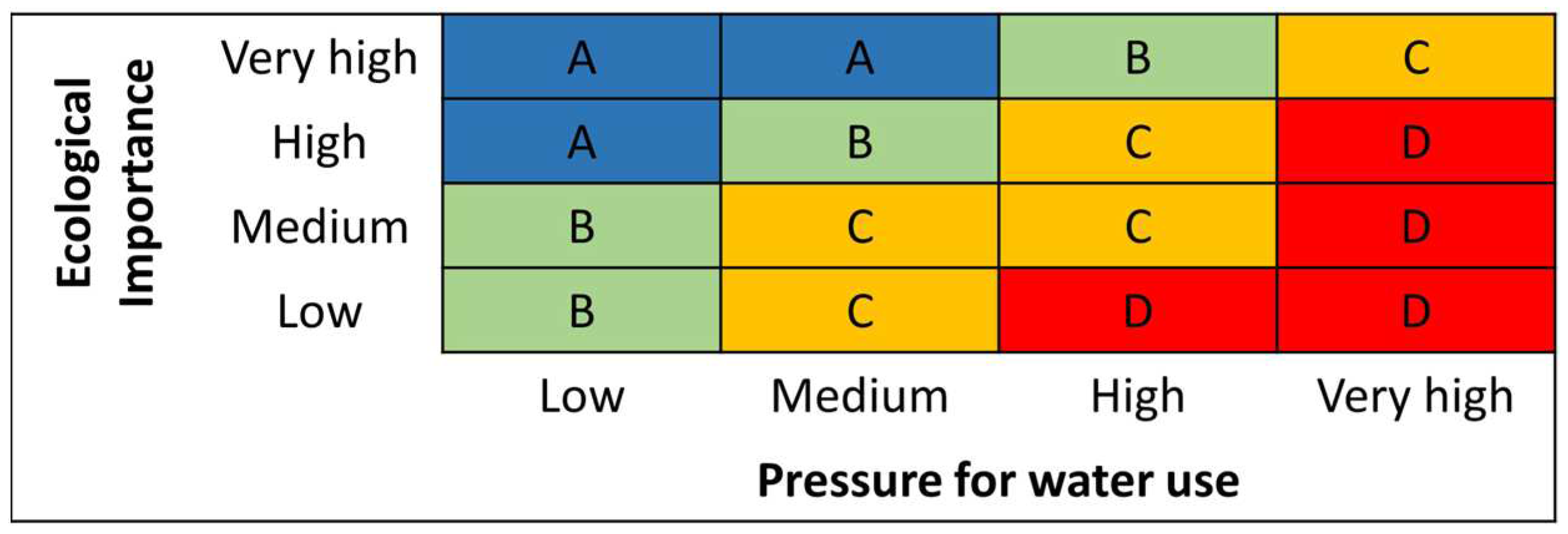
Figure 2.
Geographic distribution of the basin identified as potential water reserves.
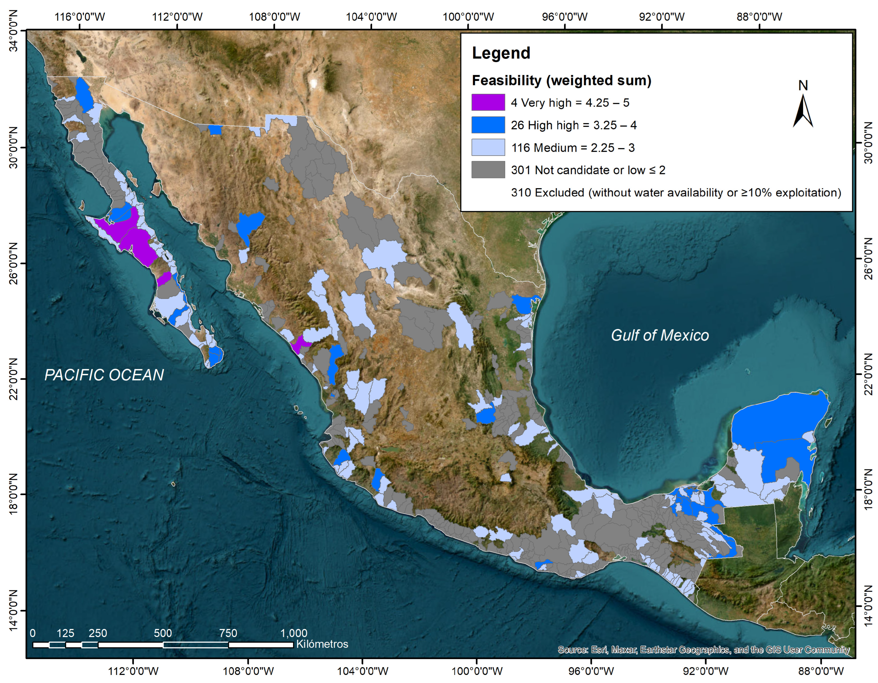
Figure 3.
Geographic distribution of the environmental objectives’ classes by hydrological basin.
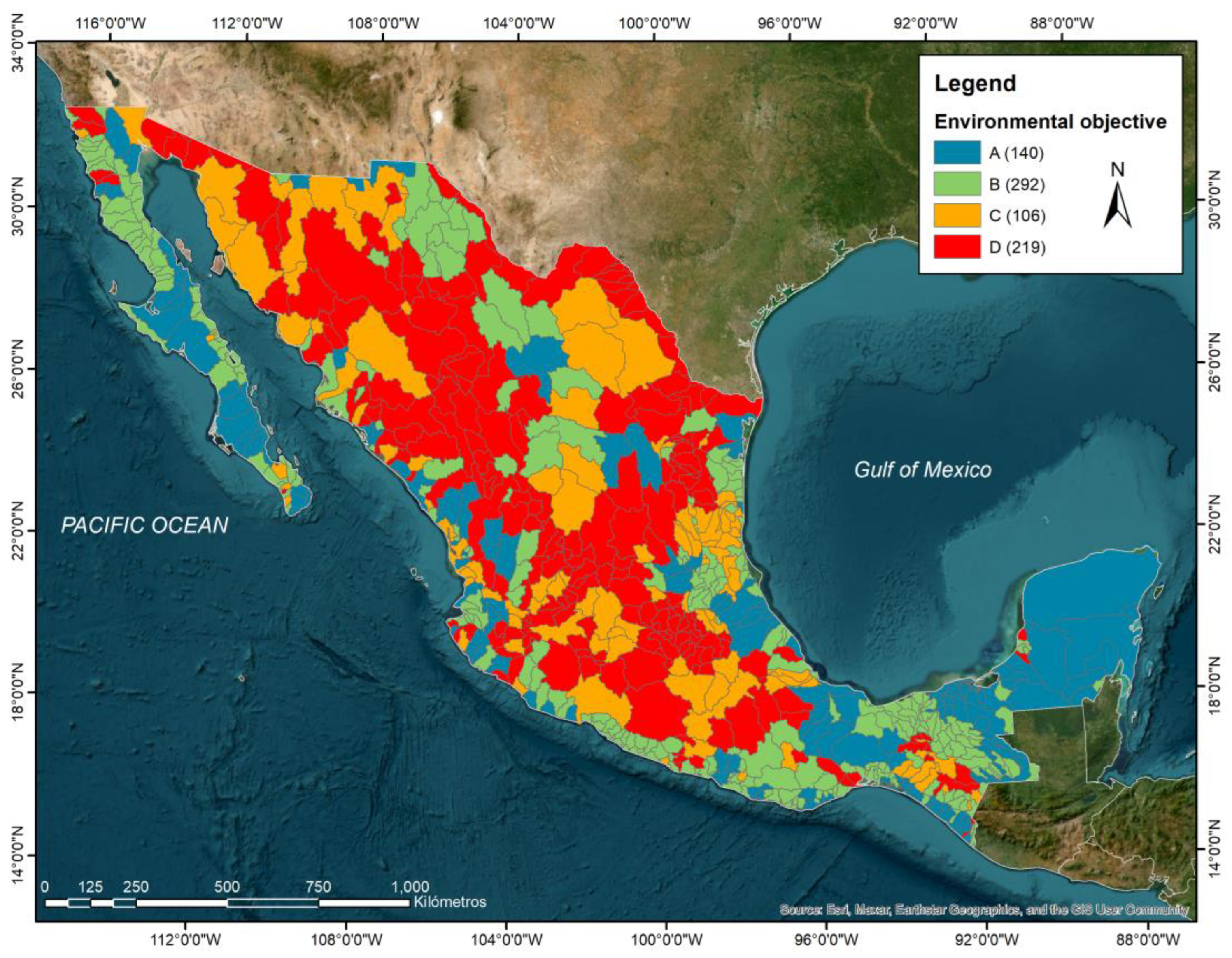
Figure 4.
Geographical location of the country’s basins with current water reserves, and the surplus and deficit of water availability for the establishment of new reserves (volume of current water availability minus reserves).
Figure 4.
Geographical location of the country’s basins with current water reserves, and the surplus and deficit of water availability for the establishment of new reserves (volume of current water availability minus reserves).
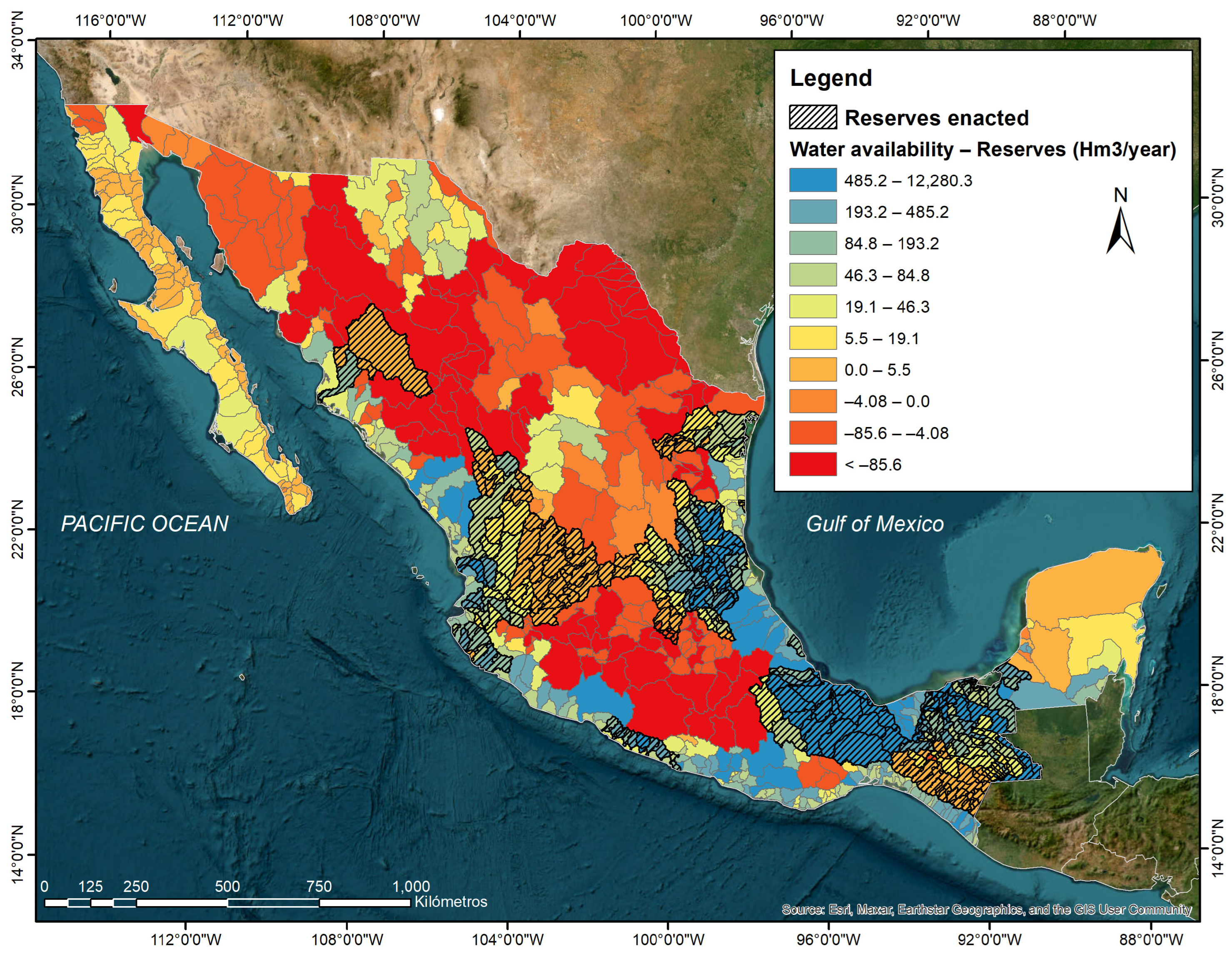
Figure 5.
Exploratory analysis of water availability volumes in million cubic meters based on reference values for ecological reserve by class of environmental flow objectives (A = blue, B = green, C = yellow, D = red). Focus on (a) central frequency distribution values within upper and lower limits (quartile 3 and 1 ± 1.5 times the interquartile range, respectively) and (b) outliers.
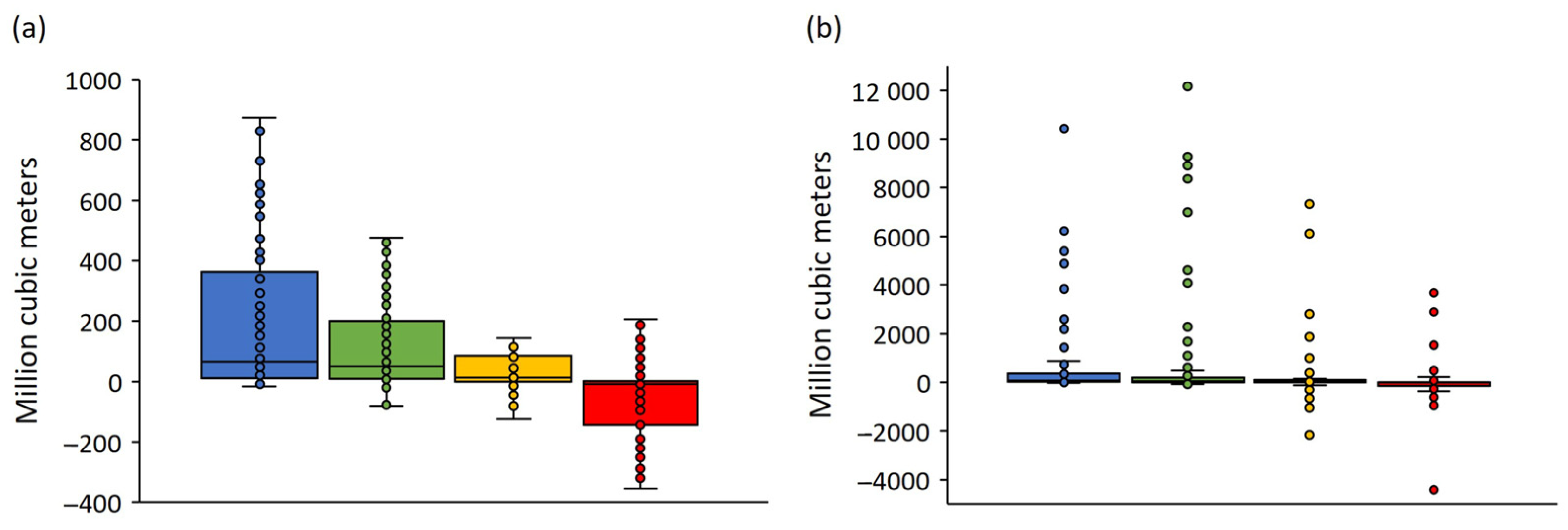
Table 2.
Variables, interpretation, criteria, and weighting factors for the feasibility assessment of potential water reserves. NPA: natural protected area; Bs: basin surface; Ids: irrigation district surface; As: aquifer surface; Dcv: dam capacity volume; Bmar: basin mean annual runoff (generated within the basin and the one coming from upstream). Source: elaborated by the authors from [11,13].
| Variable | Interpretation | Criterion | Value |
|---|---|---|---|
| Surface water availability (I) | Excluding | Availability < 0 Hm3 | (-.--) |
| Water stress | Excluding | Exploitation ≥ 10% | (-.--) |
| Surface water availability (II) | Positive | Volume > 0 Hm3 | 1 |
| Conservation value | Positive | Presence of Ramsar site Presence of a Federal NPA A total of ≥34 gaps and omissions of epicontinental aquatic conservation |
1 1 1 |
| Bans | Positive | Presence | 1 |
| Irrigation districts | Negative | Ids/ Bs ≤ 1% Ids/ Bs ≤ 10% Ids/ Bs > 10% |
0 –0.25 –0.5 |
| Dams | Negative | Dcv / Bmar ≤ 1% Dcv / Bmar ≤ 10% Dcv / Bmar > 10% |
0 –0.25 –0.5 |
| Risk of affectation to the basin from groundwater extraction (groundwater stress) | Negative | Low= As / Bs < 100% High= As / Bs < 1% High= As / Bs ≤ 10% High= As / Bs > 10% |
0 0 –0.25 –0.5 |
| Population density | Negative | Density ≤ 25 inhab / km2 Density ≤ 50 inhab / km2 Density > 50 inhab / km2 |
0 –0.25 –0.5 |
Table 3.
Number of basins by their level of feasibility as potential water reserves for ecological protection through time (2011-2022).
Table 3.
Number of basins by their level of feasibility as potential water reserves for ecological protection through time (2011-2022).
| Feasibility | 2011 | 2013 | 2016 | 2022 |
|---|---|---|---|---|
| Very High | 19 | 19 | 3 | 4 |
| High | 54 | 48 | 36 | 26 |
| Medium | 116 | 116 | 108 | 116 |
| Potential water reserve | 189 | 183 | 147 | 146 |
| Non eligible | 268 | 276 | 286 | 301 |
| Analyzed basins | 457 | 459 | 433 | 447 |
| Excluded basins | 271 | 273 | 298 | 310 |
| Total basins | 728 | 732 | 731 | 757 |
Table 5.
Number of basins for the evaluation of environmental flows in each level of pressure for water use, ecological importance and classification of environmental objectives through time.
Table 5.
Number of basins for the evaluation of environmental flows in each level of pressure for water use, ecological importance and classification of environmental objectives through time.
| Description | 2012 | 2016 | 2022 |
|---|---|---|---|
| Pressure for water use | |||
| Low | 423 | 387 | 399 |
| Medium | 68 | 64 | 76 |
| High | 34 | 35 | 33 |
| Very High | 207 | 245 | 249 |
| Ecological importance | |||
| Low | 174 | 182 | 170 |
| Medium | 262 | 252 | 292 |
| High | 230 | 227 | 236 |
| Very High | 66 | 70 | 59 |
| Environmental objective —Desired conservation status | |||
| D —Deficient | 156 | 144 | 219 |
| C —Medium | 304 | 276 | 106 |
| B — Good | |||
| A —Very good | 82 | 93 | 292 |
Table 6.
Number of basins by environmental objective with and without available water volume for the allocation of ecological protection reserves based on the use of reference values for water planning.
Table 6.
Number of basins by environmental objective with and without available water volume for the allocation of ecological protection reserves based on the use of reference values for water planning.
| Environmental objective —Desired conservation status | Surplus | Deficit | Total |
|---|---|---|---|
| D —Deficient | 88 | 132 | 220 |
| C —Medium | 79 | 26 | 105 |
| B — Good | 285 | 7 | 292 |
| A —Very good | 137 | 3 | 140 |
| Total | 589 | 168 | 757 |
Table 7.
Strategic and potential contribution of the water reserves and number of basins with environmental objective class “A” for environmental flow assessments, according to NMX-AA-159-SCFI-2012 on conservation objects dependent on the flow regime.
Table 7.
Strategic and potential contribution of the water reserves and number of basins with environmental objective class “A” for environmental flow assessments, according to NMX-AA-159-SCFI-2012 on conservation objects dependent on the flow regime.
| Conservation objects dependent on the flow regime | Current reserves (266 baseline) | Potential reserves (146) | Basins with a class “A” environmental objective |
|---|---|---|---|
| Federal Natural Protected Areas (km2) | 59,852 | 76,723 | 68,841 |
| Wetlands of international importance (km2) | 12,217 | 37,379 | 36,438 |
| Ecohydrological connectivity of free-flowing rivers at least in good conservation state (km) | 41,632 | 25,306 | 22,162 |
| Free-flowing rivers from source to mouth | 37,974 | 23,377 | 20,668 |
| Good conservation status | 3657 | 1930 | 1494 |
| Global ecoregions of aquatic ecosystems (km2) | 442,742 | 409,483 | 337,772 |
| Ameca – Manantlan | 23,632 | 16,292 | 11,939 |
| Chiapas – Fonseca | 455 | 14,762 | 8083 |
| Coatzacoalcos | 19,392 | 65 | 65 |
| Colorado | 0 | 6566 | 6566 |
| Cuatro Cienegas | 0 | 0 | 0 |
| Gila | 0 | 1492 | 1492 |
| Grijalva – Usumacinta | 69,325 | 46,010 | 44,030 |
| Guzman – Samalayuca | 39 | 5318 | 5318 |
| Lerma – Chapala | 4621 | 688 | 305 |
| Llanos El Salado | 8831 | 5231 | 5231 |
| Lower Rio Grande – Bravo | 23,469 | 7430 | 7240 |
| Mayran – Viesca | 16,741 | 44,297 | 21,505 |
| Panuco | 73,710 | 17,590 | 26,647 |
| Papaloapan | 50,337 | 15,691 | 10,732 |
| Quintana Roo – Motagua | 0 | 29,801 | 29,801 |
| Rio Balsas | 1706 | 2134 | 1296 |
| Rio Conchos | 743 | 259 | 0 |
| Rio Salado | 0 | 0 | 0 |
| Rio San Juan (Mexico) | 304 | 53 | 53 |
| Rio Santiago | 84,418 | 16,028 | 14,080 |
| Sierra Madre of the South | 8149 | 9372 | 4134 |
| Sinaloa | 34,175 | 17,112 | 13,428 |
| Sonora | 70 | 7888 | 319 |
| Southern California Coastal – Baja California | 0 | 70,311 | 50,415 |
| Upper Rio Grande – Bravo | 22,627 | 11,362 | 0 |
| Upper Usumacinta | 0 | 63,731 | 11,362 |
| Yucatan | 0 | 0 | 63,731 |
Disclaimer/Publisher’s Note: The statements, opinions and data contained in all publications are solely those of the individual author(s) and contributor(s) and not of MDPI and/or the editor(s). MDPI and/or the editor(s) disclaim responsibility for any injury to people or property resulting from any ideas, methods, instructions or products referred to in the content. |
© 2024 by the authors. Licensee MDPI, Basel, Switzerland. This article is an open access article distributed under the terms and conditions of the Creative Commons Attribution (CC BY) license (http://creativecommons.org/licenses/by/4.0/).
Copyright: This open access article is published under a Creative Commons CC BY 4.0 license, which permit the free download, distribution, and reuse, provided that the author and preprint are cited in any reuse.


