
Submitted:
27 December 2023
Posted:
28 December 2023
You are already at the latest version
Abstract
A Global Historical Megatsunami Catalog (GHMCat) is presented, including all the events documented to date. The oldest event is from 1674 the Santorini event, ~3600 BP, is considered a particular case, and the most recent is from 2020. Although there is no formal definition of the term megatsunami, it is usually associated to the maximum height or runup reached by the waves when hitting the coast. Here we adopt this criterion and define a megatsunami when the wave reaches a height of 40 m or more. The catalog is initially based on tsunamis that meet this condition from the two existing Global Historical Tsunami Databases (GHTDs). Then, each of the events have been researched for its available references including earliest in order to verify the data, mainly on the maximum height of the waves and their causes. After a comprehensive review of published or on-line literature on historical tsunamis, including regional and local catalogs, papers, books, studies, reports and other available references, some of the oldest events have been ruled out. On the other hand, the literature review has also led to include in the catalog some new megatsunamis not included in the GHTDs. The global catalog contains 37 events from 1674 to 2023, 11 of which are either not included in the GHTDs or included with (erroneous) wave heights <40 m. All of them are described and characterized as far as can be gathered within the limitations of the scope of a global catalog and the available information on each historical case. The analysis of recorded historical megatsunamis shows that virtually all have been originated by large landslides, most of them subaerial landslides, with an unusual frequency of events in certain glaciated areas of Alaska and Norway, mainly in the first decades of the 20th century. In contrast, it is worth noting the small number of megatsunamis caused by submarine landslides or associated with volcanic explosions.
Keywords:
megatsunamis
; Tsunami catalog
; historical megatsunami catalog
; Alaska Tsunamis
; Norway Tsunamis
1. Introduction
The comprehensive megatsunami global catalog here presented describes for the first time all known historical megatsunamis that have been documented by historical records or geological evidence (i.e. measurements and field observations).
Some previous studies present lists of "large tsunamis” compiled for specific areas or time intervals [1], and partial lists of landslide-generated "giant waves" or “large waves” have also been published [2,3,4,5,6].
Historical tsunamis are those documented through written records from eyewitnesses or direct observations and measurements. The number of megatsunamis known from historical documentary references or deduced from geological evidence is very limited, the oldest of which can be said to be that caused by the great explosive eruption on the island of Thera or Santorini in Greece around 3600 BP.
Undoubtedly, many megatsunamis must have occurred on Earth in historical times, far beyond the few records available, but they were neither observed nor reported. Also, throughout the earth’s history these processes must have been relatively frequent, although both because of the short period of historical record and the fact that most of their effects have disappeared from the face of the earth, we can only access a few records.
Megatsunamis, or giant waves, are extreme unexpected processes that strike the earth’s cliff shores in any geological or climatic region, as they are not related to any specific conditioning factor, but to the presence of a water body and the occurrence of a geological triggering-process, most often a large subaerial landslide. The term, even without a clear, agreed definition, has been widely used in scientific publications in the last decades, mainly in relation to prehistoric oceanic tsunamis associated with large bolide impacts and giant volcanic island flank collapses [7,8,9,10,11]. It has also been applied to the extensive and destructive seismic tsunamis of 2004 Indonesia and 2011 Japan, and earlier events such as the 1946 Aleutians, 1960 Chile and 1964 Alaska oceanic tsunamis [1].
However, the most agreed and appropriate definition of a megatsunami refers only to the maximum height reached by a wave on land ‒or runup‒, the extent and impact of the tsunami being irrelevant. On this basis, a megatsunami can be defined as a giant wave, with a height of 40 m or more, as established in this study.
Megatsunamis are always local events, originating from a nearby source, which effects are confined to a small area, as the height of the waves rapidly decreases as they move away from their source. Opposite to “conventional” or “normal” tsunamis resulting from offshore earthquakes, megatsunamis reach very large heights when hitting the coast, with maximum runups observed or measured of several hundred meters on the shores of confined marine or inland bodies of water, such as lakes or reservoirs.
Most of historical megatsunamis have been generated by large subaerial landslides, and only a few cases are related to violent volcanic eruptions. Landslide-generated tsunamis are the largest due to the kinetic energy of huge rock masses falling from considerable heights and violently entering bays or lakes; landslides are sometimes triggered by large earthquakes, and often occur in confined bodies of water, bays or lakes. Megatsunamis caused by subaerial landslides have been recorded since the 18th century in Norway and Japan.
Among the problems associated with historical information, are those derived from the inaccuracy and incompleteness of the data mainly about old or geographically remote events, and errors in the interpretation of old descriptions and conversion of old units of measurement for wave height.
From 1674 to 2023, a total of 37 megatsunamis (i.e. those with wave heights > 40 m) have been included in the Global Historical Megatsunami Catalog (GHMCat), after a thorough investigation of the available documentation −more than 280 publications between 1888 and 2023 have been consulted−. For some of these, extreme heights in excess of 100 m have been reported.
Although only a few records from the 19th century have been properly characterized, during the 20th century the number of recorded events has increased significantly, and in the first 20 years of the 21st century alone the same number of cases has been recorded as for the 20th century. It is clear that the record of large tsunamis increases as scientific knowledge develops along with industrial development from the second half of the 19th century and especially in the 20th century.
To the list of cataloged events, a new undocumented megatsunami has been added from the review of old Alaskan explorers’ documents from the late 18th century: a megatsunami prior to 1786 in Lituya Bay [12]. However, it has not been included in the GHMCat as its year of occurrence is unknown, and we can only establish its upper limit.
The GHMCat presented here brings together all the historical events recorded so far, and provides for the first time the whole list of events and information on the causes and significant effects, damages or casualties, when available.
Data on maximum recorded wave heights, their causes and effects are important for understanding the frequency and distribution of the phenomenon, its generation and potential risks and harmful effects, and can contribute to prevention and mitigations tasks.
2. What is a megatsunami?
2.1. Definition and background
A megatsunami is a giant wave. Although there is no formal definition of megatsunami, there is a general consensus based on the maximum height reached by the wave when it hits the coast, as this seems to be the more useful and used parameter to differentiate between megatsunami and “normal” (seismic) tsunami waves. The former can therefore be defined as a tsunami, or a wave, that reaches or exceeds a certain height when hitting the coast; however, there is no specific wave height or threshold above which the term "megatsunami" can be applied.
The term megatsunami was first used in scientific literature around 1990 [13] in connection with the giant waves (“mega-tsunami”) caused by the impact of a huge asteroid in the Gulf of Mexico millions of years ago, at the Cretaceous-Paleogene boundary, which left characteristic coarse-grained deposits throughout the region. Previously, Bourgeois et al. [14] referred to wave heights in the range of 50 to 100 m for this paleotsunami, using the term "very large tsunami".
Another early reference appears in Paskoff [15], in reference to a possible "mega-tsunami" to explain the presence of large boulders embedded in shelly beach deposits on an elevated marine terrace up to 40 m a.s.l. on the Chilean coast; tentatively, the cause of the tsunami was associated with an earthquake of exceptional magnitude during the Plio-Quaternary. Previously, the term "giant wave" was used to explain the origin of high marine coarse deposits on the island of Lanai, Hawaii [16,17]: according to their elevation, the waves must have reached between 190 and 375 m high, and probably were originated by a huge submarine landslide. The same term “giant wave” was used earlier [2] to describe the waves of a tsunami generated by a large rockslide in 1958 at Lituya Bay, Alaska.
With regard to the threshold height value reached by the waves to be classified as a megatsunami, few publications provide specific values. Some authors have subjectively provided minimum wave height values of 40 or 50 m a.s.l., or even 100 m; others, from several tens to hundreds of meters high.
Alexander and Neall [18] point out that megatsunamis are above 40 m, and up to hundreds of meters, while “normal” tsunamis have heights of up to about 10 m; according to Krehl [19], mega-tsunamis are defined in the literature as waves over 100 m high, even over 300 m, although the author does not include any bibliographical reference. These and other references are compiled by Goff et al. [20] in a text focused on the definition of the term "mega-tsunami", finally proposing a definition based solely on initial wave height/amplitude at source exceeding 100 m/50 m respectively; thus, only including those extreme events on geological timescales generated by large bolide impacts, extremely violent volcanic activity or giant landslides, and possibly an extreme submarine earthquake not yet historically documented.
In the same way, Naranjo et al. [21] define the term megatsunami as a tsunami with an initial wave amplitude or height of several tens or hundreds of meters, well above a "normal" tsunami; most have been caused by major impacts, such as large-scale landslides, devastating volcanic eruptions or meteorite strikes, while normal tsunamis are caused by tectonic activity that violently displaces the seabed.
The authors do not agree with those definitions based on the initial wave height at source, as a tsunami means a wave that reach or hit the coast, and inevitably the height it can reach is influenced by near-offshore bathymetry and onshore topography and geomorphology (e.g. cliff coasts versus flat coasts). Thus, the most objective parameter to define a megatsunami would be the maximum height reached by the waves at any point of the affected coast. The term most commonly used to refer to this parameter is vertical runup or just runup. The maximum horizontal distance on land (inundation or horizontal runup) is not considered in the definition of megatsunami. Both values depend largely on the elevation and orography of the coast.
According to UNESCO [22], and other publications [23], runup is the difference between the elevation of maximum tsunami penetration inland and the sea level, and can be only measured where there is clear evidence of the inundation limit on the shore. This definition is clearly aimed at “normal” seismic tsunamis on flat coasts, where the maximum wave height on land occurs at the maximum inundation distance. However, especially in the case of megatsunamis, there could be waves higher than those corresponding to the maximum inundation limit, i.e. when the wave hits a local rocky cliff, splashing and reaching an elevation higher than that at the point of maximum inundation distance.
In order to clarify the term and its meaning, the most useful definition for runup is the maximum height the wave reaches onshore above a reference level, usually mean sea level. Runup can be observed or measured after the tsunami. At present, rigorous measurements of the largest tsunami waves are carried out through post-tsunami field surveys, looking at the marks left by the waves on the coast. Maximum runup height can be inferred from the vertical limit of vegetation washed away by the wave, marks on wooded hillsides, damage to trees or debris deposited on hillsides or on trees.
According to Goff et al. [20], the term megatsunami has been arbitrarily used in a variety of settings, to mean not only large waves at the source of the event or on land, but also geographically extensive tsunamis (such as the 2004 and 2011 ocean-scale tsunamis) with or without giant waves. Gusiakov [1] refers to “catastrophic trans-oceanic mega-tsunamis affecting an entire oceanic basin…”, listing seven occurred within the last 77 years, resulting from large subduction earthquakes, with maximum runup heights between 23 m and 67 m (one of them caused by the largest earthquake in recorded history, the 1960 Chile earthquake, with maximum wave height between 12 and >20 m, depending on the source).
Both the geographical extent (even on an oceanic scale) and the impact or destruction caused by the waves in coastal areas are irrelevant to the definition of a megatsunami, based solely on the height of the waves on land. In fact, megatsunamis are always local events, originating from a nearby source, which effects are confined to a small area; maximum runups are focused along a limited length of coast −not exceeding some tens of kilometers at most, against the hundreds of kilometers that a tectonically-induced tsunami can reach [5]− and decreases rapidly with distance. Near-field runup can be many times higher than that produced by seismic tsunamis, and can reach hundreds of meters in exceptional circumstances.
Literature references including lists of megatsunamis or large tsunamis are very scarce. A compilation of “large tsunamis” collected from the two existing global historical databases (GHTDs) for the period 1900-2019 is presented by Gusiakov [1], based on the annual maximum runups observed or measured (Figure 1), of which 17 events exceed or equal 40 m in height; according to their sources most of them have been landslide-generated. A list of data on localized “giant waves” generated by subaerial landslides is presented by Miller [2], and partial lists have also been published [3,4,5,6].
2.2. Megatsunami wave height threshold
After a comprehensive review of the literature and available data on the largest historical tsunamis, a megatsunami is considered here when the waves reach or exceed 40 m in height on land with respect to the mean water level (sea, lake, river); the height may correspond to any type of recorded observation: maximum height reached by the wave on land (runup height), marks left by the violent impact of the wave, or others. This lower limit is considered here as the most representative, as it differentiates an elite group of about thirty cases in the GHDBs originating from geological processes other than earthquakes, thus maintaining the exceptionality to which the term itself implicitly refers. The 40 m threshold corresponds to the lowest of those proposed for megatsunamis by different authors. If a lower limit (i.e. 30 m) were considered, the group would include many other cases mostly related to earthquakes; approximately 1.5% of all historically tsunamis of any origin documented in the GHTDs are assigned a runup ≥30 m, and 1% ≥40 m, none of them directly caused by an earthquake. Some threshold above, e.g. 100 m, would only include an elite group of 6 or 7 events of those included in the GHTDs.
A remark should be made concerning what is considered the maximum height reached by the water: this data is always punctual, and is not representative of the medium, even the maximum, height of the waves reaching the coast, and can sometimes correspond to the surge or splashes of the waves or seiches that are generated by the movement of the water in confined bodies of water. E.g. for the 1958 Lituya Bay megatsunami, a maximum runup of 525 m was measured in situ at the highest point where the surge of water reached after hit a steep slope and splash to very high elevations, this being the value assigned to this megatsunami. However, some authors differentiate between this local runup and the maximum wave height reflected on the slopes more extensively, ~150 m, or the maximum wave amplitude, ~50 m [23].
Measurements on cliffs or steep coastlines may give high local runup values, very different from the maximum wave heights reached in the surrounding areas. In the case of the Indonesian tsunami in 2004, the maximum runup of 50-51 m measured west of Banda Aceh, northern Sumatra [24,25] corresponds to the height of the vegetation washed away by waves on the cliff walls of a small isthmus; this value is considered to be the highest ever measured for a tsunami directly attributed to an earthquake (actually for a non-landslide tsunami), although given its very local nature it cannot be considered representative of the tsunami; in fact, some authors [24,26] give maximum wave heights of about 35 m for the same area, the most affected by large waves, differentiating between maximum waves heights and maximum point runup height due to the particular orography of the coast.
2.3. Causes of megatsunamis
Megatsunamis are caused by the impact of large-scale landslides, gigantic explosive volcanic eruptions and large asteroids on the sea or confined bodies of water, while “normal” tsunamis ‒seismic sea waves‒ are caused by tectonic activity that violently displaces vertically the sea floor and the water column above. In contrast to large seismically-generated tsunamis, megatsunamis are local processes, as the height of the waves rapidly decreases as they move away from their source; according to Lander [23] “Large breaking waves … are rare and almost unheard of outside of the generating area.”
Because the probability of occurrence of these large-scale geological processes is low, that is also the probability of occurrence of megatsunamis around the world. Prehistoric volcanic-island-flank landslides, the largest ever to have occurred on Earth (with a volume of several hundred km3), originated megatsunamis up to several hundred meters high, according to geological evidence from deposits left by the waves on the coasts [7,8,9]. No volcanic island megalandslides or asteroid impact have occurred in historical times.
Most megatsunamis are caused by subaerial landslides and rock avalanches on the slopes of confined bays and fjords and, to a lesser extent, on lakes, reservoirs and rivers.
The exact origin of megastunamis associated with large earthquakes has been (, and remains in some cases, controversial. While for some researchers they are generated by large submarine landslides triggered by the earthquake, for others it is the rupture mechanism of the fault itself the origin of the giant waves; these megathrust earthquakes occur at convergent plate boundaries, and are called “slow tsunami earthquake” or “tsunami earthquake” because of their potential to generate large tsunamis. In the first case, evidence of landslides can only be obtained by marine geological and geophysical surveys, as has been the case for several historical megatsunamis initially attributed to earthquakes [23,27,28].
First evidence of a large earthquake-triggered underwater landslide was during the 1929 Grand Banks earthquake (M 7.2), North Atlantic, after numerous undersea telegraph cables were broken as a result of major mass movements downslope. In the more recent 1998 Papua New Guinea earthquake (M 7.1) a submarine landslide was inferred from a variety of evidence [29]. Both underwater mass movement generated waves of up to 13-15 m in height on the nearby coasts, disproportionate to the magnitude of the earthquakes, i.e. earthquakes were too small to generate the recorded tsunami waves. Before the 1998 event, it was questionable as to whether a submarine landslide could cause large tsunamis.
Local megatsunamis generated by submarine landslides far exceed the height of the main −more extensive− tectonic tsunami, and reach the coast within a few minutes after the earthquake; both superimpose on the shores near the origin of the earthquake.
3. Methods
The compilation for the megatsunami catalog is initially based on the information on maximum runup heights collected in the Global Historical Tsunami Databases (GHTDs), where, in a first step, the events that meet the requirement imposed on the minimum wave height reached on land were selected.
From this initial list each event was researched for its available references including earliest. The information on megatsunamis has subsequently been cross-checked with data from the documentary sources. Some of the most outstanding events are well documented and described in papers and reports, while others are poorly documented, in some cases on a single publication. Also, a systematic search for “new” events not included in the GHTDs was undertaken. Additional contemporary documentary sources were sought, principally scientific papers and technical reports published or on line.
3.1. Data collection
Initial data were selected from the two existing online Global Historical Tsunami Databases (GHTDs):
- NCEI/WDS Global Historical Tsunami Database [30] supported by the National Geophysical Data Center of the National Oceanic and Atmospheric Administration (NOAA), USA.
- TL/ICMMG Global Historical Tsunami Database [31] supported by the Tsunami Laboratory, Institute of Computational Mathematics and Mathematical Geophysics of Siberian Division of Russian Academy of Sciences, Russia.
Both have been compiled from historical tsunami data mainly from earlier regional catalogs and studies, local catalogs and other old and contemporary scientific sources, individual event reports and studies, and unpublished works and documents, all with different spatial and temporal scope. The two databases are generally consistent in terms of data format and content (about 100 events from each database are not recorded in the other), with some differences in the estimates of maximum water heights (runups), confidence level or degree of validity assigned, or attribution of tsunami sources or causes, mainly for older historical events.
The American and Russian databases collect available and documented information on both the geological processes generating the tsunamis (tsunamigenic events), mostly earthquakes, and on the maximum wave heights observed or measured in all locations where data are available. The detail and veracity of the data depends on the sources and, above all, the date of occurrence. The period of record covers the last 4 centuries. Since the beginning of the 20th century, there has been a notable increase in the number of records and observations, which has been accentuated since the 1960s and especially since the beginning of the 21st century, coinciding with the great tsunami in Indonesia in 2004, from which scientific research and publications have intensified.
The NCEI/WDS database contains information on over 2800 tsunami events (of which 1269 include measured or estimated runup or wave height data, 706 of these with heights >1 m) in the Atlantic, Indian, and Pacific Oceans, and the Mediterranean and Caribbean Seas, from 2000 BC to the present (2023). The TL/ICMMG database includes information on 2700 events (of which 1128 include some wave height or runup data and, 619 with heights >1 m) occurred in the World Ocean, for the same period of time. Both computerized, easily accessible databases can be kept constantly updated.
Most of the tsunamis have been generated by submarine earthquakes (~80%), especially those prior to 1500; the rest are associated with landslides (~9%), volcanic eruptions (4%-5%) and meteorological effects (2%-3%). Tsunamis caused by landslides have been recorded since the 17th century, increasing in number by the 20th century, especially from the 1960s onwards.
Of all historically documented tsunamis of any origin, approximately 1.5% have reached or exceeded 30 m wave height, and only 1% have reached or exceeded 40 m, none of them directly generated by an earthquake.
The main uncertainties when dealing with historical information come from the temporal and spatial biases in their recording, and the validity of the data. The limitations and problems of existing tsunami catalogs and databases are described by Gusiakov [32]; among the problems are those derived from the inaccuracy and incompleteness of the data mainly about old or geographically remote events, and the errors in interpretation of old descriptions. One way of indicating these uncertainties in tsunami databases is the assignment of a validity index, generally ranging from 0 or -1 (false or erroneous) to 4 (definite).
3.2. Literature review
The literature review was carried out with a dual purpose: on the one hand, to verify megatsunami data, mainly runup and source, collected from the GHTDs databases; and on the other hand, to search for megatsunami events not included in the databases.
For these purposes, references cited in the GHDBs have been reviewed, as well as any other information on a specific megatsunami event, even searching, where possible, for its earliest references. Numerous regional and local catalogs, scientific papers, published case studies and reports, books and any other reliable source of information, including available on-line old catalogs and documents with original data, and personal consultations with expert researchers. More than 250 publications between 1888 and 2023 have been reviewed, some of which include references to 17th and 18th century written reports, the oldest in 1675 [33] and ~1750 [34]. Old records are often unclear and incomplete, mostly written long after the event by those who were not eyewitnesses. Occasionally, the dates of older events may not correspond exactly in all bibliographic sources, as there have been some adaptations of the calendars used in ancient sources.
More than a hundred regional or local tsunami catalogs are available since the mid-20th century, and some even earlier. A detailed description of these information sources and their contents and evolution, since the appearance of the first catalogs in the 1930s and 1940s, as well as the development of the two global historical databases since the 1980s and 1990s, is provided by Gusiakov [32].
The website of the Tsunami Laboratory of the ICMMG of Russia include a list with more than 120 published historical tsunami catalogs (http://tsun.sscc.ru/tsu_catalogs.htm). Wiegel [35,36,37] has published a comprehensive list of tsunami information sources worldwide, including all available catalogs up to the time of his publications. More recently, Cheng et al. [38] have published a detailed comparative study of the content of existing global databases.
The first historical tsunami catalog was compiled by N.H. Heck in 1934 [32] who summarized the tsunami data from previous earthquake catalogs. Initially published in French, it was published in English in 1947 [39], undoubtedly linked to the 1946 Aleutian tsunami that caused damage and losses of life at Hilo, Hawaii and further damage on shores of the Pacific Ocean. It contains 270 waves, classified under the terms of "seismic sea wave," "sea wave," "tidal wave," and "tsunami"; wave height data are not included.
Listed below are some of the most comprehensive and representative catalogs of historical tsunamis data and additional information, that include some of the megatsunamis referenced in this study:
- Iida, K., Cox, D.C. & Pararas-Carayannis, G. 1967. Preliminary catalog of tsunamis occurring in the Pacific Ocean [40].
- Soloviev, S.L. & Go, Ch.N. 1974. A catalogue of tsunamis on the western shore of the Pacific Ocean (173-1968) [41].
- Soloviev, S.L. & Go, Ch.N. 1975. A catalogue of tsunamis on the eastern shore of the Pacific Ocean (1513-1968) [42].
- Iida, K. 1984. Catalog of tsunamis in Japan and its neighboring countries [43].
- Lander, J.F. 1996. Tsunamis affecting Alaska 1737-1996 [23].
- Harris, R. & Major, J. 2016. Waves of destruction in the East Indies: The Wichmann catalogue of earthquakes and tsunami in the Indonesian region from 1538 to 1877 [44].
3.3. Data verification
The selected events (all with runup ≥40 m) from the GHTDs were researched in order to obtain as much information as possible about the sources and validity of the data, looking for historical evidence to verify and check the maximum runup provided by the databases, as well as the causes of the events. The main goal has been to check the information with reliable historical data or evidence. In general, for megatsunamis recorded over the last century, the data on the maximum height reached by the waves on land are reliable and supported by evidence. The review process led to rule out some of the initially selected megatsunamis due to lack of evidence or significant uncertainties or doubts, as it was not possible to verify the data, mainly older historical events before the 19th century; but it also led to identify some events that initially did not meet megatsunami criteria here imposed, as well as other megatsunamis occurred in the last decades not included in either GHTDs.
4. Results
The final global catalog of megatsunamis consists of those verified megatsunamis from the group initially collected from the two GHTDs (all with a wave height ≥40 m, regardless of the origin assigned) and those events, not included in the GTDBs, selected after the documentary research carried out. As a result, a total of 37 historical megatsunamis have been compiled (excluding Santorini).
In addition to the maximum wave heights, the exhaustive review has also made it possible to define their causes, especially in the oldest cases for which new documentary and field research has been carried out.
4.1. Megatsunamis included in the GTDBs
The NCEI/WDS and the TL/ICMMG GHTDs include 29 and 27 megatsunami events −i.e. with reported maximum water height ≥40 m−, respectively, for the period 1674-2023, of which 25 coincide in the two databases. The oldest event documented is from 1674 (excluding Santorini, 3,600 BP): a huge wave ~100 m high, the largest ever documented in Indonesia, generated after a violent earthquake, affecting the north coast of the island of Ambon; the earthquake and tsunami caused more than 2,300 casualties. All of the events are classified as definite −the highest level of validity of the actual tsunami occurrence− in the GHTDs, although there are sometimes large differences in the maximum wave height or runup reached by the waves.
The volcanic tsunami of the island of Thera or Santorini, in Greece, around 1600 BC, is included in both databases, although only the NCEI/WDS gives a maximum wave height of 90 m. The historical evidence of a large tsunami caused by the explosion and collapse of the island are indisputable. Wave heights have been estimated at between 40 and 90 m according to geological evidence, although could have exceeded 250 m in height [45,46]. This event has not been included in the global catalog of megatsunamis presented here.
Data on these megatsunamis are presented in Table 1, as of 16 October 2023; the latest recorded event is from 2020. A total of 32 megatsunamis have been compiled. Few megatsunamis (6 events) have reached or exceeded 100 m in heigh. The apparent accuracy of some of the older runup figures is due to the precision used for unit conversions to the metric system, especially for old events.
Most of the megatsunamis in the American database, 22 of the 29 total events, are assigned a landslide origin (6 of them triggered by earthquakes and 3 by volcanic eruptions), 3 are attributed to volcanic eruptions and 4 directly to earthquakes. In the Russian database, 19 are attributed to landslides (5 of them triggered by earthquakes), 2 to volcanic eruptions and 6 to earthquakes.
4.2. Definitive megatsunamis
The review of documentary sources on the megatsunami events initially listed from the GHTDs (31 events not including Santorini) has led to discarding 5 of them due to reasonable doubts, uncertainties or contradictions in the data provided for the maximum height, or runup, reached by the waves. On the other hand, the extensive literature review has also led to the inclusion of some events not listed initially as megatsunamis, and some other significant events, mainly from the mid-1980s, not recorded at all in the GHTDs, thus increasing the catalog of megatsunamis significantly.
As a result, a total of 37 historical megatsunamis have been finally compiled, 26 of which are included in the two GTDBs, while 11 are new events. These are listed by year in Table 2, including their maximum runup height and cause. Figure 2 shows the distribution of megatsunamis by year and runup height.
4.2.1. Verification of old megatsunamis from the GHTDs
The following events have been discarded: 1737 (Russia), 1741 and 1771 (Japan), 1788 and 1880 (Alaska); all but the last occurred during the 18th century. For three of these ancient events, only one of the global databases provides wave heights >40 m, based on oral references in old documents (see Table 1): the earthquake-triggered tsunami of 1737 in the Kuril-Kamchatka region; the tsunami of 1741, caused by a large volcanic landslide on the island of Oshima-Oshima; and the 1880 tsunami by a seismic landslide in Alaska. In all cases, there is a large difference between the wave heights provided by the two GHTDs.
The maximum runup heights, between 63 and 100 m, for 18th century tsunamis attributed to earthquakes (1737, 1771, 1788) are not very reliable, as they come from ancient observations not confirmed by subsequent geological investigations or historical evidence. Besides, such heights have never been observed for tsunamis caused by even very high magnitude earthquakes. Some recent scientific papers review these data, considerably lowering the wave heights, in some cases well below those recorded in the global databases.
The maximum runup of the October 1737 event provided by the Russian global database was based on reported heights of driftwood and trees washed over a cliff, not definitively linked to the tsunami (Lander, 96). Some of the available documentary sources report very different data on the maximum height reached by the waves: 63 m according to written testimonies of the time following an expedition in 1738 [34,47], and 8-10 m according to a study of field data and written sources on this tsunami [48]. No definitive conclusions can be drawn for the 1737 earthquake-triggered tsunami, which also affected Alaska with a maximum wave height of 12-15 m. According to Lander (96), the maximum waves in Kamchatka reached 30 m.
The April 1771 tsunami, known as the Great Meiwa Tsunami ‒with 12,000 deaths‒, reached maximum wave heights of up to 85 m according to some available documentation. Recent publications indicate a more reliable maximum value of around 30-35 m (30 m [49]; 32 m [50]; 30 m [51]; 30 m [52], in any case <35 m; ≤35 m [53]), discarding older data from historical record considered over-estimated, such as the maximum height of 85 m in the southern coast of Ishigaki Island from a historical record just after the disaster [43,54]. Soloviev and Go [41] attribute these differences to confusion in the conversion of units of measure of length at the time.
The source of the 1771 tsunami has been attributed to a M 7.4 earthquake, and alternatively to an earthquake-triggered landslide, based on submarine geological evidence [51]. According to Matsumoto et al. [54], since no historical record of tremor was identified that corresponds to the Great Meiwa Tsunami, it might be reasonable to consider a large-scale underwater landslide as the origin of the tsunami.
The 6 August 1788 tsunami, the earliest recorded tsunami in the Aleutian-Alaskan trench region, Gulf of Alaska, is attributed to a M 8 earthquake in both GHTDs. The maximum runup of 88 m at Unga Island or Sanak Island is very doubtful and not documented [23], coming from oral testimonies of the period, published several decades later [55]. According to [55] and [23], the maximum height reached could be 30 m or “few tens of meters” on Unga and Sanak Islands, and could not be attributed solely to displacement of the seabed by tectonic failure; in fact, old reports cite that the earthquake caused landslides from the mountains and shores [23].
Due to the above considerations, particularly since the maximum wave heights cannot be verified in the absence of reliable historical records, the seismic tsunamis discussed above cannot be considered megatsunamis.
The 26 October 1880 Alaskan tsunami reached a maximum wave height of 60 m and 1.8 m in Sitka, according to the Russian and American GHDBs respectively, the former without citing the source of the data. Both include other tsunamis associated with the same earthquake (estimated M 6.3) with runup not exceeding 2 m; also, the events are classified as "probable", not definitive. According to [23], based on information from newspapers of the time, the cause of the unusual waves was “very local submarine landslide-generated tsunamis", with maximum height of 1.8 m, although the author also makes the following comment: "huge wave ran into bay", without specifying further. According to [42], a “large tidal wave appeared” after the earthquake. This contradictory and inconclusive data, together with the fact that the supposed 60 m wave is located in a bay more than 200 km from where the other smaller tsunamis were recorded, seems to indicate that the runup height is erroneous.
The 1741 tsunami was caused by a landslide on the north flank of the small Oshima-Oshima volcanic island in the Sea of Japan, SW of the island of Hokkaido. Historical records refer to the existence of volcanic activity, but do not record the occurrence of any earthquakes. The landslide, of about 2.4 km3, one of the largest landslides in history, affected the subaerial and submarine flank of the island. The 90 m maximum wave height for the tsunami is not supported by evidence; it appears in the NOAA database and originally comes from the Catalog of tsunamis in Japan and its neighbouring countries [43] where only an oral reference is given. According to reliable historical documents the maximum runup was 13 m, while data providing higher heights are oral and unverified [56]. According to the Russian database and other review catalogs and literature sources, the maximum wave height reached about 9-10 m off the coast of Hokkaido [40,41,56]. Therefore, this event cannot be described as a megatsunami.
After ruling out the 1741 tsunami, there are only 2 documented historical cases of megatsunamis from volcanic island flank landslides: on Mount Mayuyama, 1792, Japan, and very recently on the island of Anak Krakatau, Indonesia, 2018.
The most recent large volcanic island flank landslide, although not causing a megatsunami, occurred on Ritter Island (Papua New Guinea) in 1888, with a volume of ~2.4 km3 similar to Oshima-Oshima, both being the only two large-volume (>1 km3) flank landslides historically recorded on volcanic islands, ranking among the largest historical on Earth. The Ritter landslide generated a tsunami with maximum runup of 15 m along the nearby coastline [57].
4.2.2. New documented megatsunamis not included in the GHTDs
Eleven “new” megatsunamis have been added to the elite group of megatsunamis after a comprehensive review of the corresponding documentary sources (Table 3):
- 7 are not recorded in the GHTDs: 2 in 1936 in Norway; 1985, 2003 and 2018 in China; 2007 in Mexico; and 2020 in Canada.
- 4 are recorded in the GHTDs with runup values <40 m: ~38 m for the 1756 Norwegian, 1896 Japanese and 2007 Canadian events; and runup of 9 and 30 m for the 1946 Canadian tsunami. The first 3 are the only events in the GHTDs with runup >35 and <40m.
The events are listed in Table 3, with the final runup values assigned after review of the corresponding documentary sources, described in the GHMCat. All but two have runup heights above 40 m. For the 2007 tsunami (Canada), the maximum runup height of 38 m is definitive from a post-tsunami field survey and, as it is the only one with runup <40 m, it has been considered for inclusion in the global catalog of megatsunamis. The same criterion has been applied for the “new” event in 2003, in China, with a 39-m runup.
4.3. A new event in Lituya Bay prior to 1786
Lituya Bay, on the northeast shore of the Gulf of Alaska, was officially discovered by La Pérouse in 1786, during his expedition around the world. Cenotaph Island, a large wooded mound at the center of the bay, is named for the 21 members of the La Perouse expedition who drowned after three small boats capsized in rough seas at the shallow entrance to the bay. A monument was erected in their memory on the island.
The bay is currently well known for having experienced the highest wave runup ever recorded (525 m), and for being one of the two places on earth where the largest number of megatsunamis have been recorded since the mid-19th century: at least four megatsunamis during a little more than a century (1853, 1899, 1936 and 1958) have rushed out from the head of the bay; all except the 1899 event are among the ten largest historical megatsunamis in the world, with more than 100 m. In all cases, the megatsunamis destroyed the forested slopes leaving clear markers of the corresponding runup heights reached. Another tsunami, with runup of 20-30 m, occurred around 1874, as deduced from the trimline identified in a photograph of 1894 of the north shore of the bay and observations of the stage of vegetation growth below and above the tsunami trimlines [2]. These old marks left by the waves on the vegetation of the slopes, were largely erased in the 1936 megatsunami, and almost completely in the 1958 event.
The review of historical documents for this study has led to infer the occurrence of another megatsunami prior to 1786 in Lituya Bay [12]: an engraving of the bay made in the summer of that year by the expedition of the frenchman La Pérouse, its official discoverer, clearly shows the effects of huge waves on the slopes of the bay, with the vegetation completely washed away up to a certain height, several tens of meters above sea level (Figure 3) [58]. In the image below there is even another lower trimline, clearly visible on the right-hand slope, which could represent a lower tsunami; and, what is definite evidence of the occurrence of megatsunamis prior to 1786, a large rockslide on the cliff at the bottom of the bay can be observed, in the same area where the earthquake-triggered rockslide of 1958 occurred.
The details of the drawing undoubtedly indicate that both processes must have occurred not long before the arrival of the expedition. Since the Lituya Bay history begins very briefly in 1786 (La Perouse expedition) or 1788 (Russian exploration and settlement) there are no records available to collate the occurrence of a megatsunami in earlier years. However, it can no longer be maintained that the oldest known megatsunami in Lituya is that of 1853.
The high frequency of megatsunamis in the bay (at least five since the mid-18th century), compared to other similar bays in the area, may be partly due to the presence of a large coastal fault, the Fairweather Fault, with very significant seismic activity: the 1958 megatsunami, and most probably the 1899 megatsunami, were caused by rock and ice avalanches triggered by earthquakes [2,23]. The inferred megatsunami prior to 1786 cannot be associated with a significant earthquake as the history of Alaska can be said to begin in 1784, when the first Russian settlements were established, four years before than a Russian ship entered Lituya Bay to claim the territory; in fact, the earliest earthquake and associated tsunamis ‒in July 1788, two years after the La Pérouse visit‒ in the Aleutian-Alaskan trench region were recorded by a Russian missionary in 1940, describing “very strong earthquake” and “terrible floods” [23,55].
4. Global Historical Megatsunami Catalog (GHMCat) 1674-2023: Description of events
- 1674, February 17 - Ambon Island, Indonesia
- Runup: 100 m
- Cause: Submarine? earthquake-triggered coastal landslide
The Ambon earthquake of 1674*, one of the most historical damaging earthquakes in the Moluccan archipelago, and the most violent that the island of Ambon had experienced, was followed by a large tsunami reaching runup heights of up to 100 m in the northern coast of the island, based on the distinctive coastal vegetation trimline it left.
It was the first documented tsunami in Indonesia, with detailed descriptions in a text written by the German botanist and naturalist Rumphius in 1675 [33], and the largest runup height ever recorded in the country. The ancient documents refer to the occurrence of large coastal landslides on the north shore of Ambon as a consequence of the earthquake, causing waves up to 90-110 m high [41,44]. Part of the coast slid into the water, carrying with it whole villages and coastal hills plantations and vegetation, killing more than 2,500 people.
Witnesses accounts provided detailed descriptions of the events: “the water rose up like a mountain … carrying with it trees, houses, domestic livestock and people” [41] or “a great mountain of sea came on with great rumbling and crashed against the beach”, both accounts from Wichmann’s 1918 catalogue [44].
Given the extreme runup height observed, the possibility of an earthquake as a direct source of the tsunami is ruled out and, according to eyewitness accounts, the cause was the large landslides on the north coast of Ambon. Probably, as suggested by some authors, the source was a submarine landslide generated by the earthquake [33], which also washed away a large part of the coastal strip.
* Although this date appears in most bibliographical references, it probably occurred in 1675 (Whichman, 1918; in [44])
- 1756, February 22 - Langfjord, Norway
- Runup: >50 m
- Cause: Subaerial rock avalanche
The largest historically recorded rock avalanche in Norway ‒and northern Europe‒ took place in 1756 at Tjelle in Langfjord, involving a volume of 10-15 M m3 that fell from an altitude of 400 m above sea level. The impact of the huge rock mass on the sea generated waves of up to 50 m in height, with possible maximum runups of 200 m. A total of 32 people were killed, and hundreds of houses and boats around the fjord were destroyed in areas up to 40 km away. This tsunami is considered one of the most devastating events to occur in Norway in the last 500 years.
Other historical records of megatsunami associated with rock avalanches in Norway are the 1905 and 1936 events in Lake Lovatnet and the 1934 Tafjord event, described below.
- 1792, May 21 - Kyushu Island, Japan
- Runup: 57 m
- Cause: Subaerial volcanic flank landslide
The 1792 tsunami in the Ariake Sea (Japan) was caused by a flank landslide of Mount Mayuyama (in the Unzen volcanic complex on Kyushu Island), with a displaced volume of about 0.35 km3 (350 M m3), at the end of a period of intense eruptive and seismic activity in the area, causing collapses and landslides on the mountain sides. The huge rock mass moving towards the sea devastated the city of Shimabara, generating a destructive tsunami which swept around the enclosed Shimabara Bay, causing over 15,100 deaths, more than 10,000 due to the tsunami.
The height of the wave was estimated at 35-55 m at Shimabara. According to [61] and [62], the maximum wave height was 57 m, as depicted on an ancient map collecting wave height data along the coast, and could have been due to local coastal orographic effects and seafloor topography. The tsunami also caused great destruction and deaths on the Ariake Sea shores facing the landslide, with waves up to 24 m in height [62,63]. The length of coast affected by the destruction of the tsunami was 75 km, and 17 villages were washed away. Some small islands situated near the coast disappeared, and the slid deposits formed a score new small islands in the bay.
It is considered the largest volcanic disaster in Japanese history, and one of the greatest landslide disasters of the last millennium, known as the Shimabara catastrophe. It is the second deadliest world ‘volcanic’ tsunami after Krakatoa, 1883 (no data available for the Santorini tsunami, ~3,600 years ago).
- 1853, November 30 - Lituya Bay, Alaska
- Runup: 120 m.
- Cause: Subaerial rock/ice avalanche
The first documented megatsunami at Lituya Bay on the northeast coast of the Gulf of Alaska, known for experiencing the largest wave in history in 1958, occurred approximately in 1853 −or 1854−, triggered by a rockslide. The event does not seem to have been associated with an earthquake. The megatsunami reached runup heights of 120 m as a result of the impact of the huge mass of rocks and ice that fell to the bottom of the narrow bay.
This is one of the largest historical megatsunamis in the world, among the 8 with runup heights >100 m. According to Indian stories, eight canoes filled with people were lost due to a huge flood [66]. The evidence was discovered by USGS geologist Don Miller during his field investigations in 1952-53, when he recognized distinct sharp trimlines marking the upper limits of destruction of the forest on the slopes of the bay −with young growth below and old growth above− which he initially attributed to cataclysmic floods or waves of water, but not knowing its causes. The trimlines were mapped and their approximate age determined by counting growth rings on older trees affected by the event, thus inferring that a wave had cleared the forest, to a height of 120 m, a century earlier, in 1853-54 [2,23]; the highest trimline was dated to 1936.
Some years later, after the Lituya Bay megatsunami of 1958, it was discovered that the giant waves were caused by the impact of huge masses of rock and ice falling violently to the bottom of the narrow bay.
- 1883, August 27 - Krakatoa Island, Indonesia
- Runup: 41 m
- Cause: Volcanic flank collapse / Caldera collapse
The 1883 tsunami, the largest, most extensive and devastating volcanic tsunami ever recorded, was generated by the colossal eruption of Krakatoa, one of the largest volcanic explosions in history.
Several cataclysmic explosions occurred during the eruption, the first one at about 17:00 (GMT) on 26 August. At 10 am on the morning of the 27th, the fourth and largest explosion occurred, with an explosivity index VEI=6, with the subsequent massive flank failure and caldera collapse; two thirds of the island of Rakata, or Krakatoa, disappeared, generating the most destructive tsunami waves [67].
The final collapse of a still-standing part of Krakatoa, several hours later, generated additional waves. The local effects of the main tsunami along the Sonda Strait, on the nearest coasts of Java and Sumatra, were devastating: within an hour after the fourth explosion and collapse, waves reached heights of up to 40-41 m, flooding several kilometers inland, destroyed 295 towns and villages, drowning more than 36,400 people. The island of Rakata disappeared for the most part (70%) after the cataclysm.
Historical documents from the 19th century record maximum wave heights between 35 and 41 m at Merak (Java) [68], which also appear in the catalogs of Heck [39] and Iida et al. [40]. Although there is no evidence, in all probability the violent processes during the eruption and the collapse of the flanks caused waves of much greater height, 100 m or more, on the slopes around the volcano itself.
The ultimate cause of the 27 August megatsunami (caldera collapse, flank failure, underwater explosion) is unknown, as there was no direct observation of the phenomena that caused the giant waves; but according the 1888 report of the Krakatoa Committee of the Royal Society of London [69] “the long wave which was recorded … was mainly due to these masses falling into the sea, or to sudden explosions under the sea”.
- 1896, June 15 - Sanriku, Japan
- Runup: 55 m
- Cause: Submarine earthquake-triggered landslide / Tsunami earthquake
The so-called Great Meiji Sanriku Tsunami caused waves with runup that reached or exceeded a height of 40 m. The tsunami maximum heights, from reports of the original field surveys published soon after the earthquake with lists of locations and tsunami heights [70,71], range from 38.2 m to 55 m, measured on the basis of traces left at the coast and eyewitness accounts.
Given the disparity between the magnitude of the 1896 earthquake (estimated at M=7.2) and the height reached by the wave, either a slow tsunami earthquake or a large submarine landslide triggered by the earthquake has been proposed as a possible source [72].
This was the largest tsunami disaster in Japan’s history up to that time, with 26,000 deaths.
- 1899, September 10 - Lituya Bay, Alaska
- Runup: 61 m.
- Cause: Subaerial earthquake-triggered landslide/rock avalanche (M~8.2)
The 1899 megatsunami in Lituya Bay was probably caused by a rock and ice avalanche on its steep slopes triggered by an earthquake. Waves reached a runup height of 61 m [2]. Based on some unconfirmed oral accounts and on some marks ‒trimlines‒ left in the forests on the slopes reflected in aerial photographs from the first decades of the 20th century [2], the occurrence of the tsunami was inferred between 1853 and 1936. The date 1899 has been attributed as it coincides with the catastrophic earthquake of magnitude >8 in nearby Yakutat Bay [23,42], which caused a tsunami in Yakutat Bay itself of ~10 m high, as described by Tarr and Martin in 1912 [73] ‒these authors were among the first to use the term tsunami as a synonym for earthquake water waves, discarding the term tidal waves frequently used until then‒. The 1899 earthquake caused many large collapses and slides, and generated several separated tsunamis in the bays of the area; the largest wave would have been in Lituya Bay, washing away vegetation to a maximum height of 61 m on the coastal slopes at the bottom of the bay.
- 1905, January 16 - Lovatnet Lake, Norway
- Runup: 41 m
- Cause: Subaerial rock avalanche
The sudden entry of a rock and glacial debris avalanche into the Lovatnet Lake, at the easternmost end of Nordfjord, caused devastating waves with a maximum runup height of 41 m. The final volume of the rock mass entering the lake, from the eastern side of Mount Ramnefjell, from a height of about 500 m, was estimated at 350,000 m3. The waves widespread along the lakeshore causing 61 deaths, mainly in the town of Loen and other smaller coastal settlements, where the waves reached more than 15 m.
- 1934, April 7 - Tafjord, Norway
- Runup: 62 m
- Cause: Subaerial rock avalanche
The megatsunami that hit Tajford, a town at the bottom of a long, narrow fjord, was triggered by the impact of a 1.5-2 M m3 debris and rock avalanche that fell from the steep wall of the fjord into the sea. The height of the waves generated by the avalanche reached a maximum height of 62 m above sea level, killing 40 people. This is one of the most serious natural disasters in Norway.
Ref.: [74]
- 1936, September 13 - Lovatnet Lake, Norway
- Runup: 74 m
- Cause: Subaerial rock avalanche
On this occasion, after several minor rockfalls on Mount Ramnefjell, 1 M m3 of rocks fell into Lake Lovatnet from a height of about 800 m, causing a huge wave that reached a maximum height of 74 m above the lake, right in front of the source area of the rock avalanche. The tsunami killed 74 people, being the deadliest in Norwegian history. Thirty-one years earlier, in 1905, a similar event had occurred in the same location, and several occurred later in the same year of 1936.
- 1936, September 21 - Lovatnet Lake, Norway
- Runup: 40 m
- Cause: Subaerial rock avalanche
About 100,000 m3 of rock fell down from the Mount Ramnefjell, from a height of 800 m above the lake, generating a wave which washed up to about 40 m in height.
- 1936, October 27 - Lituya Bay, Alaska
- Runup: 150 m.
- Cause: Subaerial landslide/rock avalanche
The cause of the 1936 megatsunami was probably a large subaerial landslide or avalanche of rocks and ice with no apparent relation to any earthquake in the area, as none was reported or recorded in the region around that time. The waves reached a maximum height of 150 on the slopes at the bottom of the bay [2].
Four people observed the event, two in a small hut on Cenotaph Island in the middle of the bay and two in a small fishing boat. Their eyewitness accounts, and the observations of others who visited the bay a few days after the event, led to the first known published references to the unusual "waves or floods" of water in Lituya Bay in 1936 [2].
The maximum wave height was deduced from the trim lines left by waves that swept over the wooded vegetation on the bay slopes, detected after field investigations by Miller in 1952-53 [2]. The age of the event was later verified by growth rings on the oldest trees affected by the event [2].
This is one of the largest historical megatsunamis in the world, among the eight with evidence of runup heights >100 m.
- 1936, November 11 - Lovatnet Lake, Norway
- Runup: >74 m
- Cause: Subaerial rock avalanche
A rockslide from the Mount Ramnefjell fell into the lake, generating a wave which washed up more than 74 m. There were no casualties, as the area had been devastated and abandoned by similar events occurred in the previous weeks. The total estimated volume of rock involved in the slides of 21 September and 11 November 1936 was far more than 1 M m3.
Ref.: [4]
- 1946, April 1 - Unimak Island, Alaska
- Runup: 42 m
- Cause: Submarine earthquake-triggered landslide (8.6)
The tsunami occurred shortly after a submarine earthquake of magnitude 8.6 (the second largest earthquake in North American history) in the Aleutian trench, northern Pacific Ocean. Unexpectedly, a huge wave suddenly engulfed and completely destroyed the newly built Scotch Cap lighthouse on Unimak Island, leaving nothing but the foundation of the five-story, 27 m high, concrete structure standing on top of a bluff 10 m above sea level, killing all five lighthouse keepers.
The highest runup measured, at Scotch Cap, was 42 m above tide level, by the height of driftwood and beach materials that were deposited by the tsunami; runups along the rugged coastline from Scotch Cap 30 km to the east were between 24 m and 42 m [76].
Although scientists long thought the wave was due to the earthquake rupture, i.e. a tsunami earthquake −that generates waves much larger than expected from the surface-wave magnitude−, the arrival time of waves on the coast of Unimak, their large amplitude, distribution and the heights reached in the area near the epicenter (near-field tsunami) are not consistent with a seismic origin, and can only be explained by a local source like a submarine massive landslide. Furthermore, geophysical investigations have shown the existence of a large 200-300 km3 submarine landslide on the Aleutian shelf, probably triggered by the earthquake, and suggested as the origin of the megatsunami [77,78]. Also, a geophysical survey off the coast of Unimak Island showed an accumulation of large boulders that could have originated from a massive submarine landslide, which could have caused the giant waves at Unimak [79].
In addition to the local effects near the earthquake source, the seismic tsunami travelled across the ocean, reaching the Hawaiian archipelago in some hours, with wave runups >10-12 m [41,80,81] causing extensive damage and killing 170 people. The coasts of Chile and Antarctica were also hit by large waves. This trans-Pacific tsunami was one of the most destructive [76]. The disaster led to the creation in 1949 of the first Seismic Sea Wave Warning System in the United States, which later became the Pacific Tsunami Warning Center (PTWC).
- 1946, June 23 – Vancouver Island, Canada
- Runup: 51 m.
- Cause: Subaerial earthquake-triggered landslide (M~7.3)
The Vancouver Island tsunami was caused by a rock and debris avalanche triggered by a magnitude 7.3 earthquake on the north face of Mount Colonel Foster, in the center of the island. Approximately 1.5 M m3 of rock and debris fell at an altitude between 1,965 m and 1,600 m [82]. Half of the rock mass, about 0.7 M m3, fell into a lake at an altitude of 890 m, since then called Landslide Lake.
The wave resulting from the tremendous impact reached a runup of 51 m on the opposite shore of the lake, and overtopped its shores with a height of about 29 m, destroying the valley forests up to a distance of 3 km from the lake.
This megatsunami is not recorded in global databases; however, other tsunamis on the same day and from the same source are recorded in other areas of Vancouver Island, with maximum wave heights of 30 m.
Ref.: [82]
- 1958, July 9 - Lituya Bay, Alaska
- Runup: 524 m.
- Cause: Subaerial earthquake-triggered rock/ice avalanche (M~7.9)
The highest wave runup ever recorded in history resulted from a rock avalanche triggered by a 7.9 magnitude earthquake impacting the waters at the head of the Lituya Bay.
The avalanche violently threw 35-40 M m3 of rocks and ice into the sea from an average height of 600 m [23]. Due to the energy of the impact, the water was expelled in the form of a surge to a height of 524 m a.s.l. on the shore opposite the rockslide, devastating 10 km2 of forest. The waves spread out across the narrow, 11 km long, bay and passed Cenotaph Island, in the center of the bay, clearing trees to a height of about 50 m, and surpassed the entrance to the bay [23]. This is one of the cases where there is no dispute about the maximum height reached by the water, as it is clearly marked on the slopes by the line of trees that were washed away, recorded by USGS geologist Don Miller [2] immediately after the event.
The megatsunami of 1958, witnessed by several people on three boats anchored in the bay for the night, gave rise to a series of novel studies, including the rigorous work of Miller, which compiles the information available up to that time and the results of his field work and observations in the bay. The cause of the great height reached by the water is attributed to the narrowness of the semi-enclosed bay in the area where the huge landslide occurred.
The 1958 earthquake in southeast Alaska triggered other major subaerial and submarine landslides that caused several tsunamis in the region, with a total of five fatalities, two of them in Lituya Bay.
- 1963, October 9 - Vaiont Reservoir, Italy
- Runup: 250 m
- Cause: Subaerial landslide
The tsunami at the Vaiont reservoir, in the Alps, northeastern Italy, was caused by a very rapid landslide on the southern slope of Mount Toc, induced by man-made causes during the filling operations of the reservoir. The catastrophic failure occurred on a curved pre-existing sliding surface in Cretaceous limestones interbedded with clay layers on which sliding took place. The following figures give an idea of the magnitude of the landslide: a rock mass with a volume of 270 M m3, 250 m thick and 1,800 m long; the landslide reached a speed between 70 and 100 km/h, and occurred in just over 45 seconds, filling up a large part of the reservoir, as it remains today.
The violent entry of a huge mass of rock into the dammed water displaced some 50 M m3 of water, triggering a wave that reached up to 250 m above the reservoir level, hitting the opposite slope, destroying several small villages and part of the towns of Erto and Casso, the latter more than 200 m above the reservoir level at the time of the catastrophe, causing 347 deaths.
In addition, the enormous wave overtopped the 262 m high dam (the world’s second highest dam at the time) and swept the Piave river valley through the Vaiont gorge, sweeping away the village of Longarone, among others downstream, and killing 2,000 people. As the wave overtopped the dam, the water reached 100 m above its crest.
The Vaiont megatsunami is the second highest wave ever recorded in an enclosed body of water, after the 1980 event caused by the St. Helens volcano landslide.
- 1964, March 28 - Port Valdez Bay, Alaska
- Runup: 67 m
- Cause: Submarine earthquake triggered landslide (M 9.2)
The 1964 megatsunami in Port Valdez Bay (Prince William Sound, Alaska) was due to submarine landslides caused by the known as the Great Alaska Earthquake, magnitude 9.2, the largest ever to hit North America and the second largest recorded in the world, after the 1960 Chile earthquake.
The earthquake generated several submarine and subaerial landslides that caused more than 20 large local tsunamis, the largest of which reached 52 m at Port Valdez, where sand and silt debris deposited by the waves was also found at 67 m high [86]. In some nearby bays, waves exceeded 30 m in height.
Evidence for the cause of local tsunamis has been provided by geophysical and bathymetry studies that revealed the presence of large submarine debris deposits in the bay, considered to be the product of major failures and the probable source for the devastating tsunamis in Port Valdez coastlines [87,88]. The estimated volume of the 1964 submarine debris flows is 1 km3. Several large glide blocks (up to 40 m high and 300 m across) and debris deposits appear at the sea floor in the western part of the bay, where the megatsunami were observed.
Local tsunamis caused the larger waves and the majority of the more than 100 fatalities, reaching the nearby coast immediately after the earthquake, within few minutes. They were followed by the main and much extensive tsunami of tectonic origin, with arrival times between 20 and 45 minutes later [23]. The far-field tsunami inundated the coast of the Gulf of Alaska with maximum waves of ~10 m [86], travelling across the ocean and reaching the entire west coast of the USA and the coasts of Hawaii and Japan. It is the largest and most destructive tsunami ever observed in Alaska and the west coast of the United States. The Alaskan Tsunami Warning Center was established following the 1964 disaster.
- 1965, February 19 - Cabrera Lake, Chile
- Maximum runup: 60 m
- Cause: Subaerial landslide
The 1965 tsunami occurred in the southern volcanic area of the Andes, caused by a large, possibly rain-induced landslide including part of the summit of the Yate volcano. The landslide entered the Cabrera Lake, causing a wave with a recorded (by field evidence) runup height exceeding 50 m, reaching an estimated 60 m [89].
Between 6 and 10 M m3 of rock and ice fell from an altitude of 2,000 m, in the form of a large debris avalanche that slid down the slope and violently entered Lake Cabrera, more than 7,5 km away and 1,500 m above sea level, causing the megatsunami that killed 27 people [89].
Although it is listed as a volcanic landslide in the American database [30] the rock mass movement was not related to volcanic eruptions or processes.
Ref.: [89]
- 1967, October 14 - Grewingk Glacier Lake, Alaska
- Runup: 60 m
- Cause: Subaerial landslide
The megatsunami at Grewingk Lake, at the toe of the Grewingk glacier on the southern Kenai Mountains, was triggered by a weathered rock and debris avalanche of some 84 M m3, which slid into the lake producing a major wave more than 60 m high, stripping forest from the surrounding landscape.
This event is not reflected in the catalogs and main references on tsunamis in Alaska [23]. The available information comes from field works in the area aimed to characterize the height and extent of the tsunami inundation [90].
The cause of the landslide is uncertain; the 1964 Alaska earthquake, which triggered many subaerial landslides, could have influenced the stability conditions of the steep valley slopes that were exposed after the glaciers retreated. In addition, unusually high precipitation was recorded in the month preceding the landslide, the highest precipitation in the month of September for the years of record since 1943.
Ref.: [90]
- 1980, May 18 - Spirit Lake, USA
- Runup: 260 m
- Cause: Volcanic flank landslide
In May 18, 1980, the largest historical geological cataclysm on the north-eastern Pacific coast occurred: a colossal eruption of the St. Helens volcano, in Washington, with lateral explosions, pyroclastic flow waves and the destruction of part of the volcanic edifice, reducing its elevation from 2,950 m to 2,549 m in height. It is the deadliest −fifty-seven people were killed− and most economically destructive volcanic event in the USA history.
The northern flank of the volcano collapsed, producing the largest landslide ever recorded in historical times, with a volume of 2.9 km3, which became a huge avalanche of rock and ice moving at 170 to 200 km per hour. A lobe of the mass violently entered Spirit Lake, to the north of the volcano, but most of it flowed westward over mounds and obstacles and advanced more than 20 km. The debris avalanche filled in part of the lake, raising its surface by 64 m and plugging its natural drainage under 84 m of rock and soil. The displaced water generated a local tsunami with a giant wave more than 250 m high (260 m and 265 according to [91] and [92], respectively) above the original lake level, sweeping away all vegetation and trees on the surrounding slopes below the sharp trimline left by the wave. This is the second highest historic megatsunami on record, after the Lituya Bay megatsunami in 1958.
The Spirit Lake event is the only documented case of a megatsunami caused by a flank landslide of a continental volcano. The St. Helens landslide is the first observed and recorded case of a large-scale volcanic flank landslide, and constitutes a definitive milestone in the study of the mechanisms of mega-flank landslides on volcanoes.
Both the Krakatoa event of 1883 and the St. Helens volcano landslide, 100 years apart, are two exceptional historical cases that have helped to understand the processes that can cause megatsunamis in volcanic environments.
- 1985, June 12 - Yangtze River, Three Gorges Region, China
- Runup: 54 m
- Cause: Subaerial landslide
The Xintan landslide, with a volume of 30 M m3, occurred on the left bank of the Yangtze River, destroying the ancient town of Xintan; fortunately, the people living in the affected area were evacuated before the landslide occurred. About 2.6-3 M m3 of the slid rock-soil mass entered the river, generating huge waves with runup over 54 m high on the opposite shore, affecting 42 km along the river channel, killing 12 people and sinking nearly 80 ships and boats; the water course was blocked for 12 days [93,94].
Other authors provide different data on the maximum height reached by the water: 49 m [95] and 70-80 m (“water jet-flow”) according to witnesses [93].
- 2000, November 21 – Vaigat Strait, Greenland
- Runup: 50 m
- Cause: Subaerial landslide
The tsunami occurred on the west coast of Greenland, and swept along the shores of the narrow Vaigat Strait in the vicinity of Paatuut. It was caused by a large and rapid landslide of 90 M m3 of basaltic rock and debris, of which 30 M m3 entered the sea; the head of the slide reached up to 1,400 m a.s.l. The slopes of the area of the strait are prone to instability, with frequent coastal landslides.
The wave reached 50 m high the vicinity of the impact, and 28-30 m on the shores across the strait [96]. There were no fatalities, but the surrounding area and a nearby village were severely damaged −the tsunami reached 250 m inland and 30 m a.s.l.−, and 10 boats were destroyed.
Ref.: [96]
- 2003, July 14 - Three Gorges Reservoir, China
- Runup: 39 m*
- Cause: Subaerial landslide
The Qianjiangping landslide, with a volume of approximately 24 M m3, occurred on the western side of the Qingjiang River, a narrow-shallow water course tributary of the Yangtze River, during the filling phase of the Three Gorges Reservoir [97].
Part of the landslide volume, about 2.4 M m3, entered and blocked the Qingjiang River, producing waves with a maximum height of about 39 m [98], which propagation in the reservoir reached 30 km. As a result, 11 fishermen were killed, as well as 13 other people on the slope, and hundreds of buildings were destroyed [97,99].
* The event has been included in the GHTCat as one of only two documented tsunamis with recorded wave height >35 and <40 m.
- 2004, December 26 - Sumatra-Andamán, Indonesia
- Runup: ~50 m
- Cause: Tsunami earthquake (M 9.1)
The 2004 Indonesian tsunami is one of the largest and more extensive in history and the deadliest, with more than 225,000 killed. The largest tsunami wave heights were on the order of 35 m, reaching a maximum runup height of about 50-51 m measured over a hill in a peninsula west of Banda Aceh, north of Sumatra, corresponding to the height of the vegetation swept by the waves on the hill [24,25,100]. This is the highest runup measured in human history for a seismically generated tsunami.
The excessive height −even considering the high magnitude of the earthquake, M= 9.1, the third largest ever recorded, after the 1960 Chile and 1964 Alaska earthquakes− has been attributed to a slow tsunami earthquake, i.e. an earthquake that occur in a convergent margin and, due to the characteristics and size of the rupture fault, generate considerably larger waves than would be expected, thus explaining the discrepancy between seismic and tsunami waves.
According to [26] and [24], the measured maximum runup height cannot be considered representative of the tsunami, given its isolated nature; the authors report representative maximum runup heights of about 35 m for the same area, the most affected by the waves, differentiating between the maximum wave height and the point maximum runup height due to the particular orography of the coast.
So far there is no evidence to support the occurrence of an earthquake-triggered large-underwater landslide as the cause of the local megatsunami, as has been the case in similar events (e.g. 1946, 1964 and 2004 megatsunamis).
- 2007, April 21 – Aysén Fjord, Chile
- Runup: 65 m
- Cause: Subaerial earthquake-triggered landslide (M 6.2)
The Aysén fjord earthquake (M 6.2) triggered hundreds of landslides on the shores of the fjord, ranging in type and volume from rock avalanches to weathered rock and debris landslides. Eyewitnesses took photographs of some of the landslides. The three largest, between 8 and 12 M m3, caused large waves when violently enter the waters of the narrow fjord, causing flooding hundreds of meters inland, killing 10 people. The maximum wave runup height, 65 m, has been estimated from the trimline of the vegetation washed away on the north-eastern slope of Mentirosa Island, in front of which one of the largest rockslides occurred [101].
There is only one reference on which the megatsunami qualification is based (Froude, 2016), as other previous publications indicate waves runups up to "several tens of meters" without specifying the height [21] and even a few meters (Russian GHTD). The American GHTD indicates a wave height of 50 m: "The displaced waters left marks by direct impact of up to 50 m in the northern part of the Isla Mentirosa", from a document from the Chilean National Mining Service; the data could not be verified as the document is not available on line.
Ref.: [101]
- 2007, June 15 - Shuibuya Reservoir, China
- Runup: 50 m
- Cause: Subaerial landslide
The tsunami occurred at the Shuibuya reservoir (Qingjian River, located in the Three Gorges Region), following the progressive failure of a slope, involving a volume of 3 M m3, which eventually slid into the reservoir and generated a giant wave reaching a maximum height of 50 m on the opposite shore, with disastrous consequences [98]. The subsequent waves travelled downstream to the dam, 21 km away from the landslide, where the waves reached a runup height of up to 4 m.
The cause of the so called Dayantang landslide may be related to the joint action of rainfall and water level fluctuation, that may change the rock strength conditions in the submerges part of the slopes [98]. Other landslide-induced tsunamis have occurred previously and subsequently in the area, related to the unfavorable geological structure and hydrogeological conditions of the slopes.
Ref.: [98]
- 2007, November 5 - Grijalva River, México
- Runup: 50 m
- Cause: Subaerial landslide
On the night of 4 November, there was a sudden landslide of ~50 M m3 of a mass of rocks and soil on the right bank of the Grijalva River, of which ~15 M m3 fell into the river, generating a wave more than 50 m high, according to eyewitnesses [102].
The giant wave swept through the village of Juan de Grijalva, located immediately upstream of the landslide, killing more than 30 people and destroying its 100 houses. The village literally disappeared under the scourge of the waves, which after the impact travelled tens of kilometers upstream and returned after hitting a dam, affecting several other riverside villages.
The landslide, triggered by heavy rains (exceptional precipitation in the days prior to the landslide exceeds historical records in the region), fell into the river forming a dam 800 m long, 300 m wide and 120 m high; a channel had to be dug to drain the floods upstream, as the river level rose more than 30 m in a few days, flooding hundreds of houses in some villages for several weeks, inundating almost a million hectares. After its destruction, it was determined that the town of Juan de Grijalva would not be rebuilt on the same site, as it was considered a high-risk area.
The Grijalva river tsunami is one of the very few documented cases of a megatsunami on a river, with disastrous consequences affecting a nearby riverine population. Due to its magnitude, the Grijalva landslide is probably the most important occurred in Mexico historically.
Ref.: [102]
- 2007, December 4 - Chehalis Lake, Canada
- Runup: 38 m*
- Cause: Subaerial landslide
A rock mass of 3 M m3 slid away from a height of about 550 m on a slope in Chehalis Valley, in the southern Coast Mountains, British Columbia. The mass disintegrated into a debris avalanche, travelling approximately 800 m and reaching the northwestern shore of Chehalis Lake, partly (~1.5 M m3) entering the lake and generating a destructive tsunami that reached a height of up to 38 m on the opposite shore. The wave destroyed trees and stripped vegetation up to tens of meters above the shoreline, and caused severe damages to roads and facilities in the area. The landslide was probably triggered by a rain-snow meteorological event.
* The event has been included in the GHTCat as one of only two documented tsunamis with recorded wave height >35 and <40 m.
- 2011, March 11 - Sanriku, Japan
- Runup: ~40 m
- Cause: Submarine earthquake-triggered landslide (M 9,1) / Tsunami earthquake
For the 2011 tsunami, one of the largest and most extensive in recent history, the GTDBs record maximum runup heights of 55.88 m (American) and 42 m (Russian), and indicate a magnitude 9.1 earthquake as the cause −the largest earthquake ever recorded, along with the 2004 Indonesian earthquake, after the 1960 Chilean earthquake and the 1964 Alaskan earthquake−. The figure of 55.88 m could not be verified, as it is not included in the reference documents of the global NCEI/WDS database, and appears to be erroneous, as indicated in the database itself, classifying it as “doubtful runup” [30].
The data reported from post-tsunami field studies, and all other reliable references, give maximum runup heights not exceeding 40 m on coasts near the epicenter, estuaries or narrow valleys that amplified the wave heights [100,105]. The data is quite similar to the historical record for a seismic tsunami in the same area: The Great Meiji Sanriku tsunami of 1896 [70,71].
The discrepancy between the magnitude of the earthquake and the tsunami runups along the Sanriku coast could not be explained as a single earthquake tsunami mechanism; as in the case of Indonesia in 2004, the large waves have been attributed to a tsunami earthquake, where the tsunami heights are much larger than expected from the magnitude of the associated earthquake. Alternatively, to explain the excessive wave heights and their directional characteristics, frequency and arrival times, not typical of seismic tsunamis, some authors have proposed a submarine landslide as the most likely additional tsunami source [27,72,106], so the tsunami would have a dual origin: seismic and submarine landslide; however, to date there is no evidence of submarine landslides associated with the 2011 earthquake, and the dual-mechanism tsunami remains controversial [27].
- 2014, July 21 - Askja Lake, Iceland
- Runup: 80 m
- Cause: Subaerial rockslide
The megatsunami was triggered by a large rockslide on the inner wall of the Askja volcano caldera, in the northern volcanic zone of Iceland, entering the lake at the bottom of the depression (with a water depth of 200 m) and causing a large tsunami inundating the shore with waves of up to 60-80 m high in places [107]. The snow patches around the caldera were covered by sediment deposited by the tsunami, marking the height reached by the waves.
The rockslide is one of the largest known since the settlement of Iceland, with a volume estimated from field data about 20 M cubic meters. It was registered as tremor at a seismic station near Askja.
Ref.: [107]
- 2015, October 17 - Taan Fjord, Alaska
- Runup: 193 m
- Cause: Subaerial landslide
The megatsunami in Taan Fjord, in Icy Bay, is the largest in Alaska since the 1958 Lituya event. It was caused by the rapid entry of a 180 M tons (~65 M m3) rock avalanche from the fjord wall into the sea, generating a violent wave that swept away some 20 km2 of forest and land along the shores of the bay [108].
The maximum wave runup documented was 193 m, the fourth highest in the world historically. Although there were no eyewitnesses, the waves were detected by automatic seismic systems within hours, identifying the source area and direction of the landslide. Satellite images made it possible to recognize both the landslide and the tsunami impact areas, months later visited by scientists for field investigations to document the landslide and tsunami. Prior to the 2015 rockslide, field survey and satellite measurements during several decades [109] documented the unstable slope that ultimately failed, after a period of heavy rains.
Ref.: [108]
- 2017, June 17 - Karrat Fjord, Greenland
- Runup: 90 m
- Cause: Subaerial landslide
A sudden large-volume landslide, about 45 M cubic meters [110], on the steep slopes of Karrat Fjord, on the west coast of Greenland, triggered the largest tsunami ever recorded in Greenland, exceeding 90 m in height in the vicinity of the landslide and reaching almost 50 m on the opposite shore of the fjord.
The waves caused severe damage to the nearest village, about 20 km away on an island in the fjord, destroying houses and killing several people.
The impact of the rockslide, from a height of about 1,000 m, generated a seismic signal similar to a magnitude 4.1 earthquake [111].
- 2018, October 10 - Jinsha River, Tibet, China
- Runup: 130-140 m
- Cause: Subaerial landslide
More than 15 M m3 of rock from the right bank slid into the Jinsha River, Baiyu County, with a vertical drop of approximately 800 m, causing huge waves on the opposite bank, destroying vegetation and leaving debris all over the slope. According to the maximum elevation of the landslide generated wave on the left bank (approximately 3040–3050 m above sea level) and the initial average elevation of the river surface (2910 m), the wave reached a height of at least 130 m [112].
The landslide mass completely blocked the channel and formed an 80 m high dam. Fortunately, no casualties occurred, and the landslide dam naturally discharged after some hours.
Ref.: [112]
- 2018, December 11 - Bureya Reservoir, Russia
- Runup: 90 m
- Cause: Subaerial landslide
The megatsunami was caused by a massive landslide on the hydropower reservoir slope, which blocked the river Bureya and generated waves up to 90 m high on the opposite slopes, at a distance of 2.8 km from the source. The estimated volume of the landslide is 25 M cubic meters, and the depth of the reservoir up to 70 m.
The tsunami extended up to 10 km upstream and downstream of the impact zone. The waves penetrated inland up to 3.75 km, eventually reaching a height of 78 m above the initial reservoir level, leaving piles of uprooted and washed-out tree trunks several meters thick.
The waves washed away all vegetation and ground cover in the affected area. Subsequent field surveys revealed that the actual height of the waves was 5 to 10 m (sometimes up to 15 m) higher than the cut-off line of the swept vegetation marked on aerial photos and satellite images of the affected area [113].
Given the absence of seismicity in the area, likely the landslide was conditioned by ice-cover formation in the previous days and the freezing of water in the pre-existing tension cracks, or even affected by reservoir operations.
Ref.: [113]
- 2018, December 22 - Anak Krakatau, Indonesia
- Runup: 85 m
- Cause: Volcanic flank landslide
The most recent volcanic megatsunami (and the last of any origin recorded in global databases until Oct 2023) was caused by the flank landslide of the Anak Krakatau volcano, in the Sunda Strait, generating waves with runups exceeding 80 m on the slopes of the small islands nearby. Together with the Krakatoa megatsunami of 1883, they are the only two historical cases of megatsunamis associated with explosive volcanic island eruptions, more than 135 years apart.
The small island of Anak Krakatau was built on the giant submarine caldera formed after the 1883 eruption. In 1927, after a period of 43 years of relative quiescence, new explosive eruptions began to form the new island, reaching a height of 335 m in 2018, as a result of continuous eruptive processes. After the 2018 eruption, its elevation dropped to 110 m a.s.l.
The landslide of the southern flank of the island occurred after an eruptive period, involving a relatively small volume of <0.2 km3. The collapse swept most of the island, including its summit, into the sea, triggering the tsunami. On the rugged coasts of the small islands closest to the volcano, fortunately uninhabited, tsunami runup heights exceeded 85 m on the northern coast of Rakata Island and 83 m on the southern coast of Sertung [114]; and 82.5 m on the west coast of the island of Panjang [115].
The tsunami swept the coastlines of Java and Sumatra −40-50 km away− in less than one hour, with waves of up to 13.5 m and a maximum inundation distance of more than 300 m. Waves killed 437 people, the highest number for a volcanic tsunami since those triggered by the catastrophic eruption of Krakatoa in 1883 and the flank landslide of Ritter Island −the largest island volcano landslide in historical records−, in Papua New Guinea in 1888, with maximum waves of 15 m, killing hundreds of people.
The flank failure was probably conditioned by over-steepening of the flank on the edge of the 1883 caldera, combined with alteration-related weakening of the deeper Anak Krakatau materials, not requiring an extraordinary eruptive event to trigger the landslide and subsequent megatsunami [116].
- 2020, November 28 - Coast Mountains, Canada
- Runup: 114 m
- Cause: Subaerial landslide
The most recent documented megatsunami (as of November 2023*) occurred in the southern Coast Mountains, western Canada, caused by a large rockslide. About 18 M m3 of rock descended almost 1,000 m from the steep wall of a glacial valley, entering a 0.6 km2 lake (Elliot Lake, formed in the 20th century as a result of glacial retreat), producing a runup over 100 m high [117]. Water overtopped the lake reaching a distance of more than 10 km before depositing the debris in the lake outlet. The lake was partially occupied by the deposit, and hummocky debris lobes formed several small islands
The tsunami left marks on the slopes on both sides of the lake, with a runup trimline on the west side reaching about 114 m above the lake level, and about 73 m on the east side. This was the largest tsunami ever recorded in the Canadian mountain chain.
Ref.: [117]
5. Discussion
The analysis of the 37 documented historical megatsunamis, most since the beginning of the 19th century, has made it possible not only to verify and compare each of them, but also to analyze their causes as a whole. One of the most remarkable aspects is that, despite the limitations related to the temporal and spatial biases of the records, the vast majority of megatsunamis, and the highest, have been caused by subaerial large landslides.
It is evident that the record of large local tsunamis has grown as scientific and technological knowledge has advanced, mainly from the second half of the 19th century and particularly in the 20th century.
Regarding the historical record of megatsunamis, it should be taken into account that it begins in the 17th century ‒excluding the Santorini event‒ and until the middle of the 19th century, the number of data is very scarce and the information is incomplete and uncertain. Only 3 megatsunamis are recorded during this period. From 1850 onwards, the number of records increases until the 20th century, with 15 events throughout this century, with a gradual increase in the number as time progresses, until the 21st century, when a surge of cases occurs reaching 15 megatsunamis documented during the last 23 years. As might be expected, significant spatial and temporal biases can be inferred from the number, frequency and distribution of the cases, mainly conditioned by the presence of human settlements and the availability of written historical records.
The megatsunamis record over the last 90 years show an increase in number of events, with some of the most significant occurring in glaciated areas, where half of the events of more than 70 m wave height have occurred (see Table 2). It is especially worthy of remarks that the fjords and bays of Alaska and Norway have experienced more than a third of all the world’s recorded megatsunamis over the past 125 years, mainly during the first half of the 20th century. The reasons of this may include the inherent spatial biases in the global historical record, and that the regional concentrations may likely reflect the high level of landslide research in these regions and the availability of documents [118]. But it cannot be dismissed the role of the geological and climatic conditions in the frequency and number of megatsunamis in these areas, conditions that combine to make them prone to large-rockslides-triggered megatsunamis; in contrast, the example of Japan can be cited, where the historical record of tsunamis spans many hundreds of years and just three megatsunamis have been described, or Russia, with only one case in its far east coast in almost 300 years [47].
The cases of Lituya Bay (Alaska) and Lake Lovatnet (Norway), with several historical megatsunamis (at least three times at each location over a period of a little more than a century) have also experienced numerous tsunamis with smaller, but still significant, wave heights, always originating from rockslides or rock avalanches [2,4]. Also in the areas of Vaigat Strait and Karrat Fjord (central West Greenland), where megatsunamis have occurred recently (2000 and 2017 respectively), there have been several other landslide-generated tsunamis in recent decades [119]. These facts indicate the possibility that megatsunamis could occur again in the same or nearby places. In glaciated areas, the combined effects of steep slopes, fractured rock masses, glacial retreat, high precipitation and freeze-thaw cycles play an important role in the occurrence of large rockslides and rock avalanches.
The phenomenon of global warming, which implies a global increase in temperatures, has a particular impact in the colder high latitudes of both hemispheres, especially in the frozen areas, where rapid deglaciation occurs and glaciers are gradually retreating, with a remarkable influence on slope instability processes. Climate warming is likely driving an increase in the frequency of large landslides [109]. After the retreat of glaciers, steep slopes are exposed to erosion and weathering processes as well as changes in the state of in situ stress, modifying the slopes equilibrium conditions, which can lead to large rockslides and avalanches that, falling suddenly into confined deep water bodies such as fjords and bays, may trigger huge megatsunami waves.
The close relationship between rising temperatures and the increasing number of large waves in confined waters in glacial areas vulnerable to slope instability processes seems evident, and attention should be paid in order to prevent and mitigate possible consequences.
6. Conclusions
From the analysis of the 37 megatsunamis catalogued in the GHMCat since the availability of historical accounts or sources from the 17th century onwards, with the first recorded in 1674 (excluding Santorini, 3600 BP), some conclusions or significant questions have been drawn that can contribute to improve the scientific perspective on these extraordinary natural phenomena, as a useful means of prevention and mitigation of their potentially damaging effects. In this regard, the following points can be highlighted in relation to their wave height, origin and occurrence:
- By wave height: the most frequent runup heights ranged between 40 and 60 m, in 50% of the cases. However, 24% of the events have reached heights above 100 m, all generated by subaerial landslides or rock avalanches in confined bodies of water.
- By origin: All the recorded megatsunamis have been originated by landslides, most of them (>80%) large subaerial landslides, rockslides or rock avalanches ‒in some cases triggered by high-magnitude earthquakes‒, and some by volcanic flank landslides associated to large explosive eruptions. Less frequently, the cause has been large submarine landslides (14%), all triggered by very high magnitude earthquakes (M ≥8.6). Subaerial landslide-generated megatsunamis have the largest recorded runups (up to 525 m), but these are always local events which effects are confined to a small coastal strip.
Although for some authors, the exact origin of the megatsunamis associated with major earthquakes (e.g., 1946, 1964, 2004, 2011) remains controversial, there is geological evidence of large submarine landslides triggered by the earthquakes ‒except for the 2004 event‒, as explained in the corresponding descriptions in the GHMCat.
- By geographical distribution and geological context: historical megatsunamis have been recorded in America (~40%), Asia (~33%) and Europe1 (~27%), where giant waves have only been recorded in Norway ‒except for two in Italy, anthropogenic, and in Iceland‒. The bays and fjords of Alaska and Norway have experienced the largest number of events, having accounted for 32% of all megatsunamis worldwide in the last 350 years; followed by the shores of Indonesia, Japan, Canada and China, in the latter case with 4 megatsunamis all occurring in rivers or reservoirs. Less frequently, large waves have also been recorded in Greenland and Chile, with two events each (three of them in fjords).
Apart from the large number of tsunamis in fjords and confined bays in glaciated areas (40%), giant waves have also occurred in open sea shores (22%), mountain lakes (19%), reservoirs (11%), and rivers (8%). It is worth noting that in the cases of megatsunamis in reservoirs in China and Italy, the landslides have been influenced by human activity, while in all other cases they have been originated by natural geological processes.
- For Australia and New Zealand there are no documented historical megatsunamis, since the history in these regions can be considered to have started towards the end of the 18th century. But this does not mean that such extreme processes have not occurred in the last hundreds or thousands of years, as some geological evidence shows [120,121,122].
Regarding future trends, the possibility of megatsunamis in glaciated areas needs to be considered. There is some evidence to suggest that megatsunamis may become more frequent, possibly as a result of glacial retreat by global warming. In contrast, there is a very low probability of occurrence of megatsunamis associated with large explosive eruptions or volcanic island flank failures, as is the occurrence of local, near-field megatsunamis generated by large magnitude earthquake-triggered submarine landslides.
Author Contributions
The two authors have been involved in the different stages of conceptualization, methodology, review, analysis and verification; catalog compilation: M.F.; writing—original draft preparation, M.F.; writing—review and editing, M.F. and L.G.V. All authors have read and agreed to the published version of the manuscript.
Funding
This research received no external funding.
Acknowledgments
The authors thank Prof. V.K. Gusiakov, Institute of Computational Mathematics and Mathematical Geophysics, Novosibirsk, Russia; Prof. Matsushima, T., Institute of Seismology and Volcanology, Kyushu University, Japan; and Prof. Nishimura, Y., Institute of Seismology and Volcanology, Hokkaido University, Japan, for their help in compiling some of the data on the cases studied.
Conflicts of Interest
The authors declare no conflict of interest.
Abbreviations
| GHMCat | Global Historical Megatsunami Catalog |
| GHTD | Global Historical Tsunami Database |
| NCEI/WDS | National Centers for Environmental Information / World Data Service (National Oceanic and Atmospheric Administration, EE.UU.) |
| NGDC/WDS | National Geophysical Data Center / World Data Service (National Oceanic and Atmospheric Administration, EE.UU.) |
| TL/ICMMG | Tsunami Laboratory, Institute of Computational Mathematics and Mathematical Geophysics (Russian Academy of Sciences) |
References
- Gusiakov, V.K. Global occurrence of large tsunamis and tsunami-like waves within the last 120 years (1900–2019). Pure Appl. Geophys. 2020, 177, 1261–1266. [Google Scholar] [CrossRef]
- Miller, D.J. Giant waves in Lituya Bay, Alaska. U.S. Geological Survey Prof. Paper 354-C, 1960; 48 pp.
- Slingerland, R.L.; Voight, B. Occurrences, properties, and predictive models of landslide-generated water waves. In Developments in Geotechnical Engineering, vol. 14 Rockslides and Avalanches; Voight, B., Ed.; Elsevier: New York, 1979; pp. 317–397. [Google Scholar] [CrossRef]
- Grimstad, E.; Nesdal, S. The Loen rockslides – a historical review. In Rock Joints; Barton, M., Stephansson, W., Eds.; Balkema: Rotterdam, 1991; pp. 1–6. Available online: https://www.researchgate.net/publication/293471500_Loen_rockslides_A_historical_review.
- Gusiakov, V.K. Identification of slide-generated tsunamis in the historical catalogs. In Submarine Landslides and Tsunamis, NATO Science Series, vol 21; Yalçiner, A.C., Pelinovsky, E.N., Okal, E., Synolakis, C.E., Eds.; Springer: Dordrecht, 2003; pp. 17–24. [Google Scholar]
- Heller, V.; Ruffini, G. A critical review about generic subaerial landslide-tsunami experiments and options for a needed step change. Earth Sci. Rev. 2023, 242, 104459. [Google Scholar] [CrossRef]
- Felton, E.A.; Crook, K.A.W.; Keating, B.H. The Hulopoe gravel, Lanai, Hawaii: New sedimentological data and their bearing on the ‘‘giant wave’’ (mega-tsunami) emplacement hypothesis. Pure Appl. Geophys. 2000, 157, 1257–1284. [Google Scholar] [CrossRef]
- Ferrer, M.; González de Vallejo, L.; Madeira, J.; Andrade, C.; García-Davalillo, J.C.; Freitas, M.C.; Meco, J.; Betancort, J.F.; Torres, T.; Ortiz, J.E. Megatsunamis induced by volcanic landslides in the Canary Islands: Age of the tsunami deposits and source landslides. GeoHazards 2021, 2(3), 228–256. [Google Scholar] [CrossRef]
- McMurtry, G.M.; Fryer, G.J.; Tappin, D.R.; Wilkinson, I.P.; Williams, M.; Fietzke, J.; Garbe-Schoenberg, D.; Watts, P. Megatsunami deposits on Kohala volcano, Hawaii, from flank collapse of Mauna Loa. Geology 2004, 32-9, 741–744. [Google Scholar] [CrossRef]
- Goff, J.; Chagué-Goff, C.; Archer, M.; Dominey-Howes, D.; Turney, C. The Eltanin asteroid impact: possible South Pacific palaeomegatsunami footprint and potential implications for the Pliocene-Pleistocene transition. J. Quat. Sci. 2012, 27(7), 660–670. [Google Scholar] [CrossRef]
- Bryant, E. Tsunami: The Underrated Hazard., 3rd ed.; Springer-Praxis Publishing: Chichester, UK, 2014; 222 pp. [Google Scholar] [CrossRef]
- Ferrer, M. Megatsunamis. CSIC-Catarata: Madrid, Spain; 2023. 130 pp.
- Bourgeois, J. Extended period of extinctions across the Cretaceous/Tertiary boundary in planktonic foraminifera of continental-shelf sections: Implications for impact and volcanism theories: Discussion and reply. Geol. Soc. Am. Bull. 1991, 103, 434–435. [Google Scholar] [CrossRef]
- Bourgeois, J.; Hansen, T.A.; Wiberg, P.L.; Kauffman, E.G. A tsunami deposit at the Cretaceous-Tertiary boundary in Texas. Science, 1988. 241, 4865, 567-570. [CrossRef]
- Paskoff, R. Likely occurrence of a megatsunami in the middle Pleistocene, near Coquimbo, Chile. Rev. Geol. Chile 1991, 18(1), 87–91. [Google Scholar]
- Moore, J.G.; Moore, G.W. Deposit from a giant wave on the Island of Lanai, Hawaii. Science 1984, 226, 1312–1315. [Google Scholar] [CrossRef]
- Moore, G.W.; Moore, J.G. Large-scale bedforms in boulder gravel produced by giant waves in Hawaii. GSA Spec. Papers 1988, 229, 101–110. [Google Scholar] [CrossRef]
- Alexander, W.R.; Neall, F.B. Assessment of potential perturbations to Posiva’s SF Repository at Olkiluoto from the ONKALO facility. Working Report 2007-35. Posiva: Finland, 2007; 155 pp.
- Krehl, P.O.K. History of shock waves, explosions and impact; Springer-Verlag: Berlin Heidelberg, Germany, 2009; 1288 pp. [Google Scholar]
- Goff, J.; Terry, J.P.; Chagué-Goff, C.; Goto, K. What is a mega-tsunami? Mar. Geol. 2014, 358, 12–17. [Google Scholar] [CrossRef]
- Naranjo, J.A.; Arenas, M.; Clavero, J.; Muñoz, O. Mass movement-induced tsunamis: main effects during the Patagonian Fjordland seismic crisis in Aisén (45º25’S), Chile. Andean Geol. 2009, 36(1), 137–145. [Google Scholar] [CrossRef]
- UNESCO. Tsunami Glossary. Technical Series 85, IOC/2008/TS/85 Rev.4; 2019; 44 pp. Available online: https://unesdoc.unesco.org/ark:/48223/pf0000188226.
- Lander, J.F. Tsunamis affecting Alaska 1737-1996. NGDC Key to Geophysical Research Documentation No. 31; NOAA: Boulder, Colorado, USA, 1996; 205 pp. [Google Scholar]
- Lavigne, F.; Paris, R.; Grancher, D.; Wassmer, P.; Brunstein, D.; Vautier, F.; Leone, F.; Flohic, F.; de Coster, B.; Gunawan, T.; Gomez, C.; Setiawan, A.; Cahyadi, R.; Fachrizal. Reconstruction of tsunami inland propagation on December 26, 2004 in Banda Aceh, Indonesia, through field investigations. Pure Appl. Geophys. 2009, 166(1-2), 259-281. [CrossRef]
- Shibayama, T.; Okayasu, A.; Sasaki, J.; Wijayaratna, N.; Suzuki, T.; Jayaratne, R.; Ariff, Z.; Matsumaru, R. Disaster survey of Indian ocean tsunami in south coast of Sri Lanka and Aceh, Indonesia. In Int. Conf. on Coast Engineering ICCE, San Diego, USA; Sep 2006; ASCE, 2007; 1469-1476. árbol caído o muerto. [CrossRef]
- Tsuji, Y.; Tanioka, Y.; Matsutomi, H.; Nishimura, Y.; Kamataki, T.; Murakami, Y.; Sakakiyama, T.: Moore, A.; Gelfenbaum, G.; Nugroho, S.; Waluyo, B.; Sukanta, I.; Triyono, R.; Namegaya, Y. Damage and height distribution of Sumatra earthquake-Tsunami of December 26, 2004, in Banda Aceh City and its environs. J. Disaster Res. 2006, 1(1), 103-115. 26 December.
- Tappin, D.R. Submarine landslides and their tsunami hazard. Annu. Rev. Earth Planet. Sci. 2021, 49, 551–578. [Google Scholar] [CrossRef]
- Fryer, G.J.; Watts, P.; Pratson, L.F. Source of the great tsunami of 1 April 1946: a landslide in the upper Aleutian forearc. Mar. Geol. 2004, 203(3-4), 201–218. [Google Scholar] [CrossRef]
- Tappin, D.R.; Watts, P.; McMurtry, G.M.; Lafoy, Y.; Matsumoto, T. The Sissano, Papua New Guinea tsunami of July 1998—offshore evidence on the source mechanism. Mar. Geol. 2001, 175, 1–23. [Google Scholar] [CrossRef]
- NCEI/WDS Global Historical Tsunami Database. National Geophysical Data Center of the National Oceanic and Atmospheric Administration (NOAA), EE.UU. Available online: https://www.ngdc.noaa.gov/hazard/tsu_db.shtml (last accessed 16 oct 2023). [CrossRef]
- TL/ICMMG Global Historical Tsunami Database. Tsunami Laboratory, Institute of Computational Mathematics and Mathematical Geophysics of Siberian Division of Russian Academy of Sciences. Available online: http://tsun.sscc.ru/gtdb/default.aspx (last accessed 16 oct 2023).
- Gusiakov, V.K. Tsunami History - Recorded. In The Sea, vol 15: Tsunamis; Bernard, E.N., Robinson, A.R., Eds.; Harvard University Press: Cambridge, UK, 2009; pp. 23–53. [Google Scholar]
- Pranantyo, I.R.; Cummins, P.R. The 1674 Ambon Tsunami: Extreme run-up caused by an earthquake-triggered landslide. Pure Appl. Geophys. 2020, 177, 1639–1657. [Google Scholar] [CrossRef]
- Gusiakov, V.K. Two great kamchatka Tsunamis, 1737 and 1952. IUGG Tsunami Commission. Institute of Computational Mathematics and Mathematical Geophysics, Siberian Division, Russian Academy of Sciences. Paper. 2000. Available online: https://bibliotecadigital.ciren.cl/handle/20.500.13082/28986 (last accessed 28 nov 2023).
- Wiegel, R.L. Tsunami information sources. Sci. Tsunami Hazards 2006, 24(2), 58–171. [Google Scholar]
- Wiegel, R.L. Tsunami information sources Part 2. Sci. Tsunami Hazards 2006, 25(2), 67–125. [Google Scholar]
- Wiegel, R.L. Tsunami information sources Part 4. Sci. Tsunami Hazards 2009, 28(4), 255–347. [Google Scholar]
- Cheng, S.; Zeng, J.; Liu, H. A comprehensive review of the worldwide existing tsunami databases. J. Earthq. Tsunami 2020, 14-05, 2040003. [Google Scholar] [CrossRef]
- Heck, N.H. List of seismic sea waves. Bull. Seismol. Soc. Am. 1947, 37(4), 269–286. [Google Scholar] [CrossRef]
- Iida, K.; Cox, D.C.; Pararas-Carayannis, G. Preliminary catalog of tsunamis occurring in the Pacific Ocean. Data Report No. 5, HIG-67-10, Univ. of Hawaii: Honolulu, USA, 1967; 261 pp. Available online: http://www.soest.hawaii.edu/Library/Tsunami%20Reports/Iida_et_al.pdf.
- Soloviev, S.L.; Ch.N. Go. Catalogue of tsunamis on the western shore of the Pacific Ocean (173-1968). Nauka Publishing House: Moscow, 1974. Translated to English by Canadian Institute for Science and Technical Information, Can. Transi. Fish. Aquat. Sci. 5077, 1984; 439 pp.
- Soloviev, S.L., and Ch.N. Go. Catalogue of tsunamis on the eastern shore of the Pacific Ocean (1513-1968). Nauka Pub. House: Moscow, 1975. Translated to English by Canadian Institute for Science and Technical Information, Can. Transi. Fish. Aquat. Sci. 5078, NRC, Canada, 1984; 293 pp.
- Iida, K. Catalog of tsunamis in Japan and its neighboring countries. Aichi Institute of Technology, Japan, Special Report, 1984. P. 52. Available online: https://tsunami-dl.jp/document/111 (last accessed 13 march 2023).
- Harris, R.; Major, J. Waves of destruction in the East Indies: The Wichmann catalogue of earthquakes and tsunami in the Indonesian region from 1538 to 1877. In Geohazards in Indonesia: Earth Science for Disaster Risk Reduction; Cummins, P.R., Meilano, I., Eds.; The Geological Society of London, Special Publication 441, 2016, 9-46. [CrossRef]
- Antonopoulos, J. The great Minoan eruption of Thera volcano and the ensuing tsunami in the Greek Archipelago. Nat. Hazards 1992, 5, 153–168. [Google Scholar] [CrossRef]
- Pararas-Carayannis, G. The tsunami generated from the eruption of the volcano of Santorin in the Bronze Age. Nat. Hazards 1992, 5, 115–123. [Google Scholar] [CrossRef]
- Gusiakov, V.K. Tsunamis on the Russian Pacific coast: history and current situation. Russ. Geol. Geophys. 2016, 57, 1259–1268. [Google Scholar] [CrossRef]
- Chuyan, G.N.; Bykasov, V.E. The height of the 1737 tsunami on Bering Island revisited. Her. Russ. Acad. Sci. 2013, 83, 134–139. [Google Scholar] [CrossRef]
- Nakamura, M. Source fault model of the 1771 Yaeyama Tsunami, southern Ryukyu Islands, Japan, inferred from numerical simulation. Pure Appl. Geophys. 2006, 163, 41–54. [Google Scholar] [CrossRef]
- Goto, K.; Kawana, T.; Imamura, F. Historical and geological evidence of boulders deposited by tsunamis, southern Ryukyu Islands, Japan. Earth Sci. Rev. 2010, 102(1-2), 77-99. [CrossRef]
- Okamura, Y.; Nishizawa, A.; Fujii, Y.; Yanagisawa, H. Accretionary prism collapse: a new hypothesis on the source of the 1771 giant tsunami in the Ryukyu Arc, SW Japan. Sci. Rep. 2018, 8, 13620. [Google Scholar] [CrossRef] [PubMed]
- Matsumoto, T. Re-estimation of a plausible model of the earthquake fault as the source of the1771 Great Meiwa tsunami based on the assessment of the run-up height by Okinawa Prefecture, Japan. Open J. Geol. 2020, 10, 1250–1261. [Google Scholar] [CrossRef]
- Moore, A.L.; Imamura, F.; Yoshida, I.; Hayakawa, T. Reappraisal of the maximum runup of the 1771 Meiwa tsunami on Ishigakijima. Tsunami Eng. 2001, 18, 53–60. Available online: https://www.tsunami.irides.tohoku.ac.jp/hokusai3/J/publications/pdf/vol.18_7.pdf (last accessed 16 oct 2023).
- Matsumoto, T.; Kimura, M.; Nakamura, M.; Ono, T. Large-scale slope failure and active erosion occurring in the southwestern Ryukyu fore-arc area. Nat. Hazards Earth Sys. Sci. 2001, 1, 203–211. [Google Scholar] [CrossRef]
- Soloviev, S.L. The Sanak-Kodiak tsunami of 1788. Sci. Tsunami Hazards 1990, 8-1, 34–38. [Google Scholar]
- Satake, K. Volcanic origin of the 1741 Oshima-Oshima tsunami in the Japan Sea. Earth Planets Space 2007, 59, 381–390. [Google Scholar] [CrossRef]
- Karstens, J.; Berndt, C.; Urlaub, M.; Watt, S.F.L.; Micallef, A.; Ray, M.; Klaucke, I.; Muff, S.; Klaeschen, D.; Kühn, M.; Roth, T.; Böttner, C.; Schramm, B.; Elger, J.; Brune, S. From gradual spreading to catastrophic collapse - reconstruction of the 1888 Ritter Island volcanic sector collapse from high-resolution 3D seismic data. Earth Planet Sci. Lett. 2019, 517, 1–13. [Google Scholar] [CrossRef]
- Expédition de La Pérouse en 1786. Available online: https://fr.wikipedia.org/wiki/Baie_Lituya (last accessed 25 august 2023).
- Sandøy, G. Back-analysis of the 1756 Tjellefonna rockslide, Langfjorden. Master Thesis. Earth Sci. and Petroleum Eng. Norwegian University of Science and Technology, Trondheim, 2012. Available online: https://ntnuopen.ntnu.no/ntnu-xmlui/handle/11250/236050 (last accessed 4 oct 2023).
- Sandøy, G.; Oppikofer, T.; Nilsen, B. Why did the 1756 Tjellefonna rockslide occur? A back-analysis of the largest historic rockslide in Norway. Geomorphology 2017, 289, 78–95. [Google Scholar] [CrossRef]
- Akagi, Y. The tsunami height and damaged area of tsunami occurred in 1792 in Shimabara Peninsula. His. Geography 2001, 43(1), 4-19 (in Japanese).
- Matsushima, T. (Institute of Seismology and Volcanology, Kyushu University, Japan) Personal written communication, 2015.
- Tsuji, Y.; Hino, T. Damage and inundation height of the 1792 Shimabara landslide tsunami along the coast of Kumamoto Prefecture. Bull. Earthq. Res. Inst., Univ. of Tokyo 1993, 68(2), 91-176 (in Japanese with English abstract).
- Sassa, K.; Dang, K.; Yanagisawa, H.; He, B. A new landslide-induced tsunami simulation model and its application to the 1792 Unzen-Mayuyama landslide-and-tsunami disaster. Landslides 2016, 13, 1405–1419. [Google Scholar] [CrossRef]
- Wang, J.; Ward, S.N.; Xiao, L. Tsunami Squares modeling of landslide generated impulsive waves and its application to the 1792 Unzen-Mayuyama mega-slide in Japan. Eng. Geol. 2019, 256, 121–137. [Google Scholar] [CrossRef]
- Lander, J.F.; Lockridge, P.A. United States tsunamis (including United States possessions) 1690-1988. U.S. Dept. of Commerce, Pub. 41-2, NOAA, NGDC: Boulder, Colorado, USA, 1989; 243 pp.
- Pararas-Carayannis, G. Near and far-field effects of tsunamis generated by the paroxysmal eruptions, explosions, caldera collapses and massive slope failures of the Krakatau volcano in Indonesia on august 26-27, 1883. Sci. Tsunami Haz. 2003, 21(4), 191–211. [Google Scholar]
- Abercromby, R.; Archibald, E.D.; Bonney, T.G.; Evans, F.J.; Geikie, A.; Judd, J.W.; Lockyer, J.N.; Russell, F.A.; Scott, R.H.; Stokes, G.G. et al. The eruption of Krakatoa and subsequent phenomena. Report of the Krakatoa Committee of the Royal Society. Symons, G.J. Ed.; Trübner & Co.: London, 1888; 494 pp.
- Krakatoa Committee of the Royal Society of London (1888).
- Tsuji, Y.; Satake, K.; Ishibe, T.; Harada, T.; Nishiyama, A.; Kusumoto, S. Tsunami heights along the Pacific Coast of northern Honshu recorded from the 2011 Tohoku and previous great earthquakes. Pure Appl. Geophys. 2014, 171(12), 3183–3215. [Google Scholar] [CrossRef]
- Mori, N.; Takahashi, T.; Yasuda, T.; Yanagisawa, H. Survey of 2011 Tohoku earthquake tsunami inundation and run-up. Geophys. Res. Lett. 2011, 38, L00G14. [Google Scholar] [CrossRef]
- Tappin, D.R.; Grilli, S.T.; Harris, J.C.; Geller, R.J.; Masterlark, T.; Kirby, J.T.; Shi, F.; Ma, G.; Thingbaijam, K.K.S.; Mai, P.M. Did a submarine landslide contribute to the 2011 Tohoku tsunami? Mar. Geol. 2014, 357, 344–361. [Google Scholar] [CrossRef]
- Tarr, R.S.; Martin, L. The earthquakes at Yakutat Bay, Alaska, in September, 1899. U.S. Geological Survey Prof. Paper 69, 1912; 135 pp. [CrossRef]
- Hermanns, R. L.; Blikra, L. H.; Naumann, M.; Nielsen, B.; Panthi, K. K.; Stromeyer, D.; Longva, O. Examples of multiple rock-slope collapses from Köfels (Ötz valley, Austria) and western Norway. Eng. Geol. 2006, 83, 1-3, 94-108. [CrossRef]
- Waldmann, N.; Vasskog, K.; Simpson, G.; Chapron, E.; Støren, E.W.N.; Hansen, L.; Loizeau, J.L.; Nesje, A.; Ariztegui, D. Anatomy of a catastrophe: Reconstructing the 1936 rock fall and tsunami event in Lake Lovatnet, Western Norway. Front. Earth Sci. 2021, 9, 671378. [Google Scholar] [CrossRef]
- Okal, E.A.; Plafker, G.; Synolakis, C.E.; Borrero, J.C. Near-field survey of the 1946 Aleutian tsunami on Unimak and Sanak Islands. Bull. Seismol. Soc. Am. 2003, 93, 1226–1234. [Google Scholar] [CrossRef]
- Fryer, G.J.; Watts, P.; Pratson, L.F. Source of the great tsunami of 1 April 1946: a landslide in the upper Aleutian forearc. Mar. Geol. 2004, 203 3-4, 201-218.
- von Huene, R.; Kirby, S.; Miller, J.; Dartnell, P. The destructive 1946 Unimak near-field tsunami: New evidence for a submarine slide source from reprocessed marine geophysical data. Geophys. Res. Lett. 2014, 41, 6811–6818. [Google Scholar] [CrossRef]
- Miller, J.J.; von Huene, R.; Ryan, H. The 1946 Unimak tsunami earthquake area: Revised tectonic structure in reprocessed seismic images and a suspect near-field tsunami source. U.S. Geological Survey Open-File Report 2014-1024, 2014; 19 pp. Available online: https://pubs.usgs.gov/of/2014/1024/pdf/ofr2014-1024.pdf.
- Macdonald, G.A.; Shepard, F.P. and Cox, D.C. The Tsunami of April 1, 1946, in the Hawaiian Islands. Pac. Sci. 1947, 1(1), 21-37. Available online: http://scholarspace.manoa.hawaii.edu/handle/10125/12536[Consultado 16-08-2023].
- Walker, D.A. Tsunami facts. School of Ocean and Earth Science and Technology. SOEST Technical Report 94-03; University of Hawaii, 1994. Available online: http://www.soest.hawaii.edu/Library/Daniel_Walker.pdf.
- Evans, S.G. The 1946 Mount Colonel Foster rock avalanche and associated displacement wave, Vancouver Island, British Columbia. Can. Geotech. J. 1989, 26, 447–452. [Google Scholar] [CrossRef]
- Fritz, H.M.; Mohammed, FG.; Yoo, J. Lituya Bay landslide impact generated megatsunami 50th Anniversary. Pure Appl. Geophys. 2009, 166, 153–175. [Google Scholar] [CrossRef]
- Semenza, E. La storia del Vaiont raccontata dal geologo che ha scoperto la frana. Tecomproject: Ferrara, Italy, 2001; 276 pp.
- Crosta, G.B.; Imposimato, S.; Roddeman, D. Landslide spreading, impulse water waves and modelling of the Vajont rockslide. Rock Mech. Rock Eng. 2016, 49, 2413–2436. [Google Scholar] [CrossRef]
- Plafker, G.; Kachadoorian, R.; Eckel, E.B.; Mayo, L.R. The Alaska earthquake, March 27, 1964: Effects on communities. U.S. Geological Survey Professional Paper 542-G, 1969; 50 pp.
- Lee, H.J.; Ryan, H.F.; Haeussler, P.J.; Kayen, R.E.; Hampton, M.A.; Locat, J.; Suleimani, E.; Alexander, C.R. Reassessment of seismically induced, tsunamigenic submarine slope failures in Port Valdez, Alaska, USA. In Submarine Mass Movements and Their Consequences. Advances in Natural and Technological Hazards Research, vol 27; Lykousis, V., Sakellariou, D., Locat, J., Eds.; Springer: Dordrecht, 2007; pp. 357–365. [Google Scholar] [CrossRef]
- Ryan, H.F.; Lee, H.J.; Haeussler, P.J.; Alexander, C.R.; Kayen, R.E. Historic and paleo-submarine landslide deposits imaged beneath Port Valdez, Alaska: implications for tsunami generation in a glacial fiord. In Submarine Mass Movements and Their Consequences, Advances in Natural and Technological Hazards Research, vol 28; Mosher D.C. et al. Eds.; Springer Science+Business Media, 2010; 411-421.
- Watt, S.F.L.; Pyle, D.M.; Naranjo, J.A.; Mather, T.A. Landslide and tsunami hazard at Yate volcano, Chile as an example of edifice destruction on strike-slip fault zones. Bull. Volcanol. 2009, 71-5, 559–574. [Google Scholar] [CrossRef]
- Wiles, G.C.; Calkin, P.E. Reconstruction of a debris-slide-initiated flood in the southern Kenai Mountains, Alaska. Geomorphology 1992, 5, 535–546. [Google Scholar] [CrossRef]
- Voight, B.; Janda, R.J.; Glicken, H.; Douglas, P.M. Nature and mechanics of the Mount St Helens rockslide-avalanche of 18 May 1980. Géotechnique 1983, 33-3, 243–273. [Google Scholar] [CrossRef]
- Waitt, R.B.; Major, J.J.; Hoblitt, R.P.; Van Eaton, A.R.; Clynne, M.A. Field trip guide to Mount St. Helens, Washington - Recent and ancient volcaniclastic processes and deposits. U.S. Geological Survey Scientific Investiga tions Report 2017–5022–E, 2019; 68 pp. [CrossRef]
- Huang, B.L.; Wang, S.C.; Zhao, Y.B. Impulse waves in reservoirs generated by landslides into shallow water. Coast Eng. 2017, 123, 52–61. [Google Scholar] [CrossRef]
- Yin, Y.; Huang, B.; Wang, W.; Wei, Y.; Ma, X.; Ma, F.; Zhao, C. Reservoir-induced landslides and risk control in Three Gorges Project on Yangtze River, China. J. Rock Mech. Geotech. Eng. 2016, 8, 577e595. [Google Scholar] [CrossRef]
- Huang, Z.; Law, K.T.; Liu, H.; Jiang, T. The chaotic characteristics of landslide evolution: A case study of Xintan landslide. Environ. Geol. 2009, 56(8), 1585–1591. [Google Scholar] [CrossRef]
- Dahl-Jensen, T.; Larsen, L.M.; Pedersen, S.A.S, Pedersen, J.; Jepsen, J.F.; Pedersen, G.K.; Nielsen, T.; Pedersen, A.K.; Platen-Hallemund, F.V.; Weng, W. Landslide and tsunami 21 November 2000 in Paatuut, West Greenland. Nat. Hazards 2004, 31, 277–287. [CrossRef]
- Yin, Y.P.; Huang, B.; Chen, X.; Liu, G.; Wang, S. Numerical analysis on wave generated by the Qianjiangping landslide in Three Gorges Reservoir, China. Landslides 2015, 12(2), 355–364. [Google Scholar] [CrossRef]
- Wang, J.; Xiao, L.; Ward, S.N.; Du, J. Tsunami Squares modeling of the 2007 Dayantang landslide generated waves considering the effects in slide/water interactions”. Eng. Geol. 2021, 284, 106032. [Google Scholar] [CrossRef]
- Wang, J.; Wang, S.; Su, A.; Xiang, W.; Xiong, C.; Blum, P. Simulating landslide-induced tsunamis in the Yangtze River at the Three Gorges in China. Acta Geotech. 2021, 16, 2487–2503. [Google Scholar] [CrossRef]
- Nishimura, Y. (Institute of Seismology and Volcanology, Hokkaido University, Japan) Personal written communication, 2015.
- Froude, M. 2016. Landslides in Chile Part 5: Water waves triggered by landslides and the Mentirosa Island Landslide complex. American Geophysical Union (AGU) website/blog. Available online: https://blogs.agu.org/landslideblog/2016/02/02/mentirosa-island-landslide/ (last accessed on 24 sept 2023).
- Alcántara-Ayala, I.; Domínguez-Morales, L. The San Juan de Grijalva catastrophic landslide, Chiapas, Mexico: Lessons learnt. In Proceedings of The First World Landslide Forum, ICL/ISDR, Tokio, 2008. Parallel Session Vol.; Casagli, N., Fanti, R., Tofani, V. Eds.; 2008; pp. 53-56. Available online: http://www.iclhq.org/WLFweb/parallel_sessions.pdf.
- Roberts, N.J.; McKillop, R.J.; Lawrence, M.S.; Psutka, J.F.; Clague, J.J.; Brideau, M.E.; Ward, B.C. Impacts of the 2007 landslide generated tsunami in Chehalis Lake, Canada. In Landslide Science and Practice; Margottini, C., Canuti, P., Sassa, K., Eds.; Springer: Berlin, Heidelberg, 2013; vol. 6, pp. 133–140. [Google Scholar] [CrossRef]
- Wang, J.; Ward, S.N.; Xiao, L. Numerical simulation of the December 4, 2007 landslide-generated tsunami in Chehalis Lake, Canada. Geophys. J. Int. 2015, 201, 372–376. [Google Scholar] [CrossRef]
- Mori, N.; Takahashi, T.; The 2011 Tohoku earthquake tsunami Joint Survey Group. Nationwide post event survey and analysis of the 2011 Tohoku earthquake tsunami. Coastal Eng. J. 2012, 54-1, 1250001, 27 pp. [CrossRef]
- Kawamura, K.; Sasaki, T.; Kanamatsu, T.; Sakaguchi, A.; Ogawa, Y. Large submarine landslides in the Japan Trench: A new scenario for additional tsunami generation. Geophys. Res. Lett. 2012, 39, l05308. [Google Scholar] [CrossRef]
- Gylfadóttir, S.S.; Kim, J.; Helgason, J.K.; Brynjólfsson, S.; Höskuldsson, A.; Jóhannesson, T.; Harbitz, C.B.; Løvholt. The 2014 Lake Askja rockslide-induced tsunami: Optimization of numerical tsunami model using observed data. J. Geophys. Res. Oceans, 2017, 122, 4110-4122. [CrossRef]
- Higman, B.; Shugar, D.H.; Stark, C.P.; Ekström, G.; Koppes, M.N.; Lynett, P.; Dufresne, A.; Haeussler, P.J.; Geertsema, M.; Gulick, S.; et al. The 2015 landslide and tsunami in Taan Fiord, Alaska. Sc. Rep. 2018, 8, 12993. [Google Scholar] [CrossRef]
- Higman, B.; Geertsema, M.; Shugar, D.; Lynett, P.; Dufresna, A. The 2015 Taan Fiord landslide and tsunami. Alaska Park Science 2019, 18(1), 6–15. [Google Scholar] [CrossRef]
- Gauthier, D.; Anderson, S.A.; Fritz, H.M.; Giachetti, T. Karrat Fjord (Greenland) tsunamigenic landslide of 17 June 2017: initial 3D observations. Landslides 2018, 15, 327–332. [Google Scholar] [CrossRef]
- Schiermeier, Q. Huge landslide triggered rare Greenland mega-tsunami. Nature 2017. 1038. [CrossRef]
- Hu, Y.X.; Yu, Z.Y.; Zhou, J.W. Numerical simulation of landslide-generated waves during the 11 October 2018 Baige landslide at the Jinsha river. Landslides 2020, 17(10), 2317–2328. [Google Scholar] [CrossRef]
- Gusiakov, V.; Makhinov, A. December 11, 2018 landslide and 90-m Icy Tsunami in the Bureya water reservoir. In Understanding and reducing landslide disaster risk, vol 5, Contribution to Landslide Disaster Risk Reduction; Sassa K., Mikos, M., Sassa, S., Bobrowsky P.T., Takara K., Dang K., Eds.; Springer, 2021; 351-360. 11 December. [CrossRef]
- Borrero, J.C.; Solihuddin, T.; Fritz, H.M.; Lynett, P.J.; Prasetya, G.S.; Skanavis, V. Field survey and numerical modelling of the December 22, 2018, Anak Krakatau tsunami. Pure Appl. Geophys. 2020, 177, 2457–2475. [Google Scholar] [CrossRef]
- Esteban, M.; Takabatake, T.; Achiari, H.; Mikami, T.; Nakamura, R.; Gelfi, M.; Panalaran, S.; Nishida, Y.; Inagaki, N.; Chadwick, C.; Oizumi, K.; Shibayama, T. Field survey of flank collapse and run-up heights due to 2018 Anak Krakatau tsunami. Journal of Coastal and Hydraulic Structures 2021, 1, 14. [Google Scholar] [CrossRef]
- William, R.; Rowley, P.; Garthwaite, M.C. Reconstructing the Anak Krakatau flank collapse that caused the December 2018 Indonesian tsunami. Geology 2019, 47-10, 973–976. [Google Scholar] [CrossRef]
- Geertsema, M.; Menounos, B.; Bullard, G.; Carrivick, J.L.; Clague, J.J.; Dai, C. The 28 November 2020 landslide, tsunami, and outburst flood - A hazard cascade associated with rapid deglaciation at Elliot Creek, British Columbia, Canada. Geophys. Res. Lett. 2022, 49, e2021GL096716. [Google Scholar] [CrossRef]
- Roberts, N.J.; McKillop, R.; Hermanns, R.L.; Clague, J.J.; Oppikofer, T. Preliminary global catalog of displacement waves from subaerial landslides. In Landslide Science for a Safer Geoenvironment, Proceedings of World Landslide Forum 3, Beijing, China, 2014; Sassa, K., Canuti, P., Yin, Y. Eds.; Springer, Cham., 2014. [CrossRef]
- NGI, 2022. Tsunami simulations in the Vaigat Sound. Tsunami hazard analysis in Greenland. NGI Report. Doc. no.: 20210737-02-R, 2022; 38 pp.
- Goff, J.; Chagué-Goff, C. The Australian tsunami database: A review. Prog. Phys. Geog. 2014, 38(2), 218–240. [Google Scholar] [CrossRef]
- Dominey-Howes, D. Geological and historical records of tsunami in Australia. Mar. Geol. 2007, 239, 99–123. [Google Scholar] [CrossRef]
- Bryant, E.; Nott, J. Geological indicators of large tsunami in Australia. Nat. Hazards 2001, 24, 231–249. [Google Scholar] [CrossRef]
Figure 1.
Maximum tsunami runup heights per year observed or measured for the last 120 years, including 17 megatsunamis with runup >40 m, 11 landslide-generated [1]. Colors indicate the type of source: S - seismic; L - landslide; V - volcanic; M - meteorological.
Figure 1.
Maximum tsunami runup heights per year observed or measured for the last 120 years, including 17 megatsunamis with runup >40 m, 11 landslide-generated [1]. Colors indicate the type of source: S - seismic; L - landslide; V - volcanic; M - meteorological.
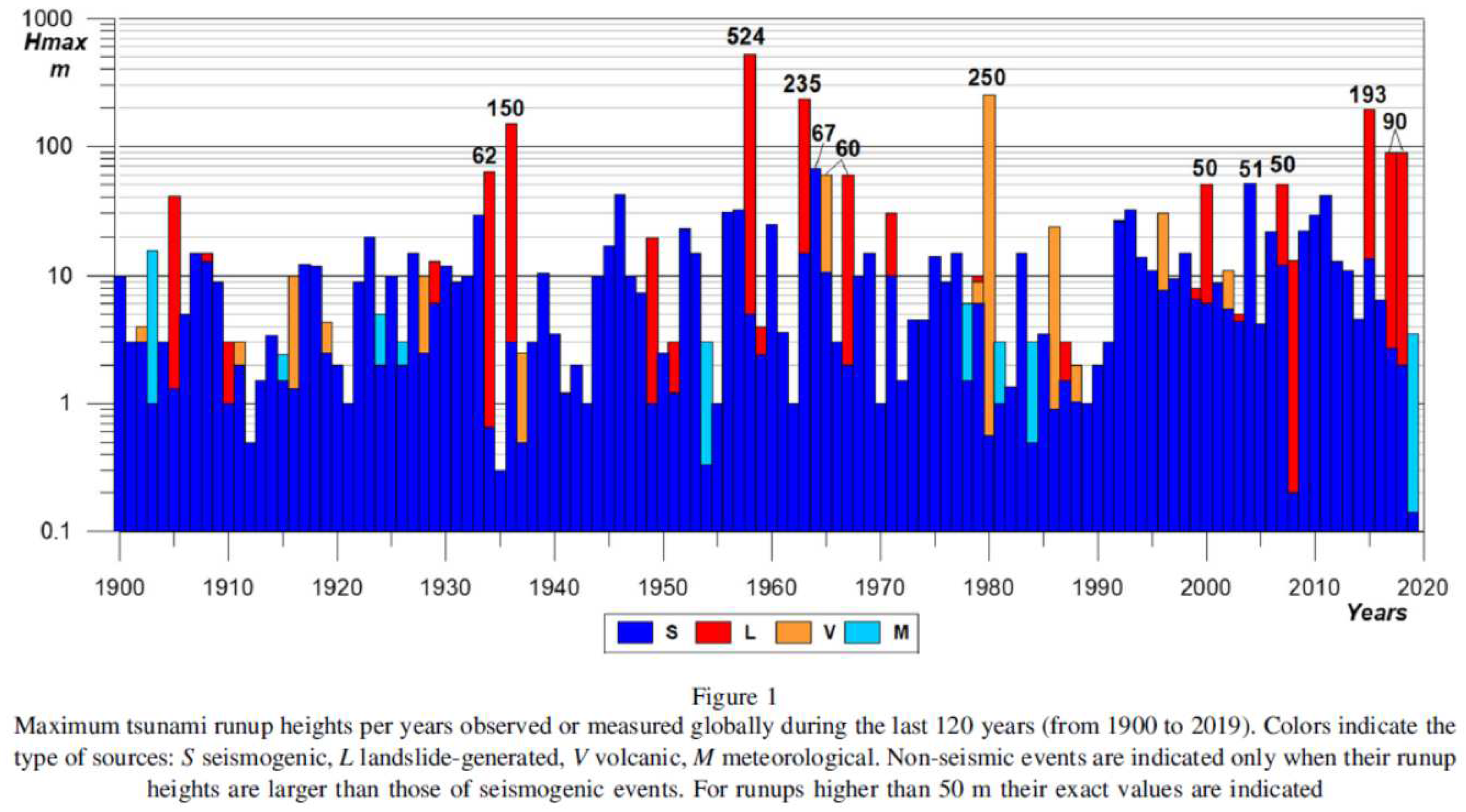
Figure 2.
Historical documented megatsunamis from the GHMCat.
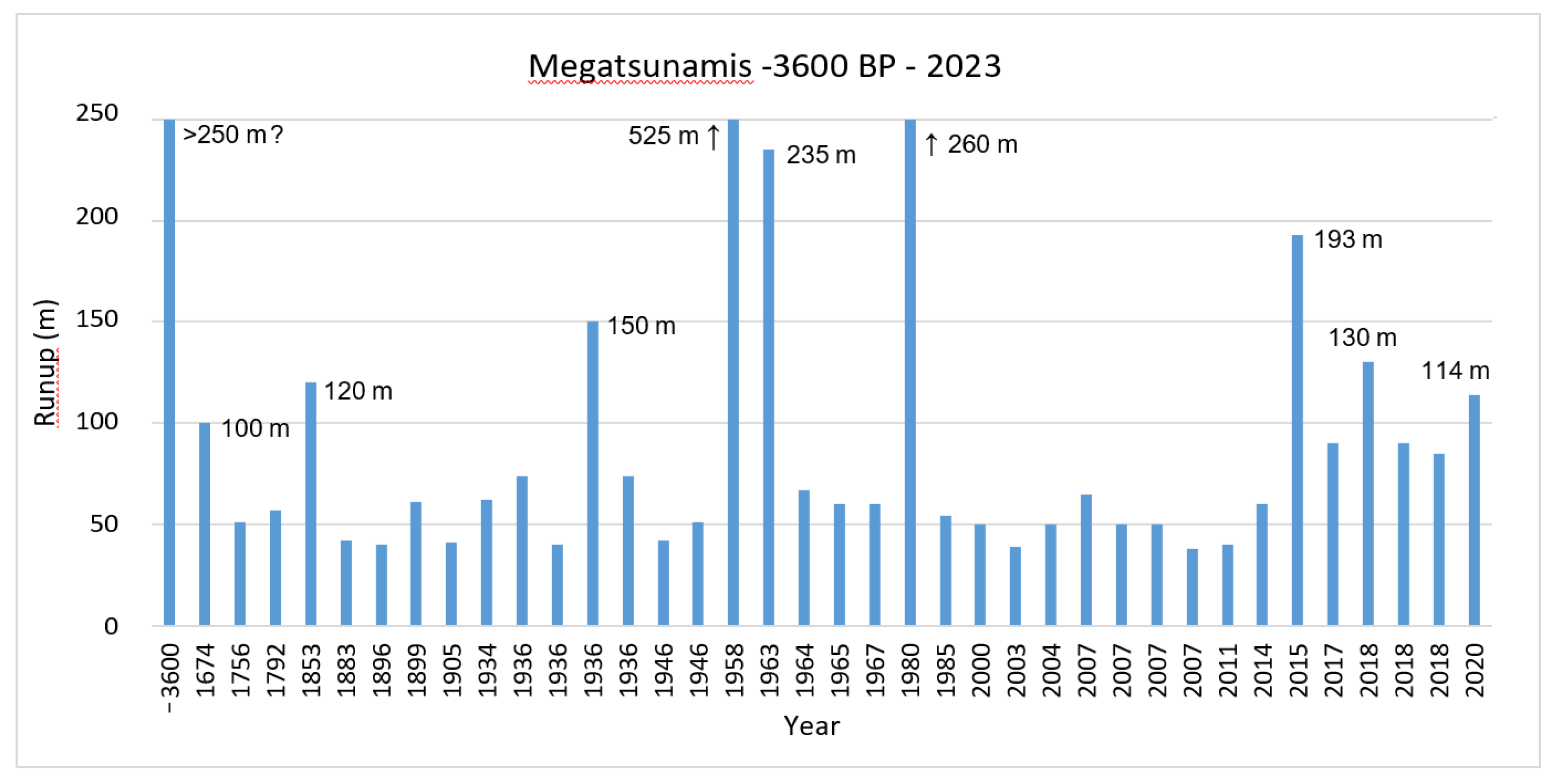
Figure 3.
The frigates l’Astrolabe and La Boussole anchored in July 1786 in Port des Français, now Lituya Bay. La Pérouse Expedition (https://fr.wikipedia.org/wiki/Baie_Lituya). The sharp trimlines left by the megatsunami waves can be clearly observed on the bay slopes, as well as a large rockslide in the background, indicating the recent occurrence of both events.
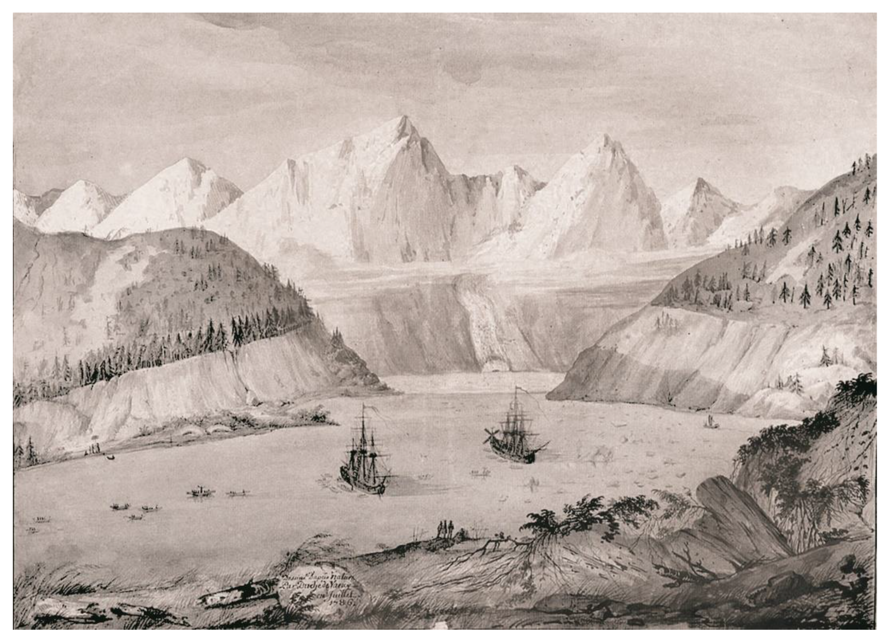

Table 1.
Historical megatsunamis with wave height (runup) ≥40 m from global databases NCEI/WDS [30] and TL/ICMMG [31] as of October 2023).
| Date | Name/Place | Cause* | Runup (m)* |
|---|---|---|---|
| 3600 BP Santorini, Greece | V / - | 90 / - | |
| 1674 | Ambon Island, Indonesia | LEq (6,8) / Eq (8) | 100 / 80 |
| 1737 | Kanchatka, Russia | Eq (8,5) | 15 / 63 |
| 1741 | Oshima Island, Japan | V / LV | 90 / 10 |
| 1771 | Ryukyu Islands, Japan | Eq (7,4) / LEq | 85,4 |
| 1788 | Sanak Island, Alaska | Eq (8) | 88 |
| 1792 | Kyushu Island, Japan | LV / V | 55 / 57 |
| 1853 | Lituya Bay, Alaska | L | 120 |
| 1880 | Sitka, Alaska | LEq (6,3) | 1,8 / 60 |
| 1883 | Krakatoa Island, Indonesia | V | 41 / 35 |
| 1899 | Lituya Bay, Alaska | LEq (8,2) | 61 |
| 1905 | Lovatnet Lake, Norway | L | 40 |
| 1934 | Tafjord, Norway | L | 62 |
| 1936 | Lovatnet Lake, Norway | L | 74 / 70 |
| 1936 | Lituya Bay, Alaska | L | 150 |
| 1946 | Unimak Island, Alaska | LEq (8,6) / Eq (8,6) | 42 |
| 1958 | Lituya Bay, Alaska | LEq (7,8) / L | 525 |
| 1963 | Vaiont Reservoir, Italy | L | 235 |
| 1964 | Port Valdez Bay, Alaska | LEq (9,2) / Eq (9,3) | 67 |
| 1965 | Cabrera Lake, Chile | LV / V | 60 |
| 1967 | Grewingk Glacier Lake, Alaska | L | 60 |
| 1980 | Spirit Lake, EE.UU. | V | 250 |
| 2000 | Vaigat Strait, Greenland | L | 50 |
| 2004 | Sumatra-Andaman, Indonesia | Eq (9,1) | 50,9 |
| 2007 | Aysén Fjord, Chile | LEq (6,2) / L | 50 / 65 |
| 2007 | Shuibuya Reservoir, China | L / - | 50 / - |
| 2011 | Sanriku, Japan | Eq (9,1) | ~56 / 42 |
| 2014 | Askja Lake, Island | L / - | 60 / - |
| 2015 | Taan Fjord, Alaska | L | 193 |
| 2017 | Karrat Fjord, Greenland | L | 90 |
| 2018 | Bureya Reservoir, Russia | L | 90 |
| 2018 | Anak Krakatau, Indonesia | LV / V | 85 |
| L: Landslide, rockslide or rock avalanche; LEq: Earthquake-triggered landslide, rockslide or rock avalanche; LV: Volcanic landslide; Eq: Earthquake (magnitude); V: Volcanic. | |||
| * Where the two global databases differ, data from both are given (NCEI/WDS / TL/ICMMG) | |||
Table 2.
Historical documented megatsunamis included in the GHMCat*.
| Date | Place/Name | Cause | Runup (m) | References |
|---|---|---|---|---|
| 3600 BP | Santorini Island, Greece | LV | 90; >250 ? | [45,46] |
| 1674 | Ambon Island, Indonesia | SLEq | 100 | [41,44] |
| 1756 | Langfjord, Norway | L | >50 | [59] |
| 1792 | Kyushu Island, Japan | LV | 57 | [61] |
| 1853 | Lituya Bay, Alaska | L | 120 m | [2] |
| 1883 | Krakatoa Island, Indonesia | LV ? | >40; >100 ? | [68] |
| 1896 | Sanriku, Japan | SLEq ? | ~40 | [70,71] |
| 1899 | Lituya Bay, Alaska | LEq | 61 | [2] |
| 1905 | Lovatnet Lake, Norway | L | 41 | [4,74] |
| 1934 | Tafjord, Norway | L | 62 | [74] |
| 1936 | Lovatnet Lake, Norway | L | 74 | [4,74] |
| 1936 | Lovatnet Lake, Norway | L | 40 | [4,75] |
| 1936 | Lituya Bay, Alaska | L | 150 | [2] |
| 1936 | Lovatnet Lake, Norway | L | >74 | [4] |
| 1946 | Unimak Island, Alaska | SLEq (8,6) | 42 | [76,77] |
| 1946 | Vancouver Island, Canada | LEq (7,3) | 51 | [82] |
| 1958 | Lituya Bay, Alaska | LEq (7,8) | 525 | [2,23] |
| 1963 | Vaiont Reservoir, Italy | L | 235 | [84,85] |
| 1964 | Port Valdez Bay, Alaska | SLEq (9,2) | 67 | [86] |
| 1965 | Cabrera Lake, Chile | L | 60 | [89] |
| 1967 | Grewingk Lake, Alaska | L? | 60 | [90] |
| 1980 | Spirit Lake, USA | LV | 260 | [30,92] |
| 1985 | Yangtze River, China | L | 54 | [93,94] |
| 2000 | Vaigat Strait, Greenland | L | 50 | [96] |
| 2003 | Three Gorges Reservoir, China | L | 39 | [97,98] |
| 2004 | Sumatra-Andaman, Indonesia | Eq (9,1); SLEq? | ~50 | [24,25] |
| 2007 | Aisen Fjord, Chile | LEq (6,2) | 65 | [101] |
| 2007 | Shuibuya Reservoir, China | L | 50 | [98] |
| 2007 | Grijalva River, Mexico | L | >50 | [102] |
| 2007 | Chehalis Lake, Canada | L | 38 | [103,104] |
| 2011 | Sanriku, Japan | SLEq (9,1) ? | ~40 | [71,72] |
| 2014 | Askja Lake, Iceland | L | >60 | [107] |
| 2015 | Taan Fjord, Alaska | L | 193 | [108] |
| 2017 | Karrat Fjord, Greenland | L | 90 | [109,110] |
| 2018 | Jinsha River, China | L | 130 | [111] |
| 2018 | Bureya Reservoir, Russia | L | 90 | [112] |
| 2018 | Anak Krakatau, Indonesia | LV | 85 | [113,114] |
| 2020 | Coast Mountains, Canada | L | 114 | [116] |
| * The megatsunami in Lituya Bay prior to 1876 is not included, as their age is unknown (see text for explanation) L – Landslide, rockslide or rock avalanche LEq - Earthquake-triggered subaerial landslide SLEq - Earthquake-triggered submarine landslide LV – Volcanic flank landslide Eq – Earthquake (magnitude) | ||||
Table 3.
New historical documented megatsunamis not included in the GHTDs.
| Date | Place/Name | Cause | Runup (m) | References | ||
|---|---|---|---|---|---|---|
| GHTDs | This study | GHTDs* | This study | |||
| 1756 | Langfjord, Norway | L | L | 38 / - | >50 | [59] |
| 1896 | Sanriku, Japan | SLEq ? | SLEq ? | 38.2 | 55 | [70,71] |
| 1936 | Lovatnet Lake, Norway | - | L | - | 40 | [4,75] |
| 1936 | Lovatnet Lake, Norway | - | L | - | >74 | [4] |
| 1946 | Vancouver Island, Canada | LEq (7.3) | LEq (7.3) | 9 / 30 | 51 | [82] |
| 1985 | Yangtze River, China | - | L | - | 54 | [93,94] |
| 2003 | Three Gorges Reservoir, China | - | L | - | 39(+) | [97,98] |
| 2007 | Grijalva River, Mexico | - | L | - | >50 | [102] |
| 2007 | Chehalis Lake, Canada | L | L | 38 | 38(+) | [103,104] |
| 2018 | Jinsha River, China | - | L | - | 130 | [111] |
| 2020 | Coast Mountains, Canada | - | L | - | 114 | [116] |
| L – Subaerial landslide or rock avalanche LEq - Earthquake-triggered subaerial landslide (magnitude) SLEq - Earthquake-triggered submarine landslide (magnitude) * Where the two GHTDs differ, data from both are given (NCEI/WDS / TL/ICMMG) (+) These are the only two documented tsunamis with runup >35 and <40 m (see text for explanation) | ||||||
Disclaimer/Publisher’s Note: The statements, opinions and data contained in all publications are solely those of the individual author(s) and contributor(s) and not of MDPI and/or the editor(s). MDPI and/or the editor(s) disclaim responsibility for any injury to people or property resulting from any ideas, methods, instructions or products referred to in the content. |
© 2023 by the authors. Licensee MDPI, Basel, Switzerland. This article is an open access article distributed under the terms and conditions of the Creative Commons Attribution (CC BY) license (http://creativecommons.org/licenses/by/4.0/).
Copyright: This open access article is published under a Creative Commons CC BY 4.0 license, which permit the free download, distribution, and reuse, provided that the author and preprint are cited in any reuse.


