
Submitted:
19 December 2023
Posted:
20 December 2023
You are already at the latest version
Abstract
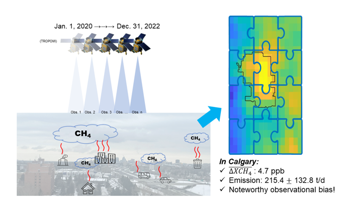
Cities are important sources of anthropogenic methane emissions. Municipal governments can play a role in reducing those emissions to support climate change mitigation, but they need information on the rate of emissions to context mitigation actions and track progress. Here, we examine the application of satellite data from the TROPOspheric Monitoring Instrument (TROPOMI) to estimate city-level methane emissions rates in a case study of the City of Calgary, Alberta, Canada. While satellites are touted as a global methane monitoring system, we found limited observational coverage over Calgary that precluded the reliability of measurement-based models to track the annual emissions. In this work, we integrated valid observations over three years (2020-22) and used mass balance modeling to derive a long-term averaged emission estimate. The column-averaged dry-air mole fraction (XCH4) enhancement over Calgary was small, 4.7 ppb, but within the city boundary, we identified local hot spots in the vicinity of known sources (wastewater treatment facility and landfills). The city-scale emissions estimate from mass balance was 215.4 ± 132.8 t/d CH4. This estimate is approximately four- and six-times larger than estimates from Canada's gridded national inventory report of anthropogenic CH4 emissions and the Emissions Database for Global Atmospheric Research (EDGAR v8.0), respectively. Valid observations are more common in warmer months and occur during a narrow daily overpass timeslot over Calgary – these effects may bias the emissions estimate. Overall, the findings from this case study highlight the challenge of deriving routine (sub-annual to annual) satellite-based estimates of city-scale methane emissions in similar geographic settings and suggest that more granular emissions inventories are needed to improve methane reporting.
Keywords:
methane
; TROPOMI
; mass balance
; emission estimate
; city-level
1. Introduction
Reduction of methane (CH4) emissions is considered an effective near-term pathway to reduce anthropogenic emissions that exacerbate climate change [1,2]. CH4 emissions from the energy (e.g., oil and gas production, coal mining), agriculture (rice cultivation, feedlots), and waste (landfills) sectors are three major sources of anthropogenic CH4 [3,4,5,6,7].
Urban areas, in particular, are a very poorly understood source of CH4 emissions due to the large diversity of sources. In urban areas wastewater treatment facilities and landfills are generally well known to be major emitters [8,9,10,11]. However, urban areas also contain many smaller, widely distributed sources such as leaks in natural gas (NG) distribution infrastructure, small scale agriculture, sewer emissions, natural gas vehicles, and slip from natural gas combustion [8,12,13,14,15,16]. Most of these sources are poorly understood and may vary considerably in emissions rate.
Due to the diversity and number of sources across urban areas, conventional bottom-up (BU) CH4 emissions inventories are normally inaccurate. There are considerable challenges associated with maintaining and implementing BU inventories in urban areas as inventories must model both the number of discrete emissions sources and predict appropriate emissions rates. Granular BU inventory models in urban environments will always carry considerable uncertainty. And by extension, inventory-based mitigation policy will be inherently inefficient as this uncertainty carries through to policy decisions.
To reduce the uncertainty of BU inventories, and understand if BU inventories are adequately simulating emissions, it is helpful to use larger-level top-down (TD) measurements. Measurements of atmospheric concentrations of CH4 in urban can be acquired with platforms such as ground-based stations and sensor networks, vehicle-based systems, aircraft-based systems, and satellites [e.g., 17,18,19,20,21,22,23]. The measurement resolution varies substantially from the facility level to the basin level depending on the platform. The TD approach uses these measurements and atmospheric transport modeling to estimate emissions rates and help understand the fidelity of BU estimates.
Among TD methods, satellites are of particular interest. The high observational density and large-scale geographic coverage of the TROPOspheric Monitoring Instrument (TROPOMI) on board the Copernicus Sentinel-5 Precursor satellite provides one of the best options for satellite TD measurements. Multiple approaches have been proposed and used to derive urban CH4 emissions based on TROPOMI observations, including transport inversion, two-dimensional Gaussian modeling, and tracer-tracer approaches [10,23,24,25]. Based on the methane measurements from a multitiered observing framework (including observations from TROPOMI, aircraft-based system, tow-based monitors, and ground-based stations), Cusworth et al. used geostatistical inverse modeling and the prior emissions to derive methane emissions from megacity areas [24]. De Foy et al. used a two-dimensional Gaussian model with TROPOMI observations and successfully derived methane emissions from 61 urban areas globally [10]. The tracer-tracer method, which quantifies emissions by scaling the ratios of prior estimates of CH4:CO or CH4:CO2 with atmospheric measurements has been used to derive CH4 emissions from urban centers in North America [23,25].
The majority of previous methods require significant data density. Calgary, located in a continental climate, has particularly low TROPOMI data density [26]. To work with the low data density over Calgary, we use the mass balance approach of Buchwitz et al. based on integrated observations [27]. This approach can be used as a tool to estimate regional CH4 emissions without resolving atmospheric transport. Here, we use TROPOMI data and the method of Buchwitz et al. to build preliminary top-down emissions flux estimates for the Calgary urban area. To obtain sufficient valid observations, we integrated all the valid observations during the 3-year period from 2020 and 2022. We explore the context of these measurements relative to existing inventories and existing estimates from other cities. We also examine how the characteristics of the TROPOMI satellite in high latitude observational settings could influence representative emissions estimates and consider possible corrections to build more accurate emissions measurements.
2. Materials and Methods
TROPOMI-based CH4 observation
The TROPOMI dataset used in this work includes 3-years of observations spanning 01 January 2020 to 31 December 2022. The spatial resolution of all the observations is 7 km × 5.5 km. The number of valid observations varies with regions due to impeding factors: cloud content, solar zenith angle, aerosol optical depth, topography, surface albedo, and surface roughness [26]. Only high-quality, bias-corrected XCH4, as indicated by a quality assurance qa_value > 0.5 (hereafter: valid observations), were used in our study. The Calgary overpass time of TROPOMI falls between 12:00 pm and 14:00 pm local time. The time-averaged XCH4 maps in 2020 and 2022 at 0.05° × 0.05° resolution were obtained from TROPOMI Level-2 data product using valid observations during the investigation period. Only grid cells with 10 or more valid observations were merged in the annual XCH4 map.
The data processing procedure is summarized in Figure 1. Since the original TROPOMI XCH4 data products are provided with a non-normalized grid, the first step was to develop a normalized 0.05° × 0.05° latitude-longitude grid for reallocation of multiple observations. For each individual observation, every valid XCH4 data point was reallocated onto the grid cell that corresponded with its geolocation. The screening of each individual observation was processed on basis of a self-developed TROPOMI daily screening toolkit [28]. After obtaining the re-gridded XCH4 observations, the time-averaged XCH4 maps for each region of interest were generated, accompanied by the coverage assessment. The generated XCH4 map was then denoised using Gaussian filters prior to the emission quantification. The filtering was completed using a 2-D Gaussian smoothing kernel with standard deviation of 1, and filter size of 3.
Emission quantification: mass balance model
We used a simplified flux model proposed by Buchwitz et al to derive the city-scale CH4 emissions [27]. The model uses mass balance theory to build an integrated emissions flux estimate from multiple TROPOMI data scenes. From the underlying theory, an air parcel with background XCH4 travels through the source region (characterized with the effective length, L, calculated as the square root of source region area) as directed by the wind (wind speed V). It is assumed that the XCH4 in the air parcel is enhanced as determined by the accumulation time τ (duration of the air parcel travelling through the source region, calculated as L/V) and the emission rate (Q) in the source region. As follows, the CH4 column mass enhancement (ΔmCH4, CH4 mass per area) is calculated as Q/L^2×τ. It is also assumed that when travelling through the source region, ΔmCH4 increases linearly. Therefore, the average column mass enhancement over the source region can be calculated as 0.5×ΔmCH4, where ΔmCH4 is calculated from the observed XCH4 via introducing a factor M with the unit of mass per area and ppb. As a result, the modeled column mass enhancement and the observation-based column mass enhancement are connected. The basic equation for this method is following:
where the ΔXCH4 in equation (1) is the CH4 enhancement in ppb, derived from the valid TROPOMI observations; M is the factor to convert the atmospheric total column mixing ratio to mass, which is 5.345 kg CH4/km2/ppb; L (km) is the effective length of the source region. V (km/d) is the ventilation wind speed derived from the in-situ measurements at multiple air monitoring stations in Calgary urban area; C is a unitless factor of 2.0, which is the assumed linear increase in CH4 column mass enhancement of the air parcel when travelling over the source region [27]; Mexp is a dimensionless factor to correct for the actual mass, calculated using the following equation:
where pi is the surface pressure of the ith grid cell, which is obtained from the instantaneous 3-dimensional monthly mean data collection in MERRA-2.
Background XCH4 is required to calculate ΔXCH4 over the region of interest. Background XCH4 can be estimated using XCH4 upwind of the study region or a statistical approach [29]. The number of valid upwind observations may be insufficient to provide a robust estimate of background XCH4 given impeding factors such as cloud cover, surface albedo, and aerosol optical depth [26]. Similarly, given that background XCH4 is non-homogenous in large study regions, background estimates derived with the statistical approach can be biased. Previous research that detected global ultra-emitter (≥ 25 tonnes/hr) plumes improved background estimates in noisy remotely-sensed imagery [29]. The computation of the background value is sensitive to the skewness of the XCH4 values, which is indicated by the value of (XCH4,mean- XCH4,median)/ XCH4,std. Thus, as indicated by equation 4, for regions with highly skewed XCH4, the background is computed as the median. Otherwise, the background is computed as l x median – (l-1) x mean. The pixel specific ΔXCH4 is derived by subtracting background XCH4 from XCH4 for each pixel in the study region. Pixels with ΔXCH4 less than XCH4,std were not considered as source pixels and therefore were not included in the calculation of regional ΔXCH4. This was done to exclude pixels with ΔXCH4 biased by the regional variation of XCH4.
The uncertainty of the estimate (σ) is computed as the combined uncertainty of the calculations of CH4 enhancement ΔXCH4 () and the conversion factor CF (), as indicated by equation 5. The is calculated as the standard deviation over the source pixels in the study region (i.e., XCH4,std). The main contributor to σCF is uncertainty in wind speed. In this work, is assumed equivalent to , and is estimated from the variation in wind speed during averaging.
3. Results
3.1. Observational coverage
We first examined the annual coverage in each year. However, the availability of valid observations over Calgary and the surrounding area varies significantly year by year. The average number of valid observations (NVO) for all pixels within Calgary was: 2020 (NVO = 7), 2021 (NVO = 16), and 2022 (NVO = 17). Based on the limited observations for each year, it is hard to obtain a full picture of XCH4 in Calgary and surrounding areas on a year-to-year basis. Year to year XCH4 observation from years with limited NVO have large potential of being severely influenced by specific meteorological situations, which can affect the validity of the flux model [27].
Aggregation of the valid observations during multiple years provides a solution to obtain time-averaged emissions. After integrating all the valid observations from 2020 to 2022, the average NVO in Calgary was 45, which is sufficient to average various CH4 emitting and meteorological conditions. The total NVO during the 3-year period is shown in Figure 2a. Also implied by Figure 2c, nearly all the pixels in Calgary and the surrounding areas approached the predefined minimum NVO of 10. The areas with less valid observations (to the Southeast and East side of Calgary) are characterized by the transition areas of flat prairie to mountainous region. This is consistent with prefiltering rules in the retrieval algorithm of TROPOMI data products (i.e., pixels with high surface roughness will not be processed for XCH4 retrieval).
3.2. Methane enhancements
Figure 2b,c show XCH4 over the Calgary urban and surrounding areas between 01 January 2020 and 31 December 2022. The XCH4 within the city boundary is higher than the surrounding area. Higher XCH4 areas were found in central and northeast Calgary. The observed mean XCH4 in Calgary is 1879.1 ± 2.7 ppb, while the mean and median XCH4 within the broader area (dashed black line) are 1873.3 ppb and 1874.5.6 ppb. The background XCH4 was estimated at 1876.3 ppb. It should be noted that not all the pixels within the city boundary of Calgary were found to have elevated XCH4. Therefore, the calculated mean XCH4 for the entire urban region of Calgary does not exhibit substantially higher XCH4 compared to the background XCH4.
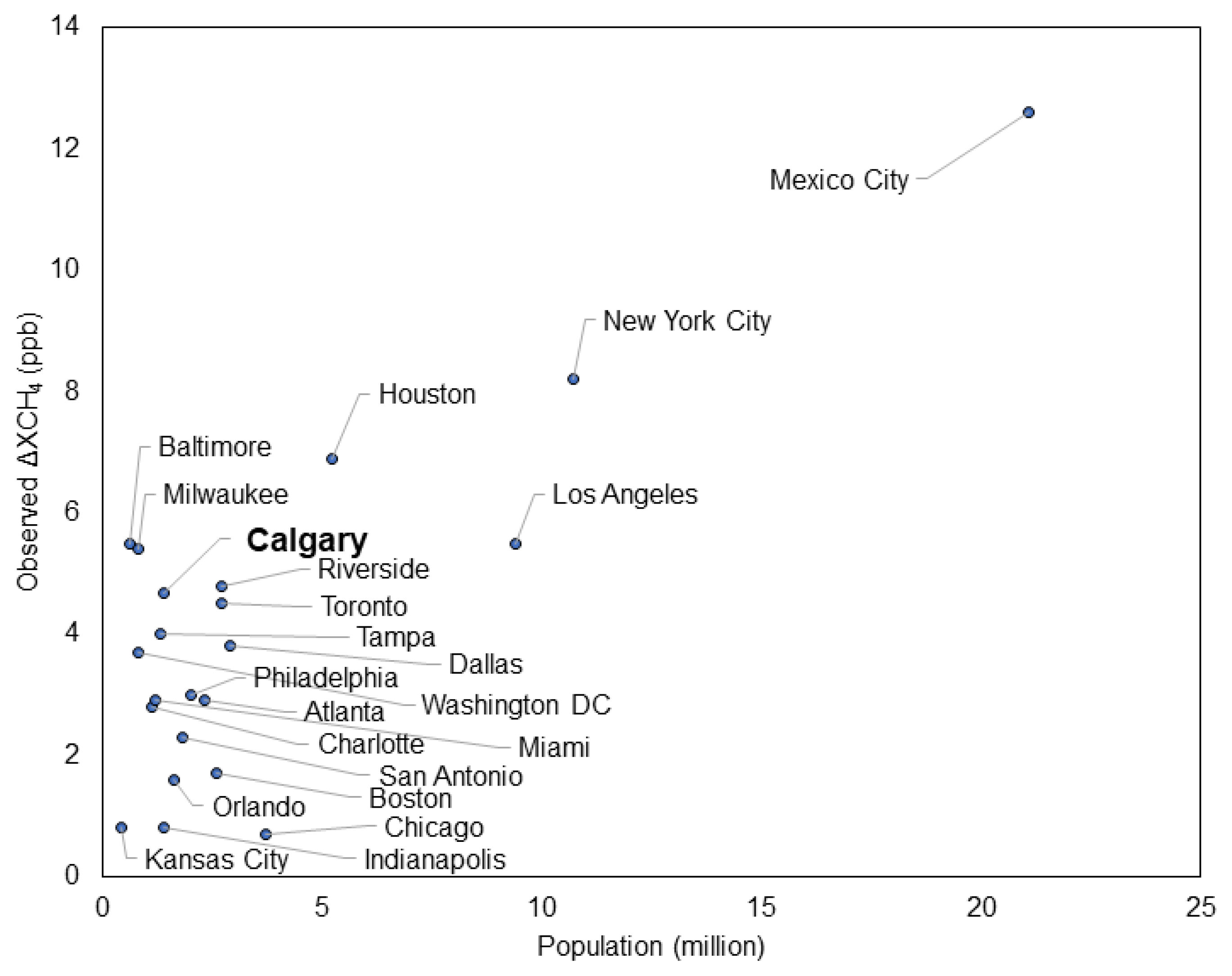
Pixel-specific enhancements, ΔXCH4, were derived by subtracting the background from the observed XCH4 (Figure 2d). Only the pixels with enhancements greater than the standard deviation (2.7 ppb) were defined as ‘sources’ within the study area. The mean ΔXCH4 caused by the ‘sources’ was calculated as 4.7 ppb. Compared to the TROPOMI-based ΔXCH4 from other hotspot urban areas in North America [23], the ΔXCH4 in Calgary is located near the upper end of city-level enhancements derived from the similarly populated cities (< 5 million). The most elevated enhancement (7.4 ppb) was found in central Calgary. There are 22 facilities in Calgary that are required to report annual CH4 emissions to Canada’s Greenhouse Gas Reporting Program (GHGRP). As indicated in Figure 2d, nearly all the facilities (21/22) were located within the XCH4 enhanced areas as determined in our analysis.
Figure 3.
The TROPOMI-based city-level ΔXCH4 of multiple cities in North America. Data for all cities but Calgary were derived from the work conducted by Plant et al. [23].
Figure 3.
The TROPOMI-based city-level ΔXCH4 of multiple cities in North America. Data for all cities but Calgary were derived from the work conducted by Plant et al. [23].
3.3. Methane flux and comparisons with BU inventories
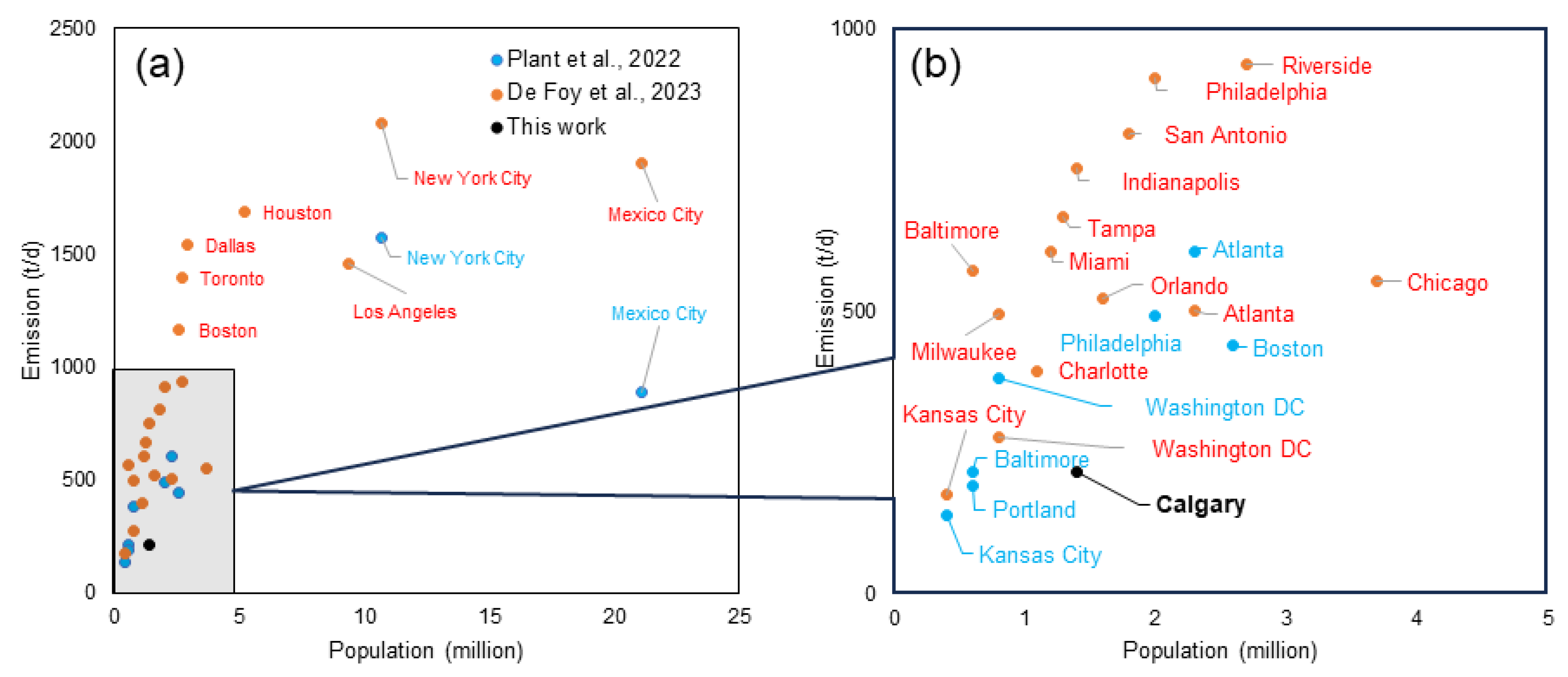
Using the mass balanced method, we calculated the CH4 emissions rate in Calgary as 215.4±132.8 t/d. Compared to recent aerial- and TROPOMI-based CH4 emission estimates from other North American cities in the literature [10,23,25], Calgary’s annual emissions are on relatively low (Figure 4), but comparable with cities that have slightly lower and higher emissions and populations, respectively(e.g., Milwaukee, Charlotte, Kansas City, Washington DC, Baltimore).
In comparison, city-level CH4 emissions from BU emission inventories showed much lower estimates than our measurement-based estimate. The most recent EDGAR inventory (i.e., v8.0) provide estimates of city-level CH4 emissions for Calgary at 31.6 t/d (2020), 38.2 t/d (2021), and 34.9 t/d (2022). Canada's gridded national inventory report (NIR) of anthropogenic CH4 emissions estimates a rate of 48.3 t/d for Calgary in 2018 [30]. This is notably higher than the EDGAR estimates, but still only accounts for less than one quarter of the measurement-based estimate.
In Canada, the Greenhouse Gas Reporting Program (GHGRP) collects information on greenhouse gas (GHG) emissions annually from facilities across Canada. As a mandatory program, facilities that emit 10 kilotonnes or more of GHGs, in carbon dioxide equivalent (CO2e) units, per year must report their emissions to the Canadian federal regulator Environment and Climate Change Canada [31]. We find that 22 facilities reporting to GHGRP within Calgary’s city limits averaged a total of 16.5 t/d of CH4 emissions between 2020 and 2021, which only accounts for a very limited amount of emissions of the measurement-based emissions.

Table 1.
City-scale CH4 emissions rate in Calgary.
| Data source | Emissions rate (t/d) | Year |
|---|---|---|
| EDGARv8 | 31.6 | 2020 |
| EDGARv8 | 38.2 | 2021 |
| EDGARv8 | 34.9 | 2022 |
| EDGARv8 | 34.9 | 2020-2022 |
| Gridded NIR | 48.3 | 2018 |
| GHGRP1 | 16.5 | 2020-2021 |
| This work | 215.4±132.8 | 2020-2022 |
1 Only include the sources that annual emissions are > 10 kt in CO2e.
Figure 4.
City-level methane emissions from North American cities. All the city-level emissions were estimated with TROPOMI observations, but used different quantification approaches. Data except Calgary were adapted from Plant et al. [23] and De Foy et al. [10]. Population data for Calgary were obtained from the Government of Alberta open data [32].
3.4. Observational bias
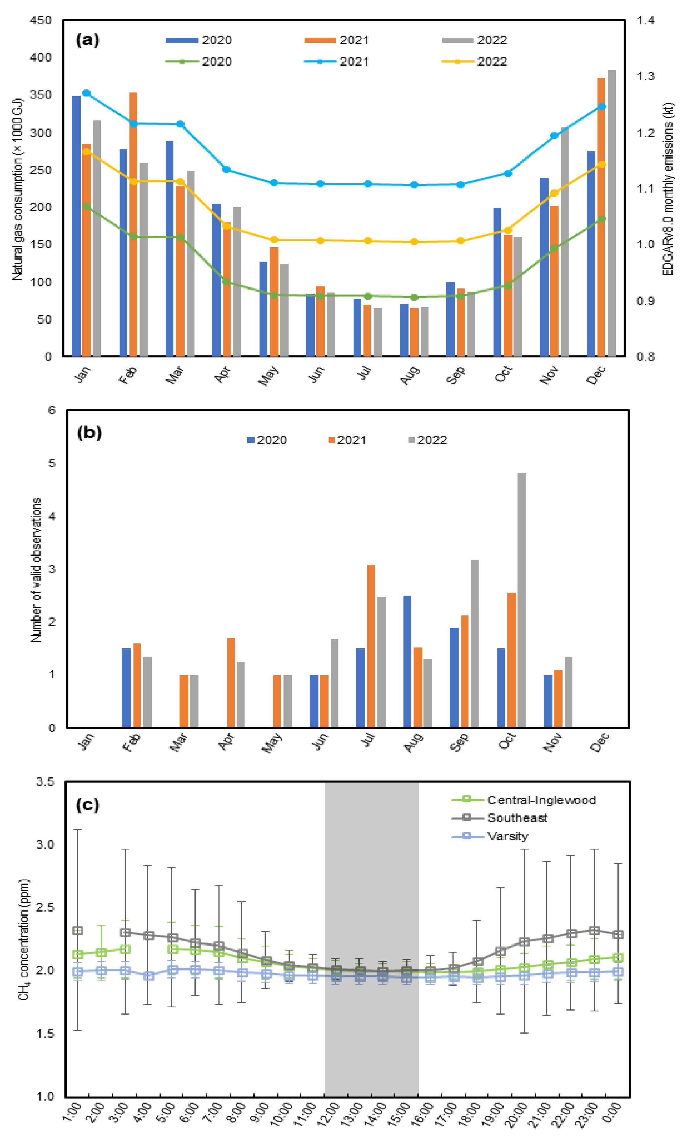
As suggested by EDGARv8.0, there is modest seasonal variation to Calgary’s CH4 emissions, with slightly lower emissions in the summer than the winter (Figure 5a). This is consistent with measurement-based estimate from the Baltimore and Washington, D.C. metropolitan Region [33]. Urban CH4 sources (e.g., natural gas end-use combustion for heating, landfills, and wastewater treatment), are characterized by noteworthy temporal variations related natural gas consumption, barometric pressure, temperature, and moisture [34,35,36,37]. It is possible that different emissions processes compete and dominate the city-level emissions profile at different times of the year. However, from the 3-year analysis, the valid observations in Calgary from TROPOMI were mainly distributed in the period from June to October in each year, as indicated in Figure 5b.
As a supplemental indicator, the monthly natural gas consumption of City of Calgary facilities was included in Figure 5a to examine potential seasonality and temperature-induced fluctuation of CH4 emissions related to natural gas end-use. We use the EDGARv8.0 emissions variability to seasonally-correct our Calgary estimate from 215.4 t/d to 220.1 t/d. Compared to the large uncertainty surrounding our mean estimate, this correction has little impact on the magnitude of the city-level emission rate. The limitation of using the seasonality from EDGAR to temporally-correct our estimate is that inventories have known issues with under-estimating CH4 emissions compared to measurement-based estimates. Therefore, it is challenging to draw more definitive conclusions on annual emissions using TROPOMI data because the observations are temporally constrained.
Another noteworthy point of using TROPOMI observations is the fixed sensing time slot on each day for Calgary. TROPOMI’s overpass time slot for Calgary is between 12:00 - 15:00 local time. For sources with strong diurnal variations, the fixed observation time may result in marked uncertainty when scaling up emissions from an hourly to a daily/monthly/annual rate. Measurement-based emission estimates conducted in London, U.K. show the highest emission flux around 12:00pm with a maximum-to-minimum ratio of 1.9 [38]. Figure 5c shows the hourly variations of the CH4 concentrations from three ground-based air monitoring stations in Calgary. The data show that CH4 concentrations are relatively lower during the TROPOMI overpass time slot. Furthermore, the TROPOMI overpass time for Calgary spans typical work hours during the week. CH4 emissions measurements from a sensor mounted on a light-rail transit platform in Salt Lake Valley, Utah found temporal variations in emissions from a manufacturing facility [39]. Plumes from this facility were only detectable during work hours. Similar sources of emissions likely exist in Calgary. This introduces more uncertainty into scaling the hourly emissions rate up to an annual rate, as emissions patterns from different sources may fluctuate between days/evenings, weekdays/weekends, and holidays.
Figure 5.
Temporal variations of emissions and sources in the City of Calgary: (a) monthly natural gas consumption data for City of Calgary facilities (bar) and BU inventory estimates from EDGAR v8.0 (line), (b) monthly frequency of valid TROPOMI observations, and (c) average ground-based CH4 concentration measurements from three air monitoring stations for the months from June to October in 2020, 2021, and 2022. Natural gas consumption data were obtained from the City of Calgary open data [40]. Continuous hourly ground-level CH4 concentration measurements were retrieved from the Calgary Region Airshed Zone website [41]. Shaded time slot in (c) was the TROPOMI overpass time for Calgary.
4. Discussion and conclusions
Our results suggest that TROPOMI cannot currently be used to track Calgary’s annual CH4 emissions because the number of valid observations is insufficient. We assume the limited observational coverage in 2020, 2021, and 2022 is representative of conditions in future years. The number of valid TROPOMI observations for Calgary varied year-by-year. This constrains the suite of approaches that can be used to quantify emissions rates with these data. Other cities with similar constrants on TROPOMI observational coverage are likely to encounter similar limitations and encounter a relatively coarse temporal lense using TROPOMI and similarly constrained satellite data to monitor CH4 emissions.
Despite these challenges, our study shows that the method of Buchwitz et al. can be applied using several years of TROPOMI data to derive a long-term time-averaged city-level urban CH4 emissions. This addresses issues with an insufficient number of valid annual observations for higher-latitude cities like Calgary where TROPOMI coverage is limited. The 3-year averaged CH4 emission rate in Calgary was estimated at 215.4 t/d. This estimate falls in the lower end of other measurement-based CH4 emissions estimated in other North American cities, and is comparable with the magnitude of emission in cities with similarly populations.
Comparisons with widely used global inventories of CH4 emissions suggest that inventories are under-estimating CH4 emissions from the Calgary urban area. The mismatch between the BU emissions inventory and the measurement-based estimate from this study is consistent with the conclusions derived from investigations conducted in other urban areas in North America [10,23,25,42]. There is evidence that urban emissions in general (and Calgary specifically) are higher than initially predicted, but the exact source of the discrepancy cannot be reliably determined from these data.
The time-averaged emission estimate using the simplified mass balance method is relatively robust to poor satellite coverage – but is well acknowledged to be less accurate than more complex methods because of the simplified transport algorithm. Buchwitz et al. provide an extensive discussion of the uncertainties inherent in the method and it must be stressed that estimate for Calgary carries considerable uncertainty [27]. The observational bias discussed in this work likely introduces additional uncertainties in the emissions estimate. Further work will assess whether more complex models can be used to estimate CH4 emissions in Calgary with TROPOMI data due to the poor satellite coverage.
Outside of the emissions rate quantification, Calgary has a clear CH4 enhancement relative to the surrounding region. This indicates that Calgary is a CH4 emissions hotspot. This result is significant in the context of upstream oil and gas production to the east of Calgary that likely contributes to elevated background XCH4 in the region. There is also some spatial variability in the enhancement across the city that warrants further investigation.
TROPOMI measurements are biased to warmer months in Calgary. This raises a potential for observational bias. However, seasonal variability from inventories is relatively small, suggesting that although it is possible to correct for this observational bias, the impact is quite small compared to the major issues associated with inventory- measurement mismatch. This noted, it is vital to note that these results suggest that inventories may not be accurately modeling emissions across Calgary – and by extension, suggests that the mechanics of urban CH4 emissions in Calgary may not be represented accurately. There may be more (or less) seasonal variability than modeled by EDGARv8.0 and seasonal bias corrections based on EDGARv8.0 are inherently compromised.
Despite the uncertainty in the method, the results do justify more work to better understand the emissions profile of Calgary (and by extension, similar urban areas). Results suggest that inventories are likely not capturing the true emissions profile, and a combination of measurements at different scales, with different measurement techniques, and detailed inventory work will be necessary to unpack and bring new accuracy to urban CH4 emissions profiles. This work will, in turn, guide abatement policy and ensure that public policy is constructed and applied in the most efficient manner possible – focusing on the most important and abatable CH4 sources and creating real and verifiable progress in emissions reductions.
Author Contributions
Conceptualization, Z.X., C.V., T.E.B., and C.H.; Methodology, Z.X. and M.G; Data Curation and Formal Analysis, Z.X.; Writing – Original Draft Preparation, Z.X., and T.E.B.; Writing – Review & Editing, Z.X., C.V., T.E.B., M.G., and C.H.; Visualization, Z.X. and M.G.; Supervision, C.H..; Project Administration, C.H.; Funding Acquisition, C.H.
Funding
This research was funded by Government of Canada via the Calgary Urban Methane Emissions Measurement Testbed (CURMET) project.
Data Availability Statement
Datasets used in this work are public accessible as follows: The TROPOMI L2 methane observations data products are available at: https://disc.gsfc.nasa.gov/datasets/S5P_L2__CH4____HiR_2/summary?keywords=Sentinel-5P%20TROPOMI; The Modern-Era Retrospective analysis for Research and Applications version 2 (MERRA-2) datasets are available at: https://disc.gsfc.nasa.gov/datasets/M2IMNPASM_5.12.4/summary?keywords=wind; The EDGARv8.0 GHG emissions datasets are available at: https://edgar.jrc.ec.europa.eu/dataset_ghg80; The ground-based stationary continuous minitoring data of methane in Calgary are available at: https://data-donnees.az.ec.gc.ca/data/air/monitor/national-air-pollution-surveillance-naps-program/Data-Donnees/?lang=en; and the natural gas consumption data of City of Calgary facilities are available at: https://data.calgary.ca/Environment/Primary-Natural-Gas-Usage/s5g9-8sgf. The TROPOMI data processing toolkit is available at: https://github.com/MozhouGao/TROPOMI_Daily_Screening_Toolkit.git.
Acknowledgments
This research was undertaken as part of the Calgary Urban Methane Emissions Measurement Testbed (CURMET) project with financial support from the Government of Canada. The authors thank EDGAR team for the public accessible Global Greenhouse Gas emissions database (EDGARv8.0 products); TROPOMI team for the public accessible TROPOMI L2 data products; and NASA Goddard Earth Sciences (GES) Data and Information Services Center (DISC) for providing the easily accessible data platform.
Conflicts of Interest
The authors declare no conflict of interest.
References
- Shoemaker, J.K.; Schrag, D.P.; Molina, M.J.; Ramanathan, V. What role for short-lived climate pollutants in mitigation policy? Science, 2013, 342(6164), 1323–1324. [Google Scholar] [CrossRef]
- Nisbet, E.G.; Manning, M.R.; Dlugokencky, E.J.; Fisher, R.E.; Lowry, D.; Michel, S.E.; Myhre, C.L.; Platt, S.M.; Allen, G.; Bousquet, P.; Brownlow, R. Very strong atmospheric CH4 growth in the 4 years 2014–2017: Implications for the Paris Agreement. Global Biogeochem. Cy., 2019, 33(3), 318–342. [Google Scholar] [CrossRef]
- Yusuf, R.O.; Noor, Z.Z.; Abba, A.H.; Hassan, M.A.A.; Din, M.F.M. CH4 emission by sectors: a comprehensive review of emission sources and mitigation methods. Renew. Sustainable Energy Reviews 2012, 16 (7), 5059–5070. [Google Scholar] [CrossRef]
- Zhang, Y.; Gautam, R.; Pandey, S.; Omara, M.; Maasakkers, J.D.; Sadavarte, P.; Lyon, D.; Nesser, H.; Sulprizio, M.P.; Varon, D.J.; Zhang, R.; Houweling, S.; Zavala-Araiza, D.; Alvarez, R.A.; Lorente, A.; Hamburg, S.P.; Aben, I.; Jacob, D. Quantifying CH4 emissions from the largest oil-producing basin in the United States from space. Sci. Adv. 2020, 6(17), 5120. [Google Scholar] [CrossRef] [PubMed]
- Kholod, N.; Evans, M.; Pilcher, R.C.; Roshchanka, V.; Ruiz, F.; Coté, M.; Collings, R. Global CH4 emissions from coal mining to continue growing even with declining coal production. J. Clean. Prod., 2020, 256, 120489. [Google Scholar] [CrossRef] [PubMed]
- Jiang, Y.; Qian, H.; Huang, S.; Zhang, X.; Wang, L.; Zhang, L.; Shen, M.; Xiao, X.; Chen, F.; Zhang, H.; Lu, C. Acclimation of CH4 emissions from rice paddy fields to straw addition. Sci. Adv. 2019, 5(1), 9038. [Google Scholar] [CrossRef] [PubMed]
- Maasakkers, J.D.; Varon, D.J.; Elfarsdóttir, A.; McKeever, J.; Jervis, D.; Mahapatra, G.; Pandey, S.; Lorente, A.; Borsdorff, T.; Foorthuis, L.R.; Schuit, B.J. Using satellites to uncover large CH4 emissions from landfills. Sci. Adv. 2022, 8(31), 9683. [Google Scholar] [CrossRef]
- Cambaliza, M.O.; Shepson, P.B.; Bogner, J.E.A.N.; Caulton, D.R.; Stirm, B.; Sweeney, C.; Montzka, S.A.; Gurney, K.R.; Spokas, K.; Salmon, O.E.; Lavoie, T.N. Quantification and source apportionment of the methane emission flux from the city of Indianapolis. Elementa, 2015, 3, 000037. [Google Scholar] [CrossRef]
- Ars, S.; Vogel, F.; Arrowsmith, C.; Heerah, S.; Knuckey, E.; Lavoie, J.; Lee, C.; Pak, N.M.; Phillips, J.L.; Wunch, D. Investigation of the spatial distribution of methane sources in the greater Toronto area using mobile gas monitoring systems. Environ. Sci. Technol. 2020, 54(24), 15671–15679. [Google Scholar] [CrossRef]
- De Foy, B.; Schauer, J.J.; Lorente, A.; Borsdorff, T. Investigating high methane emissions from urban areas detected by TROPOMI and their association with untreated wastewater. Environ. Res. Lett. 2023, 18(4), 044004. [Google Scholar] [CrossRef]
- Nesser, H.; Jacob, D.J.; Maasakkers, J.D.; Lorente, A.; Chen, Z.; Lu, X.; Shen, L.; Qu, Z.; Sulprizio, M.P.; Winter, M.; Ma, S. High-resolution US methane emissions inferred from an inversion of 2019 TROPOMI satellite data: contributions from individual states, urban areas, and landfills. EGUsphere, 2023, pp.1-36. [CrossRef]
- Cui, Y.Y.; Brioude, J.; McKeen, S.A.; Angevine, W.M.; Kim, S.W.; Frost, G.J.; Ahmadov, R.; Peischl, J.; Bousserez, N.; Liu, Z.; Ryerson, T.B. Top-down estimate of methane emissions in California using a mesoscale inverse modeling technique: The South Coast Air Basin. J. Geophys. Res. Atmos. 2015, 120 (13), 6698–6711. [Google Scholar] [CrossRef]
- Chamberlain, S.D.; Ingraffea, A.R.; Sparks, J.P. Sourcing methane and carbon dioxide emissions from a small city: Influence of natural gas leakage and combustion. Environ. Pollut. 2016, 218, 102–110. [Google Scholar] [CrossRef] [PubMed]
- Hopkins, F.M.; Kort, E.A.; Bush, S.E.; Ehleringer, J.R.; Lai, C.T.; Blake, D.R.; Randerson, J.T. Spatial patterns and source attribution of urban CH4 in the Los Angeles Basin. J. Geophys. Res. Atmos. 2016, 121(5), 2490–2507. [Google Scholar] [CrossRef]
- Fischer, M.L.; Chan, W.R.; Delp, W.; Jeong, S.; Rapp, V.; Zhu, Z. An estimate of natural gas methane emissions from California homes. Environ. Sci. Technol. 2018, 52(17), 10205–10213. [Google Scholar] [CrossRef] [PubMed]
- Hajny, K.D.; Salmon, O.E.; Rudek, J.; Lyon, D.R.; Stuff, A.A.; Stirm, B.H.; Kaeser, R.; Floerchinger, C.R.; Conley, S.; Smith, M.L.; Shepson, P.B. Observations of methane emissions from natural gas-fired power plants. Environ. Sci. Technol. 2019, 53(15), 8976–8984. [Google Scholar] [CrossRef] [PubMed]
- Hopkins, F.M.; Ehleringer, J.R.; Bush, S.E.; Duren, R.M.; Miller, C.E.; Lai, C.T.; Hsu, Y.K.; Carranza, V.; Randerson, J.T. Mitigation of CH4 emissions in cities: How new measurements and partnerships can contribute to emissions reduction strategies. Earth's Future 2016, 4(9), 408–425. [Google Scholar] [CrossRef]
- Ren, X.; Salmon, O.E.; Hansford, J.R.; Ahn, D.; Hall, D.; Benish, S.E.; Stratton, P.R.; He, H.; Sahu, S.; Grimes, C.; Heimburger, A.M.; Martin, C.R.; Cohen, M.D.; Stunder, B.; Salawitch, R.J.; Ehrman, S.H.; Shepson, P.B.; Dickerson, R.R. CH4 emissions from the Baltimore-Washington area based on airborne observations: Comparison to emissions inventories. J. Geophys. Res. Atmos. 2018, 123(16), 8869–8882. [Google Scholar] [CrossRef]
- Goldsmith Jr, C.D.; Chanton, J.; Abichou, T.; Swan, N.; Green, R.; Hater, G. Methane emissions from 20 landfills across the United States using vertical radial plume mapping. J. Air Waste Manage 2012, 62(2), 183–197. [Google Scholar] [CrossRef]
- Okorn, K.; Jimenez, A.; Collier-Oxandale, A.; Johnston, J.; Hannigan, M. Characterizing methane and total non-methane hydrocarbon levels in Los Angeles communities with oil and gas facilities using air quality monitors. Sci. Total Environ. 2021, 777, 146194. [Google Scholar] [CrossRef]
- Ryoo, J.M.; Iraci, L.T.; Tanaka, T.; Marrero, J.E.; Yates, E.L.; Fung, I.; Michalak, A.M.; Tadić, J.; Gore, W.; Bui, T.P.; Dean-Day, J.M. Quantification of CO2 and CH4 emissions over Sacramento, California, based on divergence theorem using aircraft measurements. Atmos. Meas. Tech. 2019, 12(5), 2949–2966. [Google Scholar] [CrossRef]
- Miller, S.M.; Wofsy, S.C.; Michalak, A.M.; Kort, E.A.; Andrews, A.E.; Biraud, S.C.; Dlugokencky, E.J.; Eluszkiewicz, J.; Fischer, M.L.; Janssens-Maenhout, G.; Miller, B.R. Anthropogenic emissions of CH4 in the United States. P. Natil. Acad. Sci. 2013, 110(50), 20018–20022. [Google Scholar] [CrossRef] [PubMed]
- Plant, G.; Kort, E.A.; Murray, L.T.; Maasakkers, J.D.; Aben, I. Evaluating urban CH4 emissions from space using TROPOMI CH4 and carbon monoxide observations. Remote Sens. Environ., 2022, 268, 112756. [Google Scholar] [CrossRef]
- Cusworth, D.H.; Duren, R.M.; Yadav, V.; Thorpe, A.K.; Verhulst, K.; Sander, S.; Hopkins, F.; Rafiq, T.; Miller, C.E. Synthesis of methane observations across scales: strategies for deploying a multitiered observing network. Geophys. Res. Lett. 2020, 47(7), 2020GL087869. [Google Scholar] [CrossRef]
- Plant, G.; Kort, E.A.; Floerchinger, C.; Gvakharia, A.; Vimont, I.; Sweeney, C. Large fugitive CH4 emissions from urban centers along the US East Coast. Geophys. Res. Lett. 2019, 46(14), 8500–8507. [Google Scholar] [CrossRef] [PubMed]
- Gao, M.; Xing, Z.; Vollrath, C.; Hugenholtz, C.H.; Barchyn, T.E. Global observational coverage of onshore oil and gas CH4 sources with TROPOMI. Sci. Rep. 2023, 13(1), 16759. [Google Scholar] [CrossRef] [PubMed]
- Buchwitz, M.; Schneising, O.; Reuter, M.; Heymann, J.; Krautwurst, S.; Bovensmann, H.; Burrows, J.P.; Boesch, H.; Parker, R.J.; Somkuti, P.; Detmers, R.G.; Hasekamp, O.P.; Aben, I.; Bulz, A.; Frankenberg, C.; Turner, A.J. Satellite-derived CH4 hotspot emission estimates using a fast data-driven method. Atmos. Chem. Phys. 2017, 17(9), 5751–5774. [Google Scholar] [CrossRef]
- Gao, M.; Xing, Z.; TROPOMI Daily Screening Toolkit - Version 1.0 Available online: https://github.com/MozhouGao/TROPOMI_Daily_Screening_Toolkit.git.
- Lauvaux, T.; Giron, C.; Mazzolini, M.; d’Aspremont, A.; Duren, R.; Cusworth, D.; Shindell, D.; Ciais, P. Global assessment of oil and gas CH4 ultra-emitters. Science 2022, 375(6580), 557–561. [Google Scholar] [CrossRef]
- Scarpelli, T.R.; Jacob, D.J.; Moran, M.; Reuland, F.; Gordon, D. A gridded inventory of Canada’s anthropogenic CH4 emissions. Environ. Res. Lett. 2021, 17(1), 014007. [Google Scholar] [CrossRef]
- Environment and Climate Change Canada (ECCC), 2023. Greenhouse Gas Reporting Program (GHGRP) - Facility Greenhouse Gas (GHG) Data. Available online: https://open.canada.ca/data/en/dataset/a8ba14b7-7f23-462a-bdbb-83b0ef629823. Accessed on November 24, 2023.
- Government of Alberta, 2023, Open data: Population by municipality. Available online: https://open.alberta.ca/opendata/population-by-municipality. Accessed on December 12, 2023.
- Huang, Y.; Kort, E.A.; Gourdji, S.; Karion, A.; Mueller, K.; Ware, J. Seasonally resolved excess urban methane emissions from the Baltimore/Washington, DC metropolitan region. Environ. Sci. Technol. 2019, 53(19), 11285–11293. [Google Scholar] [CrossRef]
- Bogner, J.E.; Spokas, K.A.; Chanton, J.P. Seasonal greenhouse gas emissions (methane, carbon dioxide, nitrous oxide) from engineered landfills: Daily, intermediate, and final California cover soils. J. Environ. Qual. 2011, 40 (3), 1010–1020. [Google Scholar] [CrossRef]
- Xu, L.; Lin, X.; Amen, J.; Welding, K.; McDermitt, D. Impact of changes in barometric pressure on landfill methane emission. Global Biogeochem. Cy. 2014, 28 (7), 679–695. [Google Scholar] [CrossRef]
- Masuda, S.; Suzuki, S.; Sano, I.; Li, Y.Y.; Nishimura, O. The seasonal variation of emission of greenhouse gases from a full-scale sewage treatment plant. Chemosphere, 2015, 140, 167–173. [Google Scholar] [CrossRef] [PubMed]
- Cambaliza, M.O.L.; Bogner, J.E.; Green, R.B.; Shepson, P.B.; Harvey, T.A.; Spokas, K.A.; Stirm, B.H.; Corcoran, M. Field measurements and modeling to resolve m2 to km2 CH4 emissions for a complex urban source: An Indiana landfill study. Elem. Sci. Anth., 2017, 5, 36. [Google Scholar] [CrossRef]
- Helfter, C.; Tremper, A.H.; Halios, C.H.; Kotthaus, S.; Bjorkegren, A.; Grimmond, C.S.B.; Barlow, J.F.; Nemitz, E. Spatial and temporal variability of urban fluxes of methane, carbon monoxide and carbon dioxide above London, UK. Atmos. Chem. Phys., 2016, 16(16), 10543–10557. [Google Scholar] [CrossRef]
- Mitchell, L.E.; Crosman, E.T.; Jacques, A.A.; Fasoli, B.; Leclair-Marzolf, L.; Horel, J.; Bowling, D.R.; Ehleringer, J.R.; Lin, J.C. Monitoring of greenhouse gases and pollutants across an urban area using a light-rail public transit platform. Atmos. Environ., 2018, 187, 9–23. [Google Scholar] [CrossRef]
- City of Calgary, Primary Natural Gas Usage. Available online: https://data.calgary.ca/Environment/Primary-Natural-Gas-Usage/s5g9-8sgf. Accessed on November 17, 2023.
- Calgary Region Airshed Zone. Available online: https://craz.ca/. Accessed on November 17, 2023.
- Pitt, J.R.; Lopez-Coto, I.; Hajny, K.D.; Tomlin, J.; Kaeser, R.; Jayarathne, T.; Stirm, B.H.; Floerchinger, C.R.; Loughner, C.P.; Gately, C.K.; Hutyra, L.R. New York City greenhouse gas emissions estimated with inverse modeling of aircraft measurements. Elem. Sci. Anth. 2022, 10(1), 00082. [Google Scholar] [CrossRef]
Figure 1.
Diagram of air mass transport through source regions (left) and composite of multiple TROPOMI valid observations (right).
Figure 1.
Diagram of air mass transport through source regions (left) and composite of multiple TROPOMI valid observations (right).
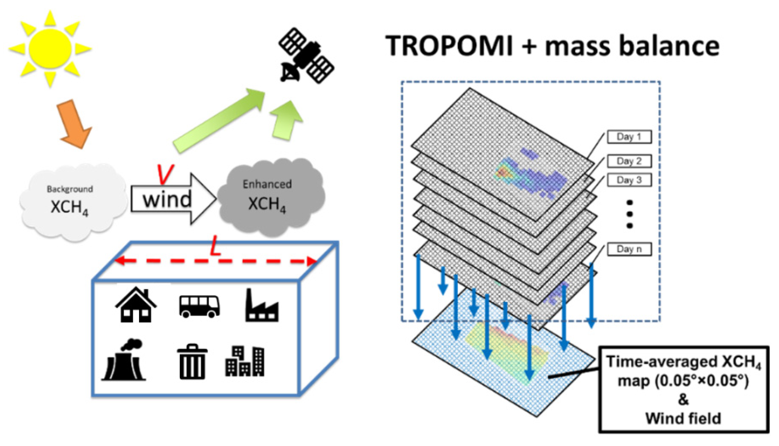
Figure 2.
TROPOMI observations over City of Calgary between 01 January 2020 and 31 December 2022. (a): Pixel-specific coverage map of TROPOMI valid observations; (b & c): The time averaged TROPOMI XCH4 observations; and (d): pixel-specific XCH4 enhancement (ΔXCH4, only pixels with positive enhancements were plotted). City boundaries of Calgary are indicated by the black line. The broader region indicated by the dashed line was used for background XCH4 determination. Facilities reporting in GHGRP are indicated by the blue circles in panel (d), with size denoting the emission magnitude.

Disclaimer/Publisher’s Note: The statements, opinions and data contained in all publications are solely those of the individual author(s) and contributor(s) and not of MDPI and/or the editor(s). MDPI and/or the editor(s) disclaim responsibility for any injury to people or property resulting from any ideas, methods, instructions or products referred to in the content. |
© 2023 by the authors. Licensee MDPI, Basel, Switzerland. This article is an open access article distributed under the terms and conditions of the Creative Commons Attribution (CC BY) license (http://creativecommons.org/licenses/by/4.0/).
Copyright: This open access article is published under a Creative Commons CC BY 4.0 license, which permit the free download, distribution, and reuse, provided that the author and preprint are cited in any reuse.


