
Submitted:
12 December 2023
Posted:
12 December 2023
You are already at the latest version
Abstract
Coastal resources in Lian, Batangas, have undergone significant degradation due to a combination of human activities and natural factors, including sea-level rise, changes in sea-surface temperature, fluctuations in rainfall, increased storm frequency, and sedimentation. This has led to adverse effects on key ecosystems such as corals, mangroves, and seagrasses. To assess the extent of climate change hazards on these coastal resources, a Vulnerability Assessment was conducted in the municipality of Lian, Batangas. The assessment employed a combination of the Coastal Integrity Vulnerability Assessment Toolkit (CIVAT) and Integrated Coastal Sensitivity, Exposure, and Adaptive Capacity to Climate Change (ICSEA-C) guidelines. Additionally, the analysis incorporated detailed mapping using Light Detection and Ranging (LiDAR) data for mangroves and LandSat 8 imagery for corals and seagrasses. The findings at the municipal scale revealed that a staggering 90% of mangroves in Lian, Batangas, were highly vulnerable. This vulnerability was attributed to a high score in intrinsic characteristics and a low adaptive capacity. Similarly, a majority of seagrasses in the area were classified as medium and highly vulnerable at the municipal level. Only 10–20% of seagrasses received low to medium vulnerability scores. Shockingly, almost 100% of the coral reefs in Lian, Batangas, were deemed highly vulnerable, indicating a critical threat to this crucial marine ecosystem.
Keywords:
CIVAT
; climate change hazards
; coastal resources
; corals
; ICSEA-C
; LiDAR data
; LandSat 8
; mangroves
; seagrasses
; vulnerability assessment
1. Introduction
The Philippines, located in the Pacific Rim, is identified as a hotspot for natural disturbances. Recent studies have ranked it as the third most disaster-prone country globally due to its high exposure to natural calamities. Disturbing trends and projections in climate hazards, including increasing air and sea-surface temperatures, rising sea levels, more intense and frequent typhoons, higher rainfall, and acidification, have been observed in the country. These changes pose significant threats to coastal communities and resources, necessitating a well-integrated and urgent response.
To address these challenges, the first step is conducting a vulnerability assessment to understand the specific risks and impacts. The province of Batangas, situated along the Verde Island Passage Marine Corridor, is crucial in global marine biological diversity. Lian, Batangas, with its 19 barangays, features eight coastal barangays covering 0.36191 km2 of mangroves, as reported by NAMRIA in 2010. Talim Bay, a habitat for diverse marine species and corals, is located in this municipality.
Seagrass areas in Lian, Batangas, were assessed in six barangays: Matabungkay, Balibago, Binubusan, Lumaniag, Luyahan, and San Diego, with a total area of approximately 104 hectares. Barangay Lumaniag recorded the highest area, followed by Luyahan, Binubusan, Balibago, San Diego, and Matabungkay. Six seagrass species from three families were observed in these barangays, with Enhalus acoroides, Cymodocea serrulata, Halophila ovalis, Halodule pinifolia, Thalassia hemprichii, and Cymodocea rotundata being the most frequently observed. In 2012, the Department of Environmental and Natural Resources (DENR) conducted an assessment of seagrass areas in Lian. This initiative aimed to monitor and develop a sustainability plan for the existing seagrass species in the area, reflecting a proactive approach toward conservation and environmental management. In this work, vulnerability assessment of coastal resources in climate change is implemented. Three coastal resources which are mangroves, seagrasses, and benthic habitat are subjected to assessment.
2. Methodology
2.1. General Framework
The vulnerability assessment of coastal resources in Lian, Batangas involved the implementation of five major activities, as illustrated in Figure 1. These activities were crucial in gathering comprehensive data and insights for a thorough analysis. The activities include:
- Coastal Resources Mapping: This involved the creation of processed maps for coastal resources, specifically mangroves and aquaculture using LiDAR data, and seagrasses and corals using LandSat 8 images.
- Focus Group Discussion: Engaging in discussions with community members through focus group discussions provided valuable firsthand information about their personal experiences and perspectives on the changes occurring in the coastal areas of Lian.
- Bathymetric Survey: Conducting a bathymetric survey was essential for creating a depth vector layer, a crucial component for the final data integration and scoring in the assessment of seagrasses and corals.
- Data Gathering: This activity involved collecting various types of information about Lian, Batangas, including Comprehensive Land Use Plan (CLUP), Marine Protected Area (MPA) maps, names of fisher folks organizations, ordinances in coastal communities, and other relevant data.
GIS Data Integration: Integration of data gathered from various sources into a Geographic Information System (GIS) allowed for a comprehensive and systematic analysis. This step facilitated the processing of vulnerability assessments for corals, mangroves, and seagrasses. The information gathered through these activities, including data from focus group discussions and key informant interviews, was meticulously analyzed, recorded, and integrated. This comprehensive approach ensured a thorough understanding of the vulnerabilities of corals, mangroves, and seagrasses in the coastal areas of Lian, Batangas. Further details and discussions on each major activity can be found in the preceding sections.
2.1.1. Data Gathering
To enhance the comprehensiveness of the vulnerability assessment of coastal resources in Lian, Batangas, additional data from various government agencies and sources were collected. This supplementary information encompasses key elements such as the Comprehensive Land Use Plan (CLUP), Marine Protected Area (MPA) maps, details about different fisher folk’s organizations, population statistics, and existing research findings on various coastal resources in the area. The gathered data not only contributed to the overall understanding of the local context but also played a crucial role in meeting the criteria necessary for creating a robust vulnerability assessment.
In particular, the research sought additional data to address specific questions related to sensitivity and adaptive capacity. Technical references and statistical records were required to provide thorough and accurate responses to these questions. The gathered data were then categorized based on their relevance to different criteria, as outlined in Table 1. For instance, MPA maps were considered within the governance criterion, which is an essential component of adaptive capacity. On the other hand, CLUP and population density data were associated with anthropogenic disturbances criteria under sensitivity.
This systematic approach to gathering and categorizing additional data ensures a well-rounded and informed vulnerability assessment, taking into account various factors that contribute to the resilience or vulnerability of coastal resources in Lian, Batangas. The utilization of data from government agencies and local government units (LGUs) strengthens the scientific basis of the assessment, providing a foundation for informed decision-making and strategic planning to address the challenges posed by environmental changes.
2.1.2. Coastal Resources Planning
The mapping of mangroves and aquaculture resources was accomplished by extracting information from LiDAR data using Object-Based Image Analysis with the Ecognition software, following established workflows outlined in previous studies [32,33,34]. Concurrently, the resource map for corals and seagrasses was derived from LandSat 8 imagery captured in the same month and year as the LiDAR data acquisition. In the classification of LandSat 8 images, the KNN (K-Nearest Neighbors) algorithm was employed instead of the maximum likelihood classification algorithm. Various vegetation indices served as input layers in the processing of corals and seagrasses.
For mangroves and aquaculture classification, different LiDAR derivatives were utilized, including DSM (Digital Surface Model), NDSM (Normalized Digital Surface Model), slope of DSM, DTM (Digital Terrain Model), CHM (Canopy Height Model), and RGB from orthophotos images. The classification process for mangroves involved the use of height metrics, while aquaculture processing incorporated the slope of DSM and intensity of LiDAR data, aligning with the established workflow [34].
The accuracy assessments for both mangroves and aquaculture indicated a high accuracy rate of over 90%. In the case of corals and seagrasses, the accuracy assessment yielded a score of 87%. The results, illustrated in Figure 2, depict the merged extracted mangroves and aquaculture from LiDAR data. This mapping approach, combining LiDAR and LandSat 8 data, showcases a reliable and accurate representation of coastal resources, providing valuable information for further analysis and the vulnerability assessment of these ecosystems in Lian, Batangas.
The LandSat 8 image data employed for the classification of corals and seagrasses was obtained from the United States Geological Survey (USGS). The satellite captured the image in November 2016, aligning with the same month in which training and validation points were collected for the study. Prior to the classification process, thorough preparation of the LandSat 8 image was carried out. The preparation steps included:
- Radiometric Calibration: Adjusting the pixel values of the image to account for variations in sensor sensitivity and atmospheric conditions.
- Atmospheric Correction using FLAASH: Correcting for atmospheric effects to enhance the accuracy and reliability of the image data.
- Resizing: Adjusting the dimensions of the image to meet the requirements of the classification process.
- Masking: Applying masks to focus the analysis on specific areas of interest and exclude irrelevant information.
Figure 3, presented below, displays the final output of the extracted corals and seagrasses after completing the classification, refinement, and accuracy assessment processes. This meticulous approach to image preparation and classification ensures that the results are accurate and representative of the actual distribution of corals and seagrasses in the coastal areas of interest. The integration of USGS LandSat 8 imagery, coupled with precise image processing techniques, contributes to a reliable foundation for the subsequent stages of the vulnerability assessment of these vital marine ecosystems.
2.1.3. Bathymetric Survey
The bathymetric survey was executed in two distinct and simultaneous phases to comprehensively cover different parts of the coastal area. One team conducted surveys on foot, focusing on very shallow sections of the coastal region. Their objective was twofold: first, to collect points for training and validation purposes, crucial for processing LandSat 8 imagery to extract information about seagrasses and corals; and second, to capture data from the shallow areas not accessible by boat.
Simultaneously, another team conducted a survey of the coastal region using a mounted GNSS (Global Navigation Satellite System) on a boat. This approach allowed for a broader and more efficient coverage of the coastal depths. The points gathered from both teams were processed and merged to generate a comprehensive depth vector layer. The boat survey team specifically acquired seabed depth data with reference to the boat’s position, indicated by latitude and longitude coordinates. Notably, the boat position guides were spaced 200 meters apart, with each data point recorded at a distance of 20 meters. The resulting dataset, represented in Figure 4, illustrates the points gathered through both walking and boat surveys. This integrated approach ensures a detailed and accurate representation of the bathymetry, encompassing shallow coastal areas and deeper regions, essential for a thorough understanding of the underwater topography in the study area.
Following the bathymetric survey, the collected data underwent a comprehensive combination and processing phase to generate both a depth vector layer and a contour layer. Reclassified values for depth were then utilized as input for the sensitivity criteria in the assessment of seagrasses and corals. The resulting processed bathymetric data is depicted in Figure 5, representing the final output of this phase.
For a more detailed understanding, the reclassified values derived from the bathymetric survey data were employed as a key component in establishing the sensitivity criteria for both corals and seagrasses. The translation of sensitivity criteria for depth, derived from the bathymetric survey data, is presented in Table 2. This table provides a comprehensive overview, including qualitative and quantitative ratings corresponding to the depth values. These sensitivity criteria are pivotal in evaluating the impact of varying depths on the health and resilience of corals and seagrasses in the study area.
2.1.4. Focus Group Discussion and KII
A total of 85 participants engaged in the Focus Group Discussion (FGD) across various coastal barangays in Lian. Predominantly male, aged between 30 and 50 years, most participants were fishermen affiliated with fisherman organizations, residing in coastal areas for over 10 years. Notably, in Luyahan and Matabungkay, where no distinct fishermen organizations existed, villagers included in the FGD were either fishermen or fishermen’s wives, each with over 10 years of residency.
The FGD comprised two main activities: participatory mapping and structured discussions. During participatory mapping, participants delineated coastal resources in Lian using provided maps, successfully identifying the locations of mangroves, corals, seagrasses, and aquaculture. Their understanding and knowledge about the importance of each resource were also probed. The second part involved specific questions addressing the health and threats of coastal resources, habitat conditions, resource locations, river and agricultural land locations, aquaculture details, fishing grounds, income, fishing practices, alternative livelihoods, water quality, illegal activities, municipal ordinances, and other concerns. These responses were compiled based on combined guidelines from Coastal Integrity Vulnerability Assessment Toolkit (CIVAT) and Integrated Coastal Sensitivity, Exposure, and Adaptive Capacity to Climate Change (ICSEA-C).
Additionally, Key Informant Interviews (KII) with five municipal experts aimed to validate FGD data using the same set of questionnaires. Responses were interpreted based on CIVAT and ICSEA-C guidelines, addressing sensitivity, adaptive capacity, human intervention, governance, and habitat morphology criteria. Results, as illustrated in Figure 6, revealed varying scales across barangays, with ratings from 1 to 5 (lowest to highest) for anthropogenic disturbances, human intervention and governance, and habitat morphology. These ratings will undergo rescaling in the final Vulnerability Assessment (VA) stage.
2.1.5. Focus Group Discussion and KII
GIS data Integration includes processed mangroves and aquaculture from LiDAR data, processed seagrasses and corals from LandSat 8 Image, generated exposure layers for each coastal resources, generated sensitivity layers, and generated adaptive capacity layers. All data from Bathymetric survey, FGD, KII, resources maps, additional data gathered were rescaled and translated using the combined guidelines of CIVAT and ICSEA-C, these values where attributed to GIS layers respectively as sensitivity, exposure, or adaptive capacity depending on the guidelines that fits them accordingly.
2.2. VA Framework
The concept of vulnerability, as defined in [38], refers to “the degree to which a system is susceptible to, or unable to cope with, adverse effects of climate change, including climate variability and extremes.” This definition encompasses three key components: exposure to climate hazards, sensitivity to hazards, and adaptive capacity to hazards [38]. The exposure in this study comprises Long-term and Extreme Sea Surface Temperature, Extreme and Changes in Precipitation, Sea-Level Rise, Storm Surge (specifically for mangroves), and Storm Frequency. Sensitivity criteria include Intrinsic Characteristics, Coastal Integrity, Anthropogenic Disturbances, and Habitat Characteristics. Sensitivity and exposure were considered together to assess potential impacts, following the methodology proposed by [39]. Adaptive capacity criteria consist of scores related to Governance, Human Intervention, and Habitat Morphology.
To evaluate vulnerability, the potential impact was cross-tabulated with adaptive capacity, applying this framework to each coastal resource. The preceding paragraphs will delve into the detailed framework for each coastal resource. Figure 7 visually represents the comprehensive framework employed in performing the Vulnerability Assessment (VA). This structured approach ensures a systematic evaluation of vulnerability by considering the unique characteristics and interactions of each coastal resource in response to climate hazards.
2.2.1. Exposure
The exposure data utilized in this study was derived from the research conducted by the University of the Philippines – Marine Science Institute (UP-MSI), focusing on geographic factors. This exposure layer incorporates various elements, including long-term and extreme sea-surface temperature (IOT, EHE), extreme and changes in precipitation (ER, DWB), and sea-level rise (SLR). The ratings are presented in cluster form, with the municipality of Lian, Batangas falling under cluster III. Figure 8 provides a visual representation of the exposure layer, covering the entire Philippines. As outlined in Table 3, specific ratings were assigned to each factor: IOT received a score of 2, EHE scored 4, ER obtained a score of 1, DWB was rated 5, SLR received a score of 5, resulting in an average of 3.4 for all entries under the exposure layer. Notably, DWB and SLR garnered the highest scores of 5, indicating their elevated significance in the exposure assessment, while ER received the lowest score of 1.
This exposure layer, with its distinct ratings and cluster categorization, provides a comprehensive overview of the geographic factors contributing to the vulnerability of the municipality of Lian, Batangas, and is instrumental in understanding and assessing the potential impacts of climate hazards on coastal resources in the region.
2.2.1.1. Storm Surge
The storm surge map employed in this study is derived from the Storm Surge Hazard map, specifically based on the predicted storm surge height of 5 meters (Advisory 4). This map, illustrated in Figure 9, is particularly relevant for assessing the potential impact on mangroves, given that a 5-meter storm surge can significantly affect these coastal ecosystems. The Storm Surge Hazard map was generated as part of the DOST-Project NOAH (Nationwide Operational Assessment of Hazards) program, with its main office situated at the National Institute of Geological Sciences (NIGS), University of the Philippines.
It’s crucial to note that this exposure layer was exclusively utilized for the evaluation of mangroves. This specific map provides valuable information about potential storm surge impacts, aiding in a focused and detailed assessment of the vulnerability of mangroves in the study area.
2.2.1.2. Sea Surface Temperature
The Philippines has witnessed a notable increase of 0.3 degrees Celsius in sea surface temperature [40]. Recorded sea surface temperatures spanning the period from 1985 to 2006 were consistently higher compared to other areas within the Coral Triangle in Southeast Asia [8]. Sea surface temperature is a critical factor influencing the health of biodiversity across various ecosystems. Elevated sea surface temperatures can lead to coral bleaching, a phenomenon that adversely affects fish production and yields.
Figure 10, presented below, depicts a time series of sea surface temperatures based on the study conducted by [8]. This visualization provides a chronological overview, highlighting the trends and variations in sea surface temperatures over the specified period. The observed increase in sea surface temperature underscores the significance of understanding and monitoring these changes to assess their potential impact on marine ecosystems and fisheries.
2.2.1.3. Sea – level rise
The rise in sea levels is a contributing factor to accelerated beach soil erosion, posing threats not only to communities residing in coastal areas but also to the coastal resources themselves [7]. A study [41] projecting a high emission scenario anticipates a sea-level rise of 1.0 meter by the year 2080. However, observations in the Philippines indicate a more recent increase ranging between 0.2 to 0.4 meters in sea level rise [42]. This data emphasizes the real and current impact of rising sea levels in the country, underscoring the need for proactive measures to mitigate the adverse effects on coastal communities and their valuable resources.
2.2.1.4. Storm frequency
The frequency of Category 5 typhoons passing within a 300 km-radius of each coastal site was tallied over a 30-year record and subsequently mapped by [43], as illustrated in Figure 11. This mapping provides a visual representation of the occurrence and distribution of these extremely powerful typhoons in proximity to each coastal location over the specified time frame.
2.2.2. Sensitivity
The sensitivity criteria for mangroves, seagrasses, and corals were adopted from two sources: the study by [44] titled “Development of GIS-Based Coastal Resources Vulnerability Assessment Framework for Coastal Resources in the Philippines” and the “Vulnerability Assessment Tools for Coastal Ecosystems: A Guidebook” prepared by the Marine Environment and Resources Foundation, Inc. [45].
For mangroves, the sensitivity criteria under intrinsic characteristics include proximity to coastal development, proximity to aquaculture, the condition of the beach in the last 12 months, whether the coastline is prone to erosion, width of the shore platform, and steepness of the coast. Anthropogenic disturbance criteria encompass solid waste accumulation and management, presence of tourism activities and other activities, coastal mining and/or wood harvesting/deforestation, conversion of coastal lands from rural-agricultural to residential and industrial use, and pollution such as oil spills, construction of landfills, and unregulated dumping. In habitat characteristics, sensitivity criteria involve the age of the mangrove stand, the state of the natural forest, the kind of mangrove species present, and the population density of large mangroves compared to small mangroves.
For seagrasses, anthropogenic disturbance sensitivity criteria include water quality, solid waste accumulation and management, presence of tourism and other activities, catch rates, catch composition, dependence on fishing, coastal and offshore mining, and conversion of coastal lands from rural to other uses. Intrinsic characteristics criteria involve proximity to coastal development, proximity to aquaculture, proximity to river outlets, depth of seagrass habitat, changes in the beach in the last 12 months, proneness of the coastline to erosion, width of the shoreline, width of the shore platform, and steepness of the coast. Habitat characteristics include the presence of key species, extent of seagrass cover, and composition of seagrass beds.
For corals, intrinsic characteristics sensitivity criteria include proximity to coastal development, proximity to aquaculture, proximity to river outlets, depth, changes in the beach in the past 12 months, proneness of the coastline to erosion, width of the shore platform, and coastal steepness. Anthropogenic disturbance criteria are the same as those for seagrasses. Habitat characteristics include the presence of key species, dominant growth forms, and the condition of the coastline lined by coral reefs/communities. Detailed tables presenting this data are not included in this text.
2.2.3. Adaptive Capacity
The criteria used for the indicators of Adaptive Capacity were adopted from two sources: the study by [44] titled “Development of GIS-Based Coastal Resources Vulnerability Assessment Framework for Coastal Resources in the Philippines” and the “Vulnerability Assessment Tools for Coastal Ecosystems: A Guidebook” prepared by the Marine Environment and Resources Foundation, Inc. [45].
For the governance component of adaptive capacity for mangroves, the criteria include the existence of local ordinances, community support, and local knowledge, as well as aspects related to Marine Protected Areas (MPAs), such as their existence, extent of focus, and the need for expansion. Maps of MPAs in Lian, Batangas, are illustrated in Figure 12a,b.
Under human intervention, criteria comprise habitat restoration efforts, awareness of coastal resources within communities, and the extent of coastal modifications (including pier wharf and seawall construction, reclamation, and foreshore use). In habitat morphology, criteria include the presence of refuge sites (buffer zones for community extension) and the presence of adjacent habitats (other coastal resources). This framework provides a structured approach to evaluating the adaptive capacity of mangroves, encompassing governance, human intervention, and habitat morphology. The inclusion of specific criteria enables a comprehensive assessment of the resilience and adaptive capabilities of mangrove ecosystems in the study area.
In assessing adaptive capacity for seagrasses, the governance criteria parallel those used for mangroves. Under human intervention, criteria include the dependence on fisheries’ resources, average fishing experience per fisher, effectiveness of fishery resource management plans, habitat restoration efforts, awareness of coastal resources, awareness of the importance of each coastal resource, and the extent of coastal modifications. Habitat morphology criteria for adaptive capacity of seagrasses encompass the presence of adjacent habitats, the condition of Enhalus acoroides (density composition among seagrasses), and the continuity of seagrass beds.
For corals, governance criteria mirror those used for mangroves and seagrasses. Human intervention criteria for corals align with those used for seagrasses. In terms of habitat morphology, criteria include coral cover health, the presence of massive corals compared to branching ones, the comparison of large colonies to small colonies of species, the reduction in coral diversity, and the presence of adjacent habitats (other coastal resources). This consistent framework ensures a comprehensive and comparable evaluation of the adaptive capacity of seagrasses and corals, considering governance, human intervention, and habitat morphology as integral components of their resilience.
2.2.4. Scoring and Rescaling
The Coastal Integrity Vulnerability Assessment Toolkit (CIVAT) guidelines, derived from a study conducted by the University of the Philippines - Marine Science Institute (UP-MSI), were employed to score various criteria for exposure, sensitivity, and adaptive capacity. These guidelines not only facilitated the initial scoring based on raw numerical values but also aided in the subsequent rescaling of scores into descriptive categories such as High, Medium, and Low.
A combination of criteria from Integrated Coastal Sensitivity, Exposure, and Adaptive Capacity to Climate Change (IC-SEA C) and CIVAT was utilized for the assessment of sensitivity and adaptive capacity. Additionally, storm frequency and storm surge were integrated into the exposure layer. However, for the mangrove vulnerability assessment, the team specifically utilized storm surge.
The exposure map in Figure 11 served as the basis for scoring storm frequency of Category 5 typhoons. The scores for exposure indicators were then rescaled according to the CIVAT guidelines. This structured approach ensures a comprehensive and standardized evaluation of the vulnerability of coastal resources, particularly mangroves, by considering exposure to extreme weather events.

Table 4.
Exposure Scores for Storm Frequency.
| Barangay | Score | Numerical Score |
|---|---|---|
| Balibago | Low | 2 |
| Binubusan | Low | 2 |
| Lumaniag | Low | 2 |
| Luyahan | Low | 2 |
| Matabungkay | Low | 2 |
| San Diego | Medium | 3 |
Scores and rescaled values of Sensitivity criteria for mangroves, and seagrasses proximity to coastal development (Table 5 and Table 6), proximity to aquaculture areas (Table 7 and Table 8), proximity to river outlets (Table 9), and Depth criteria scores for seagrasses and corals are shown in Table 10.
The proximity of corals to Marine Protected Areas (MPAs) was assessed, and the scores were subsequently rescaled. This process involved plotting the coordinates provided by the Municipal Environment and Natural Resources Office (MENRO) in Lian, Batangas. Table 11 outlines the scoring criteria utilized for assessing the adaptive capacity of corals in proximity to MPAs. Similarly, criteria for scoring the proximity of corals to coastal development can be found in Table 12. Additionally, Table 13 provides the scoring criteria for the proximity of corals to river outlets. These structured criteria and scoring systems ensure a systematic evaluation of the adaptive capacity of corals in relation to their proximity to MPAs, coastal development, and river outlets.
The rubrics employed for identifying potential impacts and conducting the overall vulnerability assessment for each coastal resource were derived from the study conducted by [44]. The rescaling of data obtained from the Focus Group Discussion (FGD) followed the methodology outlined in the work of [45].
Following the Vulnerability Assessment (VA) framework illustrated in Figure 7, ratings for potential impacts associated with Intrinsic Characteristics, Governance, Anthropogenic Activities, and Habitat Characteristics were determined based on the sensitivity and exposure ratings [45], as depicted in Figure 13. Subsequently, Table 4, Table 5, Table 6, Table 7 and Table 8, along with other data, were rescaled using the Coastal Integrity Vulnerability Assessment Toolkit (CIVAT) guidelines, which employ descriptive ratings such as High, Medium, and Low, corresponding to the original ratings of Very High, High, Medium, Low, and Very Low. While the specific computations are not presented here, the potential impacts for each of these characteristics were calculated using the field calculator in ArcMap.
Ratings for Vulnerability of each Intrinsic Characteristics and Governance, Anthropogenic Activities, and Habitat Characteristics were based on the ratings on Potential Impact and Adaptive Capacity as shown in Figure 14.
The ratings for the Overall Vulnerability of each coastal resource were determined based on the ratings for Intrinsic and Governance, Anthropogenic, and Habitat Vulnerabilities, as outlined in [44]. The rubric for Overall Vulnerability, considering Anthropogenic Characteristics, Intrinsic Properties and Governance, and Habitat Characteristics, is illustrated in Figure 15. This rubric serves as a guideline for assessing the combined impact of these factors on the overall vulnerability of each coastal resource.
3. Results and Discussion
The Vulnerability Assessment (VA) results for mangroves indicate that the majority of the four barangays are highly vulnerable to climate change, with Bungahan, Binubusan, Luyahan, and Matabungkay showing elevated vulnerability scores. The high sensitivity scores primarily stem from intrinsic characteristics, specifically the proximity to urban areas and aquaculture. These factors, combined with low scores in governance, contribute to high potential impact scores and an overall high vulnerability related to intrinsic characteristics.
In contrast, some parts of Binubusan and Luyahan received medium scores. These scores result from a combination of medium scores in exposure and sensitivity criteria, which constitute the intrinsic characteristic component, leading to a moderate potential impact. These areas also exhibit medium scores in governance, habitat morphology, and human intervention. The final vulnerability scores for these specific parts of Binubusan and Luyahan are categorized as medium.
Lumaniag, San Diego, Balibago, and some parts of Matabungkay received low vulnerability scores. Despite high scores in intrinsic characteristics, these scores were counterbalanced by low scores in habitat characteristics. The compensation of a high potential impact for intrinsic characteristics with a low potential impact in habitat characteristics, along with a medium potential impact in anthropogenic disturbances, contributes to lower vulnerability. High scores for human intervention, medium scores for habitat morphology, and medium scores for governance collectively play a role in reducing vulnerability in these barangays.
Figure 16 illustrates the final output of the mangroves VA in GIS, providing a visual representation of the vulnerability levels across the study area. Graph representations for sensitivity (Figure 17), adaptive capacity (Figure 18), and exposure (Figure 19) are also included to enhance understanding of the respective levels in each barangay.
In the seagrass Vulnerability Assessment (VA) results, most parts of Binubusan received a high score due to a medium score in intrinsic characteristics, along with medium values for exposure, anthropogenic activities, and habitat characteristics. These factors collectively contribute to medium potential impact scores for intrinsic characteristics, anthropogenic disturbances, and habitat characteristics, coupled with medium values for adaptive capacity, resulting in an overall high vulnerability.
In the case of Bungahan, despite obtaining medium scores in anthropogenic disturbances, intrinsic characteristics, and habitat morphology, it still received a high final VA score. This is attributed to governance and human intervention, which received medium scores, along with a low value for habitat morphology. The roles of governance, habitat morphology, and human intervention are significant in yielding medium and low vulnerability scores in most parts of Lian, despite having high scores in intrinsic characteristics.
The final output map illustrating the level of vulnerability of seagrasses to climate change hazards is presented in Figure 20. This map provides a visual representation of the vulnerability levels across the study area for seagrasses.
Graphs representations of sensitivity (Figure 21), adaptive capacity (Figure 22), and exposure (Figure 23) are can be see below.
In the Corals Vulnerability Assessment (VA) results, only San Diego and a small part of Prenza received high vulnerability scores. This high vulnerability is primarily attributed to elevated scores in habitat and intrinsic characteristics, despite having medium scores in exposure, governance, and human intervention (criteria of adaptive capacity), which collectively influence the overall vulnerability score. Luyahan, Binubusan, and Balibago obtained medium scores, while Lumaniag and Matabungkay received low scores.
The presence of high tourism activities, categorized under anthropogenic activities, negatively impacts coastal resources, contributing to the medium vulnerability scores for Luyahan, Binubusan, and Balibago. These three barangays exhibit medium scores in intrinsic characteristics, low governance, high human intervention, and high habitat morphology, all of which affect their vulnerability scores.
Matabungkay stands out with a low vulnerability score, primarily due to its low score in anthropogenic disturbances, despite having medium scores in habitat characteristics and high scores in intrinsic characteristics. The combination of a high score in habitat morphology and medium scores in human intervention and governance contributes to the low vulnerability score for this barangay.
In the case of Lumaniag, a low score in anthropogenic disturbances and habitat characteristics significantly influences the overall vulnerability score. With a high score in habitat morphology and medium scores in governance and human intervention, Lumaniag achieves a low vulnerability score.
Figure 24 depicts the final map output of the Corals VA, illustrating the vulnerability levels of corals to climate change hazards across the study area.
Graphs of sensitivity (Figure 25), adaptive capacity (Figure 26), and Exposure (Table 26) are shown below.
Based on the data summary, Mangroves exhibit high vulnerability in Binubusan, Bungahan, Luyahan, Matabungkay, and Balibago, while Lumaniag and San Diego show a low vulnerability. For seagrasses, Binubusan, Luyahan, and Bungahan display high vulnerability, San Diego and Balibago have a medium vulnerability, and Lumaniag and Matabungkay exhibit low vulnerability. In the case of corals, only San Diego has a high vulnerability, Binubusan, Luyahan, and Balibago show a medium vulnerability, and Matabungkay and Lumaniag have a low vulnerability.
Considering all three coastal resources, Binubusan and Luyahan emerge as the barangays with the most vulnerable coastal resources. Bungahan, with vulnerabilities in only two resources, also faces considerable risk. Lumaniag, on the other hand, appears to be the least vulnerable among the barangays.
A visual representation of the Vulnerability Assessment (VA) results for mangroves, seagrasses, and corals is depicted in Figure 27, providing a graphical overview of the vulnerability levels across the different coastal resources in each barangay.
4. Conclusion
The results suggest that integrating GIS into the Vulnerability Assessment (VA) of coastal resources to climate change hazards yields favorable outcomes, particularly for mangroves, where features extracted from LiDAR datasets and Orthophotos demonstrate good results. The VA results for seagrasses and corals, although utilizing LandSat 8 images, also prove to be satisfactory. Key factors influencing VA outcomes include input data from Focus Group Discussions (FGD), bathymetric surveys, and other secondary data. This underscores the importance of integrating various scientific, social, and historical findings, data, and records for accurate VA, following the guidelines of combined Coastal Integrity Vulnerability Assessment Toolkit (CIVAT) and Integrated Coastal Sensitivity, Exposure, and Adaptive Capacity to Climate Change (ICSEA-C).
The combination of different toolkits in conducting VA for coastal resources is not only applicable but also enhances accuracy. GIS integration provides a visual interpretation of the vulnerability of coastal resources to climate change hazards. It serves as a valuable tool for conveying information to the public, illustrating the impact of climate change on coastal resources. Human activities significantly contribute to the outcomes of VA, with seagrasses being particularly affected by climate change hazards. The results indicate that 70–80% of mangroves in the area are highly vulnerable to climate change hazards. The presence of Marine Protected Areas (MPA) greatly influences VA results for corals.
Conducting VA at the barangay level proves to be a valuable assessment, aiding in prioritizing areas for future rehabilitation, especially when facing budget constraints at the municipal government level. Overall, the study emphasizes the importance of comprehensive data integration and GIS application in conducting effective Vulnerability Assessments for coastal resources, highlighting the urgency of addressing the impact of climate change on these vital ecosystems.
5. Recommendation
Future researchers can explore the use of benthic LiDAR data for coral and seagrass classification, as this study relied on LandSat 8 imagery. Additionally, conducting vulnerability assessments using alternative guidelines beyond CIVAT and ICSEA-C could provide further insights. The inclusion of additional criteria from diverse guidelines can enhance the depth of vulnerability research. Different methods for gathering information, aside from focus group discussions, could be employed in future studies. Implementing proper zoning for urban communities near coastal resources is crucial to prevent further degradation. Prohibiting sand mining for residential building purposes is essential. Regular dissemination of information to locals about the impact of climate change, the effects of illegal activities, and related issues should be prioritized. Supporting local income through livelihood programs during non-fishing seasons can reduce reliance on illegal fishing activities.
Effective implementation of local ordinances for coastal resource protection is vital, with active involvement from local communities. Measures to combat illegal fishing practices, such as using dynamite and cyanide, must be urgently addressed. Enhancing adaptive capacity measures, especially in areas with high and medium vulnerability, is essential for building resilience. Continuous tree planting of mangroves, using appropriate species for each area, can help minimize coastal soil erosion. Strict implementation of solid waste management, especially in coastal areas, is critical for environmental preservation.
Acknowledgments
This study received support from the Department of Science and Technology (DOST) grant and benefited from the collaboration with Mapúa University and the Philippine Council for Industry, Energy and Emerging Technology Research and Development (PCIEERD) through the Phil-LiDAR 2 Program: National Resource Inventory of the Philippines Using LiDAR and other Remotely Sensed Data. Special appreciation goes to the following entities and individuals: UPD – TCAGP, particularly Dr. Ariel Blanco, the program leader of Phil-LiDAR 2; Mapua University (Mapua-Phil LiDAR 2); and the entire team of CoastMap Components of UPD for hosting training sessions and seminars on GIS and RS techniques and applications. Their contributions played a crucial role in the successful execution of this study.
References
- M. Björk, F. Short, E. Mcleod and S. Beer, Managing seagrasses for resilience to climate change. Gland: IUCN International Union for Conservation of Nature, 2008.
- L. David, P. Sereywath, I. Radjawane, E. Saleh, F. Lansigan and P. Tantichodok, Integrated Vulnerability Assessment of Coastal Areas in the Southeast Asian Region. South-East Asia: APN Asia Pacific Network for Global Change Research, 2008.
- E. Horstman, C. Dohmen-Janssen, P. Narra, N. van den Berg, M. Siemerink and S. Hulscher, “Wave attenuation in mangroves: A quantitative approach to field observations”, Coastal Engineering, vol. 94, pp. 47-62, 2014.
- N. España, W. Licuanan and P. Aliño, “Resilience to thermal stress of coral communities in Talim Bay, Lian, Batangas”, International Journal of Philippine Science and Technology, vol. 8, no. 2, pp. 37-40, 2015.
- S. Harmeling, Global Climate Risk Index 2011. Berlin: Germanwatch e.V., 2010, pp. 1-23.
- N. Knowlton and J. Jackson, Corals and Coral Reefs. Washington DC: Elsevier, 2016.
- M. Mendoza, B. The, H. Naret, V. Ballaran and J. Ballaran, “Assessing Vulnerability to Climate Change Impacts in Cambodia, the Philippines and Vietnam: An Analysis at the Commune and Household Level”, Journal of Environmental Science and Management, vol. 17, no. 2, pp. 78-91, 2014.
- E. Peñaflor, W. Skirving, A. Strong, S. Heron and L. David, “Sea-surface temperature and thermal stress in the Coral Triangle over the past two decades”, Coral Reefs, vol. 28, no. 4, pp. 841-850, 2009.
- B. Polidoro, K. Carpenter, L. Collins, N. Duke, A. Ellison, J. Ellison, E. Farnsworth, E. Fernando, K. Kathiresan, N. Koedam, S. Livingstone, T. Miyagi, G. Moore, V. Ngoc Nam, J. Ong, J. Primavera, S. Salmo, J. Sanciangco, S. Sukardjo, Y. Wang and J. Yong, “The Loss of Species: Mangrove Extinction Risk and Geographic Areas of Global Concern”, PLoS ONE, vol. 5, no. 4, p. e10095, 2010.
- J. Primavera, R. Sadaba, M. Lebata and J. Altamirano, Handbook of Mangroves in the Philippines - Panay. Iloilo: Southeast Asian Fisheries Development Center Aquaculture Department UNESCO Man and the Biosphere, 2004.
- M. Rasheed, H. Taylor, R. Coles and L. McKenzie, Coastal seagrass habitats at risk from human activity in the Great Reef World Heritage Are: Review of areas to be targeted for monitoring.. Cairns: Reef and Rainforest Research Centre Limited., 2018, p. 122.
- R. Robles, L. Javid, R. Arcilla and W. Licuanan, “Panel Data Regression Model for Coral Cover.” in DLSU Research Congress 2015, Manila, 2015, p. 1.
- White and A. Cruz-Trinidad, The values of Philippine coastal resources. Cebu City, Philippines: Coastal Resource Management Project, 2000.
- S. Saul and S. Purkis, “Semi-Automated Object-Based Classification of Coral Reef Habitat using Discrete Choice Models”, Remote Sensing, vol. 7, no. 12, pp. 15894-15916, 2015.
- E. Boak and I. Turner, “Shoreline Definition and Detection: A Review”, Journal of Coastal Research, vol. 214, pp. 688-703, 2005.
- Ardalan and M. Rezvani, “Improved vessel squat modeling for hydrographic and navigation applications using kinematic GNSS positioning”, GPS Solutions, vol. 18, no. 2, pp. 253-262, 2013.
- R. Boquiren, G. Di Carlo, and M.C. Quibilan (Eds), Climate Change Vulnerability Assessment of the Verde Island Passage, Philippines. Arlington, Virginia, USA: Technical report. Conservation International, 2010.
- National Climate Change Action Plan 2011-2028. Climate Change Commission, Office of the President of the Philippines., 2016.
- M. Tiquio. Review of Vulnerability Assessment Approaches and Methods. Quezon City, Philippines: Conservation International – Philippines, 2010.
- L. Bizikova, J. Bellali, Z. Habtezion, M. Diakhite and L. Pinter, IEA Training Manual Volume 2: Vulnerability and impact assessments for Adaptation to Climate Change (VIA Module). UNEP , iisd and unitar, 2009.
- H. Füssel and R. Klein, “Climate Change Vulnerability Assessments: An Evolution of Conceptual Thinking”, Climatic Change, vol. 75, no. 3, pp. 301-329, 2006.
- E. Mcleod, J. Hinkel, A. Vafeidis, R. Nicholls, N. Harvey and R. Salm, “Sea-level rise vulnerability in the countries of the Coral Triangle”, Sustainability Science, vol. 5, no. 2, pp. 207-222, 2010.
- L. Bengtsson, K. Hodges and E. Roeckner, “Storm Tracks and Climate Change”, Journal of Climate, vol. 19, no. 15, pp. 3518-3543, 2006.
- C. Harley, A. Randall Hughes, K. Hultgren, B. Miner, C. Sorte, C. Thornber, L. Rodriguez, L. Tomanek and S. Williams, “The impacts of climate change in coastal marine systems”, Ecology Letters, vol. 9, no. 2, pp. 228-241, 2006.
- P. Abuodha and C. Woodroffe, International assessments of the vulnerability of the coastal zone to climate change, including an Australian perspective. Canberra, A.C.T.: Australian Greenhouse Office, 2006.
- M. Parry, O. Canziani, J. Palutikof, P. van der Linden and C. Hanson (Eds), IPCC: 2007 Climate Change 2007: Impacts, Adaptation and Vulnerability. Contribution of Working Group II to the Fourth Assessment Report of the Intergovernmental Panel on Climate Change. Cambridge, UK: Cambridge University Press, 2007, pp. 1-966.
- F. Siringan, R. Berdin, C. Jaraula, C. Remotigue, M. Yacat- Sta. Maria and P. Zamora, A challenge for coastal management: large and rapid shoreline movements in the Philippines. Know Risk. United Nations, 2005, pp. 218-219.
- E. Thieler and E. Hammar-Klose, “National Assessment of Coastal Vulnerability to Sea-Level Rise: Preliminary Results for the U.S. Atlantic Coast”, USGS, 1998. [Online]. Available: https://pubs.usgs.gov/of/1999/of99-593/. [Accessed: 16- Apr- 2018].
- K. Brander, “Global fish production and climate change”, Proceedings of the National Academy of Sciences, vol. 104, no. 50, pp. 19709-19714, 2007. Sciences of the United States of America (PNAS). 104 (50): 19709-19714.
- L. Fernandes, A. Green, J. Tanzer, A. White, P. Aliño, J. Jompa, P. Lokani, A. Soemodinoto, M. Knight, R. Pomeroy, H. Possingham, B. Pressey and S. Kilarski, Biophysical principles for designing resilient networks of marine protected areas to integrate fisheries, biodiversity and climate change objectives in the Coral Triangle. Report prepared by The Nature Conservancy for the Coral Triangle Support Partnership, 2012, p. 152.
- W. Licuanan, P. Aliño, W. Campos, G. Castillo and M. Juinio- Menez, “A decision support model for determining sizes of marine protected areas: biophysical considerations”, Philippine Agricultural Scientist, vol. 89, no. 1, pp. 507-519, 2006.
- L. David, R. Pula, A. Ballado and S. Sarte, “Mapping inland aquaculture from orthophoto and LiDAR data using object-based image analysis”, in 2016 IEEE Region 10 Humanitarian Technology Conference (R10-HTC), Agra, India, 2016.
- L. David, R. Pula, S. Sarte and A. Ballado, “MAPPING FRESHWATER AQUACULTURE FROM LIDAR INTENSITY IMAGE USING OBJECT-BASED IMAGE ANALYSIS”, in 37th Asian Conference on Remote Sensing, Colombo, Sri Lanka, 2016.
- L. David, R. Pula, S. Sarte and A. Ballado, “ASSESSMENT OF LIDAR-DERIVED HEIGHT METRICS FOR MAPPING MANGROVE FOREST USING OBJECT-BASED METHOD”, in 37th Asian Conference on Remote Sensing, Colombo, Sri Lanka, 2016.
- R. Zetter, World Disasters Report 2012. Geneva, Switzerland: International Federation of Red Cross and Red Crescent Societies, 2012.
- K. Carpenter and V. Springer, “The center of the center of marine shore fish biodiversity: the Philippine Islands”, Environmental Biology of Fishes, vol. 72, no. 4, pp. 467-480, 2005.
- Department of Environmental and Natural Resources Foreign Assisted Projects. Quezon City, Philippines: DENR, 2012.
- J. McCarthy, Climate change 2001. Cambridge, UK: Cambridge University Press, 2001.
- E. Allison, A. Perry, M. Badjeck, W. Neil Adger, K. Brown, D. Conway, A. Halls, G. Pilling, J. Reynolds, N. Andrew and N. Dulvy, “Vulnerability of national economies to the impacts of climate change on fisheries”, Fish and Fisheries, vol. 10, no. 2, pp. 173-196, 2009.
- C. David, “Mining: A New Challenge for the Philippines”, Geotimes, vol. 53, no. 3, p. 59, 2008.
- R. Perez, L. Amadore and R. Feir, “Climate change impacts and responses in the Philippines coastal sector”, Climate Research, vol. 12, pp. 97-107, 1999.
- M. Hulme and N. Sheard, Climate Change Scenarios for Australia. Norwich, UK: Climatic Research Unit at University of East Anglia, 1999.
- C. Villanoy, E. Salamante and O. Cabrera, Chapter 3: Exposure: waves and storm surges. In: MERF. 2013. Vulnerability Assessment Tools for Coastal Ecosystems: A Guidebook. Marine Environment and Resources Foundation, Inc. Quezon City, Philippines, 2013.
- Songcuan and M. Santos, “Adaptive Strategies in Coping with Climate Variability: Experience of Philippine Traditional Indigenous Fishers”, Fish for the People, vol. 5, no. 11, pp. 2-9, 2013.
- MERF, Vulnerability Assessment Tools for Coastal Ecosystems: A Guidebook. Marine Environment and Resources Foundation, Inc. Quezon City, Philippines, 2013, pp. 1-162.
Figure 1.
Activities conducted to complete VA.
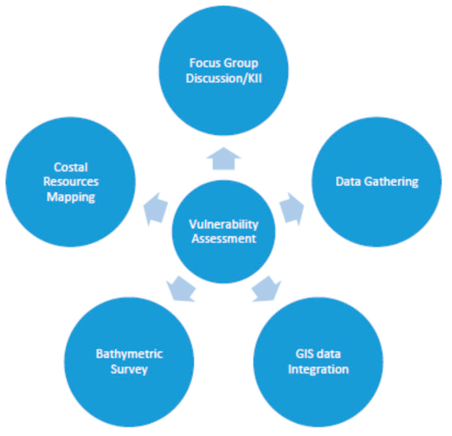
Figure 2.
Extracted Mangroves and Aquaculture from Lian, Batangas from LiDAR Data. (a) Extracted Mangroves (green) and Aquaculture (blue), North; (b) )Extracted Mangroves (green) and Aquaculture (blue), South.
Figure 2.
Extracted Mangroves and Aquaculture from Lian, Batangas from LiDAR Data. (a) Extracted Mangroves (green) and Aquaculture (blue), North; (b) )Extracted Mangroves (green) and Aquaculture (blue), South.
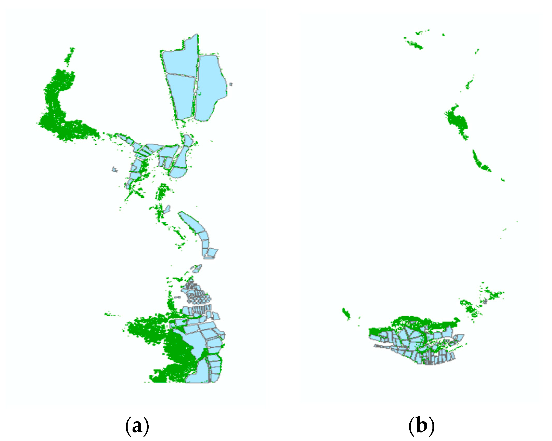
Figure 3.
Final Output of Corals and Seagrasses Extracted from LandSat 8 Image. (Blue) represents the extracted corals and green represents seagrasses.
Figure 3.
Final Output of Corals and Seagrasses Extracted from LandSat 8 Image. (Blue) represents the extracted corals and green represents seagrasses.
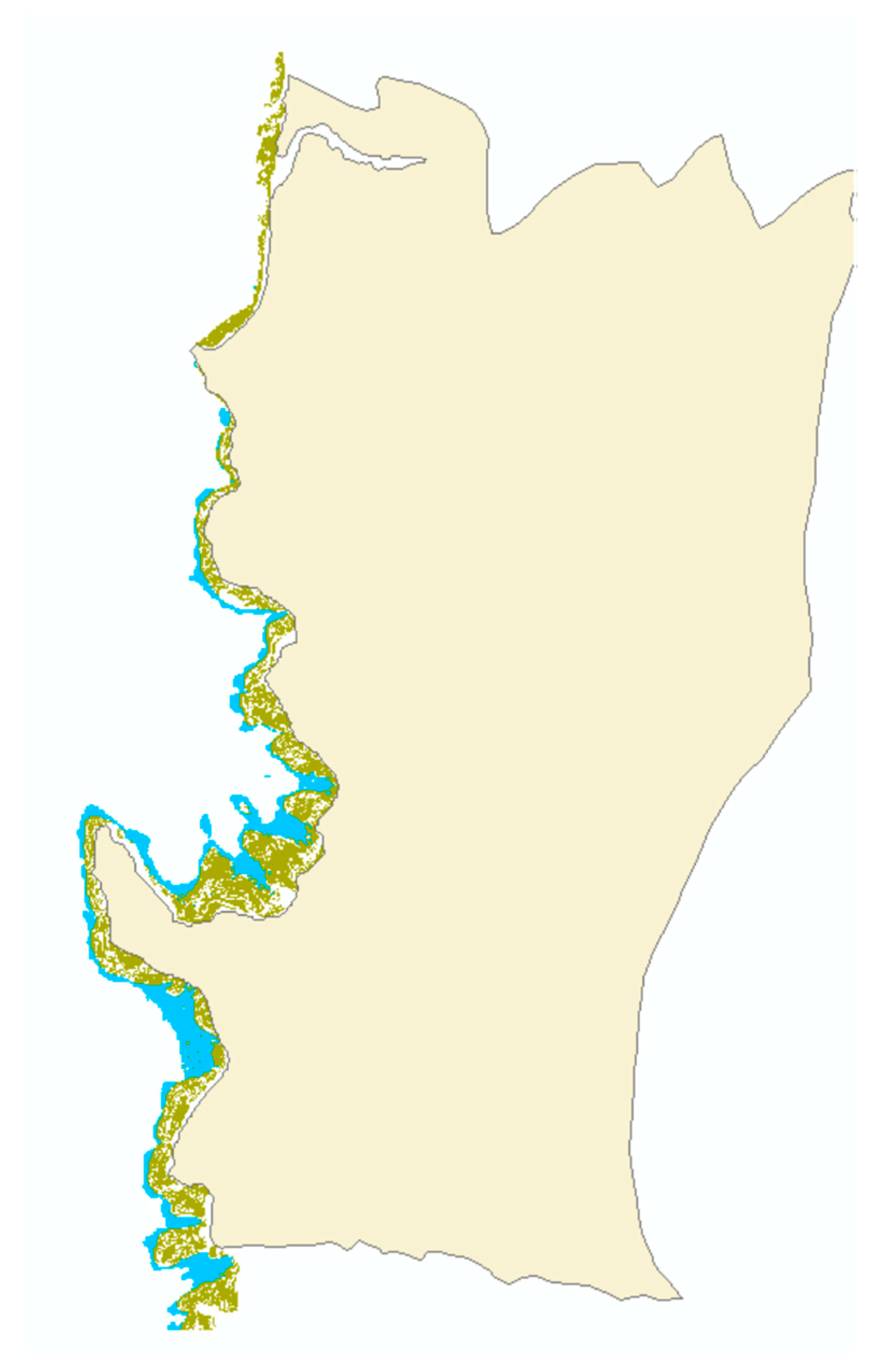
Figure 4.
Plot of bathymetric survey points. (a) Points gathered from mounted GNSS in the boat; (b) Points gathered from walking (very shallow areas).
Figure 4.
Plot of bathymetric survey points. (a) Points gathered from mounted GNSS in the boat; (b) Points gathered from walking (very shallow areas).
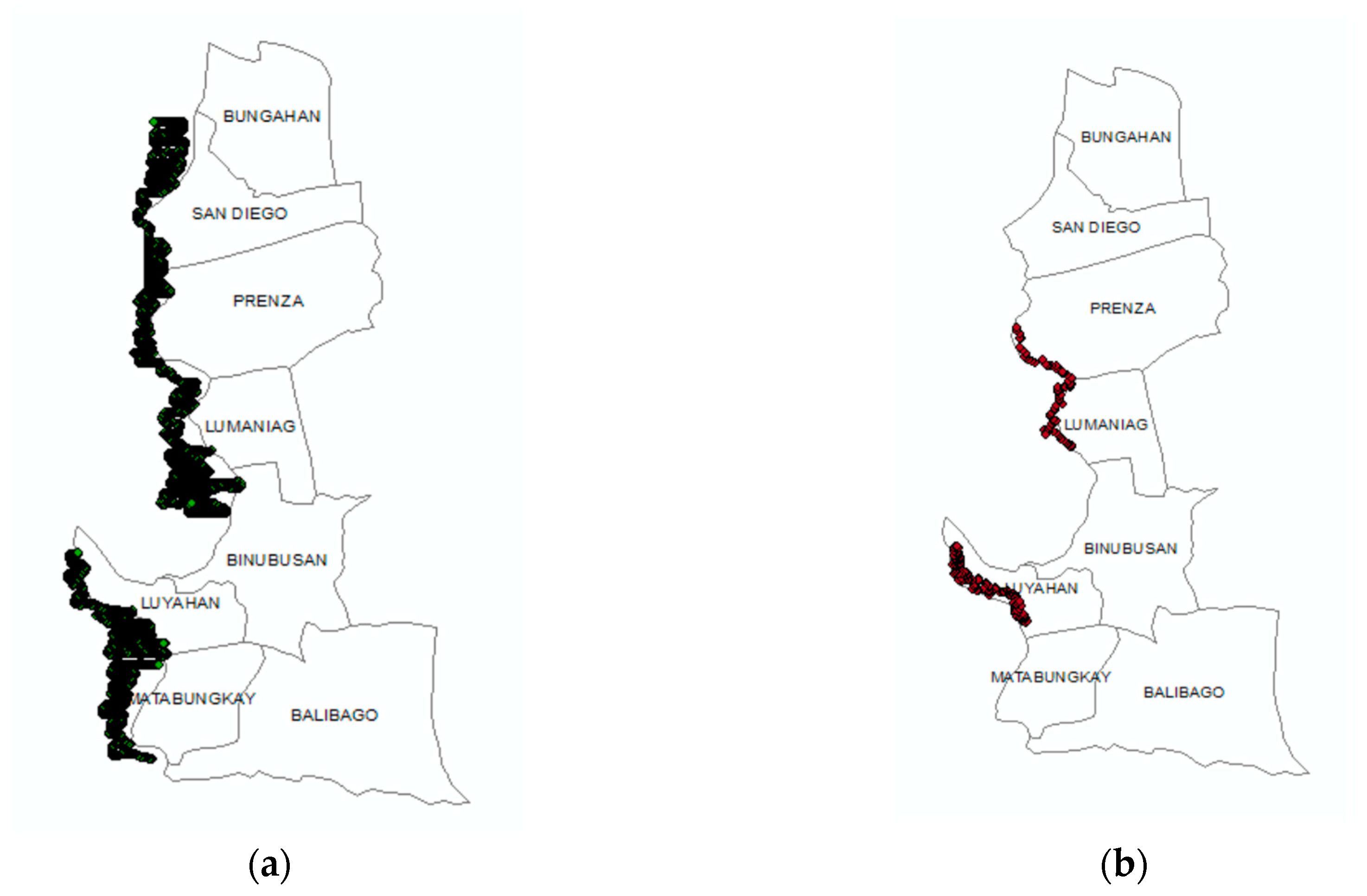
Figure 5.
Generated depth Vector using the bathymetric point by walk and boat, gray is the deepest and green is the shallowest with maximum depth of approximately 20m. (a) The generated depth before reclassification; (b) Depth reclassified.
Figure 5.
Generated depth Vector using the bathymetric point by walk and boat, gray is the deepest and green is the shallowest with maximum depth of approximately 20m. (a) The generated depth before reclassification; (b) Depth reclassified.
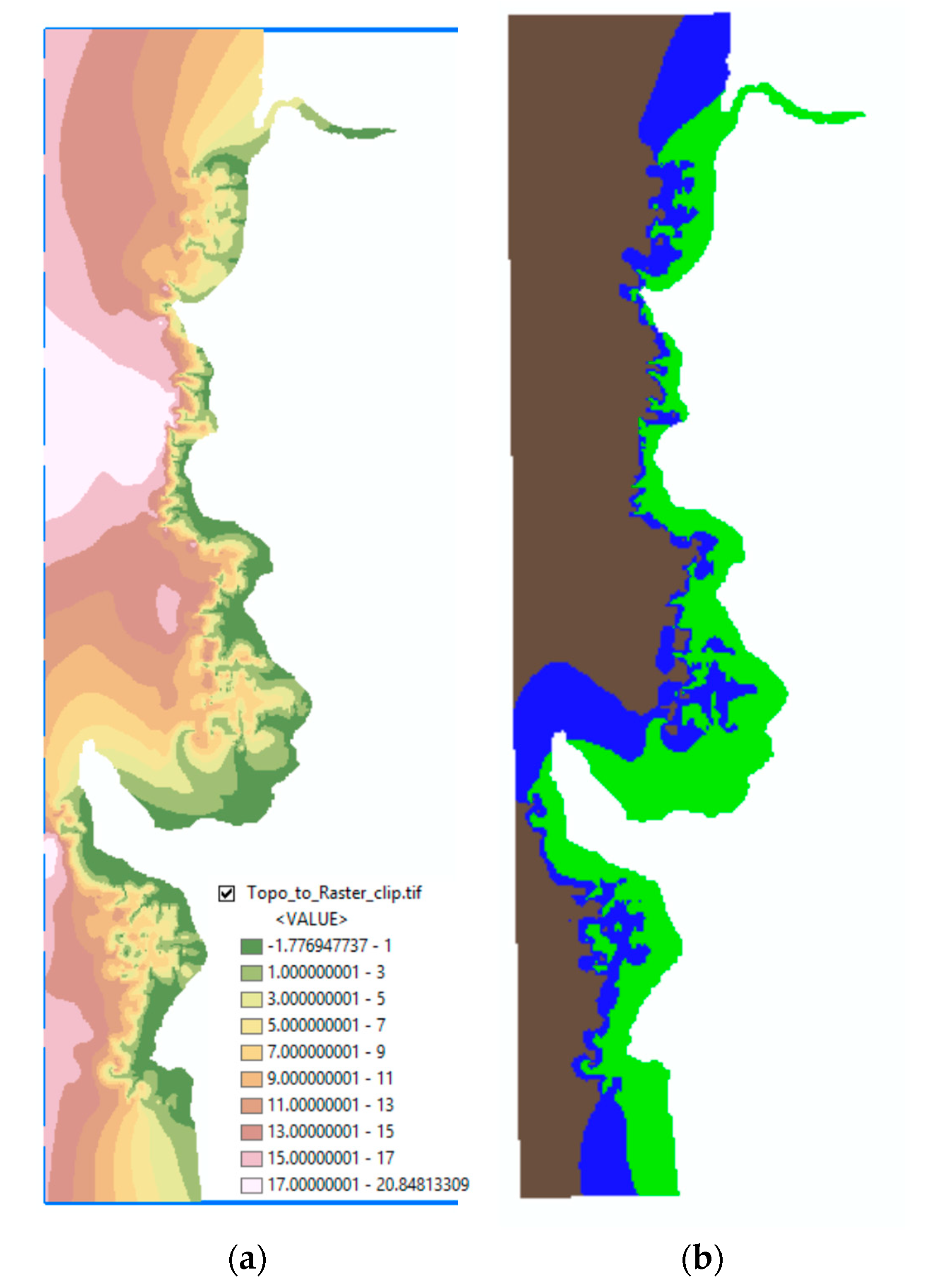
Figure 6.
The translated values of FGD and KII with the following scale; (1) very low, (2) Low, (3) Medium, (4) High, and (5) Very High: (a) Anthropogenic Disturbances scale based on the FGD in each barangay of Lian.; (b) Human Intervention and Governance scale as a criteria of Adaptive Capacity based on the FGD and KII in each barangay of Lian.; (c) Habitat Morphology scale based on the KII in Lian.
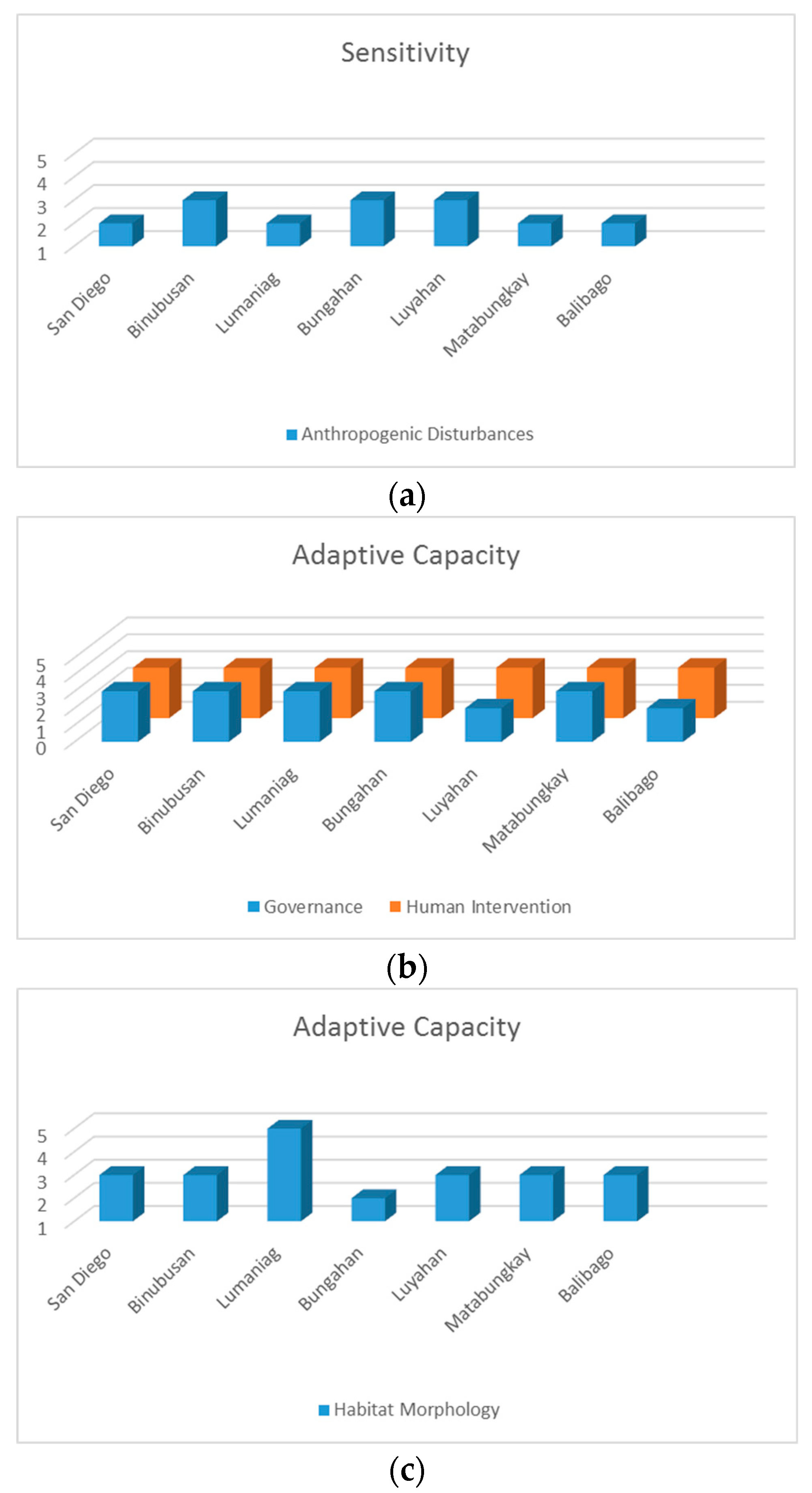
Figure 7.
Framework used as defines by IPCC, 2001.
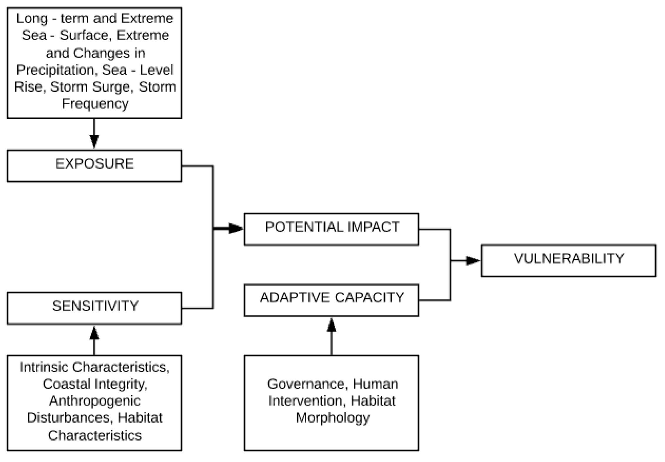
Figure 8.
Typology Analyses of the Philippine Waters UP – MSI).
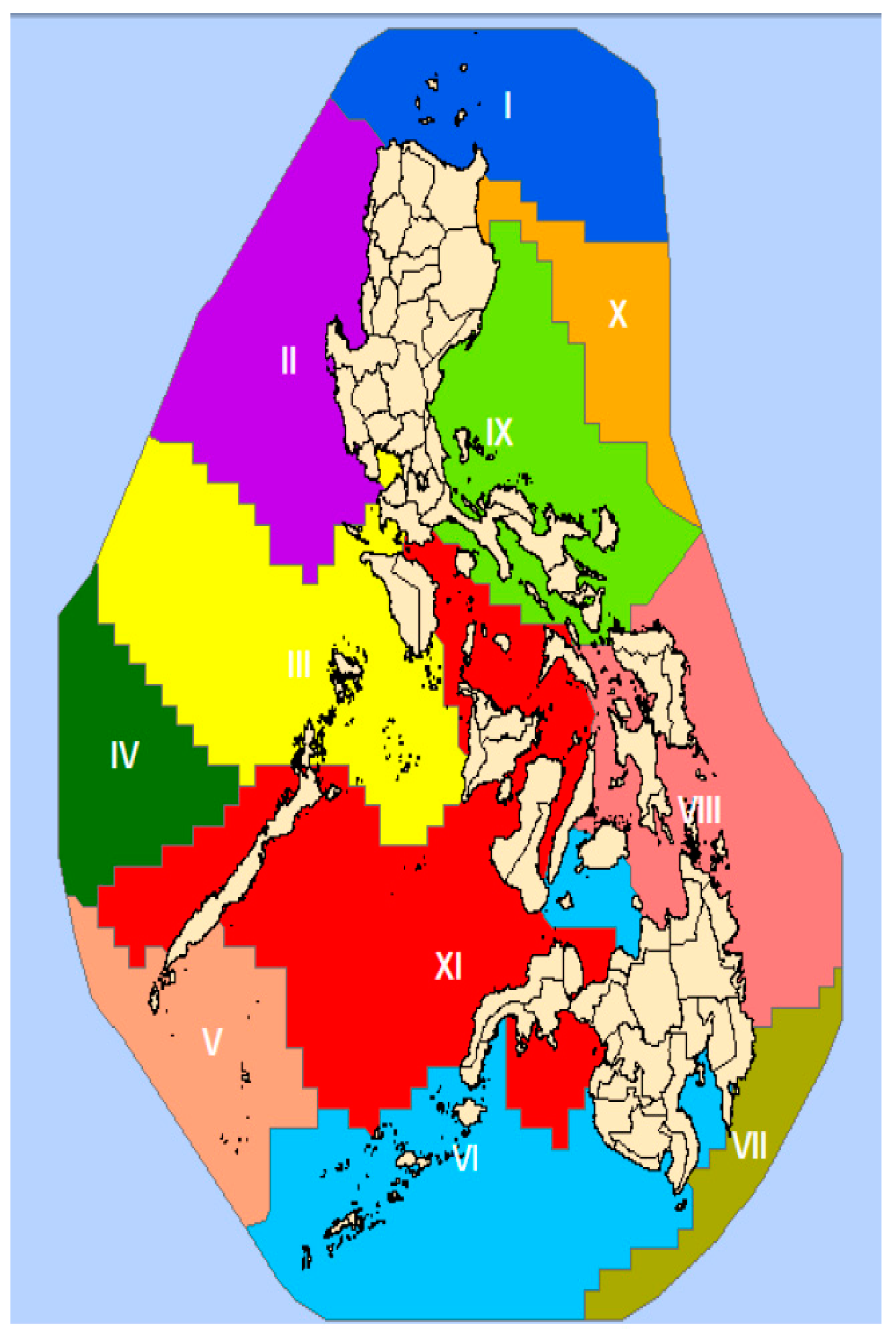
Figure 9.
Storm Surge Hazards map Advisory 4 (DOST project NOAH).
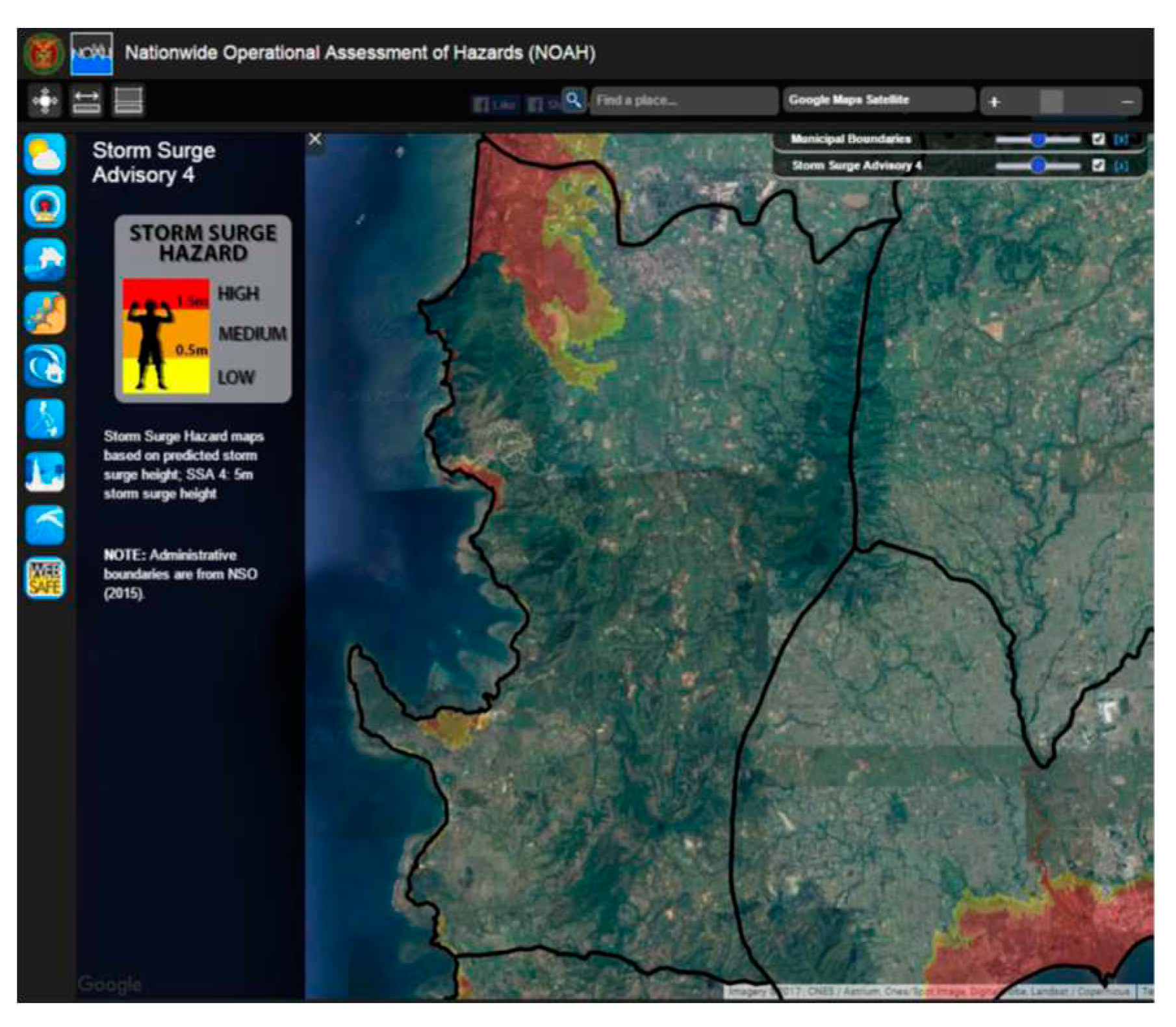
Figure 10.
Time Series of Sea Surface Temperature in the Philippines [40].
Figure 10.
Time Series of Sea Surface Temperature in the Philippines [40].
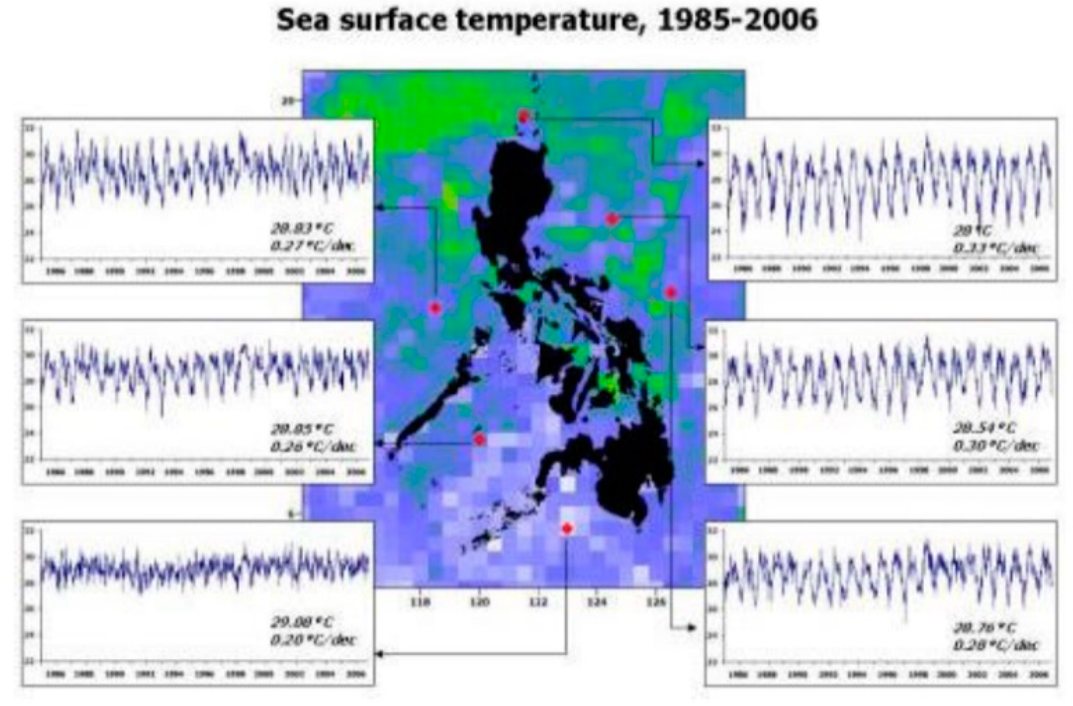
Figure 11.
Frequency of Storm passing through the Coastal of Batangas [43].
Figure 11.
Frequency of Storm passing through the Coastal of Batangas [43].
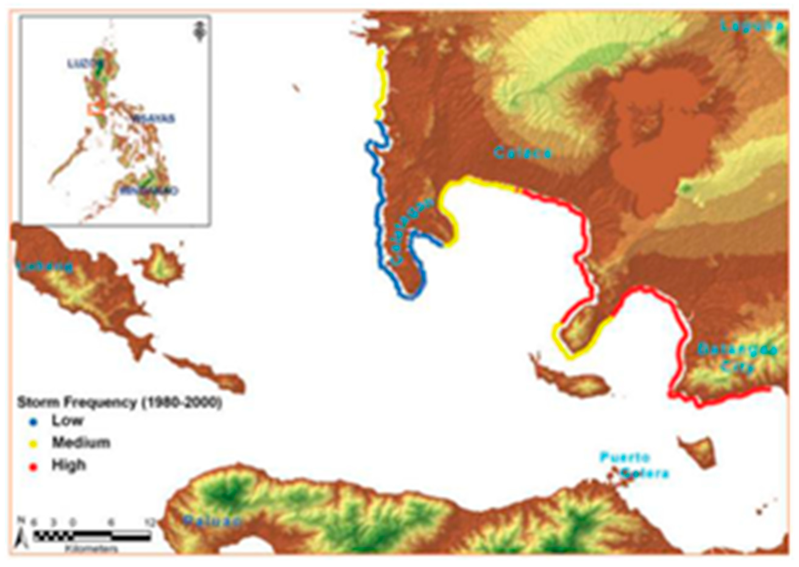
Figure 12.
(a) MPA in Lian, Batangas provided by MENRO Lian,Batngas ; (b) MPA in Lian, Batangas provided by MENRO Lian,Batngas.
Figure 12.
(a) MPA in Lian, Batangas provided by MENRO Lian,Batngas ; (b) MPA in Lian, Batangas provided by MENRO Lian,Batngas.
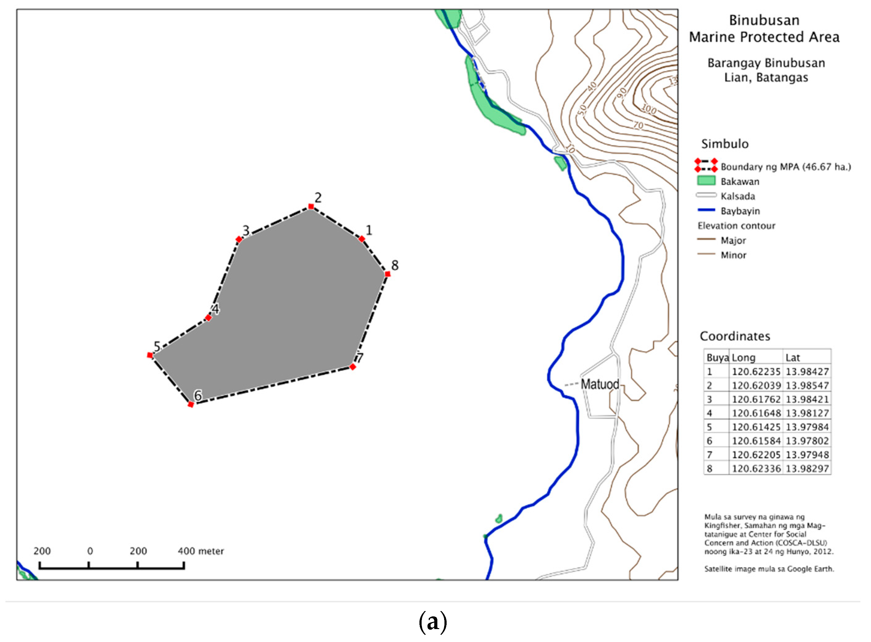
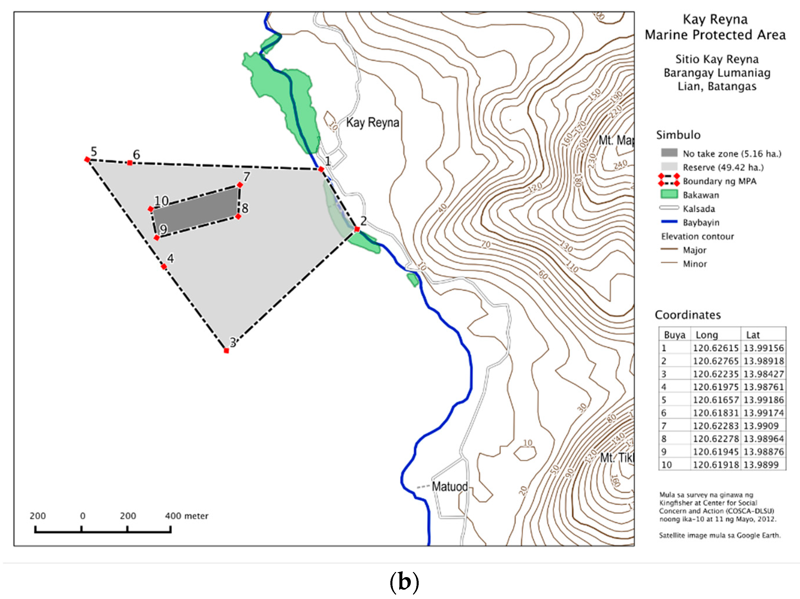
Figure 13.
Rubric of Potential Impact as a function of Sensitivity and Exposure [45].
Figure 13.
Rubric of Potential Impact as a function of Sensitivity and Exposure [45].
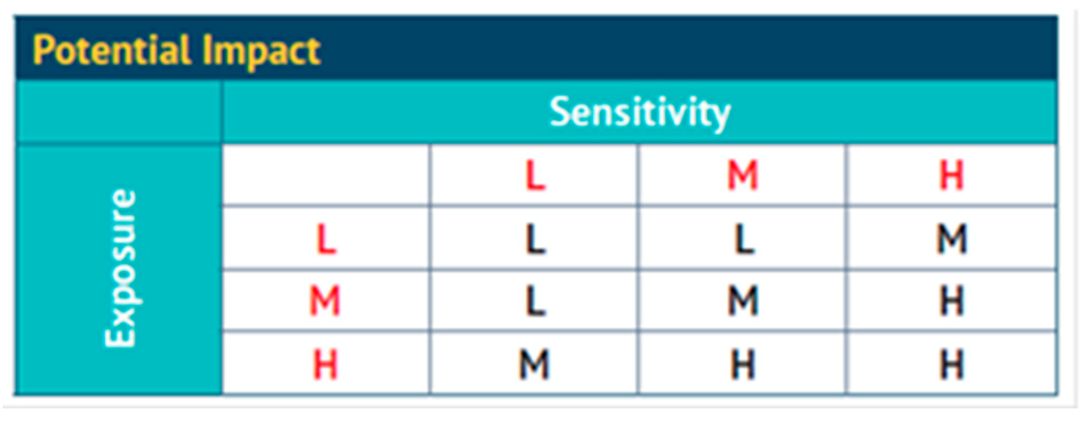
Figure 14.
Rubric of Vulnerability as a function of Adaptive Capacity and Potential Impact.
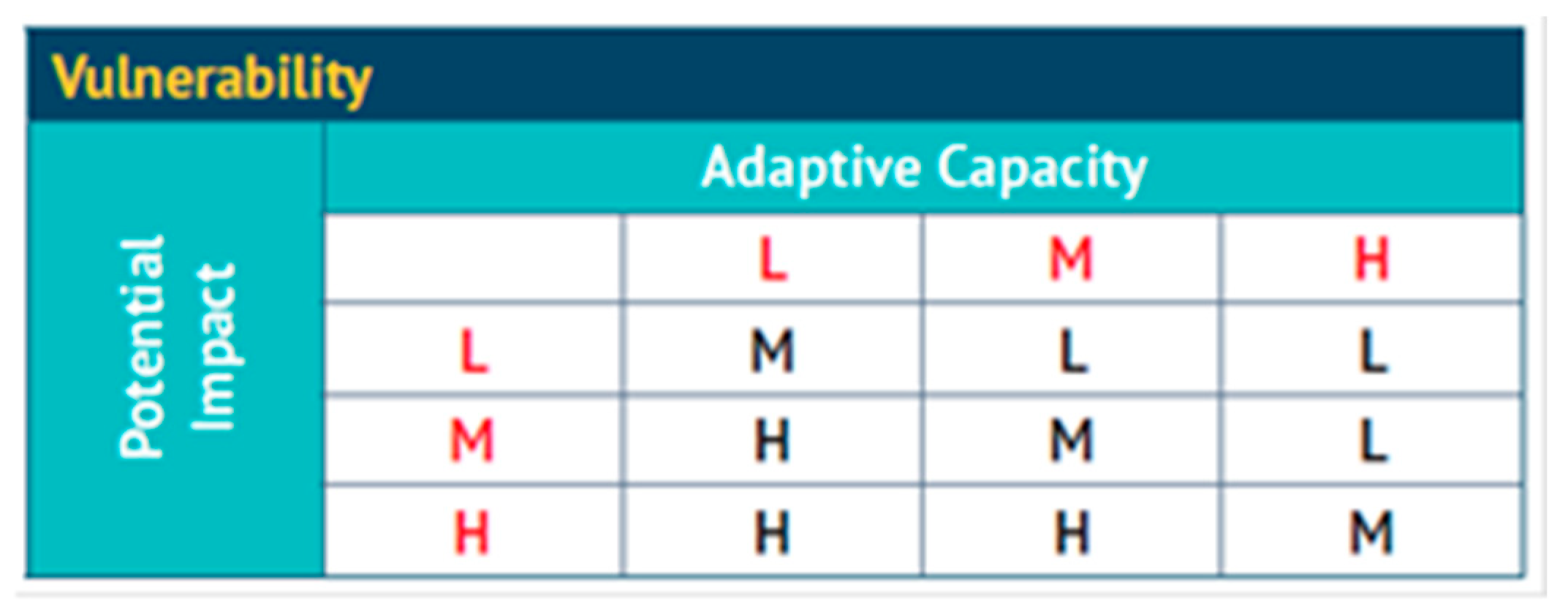
Figure 15.
Overall Vulnerability as a function of Intrinsic and Governance, Anthropogenic and Habitat Vulnerabilities [45].
Figure 15.
Overall Vulnerability as a function of Intrinsic and Governance, Anthropogenic and Habitat Vulnerabilities [45].
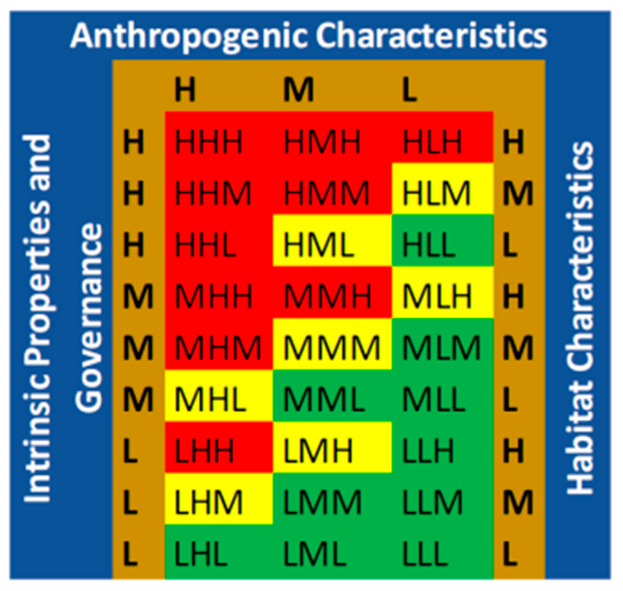
Figure 16.
Barangaya Level of Vulnerability Assessment of Mangroves to Climate Change Hazards.
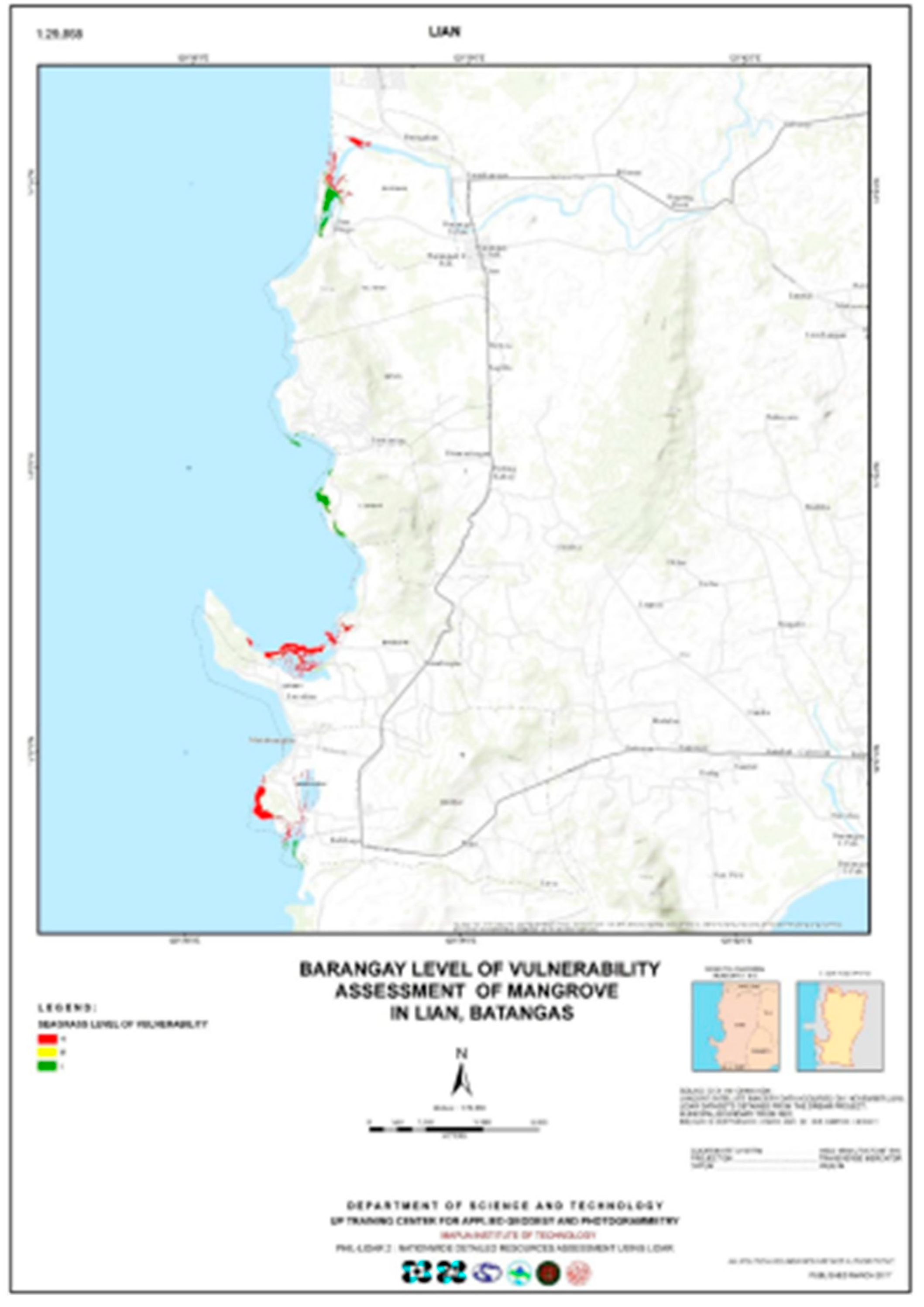
Figure 17.
Sensitivity criteria for mangroves and the score in each criteria of each barangay with (3) as High, (2) medium and (1) Low.
Figure 17.
Sensitivity criteria for mangroves and the score in each criteria of each barangay with (3) as High, (2) medium and (1) Low.
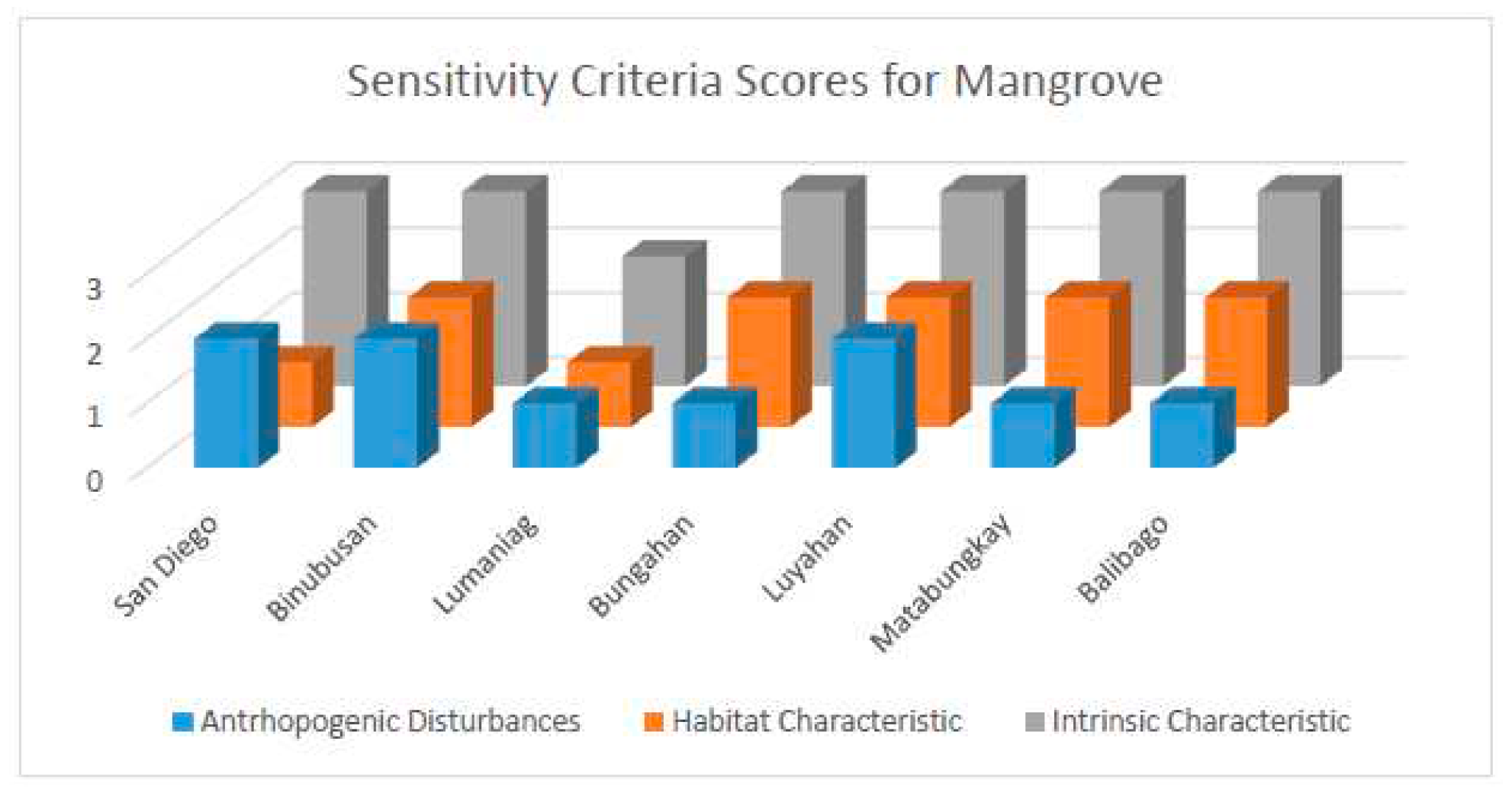
Figure 18.
Adaptive Capacity criteria for mangroves and the score in each criteria of each barangay with (3) as High, (2) medium and (1) Low.
Figure 18.
Adaptive Capacity criteria for mangroves and the score in each criteria of each barangay with (3) as High, (2) medium and (1) Low.
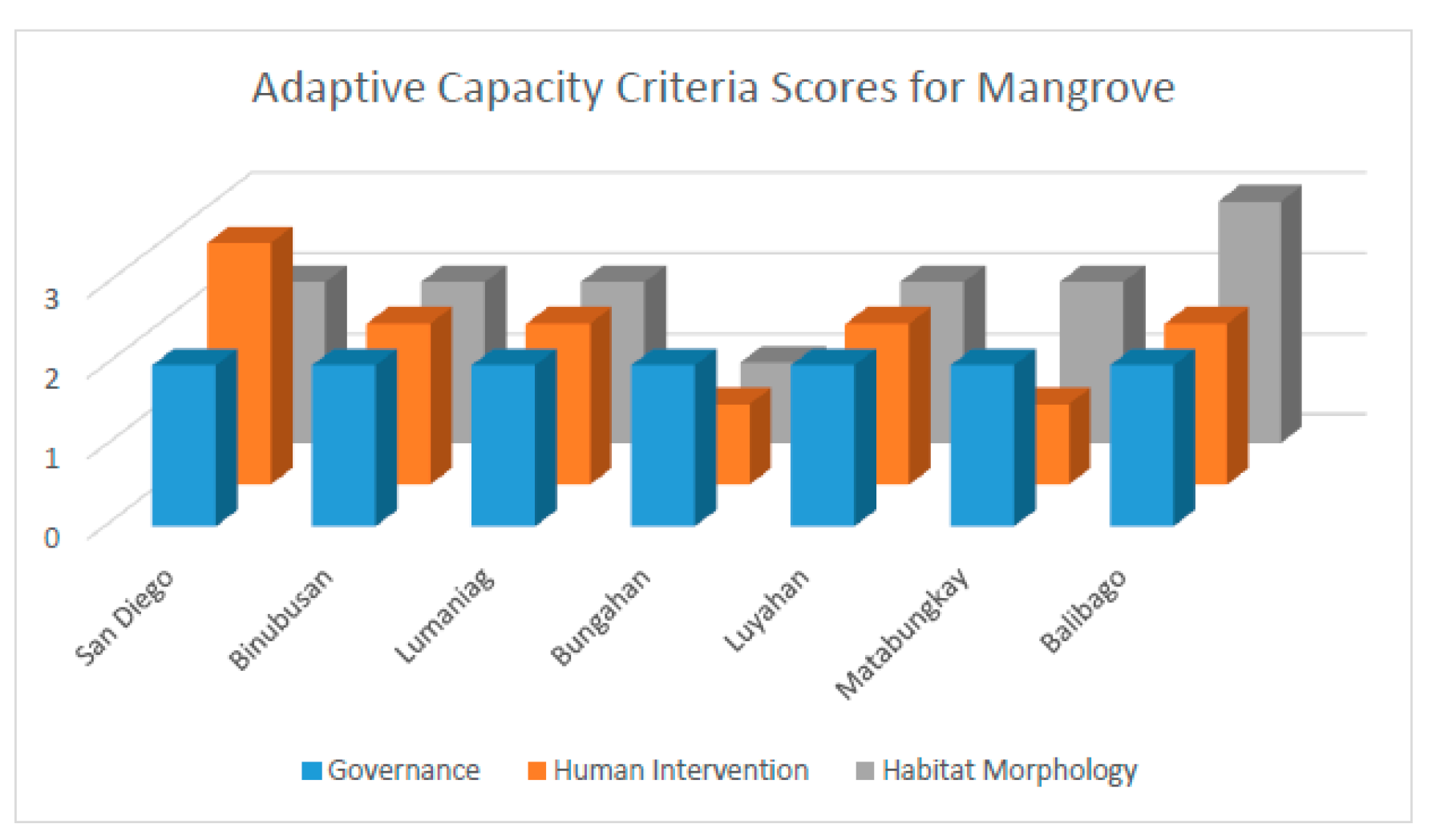
Figure 19.
Exposure scores for mangrove in each barangay of Lian; (1) Low, (2) Medium, and (3) High.
Figure 19.
Exposure scores for mangrove in each barangay of Lian; (1) Low, (2) Medium, and (3) High.
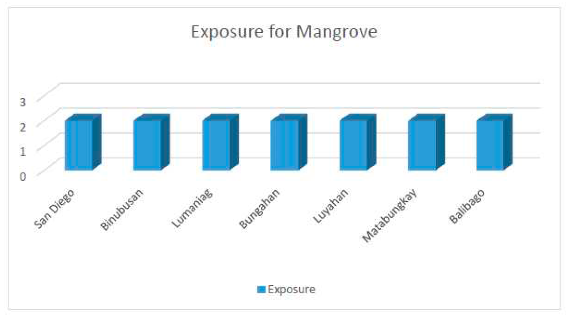
Figure 20.
Barangay Level of Vulnerability Assessment of Seagrasses.
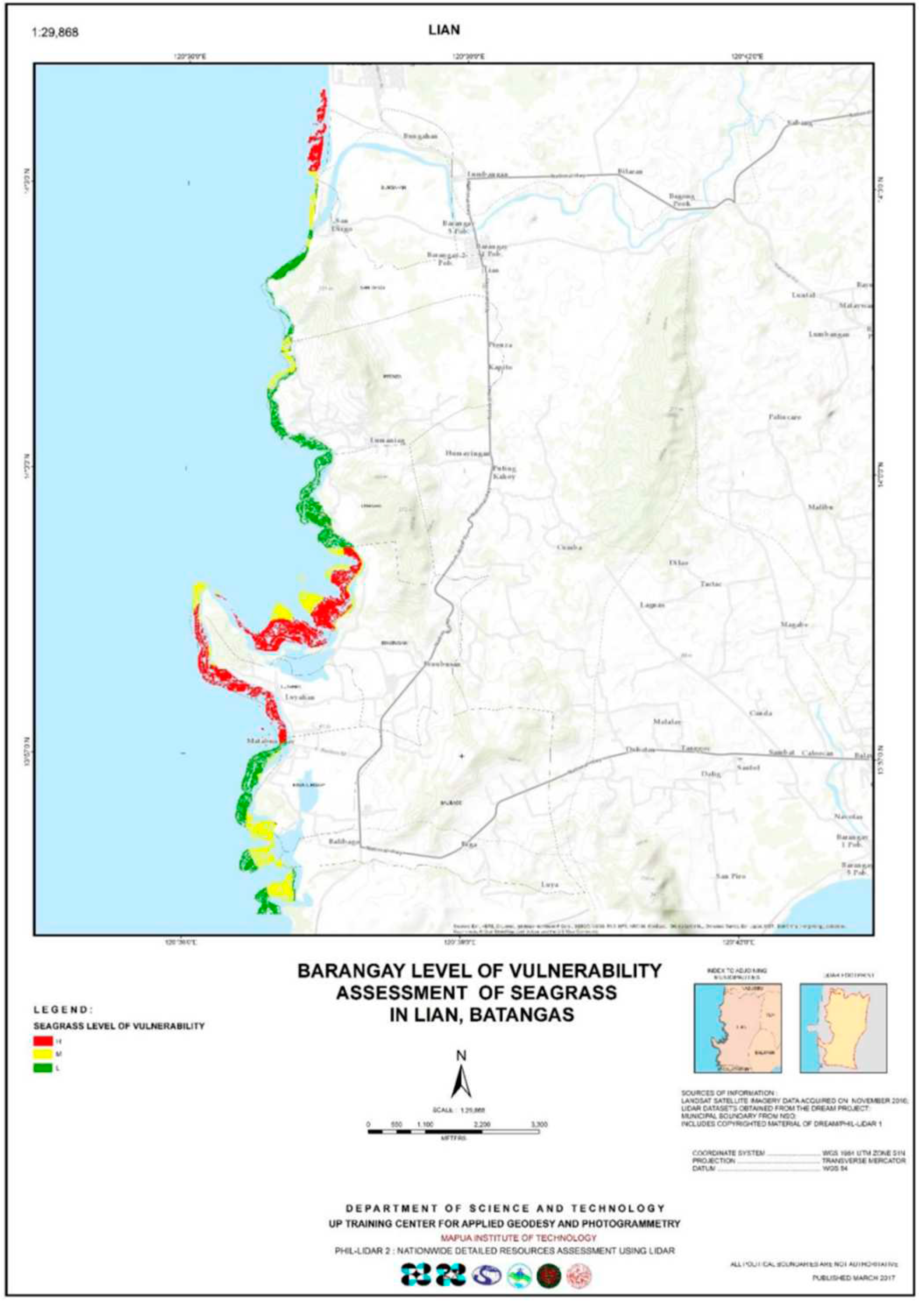
Figure 21.
Sensitivity Criteria and the scores of each criteria in each barangay for Seagrasses; (1) Low, (2) Medium, (3) High.
Figure 21.
Sensitivity Criteria and the scores of each criteria in each barangay for Seagrasses; (1) Low, (2) Medium, (3) High.
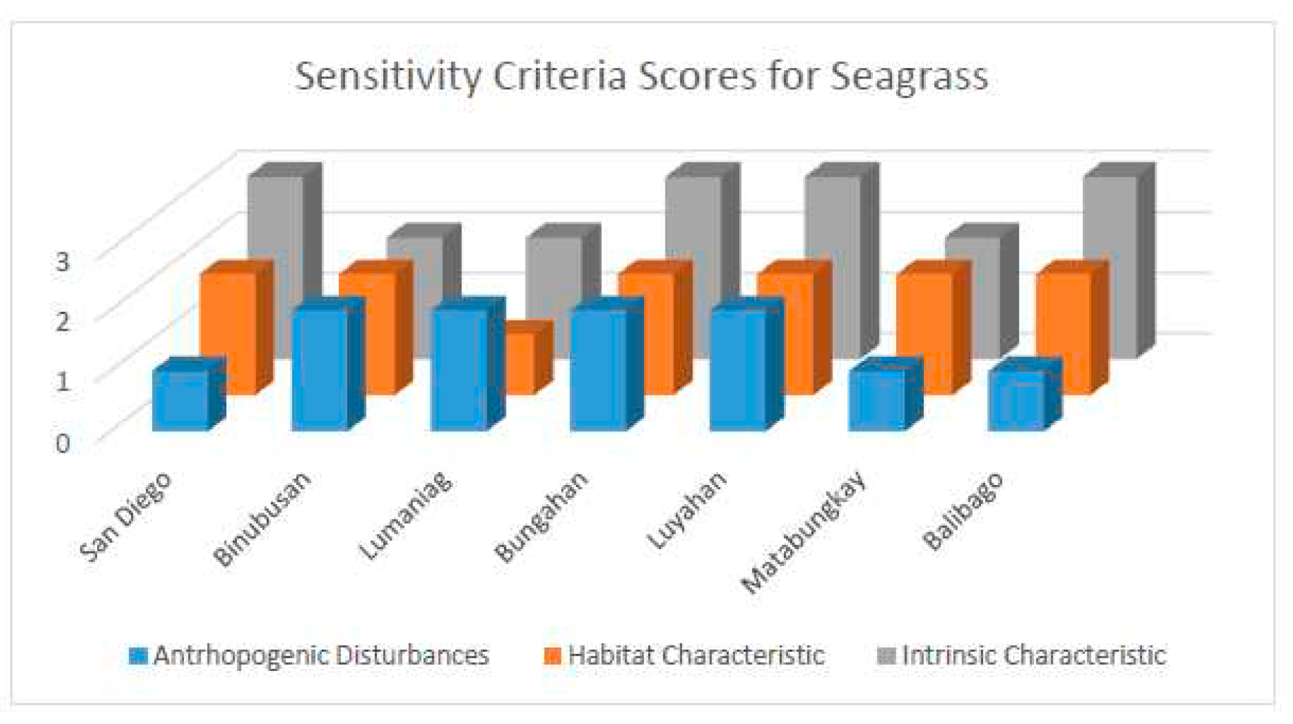
Figure 22.
Adaptive cspscity Criteria and the scores of each criteria in each barangay for Seagrasses; (1) Low, (2) Medium, (3) High.
Figure 22.
Adaptive cspscity Criteria and the scores of each criteria in each barangay for Seagrasses; (1) Low, (2) Medium, (3) High.
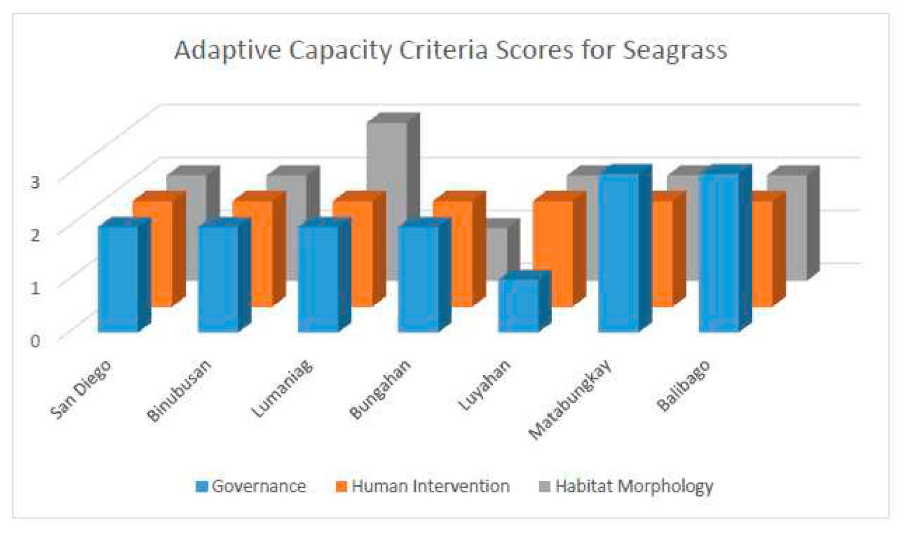
Figure 23.
Exposure scores for seagrass in each barangay of Lian; (1) Low, (2) Medium, and (3) High.
Figure 23.
Exposure scores for seagrass in each barangay of Lian; (1) Low, (2) Medium, and (3) High.
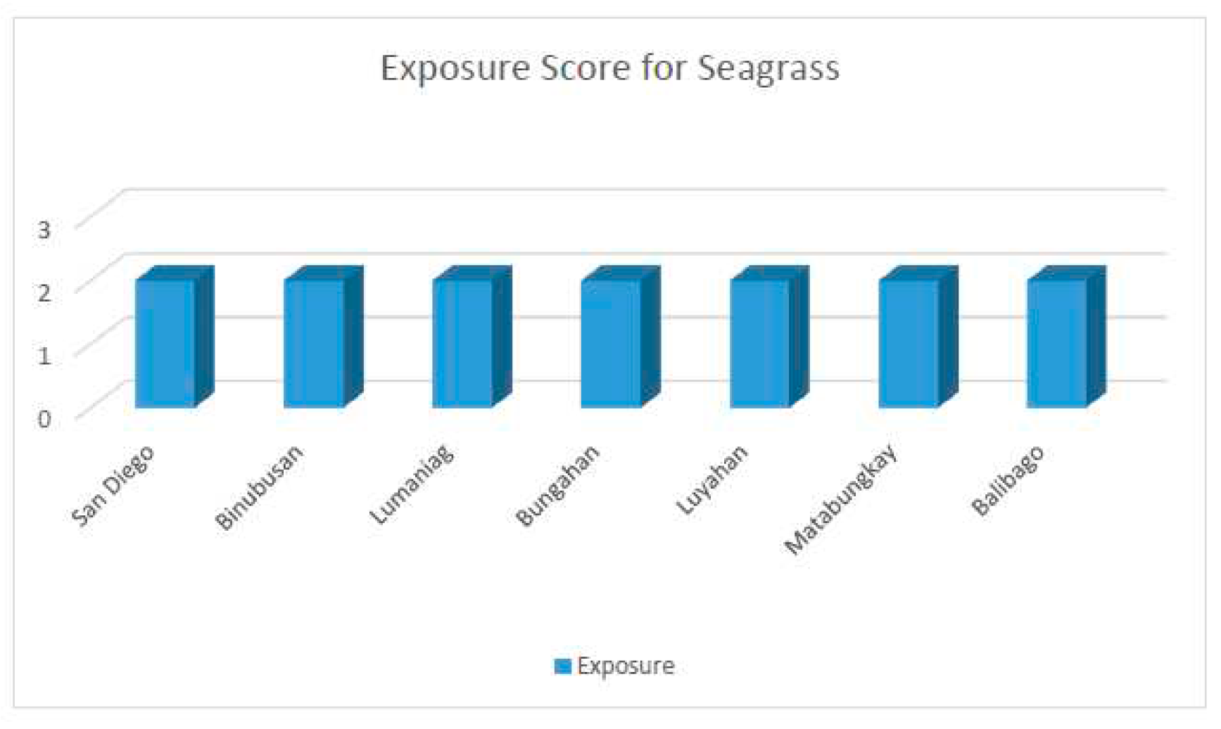
Figure 24.
Barangay Level of Vulnerability Assessment of Corals.
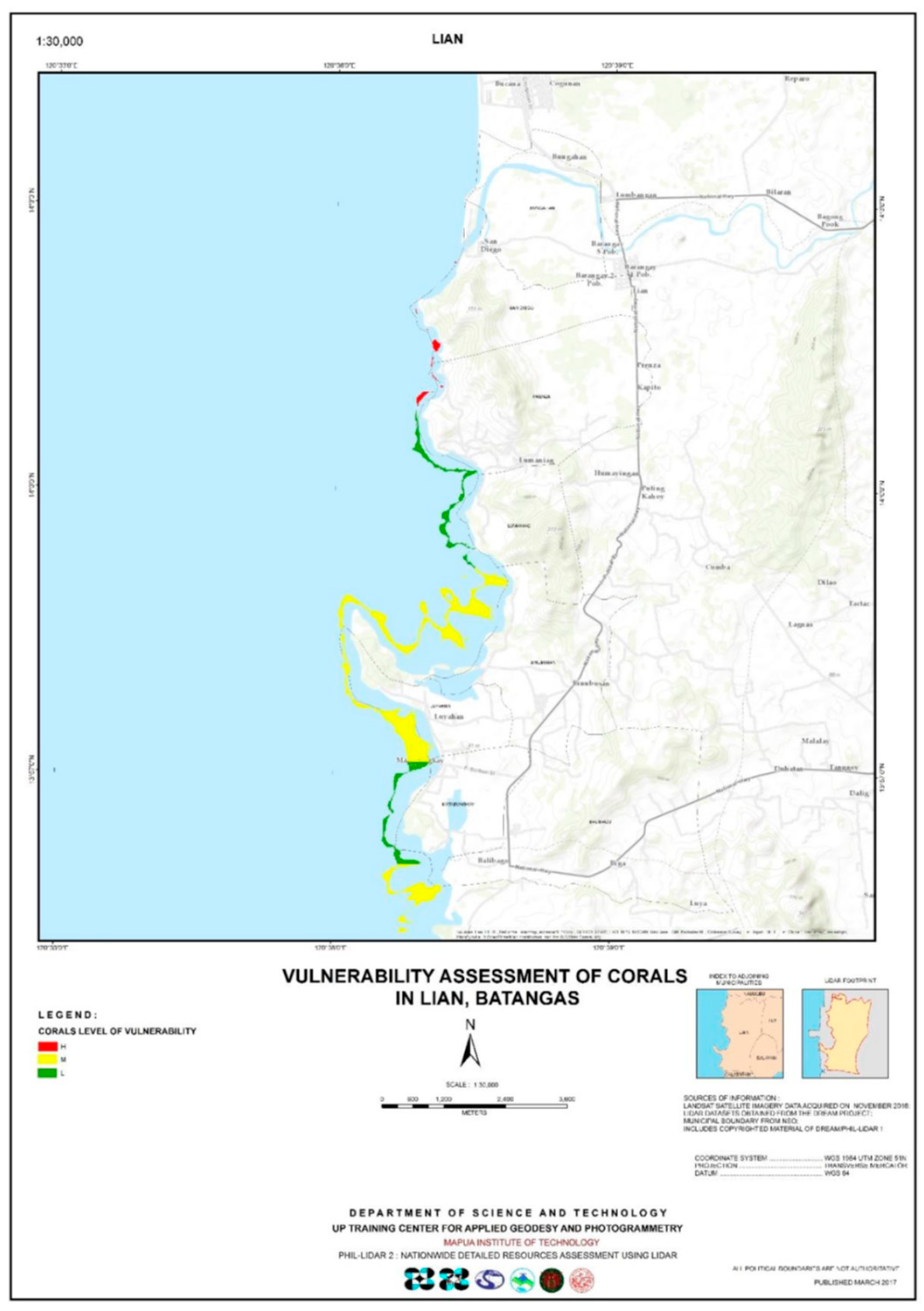
Figure 25.
Sensitivity Criteria and the scores of each criteria in each barangay for corals; (1) Low, (2) Medium, (3) High.
Figure 25.
Sensitivity Criteria and the scores of each criteria in each barangay for corals; (1) Low, (2) Medium, (3) High.
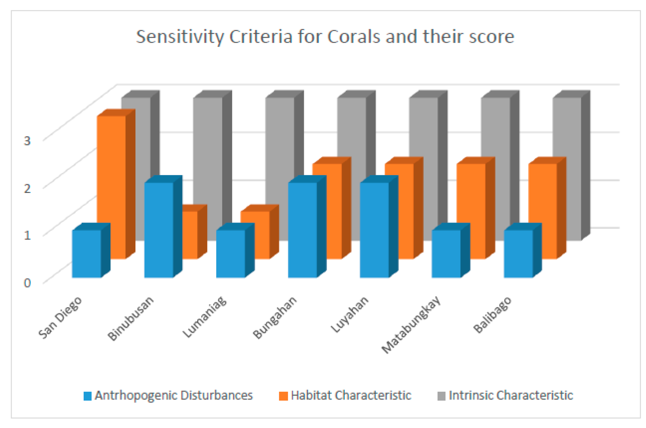
Figure 26.
Adaptive Capacity and the scores of each criteria in each arangay for corals; (1) Low, (2) Medium, (3) High.
Figure 26.
Adaptive Capacity and the scores of each criteria in each arangay for corals; (1) Low, (2) Medium, (3) High.
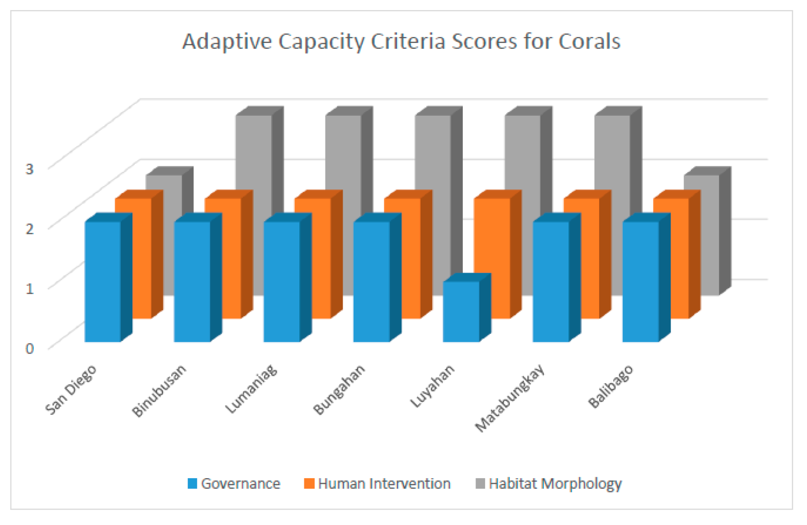
Figure 27.
Exposure and the scores of each criteria in each arangay for corals; (1) Low, (2) Medium, (3) High.
Figure 27.
Exposure and the scores of each criteria in each arangay for corals; (1) Low, (2) Medium, (3) High.
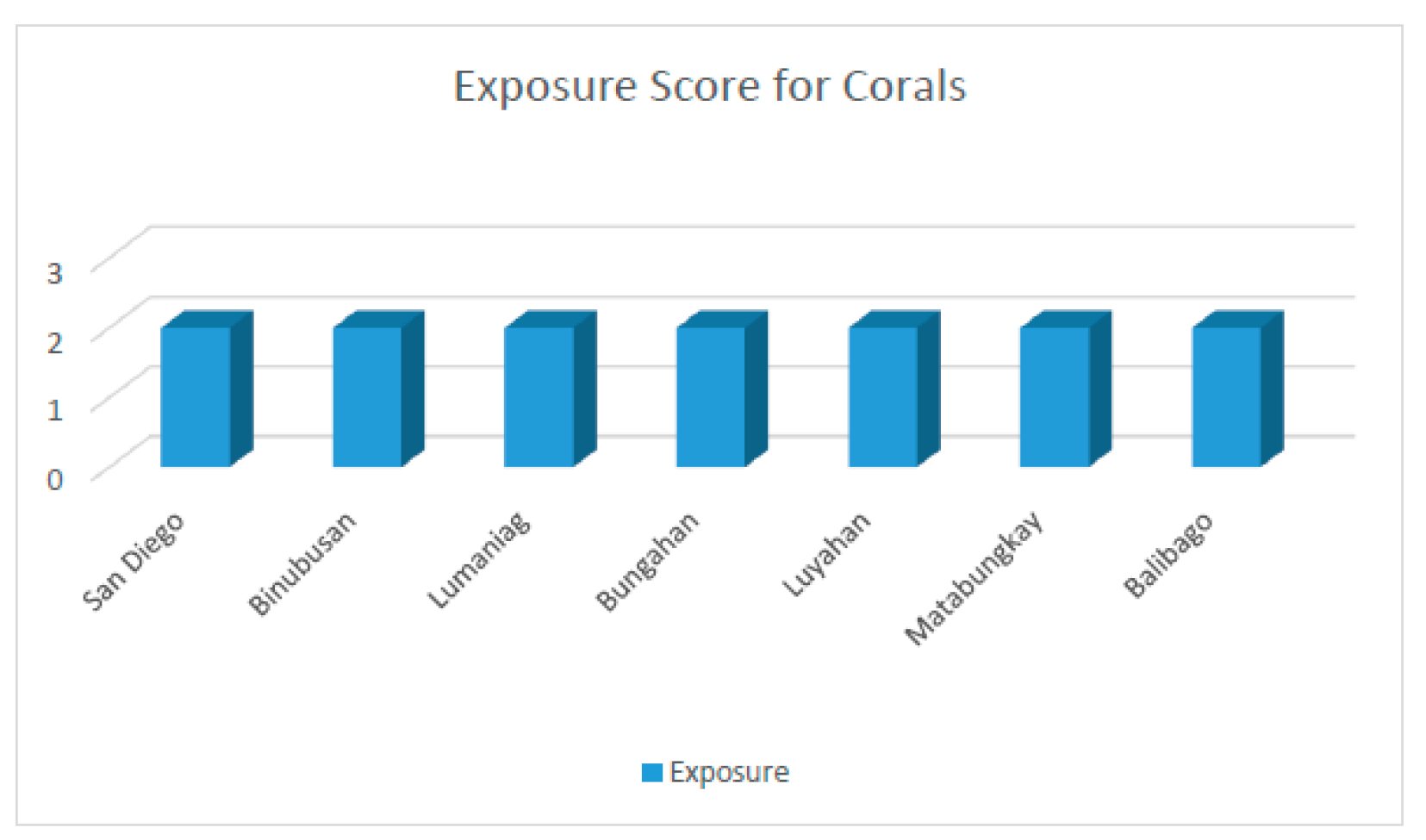
Figure 28.
Graph of the summary of VA results of mangroves, seagrass, and corals.
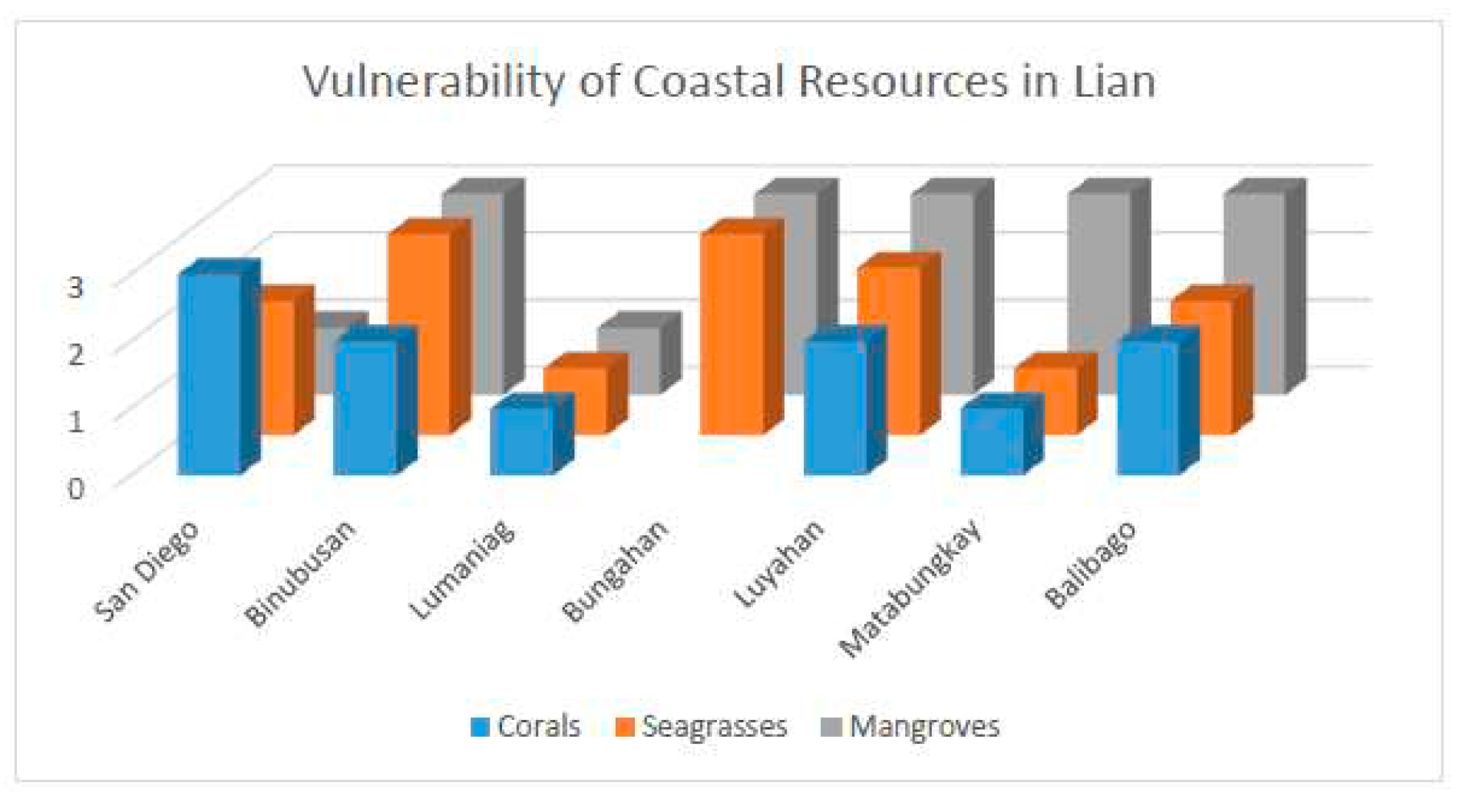
Table 1.
Additional Data Used.
| Additional Data | Provider/Source |
|---|---|
| CLUP | LGU |
| Population, Population Density | LGU, NSO |
| Fishermen’s Organization | LGU, MAO |
| MPA Maps | LGU, MENRO |
| Seagrasses Map (used for verification) | DENR |
Table 2.
Seagrasses and Corals Sensitivity for Depth.
| Depth (meters) | Rating | Numerical Rating |
|---|---|---|
| 0 – 10 | Very High | 5 |
| 5 – 10 | High | 4 |
| 10 – 30 | Moderate | 3 |
| 30 – 60 | Low | 2 |
| >60 | Very Low | 1 |
Table 3.
Scores for the Cluster III, 5 (very high), 4 (high), 3 (Medium), 2 (Low), and 1 (Very Low).
Table 3.
Scores for the Cluster III, 5 (very high), 4 (high), 3 (Medium), 2 (Low), and 1 (Very Low).
| Exposure | Numerical Rating |
|---|---|
| IOT | 2 |
| EHE | 4 |
| ER | 1 |
| DWB | 5 |
| SLR | 5 |
| Average | 3.4 |
Table 5.
Proximity to Coastal Development Scores Criteria (Mangroves).
| Distance to Urban Areas (meters) | Rating | Numerical Rating |
|---|---|---|
| Within 500 | Very High | 5 |
| 501- 1000 | High | 4 |
| 1001 - 1500 | Moderate | 3 |
| 1501 - 2000 | Low | 2 |
| Beyond 2000 | Very Low | 1 |
Table 6.
Proximity to Coastal Development Scores Criteria (Seagrasses).
| Distance to Urban Areas (meters) | Rating | Numerical Rating |
|---|---|---|
| Within 300 | Very High | 5 |
| 301- 600 | High | 4 |
| 601 - 900 | Moderate | 3 |
| 901 - 1200 | Low | 2 |
| Beyond 1200 | Very Low | 1 |
Table 7.
Proximity to Aquaculture Scores Criteria (Mangroves).
| Distance to Aquaculture Areas (meters) | Rating | Numerical Rating |
|---|---|---|
| Within 750 | Very High | 5 |
| 751 - 1500 | High | 4 |
| 1501 - 2250 | Moderate | 3 |
| 2251 - 3000 | Low | 2 |
| Beyond 3000 | Very Low | 1 |
Table 8.
Proximity to Aquaculture Scores Criteria (Seagrasses).
| Distance to Aquaculture Areas (meters) | Rating | Numerical Rating |
|---|---|---|
| Within 300 | Very High | 5 |
| 301 - 600 | High | 4 |
| 601 - 900 | Moderate | 3 |
| 901 - 1200 | Low | 2 |
| Beyond 1200 | Very Low | 1 |
Table 9.
Proximity to Aquaculture Scores Criteria (Seagrasses).
| Distance to Aquaculture Areas (meters) | Rating | Numerical Rating |
|---|---|---|
| Within 500 | Very High | 5 |
| 501 - 1000 | High | 4 |
| 1001 - 1500 | Moderate | 3 |
| 1501 - 2000 | Low | 2 |
| Beyond 2000 | Very Low | 1 |
Table 10.
Seagrasses and Corals Depth sensitivity Scores criteria.
| Distance to Aquaculture Areas (meters) | Rating | Numerical Rating |
|---|---|---|
| 0 - 5 | Very High | 5 |
| 5 - 10 | High | 4 |
| 10 - 30 | Moderate | 3 |
| 30 - 60 | Low | 2 |
| Greater than 60 | Very Low | 1 |
Table 11.
Seagrasses Depth sensitivity Scores criteria.
| Distance to Aquaculture Areas (meters) | Rating | Numerical Rating |
|---|---|---|
| Within MPA | High | 4 |
| Within 50 meters of the MPA | Moderate | 3 |
| Beyond 50 meters of MPA | Low | 2 |
Table 12.
Proximity to Coastal Development Scores Criteria (Corals).
| Distance to Urban Areas (meters) | Rating | Numerical Rating |
|---|---|---|
| Within 1000 | Very High | 5 |
| 1001 - 2000 | High | 4 |
| 2001 - 3000 | Moderate | 3 |
| 3001 - 4000 | Low | 2 |
| Beyond 4000 | Very Low | 1 |
Table 13.
Proximity to Aquaculture Scores Criteria (Corals).
| Distance to Aquaculture Areas (meters) | Rating | Numerical Rating |
|---|---|---|
| Within 1250 | Very High | 5 |
| 1251 - 2500 | High | 4 |
| 2501 - 3750 | Moderate | 3 |
| 3751 - 5000 | Low | 2 |
| Beyond 5000 | Very Low | 1 |
Table 14.
Proximity to River Outlets Scores Criteria (Corals).
| Distance to River Outlet Areas (meters) | Rating | Numerical Rating |
|---|---|---|
| Within 750 | Very High | 5 |
| 751 - 1500 | High | 4 |
| 1501 - 2250 | Moderate | 3 |
| 2251 - 3000 | Low | 2 |
| Beyond 3000 | Very Low | 1 |
Disclaimer/Publisher’s Note: The statements, opinions and data contained in all publications are solely those of the individual author(s) and contributor(s) and not of MDPI and/or the editor(s). MDPI and/or the editor(s) disclaim responsibility for any injury to people or property resulting from any ideas, methods, instructions or products referred to in the content. |
© 2023 by the authors. Licensee MDPI, Basel, Switzerland. This article is an open access article distributed under the terms and conditions of the Creative Commons Attribution (CC BY) license (http://creativecommons.org/licenses/by/4.0/).
Copyright: This open access article is published under a Creative Commons CC BY 4.0 license, which permit the free download, distribution, and reuse, provided that the author and preprint are cited in any reuse.


