

Submitted:
31 October 2023
Posted:
02 November 2023
You are already at the latest version
Abstract
Flood disasters have become an annual occurrence along the East Coast of North Sumatra (ECNS) and Medan City. Numerous studies have examined the causal factors flood disasters in this area, such as changes in land use, drainage issues, and population growth, but the intensity of flood disasters continues to rise. In this research, we focused on evaluating the unexplored factors of land subsidence and rising sea levels in this region. Our investigation uses multi-sensor satellite data and field surveys to conduct an assessment of the rate of land subsidence and sea level rise and assess their implications on flood disasters. This study highlights the potential of multi-sensor satellite data as a primary resource for assessing flood disasters in coastal areas and densely populated large cities. Furthermore, we propose a solution to reduce the negative impact of flood disasters by by engaging local communities and environmental enthusiasts in mangrove reforestation along the coastline.
Keywords:
disaster
; flood
; satellite sensor
; sea level rise
; land subsidence
1. Introduction
Medan City, the capital city of North Sumatra Province, has a population of 2.4 million people with an area of 26,510 ha, or 3.6% of the total area. North Sumatra Province is the fifth-most populous city and the third-largest city in Indonesia. Starting from Belawan City, located on the east coast of North Sumatra and north of Medan, it is a sloping lowland. It is the confluence of two rivers, the Deli and Babura, which flow into Belawan beach. Flooding tends to occur during heavy rainfall, and getting worse at high tide.
Every year, flood disasters occurs during the rainy season and inundate areas reaching up to 9000 ha. The flood disaster in Medan City is caused by excessive water from upstream rivers and poor urban drainage conditions [1,2,3]. A 40-year dataset clearly shows that Medan City and its surroundings experience the most frequent and intense flood disasters. The peak incidents typically occur in December and January, during periods of high rainfall exceeding 50 mm/day [4]. Geospatial analysis highlights that 61% of Medan City indicates a high to very high vulnerability to these recurring floods [2]. Flood data in Medan City shows that flood events affected 3,128 housing units and 13,287 residents and caused material losses approximately US$4,170,800 [3]. Until now, Medan City has been experiencing flooding. So far, the flood control projects implemented have not been successful [5].
There is a need for an assessment of the factors causing flooding to provide essential insights for the government policy formulation aimed at effectively mitigating flooding challenges. Several studies have been conducted to analyze the causal factors of flooding in Medan city and its surroundings, such as poorly performing urban drainage system that is unable to compensate for the increase in runoff discharge, garbage blocking the drainage, changes in land use, and erosion [5,6,7]. Beyond these factors, sea level rise and land subsidence also affect flooding conditions [8,9]; even 5-10 cm of sea level rise affects the doubling of flooding in tropical areas [10,11,12]. However, until now, the impact of sea level rise and land subsidence on floods in Medan and its surroundings is not well understood.
A number of studies shows the critical connection between land subsidence and the exacerbation of flooding events, especially in big cities in Indonesia such as Bandung [13], Jakarta [14], and Semarang [15]. Land subsidence tends to occur in urban areas where a very large proportion of the population rely on wells for water supply, making them vulnerable to land subsidence. However, land subsidence has not generally been considered in studies of flood hazards and mitigation efforts, as research data on the rate of land subsidence is still rare.
Some scientists have developed several methods to estimate the land subsidence rate from radar data, for instance, the Differential Interferometric Synthetic Aperture Radar (DInSAR) method. DInSAR interferometry is a useful technique for detecting and monitoring deformation movements, as well as for advancing research [16]. The DinSAR approach can be used to determine changes in the volume deformation of the soil surface [13,15,17,18]. The satellite-derived estimations of subsidence depth are compared to the previous results of GPS survey [19].
Differential synthetic aperture radar interferometry (DInSAR) is an effective method for detecting ground displacement or land deformation in the antenna line-of-sight (slant-range) direction using synthetic aperture radar (SAR) data acquired at two different times [20,21,22,23]. The D-InSAR method complements ground-based methods such as levelling and GPS measurements by providing information across a large coverage area even when the location is inaccessible [24].
Data from the Sentile 1A satellite radar, available free of charge, is a great source of data for processing and analysis to produce land subsidence maps. Several studies show that flood conditions in Medan City and its surroundings are getting worse due to several factors, such as changes in land use, deforestation in upstream areas, and increasing population by 0.26% [3]. However, no study has yet examined the impact of land subsidence on the risk of flooding in the ECNS and Medan City. To better predict and mitigate flooding on the ECNS, we need accurate information about the factors that contribute to flooding and its impacts. This study aims to use DInSAR method, a technique that analyzes Sentinel 1-A radar satellite images, to measure the rate of land subsidence and altimetry data to analyzed the sea level rise trends on the ECNS. This information can then be used to develop more accurate flood models and to identify areas that are at risk of flooding.
2. Materials and Methods
The study site is located on the east coast of North Sumatra, including Medan, which is located at a geographical position of 03°39'00”S - 98º38'00”E to 03°53'00”S - 98º58'00” E. Medan City and the ECNS covers 265 square kilometers and has 21 subdistricts (Figure 1). The study area is growing rapidly, as evidenced by the expansion of settlements and the physical development of the city area. The increase in population [25] and development has led to the conversion of vegetated land for other purposes, such as economic areas and settlements.
2.1. Multi-Sensor Satellite Data
This study used used multi-sensor satellite data and field survey measurements. Altimetry data from multiple satellites was used to measure changes in sea level over time and analyze the trends (https://ccar.colorado.edu/altimetry/). Synthetic Aperture Radar (SAR) data from the Sentinel-1 satellite is used to measure land deformation (https://asf.alaska.edu/). SAR Sentinel-1A Level 1 Single Look Complex (SLC) imagery and Digital Elevation Model (DEM) data are used to estimate the rate of land subsidence. Optical data from the Sentinel-2 satellite sensor is used to identify land use (https://www.satimagingcorp.com/satellite-sensors/other-satellite-sensors/sentinel-2a/).
SAR image data processing with the DinSAR method using the calculation of the phase difference of two or more SAR images in the SeNtinel Application Platform (SNAP) software (Ullo 2019). DInSAR aims to extract the total phase caused by deforming/changing ground values by eliminating or reducing other factors that contribute to the formation of phase interferograms. The DInSAR technique allows the terrain displacement to be calculated as the interferometric phase contains the following phase terms [26].
with the projection of relative point displacement onto the radar Linne of Sight (LOS). In particular, the variation of the interferometric phase can be mathematically represented by the following equation [26].
where the following conditions hold.
- Δφd accounts for a possible displacement of the scatterer between observations.
- Δφtopo represents the residual topography-induced phase due to a nonperfect knowledge of the height profile (i.e., the DEM errors).
- Δφorb accounts for inaccurate orbital information in the synthesis of the topographic phase.
- Δφatm denotes the phase components due to the change in the atmospheric and ionospheric dielectric constant between the master/slave acquisitions.
- Δφn accounts for decorrelation phenomena (spatial, temporal, thermal, etc.).
In the following, some fundamental steps and critical aspects of interferometric processing were analyzed.
Coregistration of synthetic aperture radar (SAR) images is necessary to align the images such that they can be compared pixel-wise to detect changes in the scene. The coherence between the master and slave images is given as follows: [26,27]
where: E[·] represents statistical expectation, u1 and u2 represent the two images. The coefficient values (γ) range from 0 (low coherence) to 1 (high coherence).
The next step is the phase unwrapping, performed through a Statistical Cost Network Flow Algorithm for phase unwrapping developed at Stanford University (SNAPHU). Unwrap data conversion from phase form to elevation value is performed to determine the difference in height from the DInSAR process or convert from slant to height using the phase-to-displacement tools in the SNAP software. Flowchart showing how the data gets processed is presented in Figure 2.
2.2. Measuring Tides and Coastal Slope
Tidal data measurements are condusted to measure tides, coastal slopes, and land surface height using geodetic measurements. Tide gauge hourly data are analysed to calculate mean sea level (MSL), Lowest Water Level (LWL), Mean Low Water Spring (MWLS), Mean High Water Neap (MHWN), Mean High Water Neap (MHWN), and Mean High Water Spring (MHWS). Tidal type is analyzed using Formzahl Number as shown in Eqs. (4) as follows:
where, M2 is Principal lunar, K1 is Luni-solar diurnal, S2 Principal solar, 01 is Principal lunar diurnal.
Coastal slope measurement is performed by placing a water-level device in a certain place, which is arranged on the tripod on slag-1 (Figure 3). The middle thread (a) is read on the measuring marker, which stands at the lowest low tide mark (0.0 m), and the middle thread (b) on the measuring sign standing on stake 1a. Next, the water level tool is moved to slag-2; read the middle thread c on the measuring mark, which stands on stake 1a, and the middle thread (d), which stands on stake 1b. Then, the tool moves to slag-3, read the middle thread (e) on the sign that stands on stake 1b and the middle thread (f) on the sign that stands on stake 1c. For the final measurement, the tool is moved to slag-4; read the middle thread (g) from the measuring mark that stands on the 1c peg and the middle thread (h) from the measuring mark that stands on the 1d. The height of points 1a, 1b, 1c, and 1d can be determined using the following formula: 1a = 0.0 m + a - b; 1b = 1a + c - d;1c = 1b + e - f; and 1d = 1c + g - h.
GPS height point (z) measurements are conducted at 6 Benchmark (BM) locations (BM-02, 06, 07, 08, 14, 16, 21) of the Geodetic Control Net belonging to the Medan City Settlement and Spatial Planning Service, North Sumatra Province which was installed in 2010 (Figure 1). Observations and collection of GPS height (z) data are conducted in September 2023. Each BM is measured using Geodetic GPS using the Real Time Kinematic-Networked Transport of RTCM via Internet Protocol (RTK-NTRIP) method. The connecting points are the Indonesian Sustainable Operations Reference Station (INA-CORS BIG), Medan, and Belawan. Based on several references, the accuracy and precision of GPS measurement results using the RTK-NTRIP method using INA CORS BIG are in appropriate condition and meet the standards. The tool used is CHCNAV i50 Geodetic GPS/GNSS Receiver with horizontal accuracy: 8 mm + 1 ppm-RMS, vertical accuracy: 15 mm + 1 ppm-RMS, Initialization time: < 10s and Initialization reliability: > 99.9%
3. Results
3.1. Trends of Sea Level Rise and Floding
Satellite altimetry data shows that the trends of sea level rise in the ECNS waters are 5.0 mm/year (Figure 4). This trend is higher than the rate of sea level rise globally [28,29] and average sea level rise in Indonesian waters [30,31]. The high rate of sea level rise in the ECNS waters will exacerbate the danger of flooding during high tide.
During the field survey, there is a significant flood in Belawan City. Measurement shows that the highest tide occurred during September 19–23, 2016 (Figure 4). Tidal data during September-October, 2016 (Figure 5) shows that the type of tide in the ECNS waters was diurnal (Formzahl Number > 3.0) and the mean sea level was 108,580 cm. The area affected by tidal flooding was extensive, including housing, fishing ports, and railways (Figure 6). Community activities stopped for one week. Geodetic technique measurement data shows that the land surface along the coast is lower at high tide, thereby inundating the land surface area (Figure 7).
3.2. Land Subsidence
The spatial planning map of the Medan City shows that the dominant areas covering land in the Medan City are trade and settlement areas. The SAR Sentinel 1A satellite data shows that subsidence has occurred along the ECNS coast and in Medan at a range rate of -0.01 - -19.00. cm/year (Figure 8). The highest rate of land subsidence is around the Medan City, an area of high-rise buildings such as hotels and places of business. The lowest subsidence rate is in areas with vegetation cover, such as mangrove areas in coastal areas.
The vertical deformation velocity calculated from leveling measurements in Medan City (Figure 9) ranges from -0.09 cm/year to -21.59 cm per year with average -5.22 cm per year (Table 1). This measurement corresponds to the estimated satellite deformation rate, which ranges from -0.01 to 19.0 cm per year. Land subsidence in Medan can also be seen from the condition of buildings cracking or falling. The most severe building collapse was found in the Belawan City.
3.3. Impact of Sea Level Rise and Land Subsidence
Based on one month of tidal measurements, the MSL at the ECNS was 108,580 cm. The height of the beach from point 0 is 164.0 cm, so no tidal flooding occurs in the coastal areas during normal tides (Figure 8a). During the highest tides, tidal flooding inundates the coastal areas in Belawan City.
The rate of land subsidence in the ECNS and Medan City from geodetic measurements was an average of 5.22 cm/year. It is estimated that the land will subside by 52.22 cm in the next ten years, making the impact of flooding even more severe (Figure 8b). Besides land subsidence, the ECNS is also experiencing rising sea levels at a rate of 5 mm per year. This means that sea levels are expected to rise by 5 cm over the next ten years, from the current conditions. This sea level rise will exacerbate the negative impacts of flooding along the coast, as illustrated in Figure 10c.
4. Discussion
The estimated velocity of land subsidence in ECNS and Medan City is high, based on both Sentinel-1 imagery and in-situ measurements at several BM points in Medan City. However, the field measurement data is not well distributed spatially because some of the measurement points have fallen or tilted. Nevertheless, the land subsidence pattern estimated from satellites is similar to the field measurements. These results show that Setinel-1 satellite data has the potential to be used as primary data to study land deformation in a region, especially if there are insufficient BM measurement points. This study supports previous research that the quality of SAR data is high-precision in subcentimeters [21]. Even using validation procedures, the land deformation velocity map shows an accuracy of 2 mm/year [32].
Land subsidence in ECNS and Medan City is never considered in handling the floods disaster that occur every year. The pattern of land subsidence velocity follows the landform pattern [32]. The areas with the highest land subsidence rates are in the alluvial plains, followed by tidal areas and beaches (Figure 11b). Coastal areas in ECNS and Medan City are relatively flat (0-8%) and sloping (8-15%) [33], thus creating a more dangerous flood hazard. This condition is also supported by data on flood events, which often occur every year in areas with relatively high land subsidence rates (Figure 11a).
The level rate of land subsidence around Medan City and ECNS is also supported by population density data (Figure 11c). Based on observations in the field on September 2023 in Belawan City, cracked walls and falling ceramic floors of buildings were visible clearly (Figure 12). In Figure 11, it can be seen that in all areas with high population density, the rate of land subsidence is also high. Areas with high population density will utilize underwater ground for daily needs, thereby accelerating the rate of land subsidence. Utilization under groundwater is one of the factors causing the high rate of land subsidence [15].
Simultaneously with the land subsidence, satellite data shows a sea level rise trend of 5 mm/year in the ECNS. This sea level rise has also exacerbated the flooding disaster in the ECNS and Medan. The negative impact of sea level rise is also visible along the ECNS, which causes the death of mangrove trees and marine biota, specifically around Labu Beach in the ECNS (Figure 13).
Multi-sensor satellite data and field surveys show that land subsidence and sea level rise rates are high in the East Coast of North Sumatra (ECNS) and Medan City. This is a serious threat, as flooding can cause loss of life and property as the impact of increasing sea level rise and land subsidence on the ECNS and Medan City. Based on field surveys and satellite data, in the ECNS area, flooding has affected various socio-economic activities, including settlements, rice fields, oil palm plantations, livestock, and shrimp ponds (Figure 14). Medan City and Belawan are also at risk of flooding, due to their high population densities.
Mangrove reforestation is a coastal adaptation strategy that can reduce the negative impact of flood disasters exacerbated by land subsidence and sea level rise. The participation of the coastal community and environmental enthusiasts in conducting mangrove planting activities is a commendable initiative (Figure 15). The continuous planning of this activity is essential to ensuring that the mangrove forests are properly managed and maintained. The hope that beach conditions will improve to reduce the danger of flooding is well-founded. Mangrove forests are effective in reducing coastal erosion and flooding.
5. Conclusions
Land subsidence estimated from the Sentinal-1 SAR sensor using the DInSAR method is proven consistent with geodetic measurements in the ECNS and Medan City. Multi-sensor satellite data, including SAR and altimetry, show great promise as primary data sets for quantifying the impact of flood disasters due to land subsidence and sea level rise along the coast and in densely populated cities. Land subsidence and sea level rise are key factors that need to be considered when dealing with increasingly intense flood disasters in Medan City and ECNS. For further research, we will conduct more BM point measurements to represent the conditions of each region in ECNS and Medan City.
Author Contributions
Conceptualization, J.L, J.T.S.S., E.T and T.O; methodology, J.L, J.T.S.S and E.T; software, D.S, I.M.O.G.A, M.E.S and R.E.A; validation, J.L, J.T.S.S and E.T; formal analysis, J.L., J.T.S.S and E.T; investigation, J.L., J.T.S.S and E,T.; resources, J.T.S.S. and T.O.; data curation, J.L, M.E.S., N.P.A.R.S and I.M.O.G.A; writing—original draft preparation, J.L.; writing—review and editing, J.T.S.S., E.T, N.P.A.R.S and T.O.; visualization, J.L and M.E.S.; supervision, J.T.S.S and T.O.; project administration, R.E.A. All authors have read and agreed to the published version of the manuscript.
Funding
This research was partially funded by The Directorate General of Higher Education, Research and Technology of the Ministry of Education, Culture, Research and Technology Indonesia.
Data Availability Statement
The data presented in this study are available on request from the corresponding author.
Acknowledgments
The Directorate General of Higher Education, Research and Technology (Ditjen Diktiristek) of the Ministry of Education, Culture, Research and Technology Indonesia for facilitating scientist mobility and paper writing during the World Class Professor Program in 2023.
Conflicts of Interest
The author declares no conflict of interest.
References
- Hutapea, S. 2019. Assessment of Deli Watershed Flood that Caused Some Damage in Medan City, Indonesia. Journal of Rangeland Science, 2019, 9(3), 300-312. https://journals.iau.ir/article_665329_8c0fca2a77ce98058945ede578be3923.pdf.
- Dian, R.; Lismawaty, L.; Pinem, D.E.; Sianipar, B.B. Flood vulnerability and flood-prone area map at Medan City, Indonesia. In IOP Conference Series: Earth and Environmental Science, 2018, (Vol. 200, No. 1, p. 012039). IOP Publishing. https://iopscience.iop.org/article/10.1088/1755-1315/200/1/012039/meta. [CrossRef]
- Tarigan, A.P.M.; Zevri, A.; Iskandar, R.; Indrawan, I. A study on the estimation of flood damage in Medan city. In MATEC web of conferences, 2017, (Vol. 138, p. 06010). EDP Sciences. https://www.matec-conferences.org/articles/matecconf/abs/2017/52/matecconf_eacef2017_06010/matecconf_eacef2017_06010.html.
- Handayani, A. S. Analisis daerah endemik bencana akibat cuaca ekstrim di Sumatera Utara. Jurnal Meteorologi dan Geofisika, 2020, 11(1): 52-57. (Indonesian Bahasa) (https://d1wqtxts1xzle7.cloudfront.net/36443869/Analisis_Daerah_Endemik_Bencana_Akibat_Cuaca_Ekstrim_di_Sumatera_Utara-libre.pdf?1422579205=&response-content-disposition=inline%3B+filename%3DAnalisis_Daerah_Endemik_Bencana_Akibat_C.pdf&Expires=1698774640&Signature=GcBr4x-AlWoCptDgut7cWu7Ux3P1ztmimgQBm8XNW67Ep4pqViMSK1h482FcQwCPfv9~vu6lIGNj2gS0BOep6ZnbOfWICPmyzvZ5~jBjsEZh7FGLfPI55upoN7OjmXasMSPQSBPwXce7TX0bOu~K9Ze9PqBU39N1AafyE7N7M6E4gWCKx44rddtXkjgRAjVHw3HK0Y8vA9LiX97-ghicGzUy0HPEEkLYB0a2P2qRai7Wmtl-CXCJ5yOexPu8b1d5deOa5iXfk224KEo~DT8yI4CYRu1TLyZJ9KAVAQEOvk65XNcxEKCYk~VOC6QHb4ly6tgHzc6iP9s24sBGMnrqRw__&Key-Pair-Id=APKAJLOHF5GGSLRBV4ZA.
- Saragih, D. Problems and Solutions for the Flood Control Program in Medan City and its Surroundings. In Journal of the Civil Engineering Forum, 2023:47-58. https://journal.ugm.ac.id/v3/JCEF/article/view/4784. [CrossRef]
- Rahmad, R.; Panjaitan, B.R.; Silaban, D. Muladi, M.R. The Impact of Rob Flood and Community Adaptation in Coastal Area of Medan Belawan, Medan City, North Sumatra, Indonesia. Jurnal Geografi, 2017, 9(2): 117-124. https://jurnal.unimed.ac.id/2012/index.php/geo/article/view/6902. [CrossRef]
- Siregar, S.; Sitompul, H.; Wijaya, K.; Solahuddin, A.A.; Nurmaidah, N. Design of Retarding Basin as an Effort to Reduce Flood. Jurnal Penelitian Pendidikan IPA, 2023, 9(4), 1819-1824. https://jppipa.unram.ac.id/index.php/jppipa/article/view/3392. [CrossRef]
- Nicholls, R.J. Analysis of global impacts of sea-level rise: a case study of flooding. Physics and Chemistry of the Earth, Parts A/B/C, 2002, 27(32-34), 1455-1466. [CrossRef]
- Moftakhari, H.R.; Salvadori, G.; AghaKouchak, A.; Sanders, B.F; Matthew, R.A. Compounding effects of sea level rise and fluvial flooding. Proceedings of the National Academy of Sciences, 2017,114(37), 9785-9790. [CrossRef]
- Vitousek, S.; Barnard, P.L.; Fletcher, C.H.; Frazer, N.; Erikson, L.; Storlazzi, C.D. Doubling of coastal flooding frequency within decades due to sea-level rise. Scientific reports, 2017. 7(1), 1-9. [CrossRef]
- Taherkhani, M.; Vitousek, S.; Barnard, P.L.; Frazer, N.; Anderson, T.R; Fletcher, C.H. Sea-level rise exponentially increases coastal flood frequency. Scientific reports, 2020, 10(1), p.6466. [CrossRef]
- Wang, J.; Yi, S.; Li, M.; Wang, L; Song, C. Effects of sea level rise, land subsidence, bathymetric change and typhoon tracks on storm flooding in the coastal areas of Shanghai. Science of the total environment, 2018, 621, pp.228-234. [CrossRef]
- Sumantyo, J.T.S.; Shimada, M.; Mathieu, P.P; Abidin, H.Z. Long-term consecutive DInSAR for volume change estimation of land deformation. IEEE Transactions on Geoscience and Remote Sensing, 2011, 50(1), 259-270. [CrossRef]
- Abidin, H.Z.; Andreas, H.; Gumilar, I.; Wibowo, I.R.R. On correlation between urban development, land subsidence and flooding phenomena in Jakarta. Proceedings of IAHS, 370, 2015, 15-20.
- Yastika, P.E.; Shimizu, N.; Abidin, H.Z. Monitoring of long-term land subsidence from 2003 to 2017 in coastal area of Semarang, Indonesia by SBAS DInSAR analyses using Envisat-ASAR, ALOS-PALSAR, and Sentinel-1A SAR data. Advances in Space Research, 2019, 63(5), 1719-1736. [CrossRef]
- Blanco-Sanchez, P.; Mallorquí, J.J.; Duque, S.; Monells, D. The coherent pixels technique (CPT): An advanced DInSAR technique for nonlinear deformation monitoring. Earth Sciences and Mathematics: Volume 1, 2008, 1167-1193.
- Nishi, K.; Sumantyo, J.T.S.; Kawai, M.; Waqar, M.M.; Chen, X. Monitoring of Land Deformation in Kanagawa Prefecture Using GNSS and C-band Sentinel-1 Based Consecutive DInSAR. Journal of Instrumentation, Automation and Systems, 2021, 7(1), 1-11.
- Bayuaji, L; Sumantyo, J.T.S; Kuze, H. ALOS PALSAR D-InSAR for land subsidence mapping in Jakarta, Indonesia" Canadian Jurnal of Remote Sensing, 2013, 36, 195 - 205.
- Abidin, H.Z.; Andreas, H.; Djaja, R.; Darmawan, D.; Gamal, M. Land subsidence characteristics of Jakarta between 1997 and 2005, as estimated using GPS surveys. Gps Solutions, 2008, 12, 23-32. [CrossRef]
- Stramondo, S.; Saroli, M.; Tolomei, C.; Moro, M.; Doumaz, F.; Pesci, A.; Loddo, F.; Baldi, P.; Boschi, E. Surface movements in Bologna (Po plain—Italy) detected by multitemporal DInSAR. Remote Sensing of Environment, 2007, 110(3), 304-316. [CrossRef]
- Di Martire, D.; Novellino, A.; Ramondini, M.; Calcaterra, D. A-differential synthetic aperture radar interferometry analysis of a deep seated gravitational slope deformation occurring at Bisaccia (Italy). Science of the Total Environment, 2016. 550, 556-573. [CrossRef]
- Mohammed, O.I.; Saeidi, V.; Pradhan, B.; Yusuf, Y.A. Advanced differential interferometry synthetic aperture radar techniques for deformation monitoring: a review on sensors and recent research development. Geocarto International, 2014. 29(5), 536-553. [CrossRef]
- Guzzetti, F.; Manunta, M.; Ardizzone, F.; Pepe, A.; Cardinali, M.; Zeni, G.; Reichenbach, P.; Lanari, R. Analysis of ground deformation detected using the SBAS-DInSAR technique in Umbria, Central Italy. Pure and applied geophysics, 2009. 166, 1425-1459.
- Raucoules, D.; Colesanti, C.; Carnec, C. Use of SAR interferometry for detecting and assessing ground subsidence. Comptes Rendus Geoscience, 2007, 339(5), 289-302. [CrossRef]
- Kwan, S.C.; Saragih, I.J. Urban environment and cause specific visits to community health centers of Medan city, Indonesia in 2016. Sustainable Cities and Society, 2021, 59, 102228. [CrossRef]
- Ullo, S.L.; Addabbo, P.; Di Martire, D.; Sica, S.; Fiscante, N.; Cicala, L.; Angelino, C.V. Application of DInSAR technique to high coherence Sentinel-1 images for dam monitoring and result validation through in situ measurements. IEEE Journal of Selected Topics in Applied Earth Observations and Remote Sensing, 2019, 12(3), 875-890. [CrossRef]
- Tamm, T.; Zalite, K.; Voormansik, K.; Talgre, L. Relating Sentinel-1 interferometric coherence to mowing events on grasslands. Remote Sensing, 2016, 8(10), p.802. [CrossRef]
- Nerem, R.S.; Beckley, B.D.; Fasullo, J.T.; Hamlington, B.D.; Masters, D.; Mitchum, G.T. Climate-change–driven accelerated sea-level rise detected in the altimeter era. Proceedings of the national academy of sciences, , 2018, 115(9), 2022-2025. [CrossRef]
- Nerem, R.S.; Beckley, B.D.; Fasullo, J.T.; Hamlington, B.D.; Masters, D.; Mitchum, G.T. Climate-change–driven accelerated sea-level rise detected in the altimeter era. Proceedings of the national academy of sciences, 2018, 115(9), 2022-2025. [CrossRef]
- Handoko, E.Y.; Fernandes, M.J.; Lázaro, C. Assessment of altimetric range and geophysical corrections and mean sea surface models—Impacts on sea level variability around the Indonesian seas. Remote Sensing, 2017, 9(2), p.102. [CrossRef]
- Lumban-Gaol, J.; Vignudelli, S.; Nurjaya, I.W.; Natih, N.M.N.; Sinurat, M.E.; Arhatin, R.E.; Kusumaningrum, E.E. Evaluation of altimetry satellite data products and sea level trends in the Indonesian maritime continent. In IOP Conference Series: Earth and Environmental Science, 2021, 944,(1), p. 012041. IOP Publishing. [CrossRef]
- Mancini, F.; Grassi, F.; Cenni, N. A workflow based on SNAP–StaMPS open-source tools and GNSS data for PSI-Based ground deformation using dual-orbit sentinel-1 data: Accuracy assessment with error propagation analysis. Remote Sensing, 2021,13(4), p.753. [CrossRef]
- Tampubolon, K., 2018. Aplikasi Sistem Informasi Geografis (SIG) Sebagai Penentuan Kawasan Rawan Banjir Di Kota Medan. Jurnal Pembangunan Perkotaan, 2018, 6(2), 63-68. (Indonesia Bahasa) https://www.researchgate.net/profile/Koko-Tampubolon/publication/330934511_APLIKASI_SISTEM_INFORMASI_GEOGRAFIS_SIG_SEBAGAI_PENENTUAN_KAWASAN_RAWAN_BANJIR_DI_KOTA_MEDAN/links/5c5c5085299bf1d14cb33832/APLIKASI-SISTEM-INFORMASI-GEOGRAFIS-SIG-SEBAGAI-PENENTUAN-KAWASAN-RAWAN-BANJIR-DI-KOTA-MEDAN.pdf.
Figure 1.
Studi site and distribution of benchmark in Medan City
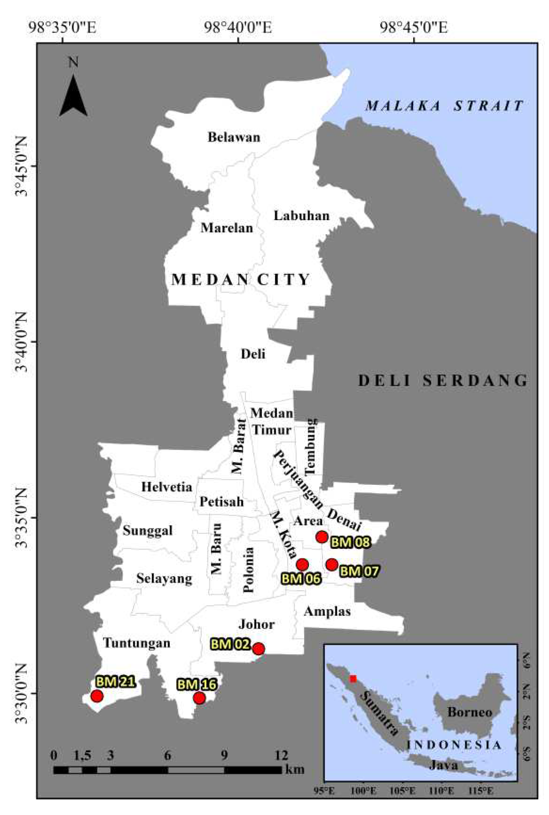
Figure 2.
Flowchart of satellite data processing using the DInSAR method with SNAP software.
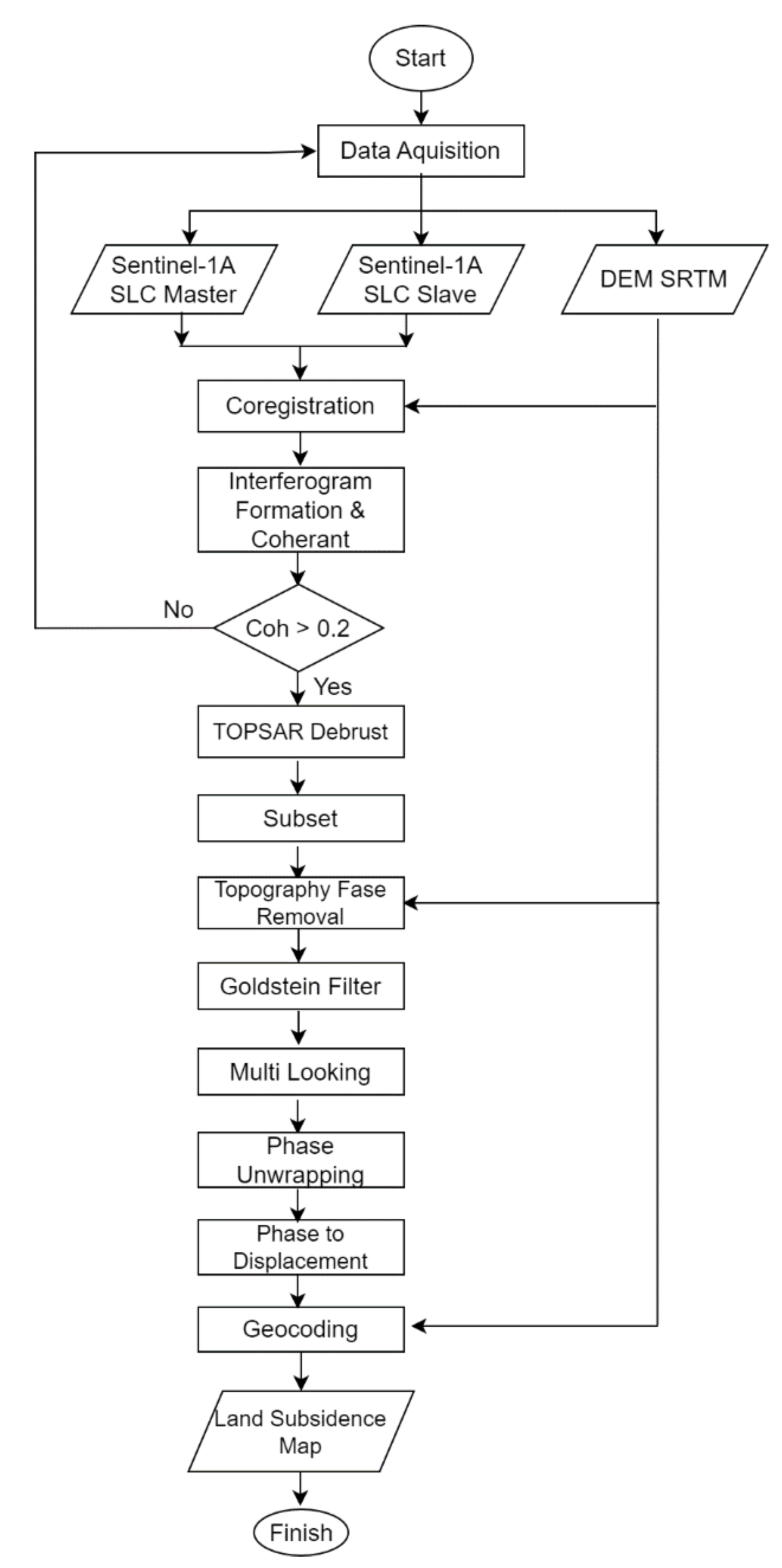
Figure 3.
Method for measuring coastal slope at the ECNS using Levelling.
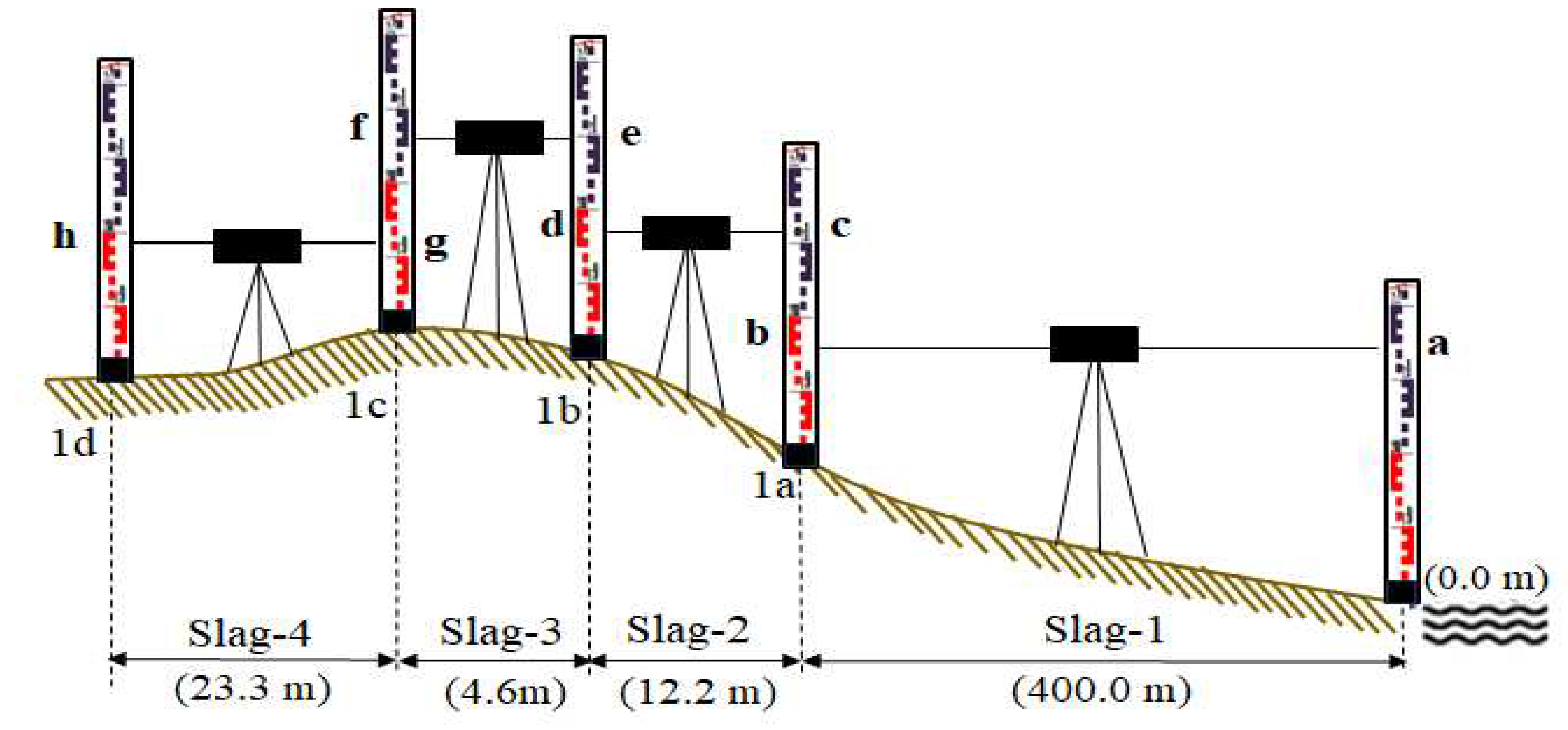
Figure 4.
Trends of sea level rise on the east coast of North Sumatra based on satellite altimetry data from 1992-2019.
Figure 4.
Trends of sea level rise on the east coast of North Sumatra based on satellite altimetry data from 1992-2019.

Figure 5.
Tidal fluctuations in the East Coast of North Sumatra for one month (September – October, 2016).
Figure 5.
Tidal fluctuations in the East Coast of North Sumatra for one month (September – October, 2016).
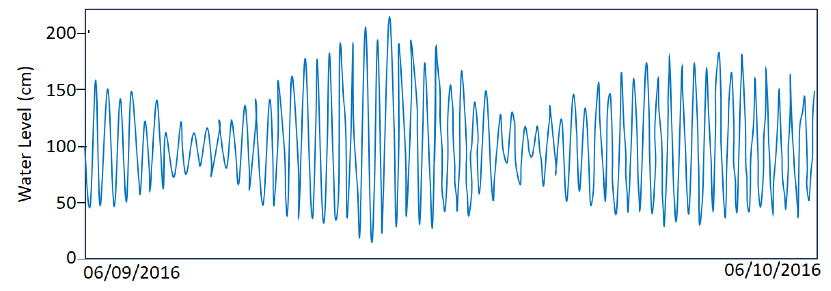
Figure 6.
Flood conditions during field surveys in Belawan City on September 19-23, 2016.
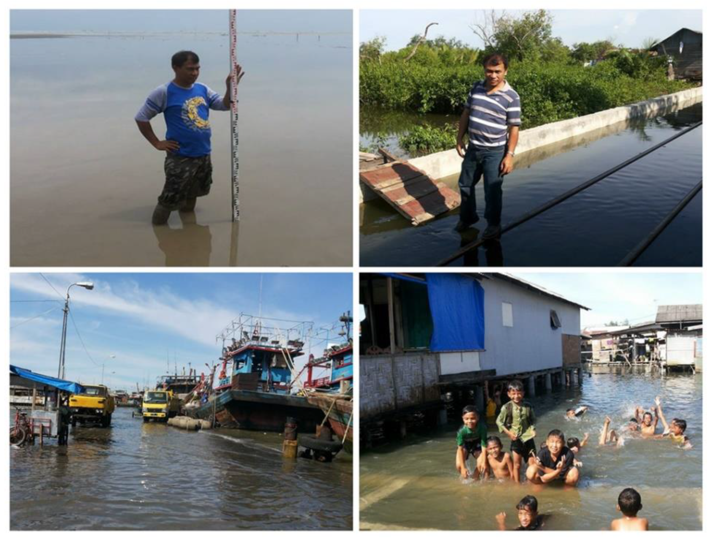
Figure 7.
Variation of tides and the height of the coastal area during the floods September 19-23, 2016.
Figure 7.
Variation of tides and the height of the coastal area during the floods September 19-23, 2016.
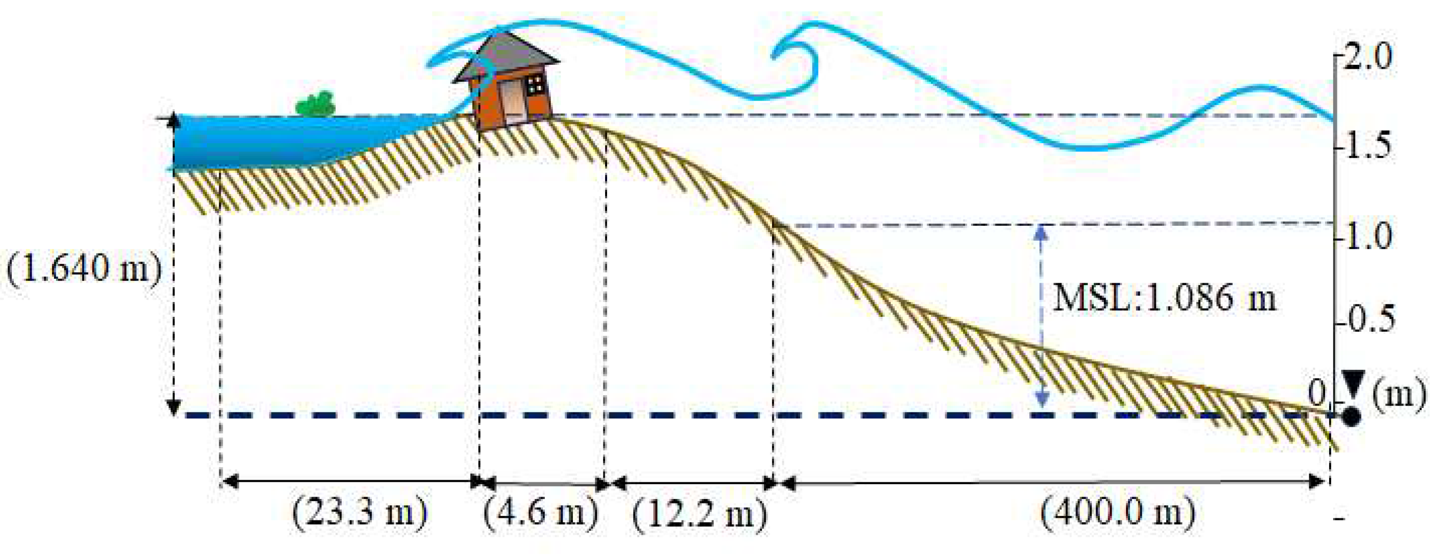
Figure 8.
The velocity of land subsidence on the ECNS and Medan City.
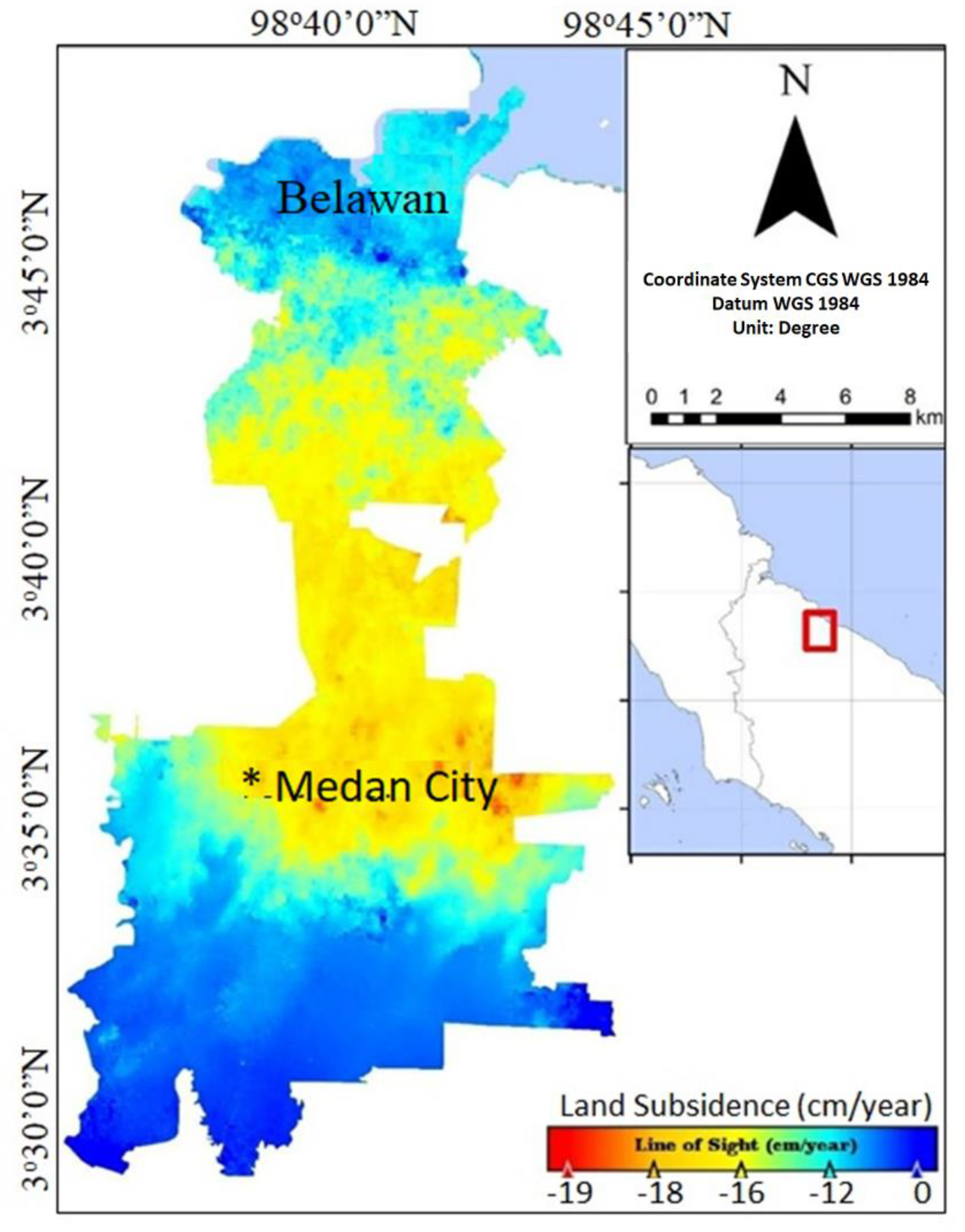
Figure 9.
Several BM positions in Medan City during the survey in September 2023.
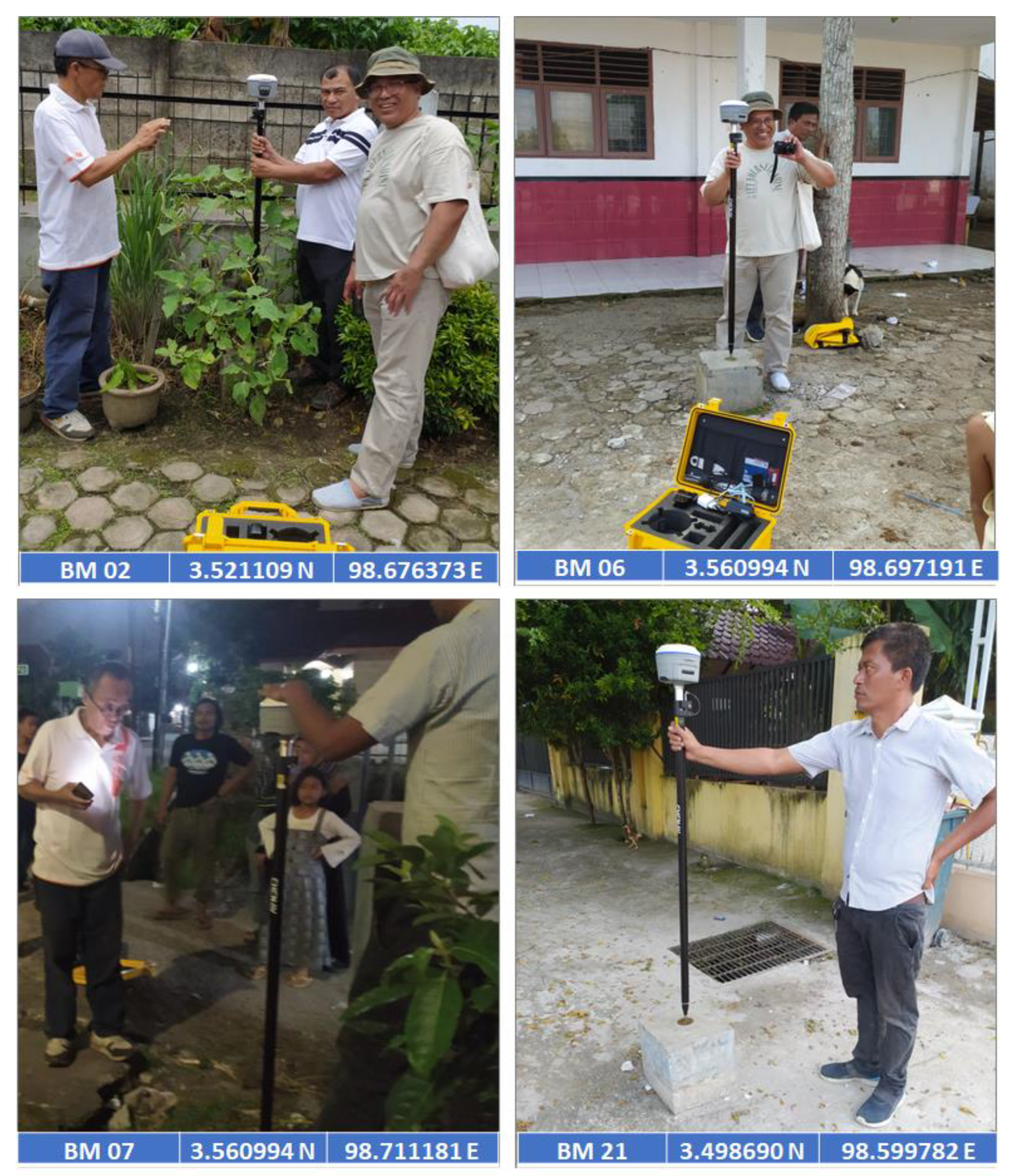
Figure 10.
Prediction of the impact of land subsidence and sea level rise in the next ten years along ECNS Beach and Medan City.
Figure 10.
Prediction of the impact of land subsidence and sea level rise in the next ten years along ECNS Beach and Medan City.
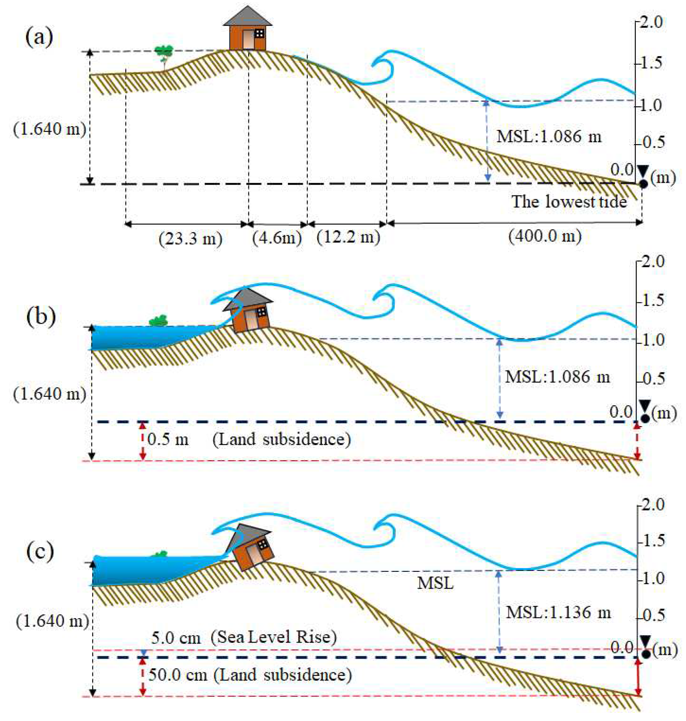
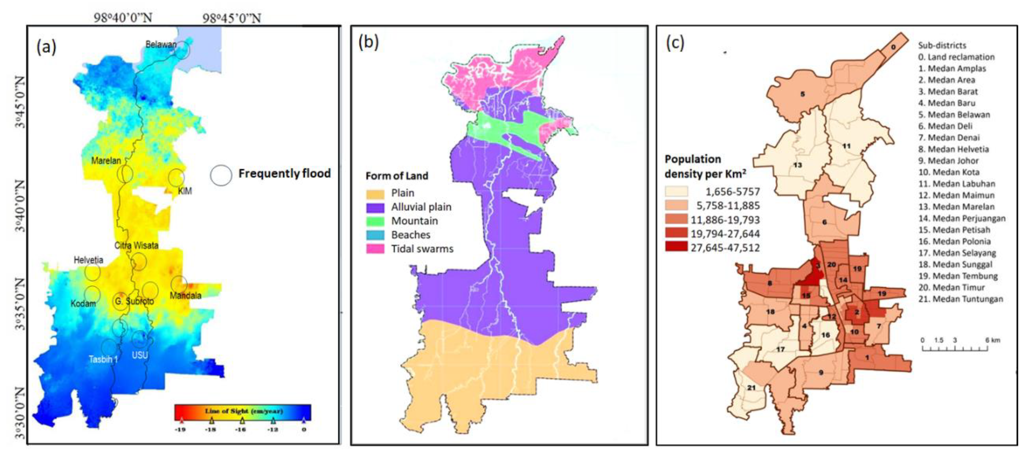
Figure 12.
Cracked building walls and falling building floors in the Belawan City.
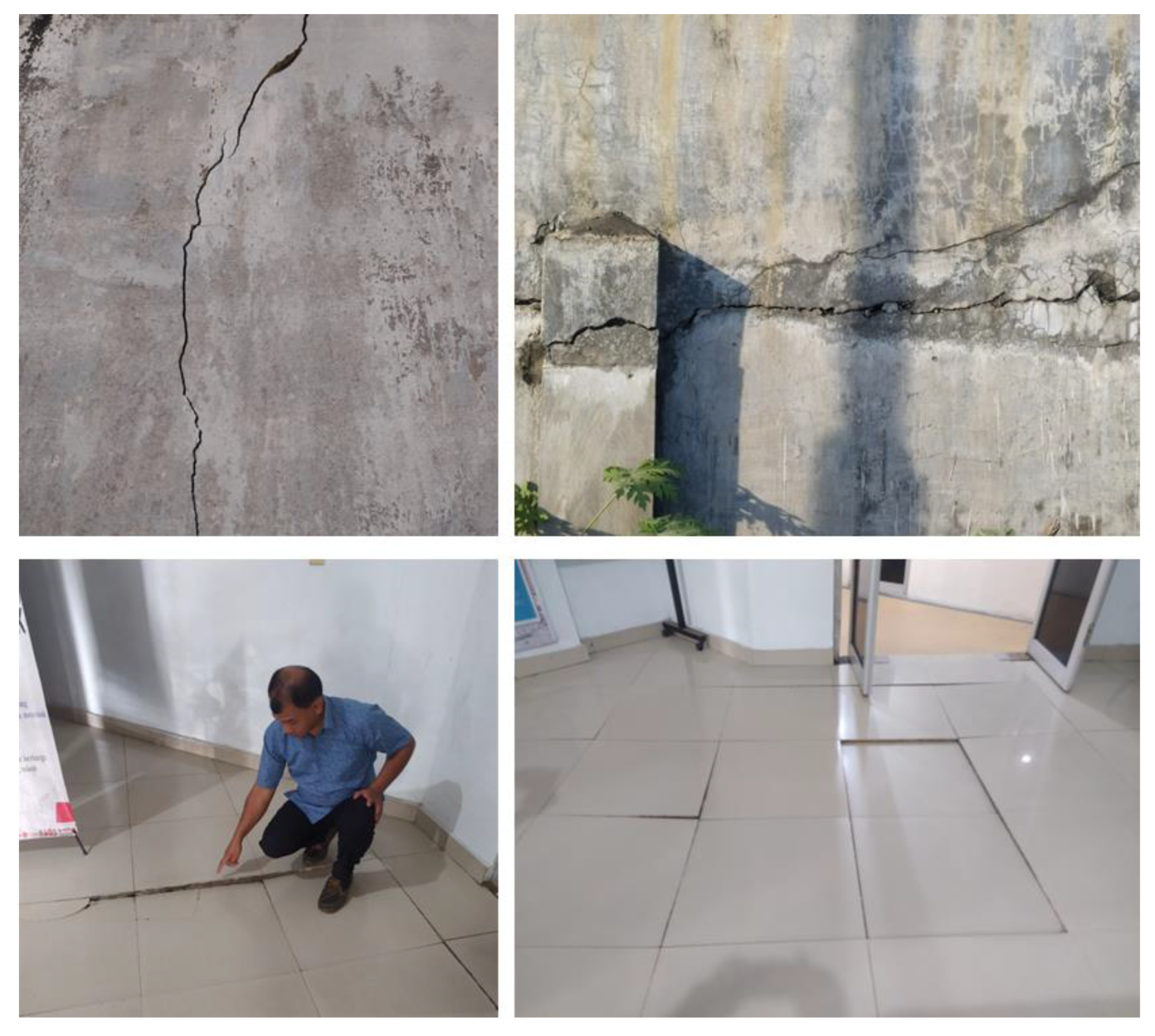
Figure 13.
Mangrove damage and biota death at Labu Beach in ECNS based on field surveys in September 2022.
Figure 13.
Mangrove damage and biota death at Labu Beach in ECNS based on field surveys in September 2022.
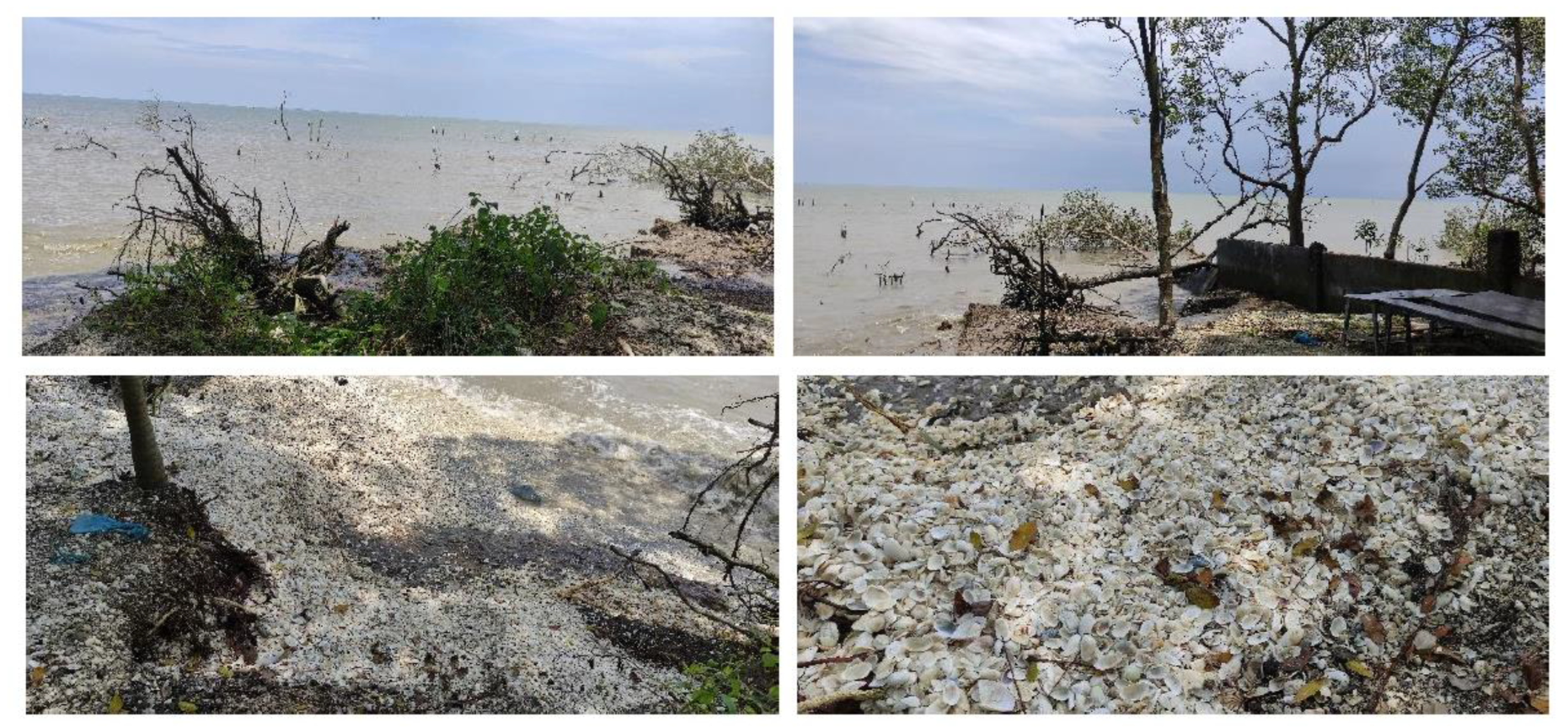
Figure 14.
Socio-economic activities and land cover along the ECNS.
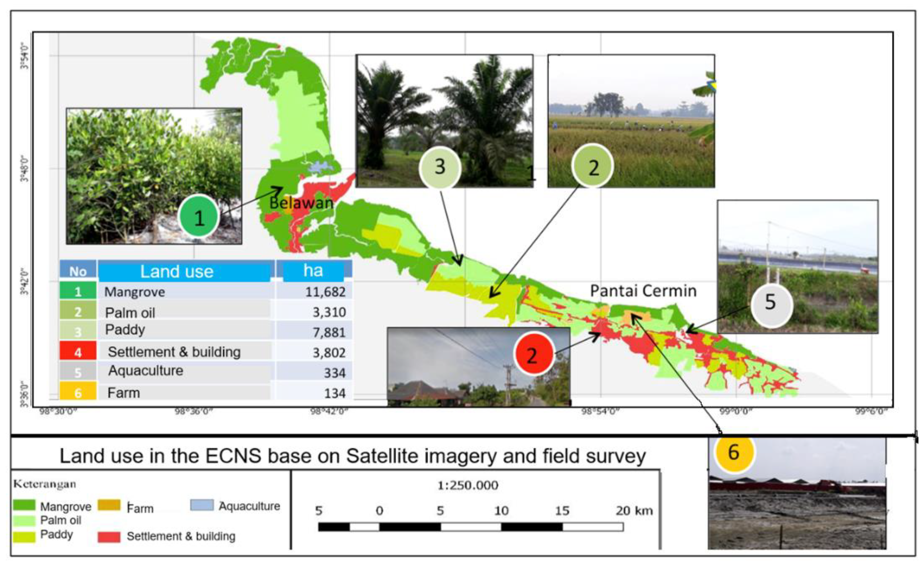
Figure 15.
Mangrove planting by coastal community at the ECNS in September 2022.
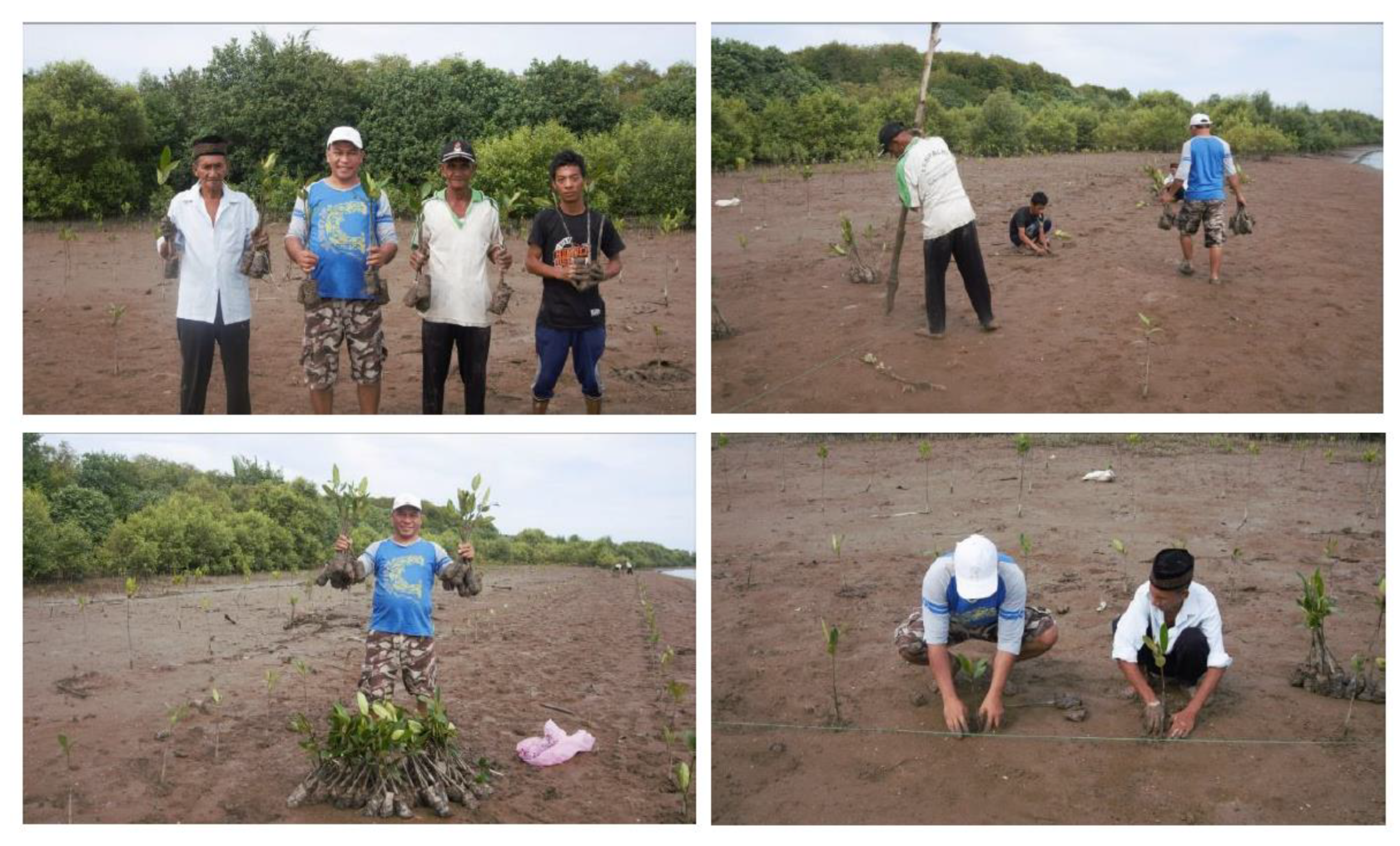

Table 1.
The vertical deformation velocity at 6 Benchmark points in Medan City.
| Bench Mark (BM) | Latitude (N) |
Longitude (E) | Land subsidence (cm/year) |
| BM 02 | 3.521109 | 98.676373 | -0.57 |
| BM 06 | 3.560994 | 98.697191 | -3.25 |
| BM 07 | 3.560994 | 98.711181 | -21.59 |
| BM 08 | 3.574129 | 98.706511 | -0.09 |
| BM 16 | 3.497786 | 98.648354 | -5.42 |
| BM 21 | 3.498690 | 98.599782 | -0.39 |
| Average | -5.22 |
Disclaimer/Publisher’s Note: The statements, opinions and data contained in all publications are solely those of the individual author(s) and contributor(s) and not of MDPI and/or the editor(s). MDPI and/or the editor(s) disclaim responsibility for any injury to people or property resulting from any ideas, methods, instructions or products referred to in the content. |
© 2023 by the authors. Licensee MDPI, Basel, Switzerland. This article is an open access article distributed under the terms and conditions of the Creative Commons Attribution (CC BY) license (http://creativecommons.org/licenses/by/4.0/).
Copyright: This open access article is published under a Creative Commons CC BY 4.0 license, which permit the free download, distribution, and reuse, provided that the author and preprint are cited in any reuse.


