Submitted:
08 October 2023
Posted:
09 October 2023
Read the latest preprint version here
Abstract
Natural radioactivity of 238U, 232Th and 40K for water and sediment samples collected from Sidi Salem dam (Tunisia) and Aïn Dalia dam (Algeria) were measured using TERRA detector of rays (gamma, beta, and alpha), Gamma-ray spectrometry and atomic absorption spectroscopy were used to analyze the levels of radionuclides and heavy metals, respectively. Heavy metals (Fe, Pb, Zn, Ni, Cu, Cr and Cd) and associated health risks in surface water and sediment of dams have been investigated in this study. The mean activity concentrations in the water samples were 1.72±0.01, 0.068±0.01 and 94.6±1.04 Bql-1 for 238U, 232Th and 40K respectively (Tunisia dam) and were 1.9± 0.24, 0.09±0.01 and 131.43±1.03 Bql-1 for 238U, 232Th and 40K respectively (Algeria dam). The mean activity concentration of 238U, 232Th and 40K measured in the sediment samples were 2.67±0.01, 0.18±0.012 and 197.87±2.01 Bqkg-1 respectively (Tunisian dam) and were 4.34±0.05, 0.27±0.05 and 287.61±3.34 Bqkg-1 respectively (Algeria dam). The activity concentration of 40K was higher than that of 238U and 232Th for the water and sediment samples. The mean activity concentrations follow the order 40K > 238U > 232Th. The mean concentrations of the heavy metals decreased in this order Fe > Pb > Zn > Ni > Cr > Cu > Cd. All measured activity concentrations and estimated radiological parameters were below world permissible limit values. Therefore, there may be no serious immediate radiological health burden on the environment and the people using the damage.
Keywords:
Natural radioactivity
; Water
; Sediment
; environmental implications
; North Africa
1. Introduction
Natural radiation is a normal part of the environment that emanates from two main sources: cosmic radiation, which originates in outer space and passes through the atmosphere, and the decay of radionuclides (radioactive isotopes or radio-isotopes) in the soil and the rock. Radionuclides undergo spontaneous disintegration into daughter nuclides with an associated emission of ionizing radiation in the form of alpha and beta particles, gamma rays and other cosmic rays. Daughter nuclides may be either stable or may themselves be radionuclides which also undergo radioactive decay. Many people might be surprised to learn that drinking water sources, especially rainwater, surface water and groundwater, can contain radioactive elements (radionuclides). Radionuclides in water can be a concern for human health because several are toxic or carcinogenic. Other radionuclides are useful tools for determining the hydrodynamic of groundwater, the residence time, the radioactivity rate disintegration, the water quality, the contamination source/rate, the age of groundwater in an aquifer or of sediment deposited at the bottom of a water body (dead zone of the dams).
The Majerda transboundary basin, a prominent watershed in North Africa, extends from Eastern Algeria, near Souk Ahras, and stretches into Tunisia. Covering a vast expanse of approximately 23,175 square kilometers, with around 7,700 square kilometers lying within Algeria's borders, it plays a crucial role in the region's water resources. The exploitation of Uranium-rich ore deposits such as diapiric rocks in the Atlas of Algeria (Souk Ahras basin), together with nuclear development around the world, has increased the risk of anthropogenic radioactive pollution. Protection against such risks is essential. Aware of the importance of the problem, the Tunisian government has already launched a program that envisages the development of studies of the radiological environment in collaboration with the International Atomic Energy Agency (IAEA) and with the World Health Organization (WHO).
This study was initiated in the transboundary basin (Tuniso-Algerian basin) known, in particular, by its richness in mines (phosphate, Pb/Zn, Fe…), diapiric sediments (clay, limestone, gypsum, salt…) and volcanic (magmatic and metamorphic rocks) deposits characterized by an average Uranium content of 35 ppm. The main objective of this study is to make in situ measurements of the natural gamma radioactivity and the geochemical analysis of (238U, 232Th, and 40K) and the toxic elements in the greatest dam in Tunisia (Sidi Salem dam) and Aïn Dalia dam from Algeria (Tuniso-Algerian transboundary basin) and to estimate the naturally occurring radioactivity in the surface water and the sediment from the dead zone of the dams.
The natural radioactivity radiation comes in many forms (varieties of cosmic rays) [1]. Human health exposure to a high concentration of background radiation (cumulative effect) may cause health risks. The taking radionuclides naturally present in the atmospheric environment, water resources (surface and groundwater), sediment or food above the international limit can cause cardiovascular epidemic and other effects of excessive radiation exposure dosing during the time [1]. In this current study area, water quality deterioration has been reported and the dependence of the inhabitants on the water supply available without security guarantees [2,3]. Many scientific reports have been conducted on the direct investigation of radioactivity levels in soil, water, food and sediment around the world, including North African countries (Tunisia and Algeria) [4,5]. No immediate harmful effects on health due to the exposure of diapiric/metamorphic rocks but in the long term by cumulative effect everything is possible and plausible. Several countries in the world suffer from this type of problem such as Tunisia, Algeria, Saudi Arabia, Kuwait, Iran, Qatar, Oman, Spain, Portugal, Niger, and Nigeria. In southern Tunisia, recent studies carried out by Hamed et al. [6], have shown high rate of radioactivity (U, Th, Rd…) and toxic heavy metals (Cd, Pb, Zn, Fe, Cr, Sr, Li…), which have exceeded the standards in the phosphate/petroleum and geothermal basin (North Western Sahara Aquifer System: NWSAS-the great transboundary basin of North Africa, divided between Algeria, Tunisia and Libya). The damage to human health is visible by an abnormal level of cancer disease in this mining polluting basin (Gafsa, Sfax, Gabes, Tozeur and Kebili), which affects all ages and both sexes. Therefore, the aim of this scientific report is to assess the radiological impact and deduce the level of possible risk from the level of radioactivity and toxic heavy metals measured in surface water and sediments in the Aïn Dalia dam in the Algerian territory (recharge zone) and the same thing in the biggest dam of Sidi Salem in Tunisian territory (discharge area).
2. Study area
This transboundary basin is located in North Africa between Algeria (recharge area) and Tunisia (discharge area) Southern of the Mediterranean Sea (Figure 1). This basin was characterized by specific geomorphology influenced by the Euro-African collision plates. It is characterized by the existence of natural volcanic deposits (diapiric, magmatic, and metamorphic rocks) in the North of the Atlas transboundary Tuniso-Algerian basin. The hydrographic network is dendritic type, it is made up of a single permanent watercourse (Majerda River) belonging to the cross-border Majerda-Mallegue watershed, the upstream of which is in the Algerian territory and the downstream in the Tunisian territory. The entire hydrographic network converges towards the Tunisian Mediterranean coast/Carthage Sea.
The study area is famous for its huge number of dams in both territories and iron, Pb, and Zn ore deposits and industrial sectors from these mine minerals...which were part of the raw materials of the large ironwork in North Africa and cement works. The Majerda basin falls within the sub-humid climatic zone, characterized by very high rainfall (500 - 1200 mm/y) and dry seasons and it is located in the trough of the great collapse ditch of the Majerda [7]. The study area is characterized by a superposition of multi-layer aquiclude/aquitard [8] with the exception of the perched karstic carbonate (limestone and dolomite) units in NE Algeria and in NW Tunisia which are very vulnerable to this type of pollution by toxic and radioactive elements, or the possibility of contamination is possible by fracturations and/surface and subsurface faults (decreasing the residence time). There are therefore significant surface reserves that are used in agricultural, domestic, industrial, and tourist areas.
The Aïn Dalia dam is located in the town of Annaba in the Majerda river (Algerian part), their coordinates are latitude 36.263439°N and longitude 7.862016°E. It has been built since 1956 to store surface water and protect cities against flooding. Concerning the geographical locations, the Sidi Salem dam is located in the town of Beja (Testour) in the Majerda River (Tunisian part). The coordinates position are latitude 36.590614°N and longitude 9.396958°E. The dam has been built since 1977 to also store surface water and use it during periods of shortage. The dimension of the foot of this ancient gigantic dam is 73 meters in height and 345 meters in length. The principal objectives of this dam are the artificial recharge of aquifers, use in tourism, and industrial activities in the coastal part of Tunisia by pipeline transfer (Bizerte, Tunis, Hammamet, Sousse, Monastir, Sfax…).
3. Materials and methods
3.1. Work methodology
Our study consists of following international steps and precautions. A combination of several factors was carried out during this study. The flowchart in the following figure summarizes all the steps (Geological/climatological data, field measurements, sampling water/sediment, laboratory analysis and results interpretation) (Figure 2).
3.2. Sample collection and preparation
In this present research, 08 samples (04 surface water and 04 solids) have been collected during spring 2023, liquid and sediment parts of the 02 dams (Aïn Dalia and Sidi Salem). The water container is sampled and washed with chloric acid (acidified 0.1 M HCl), at a rate of 10 ml per liter to avoid any kind of contamination according to international protocol. The sediment samples were placed directly in transparent cellophane bags to avoid any kind of evaporation and contact with open air (avoid the contact air/sediment). 1.5 liters of liquid water and 2.5 kg of sediment were collected, labeled and properly sealed. All the bottles without exception were first washed according to international protocol with sulfuric acid (diluted H2SO4) then rinsed with distilled water and then with dam water to avoid any external physical and/or biological contamination (temperature, humidity, and pressure).
3.3. Gamma Counting
Terra detector (Ukraine-made / April-2021) was used for the gamma counting at the Faculties of Sciences of Sciences of Gafsa (Tunisia) and the Geolab (Sétif-Algeria). The chemical analysis has been effected in the Sfax Tina/lab (Tunisia). The radioactivity detector has a resolution of 8%. A detailed description of isotopic disintegration counting has been reported by numerous specialists in the field of radioactivity [12,13]. The radioactive activity concentrations in the samples were obtained using Equation 1.
Knowing that:
M is the dried mass of the solid sample (Kilogram), V is the water sample volume (in Liter), Pγ is the gamma emission probability (or branch ratio), Tc is the counting time and ε is the detector efficiency.
3.4. Radiological parameters impact
To estimate and evaluate the radiological risk and the rate of danger to human health, some isotopic parameters were also calculated from the radioactivity measured on the ground in the study area and in the laboratory. The absorbed dose rate D (nGyh-1) due to the activity concentration of 238U, 232Th and 40K was evaluated using equation 2 according to international references.
The parameters (CU, CTh and CK) are the radioactivity concentration in Bqkg-1 and Bql-1 for the solid and water samples from the study area, respectively, while (CU = 0.462), (CTh = 0.604) and (CK= 0.0417) are their dose conversion factors respectively [8]. The radium equivalent (Raeq) activity index was determined using equation 3.
The external radiation hazards (Hext) and the internal radiation hazards (Hint) were calculated using equations 4 and 5.
Radiation induced leukemia or gonadal damage is a possible occurrence when exposed to excess radiation, hence the need to estimate the annual gonadal equivalent dose (AGED). This was done using equation 6.
These parameters are the radioactivity concentrations in Bqkg-1 for 238U, 232Th, and 40K in the given samples.
The effective dose (H: health risk) due to the element radioactivity detected in the water samples was calculated using equation 7 [9].
Ra is the radioactivity concentration of radionuclide in the water samples (Bql-1), Ai is the annual intake (1y-1) and Cf is the ingested dose conversion factor for radionuclides (mSvy-1), and varies with radionuclides and the age of individuals ingesting the radionuclides. Adding contributions from all radionuclides present in the study area, the total annual effective dose HE (mSvy-1) to an individual was found for the studied samples using equation 8.
HE = ∑(Ra . Ai . Cf)
According to the international protocol, during our study we adopted a subdivision according to different ages for good precision. The dose conversion factors used in the calculation and the annual effective dose were adopted from International Commission on Radiological Protection [10,11,12] for nine age groups (Table 2).
4. Results and Discussions
4.1. Spatial distribution of the radioactivity in the Dams
The concentrations of 238U, 232Th, and 40K activities for liquid and solid samples are shown in Figure 3 and Figure 4 respectively. The mean activity concentration measured for the water samples in the upper dam (Tunisia) was 1.74, 0.07, and 95.8 Bql-1 for 238U, 232Th, and 40K respectively. The mean concentration measured on the lower side of the dam was 1.70, 0.066, and 93.4 Bql-1 for 238U, 232Th, and 40K respectively. The mean activity concentrations follow the order 40K > 238U > 232Th. The mean activity concentration measured in the sediments collected at the upper side of the Sidi Salem dam (Tunisia) was 2.67, 0.18, and 197.87 Bqkg-1 for 238U, 232Th, and 40K respectively. Concerning the Algerian Dam (Aïn Dalia), the mean concentration measured on the lower side of the water dam was 1.9, 0.09, and 131.43 Bql-1 for 238U, 232Th, and 40K respectively. The mean activity concentration follows the order 40K > 238U > 232Th. The mean activity concentration measured in the sediments collected at the upper side of the dam was 4.34, 0.27, and 287.61 Bqkg-1 for 238U, 232Th, and 40K respectively. It was observed that the activity measured in the sediments was higher by a factor range of 1.57, 2.64, and 2.1 for 238U, 232Th, and 40K respectively, than what was measured in water samples in Sidi Salem (Tunisia). In the Algerian territory (Aïn Dalia Dam), it is the range of 2.3, 3, and 2.2 for 238U, 232Th, and 40K respectively, then what was measured in water samples. This is not surprising since sediments will transfer part of the radionuclide contents to the water and the Algerian constitute the origin of this natural radioactivity by diapirism. The estimated radiological impact parameters are presented in Table 1. The absorbed dose rate (nGyh-1) for sediment samples was below the word standard limit value (Table 1).
The estimated annual gonadal equivalent dose (AGED) is also less than the world limit of 1 Svy-1. The calculated absorbed dose for water was used to further calculate the total annual effective dose HE (mSvy-1) as shown in Table 2. The total annual effective dose obtained for all age groups was below the permissible reference limit [12]. This scientific report shows that this radioactivity contamination may be dangerous by the cumulative effect in the long term (depending on the socio-economic in this transboundary basin) and depending also in the future regional and global scenario in the North Africa basin and its relationship with the Mediterranean Basin.
Aïn Dalia Dam (Recharge area-Algeria) and Sidi Salem Dam (Discharge area-Tunisia) reveals significant variations in radioactivity levels. The results indicate that the highest concentrations were observed in the lower part of the dams (sediment parts) which can be attributed to the organic matter and the clay minerals adsorption of the radioactivity [6]. The dead area (stagnation and compact zone in the bottom part) in the dam is composed by the stratified/compacted sediments. In this part depending to the drainage network input from the mount’s erosion (clay, gypsum, sand, limestone/dolomite…). That’s why the nearest dam (Aïn Dalia) from the sources of the natural diapiric radioactivity (salt, clay, sandstones…) from the Algerian Atlas is very enriched by this natural diapiric and metamorphic radioactivities. The decrease of the radioactivity rate from the Algerian territory to the Tunisian territory is due to the process of dispersion of the sediments (contact air/ water/rock interactions) in many effluents of the drainage network of Mallègue-Majerda basin (Tuniso-Algerian transboundary basin) [14,15].
This radioactive distribution can be influenced by the tectonic activity, rock types, aquifer intercommunications, residence time, rain/wind rate, climatic parameters, and direction of the rain/wind, which can transport the radioactive particles and disperse them in different directions in the Majerda basin from the Algerian Atlas to the Mediterranean Sea (Tunis Gulf) (approximately within a radius of 300 km with a wind speed which oscillates between 20 and 100 km/h which depends on regional and global climatic conditions). The tectonic impact has a good role in the rechargeability/contamination of the aquifers and in the intercommunication between them in the study area [16,17].
These dams (surface water and soil) show significant radioactivity variability. High levels of total radioactivity are generally in the range of 0.21 μSv to 0.28 μSv in the soil in Aïn Dalia dam and it increases with the water depth. From this recharge area (Algerian area) to Sidi Salem Dam (Tunisian discharge area), the levels of the total radioactivity are generally in the range of 0.2 μSv to 0.23 μSv in the soil and it increases with the depth also. It is the cumulative impact on the water and on the soil. These higher values are mainly recorded in specific areas such as the cities of Tebessa, Souk Ahras, Annaba, Jendouba, El Kef, and Beja, which are associated with the mining and ore industry and also with the presence of the diapiric and the metamorphic rocks in the high altitude (1,500 -2,800 m) [18,19,20,21,22].
These values are often observed in regions close to the surrounding mountainous areas, where the geological characteristics and the agriculture/industrial activities may play a role in the increase of radioactivity in the soil. These variations in radioactivity levels reflect the complexity of the geology, tectonic, environmental processes and socio-economic of North Africa area (Mallègue-Majerda basin of the Tuniso-Algerian transboundary basin). It is important to note that the radioactivity values mentioned are indicative and may vary depending on many factors, including local geological, geomorphological, climatic conditions, soil erosion and human activities. In this context, the study area is climatological under the influence of two types of air masses: (1)-Mediterranean origin and the transport engine is the north/south direction wind, any radioactive activity (enrichment zone) in the southern European countries can be transported into this direction (to North Africa and the western part of the Middle East). (2)- The second air mass is desert/Atlantic, and the direction is South/North and West/East (to North Africa and the western part of the Middle East). All extraction activities from uranium mines as is the case in Niger and other countries in Central Africa will be transported by the wind and will be discharged in the study area (2000 Km) and in the rest of the MENA region countries (3000 to 3500 Km). The radioactivity disintegration can be resume in these equations:
238U → 234Th + 4He
234Th → 234U + 4He
234U → 230Th + 4He
230Th → 226Ra + 4He
226Ra → 222Rn + 4He
Regional and global climate change has a key role in the balances and imbalances of ecological and environmental ecosystems. The conceptual model of the hydrodynamic of the surface water in these dams vs. the regional/global climate variation (arid/humid) (Figure 2 and Figure 3), shows that the organic matter (OM) and the clay minerals have a good role in the radioactivity adsorption, in the immobilization of the radioactive isotopes and in the cosmic radiation. Combined with the influence of the irregularity of the flooding stage due to the regional and global climate variability in North Africa, the increasing arid paleo-climate played a very important role in decreasing the radioactivity by reducing the supply of clay minerals (adsorption/release), radioactive materials, and other minerals. This situation has also benefited primary paleo-productivity and anoxic conditions; their integrated effect could induce sapropelic “OM” accumulation (preservation and/or degradation). Therefore, the relationship between the OM content/clay minerals and the radioactivity is very complex; Rather than only assuming a positive correlation, its characteristics and formation mechanism need to be analyzed in a specific environment.
In the humid climate (Figure 2), the stormwater brings sediments rich in radioactive elements (clay, OM, sandstone, salts…), and rain showers recharge the dams and cause heterogeneity in the water column of the dams. This is why the level of radioactivity is high in the water column during wet periods. However, during the arid climate (Figure 3) when rain showers are almost null, the water column will be stratified (evaporation and density effects). From where the radioactive elements are deposited at the bottom part to their weight and the rate of radioactivity will be important in the basal parts of the dams. Moreover, during this period the shallow aquifer (alluvial and karstic) after the dams will be recharged by infiltration (period of deep-water contamination).
In this present scientific report, it was noted that in all surface water samples in this tectonized transboundary basin in North Africa, the concentrations of 238U were higher than those of 232Th. The presence of uranium-bearing minerals associated with the upwelling of diapiric/metamorphic/sedimentary rocks together with limestone, dolomite, marl, salt, gypsum and clay commonly found in Tebessa, Souk Ahras and Annaba mounts (in Algerian Atlas) and in El Kef and Jendouba mounts (in Tunisian Atlas) can explain this observation in this report. The variability of the radio-activities can also be attributed to the oxydo-reduction conditions. Sometimes the fossil geothermal (40 Ky - 45 Ky) upwelling through the major faults increases the dissolution of these radioactive minerals.
40K is a radionuclide which abounds in the earth's crust and Ocean [13]. Its high rate in the surface water (dams and drainage networks) of the transboundary Majerda area may be due to the leaching of topsoil of nearby farmlands that employ inorganic potassium fertilizers to boot soil nutrients (orange, wheat, barley...). Using fertilizers in agricultural land, this isotope can percolate by infiltration and be leached in significant proportions in quantity into nearby vulnerable aquifers (alluvial and karstified aquifers). The rational safety of drinking water is an important water quality parameter of concern [8]. Most countries based their rational risk regulation and guidelines for drinking water on the UNSCEAR reports [8] and WHO limits [11]. The 40K and 238U rates obtained in this present study were significantly higher than UNSCEAR and WHO world average limits of 10.0 and 1.0 Bq.l-1 respectively for drinking water. That of 232Th is near the limit of 0.1 Bq.l-1. However, the values of the radioactivity in the soil show severe contamination and can be very dangerous for human health. From the radiological point of view, the accumulation of radionuclides 238U, 232Th and 40K due to the ingestion of water from Majerda dams could present a low dose radiological risk of longer-term effects on health status of the Majerda population (the higher agriculture land in Tunisia and in North Africa, as it has been known for a long time until today: Matmour Roma/Carthage/Tunisia). When compared with other studies from some parts of the world (Table 3), it was found that the mean activity concentration of 40K and 238U was greater than those observed in water samples from Port Harcourt (Nigeria) [23]; Kuala Lumpur (Malaysia) [24], Ghana, Nigeria, Egypt, Makkah (Saudi Arabia) [25] and Gafsa (Tunisia) [6]. 232Th concentration is lower than that found in some of these locations except for the value 0.12 Bq.l-1 [25] observed in drinking water from KSA.
The 238U, 232Th, and 40K concentrations observed in the study area (transboundary basin Tuniso-Algerian basin) are also compared with those reported for other regions of MENA region (North Africa and Middle East) and worldwide average values in Table 3. However, the mean value of activity concentration of 238U for the Tunisia zone was higher in the southern part of Tunisia (phosphate/petroleum mining basin) [6]. But lower in the Majerda basin (study area) when compared to the average values reported for the Middle East regions (KSA, Qatar, Bahrain, Emirate, Kuwait…) and the worldwide average values, the overall mean value for the entire study region was similar to these reported values.
Aim, the individual mean values of 238U, 232Th and 40K activity concentration for each zone as well as the overall mean value were lower when compared to the average value reported for the Middle East and the world. It is interesting to observe that the 238U activity is higher in the soil when compared to the 232Th concentration in the proposed uranium-mining region (cumulative impact).
High U, Th, and K rates have been detected in surface water associated with diapirism/metamorphic/sedimentary rocks of the Algerian Atlas. These high concentrations are attributed to uranium minerals in granites and uranium minerals in pegmatites associated with these rock types of the Tuniso-Algerian Atlas and maybe also the result of the combination of these regional rocks' origin with the atmospheric circulation (Mediterranean origin from the north and Atlantic/desertic origin from the south).
4.2. Risk map of the radioactivity distribution in the study area
Through the combination of the 12 parameters (Altitude, tectonic/fracturation, slope, lithology, aquifer levels/thickness, radioactivity rate, drainage network, surface/groundwater flow direction, rate/direction of rain and wind), we can establish the risk map (Figure 5a,b). The most significant values are observed at Aïn Dalia Dam located near the diapirism outcrops (Algerian territory) and also at Sidi Salem Dam (Tunisian territory) by cumulative effect and finally in the final outlet (Tunis Gulf of the Mediterranean Sea/Carthage Sea) with average values. While the lowest values are observed in high altitudes in the study area. The drainage network with the permanent surface water has an important role in the transportation of the radioactive sediment and also has a role in the dilution of this radioactivity from the source of radioactivity (diapirism sediment) to the Tunis Gulf (cumulative sediments).
The following map (Figure 6) shows that the highest levels of radioactivity are observed at the level of the diapirsm rocks which constitute the source and the origin of the contamination in the Algerian territory (Transboundary Algero-Tunisian Atlas). We also see that the outlet of the watershed (Tunis Gulf) is marked by very high levels of radioactivity. This is essentially due to the cumulative effect. The lowest values are observed at high altitudes, generally carbonates, whose the radioactivity rate is low.
4.3. Spatial distribution of the toxic heavy metals in the study area
The result of the concentrations of the toxic heavy metals (Fe, Pb, Zn, Ni, Cr, Cu and Cd) in the surface waters of the two dams of the Majerda River is also presented in Table 4. The concentrations of Fe, Pb, Zn, Ni, Cr, Cu and Cd in surface water range from 5430 to 9700 mg/L, 0.022 to 0.168, 0.018 to 0.142, 0.065 to 0.366, BDL to .0351, BDL-0.071 and BDL-0.048 mg/L respectively. The average concentration of heavy metals follows the trend Fe > Pb > Zn > Ni > Cr > Cu > Cd. This command indicates the dominance of Fe, Pb and Zn in surface water samples from the Aïn Dalia dam (Algeria). The average concentration level of Fe (7565 mg/L), this value is much higher than the standard values (0.3 mg/l) it is almost 25,217 times, Cu (0.0225 mg/L) was found to be below 2.00 mg/L of the WHO recommended limit. Ni (0.086 mg/L), Cr (0.061 mg/L) and Cd (0.009 mg/L) were slightly above the WHO recommended levels of 0.07, 0.05 and 0.003 mg/L respectively for drinking water [11], the Pb (0.218 mg/L) was found to be above the WHO authorized limits of 0.01 mg/L.
The implication of drinking such contaminated water may be in retarding certain biological and/or physiological processes. The relatively higher level of Pb and Ni in the water samples may be due to the anthropogenic pollution (mining extraction) along the Majerda River which feeds the two dams in this transboundary basin. Runoff from mines, dumps, and agricultural practices visibly present along the road and around the riverbank are plausible sources of heavy metal pollution from the river dam. There is also evidence of rock weathering and water-rock interaction from mineable and abandoned quarries as another source of metal pollution. Fertilizers and other agrochemical applications are a major contributing factor to the ubiquity of Pb in surface water bodies [9]. Lead is mainly used in the manufacture of lead batteries, it remains in landfills near rivers and streams and can serve as a source of lead pollution. This can diffuse through soil pores into groundwater and surface water [34,35].
A high Pb rate in surface water from dams or through a cumulative effect can cause serious health complications such as poor memory, social disturbances, and reduced cognitive ability, while long-term exposure can lead to anemia [36]. Ni and Fe are found to be almost ubiquitous and very abundant elements in the environment (diapiric, meta-magmatic, and metamorphic rocks) [37]. The cropland is the main occupation of the inhabitants of the study area; therefore, a high concentration of metals in nearby streams and rivers is expected when the use of nitrogen fertilizers (synthetic nitrogen fertilizers and organic manure) is common [38]. According to Hamed et al. [6,39], Cd is also present in a polluting form in phosphate fertilizers. The soil affected by sulfate minerals increased in acidity, in many cases reaching values below pH = 3.5 due to the acidity of the water (pH ≈ 5.2) and the pyrite sludge which, given its heterogeneity, ranged between 3.8 < pH < 5 [6]. The acidification of soils was aggravated by the oxidation of the sludge at the surface and even continued after the sludge removal tasks. The oxidation of the sulphides involves oxidation, hydrolysis, and hydration processes that Stumm and Morgan [40] summarized in Eq. (9).
FeS2 + 3.75O2 +3.5H2O → Fe(OH)3 + 2H2SO4
This reaction starts with the release of Fe2+ and under oxidizing conditions is converted into Fe3+. When soil pH is above 4, then Fe3+ precipitates as iron hydroxide and the pH becomes more acidic (Eq. (10)).
Fe3+ + 3H2O → Fe(OH)3 + 3H+
However, when soil pH remains under 4, the Fe3+ can oxidize the pyrite. This reaction is faster and can generate more acidity (Eq. (11)).
FeS2 + 14Fe3+ + 8H2O →15Fe2+ + 2SO4 2− + 16H+
The concentration of these metals in solid samples is almost 20 times that in water, this is explained by the cumulative effect and by the presence of organic matter and fine clay sediments which are fixators of these toxic metals. In the polluted area by these metals can provoke many serious human illnesses.
5. Conclusion and recommendations
The radioisotopes of 238U, 232Th and their decay descendants as well as the single non-series 40K are transported to water by leaching and by infiltration in the vadose zone. This specific study will serve as a witness and index to carry out any environmental health monitoring in the transboundary basin of North Africa (Tunisian-Algerian zone) and why not in other similar area. The derived result will serve as a transposable study in other areas to verify any geochemical levels of surface and underground water resources (drinking water from dams, hill lakes and shallow aquifers). It will also provide future guidelines for providing safe drinking water sources to the community in the study area and may be transferable to similar locations in the MENA region (North Africa and the Middle East). The ingestion of water contaminated with radionuclides will result in the irradiation of human internal organs by alpha, beta, gamma and other types of radiation. This typical study showed that radioactivity in water give clear information from which the average radiation exposure from different sources can be estimated. Likewise, it showed that different types of fatal outbreaks (cancer) due to ingested radon from drinking water are equal to the total number of lung cancers due to radon inhalation. Continuous exposure to heavy metals and other chemical contaminants, even at low levels, could have a harmful effect on human health, especially at sensitive ages (under 17 years: the growing age of children).
Through this study, it is time to become aware of the control of transboundary water resources and to make master plans for quality and quantity control. To control the relationship between natural radiation and anthropogenic activities and the fact that human senses cannot detect low radiation (excluding the mine workers). International collaborations are essential to stop this type of quality degradation, especially of air and surface waters, which are in direct contact with the atmospheric column, ecosystem and human health. A global view on an international scale is crucial to fully understand the regional climatic situation in relation to the socio-economic development of the regions.
Author Contributions
“Conceptualization, Y.H.; and E.E.; methodology, Y.H.; software, Y.A; and Y.H; validation, Y.H, E.E. and R.H.; formal analysis, Y.H.; investigation, Y.H.; and E.E.; resources and data curation, R.H. A.B.S, and E.E.; writing-original draft preparation, Y.H.; writing review and editing, Y.H, M.G, R.H., and E.E.; visualization, R.H. and M.G.; supervision, R.H .; E.E. All authors have read and agreed to the published version of the manuscript”.
Acknowledgments
The authors would like to thank the GeoLab/ExpertGeo-Group. Lab-Aïn Azel-Setif Algeria for the TERRA material of gamma/beta radioactivities and to thank the staff of the private Sfax Tina/lab. (Tunisia). The authors express their grateful thanks to the staff of the International Association of Water Resources in the Southern Mediterranean Bain-Tunisia and the Chairmen and all members of WREIANA SYMPOSIUM (Tunisia - April 25-27, 2023) for generously contributing their time and expertise to improve the quality of the manuscript.
Conflicts of Interest
The present paper is an original work, it is the first in the study area, and all the authors declare that they have no conflicts of interest. The authors jointly carried out this research study and they confirm that they are not associated with or involved in any profitable organization or company that has any financial interest. All authors have read and agreed to the published version of the manuscript.
References
- International Atomic Energy Agency (IAEA). Measurement of radionuclides in food and environments. A guide book, IAEA Technical Report, 1989, Series No. 295, Vienna.
- Hamed, Y. Hydrogeological, Hydrochemical and Isotopic characterization of deep groundwater in Kef Basin (NW Tunisia) Master report, Faculty of Sciences of Sfax, 2004, p 180.
- Ayadi, Y.; Redhaounia, B.; Mokadem, N.; Zighmi, K.; Dhaoui, M.; Hamed, Y. Hydro-geophysical and geochemical studies of the aquifer systems in El Kef region (Northwestern Tunisia). Carbonates Evaporites 2019, 34, 1391–1413. [Google Scholar] [CrossRef]
- Hamed, Y.; Hadji, R.; Ncibi, K.; Hamad, A.; Ben Sâad, A.; Melki, A.; Khelifi, F.; Mokadem, N.; Mustafa, E. Modelling of potential groundwater artificial recharge in the transboundary Algero-Tunisian Basin (Tebessa-Gafsa): The application of stable isotopes and hydroinformatics tools *. Irrig. Drain. 2021, 71, 137–156. [Google Scholar] [CrossRef]
- Hamad, A.; Hadji, R.; Bâali, F.; Houda, B.; Redhaounia, B.; Zighmi, K.; Legrioui, R.; Brahmi, S.; Hamed, Y. Conceptual model for karstic aquifers by combined analysis of GIS, chemical, thermal, and isotopic tools in Tuniso-Algerian transboundary basin. Arab. J. Geosci. 2018, 11, 409. [Google Scholar] [CrossRef]
- Hamed, Y.; Khelifi, F.; Houda, B.; Ben Sâad, A.; Ncibi, K.; Hadji, R.; Melki, A.; Hamad, A. Phosphate mining pollution in southern Tunisia: environmental, epidemiological, and socioeconomic investigation. Environ. Dev. Sustain. 2022, 1–18. [Google Scholar] [CrossRef]
- Ayadi, Y.; Mokadem, N.; Besser, H.; Redhaounia, B.; Khelifi, F.; Harabi, S.; Nasri, T.; Hamed, Y. Statistical and geochemical assessment of groundwater quality in Teboursouk area (Northwestern Tunisian Atlas). Environ. Earth Sci. 2018, 77, 349. [Google Scholar] [CrossRef]
- UNSCEAR, United Nations Scientific Committee on the Effects of Atomic Radiation. Sources and Effects of Ionizing Radiation, 2000, Volume I: Annex A. Dose Assessment Methodologies. United Nations, New York.
- ICRP, International Commission on Radiological Protection. Protection of the Public in Situations of Prolonged Radiation Exposure, ICRP Publication82. Ann. ICRP. 29:1 – 2, 2000. 1: 29, 2000; 2.
- ICRP, International Commission on Radiological Protection, Age-dependent Doses to Members of the Public From Intake Of Radionuclides: Part 5, Compilation of Ingestion and Inhalation Dose Coefficients. ICRP Publication 72, Pergamon Press, Oxford, United Kingdom, 1996.
- WHO, World Health Organization, Guidelines For Drinking-Water Quality (4th Ed.), WHO Library Cataloguing-in-Publication Data NLM classification, Geneva, 2011 WA 675. 2011.
- USEPA, US Environmental Protection Agency, Risk Assessment Guidance For superfund. Volume I, Human Health Evaluation Manual : Part E, Supplemental Guidance for Dermal Risk Assessment), Report EPA/540/R/99/005, US Environmental Protection Agency, Washington, DC. 2014.
- El Arabi, A.M.; Ahmed, N.K.; Din, K.S. Natural radionuclides and dose estimation in natural water resources from Elba protective area, Egypt. Radiat. Prot. Dosim. 2006, 121, 284–292. [Google Scholar] [CrossRef] [PubMed]
- Boulemia, S.; Hadji, R.; Hamimed, M. Depositional environment of phosphorites in a semiarid climate region, case of El Kouif area (Algerian–Tunisian border). Carbonates Evaporites 2021, 36, 1–15. [Google Scholar] [CrossRef]
- Mahleb, A.; Hadji, R.; Zahri, F.; Boudjellal, R.; Chibani, A.; Hamed, Y. Water-Borne Erosion Estimation Using the Revised Universal Soil Loss Equation (RUSLE) Model Over a Semiarid Watershed: Case Study of Meskiana Catchment, Algerian-Tunisian Border. Geotech. Geol. Eng. 2022, 40, 4217–4230. [Google Scholar] [CrossRef]
- Ncibi, K.; Mastrocicco, M.; Colombani, N.; Busico, G.; Hadji, R.; Hamed, Y.; Shuhab, K. Differentiating Nitrate Origins and Fate in a Semi-Arid Basin (Tunisia) via Geostatistical Analyses and Groundwater Modelling. Water 2022, 14, 4124. [Google Scholar] [CrossRef]
- Brahmi, S.; Baali, F.; Hadji, R.; Brahmi, S.; Hamad, A.; Rahal, O.; Zerrouki, H.; Saadali, B.; Hamed, Y. Assessment of groundwater and soil pollution by leachate using electrical resistivity and induced polarization imaging survey, case of Tebessa municipal landfill, NE Algeria. Arab. J. Geosci. 2021, 14, 1–13. [Google Scholar] [CrossRef]
- Ncibi, K., Hadji, R., Hajji, S., Besser, H., Hajlaoui, H., Hamad, A., Mokadem, N.; Ben Saad, A.; Hamdi, M.; Hamed, Y. Spatial variation of groundwater vulnerability to nitrate pollution under excessive fertilization using index overlay method in central Tunisia (Sidi Bouzid basin). Irrigation and Drainage 2021, 70, 1209–1226. [CrossRef]
- Fredj, M.; Hafsaoui, A.; Riheb, H.; Boukarm, R.; Saadoun, A. Back-analysis study on slope instability in an open pit mine (Algeria). Nauk. Visnyk Natsionalnoho Hirnychoho Universytetu 2020, 24–29. [Google Scholar] [CrossRef]
- Benmarce, K.; Hadji, R.; Zahri, F.; Khanchoul, K.; Chouabi, A.; Zighmi, K.; Hamed, Y. Hydrochemical and geothermometry characterization for a geothermal system in semiarid dry climate: The case study of Hamma spring (Northeast Algeria). J. Afr. Earth Sci. 2021, 182, 104285. [Google Scholar] [CrossRef]
- Zerzour, O.; Gadri, L.; Hadji, R.; Mebrouk, F.; Hamed, Y. Geostatistics-Based Method for Irregular Mineral Resource Estimation, in Ouenza Iron Mine, Northeastern Algeria. Geotech. Geol. Eng. 2021, 39, 3337–3346. [Google Scholar] [CrossRef]
- Dib, I.; Khedidja, A.; Chattaha, W.; Hadji, R. Multivariate statistical-based approach to the physical-chemical behavior of shallow groundwater in a semiarid dry climate: The case study of the Gadaïne-Ain Yaghout plain NE Algeria. Min. Miner. Deposits 2022, 16, 38–47. [Google Scholar] [CrossRef]
- Akpolile, F.A.; Ugbede, F.O. Natural radioactivity study and radiological risk assessment in surface water and sediments from Tuomo river in Burutu, delta state Nigeria. J. Nig. Ass. Math. Phys. (J. NAMP). 2019; 50, 267–274. [Google Scholar]
- Khandaker, M.U.; Uwatse, O.B.; Khairi, K.A.B.S.; I Faruque, M.R.; A Bradley, D. TERRESTRIAL RADIONUCLIDES IN SURFACE (DAM) WATER AND CONCOMITANT DOSE IN METROPOLITAN KUALA LUMPUR. Radiat. Prot. Dosim. 2019, 185, 343–350. [Google Scholar] [CrossRef] [PubMed]
- Al-Zahrani, K. H.; Baig, M. B. Water in the Kingdom of Saudi Arabia: sustainable management options. J Anim Plant Sci, 2011; 21, 601–604. [Google Scholar]
- Olszewska-Wasiolek, M. Estimates of the Occupational Radiological Hazard in the Phosphate Fertilizers Industry in Poland. Radiat. Prot. Dosim. 1995, 58, 269–276. [Google Scholar] [CrossRef]
- Pfister, H.; Philipp, G.; Pauly, H. Population dose from natural radionuclides in phosphate fertilizers. Radiat. Environ. Biophys. 1976, 13, 247–261. [Google Scholar] [CrossRef] [PubMed]
- Chauhan, V.P.; Jain, R.K. Strategies for advancing cancer nanomedicine. Nat. Mater. 2013, 12, 958–962. [Google Scholar] [CrossRef] [PubMed]
- Guimond, R.J.; Hardin, J.M. Radioactivity released from phosphate-containing fertilizers and from gypsum. Int. J. Radiat. Appl. Instrumentation. Part C. Radiat. Phys. Chem. 1989, 34, 309–315. [Google Scholar] [CrossRef]
- Al Shaaibi, M.; Ali, J.; Duraman, N.; Tsikouras, B.; Masri, Z. Assessment of radioactivity concentration in intertidal sediments from coastal provinces in Oman and estimation of hazard and radiation indices. Mar. Pollut. Bull. 2021, 168, 112442. [Google Scholar] [CrossRef]
- Saad, H.; Al-Azmi, D. Radioactivity concentrations in sediments and their correlation to the coastal structure in Kuwait. Appl. Radiat. Isot. 2002, 56, 991–997. [Google Scholar] [CrossRef]
- Darabi-Golestan, F.; Hezarkhani, A.; Zare, M. Assessment of 226Ra, 238U, 232Th, 137Cs and 40K activities from the northern coastline of Oman Sea (water and sediments). Mar. Pollut. Bull. 2017, 118, 197–205. [Google Scholar] [CrossRef] [PubMed]
- Özmen, S.; Cesur, A.; Boztosun, I.; Yavuz, M. Distribution of natural and anthropogenic radionuclides in beach sand samples from Mediterranean Coast of Turkey. Radiat. Phys. Chem. 2014, 103, 37–44. [Google Scholar] [CrossRef]
- Hardman, D.J.; McEldowney, S.; Waite S, S. Pollution, ecology and biotreatment, Longman Sci. Tech. 1994.
- Milivojević, J.; Krstić, D.; Šmit, B.; Djekić, V. Assessment of Heavy Metal Contamination and Calculation of Its Pollution Index for Uglješnica River, Serbia. Bull. Environ. Contam. Toxicol. 2016, 97, 737–742. [Google Scholar] [CrossRef] [PubMed]
- Barbee, J.Y.; Prince, T.S. Acute Respiratory Distress Syndrome in a Welder Exposed to Metal Fumes. South. Med J. 1999, 92, 510–512. [Google Scholar] [CrossRef]
- Aleksandra, D.; Urszula, B. The impact of Nickel on human health, J. Elementol. 2008; 13, 685–696. [Google Scholar]
- Adimalla, N.; Wu, J. Groundwater quality and associated health risks in a semi-arid region of south India: Implication to sustainable groundwater management. Hum. Ecol. Risk Assessment: Int. J. 2019, 25, 191–216. [Google Scholar] [CrossRef]
- Hamed, Y.; Dassi, L.; Ahmadi, R.; BEN Dhia, H. Geochemical and isotopic study of the multilayer aquifer system in the Moulares-Redayef basin, southern Tunisia. Hydrol. Sci. J. 2008, 53, 1241–1252. [Google Scholar] [CrossRef]
- Stumm, W.; Morgan, J.J. Aquatic Chemistry: An Introduction Emphasizing Chemical Equilibria in Natural Waters. 1981, 2nd edn., J. Wiley & Sons, New York, 780 pp.
Figure 1.
Geographic location of the transboundary basin of the study area. .
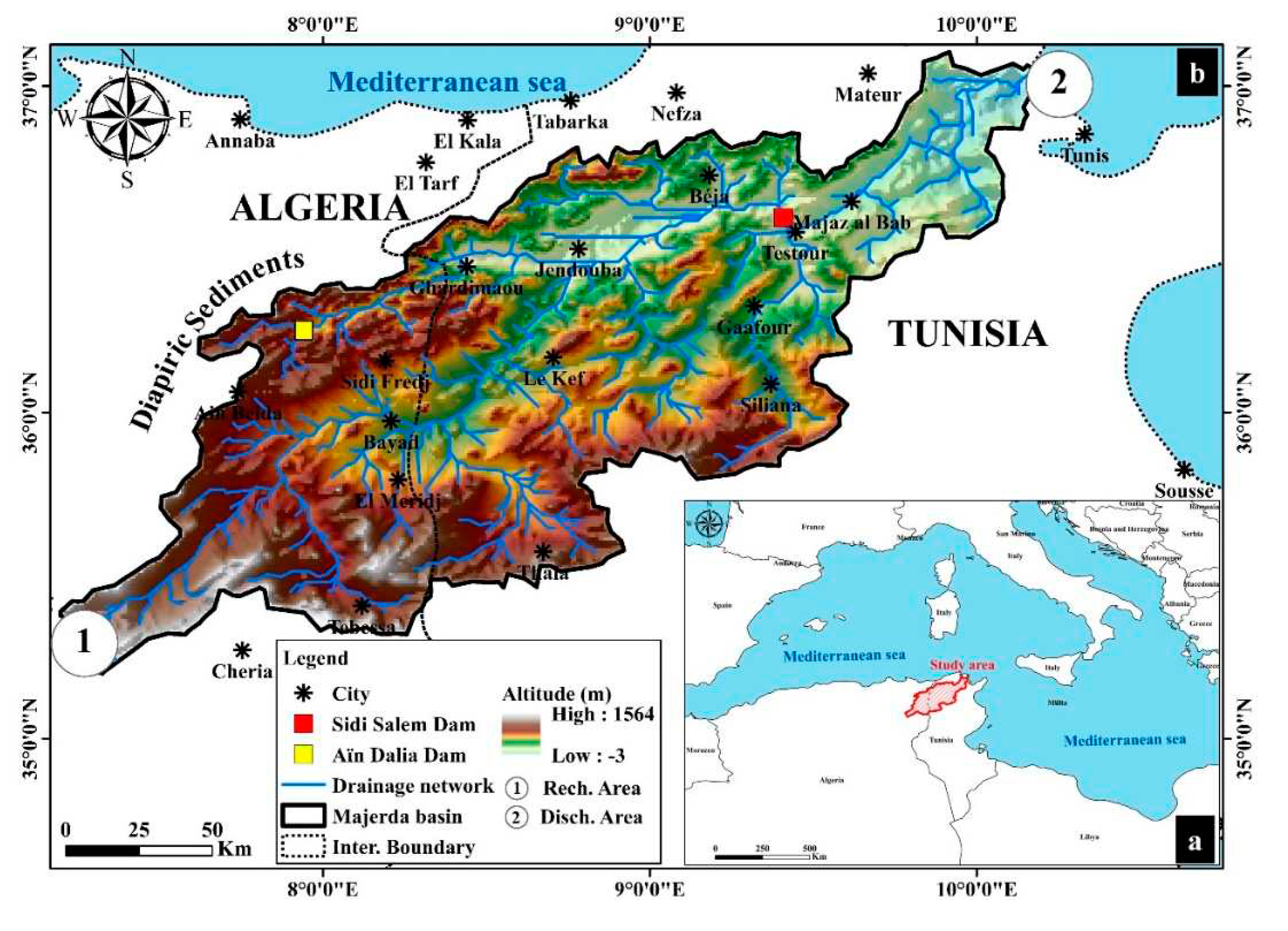
Figure 2.
Flowchart of the work methodology in the study area.
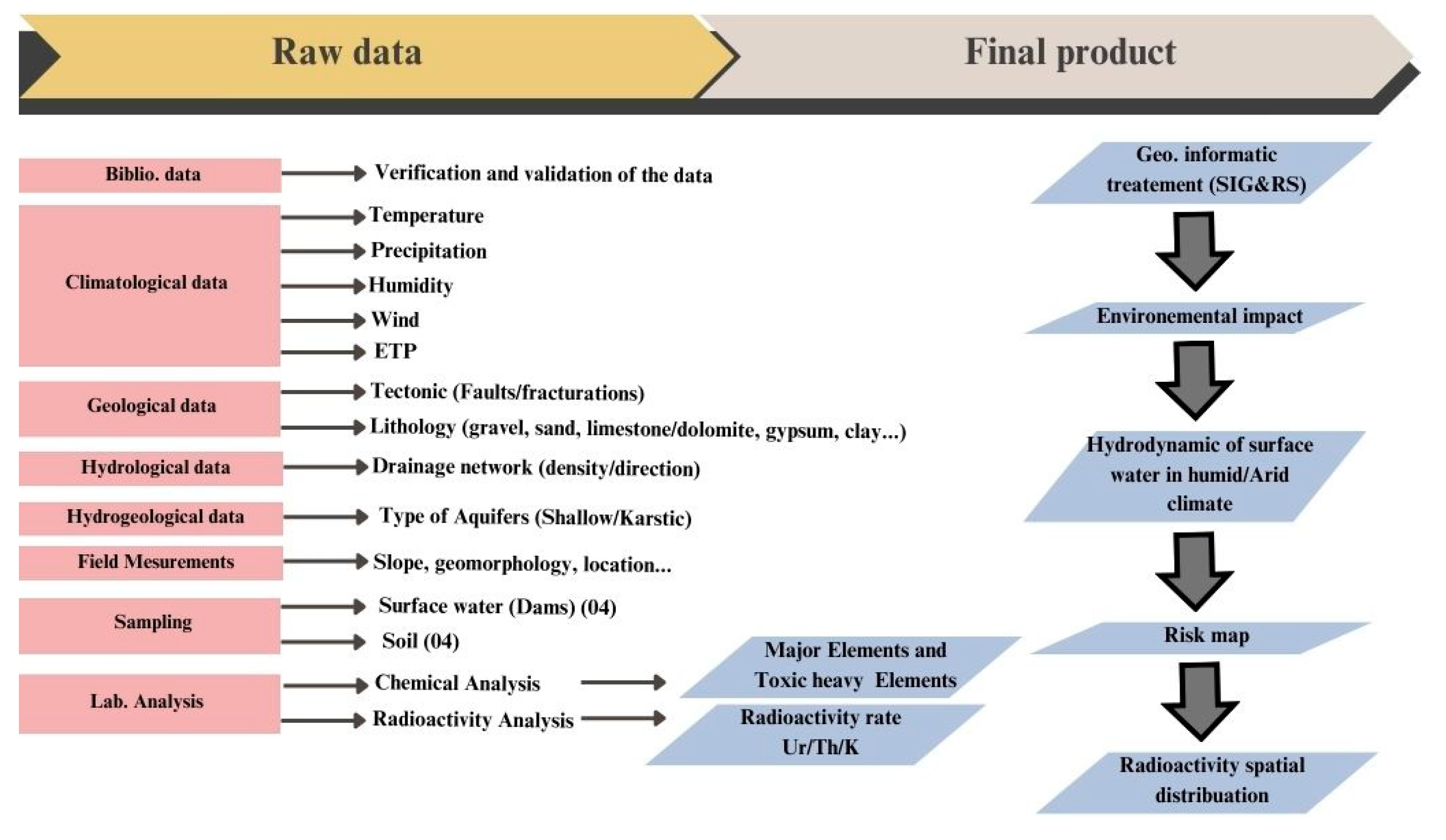
Figure 3.
The hydrodynamic of surface water in the humid climate.
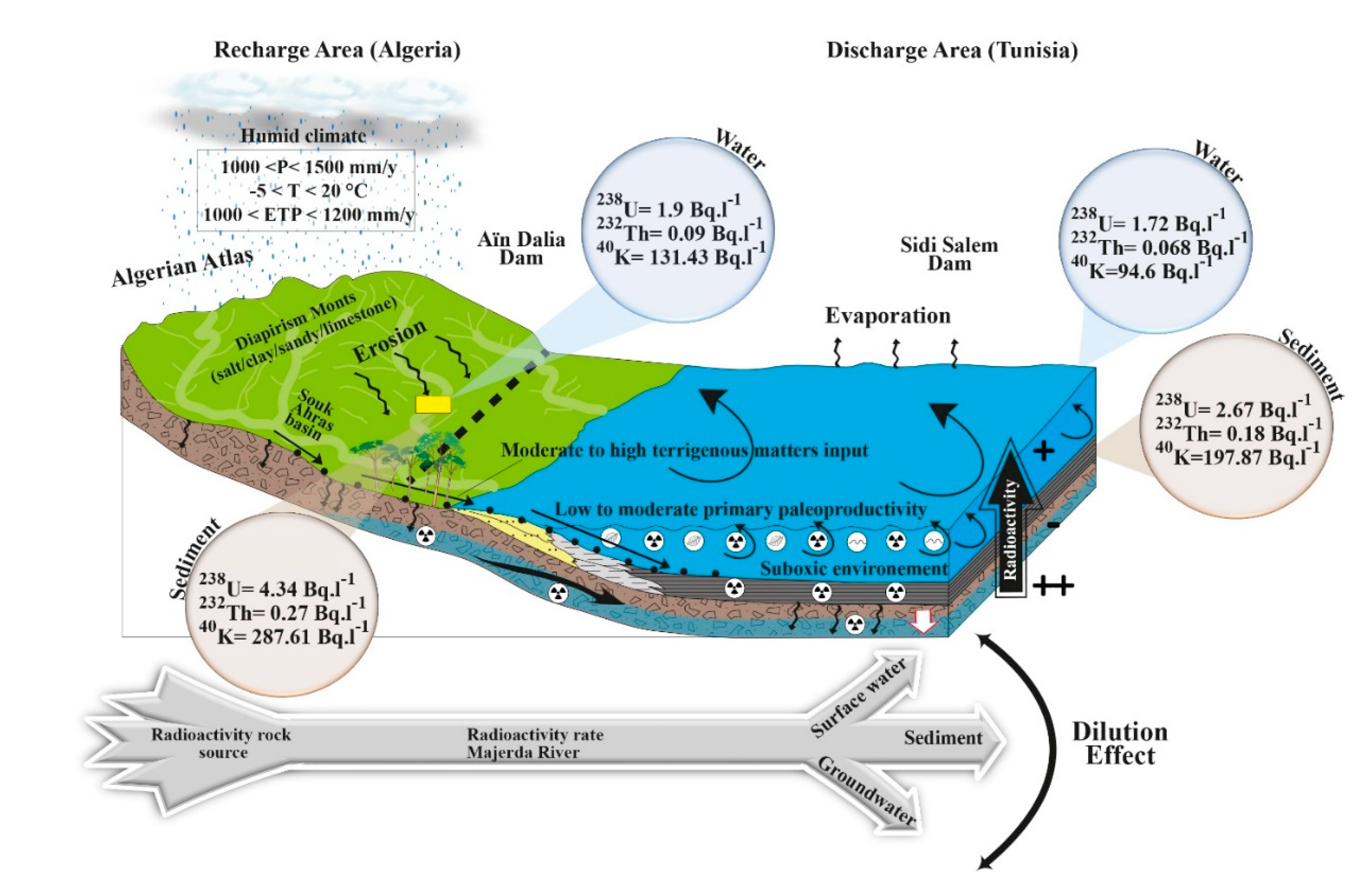
Figure 4.
The hydrodynamic of surface water in the arid climate.
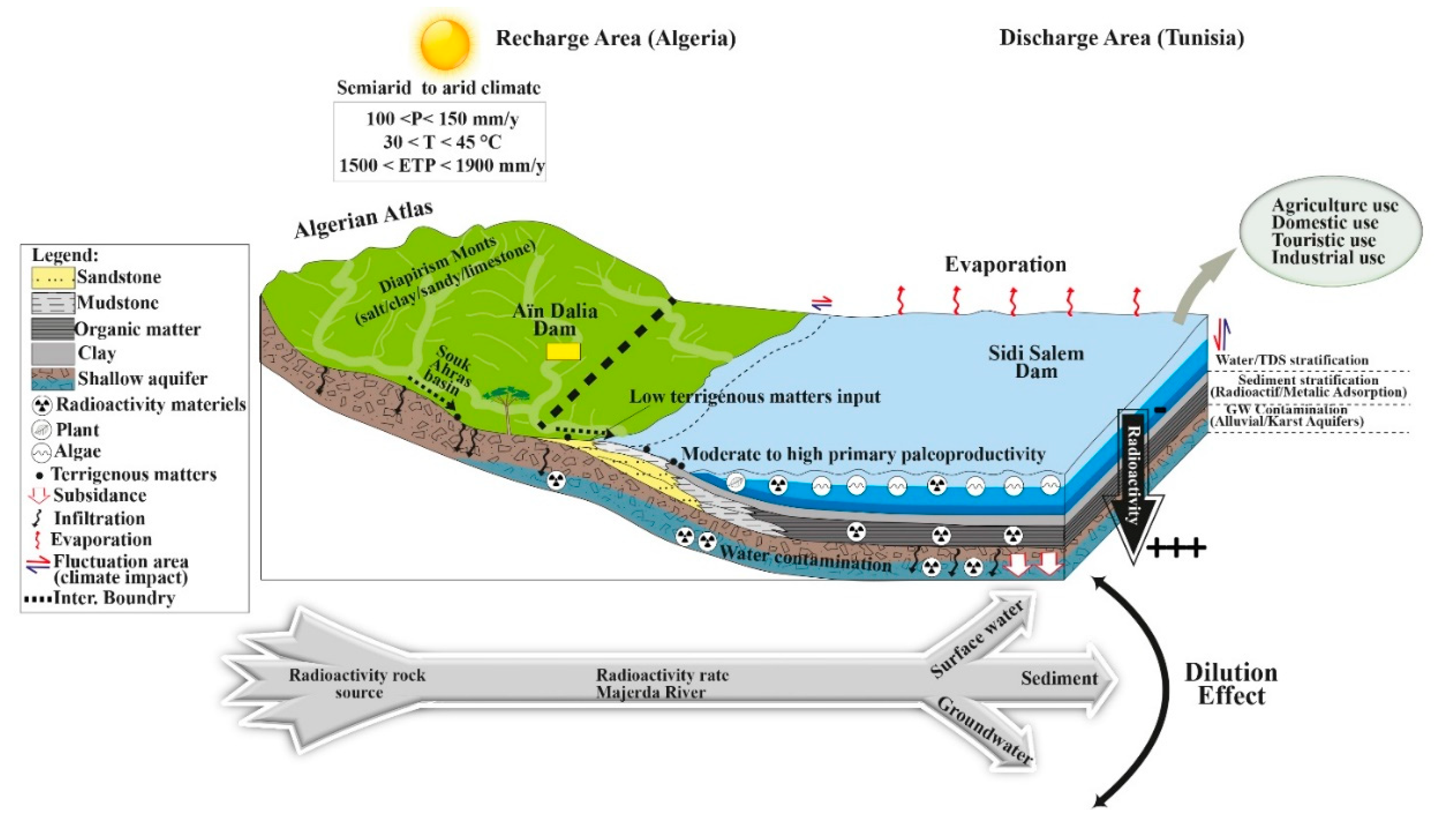
Figure 5.
a-Risk map of the radioactivity spatial distribution in the study area with the drainage network; b- Risk map of the radioactivity spatial distribution in the study area without the drainage network.
Figure 5.
a-Risk map of the radioactivity spatial distribution in the study area with the drainage network; b- Risk map of the radioactivity spatial distribution in the study area without the drainage network.
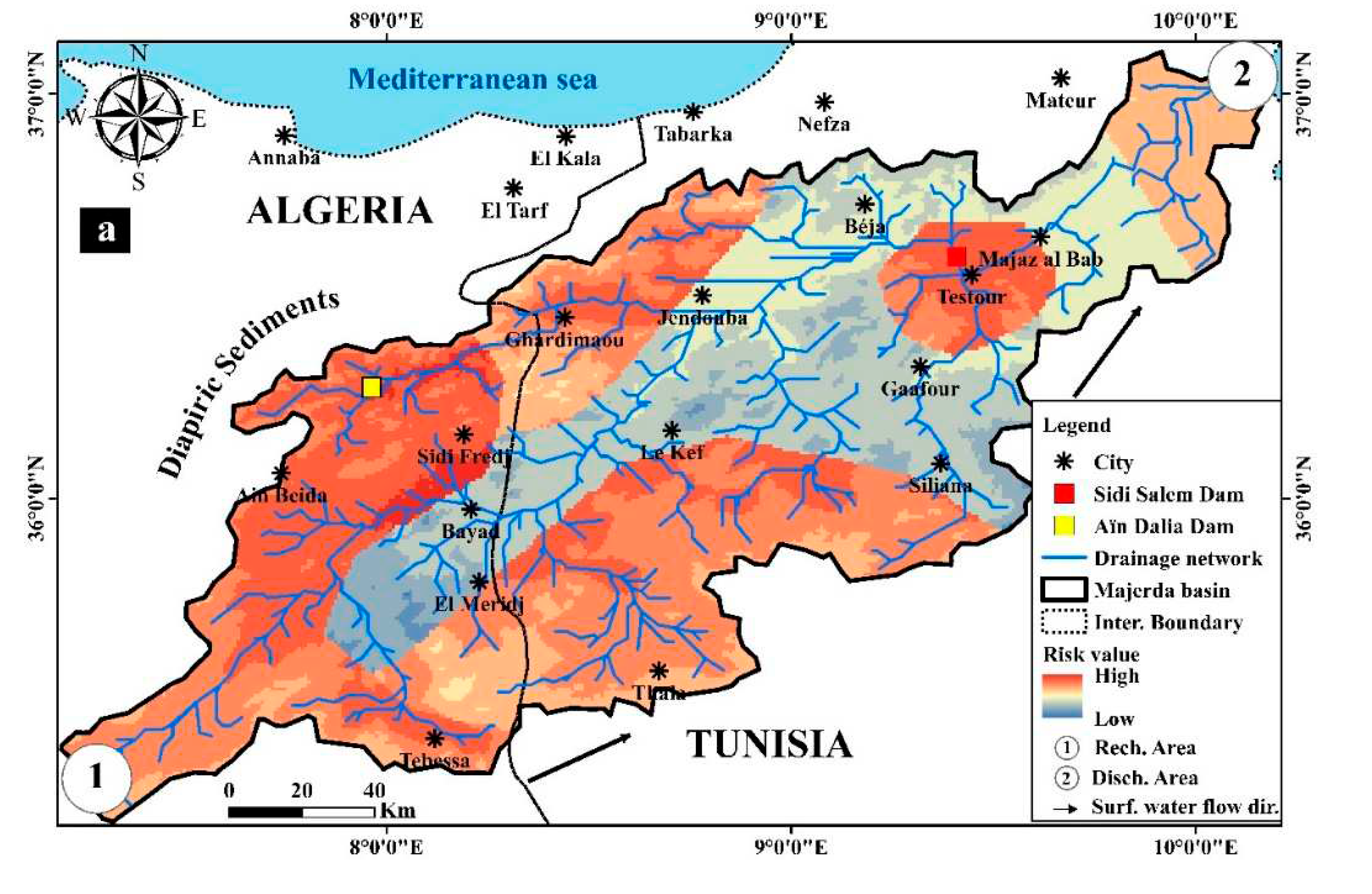
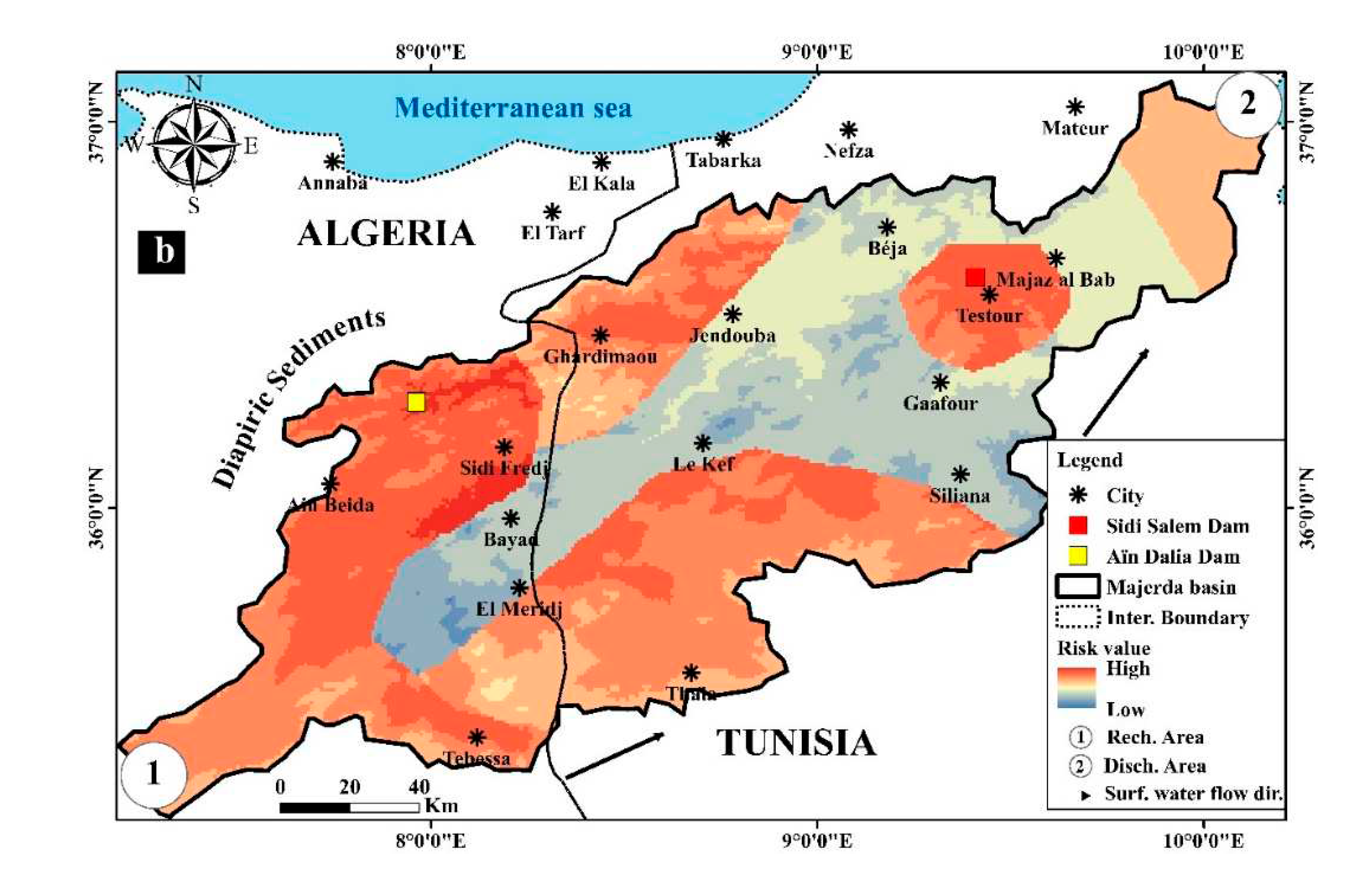
Figure 6.
Health risk map of the radioactivity impact in the study area.
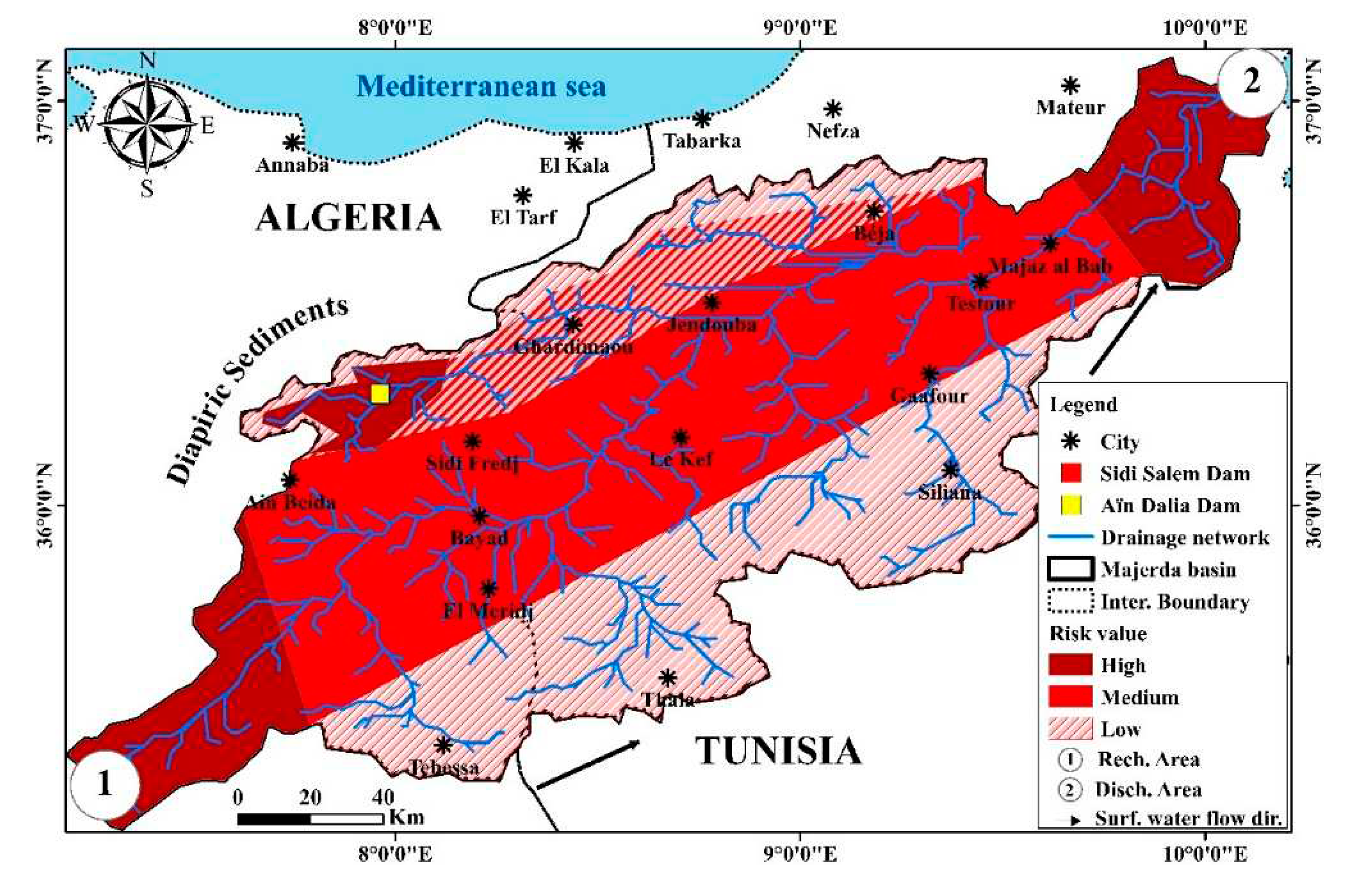

Table 1.
Estimated radiological parameters for the sediments.
| Location/country | D (nGyh-1) |
Raeq (Bqkg-1) |
Hext | Hint | AGED(μSvy-1) |
|---|---|---|---|---|---|
| Aïn Dalia dam/Algeria | 14.12 | 36.79 | - | - | 104.53 |
| Sidi Salem dam/Tunisia | 9.59 | 18.16 | - | - | 71.13 |
| World standard value [8] | 57.00 | 370.00 | 1.00 | 1.00 | 1.00 Svy-1 |
Table 2.
Total effective dose (HE) for surface water samples (Sidi Salem Dam Tunisia).
| Age Group | 0-1 | 1-2 | 2-7 | 7-12 | 12-17 | 17-25 | 25-45 | 45-65 | >65 |
|---|---|---|---|---|---|---|---|---|---|
| Upper side (mSvy-1) | 1.22 | 1.59 | 1.83 | 2.14 | 3.66 | 4.45 | 5.12 | 6.34 | 7.04 |
| Lower side (mSvy-1) | 0.84 | 1.09 | 1.26 | 1.47 | 2.52 | 3.06 | 3.76 | 4.12 | 5.02 |
| Word Standard value [8] | 0.12 mSvy-1 | ||||||||
Table 3.
Comparison of specific activity of 238U, 232Th and 40K with other studies from different parts of the words.
Table 3.
Comparison of specific activity of 238U, 232Th and 40K with other studies from different parts of the words.
| Region/Country | 238U, Bq kg-1 | 232Th, Bq kg-1 | 226Ra, Bq kg-1 | 40K, Bq kg-1 | Reference |
|---|---|---|---|---|---|
| Sidi Salem Dam (Water)/Tunisia | 1.72 | 0.068 | - | 94.6 | Present study |
| Sidi Salem Dam (Sediment) /Tunisia | 2.67 | 0.18 | - | 197.87 | Present study |
| Aïn Dalia Dam (Water) /Algeria | 1.9 | 0.09 | - | 131.43 | Present study |
| Aïn Dalia Dam (Sediment) /Algeria | 4.34 | 0.27 | - | 286.61 | Present study |
| Gafsa Phos.Rock/Tunisia | 702 | 75 | 911 | 90 | [6] |
| Tunisia | - | 29 | 821 | 32 | [26] |
| Egypt | 686 | 5.7 | 656 | 68.6 | [13] |
| Morocco | - | 20 | 1600 | 10 | [27] |
| Algeria | - | 64 | 619 | 22 | [28] |
| Saudi Arabia | - | 17-39 | 64-513 | 242-2453 | [24] |
| Germany | - | 15 | 520 | 720 | [27] |
| USA | - | 49 | 780 | 200 | [29] |
| India | - | 65 | 120 | 2624 | [28] |
| Jordan | - | 2 | 1044 | 8 | [26] |
| Kuala Lampur-Malaysia | - | 1.2 | - | 35.1 | [24] |
| Buruta-Nigeria | - | 26.9 | - | 61 | [23] |
| Oman | - | 2.26 | 20.49 | 44.83 | [30] |
| Kuwait | - | 6 | 36 | 227 | [31] |
| Iran | - | 17.61 | 14.96 | 361.6 | [32] |
| Turkey | - | 9.0 | 12.2 | 157.7 | [33] |
Table 4.
Specific Activity concentrations of 238U, 232Th, 40K and the toxic heavy metals (Fe, Pb, Zn, Ni, Cu, Cr, Cd) in dams’ surface water and sediments.
Table 4.
Specific Activity concentrations of 238U, 232Th, 40K and the toxic heavy metals (Fe, Pb, Zn, Ni, Cu, Cr, Cd) in dams’ surface water and sediments.
| 238U | 232Th | 40K | Fe | Pb | Zn | Ni | Cu | Cr | Cd | |
|---|---|---|---|---|---|---|---|---|---|---|
| Dalw2 | 1.90 ± 0.24 | 0.09±0.01 | 131.43±1.03 | 5.430 | 0.0980 | 0.087 | 0.024 | 0.063 | 0.015 | 0.025 |
| Dals3 | 4.34±0.05 | 0.27±0.05 | 287.61±3.34 | 201.9 | 5.88 | 5.046 | 0.216 | 0.441 | 0.06 | 0.20 |
| Dtnw4 | 1.72±0.01 | 0.068±0.01 | 94.6±1.04 | 9.700 | 0.065 | 0.061 | 0.018 | 0.043 | BDL1 | 0.130 |
| Dtns5 | 2.67±0.01 | 0.18±0.012 | 197.87±2.01 | 136.7 | 3.41 | 3.22 | 0.182 | 0.213 | BDL1 | 0.15 |
| WHO limits | 1.0 | 0.1 | 10.0 | 0.01 | 0.07 | 2.00 | 0.05 | 0.003 |
1 BDL: Below detection limit. 2 Dalw: Dam Algerian water. 3 Dals: Dam Algerian sediment. 4 Dtnw: Dam Tunisian water. 5 Dtns: Dam Tunisian sediment.
Disclaimer/Publisher’s Note: The statements, opinions and data contained in all publications are solely those of the individual author(s) and contributor(s) and not of MDPI and/or the editor(s). MDPI and/or the editor(s) disclaim responsibility for any injury to people or property resulting from any ideas, methods, instructions or products referred to in the content. |
© 2023 by the authors. Licensee MDPI, Basel, Switzerland. This article is an open access article distributed under the terms and conditions of the Creative Commons Attribution (CC BY) license (http://creativecommons.org/licenses/by/4.0/).
Copyright: This open access article is published under a Creative Commons CC BY 4.0 license, which permit the free download, distribution, and reuse, provided that the author and preprint are cited in any reuse.


