

Submitted:
09 September 2023
Posted:
12 September 2023
You are already at the latest version
Abstract
The efficiency success status of organization built environment assets management needs robust and comprehensive maintenance processes which depends on the efficiency of the contract information documents for the maintenance management within the assets life cycle and achieve positive return of the investments. Therefore, this paper highlights on the appropriate interactive approach to structuring information flow scope of the asset facilities management contract for construction projects based on GIS and BIM integration processes, sustainability standards, and As-built contractual documents of the project to support the organization owner and stakeholder to improve the asset management processes. Using expert interviews with comprehensive understand for the information type in several facility management contracts conducted in common Organization types based on reviewing available international facility management standards manual and contract of procedures for different services types, and required information flow inside international facility management firms. The study classify and build significant integrated information and data flow model contract drafting with measures and indicators of performance efficiency as guideline for monitoring, technically evaluating, and financially procedures for performance efficiency and quality of services provided in the facilities management contract for King Faisal University campus projects as a case study.
Keywords:
Asset management
; Sustainability management
; Geographical information system
; Building integrated modelling
2 Architecture and Urban Planning Department, Faculty of Engineering, Port Said University, Port Said 42526, Egypt
1. Introduction
The organizations needs to maintain, and develop the agreed services which improve the effectiveness of its primary activities, Life Safety, and reduce maintenance costs by 3.3% under integration of processes of the facilities management FM platforms [1,2]. The relationship of facilities management FM market which represents about 5% of global is consider horizontally oriented to the human resources, information technology, real estate functions, and organization assets [3,4,5]. The of Facility management FM scope include all internal and external of built environment [6]. Facility management FM applications include several disciplines, and integrate people, place, process, and technology to enhance and improve the built environment in the, safety, comfort, and functionality efficiency manner [7].
Facilities management in construction projects is resource for strategic direction by providing applications to maximize value and minimize cost, provides services to maintain the environment and sustainability, and supported by both local and large international associations i.e., IFMA, to support facilities issues as example track changes, identify risks, take corrective action [8,9].
FM scope focus on the strategic and daily operational objectives to maintain the built environment in safe and efficient environment as outsourcing services include maintenances and operation in integrated supply contracts [10,11]. Facilities management is an interdisciplinary activity include estate strategies, asset spaces, renovation, and refurbishment management. As well as retrofitting master planning information provision, transport maintenance, sustainable cleaning. [12,13,14]. The facility management include all the integrating activities in the asset contract management [15].
BIM building information modelling identified as interactive approach to design, construct, run, and maintaining the building project using digital modeling to provide better design visualization and digital simulations from designing to operating the construction projects. BIM support preventive maintenance scheduling and system to develop information approach about the asset construction disciplines i.e., structure discipline (walls, roofs, floors, etc.), mechanical discipline, electrical discipline components by collecting the required information and computerized maintenance management System in MMS, GTB, BMS, BMS, EAM or ERP as building management system [16,17]. Geographic information system GIS is robust information system using data and software to manage facilities, allowing them to analyze data and metadata to make better decisions for improving performance management [18]. GIS supports analytical capabilities applications to facilitate workflows in managing internal and external buildings infrastructure and provide full operational awareness throughout the facility life cycle [18,19].
The study opens gate for various studies on the asset quality value and facilities management assessment information flow in construction projects processes as a practical approach to vital contract management. Therefore, the main research questions are: what is the proper software support gathering facility management information? How to manage the analysis of collecting the study data for facility management contract? What are the benefits of supporting decision-makers in construction management in asset and facility management field?
2. Materials and Methods
2.1. Asset Facility Management in Construction Projects
Facility Management FM has several definitions could be presented as follows: A) All required services to manage and maintain the buildings to increase its value.'' B) supporting the project maintenance management during the life cycle of building. C) The multi-disciplinary activities integration within the built environment to control their influences upon workplace and people. D) support services for the organizations with professional management procedures focus on the efficient and effective deliverables (E integrates people, place, process and technology within the built environment in organizational functions to improve the people and the productivity life quality [10,11,12,13]. Facility management FM programs and courses is high concern in universities and specialist organizations which design and launch a lot of specialist accreditations, programs, courses, for people and buildings [14,15,16].
Asset is an item, thing or entity that has potential or actual value to an organization and may be fixed, mobile or movable. It may be an individual item of plant, a system of connected equipment, a space within a structure, a piece of land, or an entire piece of infrastructure or an entire building or portfolio of assets.'' The context, ''value'' can be tangible, intangible, financial or non-financial and can vary throughout the life of the asset [17,18]. While Types of asset is: Human assets., Information assets, Intangible assets, Financial assets, and Physical assets which include plant, machinery, property, vehicles and other items that have a distinct value to the organization including any software code that is critical to the delivery function of the asset [18,20]. The term asset refers component to the whole building, element, system, sub-element and/or specific asset. Asset classifications can be portfolio, estate level (e.g. offices and schools), down to specific maintainable assets (e.g. boilers). NRM3 applies to all levels of building or constructed assets that are applicable to maintenance and life cycle major repairs and replacement work.[19]. Asset as an item, thing or entity that has potential or actual value to an organization and suggests that an asset may be fixed, mobile or movable. It may be an individual item of plant, a system of connected equipment, a space within a structure, a piece of land, or an entire piece of infrastructure or an entire building or portfolio of assets[17,20]. Built asset is defined as or Built infrastructure e.g. roads, railways, pipelines, dams, docks, etc. that are the subject of a construction project or where the asset information is held in a digital format. [21]. Built asset is defined as building, multi buildings (e.g. a site or campus), or built infrastructure e.g. roads, railways, pipelines, dams, docks, etc. that are the subject of a construction project or where the asset information is held in a digital format [17]. Facilities management is the integration of processes within an organization to maintain and develop the agreed services which support and improve the effectiveness of its primary activities, and also it is concerned with the management of facilities at both a strategic and a day-to day level to deliver operational objectives and to maintain a safe and efficient environment [22]. Asset management is defined as the process of developing, operating, maintaining, upgrading, disposing of an asset using the most efficient and effective means, and provides a further overlay to Facilities Management, formalizing the maintenance regimes for the building[23,24]. In 2017, several FM organizations and individuals came together with a common goal to elevate the facility management profession and advance the careers of facility professionals, resulting in the creation of the sessional Facility Management Institute. The foundation of the FM credential is the FM Body of Knowledge, which defines the 19 functional FM knowledge areas and five cross-functional competencies required of today's facility professionals. This body of knowledge is the result of an extensive 2017 research study led by FMI and the FMI Commission with input from over 3,300 professionals spanning 93 countries. The five cross-functional competencies in the FM Body of Knowledge: communication, sustainability, quality, collaboration, and innovation. These competencies describe the behaviors, attributes, and underlying knowledge necessary for FM professionals to facilitate the application of core technical knowledge and skills, the 19 functional FM knowledge areas and five cross-functional competencies focus in Communication, Sustainability, Quality produces, Collaboration, , and Innovation, as shown in Figure 1 [25].
The main FM Knowledge Domains principles of FM Clients and Professionals [26,27] include: Professional competence through lean practice Service Products and dependability driven quality services processes to be a competitive advantage for clients. Second, Sustainability-oriented resources efficiency with effective services procurement and provision through the lifecycle in suitable practical actions. Third, Keys and booking system, Security, Fees and pricing, Hours of operation, and Programming. Fourth quality, safety, and asset maintenance plan fifth, Multiple-use with Management agreements. Sixth, Provided strong justification according to standards, e.g., BS 6079-1:2010 Project management – Principles and guidelines for the management of projects (BSI, 2010), RICS facilities management standards – core principles (RICS, 2012), and ICE's Guiding Principles of Asset Management (ICE, 2013).
Facilities management is divided into two basic areas: Hard Facilities Management (Hard FM) and Soft Facilities Management (Soft FM). Hard FM deals with physical assets such as plumbing, heating and cooling, elevators. Soft FM focuses on tasks performed by people such as custodial services, lease accounting, catering, security, grounds keeping [28]. FM covers these two main areas: The first refers to the physical built environment with focus on work in space and building and infrastructure e.g. planning, design, workplace, construction, lease, occupancy, maintenance and furniture, The second refers to people and organization e.g. catering, cleaning, ICT, HR, marketing, and hospitality. These two broad are commonly referred to as "hard FM" and "soft FM". The second covers the people and the organization and is related to work psychology and occupational physiology. [29,30]. The International Facility Management Association (IFMA) launched an updated Global Job Task Analysis (GJTA) initiative to determine most important roles and responsibilities for modern-day facility management based on 62 countries responses of facility managers, IFMA established 11 core modern facilities management competencies and updated terminology and expanded responsibilities, knowledge, skills and abilities comprise the full scope of facilities management as follows[31]:
- Leadership and Strategy field illustrate how to align the facility's strategic requirements with the entire organization's requirements, and Lead, inspire and influence the facility organization.
- Operations and Maintenance field illustrate how to manage/oversee the acquisition, installation, operation, maintenance, occupant services, and monitor the usage and performance of all facility systems, equipment and grounds.
- Finance and Business field in how to develop, recommend, manage and oversee the facility’s (expense, operational and capital).
- Sustainability contain manage/oversee the entire organization's commitment to sustainability through life cycle process,
- Project Management define program projects (purpose, size, scope, schedule, budget and user needs).
- Occupancy & Human Factors include how to create a healthy and safe environment that is conducive to innovation, and provide security that meets the facility's needs
- Real Estate field in how to manage/oversee the real estate portfolio.
- Facility Information Management & Technology Management field to align facility management technology with organizational information technology and evaluate, implement and operate integrated workplace management systems (IWMS).
- Develop risk management and emergency management plans and procedures field.
- Manage a facility management communication plan.
- Develop and review performance metrics for facility management services, and audit and document compliance with codes, regulations, policies and standards
2.2. Facility Management Systems, Software and Metrics
Enterprise Facility Management Software is a leading IWMS / CAFM / FMS solution that competes with world-leading products in IWMS / CAFM / EAM / CMMS space. It is a contemporary solution that works together with businesses to provide a complete perspective on facilities operation by bringing together space, people, assets and maintenance into a single system [32].
Facilities management also refers to facilities management systems and software. Vast amounts of data - often called Internet of Things (IoT) data - are generated by built environments through sensors, meters, gauges and smart devices [33]. According to many factors, including ease of use, flexibility, scalability, and the selection of features there is 20 software solutions like Hippo CMMS, Prod smart, FMX, Quick Base, ServiceNow Facility Management, iLab Core Facility Management, CBRE, Service Insight, Nexudus Spaces, Skedda Bookings, Office Space Software, AiM Space Management, ARC Facilities, Infraspeak, 360Facility, WebCheckout, ARCHIBUS, Rosmiman IWMS, RecTimes, WebTMA, these software can allow to access up-to-the-minute data to space management, move tracking, facility maintenance, asset tracking, security and visitor tracking, mailroom management systems. Facilities managers need to track data about all processes and operations to be certain they are making the best determinations, based on the most accurate information. to outline the specific measurements every facilities professional must collect, understand, and track, including real estate costs and terms, space utilization, real estate costs, everything about every asset, the facilitiesteam's performance, sustainability goals, optimal space use and the quality of space. The metrics used to achieve that is as follows: Sustainability Goals, Maintenance Costs, and Productivity Costs [34,35].
According to Esri, a geographic information system (GIS) is a framework for gathering, managing, and analyzing data. Rooted in the science of geography, GIS integrates many types of data. It analyzes spatial location and organizes layers of information into visualizations using maps and 3D scenes. With this unique capability, GIS reveals deeper insights into data, such as patterns, relationships, and situations—helping users make smarter decisions [36]. Using GIS can build a data model that includes geographic layers (such as soils, geology, and vegetation), built layers (such as land use, buildings, highways, and infrastructure), and social layers (such as social data and code requirements) [37]. GIS is considered Resources for Facilities Management Users, whether it has GIS-CAD-BIM Data Interchange, ESRI's ArcGIS family of products supports many CAD data formats and OGC, Inc., Web services including WFS, WMS, and WCS, and Building Interior Space Data Model (BISDM) [38]. Building Information Modeling (BIM) is an intelligent 3D model-based process that gives architecture, engineering, and construction (AEC) professionals the insight and tools to more efficiently plan, design, construct, and manage buildings and infrastructure. Integrating BIM with facilities management software systems is the Holy Grail in terms of better quality and standardized data because information stored within BIM includes schedules and blueprints as well as asset information such as cost, location, service life, carbon impact, maintenance, spares, re-ordering, substitution, serial number, warranty details and more[39,40]. The operational phase requires comprehensive set of well-structured information regarding the building asset. Therefore, a BIM model filled with the multifarious information can be integrate with existing FM systems, contribute in optimizing the processes conducted conventionally within the FM practice. Support sustained information flow for the efficient operational stage, avoiding performance gap by offering efficiencies in the information management across the building asset lifecycle. Furthermore, BIM as a collaborative process that facilitates the sustained logistics of information is introduced as viable way [41]. BIM contribute in information flow for some application area for FM like: mobile localization of building resources, digital asset with real-time data access, Space management, Renovation/retrofit planning and feasibility studies, Maintainability studies, Energy analysis and control, Safety/emergency management [42]. The success of integrating these two domains (GIS and BIM objects) is a great achievement toward solving problems in Architecture, Engineering and Construction (AEC), Facility Management (FM), Disaster Management (DM) sectors [41,42]. Because it will be able to subscribe to access GIS information layers within software such asAutodesk's Revit. This includes real-time specialization data from the Internet of Things. The integration of data through geographic information system (GIS)-based building information modeling (BIM) has recently emerged as an important area of research. Several studies have investigated the benefits of the effective integration of BIM and GIS. This process generally involves the extraction and transformation of information required by each stakeholder in the relevant project. GIS and BIM are similar in that they both model spatial information — the former is used for outdoor modeling and the latter for indoor modeling — and have common use cases, such as location-based municipal facilities information queries and management. In order to realize use cases based on BIM and GIS, effective interoperability between GIS and BIM should be supported by an appropriate platform. Data and workflow integration across GIS and BIM enable to realize greater efficiency, sustainability, and habitability of the cities, campuses, and workplaces all around us [42,43]. Integration GIS/BIM support to build a robust context model where geographic information and infrastructure design data are brought together, helping to better understand how assets interact within the context of a real place and geography, And to deliver more, better, with less, the industry needs to think about things differently. Integrating BIM and GIS can result in workflows that move data seamlessly from one system to another [43]. By using Facilities Management Information and Data Exchange models in the building industries like IFC Industry Foundation Classes, COBie Construction Operations Building Information Exchange, and GBXML Green Building XML schema. These models contain a structures combination of geometric and non-geometric data. This data can be displayed, analyzed and modified in different ways in multiple software applications. Using LOD (BIM's Level of Detail) 500 As Built documents (Elements are modeled as constructed assemblies for Maintenance and operations. In addition to actual and accurate in size, shape, location, quantity, and orientation, non-geometric information is attached to modeled elements) [44,45,46]. Figure 2 illustrate integrating BIM and GIS to make workflows data seamlessly with using data exchange between as built information document and potential BIM lifecycle and GIS solutions for facility management [46].
Project management is the use of skills, knowledge, and tools and techniques in overseeing all activities related to a project. The projectmanager's role is to ensure that the stated objectives of the project are achieved. Project management processes fall into five groups: Initiating, Planning, Executing, Monitoring and Controlling, Closing. Project management knowledge draws on ten areas: Integration, Scope, Time, Cost, Quality, Procurement, Human resources, Communications, Risk management, Stakeholder management, while The project management information system PMIS is part of the environmental factors, provides access to tools, such as a scheduling tool, a work authorization system, a configuration management system, an information collection and distribution system, or interfaces to other online automated systems. Automated gathering and reporting on key performance indicators (KPI) can be part of this system [47].
Central Building Management System BMS is a system to facilitate advance control providing automatic monitoring of all systems, equipment, machines, and devices through field controlling units and a workstation in the control and monitoring room of each building, allowing for faster operation and monitoring of all systems, equipment, machines, and devices available in all buildings and support facilities of the university campus [48]. Figure 3 illustrate BMS scope in construction project. Supervisory control and data acquisition SCADA is a system of software and hardware elements that allows industrial organizations to: control industrial processes locally or at remote locations, monitor, gather, and process real-time data, directly interact with devices such as sensors, valves, pumps, motors, and more through human-machine interface (HMI) software, record events into a log file, help to maintain efficiency, process data for smarter decisions, and communicate system issues to help mitigate downtime[49]. Figure 4 illustrate BMS scope in construction project.
2.3. Methodology
Conducting comprehensive facility management contract document information matching with organizations' needs and requirements after final handover projects to be launched for bidders is a severe concern. The study conducted a complete analysis to support the KFU client in the case study using expert interviews for three main; First: resources a comprehensive Facility management contracts and Organization types, Second: the facility management international firms' scope, and the analysis for existing KFUFM contracts, Third: analysis for existing KFUFM contract to establish integration asset information model management AIMM. The study was conducted in the period between 2020 and 2022 in the Saudi Arabia region in a desert university campus case study focus on analysis for the required document information flow and scope with in-depth details in method and procedures.
2.3.1. Facility Management Contracts and Organization Types
Typically organizations of facilities management services can be provided by three layers; Strategic Layer: to define the strategy objectives or direction, and making decisions, Tactical Layer: to acts as a delivery vehicles to meet the strategic objectives, and Operational Layer: to utilize the capabilities delivered by projects and programs [50,51]. At early stages for any construction project, owner with his engineer or consultant prepares necessary documents for tender process which will be included in the contract. These documents are called contract documents include: General conditions, Special conditions, Drawings and specifications, B.O.Q (bill of quantity), Letter of acceptance, and Contractor bid [52]. There is Seven contract types into three larger groups of contracts: First: fixed-price (Firm Fixed Price (FFP), Fixed Price Incentive Fee (FPIF), and Fixed Price with Economic Price Adjustment (FP-EPA), Second: cost-reimbursable Cost-reimbursement Contracts, Cost plus Fixed Fee (CPFF), Cost plus Incentive Fee (CPIF), and Cost plus Award Fee (CPAF)), Third: Time and Material Contracts (T&M) [53].
Typically, FM might be split into two areas of ''hard'' and ''soft'' services. The hard services relate to the actual fabric and building systems and might also be considered as the more traditional PM services. The soft services relate to the nature of environment culture of people and organizations. Typically, there are five models for delivering FM services can be illustrated as follows [54]: A) In-house FM department mean that the organization has its own dedicated management team and in-house employees to deliver all FM services. Some specialist services, where there is no expertise in the company as illustrated in Figure 5; B) Out-tasked service contracts where an organization has an in-house team of FM professionals who procure and manage a series of outsourced contracts as illustrated in Figure 6.; C) Outsourced managing agent FM contract In this scenario the organization will outsource most or all services on contracts and will appoint a FM company as managing agent to manage these contracts on their behalf as illustrated in Figure 7; .D) Outsourced managing contractor FM contract structurally this is similar to outsourcing on a managing agent contract but a step further whereby the FM supplier will deliver services to the client organization through a mixture of their own resources and a series of sub-contracts. Total Facility Management TFM contract is a development on the managing contractor option whereby the FM supplier will through strategic partnerships, joint ventures, subsidiary companies or in-house resources, deliver all or most FM services to the client organization.
2.3.2. Facility Management International Firms’ Scope
One of international facility management scope for higher education sevice and facility management framework could explaind as follows [54,55]:
- (a)
- HVAC & MEP Maintenance (American Society Heating refrigeration and Air Condition Engineers (AHSRAE), SFG20 Guidelines & Standards, APPA Maintenance Standards and OEM recommendations.
- (b)
- Cleaning Services Housekeeping services, incompliance with BICSc Standards, & APPA Custodial Standards, & material cleaning as per specifications.
- (c)
- Laundry Services, Risk Analysis Biocontamination Control standard.
- (d)
- Security Services, ISO 18788:2015 & as per local requirements, law and regulations.
- (e)
- Waste Management & Shredding Services, Standards/guidelines in line with local regulation.
- (f)
- Pest Control Services, National Pest Management Association Guidelines & Standards.
- (g)
- Catering & Hospitality Services, Hazard Analysis and Critical Control Points (HACCP) Standards & ISO 22000, Performance Management.
- (h)
- Office Support Services (Mailroom, Porter & Reception Services) As per Facilities requirement.
- (i)
- Landscaping & Grounds Maintenance, APPA Grounds Standards Professional Grounds Maintenance Society standard.
- (j)
- Specialized Vendor Management for Critical Key Assets (UPS, Air Compressors, etc.) As per OEMs/Manufacturing Guidelines & as per local laws & regulation.
- (k)
- Third Party Testing & Certification (Frequencies are defined by statutory requirements such as; Elevators, BMU and Water Testing– Bi Annually, Air quality tests – Monthly and Sewage Tank – Quarterly)
- (l)
- Transportation & Fleet Management (As per Facilities & in country requirement).
- (m)
- Energy Management ISO 50001 – Energy Management System Certification; energy performance indicators (EnPI).
2.3.3. Analysis for Existing KFUFM Contract
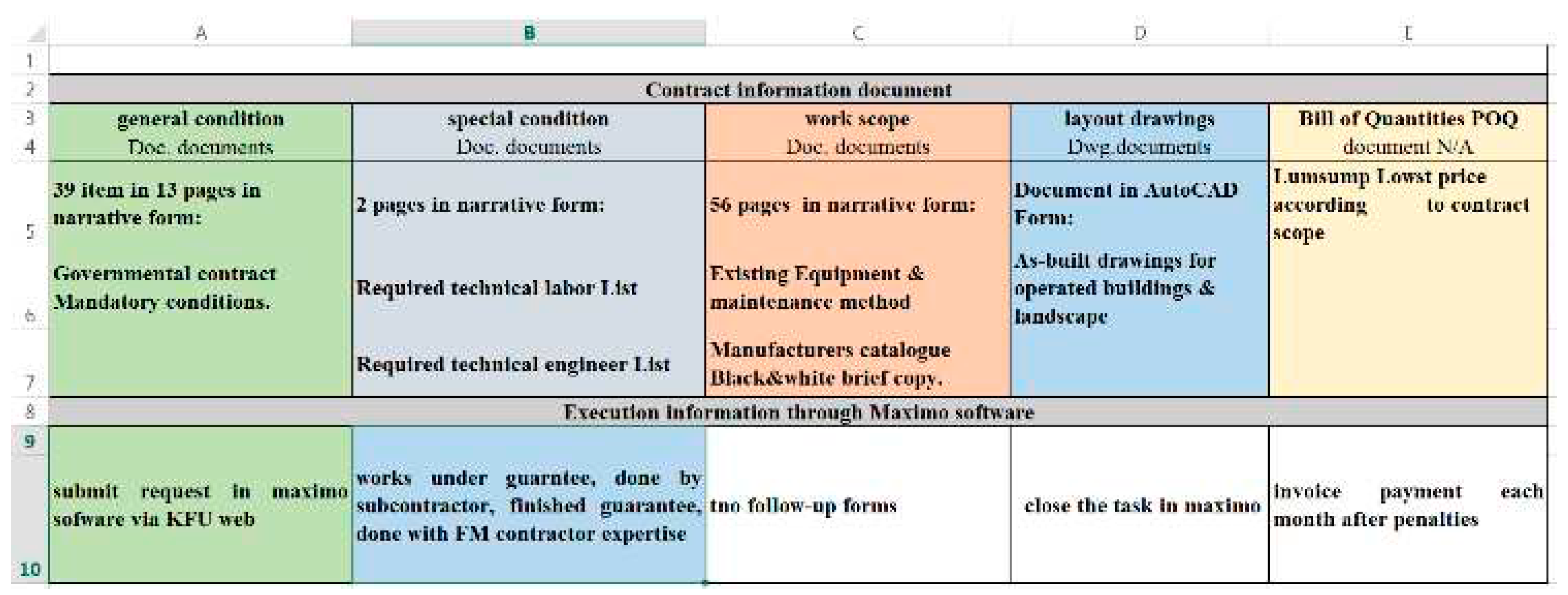
The facilities and asset management contract in the King Faisal University project, one of the huge projects that serves about 35,000 students, 1500 faculty and administrative members on an area of 4.5 km2, which contains 76 academic, service and administrative buildings, 270 villas, and 24 residential buildings in operation. This represents about 75% of the total size of the project without adding future areas, this is in addition to the general site areas of open and shaded spaces under operation, which currently represents about 80% of the total project size for the infrastructure includes future areas. The information of king Faisal university facility management contract KFUFM include the following First: paper document include main items: a) general condition; b) special condition; c) work scope contains: required maintenance/type of equipment with manufacturer catalogs; d) layout drawings. Second: the approved procedures submittals for the company which responsible to make the facility management execution for daily routine work, or responding for the spaces occupants call. Table 4 illustrate the available information for the main items with its sub-items for the existing KFU facility management contract. The way to execute and monitor KFUFM with the assigned company for the routine work depend on offer number of labors, equipment, and tools to the following work [56,57]:
- -
- cleaning the internal and external spaces and its fixed and mobile furniture component is under company foreman realization.
- -
- equipment error repairing for the building or layout with under call procedure only, that mean if any one call about something wrong in the equipment they will fix it.
This contract type have several disadvantageous in information scope as follows:
- -
- Un precisely account list for the fixed and mobile furniture, as well as, its right locations
- -
- There is no FM Classification for the procedure, tools, and schedule for each internal and external entity and spaces.
- -
- No approved checklist form based on certain information to monitor the FM procedures between the representative client technical teams and company part.
- -
- The contract scope information itself not classified to divisions to be monitor from the right specialist and also support KFU to hire the specialist for each division.
3. Results
The organization's asset management needs to plan and build in their construction projects the quality of the contact information for the facility management, which continually affects the performance and monitoring procedures quality within the project operation lifecycle. The facility management information contains buildings, spaces, equipment, devices, and layout infrastructure items to ensure the benefits return of investments spent and improve the health and end user fitness quality. This study is based on the integration of GIS, BIM, BMS, SCADA software, extensive interviews with experts an interactive asset management contract model AIMM has been built, include comprehensive information flow for facility maintenance management for King Faisal University KFU campus with areas 4.5 km2. This model can accurately reflect on the financial and technical aspects, containing all the details as an integrated information guide appropriately with the company's expertise and international standards specialized in this field. Applying this model in King Faisal University achieved significant findings through five consecutive phases: Initializing, Planning, execution, monitoring, controlling, and closing that contain totally 23 items as input information, 13 Item as tools and techniques to analyze the information, 23 items as output information, accordingly. The scope of the eight facilities management operation was thus selected: HVAC & MEP Maintenance, Cleaning, Security, Waste Management & Shredding, Pest Control, landing & Garden, Specialist Vendor Management for critical Key Assets (UPS, Air Compressors, etc.), Energy Management (Lighting fixtures, fire Testing, Boards, BMS Management. The technical information structure extracted for these eight areas has been formulated in six engineering discipline: Architecture, Civil, Mechanical, Electrical, Layout, and furniture covers the technical services to locate them correctly represent an integrated and comprehensive information structure as a manual guide in six main contract documents: General conditions, Special conditions, POQ with divisions, spatial and detail drawings with ArcGIS+BIM Software, execution &moitor information which include: FM execution method information, FM periodical method information, FM preventive method information and FM daily method information Maximo software protocol contain:POQ+DWG's and monitoring with BMS/SCADA. These contract documents contain full official obvious submittals, procedures and forms for work scope, Monitoring &followup and Financial for each scope aspect, which, enable to determine the proper number of the labor, responsibilities distribution, the equipment test list, the necessary tools and the number of hours of work required to be provided to suit each service field scope and implementation method; It also ensures that the facility management authority will be able to monitor the efficient performance of the contract areas of financial control regulation, payment invoices and penalties number in FM execution Method Information, FM Periodical Method Information, and FM Daily Method Information; in such a way that are not subject to personal effort.
Therefore, the study proposes enhancing approach for the required information flow for facility management FM structure to rectify the contract items, as illustrated in Figure 10 which explain this flow of essential and needed information to build Asset Information Model Management (AIMM) process and stages to obtain applicable, robust, comprehensive, and practical facility management contract. This model compatible with international standard in FM, using available and latest software e.g.REVIT in BIM and ARGIS10.2, comprehensive analysis from client, experts, and stakeholders requirements, divided by project management processes. This AIMM model concept include and as illustrated in Figure 8 Stages in five steps, scope for eight aspect, divisions for all project disciplines, seven documents.
The study follows the project management best practice [56] to obtain the necessary information to build the AIMM model with engagement for all stakeholders, suppliers, manufacturers, technical team, end user recommendations, and client committee. Table 6 illustrate details for the main five processes to build AIMM model as follow:
- (a)
- Initiating process with six input items, three tools and technics, and the output for general information in three items.
- (b)
- Planning Process with eight input items, using Hyperlink between the main five Campus Information documents, tools and technics in five items, and the output for Primary Information document in four items.
- (c)
- Executing process with a Primary Full Information document and five items as input items, using BIM/GIS integration as tools and technics, and output for FM contract will be main four items include FM Agreement document, Comprehensive information contract document., Contract Scope with Final complete electronic As built Information documents and Schedule time
- (d)
- Monitoring & Controlling Process with two items as input items, two items as tools and technics, and FM Monitoring and controlling forms as output in nine items.
- (e)
- Closing Process with two input items, two items as tools and technics, and the output for general information in three items include List of Bidder invitation Bidding document:, FM Agreement document, and FM Monitoring and controlling forms.
There are more than 15 international standard service within hiring firms can any organization apply it in its asset management, the study with using the previous stage define the required services and collect all information needed and classified into: HVAC & MEP maintenance, Cleaning, Security, Waste management & shredding, Pest control, Landscaping & garden, Specialist vendor management for critical key assets (UPS, Air compressors, etc.), Energy Management (Lighting fixtures, Fire detecting, Boards, etc.), the required information gathered from specific materials/system suppliers, specific manufacturers and lesson learned from stakeholder involved in KFU asset management. The information include: method and manual of O&M (operation and maintenance), Vendor recommendations, required procedures and technical team with time schedule for each procedure. Table 4 illustrate AIMM adapted matrix for scope, division and document.
To facilitate the search about any information for each entity, specify the right information in required submittal form and define the suitable procedure, therefore, all information gathered from previous stage KFUFM scope and all its related information had launched in related specific and adapted technical division as follows: 1): Architectural information document include as illustrated in table : Cleaning, Landscaping & garden, Specialist vendor management, 2) Civil information document include: Specialist vendor management, 3) Electrical information document include: (UPS, Air compressors, etc.), Energy Management (Lighting fixtures, Fire detecting, Boards, etc.), Landscaping & garden, BMS Management 4) Mechanical information document include: HVAC & MEP maintenance, BMS Management, for critical key assets; 5) Furniture information document include: cleaning, Specialist vendor management; 6) Layout information document include: cleaning, Security. Waste management & shredding, Pest control, Specialist vendor management, Landscaping & garden; Table 7 illustrate the AIMM scope items and its position through suitable AIMM division
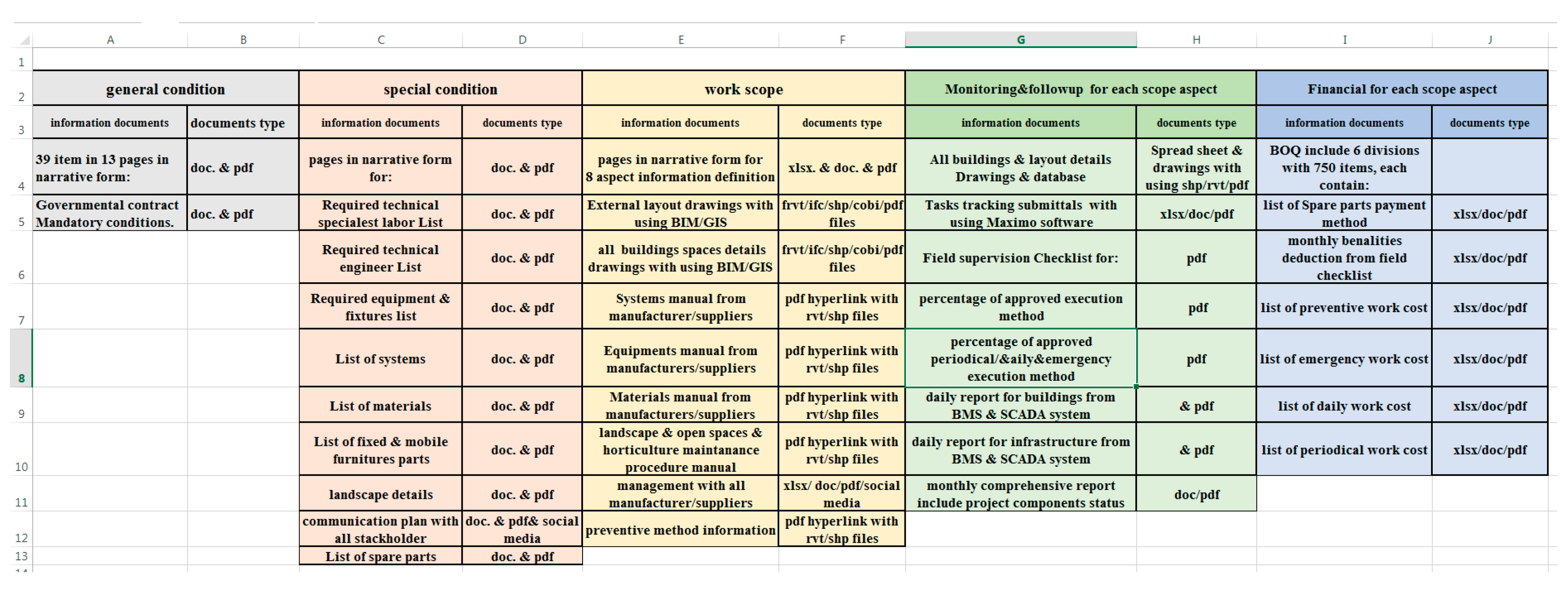
In this stage, all information had been distributed in document using several software e.g.Arcgis, Revit, BMS, Scada and Maximo to explain all the requirements information for the client to execute and monitor each entity for each service registered in AIMM scope; this stage had been arranged into document as follows: general conditions, special conditions, POQ bill of quantities with divisions, drawings with ArcGIS+BIM software with using and execution&moitor information which include: FM execution method information, FM periodical method information, FM preventive method information and FM daily method information Maximo software protocol contain:POQ+DWG's and monitoring BMS. The comprehensive information for all these documents contains mainly: manufacturer catalogs, supplier’s recommendations guidance (cleaning methods - Replacing plan – operation process – malfunctions & damage procedures), technical information, Guarantee’s follow-up, BIM/GIS database, international standard information, as-built document, Maximo software protocol, BMS monitor devices, under call register. Table 8 illustrate AIMM information type as a bidding contract structure for KFU facility management and operation for its assets.

Table 6.
the main five processes to build AIMM model.
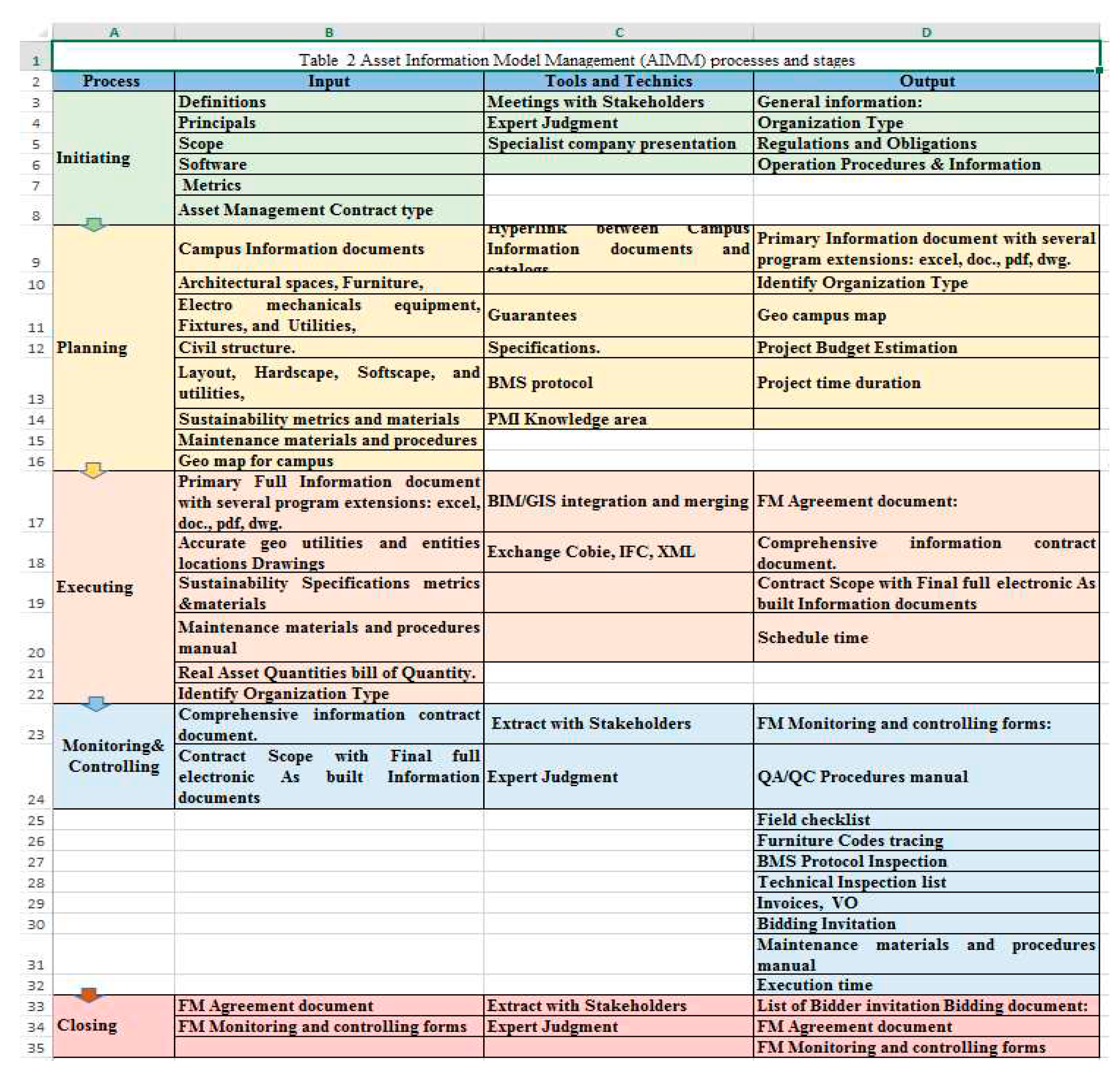 |
Table 7.
AIMM adapted matrix for scope, division and document.
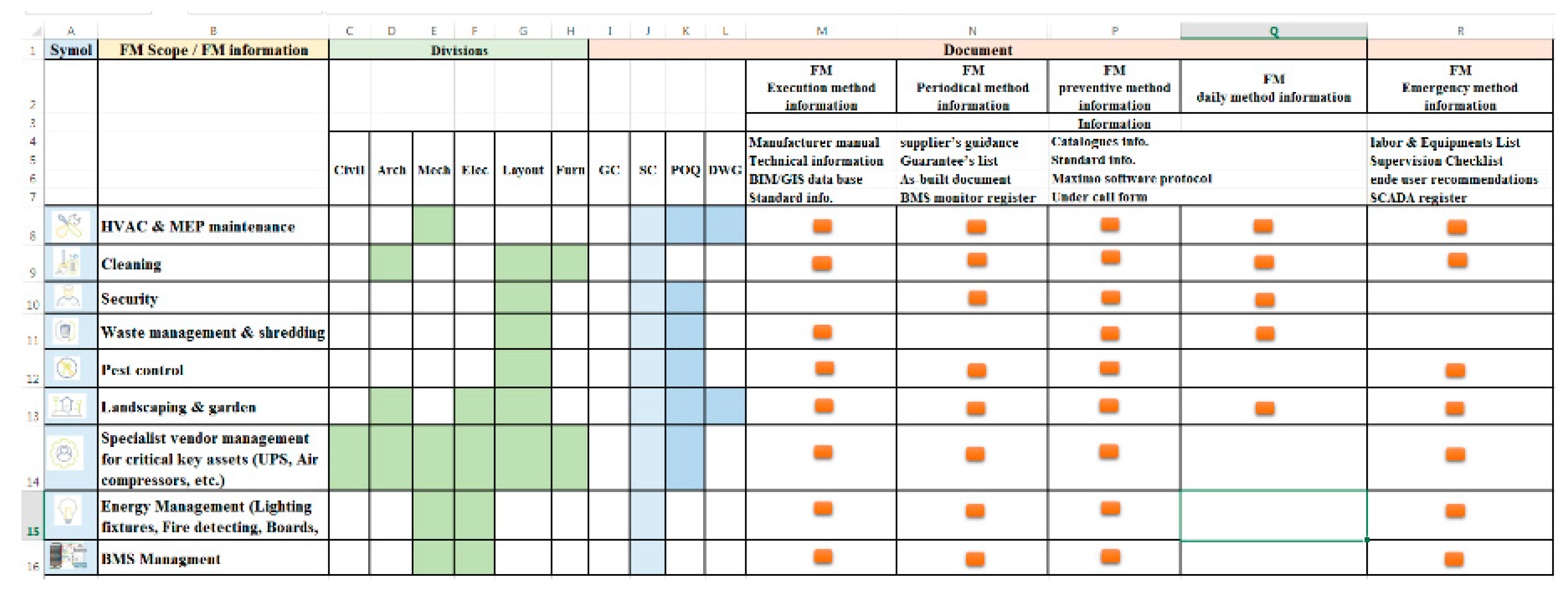 |
Table 8.
AIMM information type as bidding contract structure for KFU facility.
 |
4. Discussion
The study asset information model management structure considers enhancing approach for the organization's asset management construction projects focus on the quality of the contact information for the facility management, which continually affects the performance and monitoring procedures quality within the project operation lifecycle.
The study built applicable, robust, comprehensive, and practical facility management contract based on all available information from international firms’ scope working in facility management market, therefore the study cover seven important aspects and explain its scope and main standards to apply its recommended technical procedures. The study design its structure with significant main sex divisions to identify precisely each entity with its division to facilitate the financial inventory and technical maintenance procedures. The study recommend GIS/BIM integration by using ArcGIS software and Revit software in identifying the spatial allocation attached with its complete information in drawings and specifications format. The study explain the procedure to adjust all information inside the content of the five main facility management contract documents to facilitate and enhance the case study organization to build its own facility management contract document to cover all facilities entities and make robust and precisely technically and financially bidding documents to control and enhance its assets management .
Applying the study model, which include stages in five steps, scope in eight aspects, divisions for all project disciplines, seven documents, and GIS/BIM integration represent the best practice for flow information in asset management contract framing and editing for the facility management market and facilitate other organizations to adjust and compromise the model to manage its own facility management, as well as, it opens the gate to other studies in enhancing the facility management in construction projects in monitoring procedures and tools development, controlling procedures of procurements for facility management, and technical qualifications identification of contractor and consultant teams working in facility management.
5. Conclusion
This paper presents an framework for asset information management model AIMM to build in deeply details the required information in construction projects as asset management contract in robust and comprehensive model based on integration between specific software for asset/facility management e.g.BIM/GIS/BMS/SCADA, As-built document, official results conclusion from different experts involved in the project e.g.client committee, manufacturers/suppliers manual, end user recommendations and etc., and lesson learned from previous contract form. Asset Information Model Management AIMM illustrates an integrated approach for collecting and integrating information, algorithms and knowledge for decision making in KFU as case study. The proposed framework model has several distinguishing features within its sequences stages: (1) AIMM processes and stages with five processes in 23 items as input information, 13 Item as tools and techniques to analyze the information, 23 items as output information; (2) AIMM scope accordingly the study defined the scope of the eight facilities management operation was thus selected; (3) AIMM divisions which illustrate the technical information structure extracted for these eight scope areas and has been formulated in six engineering discipline; (4) AIMM document which illustrate adapted matrix for scope, division and document, as well as, information type as bidding contract structure for KFU asset management which contain full official obvious information of submittals, procedures and forms for work scope, Monitoring&followup and Financial for each entity inside each scope item. The study with its model in case study support both client to follow the best practice manner management to guarantee obtaining distinguish service over lifecycle for its asset, as well as, support the service provider to deliver all proper technical team, labors, materials, equipment in precisely manner according to the approved schedule time to be commitment to accomplish the AIMM contract.
Author Contributions
Conceptualization, E.M.H.I.; methodology, E.M.H.I.; software, E.M.H.I. validation, E.M.H.I.; formal analysis, E.M.H.I.; investigation, E.M.H.I.; resources, E.M.H.I.; data curation, E.M.H.I.; writing—original draft preparation, E.M.H.I.; writing—review and editing, E.M.H.I.; visualization, E.M.H.I.; supervision E.M.H.I.; project administration, E.M.H.I.; funding acquisition, E.M.H.I.; All authors have read and agreed to the published version of the manuscript.
Funding
This work was supported by the Deanship of Scientific Research, Vice Presidency for Graduate Studies and Scientific Research, King Faisal University, Saudi Arabia [Project No. GRANT4,106]
Institutional Review Board Statement
Not applicable.
Informed Consent Statement
Not applicable.
Data Availability Statement
Data available upon request from the first author.
Conflicts of Interest
The authors declare no conflict of interest.
References
- Potkany, Marek; Vetrakova, Milota; Babiakova, Martina. Facility management and its importance in the analysis of building life cycle. Procedia Economics and Finance 2015, 26, 202–208. [Google Scholar] [CrossRef]
- Booty, Frank. Facilities management handbook. Routledge, 2009.
- Tucker, Matthew; Masuri, Mohd Rayme Anang. The rationale to integrate facilities management into the development process. Property management, 2016.
- Jernigan, Dann A. International Facility Management Association (IFMA) 2012 conference. Sandia National Lab.(SNL-NM), Albuquerque, NM (United States), 2012.
- Litvin, Eugeniu. Theoretical reflections on the essence and role of facility management. In: Simpozion Ştiinţific Internaţional al Tinerilor Cercetători. 2018. p. 115-120.
- Ashworth, Simon; Tucker, Matthew; Druhmann, Carsten K. Critical success factors for facility managementemployer's information requirements (EIR) for BIM. Facilities, 2018.
- Evans, P. L. , et al. Facilities management of nhs wales–standardisation and other implictions. Welcome to delegates IRC 2017, 2017, 277. [Google Scholar]
- Chen, Zhen. The principles of facilities management and case studies. In: ARCOM and BEAM Centre Early Career Researcher and Doctoral Workshop on Building Asset Management. 2017. p. 8-19.
- Ozturk, Gozde Basak. Interoperability in building information modeling for AECO/FM industry. Automation in Construction, 2020, 113, 103122. [Google Scholar] [CrossRef]
- Olapade, Daramola Thompson; Ekemode, Benjamin Gbolahan. Awareness and utilisation of building information modelling (BIM) for facility management (FM) in a developing economy: Experience from Lagos, Nigeria. Journal of Facilities Management, 2018.
- Chegu Badrinath, Amarnath, and Shang-Hsien Hsieh. "Empirical approach to identify operational critical success factors for BIM projects." Journal of Construction Engineering and Management 2019, 145, 04018140.
- Matarneh, Sandra T., et al. BIM for FM: Developing information requirements to support facilities management systems. Facilities, 2019.
- Roper, Kathy; Payant, Richard. The facility management handbook. Amacom, 2014.
- Zadeh, Puyan A. , et al. Information quality assessment for facility management. Advanced Engineering Informatics, 2017, 33, 181–205. [Google Scholar] [CrossRef]
- Kummert, Kai; MAY, Michael; Pelzeter, Andrea. Nachhaltiges Facility Management. Berlin: Springer Vieweg, 2013.
- LU, Qiuchen, et al. Moving from building information models to digital twins for operation and maintenance. Proceedings of the Institution of Civil Engineers-Smart Infrastructure and Construction 2020, 174, 46–56. [Google Scholar]
- Heaton, James; Parlikad, Ajith Kumar; Schooling, Jennifer. A Building Information Modelling approach to the alignment of organisational objectives to Asset Information Requirements. Automation in Construction, 2019, 104, 14–26. [Google Scholar] [CrossRef]
- Cartlidge, Duncan. Joined-up cost management. In: New Aspects of Quantity Surveying Practice. Routledge, 2017. p. 50-70.
- Gavrikova, Elizaveta; Volkova, Irina; Burda, Yegor. Strategic aspects of asset management: An overview of current research. Sustainability 2020, 12, 5955. [Google Scholar] [CrossRef]
- Halmetoja, Esa. The conditions data model supporting building information models in facility management. Facilities, 2019.
- Sapp, Don; Scientific, Plexus. Facilities operations & maintenance. Whole Building Design Guide, National Institute of Building Sciences, Washington, DC., USA, 2009.
- Petchrompo, Sanyapong; Parlikad, Ajith Kumar. A review of asset management literature on multi-asset systems. Reliability Engineering & System Safety, 2019, 181, 181–201. [Google Scholar]
- Wuni, Ibrahim Y.; Agyeman-Yeboah, S.; Boafo, Henry K. Poor Facility Management in the Public Schools of Ghana; Recent Empirical Discoveries. Journal of Sustainable Development Studies, 2017, 11.1.
- Leguna, Peris Gerald, et al. Facilities Management of Sports Infrastructure in Tanzania: A Case Study of the Stadia in Dar Es Salaam. In: the 20th annual afres conference. 2021. p. 19.
- Yongkui Li.; Lingyan Cao; Yilong Han; and Jianjun Wei. Development of a conceptual benchmarking framework for healthcare facilities management: Case study of Shanghai municipal hospitals. Journal of Construction Engineering and Management, 2020, 146, 05019016.
- Amos, Daniel; Musa, Zairul Nisham; AU-YONG, Cheong Peng. A review of facilities management performance measurement. Property Management 2019, 37, 490–511.
- Marzouk, Mohamed; Zaher, Mohamed. Artificial intelligence exploitation in facility management using deep learning. Construction Innovation 2020, 20, 609–624. [Google Scholar]
- Redlein, Alexander; Stopajnik, Eva. Facility Services: An Underestimated Sector?. In: Eurasian Business and Economics Perspectives. Springer, Cham, 2021. p. 197-204.
- Araszkiewicz, Krystyna. "Digital technologies in Facility Management–the state of practice and research challenges." Procedia Engineering 196 (2017): 1034-1042.
- Aziz, Nor Diana; Nawawi, Abdul Hadi; Ariff, Nor Rima Muhamad. Building information modelling (BIM) in facilities management: opportunities to be considered by facility managers. Procedia-Social and Behavioral Sciences 2016, 234, 353–362. [Google Scholar] [CrossRef]
- Pärn, Erika A. ; Edwards, David J.; Sing, Michael CP. The building information modelling trajectory in facilities management: A review. Automation in construction 2017, 75, 45–55. [Google Scholar] [CrossRef]
- Shash, Ali Ali; Habash, Salah Ibrahim. Construction Contract Conversion: An Approach to Resolve Disputes. Journal of Engineering, Project & Production Management 2020, 10. [Google Scholar]
- Alharby, Maher; Van Moorsel, Aad. Blockchain-based smart contracts: A systematic mapping study. arXiv preprint arXiv:1710.06372, 2017. [36] Saudi Aramco organization, facility management contract, 2019.
- Raslan, Azza A. Public Policy Considerations in Competition Enforcement: Merger Control in South Africa. 2016.
- Abdeen, F. N.; Sandanayake, Y. G. Facilities management supply chain: functions, flows and relationships. Procedia Manufacturing, 2018, 17, 1104–1111. [Google Scholar] [CrossRef]
- Drion, Bernard; MELISSEN, Frans; WOOD, Roy. Facilities management: lost, or regained?. Facilities, 2012.
- Turpen, Paula B., et al. Metrics for success: Strategies for enabling core facility performance and assessing outcomes. Journal of Biomolecular Techniques: JBT 2016, 27, 25.
- Kang, T.; Park, S.; Hong, C. BIM/GIS-based data integration framework for facility management. In: Geoprocessing 2016: Eighth International Conference on Advanced Geographic Information Systems, Applications, and Services. 2016. p. 100-105.
- Bahri, MA Saiful, et al. Development of GIS Database and Facility Management System: Asset and Space in UKM. The International Archives of Photogrammetry, Remote Sensing and Spatial Information Sciences, 2019, 42, 563–571.
- Wong, Johnny Kwok Wai; GE, Janet; HE, Sean Xiangjian. Digitisation in facilities management: A literature review and future research directions. Automation in Construction 2018, 92, 312–326. [Google Scholar] [CrossRef]
- 41. Mirarchi, Claudio, et al. Supporting facility management processes throughend-users' integration and coordinated BIM-GIS technologies. ISPRS International Journal of Geo-Information, 2018, 7, 191. [CrossRef]
- Sani, Mohammed Jawaluddeen; Rahman, A. Abdul. GIS and BIM integration at data level: A review. The International Archives of Photogrammetry, Remote Sensing and Spatial Information Sciences 2018, 42, 299–306.
- Volk, Rebekka; Stengel, Julian; Schultmann, Frank. Building Information Modeling (BIM) for existing buildings—Literature review and future needs. Automation in construction 2014, 38, 109–127. [Google Scholar] [CrossRef]
- Nicał, Aleksander K. ; Wodyński, Wojciech. Enhancing facility management through BIM 6D. Procedia engineering 2016, 164, 299–306. [Google Scholar] [CrossRef]
- Sharafat, Abubakar, et al. BIM-GIS-based integrated framework for underground utility management system for earthwork operations. Applied Sciences 2021, 11, 5721. [Google Scholar] [CrossRef]
- D'amico, Fabrizio, et al. BIM and GIS data integration: a novel approach of technical/environmental decision-making process in transport infrastructure design. Transportation Research Procedia 2020, 45, 803–810. [Google Scholar] [CrossRef]
- Chen, W. , Chen, K., Cheng, J. C., Wang, Q., & Gan, V. J. BIM-based framework for automatic scheduling of facility maintenance work orders. Automation in Construction 2018, 91, 15–30. [Google Scholar]
- Xu, Jinying, et al. From smart construction objects to cognitive facility Management. In: Cyber-Physical Systems in the Built Environment. Springer, Cham, 2020. p. 273-296.
- Cavka, Hasan Burak; Staub-French, Sheryl; Poirier, Erik A. Developing owner information requirements for BIM-enabled project delivery and asset management. Automation in construction 2017, 83, 169–183. [Google Scholar] [CrossRef]
- Tang, Shu, et al. BIM assisted Building Automation System information exchange using BACnet and IFC. Automation in Construction 2020, 110, 103049. [Google Scholar] [CrossRef]
- Malhotra, Avichal; Frisch, Jérôme; Van Treeck, Christoph. Technical Report: Literature Review Concerning IFC, gbXML and CityGML Data Models for Energy Performance Simulation. Aachen, Germany: Universitätsbibliothek der RWTH Aachen, 2019.
- Kerzner, Harold. Using the project management maturity model: strategic planning for project management. John Wiley & Sons, 2019.
- Flamini, Alessandro, et al. BIM and SCADA integration: the Dynamic Digital Twin. In: 2022 IEEE/IAS 58th Industrial and Commercial Power Systems Technical Conference (I&CPS). IEEE, 2022. p. 1-7.
- Saback De Freitas Bello, Vanessa, et al. Framework for Bridge Management Systems (BMS) using Digital Twins. In: International Conference of the European Association on Quality Control of Bridges and Structures. Springer, Cham, 2021. p. 687-694.
- Durdyev, S. , Ashour, M., Connelly, S., & Mahdiyar, A. Barriers to the implementation of Building Information Modelling (BIM) for facility management. Journal of Building Engineering 2022, 46, 103736. [Google Scholar]
- King Faisal University, facility management contract, 2020. https://www.kfu.edu.sa/ar/Departments/Campus/Pages/QC.aspx, (site visited in June 2023).
- King Faisal University, monthly report and invoices, operation and maintenance department, 2020, https://www.kfu.edu.sa/ar/Departments/SeniorManagement/vice-president/Pages/Home-new.aspx, (site visited in June 2023).
Figure 1.
Cross-functional competencies areas in the facility management.
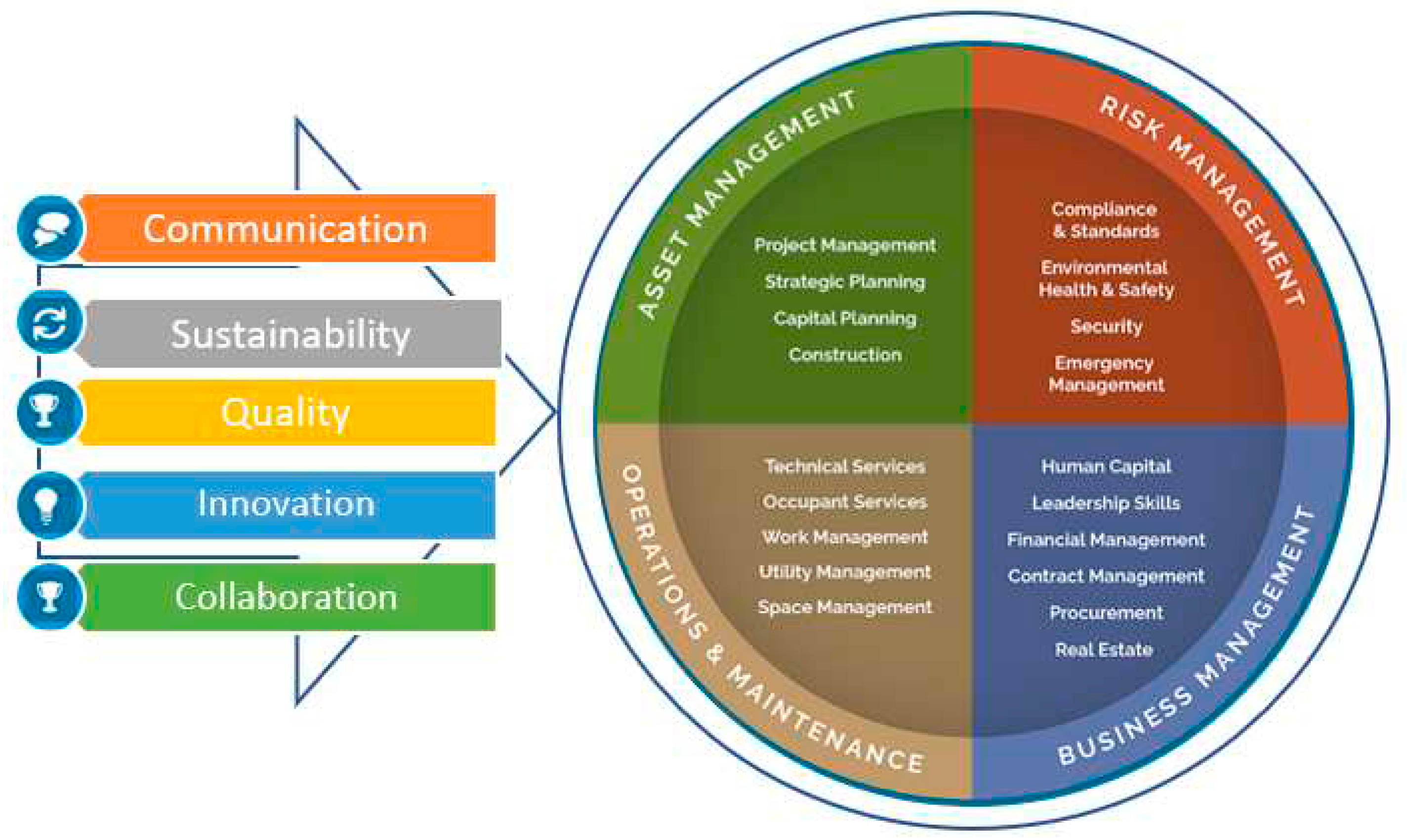
Figure 2.
Integrating BIM, GIS, data exchange to make facility management workflows information.
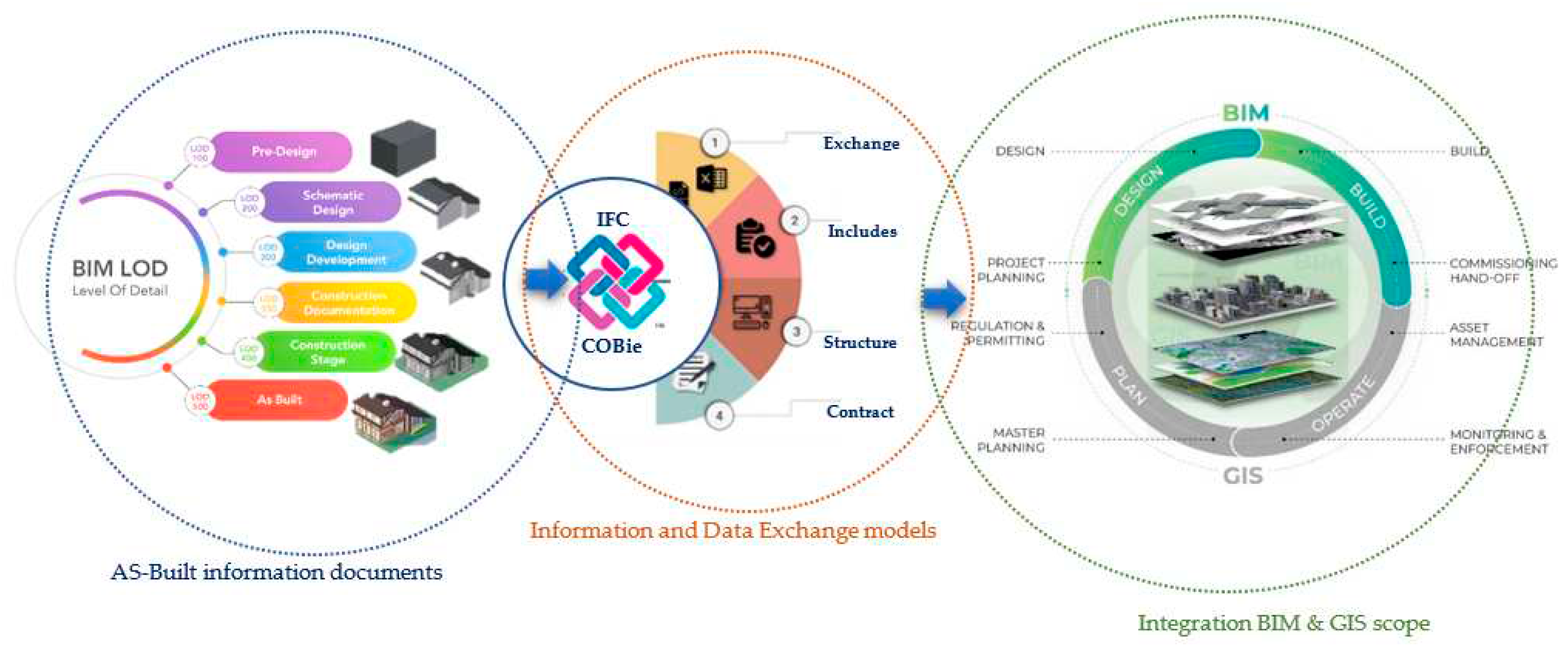
Figure 3.
BMS scope for asset management in construction projects.
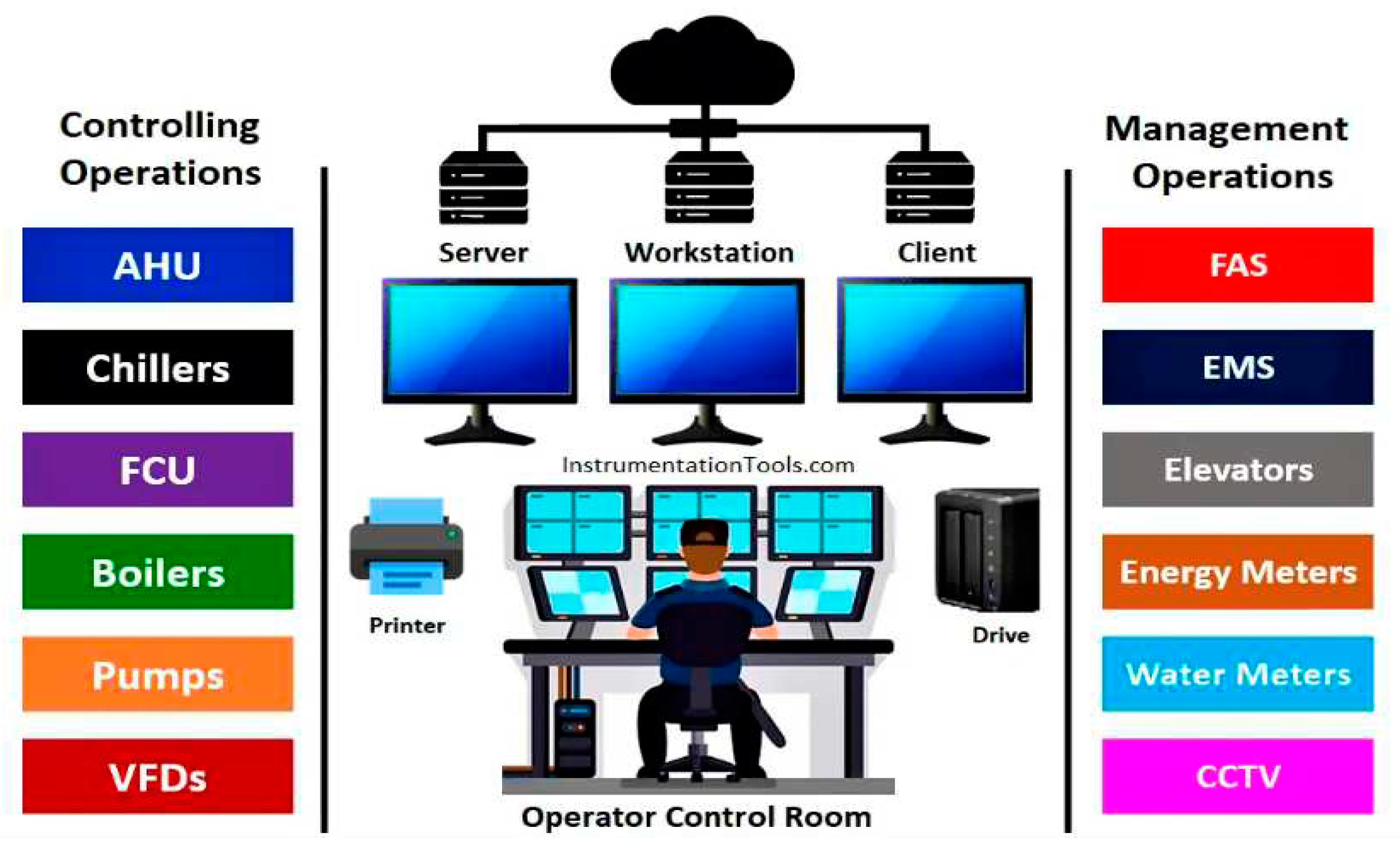
Figure 4.
Scope diagram of SCADA system for asset management in construction projects.
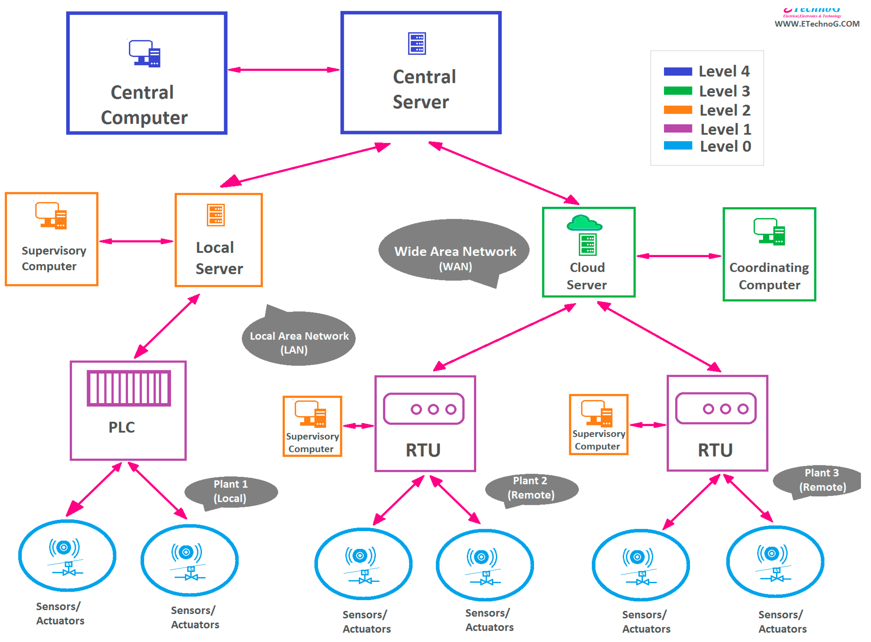
Figure 5.
In-house FM department.
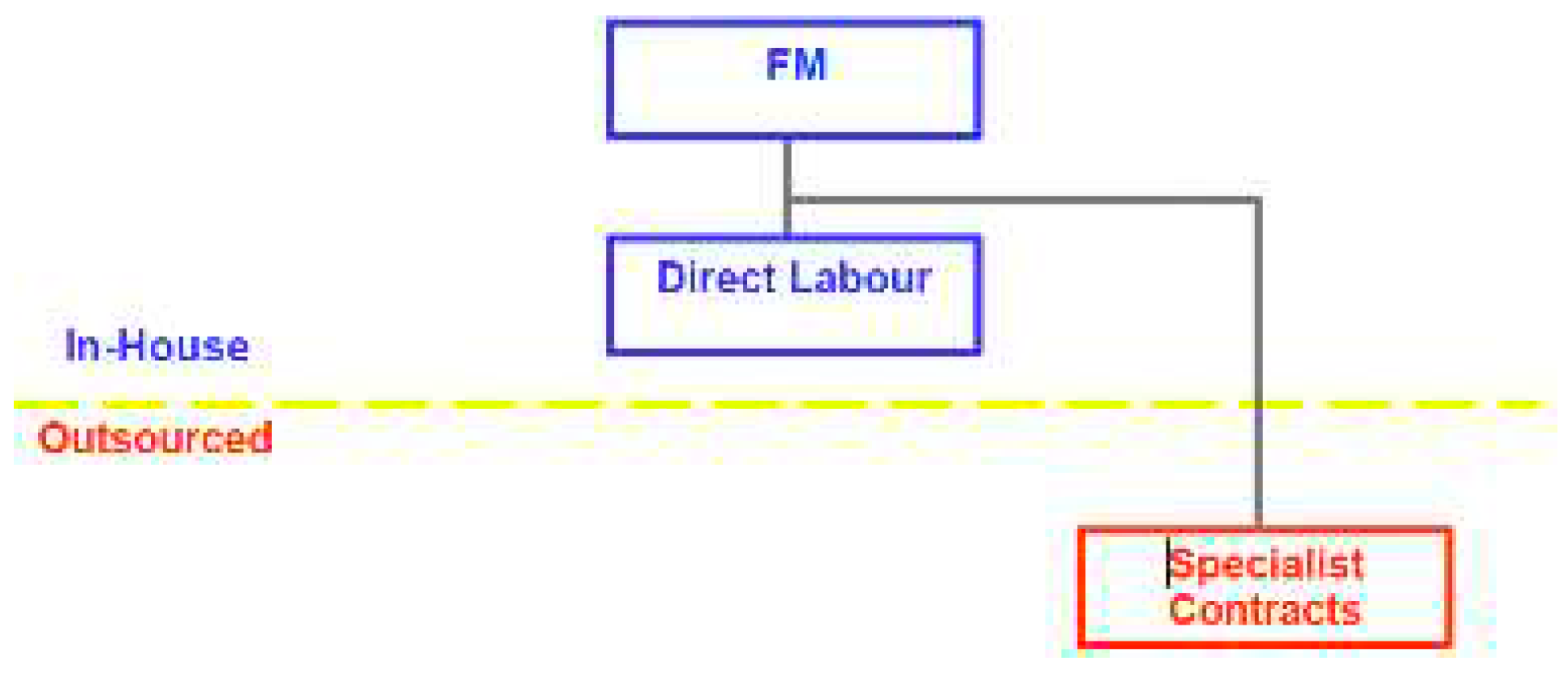
Figure 6.
Out-tasked service contracts.
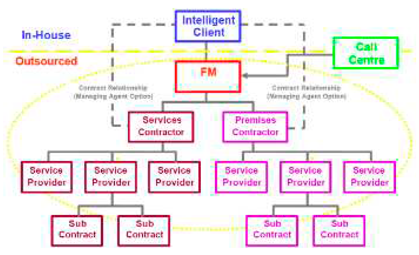
Figure 7.
Outsourced managing agent FM contract.
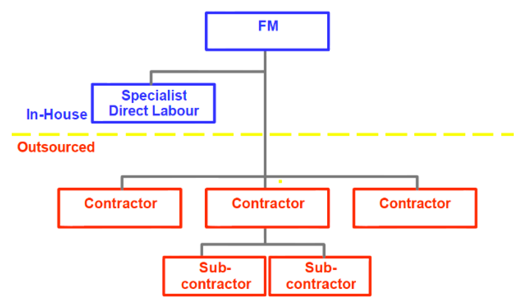
Figure 8.
AIMM model concept.
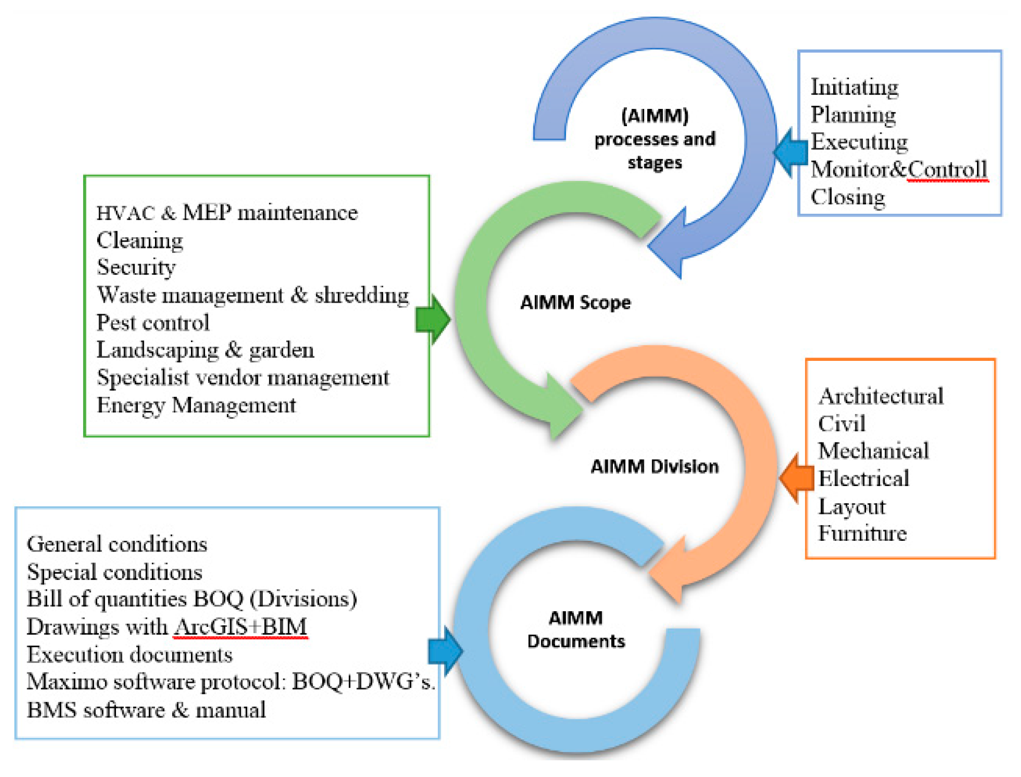
Table 1.
Service Excellence for higher education.
 | ||
|
|
|
|
|
|
|
|
|
|
|
|
|
|
|
|
||
Table 2.
Centralized support services.
|
|
|
 |
Table 3.
Facility management Standard, accreditation, and Certification.
 |
Table 4.
contract information for existing King Faisal University FM.
 |
Disclaimer/Publisher’s Note: The statements, opinions and data contained in all publications are solely those of the individual author(s) and contributor(s) and not of MDPI and/or the editor(s). MDPI and/or the editor(s) disclaim responsibility for any injury to people or property resulting from any ideas, methods, instructions or products referred to in the content. |
© 2023 by the authors. Licensee MDPI, Basel, Switzerland. This article is an open access article distributed under the terms and conditions of the Creative Commons Attribution (CC BY) license (http://creativecommons.org/licenses/by/4.0/).
Copyright: This open access article is published under a Creative Commons CC BY 4.0 license, which permit the free download, distribution, and reuse, provided that the author and preprint are cited in any reuse.


