Submitted:
06 September 2023
Posted:
07 September 2023
You are already at the latest version
Abstract
Remote sensing methods have the potential to improve lake water quality monitoring and deci-sion-making in water management. This reviews introduces novel findings in the field of opti-cally active water quality parameters using remote sensing. It summarizes existing retrieval methods (analytical, semi-analytical, empirical, semi-empirical, and artificial intelli-gence/machine learning (AI/ML)), examines measurement methods used to determine concen-tration of specific water quality parameters, summarizes satellite systems that enable temporal data for understanding the state of the lake with focus on water quality parameters, and pro-poses enhancements for future research of lake water quality using remote sensing. As part of this review, eight optically active biological and physical water quality parameters were ana-lyzed, including chlorophyll-α (chl-α), transparency (Secchi disk depth (SDD)), colored dis-solved organic matters (CDOM), turbidity (TUR), electrical conductivity (EC), surface salinity (SS), total suspended matter (TSM), and water temperature (WT). The research proposes a shift from point-based data representation to a more reliable raster representation and encourages optimizing grid selection for in situ measurements by combining hydrodynamic model with re-mote sensing methods. This review presents a comprehensive summary of the bands, band combinations, and band equations per sensor for eight optically active water quality parameters as listed in Tables A1-A8. The review’s findings indicate that use of remotely sensed data is an effective method for estimating water quality parameters in lakes, with a significant increase in global utilization. The review highlights potential solutions and limitations to the challenges of remote sensing water quality determination in lakes.
Keywords:
water management
; remote sensing
; lake
; water quality
; optically active
; water quality parame-ters
1. Introduction
Lakes and other inland waters are very important for their environment. Lakes are essential ecosystems covering less than one percent of the surface area [1], and are an essential component of water resources (Goal #6) in the Sustainable Development Goals (SDGs) of the United Nations [2]. They provide living space for a large number of species and are vital components of hydrological, nutrient and carbon cycles [3]. Lake water is used as drinkable water, industry, irrigation, energy production, transportation, biodiversity, aesthetics, fishing, and recreation [3,4,5]. The necessity for sustainable water supplies include an ongoing assessment of the quality of existing available water resources.
Globally, eutrophication is a severe problem for inland waters [6]. Anthropogenic exploitation, eutrophication, inorganic and organic pollutants, morphological changes, population growth, and the effects of climate change like acidification or rising water temperatures increased nutrient input and primary output, worsened water quality, decreased biodiversity, and endangered the ecological functioning of inland waters worldwide [1,7,8,9]. Climate changes are increasingly affecting the quality of lake water, the health of the lake ecosystem [10] and ecology [11,12,13]. According to the Global Risks Report 2023 [14], the natural resource crisis, including water shortages due to human overuse and mismanagement, is ranked sixth among the top 10 long-term global risks. These risks are assessed based on their importance over a 10-year period.
Shallow lakes are the most common lake type in the world [15], and they are especially vulnerable to eutrophication, which threatens the ecological, social, cultural, spiritual, and economic aspects that these ecosystems provide [16,17]. In reality, shallow lakes are more sensitive to anthropogenic eutrophication, have a higher risk of water quality issues, and are more receptive to acquiring huge amounts of nutrients due to strong water-sediment interactions, sedimentation, export, and sedimentary exchange [18]. Improving lake management techniques requires greater knowledge of the dynamic interactions between lake depth and social and environmental variables [19]. Locations of in situ measurements should consider hydrodynamic models, especially in shallow lakes due to their unique hydrodynamic behavior. In situ measurements calibrate and validate models for retrieving water quality, while remote sensing is used for comprehensive lake-wide analysis. The choice of bands, band combinations, and equations for retrieving optically active parameters using remote sensing should not solely depend on water depth but on in situ measurements. Because the results of remote sensing methods for evaluating lake water quality often coincide regardless of lake depth, the major emphasis of this review is to give an insight into remote sensing methods for retrieving water quality and water quality metrics for lakes in general. Although, in optically shallow water, a portion of the light emitted includes reflection at the bottom and it should be taken into account in the analysis.
The term “water quality” encompasses the physical, chemical, and biological attributes of water that must be upheld to satisfy diverse water applications such as drinking, irrigation, and recreation [20]. Traditionally, physical, chemical, and biological indicators of water quality include comprehensive field monitoring networks that include in situ measurements, sampling, and laboratory analysis. In situ measurements can acquire numerous water quality parameters with fine accuracy by utilizing specific sampling points. However, they are long-lasting, tiring, and expensive, with large-scale monitoring restrictions [21,22]. The typical in situ sampling method is unable to readily determine spatial or temporal variability in water quality because sampling points are not properly distributed, which can lead to incorrect classifications of water quality [23,24]. Since the 1970s, breakthroughs in space science, the expanded use of advanced computers and their capabilities have made remote sensing methods viable instruments for effective and efficient monitoring and identification of large-scale regions and inland waterbodies with quality issues while offering data continuity for the following decades [25,26,27,28,29,30,31,32,33,34,35,36,37,38,39,40,41,42,43,44]. Increasingly, remote sensing (airborne and/or spaceborne) it is used as a means in the analysis of stagnant water, frequently combined with conventional approaches, to overcome some of the shortcomings of in situ methods [45,46,47,48]. Dekker et al. [49] were among the first to compare water quality assessment methods (in situ monitoring of water quality, mathematical modeling, and remote sensing) to determine the importance of remote sensing as a source of unique spatial information. Remote sensing is cost-effective and time-efficient for researchers operating at the local, regional, and global levels [47,50], allowing for the survey of sensitive or hazardous sites while the operator remains at one safe point [51,52]. Furthermore, modern remote sensing methods and databases are a priceless source for obtaining data from the previous years on lake ecological indicators, especially in unstudied lakes where information and in situ monitoring are limited and there are significant data gaps. Data from remote sensing can deliver immediate information on quick changes in a lake, such as algae blooms, strong rainfall, or droughts. With adequate in situ validation, remotely sensed airborne and/or satellite imagery is essential for the full assessment and management of waterbodies [25] and may be further enhanced via interdisciplinary cooperation to enable high-accuracy interpolation, requiring less time, work, and financial inputs [53,54,55,56].
The traditional method for monitoring water quality encompasses three categories of water indicators: (1) physical parameters such as water temperature (WT), transparency (Secchi disk depth (SDD)), surface salinity (SS), turbidity (TUR), total suspended matter (TSM), Colored Dissolved Organic Matters (CDOM), odor, and electrical conductivity (EC); (2) chemical parameters such as pH, dissolved oxygen (DO), chemical oxygen demand (COD), biochemical oxygen demand (BOD), total organic carbon (TOC), dissolved organic carbon (DOC), total nitrogen (TN), ammonia nitrogen (NH3-N), nitrate nitrogen (NO3-N), total phosphorus (TP), orthophosphate (PO4), heavy metal ions, and nonmetallic toxins; and (3) biological parameters such as chlorophyll-α (chl-α), total bacteria and total coliforms. The analyzed water quality parameters are divided into two categories using remote sensing techniques. The initial classification comprises of indicators that possess active optical characteristics such as chl-α, TSM, and CDOM. These indicators impact the radioactive transfer process of waves through varying absorption of the spectrum. The second classification comprises of indicators that lack explicit optical properties, such as TN, TP, and DO. Indicators of this nature are frequently evaluated through statistical correlations with other indicators [56]. In this review, the focus of research is on eight optically active water parameters (Table 2), as follows: chl-α [30,32,33,35,57,58,59,60,61,62,63,64,65,66,67,68,69,70,71,72,73,74,75,76,77,78,79,80,81,82,83,84,85,86,87,88,89,90,91,92,93,94,95,96,97,98,99,100,101,102,103,104,105,106,107,108,109,110,111], transparency (SDD) [33,35,57,58,59,67,77,87,88,90,93,95,97,101,102,103,110,112,113,114,115,116,117,118,119,120,121,122,123,124,125,126], CDOM [60,75,77,82,83,90,92,102,115,127,128,129,130,131,132,133,134,135,136,137,138,139,140,141,142,143,144,145,146,147], EC [148,149,150,151,152,153,154], TUR [32,33,35,58,60,67,75,98,102,104,109,110,150,152,153,155,156], SS [150,157,158,159,160,161,162,163,164,165,166,167,168,169,170,171,172,173,174,175,176,177,178,179,180,181], TSM [30,58,59,67,75,82,90,92,97,99,100,101,113,119,182,183,184,185,186,187,188,189,190,191,192], and WT [87,103,150,193,194,195,196,197,198,199,200,201,202,203,204,205,206,207,208,209,210,211,212,213].
1.1. Objectives
In order to facilitate further comprehension and implementation of remote sensing methods, including sensors mounted on spaceborne and airborne Earth observation (EO) platforms, in water quality monitoring and evaluation for lakes, a systematic literature analysis was conducted to summarize the current research status and general trend.
This review presents a summary of numerous research studies assessing water quality using remotely sensed data. It emphasizes the potential usefulness of these findings for environmental researchers and encourages further research and innovation in the field. The review aims to gain a centralized resource for researchers to gain insights into current practices and draw conclusions on potential areas for improvement or additional contributions. It examines optically active parameters retrievable through satellite imagery and focuses on lakes, gathering in situ and satellite data from experts in ecology, biology, chemistry, and hydrology. Satellite images serve as the sole source of information in the absence of available data, and Landsat 5 and other older satellite systems provide temporal, historical data.
The manuscript contributes new knowledge in the field by aiming to improve data representation reliability by moving from point to raster representation. The review takes into account a considerable number of articles published since 2015 and highlights the practicality of methods for selecting and computing relevant parameters for monitoring lakes.
The objectives of this paper are to (1) provide bibliometric analysis, (2) to provide insight into the current state of using remote sensing methods to monitor water quality for lakes, (3) summarize retrieval methods used in literature, and (4) highlight specific optically active water quality parameters in depth depending on the methods used to measure their concentrations.
Finally, potential solutions and limitations to the current challenges of remote sensing water quality determination in lakes are presented in this paper.
2. Bibliometric Analysis
Long ago, remote sensing was acknowledged as a method for global tracking of inland water quality. Airborne and satellite spectral data collection have been used since the early 1970s to analyze a broad collection of water quality parameters [213,214] (Figure 1). Previous reviews [55,56,215,216,217,218,219] have offered excellent summaries of hundreds of publications presenting models for evaluating the biological, chemical, and physical properties of complex waterbodies published by scientists during the past 50 years. General trends in this sense were revealed after extensive bibliometric research of the Elsevier Scopus database (conducted in April 2023). Database titles, keywords, and abstracts from 1971 until 2022 for the terms ‘remote sensing’, ‘water quality’, and ‘lake’ in the English language were searched. The search found 27,950 unique publications published for terms ‘water quality’ and ‘lake’ and 1,593 unique publications published for terms ‘remote sensing’, ‘water quality’, and ‘lake’. Globally, the number of publications employing remote sensing for lake water quality falls significantly behind those that do not, as shown in Figure 1.
Since the 1970s, papers describing the monitoring and assessment of water quality for lakes utilizing remote sensing methods have arisen (Figure 1). Publication numbers for the specific dataset follow a power law distribution, with a similar increase after 2008. The greatest increase in remote sensing studies from one year to the next happens after 2008, coinciding with the availability of free Landsat imagery. This conclusion is consistent with prior research indicating that the publication of the Landsat archive led to an increase in the frequency and scope of EO studies in different domains [220] and has resulted in a more comprehensive understanding of inland waterbodies to concentrate on demanding scientific problems and expanding research scales. In the publications based on remote sensing analyzed for this research on lakes, in the past decade, twice as many studies have been published (2013–2022), as in the previous 42 years combined (1971–2012). The majority of the publications was published from United States of America and China. More than half of the publications from the bibliometric analysis are from those two countries. The origin of rest of the publications is from countries across Europe and India, Canada, Japan, and Australia, as seen in Figure 2.
The literature review suggests that the recent advancement in evaluating inland water quality through remote sensing initiatives can be attributed to the challenges associated with remote sensing of complex waterbodies and the limited availability of suitable sensors for this purpose (namely hyperspectral airborne or space-borne remote sensing which capture extensive spatial and spectral information, especially in small lakes) [221]. The complex bio-optical property of a static waterbody (vegetation, pollutants) creates problems in establishing an internal correlation between spectral responses and optically inactive water quality parameters. In tandem with the increase in remote sensing data accessibility during the past decade, in situ data accessible for model calibration and validation has increased. Modern databases offered by government agencies, nongovernmental organizations, and scholars provide a variety of freely accessible in situ data. In Europe, these include Eye on Water (www.eyeonwater.org) and Seen-monitoring (www.seen-transparent.de) [218]. These established databases can be enhanced with innovative datasets collected through citizen science activities. In this way, data continuity is offered, cost and time savings for researchers, as well as a multitude of samples for calibration and validation of derived models.
Figure 3 shows the results of the bibliometric analysis, which identifies the waterbodies that have been most frequently studied in relation to the estimation of lake water quality using remote sensing techniques. Reservoirs are often studied alongside lakes due to their comparable water quality complexity. Inland waterbodies typically include lakes and rivers. Despite their distinct characteristics (lakes being stationery and rivers being moving waterbodies), researchers often study and review both types of waterbodies simultaneously. Coastal areas often contain lakes that are influenced by the nearby marine environment, such as estuaries, seas, lagoons, or oceans. The marine influence on lakes is crucial for saline and brackish lakes, as inland waters experience notable variations in salinity. These variations are primarily caused by seasonal changes in river runoff and interactions with the ocean through tides and flushing times.
1.3. An overview of methods for retrieving water quality and water quality parameters based on remote sensing
3.1. Methods for Retrieving Water Quality
The basic principle of inversion of water quality using remote sensing methods consists in the following. First, using in situ water quality monitoring data and equivalent remote sensing imagery, a model is established. After that, the distribution of water quality over a longer period over a larger area is monitored based on the model (i.e., inverse modeling) [56]. Bio-optical methods use the correlation between a waterbody's optical properties and its optically active parameters to assess water quality [222]. Optically active parameters, such as TSM, CDOM, and chl-α, interact with light and modify radiation in the water column by absorption and scattering processes unique to each parameter [26] and can be obtained through direct retrieval [106,192,223]. Additional parameters include acidity, chemicals, pathogens, TN, TP, COD, and DO which lack optical activity, don't alter the spectral features of reflected light and have no clearly distinguishable signals, but can be interpreted and inferred from those measurable water quality parameters with which there have substantial relationships [26,224]. Bio-optical models can also describe and predict the water’s “bio-optical state”, or its optical properties as a function of biological activity [225].
Five methods—empirical [49,55,56,108,214,215,226,227,228,229,230,231,232,233], semi-empirical [49,67,76,127,218,227,234,235,236,237,238,239,240,241,242,243,244,245,246,247,248,249,250], semi-analytical [39,56,191,215,218,219,225,251,252,253,254,255,256,257,258,259,260,261,262,263,264,265,266], analytical [39,56,232,234,262,263,264,265,266,267,268], and artificial intelligence/machine learning (AI/ML) [73,218,227,269,270,271,272,273,274,275,276,277,278,279,280,281,282,283,284,285,286,287,288,289,290,291,292,293,294,295]—can be used to monitor and assess water quality using remote sensing imagery. The analytical method is also called physical. AI/ML methods are characterized by computational complexity and nonlinear relationship management, even though they are empirical. Analytical and semi-analytical methods require theoretical analyses of spectral data, while empirical and semi-empirical methods use statistical analyses and are widely used due to their complexity. The empirical and analytical methods differ in how they develop models based on water quality concentration and reflectance. Linear and non-linear regression methods may fail to model complex nonlinear relationships. Unlike statistical or physical models, AI/ML method can capture linear and nonlinear relationships. Methodically examining the inherent optical characteristics of water quality parameters can reduce or eliminate the effect of irrelevant parameters and anthropogenic actions on the quantified parameter.
Usually, water quality models, based on remote sensing imagery, are created for specific waterbodies by examining the correlation between spectral responses and in situ measured water quality parameters, serving as indicators of water pollution, sky background, and weather conditions. The performance of water quality retrieval models is dependent on spatial factors, which may render them effective in certain regions but unsuitable for others. This is particularly true for bio-optical models, where the inherent optical properties of a region are crucial in determining their applicability [215]. Satellite-based water quality models have temporal limitations due to their reliance on short-term in situ data for their design. The water quality parameters in a given water area exhibit seasonal variation owing to meteorological factors [296].
3.1.1. Analytical Methods
Analytical methods use inherent and apparent optical properties to model reflectance and vice versa. Underwater light fields, remotely detected radiance, and water quality parameters are physically related [49]. Analytical models link water quality parameters with water-leaving radiance using radiation transmission theory [267]. The analytical method’s physical mechanism can simultaneously identify all water parameters using well-established parameter properties and large in situ data [55] and portability is good, but it requires a highly accurate measuring instrument, high application costs, and challenges to widespread adoption [234]. Most satellite sensors' spectral resolutions differ from those measured close to the ground, making model development harder. Analytical model-based quantitative remote sensing inversion is difficult and rarely used for all water quality parameters [232,268].
3.1.2. Semi-Analytical Methods
Analytical and semi-analytical models use the physics-based optical properties of water and the atmosphere [251,252]. Semi-analytical methods simplify analytical models. Semi-analytical model parameters require statistical analysis [253,254]. Most semi-analytical models are three-band models [255]. The three-band model identifies the optimal three-band combinations related to the absorption coefficient and quantifies the correlation between the coefficient and water quality parameters. Theoretical absorption and backscattering values are calculated by modeling the inherent optical properties of a waterbody with apparent optical properties including illumination conditions, sensor orientation, and field of view [225,251,256,257]. Some scientists created semi-analytical models based on water column radiative transfer (e.g., [258,259,260]). The radiative transfer equation separates optically active parameters from water-leaving radiation. Inversion and look-up tables are the main radiative transfer equation solutions. The radiance spectra that have left a waterbody are cataloged in the look-up tables, which are a huge library of such spectra with known parameter concentrations, inherent optical properties, bathymetry, and bottom characteristics. The closest match for each variable is calculated using the spectral signatures of the images and the database entries. Inversion methods use radiative transfer and constant and variable model parameters to replicate lake spectral signatures. Variable parameters are repeatedly adjusted for each pixel until the simulated and real-world spectral signatures match [219]. An inverse equation can predict optically active parameters from these values. Semi-analytical models that use in situ observations to parameterize the inverse equation are the most common physics-based algorithms for remote sensing inland water quality [215]. This inverse modeling method provides simultaneous estimates for several water quality parameters. However, model development is difficult and requires knowledge of atmospheric composition, bottom reflectance, and substantial in situ sampling, depending on atmospheric corrections [218]. Semi-analytical models have been successfully applied on broad spatiotemporal scales. Semi-analytical modeling is better explained in Dekker, Vos, and Peters [191,261], Giardino et al. [256], Morel [225], and IOCCG [251]. Semi-analytical and analytical methods are used to retrieve mainly optically active parameters, such as chl-α, TSM, CDOM, and SDD [39,56,262,263,264,265,266].
3.1.3. Empirical Methods
The empirical method computes statistical correlations between in situ water quality parameter values and spectral response values to derive distinctive channels or channel combinations [55,56,226]. Regression models establish a relationship between water quality parameters and characteristic channels or combinations of channels, which is used to derive the inversion algorithm [108]. Empirical methods include linear regression, single-channel, channel-combination, principal component analysis, and others. The empirical method uses regression analysis to quickly create a water quality inversion model without complex physical parameters. Regression methods show the relationship between remotely observed radiance and water quality parameters, but they lack physical mechanisms and multitemporal validity, resulting in uncertainty and limited applicability across spatial and temporal domains. Most empirical models use multivariate regression because inland waterways are optically complex [227]. Since the downwelling irradiance field and water surface conditions may change between remote sensing missions, empirical model estimates will always require in situ data [49]. During empirical modeling, at the local level, the optical properties of water specific to that location are taken into account, however, optically inhomogeneous waterbodies and variable atmospheric conditions make parameterization difficult [228,229]. Model transparency, simplicity, and low computational needs often outweigh these drawbacks. These methods are more accurate than spectral and bio-optical models because they take into account the waterbody's specific properties [215]. The empirical method is easier to implement because it is not necessary beforehand knowledge of the frequently complex interactions between water and light [227]. The empirical method is most commonly used to assess TUR, chl-α, and trophic status [214,230,231]. These methods may not work for complex compositions of water quality parameters, such as phytoplankton pigments, TSM, and CDOM, because they do not have unique absorption features and greatly increase the uncertainty in inversion [232,233].
3.1.4. Semi-Empirical Methods
Semi-empirical methods combine empirical and analytical methods [234]. Semi-empirical models identify wavebands to correlate water quality parameters with remote sensing data, it combines statistical analysis with water spectral theory [235]. They require statistical and measured spectral analysis [236]. Selecting characteristic bands and models requires spectral analysis of water quality parameters. The statistical analysis integrates this knowledge by focusing on carefully selected spectral regions and using relevant wavebands as correlates. Semi-empirical methods use physical and spectral data, such as absorption features, to create algorithms that correlate with measured parameters. Statistical coefficients usually have a calibration time and place. The semi-empirical method integrates waterbody reflectivity with measured parameter concentration, giving it physical significance and ease of implementation [234]. Validity is only assumed within the algorithms' often-limited range of optical water quality data [49]. Semi-empirical models do not model the inherent optical properties of a waterbody like semi-analytical models. Instead, they improve the parameter’s spectral properties and reduce optical parameter noise. Physically based semi-empirical models are more generalizable than completely empirical ones. Since they measure absorption characteristics and scattering peaks at certain wavelengths, they can only be used with sensors with properly positioned band centers and enough spectral resolution [218]. Spectral band ratios and shape algorithms are popular because they are generalizable and easy to use in many locations. Since they assume consistent water and atmospheric conditions, inland applications are easy to implement but lack precision. This may cause large estimation errors across a time series. Spectral band ratios and spectral shape methods are better for assessing regional water quality parameter distributions than precise estimates [227]. The semi-empirical method's large amount of in situ measured data limits its temporal and spatial applicability. Chl-α, TSM, CDOM, SDD, and TUR are often assessed semi-empirically [67,76,127,237,238,239,240,241,242,243,244,245,246,247,248,249,250].
3.1.5. Artificial Intelligence/Machine Learning (AI/ML) Methods
Along with artificial intelligence (AI), remote sensing has increasingly used machine learning (ML) techniques. AI/ML are empirically based and outperform band ratios, spectral shape, and bio-optical inversion methods. Empirical data underlies machine learning, thus, AI/ML models are limited by the data used to train them, like empirical models. AI/ML models use iterative learning to minimize error and optimize model fit, unlike empirical models [269]. This approach needs distinct training and testing datasets with representative samples of relevant parameters to avoid overfitting. Algorithms can generate models that capture complex and nonlinear relationships between water quality parameters and remotely sensed reflectance when given appropriate inputs [218]. AI/ML models uses statistical methods to learn from data and create a model for detection, estimation, or classification. AI/ML method involves giving a computer system data to train on predetermined features or objects to automatically detect, classify, and recognize patterns [227]. ML and statistical modeling use iterative optimization procedures to find the most favorable results by averaging a selected number of iterations. In order to ensure that representative samples of a data set are selected, a random split of 70% training data and 30% testing data should be used, according to Sagan et al. [227]. AI/ML methods may be divided into two groups: traditional machine learning (e.g., partial least squares regression (PLSR) and support vector regression (SVR)) and deep learning-based methods (e.g., deep neural network (DNN) and convolutional neural network (CNN)). Because traditional machine learning algorithms excel at solving complex nonlinear problems, PLSR and SVR have been used to estimate water quality parameter concentrations [73,270,271,272,273]. Deep learning uses hierarchical neural networks (NNs) for powerful machine learning. DNN models can simulate complex nonlinear relationships using a large number of hidden layers between input and output layers to categorize and predict spectral data [274]. CNN models classify hyperspectral images best because they capture extensive spatial and spectral information [275,276]. AI/ML methods’ downsides are they only work if they have a lot of training data as in situ measurements (difficult to achieve in reality), the use of remote sensing data often involves multiple modes (requires the creation of new AI/ML models that can combine features from different spectral, spatial, and temporal information – it poses a challenge to the transferability), having enough amount of knowledge in the field of deep learning to get a full idea of the complicated structure of input variables, and if AI/ML models are used to model physical phenomena, the presence of solutions that can't be explained can lead to wrong outputs or problems that aren't well-posed [277,278,279,280,281]. Due to algorithm development, sensor systems, computing power, and data accessibility, remotely sensed water quality estimation through artificial intelligence and machine learning has become more popular [282]. Deep learning outperforms many other remote sensing methods at estimating all water quality parameters, as found in recent studies [278,283,284,285,286,287,288,289]. AI/ML methods are often used for calculating chl-α, TSM, TUR, NO3-N, and PO4-P [227,286,290,291,292,293,294] [295].
3.2. Parameters
The properties of water molecules: scattering, reflecting and absorbing the electromagnetic spectrum, create problems for it on its way from the Sun through the object to the sensor [297] (Figure 4). Water absorbs light at wavelengths longer than 680 nm. This limits optical remote sensing in aquatic environments to the visible area of the electromagnetic spectrum [297], although the near infrared (NIR) region can provide some information [46], especially if the water column is very shallow (less than 1 m). Using remote sensing, optically active parameters, such as TSM, CDOM, and chl-α, interact with light and modify radiation in the water column by absorption and scattering processes unique to each parameter [26]. Optically active parameters indicate a body of water's inherent optical properties [216]. Optical water quality parameters can be measured correctly by nonintrusive sampling and without the errors associated with in situ measurements using optical remote sensing. In optically shallow water, a portion of the light emitted by the water includes radiation reflected at the bottom [219]. In addition to water contents, the water leaving radiance contains information on the bottom substrate and bathymetry [298].
The apparent optical properties (i.e. attenuation or remote sensing reflectance) depend on the water quality as well as the radiation geometry [299]. The retrieval model can be built for various optically active parameters based on the interaction between inherent optical properties and remote sensing reflection. The inherent optical property is a property of water that excludes external conditions and concerns only the composition of the waterbody.
Remote sensing has been used successfully to measure the majority of the optically active water quality parameters, including Chl-α, SSD, TSM, TUR, SS, and WT due to their accessibility and high spatial, temporal, and spectral resolution [7,81,106,120,127,192,223,227,251,252,257,261,286,295,300,301,302,303,304,305,306,307,308,309,310,311,312,313,314,315,316,317]. The remote sensing community faces a considerable challenge in estimating parameters that exhibit weak optical properties and are therefore considered optically inactive, namely pH, DO, TN, NH3-N, NO3-N, TP, and heavy metals such as cadmium (Cd), nickel (Ni), and zinc (Zn) [98,101,108,131,227,231,295,312,318,319,320,321,322,323,324]. The water quality parameters that lack optical activity are associated with water eutrophication and hold significant importance in environmental evaluation, particularly in relation to human health, such as TP and TN [295,325]. However, it is possible to estimate these parameters by initially establishing the internal correlation with the optically active parameters and subsequently conducting correlation analysis [302,312]. A list of water parameters researched in this review is given in Table 1.
3.2.1. Chlorophyll-α (chl-α)
Photosynthesis absorbs light energy through chlorophyll. Plants and other photosynthetic organisms depend on them to convert light into energy. Remote sensing research focuses on chl-α [215], the most common chlorophyll pigment in photosynthetic organisms like plants, algae, and cyanobacteria. Chl-α is the most important indicator of waterbody primary productivity and eutrophication and the main indicator of trophic status because it links nutrient levels—particularly phosphorus—to algal production. Phytoplankton's nutrient availability directly affects freshwater ecosystems' trophic states [326]. Chl-α absorbs blue and red light while reflecting green, making chlorophyll green. Algal blooms with phycocyanin-producing cyanobacteria can harm humans, livestock, and wildlife [327]. Anthropogenic nutrient loading and climate change have increased harmful algal blooms worldwide [328]. Cyanobacterial blooms may be toxic [76,81,329,330], so local authorities must act quickly and forecast them.
The remote sensing spectral signature of chl-α depends on its concentration relative to other water quality parameters and the phytoplankton phenotypes that generate the signal [331,332]. Due to sunlight-induced fluorescence, the chl-α spectrum peaks at 680 nm in oligotrophic to mesotrophic aquatic environments [333,334,335] (Figure 5). Narrow bands of imagery are needed for remote sensing chl-α concentration and its geographical and temporal fluctuations [336]. Numerous studies have shown that increasing chl-α concentration reduces spectral response at short wavelengths, particularly in the blue band [22,95,96,316,337,338]. Chl-α assessment often uses optical spectral band ratios because can reduce irradiance, atmosphere, and air-water surface effects in remotely detected signals [95,339]. Empirical and semi-analytical methods are limited to precise atmospheric correction and geographical inapplicability [234]. Remote sensing (satellite and aerial) may be feasible and affordable for regional-scale chl-α monitoring. Neural network models were more geographically transferable than three-band models [270,340]. Table A1 (the abbreviation A stands for Appendix in Supplementary Materials) lists selected remotely measurements of chl-α using various sensors and spectral bands, band ratios, and band combinations. As seen from Table A1, a conducted literature review showed Landsat-5 TM and MERIS as most suitable and popular for chl-α evaluation – easy accessibility, temporal coverage, and spatial resolution may make these sensors a good choice.
3.2.2. Total Suspended Matter (TSM) and Turbidity (TUR)
TSM, total suspended solids, pollution-sediment, suspended sediment concentration, and particulate matter are often used interchangeably. TSM includes inorganic and organic particles suspended in water. TUR is a precise measurement of the amount of suspended and dissolved particles that cause light to scatter inside a water column. TUR and TSM, nonalgal particles, reduce water column transparency and often carries contaminants and nutrients [219]. TSM dominates scattering, chl-α and colored dissolved or particulate materials control absorption [342], while TUR scatters and absorbs light. The high concentration of TSM in inland lakes will disturb the true light layer's depth, affecting waterbodies' primary production, aquatic plant growth, and water quality [343,344,345]. High TSM increases TUR and decreases light penetration, affecting local macrophyte species composition and primary production [346,347]. A water sample's TUR depends on its suspended particles. Because suspended particles block light, water TUR increases. TUR and TSM are important factors in many studies because they affect sunlight, which affects algae and plankton photosynthesis. These parameters also affect SDD.
Remote sensing is used to map TUR and TSM concentrations and their geographical and temporal variations. Researchers have successfully calculated TSM concentrations using remote sensing data in practical applications [185,189,190]. TSM concentration spectral fingerprints vary depending on particle size and organic-to-inorganic component content [348,349]. Organic-dominated systems with abundant algae have the same absorption and backscatter peaks as chl-α [350]. When inorganic TSM concentrations rise inside a waterbody, the spectral maximum shifts from ~550 nm to the red or NIR wavelengths (700–900 nm) [351] (Figure 5), depending on chl-α and CDOM concentrations. A single band can create a robust and TSM-sensitive algorithm if chosen properly [352]. Because complex water parameters change waterbody reflectance and color, TSM retrievals can use different spectral bands [351,352,353]. Signal bands or band ratios can improve waterbody concentration measurements and quantify TUR and TSM. Table A2 lists selected remotely measurements of TSM and Table A3 lists selected remotely measurements of TUR using various sensors and spectral bands, band ratios, and band combinations. Using Landsat-5 TM, most studies examined TSM’s spatiotemporal dynamics and causes.
TSM concentrations estimated from remote sensing have been correlated with several optically inactive water quality indices to estimate small-scale phosphorous [55], mercury [354], and other metals [355]. TSM fluxes strongly affect the biogeochemical cycling of nutrient transport [356], heavy metal loading [357], light conditions [358], and global carbon budgets [359].
3.2.3. Colored Dissolved Organic Matter (CDOM) and Total Organic Carbon (TOC)
The measurable parameter that is most frequently utilized in remote sensing as an indication of both DOC and TOC is CDOM. CDOM, also known as gelbstoff, gilvin and yellow matter, are organic compounds that are naturally occurring, water-soluble, biogenic, heterogeneous, and range in color from yellow to brown [360]. These compounds may be found in both fresh and saltwater. TOC is a general indicator of water quality that includes both particulate and dissolved organic carbon. The colored component of all total DOC is referred to as colored (or “chromophoric”) dissolved organic matter. The origin of DOC can be allochthonous, which indicates that it originates from sources outside of the system, such as soils, terrestrial plants, and decaying wooden plants in the catchment, or autochthonous, which refers to aquatic plants or algae (i.e., phytoplankton) that have decomposed in surface water [134,361,362]. DOC concentration cannot be detected in situ, but it can be assessed by the optical characteristics of CDOM, which is the proportion of DOC that can absorb light in both the ultraviolet and visible ranges [363]. A better knowledge of carbon imports and processing in freshwater systems may be obtained via ongoing monitoring of CDOM, both directly and as a proxy for total DOC. Elevated levels of CDOM provide stratified, dark waterbodies with little light penetration because they absorb a lot of light in the visible spectrum [364]. These brown compounds have the ability to turn water yellowish brown when present in large quantities.
As in the case of TSM, the reflectance spectra of waterbodies with different concentrations of CDOM rely greatly on the composition of other optically active parameters, and in some locations, the presence of colloidal iron, which has related optical characteristics, might complicate matters [365]. The water color, underwater light field, and chemical processes are all significantly influenced by CDOM, which has a highly complex composition. CDOM absorption is often described as color and PCU (Platinum-Cobalt Units) color in the majority of water quality monitoring programs [366]. Since spectral signals from CDOM typically conflict with chl-α and TSM, remote sensing of CDOM in inland waters is difficult and vulnerable to significant errors when compared to oceanic waters [367,368]. The appropriate bands for CDOM measurement, due to spectral signal interference, they are not always at the same wavelengths as for chl-α, TSM, as well as the geographical and temporal variability of inland waters. Along with high spatial resolution underwater CDOM observation, it is also important to calibrate and confirm the remotely detected CDOM concentrations with in situ measurements. Furthermore, CDOM is frequently utilized as a crucial marker for DOC dynamics in freshwater and coastal marine environments [369] and several studies have shown a correlation between CDOM and DOC [368,370,371,372,373,374]. The use of remote sensing to evaluate DOC/TOC concentration by measuring CDOM fluorescence will be address. According to the literature, which is compiled in Table A4, CDOM might be measured utilizing visual spectral bands and their ratios.
Chl-α, TSM and CDOM typically dominate the water's color. When measured at 443 nm, the CDOM absorbance spectrum can account for more than 50% of the overall absorption [366]. The reflectance values in the blue and green region of the spectrum are mostly impacted by a rise in CDOM content (particularly below ~500 nm), and its absorbance grows exponentially with decreasing wavelength (Figure 5). CDOM substantially absorbs radiation in the ultraviolet and blue wavelengths, with an exponential decline in absorption with rising wavelengths [375].
3.2.4. Water Transparency (Secchi Disk Depth (SDD))
Water transparency is a significant indication of lake water quality and the ecosystem of waterbodies, and it directly reflects the light transmittance of waterbodies, which is widely employed in water quality monitoring and management [376,377]. The presence of chl-α, TSM, and CDOM collectively affects water clarity.. In situ data collection for observing water transparency and relative measurements of clarity have been frequently employed from the invention of the Secchi disc [378,379,380]. The Secchi disk, invented in 1865 by Pietro Angelo Secchi SJ and used for measuring clarity in lakes and seas, is the most well-known operational assessment of water transparency. A white and black disk is suspended on a line () and gently lowered into the water until the pattern on the disk is not visible and measures the greatest apparent depth of the disk [381]. This method, however, is labor-intensive, expensive and has a low sampling efficiency. In addition, it is difficult to represent the spatial variation of the entire lake due to the limitations imposed by the discrete samples. Since the aquatic environment of lakes increasingly deteriorates, it is imperative to use effective and savvy monitoring techniques for water quality such as remote sensing. In remote sensing, Secchi disk depth in water approximates inverse variation of diffuse attenuation coefficient (Kd). The diffuse attenuation coefficient of downwelling irradiance, which is frequently measured at 490 nm, shows the exponential drop in irradiance with increasing water depth [382]. Diffuse attenuation coefficient is influenced by TSM scattering, CDOM, phytoplankton, and pure water absorption [219]. Remote sensing can thus be a great technique for tracking water transparency and calculating the SDD.
Remote sensing water transparency estimation uses semi-analytical and empirical models. The semi-analytical bio-optical model assumes that water reflectance is a nonlinear function of the backscattering coefficient and absorption coefficient. Water transparency measurement is then correlated with the coefficients [383,384,385]. The empirical method uses a regression model to determine the complex relationship between water transparency and band reflectance. Water's optical properties and transparency vary across regions and seasons [386]. Remote sensing and water transparency retrieval empirical models have spatial and temporal limitations. Random forests, artificial neural networks, and support vector machines are solutions [387,388,389]. These models solve the nonlinear regression between water remote sensing reflectance and transparency. Deep learning, which uses a neural network with multiple hidden layers to learn features [390], may improve water quality retrieval models [391]. The network learns complex environmental parameter relationships to achieve this. Thus, this model solves the nonlinear regression problem of establishing a relationship between multi-dimensional spectral vectors and water quality parameters [283].
Remote sensing studies commonly employ water clarity as a proxy for overall lake trophic state (oligotrophic, mesotrophic, or eutrophic) [120,392,393] since it has long been recognized as a proxy for nutrient availability and chl-α concentrations within lakes [222,394,395]. TSM levels in the waterbodies have an inverse correlation with the SDD. The SDD is a measurement that is also correlated with water TUR. Various band ratios and visual spectral bands are effective at measuring SDD. Wavelengths and band ratios that incorporate the red spectrum in some form are used in remote sensing retrievals of water clarity [116,396,397,398,399,400,401,402]. Table A5 summarizes these findings. Although a number of satellite remote sensing systems have been employed to evaluate the SDD, the Landsat+5 TM and MERIS are notably most effective for the evaluation of this water quality parameter because to their comparatively low cost, temporal coverage, spatial resolution, and data availability. This method has been effectively applied to estimate water clarity for inland lakes where there is a lack of in situ data.
3.2.5. Water Temperature
Because it influences physical, chemical, and biological interactions in water, affects the photosynthesis of aquatic plants, and regulates DO levels in water, WT is regarded as another crucial indicator of ecosystem health and water quality condition [55]. For operational weather and climate research as well as atmospheric investigations, accurate surface WT remote sensing measurements are particularly essential. Remote sensing can provide accurate surface WT measurements but these measurements can be affected by emissivity and atmospheric absorptions (such as water vapor, aerosols, and subvisible clouds) [403]. IR radiometers provide surface WT with a precision of around 0.5 °C, but before detection of the WT using TIR radiation, normal remote sensing methods should be done to identify and mask clouds and fog out of the used imagery. The relatively substantial change in microwave emissivity with surface conditions, such as wind speed, allows for the application of passive microwave approaches in cloudy locations with an accuracy limit of roughly 1.5–2 °C [404]. Passive microwave radiometers show the emission of thermal radiation in the microwave region of the spectrum, whereas IR radiometers measure the thermal radiation emitted by the water surface in the TIR region of the spectrum [405]. Passive microwave radiometers have lower accuracy and resolution when compared to TIR surface WT measurement, and they are sensitive to surface roughness and precipitation but not to air and cloud influences [405].
When it is justified to suggest that the water is stratified, which happens soon after precipitation or solar warming and in areas affected by freshwater runoff, WT estimates derived by remote sensing must be evaluated very carefully because TIR is emitted from the surface [406]. In such circumstances, it is impossible to predict a relationship between WT and those found below the water surface. Remotely sensed emission of TIR radiation of surface WT in the terrestrial environment has mostly been employed for lakes [407,408]. TIR satellite imagery is a desirable source of broad-scale data because of their affordability, capability for regional coverage, revisit times, and pixel size, assuming they are available for the research period. Estimating primary production and phytoplankton growth rates may be done using WT determined by remote sensing and in situ measurements, which also serves as a useful indicator of the vertical mixing condition and water mass type [55]. The use of remote sensing in conjunction with conventional in situ WT measurements may deliver accurate data on temperature zones at a reasonably low cost. Following a conducted review of the literature, Table A6 summarizes how combination of bands may be used to measure WT. The most commonly utilized instruments mounted on satellites used for remote sensing retrieval of WT are NOAA AVHRR and MODIS Terra.
The overall relationship between heat, energy fluxes and WT is what controls thermal stratification [202]. However, depending on the wind speed, skin surface temperature is often lower than the top 50 cm of the water column [409]. As oxygen solubility decreases with rising WT, this parameter has an impact on DO concentrations in water. There is a strong correlation between the WT and the distribution, movement, and interaction of some contaminants, such as nutrients.
3.2.6. Surface Salinity
Surface salinity is a significant water quality parameter for brackish lakes, as inland saline water makes up approximately 45% of total inland water [410]. However, this parameter is not relevant for freshwater lakes. WT and salinity are crucial variables in determining the density of brackish and saltwater, and density is a key element influencing the water currents. The exchange of gases between the air and the water depends heavily on salinity. A small layer of fresh surface water can fool shallow satellite measurements because precipitation makes water fresher and less thick, which sits on top of the salty water below. It can significantly slow down the pace of gas transport across the pycnocline and enhance the stability of the top layer of the water column. Inland waters exhibit significant spatial and temporal variations in salinity, primarily due to the influence of climatic factors such as precipitation and evaporation, seasonal variations in river runoff, and interactions with oceans through tides and flushing times [55]. Data with greater temporal and spatial resolution are provided by satellite remote sensors.
For instance, salinity has been measured with excellent accuracy using the SMOS satellite with microwave MIRAS sensor [157,411,412]. Another salinity-related sensor, NASA's Aquarius, offers the global perspective of salinity variations needed for climate research [413]. For instance, monthly salinity maps might be used to determine variations in freshwater input and outflow to the waterbody due to precipitation, evaporation, ice melting, and river runoff. SMOS and Aquarius are the most often utilized sensors for salinity remote sensing. To maintain the accuracy of the geophysical data, salinity-measuring satellites need rigorous internal and external calibration and validation methods. The validation procedure includes both the processing of terrestrial data and the spaceborne instrument [158,414]. Salinity and its fluctuation have also been effectively mapped using airborne microwave radiometers like STARRS and SLFMR. Depending on the sensor employed, some of the studies are mentioned in Table A7. SS is remotely sensed almost exclusively based on L-band, regardless of the chosen satellite microwave sensor. Although, a combination of bands to successfully retrieve SS based on MODIS Aqua and ASTER Terra have been noted in Table A7.
To determine salinity variability, researchers have utilized indirect methods such as brightness temperature, CDOM, and temperature profiles derived from satellite data.. Due to the lack of a direct color signal from salinity, the color signal can instead be estimated using relationships between SS, WT, and brightness temperature [166,171,179,415,416,417,418,419,420,421] and between SS and CDOM [136,368,422,423].
3.2.7. Electrical Conductivity (EC)
The EC of water is a measure of its capacity to conduct electricity and is directly proportional to the concentration of ions or salt in the water [424]. MicroSiemens per centimeter (µS/cm) is the standard unit of measurement for EC. Oxygen absorption decreases as salinity rises. Solubility of oxygen in sea water is around 20% higher than in freshwater at the same WT [425]. Changes in EC that occur too quickly may be an indicator of contamination in the water. Anions like chloride, phosphate, and nitrate added to sewage discharge or agricultural runoff will increase EC [424]. Warm water has a greater conductivity. The combination of chemical and biological processes has prompted EC changes, and diurnal EC variations have been documented during low-flow cycles [426]. A conductivity probe is used to test conductivity in the laboratory or out in the field. Some devices may also measure SS or TSM by converting the conductivity reading. The complicated and highly variable interactions between EC and optically active water quality elements make it more difficult to draw correlations to spectral measurements [227]. Table A8 lists selected remotely measurements of EC using various sensors and spectral bands, band ratios, and band combinations. Based on the conducted literature overview, the most commonly used sensor for retrieving EC is Landsat-8 OLI as a single band or band combinations, as seen in Table A8.
3.3. Sensors
Remote sensing data, such as multispectral and hyperspectral data, are commonly employed for the purpose of monitoring water quality. Both satellite and airborne remote sensing techniques are valuable tools for evaluating the quality of inland waterbodies [55]. Regarding the monitoring of water quality over an extended period, it is imperative to calibrate, validate, and rectify multisensory satellite data with abundant in situ measurements [427]. This involves obtaining depth- and time-resolved water quality profiles along with meteorological and sampling data on a frequent basis [428]. In unstudied lakes without monitoring networks or data, modern remote sensing technologies and data archives are helpful for collecting historical lake ecological indicator data.
UAVs, aircrafts, and satellites are moveable aquatic remote sensing systems. Spaceborne or airborne sensors analyze waterbody radiation at different wavelengths. Water quality monitoring relies on water and contaminant spectra. Sensors can be passive, active, acoustic, or optical, depending on the energy source. Sensors record varying numbers of energy wavelength bands. Multispectral and high-resolution remote sensing devices use reflected or emitted electromagnetic radiation in different parts of the spectral sections they cover a considerable section of the electromagnetic spectrum for inland water quality monitoring [102,133,429,430] (Figure 4). Hyperspectral sensors measure contiguously across the electromagnetic spectrum in up to 200 numerous narrow spectral bands [431]. Due to their high spatial and spectral resolutions and simultaneous acquisition of narrower and contiguous bands, hyperspectral airborne sensors can measure and monitor many water quality parameters and locate contamination sources, particularly in lakes [35,67,321,432,433]. Spaceborne sensors with visible, IR, and microwave wavelengths can monitor water quality due to their high frequency data gathering and extensive coverage. Numerous researchers use the visible and NIR bands of the solar spectrum (mostly from the blue to NIR region) to find reliable correlations between water column reflection (or emission) and physical and biogeochemical parameters [26,30,31,57,58,63,120,122,123,124,247,293,389,434,435]. Thermal bands can measure surface WT [436]. Radiometers and synthetic aperture radars may estimate surface WT and SS in microwaves [437]. Satellite sensors are preferable for bigger waterbodies, while airborne sensors can accurately recover more water quality indicators due to its higher spatial and spectral resolution for smaller waterbodies. Non-satellite remote sensing data is also less affected by atmospheric conditions. Due to their versatility and mobility, compact and lightweight UAV systems (< 25 kg) integrated with a variety of sensor configurations, such as a multispectral camera, high spectrometer, IR sensor, and LiDAR, are practical and efficient water management solutions [46,52,226,293,438,439,440,441,442]. UAVs vary in size and flight capabilities [439,443]. The project budget, spatial and spectral resolution, and geographic coverage area determine the remote sensing platform.
A virtual satellite constellation with data integration of remote sensing imagery from different satellites have higher spatial, temporal, and spectral resolution [444], which improves the ability to retrieve water quality parameters from remote sensing images and provides unprecedented opportunities for long-term, high-frequency water quality monitoring, especially in small inland waterbodies [445,446]. For high spatiotemporal resolution, Landsat-8 and Sentinel-2A/B data fusion [447,448] and Landsat and MODIS data fusion [449,450] have been used. Data fusion from several satellite sensors needs atmospheric correction. Both robust atmospheric correction and addressing adjacency effects, which must be performed across sensors to provide comparable datasets, must be taken into account during post-processing. Water component characteristics, water bottom absorption, and atmospheric scattering affect a sensor's top-of-atmosphere water-leaving radiance when retrieving water quality [451,452,453,454,455,456]. Atmospheric correction reduces atmospheric radiation error and improves results for evaluation of water quality parameters [20,22]. The atmospheric contribution to a signal is related to the thickness and composition of the atmosphere between the sensor and target [457,458,459]. UAV systems with high-resolution sensors can measure water quality without atmospheric impacts [460]. White caps, sun glare, wave motion, reflection, and refraction at the air-water interface hamper remote sensing imagery processing [297,461,462,463,464]. Refraction and reflection have little effect on radiation's trajectory when the sensor is at nadir to the water's surface. As the angle of incidence deviates from the nadir, reflected light increases, and refraction alters the light path [297]. Water waves alter the angle of incidence of light, leading to uneven reflection and refraction across pixels and time in the image. Scholars limit reflection and refraction by not collecting data during strong winds and using a nadir sensor setup [465]. Additionally, vegetation density and bottom reflectance strongly affect shallow water reflectance signals. Internal reflection can affect shallow water nadir measurements [466]. The water column contribution to the measured profile rises with depth. Bathymetric data (referring to the depth of waterbodies) enhances water column correction.
4. Discussion
Since the 1970s, there has been a growing number of case studies on water quality monitoring and evaluation for lakes using remote sensing methods. The number of publications on this topic has particularly increased since 2008, which aligns with the introduction of freely available Landsat imagery. Since then, Landsat satellite sensors have been widely used for remote sensing lake water quality estimation due to their global availability and acceptable spectral, spatial, and temporal acquisition ratios. By utilizing remote sensing techniques, researchers can better understand the complex water systems and their impact on water quality. With the increase in remote sensing data availability, in situ data accessible for model calibration and validation has increased. Remote sensing has been used successfully to measure the majority of optically active water quality parameters, including chl-α, SSD, TSM, TUR, SS, and WT.
Recent advancements in remote sensing techniques have made significant progress in addressing these issues. Recent advancements in the technology have improved capabilities, but the issue of limited precision in broad spectral bands still persists. Remote sensing methods have become increasingly used in aquatic studies to overcome the shortcomings of in situ methods. The analysis of parameters obtained through remote sensing methods has enhanced the understanding of processes occurring in lakes. Remote sensing is cost-effective and time-efficient method used by researchers at local, regional, and global levels. It enables the surveying of fragile or hazardous sites while maintaining a single point of safety. Satellite remote sensing can analyze trends and deviations of indicators from long-term averages, identifying patterns of outbreaks, and predicting future water quality problems.
Remote sensing is a useful technique for studying water quality variations, but it faces several constraints. The main limitations regarding the retrieval of lake water quality using remote sensing are that calibration and validation of models require in situ measurements, and their applicability is limited to cloud-free conditions. Remote sensing methods, by themselves, have limited ability to measure absolute values, but rather indicate relative values where higher values of one parameter correspond to lower quantities of the other parameter. Additionally, the accuracy of extracted parameters may be questionable due to atmospheric correction or processing errors. Atmospheric corrections are crucial for accurate estimation of water quality parameters, but the lack of transferability between sensors and the influence of adjacent land areas hinders comparison. Atmospheric interference restricts optical signals from waterbodies, and some water quality parameters are not well investigated due to their weak optical characteristics and low signal-to-noise ratio, such as pH, TN, and TP. Current optical sensors' limited spatial, temporal, and spectral resolution restricts their use for water quality assessment. Furthermore, the cost of hyperspectral or airborne data and equipment for in situ measurement pose significant limitations. Chl-α, TSM, and CDOM have been the most researched parameters in lake water quality estimation by remote sensing so far, as seen from Table A1, Table A2, and Table A4. The optical complexities of inland waters also limit remote sensing applications – the differentiation between spectral signatures for these three parameters is challenging due to their influence on each other.
Based on conducted research and taken into account challenges and opportunities of water quality retrieval from remotely sensed data, AI/ML methods have shown superior accuracy in predicting water quality issues when compared to analytical, semi-analytical, empirical, and semi-empirical methods. Therefore, remote sensing monitoring system, combined with in situ measurements for validation and mathematical modeling using AI/ML methods, can be used to retrieve a wide range of water quality parameters. This system enables users to monitor both direct and indirect factors that affect water quantity and quality.
The intention and motivation of the research for this review is the design and establishment of a lake water quality monitoring system, based (mainly) on data and results of remote sensing methods. Determining in situ measurements grid in a lake requires considering both qualitative and quantitative factors. Selection should be based on water changes, tributaries, drains, sewers, and related infrastructure, considering hydrological characteristics. This research emphasizes combining hydrodynamic model with remote sensing techniques to predict water quality in lakes. The integration of hydrodynamic modeling and remote sensing provides valuable data on spatial and temporal variations of water movement and circulation patterns. Hydrodynamic models provide input parameters like water velocity, currents, and circulation patterns, which contribute to understanding ecological processes in remote sensing data interpretation. The primary objective is to evaluate the benefits of combining hydrodynamic modeling and remote sensing data to improve comprehension and evaluation of water quality parameters, which can be applied to other research fields for better water resource management and environmental monitoring.
5. Conclusions
Modern remote sensing methods and databases are invaluable sources for obtaining historical data on lake ecological indicators, lakes that have not been extensively studied and lack in situ monitoring, resulting in significant data gaps. Experts in the fields of remote sensing and water management collaborate to improve knowledge about lake ecology by leveraging existing knowledge. Moreover, large scale, multi-temporal monitoring supports the analysis of spatiotemporal patterns of ecological indicators. Remote sensing techniques cannot guarantee the accuracy of in situ measurements in determining water quality parameters and are by no means intended to replace in situ measurements with any other means of collecting the same information. The integration of in situ measurements and EO data contributes to raster data collection in shorter time periods. This process, known as data densification, is crucial for better management of water resources.
This review provides a comprehensive overview of the bands, band combinations, and band equations used for different sensors at local and regional levels to measure eight water quality parameters. The information is based on an analysis of 131 references, which are listed in Tables A1–A8. It examines the various sensors and modeling techniques employed in previous studies to accurately estimate eight optically active biological and physical parameters through remote sensing, with validation conducted through in situ methods. Furthermore, remote sensing techniques enable the monitoring of temporal changes, both historical and prospective. Data from the past are analyzed to develop models that predict changes in parameter values for future periods. Models derived from remote sensing data require adequate calibration and validation using in situ measurements, and may only be utilized when there are no clouds present (for the visible and near and mid-infrared region of the electromagnetic spectrum). In other words, an integrated use of remote sensing, in situ measurements, and computer water quality modelling may result in a greater understanding of the water quality in order to gain a deeper understanding. Multitemporal data can be most effective when seasonality is included to capture spectrum variance and yield accurate findings. Remote sensing results can be used for quantitative analysis and comparison over space and time, as well as tracking slow, progressive changes in ecosystems by acquiring precise quantitative data. Four benefits of utilizing remote sensing in conjunction with other water quality monitoring systems are outlined by Kallio [224]: provides a comprehensive view of the entire waterbody for enhanced monitoring of spatial and temporal fluctuation; allows for a synchronized view of the water quality in a group of lakes across a large region; gives a detailed historical record of the water quality in a region and illustrates the resulting patterns; prioritizes sampling locations and surveying periods in the field.
In conjunction with conventional in situ sampling, remote sensing is the most efficient, cost-effective, and dependable method for monitoring water quality parameters in various waterbodies. Depending on the type of model, mathematical water quality models can be used not only to simulate in situ data but also to estimate (predict) future water quality. This review suggests the integration of hydrodynamic modeling and remote sensing data, which can aid in decision-making for water quality management, identifying at-risk areas, planning monitoring strategies, and developing effective management interventions to mitigate water quality issues.
The main conclusion is that conventional measurements and remote sensing data collection methods are complementary, which helps address current limitations in monitoring waterbodies and their quality. Advancements in sensors, open data and software, and deep learning techniques will enhance the potential of remote sensing for monitoring standing waterbodies. It is recommended that lake ecologists, water managers, and authorities make use of remote sensing and its ability to provide a comprehensive view of lake properties. Therefore, the potential solution is that the future research should concentrate on (1) better detection of anomalies in water quality parameters, (2) better in situ measurements grid selection considering qualitative and quantitative factors based on hydrodynamic models, water changes, tributaries, drains, sewers, and infrastructure, (3) indirect estimation of non-optically active parameters using very high-resolution spectral data, and (4) AI/ML driven estimation of water quality parameters.
Supplementary Materials
The following supporting information can be downloaded at the website of this paper posted on Preprints.org. Data sharing not applicable.
Author Contributions
Conceptualization, A.B. and A.K.; methodology, A.B. and A.K.; validation, A.B. and A.K.; investigation, A.B.; resources, A.B. and A.K.; writing—original draft preparation, A.B.; writing—review and editing, A.K.; visualization, A.B.; supervision, A.K.; project administration, A.B. All authors have read and agreed to the published version of the manuscript.
Funding
This research received no external funding
Data Availability Statement
Not applicable.
Acknowledgments
We express our sincere thanks to the reviewers and editors at the journal who provided comments on our paper, which helped us enhance its quality.
Conflicts of Interest
The authors declare no conflict of interest.
References
- Dudgeon, D.; Arthington, A.H.; Gessner, M.O.; Kawabata, Z.-I.; Knowler, D.J.; Lévêque, C.; Naiman, R.J.; Prieur-Richard, A.-H.; Soto, D.; Stiassny, M.L.J.; et al. Freshwater Biodiversity: Importance, Threats, Status and Conservation Challenges. Biol. Rev. 2006, 81, 163. [Google Scholar] [CrossRef]
- Woolway, R.I.; Kraemer, B.M.; Lenters, J.D.; Merchant, C.J.; O’Reilly, C.M.; Sharma, S. Global Lake Responses to Climate Change. Nat Rev Earth Environ 2020, 1, 388–403. [Google Scholar] [CrossRef]
- Stendera, S.; Adrian, R.; Bonada, N.; Cañedo-Argüelles, M.; Hugueny, B.; Januschke, K.; Pletterbauer, F.; Hering, D. Drivers and Stressors of Freshwater Biodiversity Patterns across Different Ecosystems and Scales: A Review. Hydrobiologia 2012, 696, 1–28. [Google Scholar] [CrossRef]
- Carvalho, L.; McDonald, C.; de Hoyos, C.; Mischke, U.; Phillips, G.; Borics, G.; Poikane, S.; Skjelbred, B.; Solheim, A.L.; Van Wichelen, J.; et al. Sustaining Recreational Quality of European Lakes: Minimizing the Health Risks from Algal Blooms through Phosphorus Control. J Appl Ecol 2013, 50, 315–323. [Google Scholar] [CrossRef]
- Ho, L.T.; Goethals, P.L.M. Opportunities and Challenges for the Sustainability of Lakes and Reservoirs in Relation to the Sustainable Development Goals (SDGs). Water 2019, 11, 1462. [Google Scholar] [CrossRef]
- Downing, J. Limnology and Oceanography: Two Estranged Twins Reuniting by Global Change. Inland Waters 2014, 4, 215–232. [Google Scholar] [CrossRef]
- Ho, J.C.; Michalak, A.M.; Pahlevan, N. Widespread Global Increase in Intense Lake Phytoplankton Blooms since the 1980s. Nature 2019, 574, 667–670. [Google Scholar] [CrossRef]
- Adrian, R.; O’Reilly, C.M.; Zagarese, H.; Baines, S.B.; Hessen, D.O.; Keller, W.; Livingstone, D.M.; Sommaruga, R.; Straile, D.; Van Donk, E.; et al. Lakes as Sentinels of Climate Change. Limnol. Oceanogr. 2009, 54, 2283–2297. [Google Scholar] [CrossRef]
- Brönmark, C.; Hansson, L.-A. Environmental Issues in Lakes and Ponds: Current State and Perspectives. Environ Conserv 2002, 29, 290–307. [Google Scholar] [CrossRef]
- Zhang, X.; Cai, Z.; Chen, L.; Ruan, J. Assessment on the Water Quality Influenced by Large-Scale Controlled Planting of Water Hyacinth in the Dianchi Lake.; Zhao, J., Iranpour, R., Li, X., Jin, B., Eds.; 2013; Vol. 726–731, pp. 1782-+.
- Moss, B. Cogs in the Endless Machine: Lakes, Climate Change and Nutrient Cycles: A Review. Sci. Total Environ. 2012, 434, 130–142. [Google Scholar] [CrossRef]
- Poikane, S.; Birk, S.; Böhmer, J.; Carvalho, L.; de Hoyos, C.; Gassner, H.; Hellsten, S.; Kelly, M.; Lyche Solheim, A.; Olin, M.; et al. A Hitchhiker’s Guide to European Lake Ecological Assessment and Intercalibration. Ecol. Indic. 2015, 52, 533–544. [Google Scholar] [CrossRef]
- Hering, D.; Borja, A.; Carstensen, J.; Carvalho, L.; Elliott, M.; Feld, C.K.; Heiskanen, A.-S.; Johnson, R.K.; Moe, J.; Pont, D.; et al. The European Water Framework Directive at the Age of 10: A Critical Review of the Achievements with Recommendations for the Future. Sci. Total Environ. 2010, 408, 4007–4019. [Google Scholar] [CrossRef]
- World Economic Forum The Global Risks Report 2023; World Economic Forum: Geneva, Switzerland, 2023; p. 97.
- Meerhoff, M.; Jeppesen, E. Shallow Lakes and Ponds. In Encyclopedia of Inland Waters; Elsevier, 2009; pp. 645–655 ISBN 978-0-12-370626-3.
- Postel, S.L.; Carpenter, S.R. Freshwater Ecosystem Services. In Nature’s Services Societal Dependence on Natural Ecosystems; Island Press: Covelo, CA, USA, 1997; pp. 195–214. ISBN 1-55963-475-8. [Google Scholar]
- Scheffer, M. Ecology of Shallow Lakes; Springer Netherlands: Dordrecht, The Netherlands, 2004; ISBN 978-1-4020-2306-4. [Google Scholar]
- Zhou, J.; Leavitt, P.R.; Zhang, Y.; Qin, B. Anthropogenic Eutrophication of Shallow Lakes: Is It Occasional? Water Res. 2022, 221, 118728. [Google Scholar] [CrossRef] [PubMed]
- Dearing, J.A.; Acma, B.; Bub, S.; Chambers, F.M.; Chen, X.; Cooper, J.; Crook, D.; Dong, X.H.; Dotterweich, M.; Edwards, M.E.; et al. Social-Ecological Systems in the Anthropocene: The Need for Integrating Social and Biophysical Records at Regional Scales. Anthr. Rev. 2015, 2, 220–246. [Google Scholar] [CrossRef]
- Bernard, S.; Binding, C.; Brockmann, C.; Dekker, A.G.; DiGiacomo, P.; Greb, S.; Griffith, D.; Groom, S.; Hestir, E.; Hunter, P.; et al. Earth Observations in Support of Global Water Quality Monitoring; Reports and Monographs of the International Ocean Colour Coordinating Group; International Ocean-Colour Coordinating Group (IOCCG): Dartmouth, NS, Canada, 2018; Vol. IOCCG report 17, ISBN 978-1-896246-67-3. [Google Scholar]
- Schaeffer, B.A.; Schaeffer, K.G.; Keith, D.; Lunetta, R.S.; Conmy, R.; Gould, R.W. Barriers to Adopting Satellite Remote Sensing for Water Quality Management. Int J Remote Sens 2013, 34, 7534–7544. [Google Scholar] [CrossRef]
- Brivio, P.A.; Giardino, C.; Zilioli, E. Validation of Satellite Data for Quality Assurance in Lake Monitoring Applications. Sci. Total Environ. 2001, 268, 3–18. [Google Scholar] [CrossRef] [PubMed]
- Bresciani, M.; Stroppiana, D.; Odermatt, D.; Morabito, G.; Giardino, C. Assessing Remotely Sensed Chlorophyll-a for the Implementation of the Water Framework Directive in European Perialpine Lakes. Sci. Total Environ. 2011, 409, 3083–3091. [Google Scholar] [CrossRef] [PubMed]
- van Puijenbroek, P.J.T.M.; Evers, C.H.M.; van Gaalen, F.W. Evaluation of Water Framework Directive Metrics to Analyse Trends in Water Quality in the Netherlands. Sustain. Water Qual. Ecol. 2015, 6, 40–47. [Google Scholar] [CrossRef]
- Reyjol, Y.; Argillier, C.; Bonne, W.; Borja, A.; Buijse, A.D.; Cardoso, A.C.; Daufresne, M.; Kernan, M.; Ferreira, M.T.; Poikane, S.; et al. Assessing the Ecological Status in the Context of the European Water Framework Directive: Where Do We Go Now? Sci. Total Environ. 2014, 497–498, 332–344. [Google Scholar] [CrossRef]
- Ritchie, J.C.; Zimba, P.V.; Everitt, J.H. Remote Sensing Techniques to Assess Water Quality. Photogramm Eng Remote Sensing 2003, 69, 695–704. [Google Scholar] [CrossRef]
- Alparslan, E.; Aydöner, C.; Tufekci, V.; Tüfekci, H. Water Quality Assessment at Ömerli Dam Using Remote Sensing Techniques. Environ. Monit. Assess. 2007, 135, 391–398. [Google Scholar] [CrossRef] [PubMed]
- Anding, D.; Kauth, R. Estimation of Sea Surface Temperature from Space. Remote Sens Environ 1970, 1, 217–220. [Google Scholar] [CrossRef]
- Brando, V.E.; Dekker, A.G. Satellite Hyperspectral Remote Sensing for Estimating Estuarine and Coastal Water Quality. IEEE Trans. Geosci. Remote Sens. 2003, 41, 1378–1387. [Google Scholar] [CrossRef]
- El-Din, M.S.; Gaber, A.; Koch, M.; Ahmed, R.S.; Bahgat, I. Remote Sensing Application for Water Quality Assessment in Lake Timsah, Suez Canal, Egypt. J. remote sens. technol. 2013, 61–74. [Google Scholar] [CrossRef]
- Giardino, C.; Bresciani, M.; Cazzaniga, I.; Schenk, K.; Rieger, P.; Braga, F.; Matta, E.; Brando, V. Evaluation of Multi-Resolution Satellite Sensors for Assessing Water Quality and Bottom Depth of Lake Garda. Sensors 2014, 14, 24116–24131. [Google Scholar] [CrossRef]
- Hadjimitsis, D.G.; Clayton, C. Assessment of Temporal Variations of Water Quality in Inland Water Bodies Using Atmospheric Corrected Satellite Remotely Sensed Image Data. Environ. Monit. Assess. 2009, 159, 281–292. [Google Scholar] [CrossRef] [PubMed]
- Hellweger, F.L.; Schlosser, P.; Lall, U.; Weissel, J.K. Use of Satellite Imagery for Water Quality Studies in New York Harbor. Estuar. Coast. Shelf Sci. 2004, 61, 437–448. [Google Scholar] [CrossRef]
- Kondratyev, K.Ya.; Pozdnyakov, D.V.; Pettersson, L.H. Water Quality Remote Sensing in the Visible Spectrum. Int J Remote Sens 1998, 19, 957–979. [Google Scholar] [CrossRef]
- Koponen, S.; Pulliainen, J.; Kallio, K.; Hallikainen, M. Lake Water Quality Classification with Airborne Hyperspectral Spectrometer and Simulated MERIS Data. Remote Sens Environ 2002, 79, 51–59. [Google Scholar] [CrossRef]
- Maillard, P.; Pinheiro Santos, N.A. A Spatial-Statistical Approach for Modeling the Effect of Non-Point Source Pollution on Different Water Quality Parameters in the Velhas River Watershed – Brazil. J. Environ. Manage. 2008, 86, 158–170. [Google Scholar] [CrossRef]
- Morel, A.; Prieur, L. Analysis of Variations in Ocean Color. Limnol. Oceanogr. 1977, 22, 709–722. [Google Scholar] [CrossRef]
- Pozdnyakov, D.; Shuchman, R.; Korosov, A.; Hatt, C. Operational Algorithm for the Retrieval of Water Quality in the Great Lakes. Remote Sens Environ 2005, 97, 352–370. [Google Scholar] [CrossRef]
- Seyhan, E.; Dekker, A. Application of Remote Sensing Techniques for Water Quality Monitoring. Hydrobiological Bulletin 1986, 20, 41–50. [Google Scholar] [CrossRef]
- Usali, N.; Ismail, M.H. Use of Remote Sensing and GIS in Monitoring Water Quality. J Sustain Dev 2010, 3, p228. [Google Scholar] [CrossRef]
- Wang, X.J.; Ma, T. Application of Remote Sensing Techniques in Monitoring and Assessing the Water Quality of Taihu Lake. Bull Environ Contam Toxicol 2001, 67, 863–870. [Google Scholar] [CrossRef]
- Chen, Q.; Zhang, Y.; Ekroos, A.; Hallikainen, M. The Role of Remote Sensing Technology in the EU Water Framework Directive (WFD). Environ Sci Policy 2004, 7, 267–276. [Google Scholar] [CrossRef]
- Williamson, C.E.; Saros, J.E.; Vincent, W.F.; Smol, J.P. Lakes and Reservoirs as Sentinels, Integrators, and Regulators of Climate Change. Limnol. Oceanogr. 2009, 54, 2273–2282. [Google Scholar] [CrossRef]
- Birk, S.; Ecke, F. The Potential of Remote Sensing in Ecological Status Assessment of Coloured Lakes Using Aquatic Plants. Ecol. Indic. 2014, 46, 398–406. [Google Scholar] [CrossRef]
- Duffy, J.E.; Benedetti-Cecchi, L.; Trinanes, J.; Muller-Karger, F.E.; Ambo-Rappe, R.; Boström, C.; Buschmann, A.H.; Byrnes, J.; Coles, R.G.; Creed, J.; et al. Toward a Coordinated Global Observing System for Seagrasses and Marine Macroalgae. Front. Mar. Sci. 2019, 6, 317. [Google Scholar] [CrossRef]
- Visser, F.; Wallis, C.; Sinnott, A.M. Optical Remote Sensing of Submerged Aquatic Vegetation: Opportunities for Shallow Clearwater Streams. Limnologica 2013, 43, 388–398. [Google Scholar] [CrossRef]
- Free, G.; Bresciani, M.; Trodd, W.; Tierney, D.; O’Boyle, S.; Plant, C.; Deakin, J. Estimation of Lake Ecological Quality from Sentinel-2 Remote Sensing Imagery. Hydrobiologia 2020, 847, 1423–1438. [Google Scholar] [CrossRef]
- Costa, V.; Serôdio, J.; Lillebø, A.I.; Sousa, A.I. Use of Hyperspectral Reflectance to Non-Destructively Estimate Seagrass Zostera Noltei Biomass. Ecol. Indic. 2021, 121, 107018. [Google Scholar] [CrossRef]
- Dekker, A.G.; Zamurović-Nenad, Ž.; Hoogenboom, H.J.; Peters, S.W.M. Remote Sensing, Ecological Water Quality Modelling and in Situ Measurements: A Case Study in Shallow Lakes. Hydrol Sci J 1996, 41, 531–547. [Google Scholar] [CrossRef]
- Ashraf, S.; Brabyn, L.; Hicks, B.J.; Collier, K. Satellite Remote Sensing for Mapping Vegetation in New Zealand Freshwater Environments: A Review. N Z Geog 2010, 66, 33–43. [Google Scholar] [CrossRef]
- Kalacska, M.; Chmura, G.L.; Lucanus, O.; Bérubé, D.; Arroyo-Mora, J.P. Structure from Motion Will Revolutionize Analyses of Tidal Wetland Landscapes. Remote Sens Environ 2017, 199, 14–24. [Google Scholar] [CrossRef]
- Rhee, D.S.; Kim, Y.D.; Kang, B.; Kim, D. Applications of Unmanned Aerial Vehicles in Fluvial Remote Sensing: An Overview of Recent Achievements. KSCE J. Civ. Eng. 2018, 22, 588–602. [Google Scholar] [CrossRef]
- Giardino, C.; Bresciani, M.; Villa, P.; Martinelli, A. Application of Remote Sensing in Water Resource Management: The Case Study of Lake Trasimeno, Italy. Water Resour. Manag. 2010, 24, 3885–3899. [Google Scholar] [CrossRef]
- Wang, H.; Zhao, D.Z.; Wang, L.; Huang, F.R. Advance in Remote Sensing of Water Quality. Marine Environmental Science 2012, 31, 285–288. [Google Scholar]
- Gholizadeh, M.; Melesse, A.; Reddi, L. A Comprehensive Review on Water Quality Parameters Estimation Using Remote Sensing Techniques. Sensors 2016, 16, 1298. [Google Scholar] [CrossRef] [PubMed]
- Wang, X.; Yang, W. Water Quality Monitoring and Evaluation Using Remote Sensing Techniques in China: A Systematic Review. ECOSYST HEALTH SUST 2019, 5, 47–56. [Google Scholar] [CrossRef]
- Mancino, G.; Nolè, A.; Urbano, V.; Amato, M.; Ferrara, A. Assessing Water Quality by Remote Sensing in Small Lakes: The Case Study of Monticchio Lakes in Southern Italy. iForest 2009, 2, 154–161. [Google Scholar] [CrossRef]
- Wang, F.; Han, L.; Kung, H. -T.; Van Arsdale, R.B. Applications of Landsat-5 TM Imagery in Assessing and Mapping Water Quality in Reelfoot Lake, Tennessee. International Journal of Remote Sensing 2006, 27, 5269–5283. [Google Scholar] [CrossRef]
- Osinska-Skotak, K.; Kruk, M.; Mróz, M. The Spatial Diversification of Lake Water Quality Parameters in Mazurian Lakes in Summertime. In Proceedings of the Proceedings of 26th EARSeL Symposium on New Developments and Challenges in Remote Sensing; Millpress: Warsaw, Poland, 2007; pp. 591–602.
- Keith, D.J.; Schaeffer, B.A.; Lunetta, R.S.; Gould, R.W.; Rocha, K.; Cobb, D.J. Remote Sensing of Selected Water-Quality Indicators with the Hyperspectral Imager for the Coastal Ocean (HICO) Sensor. Int J Remote Sens 2014, 35, 2927–2962. [Google Scholar] [CrossRef]
- Moses, W.; Bowles, J.; Corson, M. Expected Improvements in the Quantitative Remote Sensing of Optically Complex Waters with the Use of an Optically Fast Hyperspectral Spectrometer—A Modeling Study. Sensors 2015, 15, 6152–6173. [Google Scholar] [CrossRef]
- Ruiz-Verdú, A.; Domínguez-Gómez, J.-A.; Peña-Martínez, R. Use of CHRIS for Monitoring Water Quality in Rosarito Reservoir. In Proceedings of the Proceedings of the 3rd CHRIS/Proba Workshop; Frascati, Italy, March 21 2005; p. 26.
- Gitelson, A.A.; Dall’Olmo, G.; Moses, W.; Rundquist, D.C.; Barrow, T.; Fisher, T.R.; Gurlin, D.; Holz, J. A Simple Semi-Analytical Model for Remote Estimation of Chlorophyll-a in Turbid Waters: Validation. Remote Sens Environ 2008, 112, 3582–3593. [Google Scholar] [CrossRef]
- Gitelson, A.A.; Gurlin, D.; Moses, W.J.; Barrow, T. A Bio-Optical Algorithm for the Remote Estimation of the Chlorophyll-a Concentration in Case 2 Waters. Environ. Res. Lett. 2009, 4, 045003. [Google Scholar] [CrossRef]
- Gilerson, A.A.; Gitelson, A.A.; Zhou, J.; Gurlin, D.; Moses, W.; Ioannou, I.; Ahmed, S.A. Algorithms for Remote Estimation of Chlorophyll-a in Coastal and Inland Waters Using Red and near Infrared Bands. Opt. Express 2010, 18, 24109. [Google Scholar] [CrossRef]
- Moses, W.J.; Gitelson, A.A.; Berdnikov, S.; Povazhnyy, V. Satellite Estimation of Chlorophyll-a Concentration Using the Red and NIR Bands of MERIS—The Azov Sea Case Study. IEEE Geosci. Remote Sensing Lett. 2009, 6, 845–849. [Google Scholar] [CrossRef]
- Kallio, K.; Kutser, T.; Hannonen, T.; Koponen, S.; Pulliainen, J.; Vepsäläinen, J.; Pyhälahti, T. Retrieval of Water Quality from Airborne Imaging Spectrometry of Various Lake Types in Different Seasons. Sci. Total Environ. 2001, 268, 59–77. [Google Scholar] [CrossRef]
- Dall’Olmo, G.; Gitelson, A.A. Effect of Bio-Optical Parameter Variability and Uncertainties in Reflectance Measurements on the Remote Estimation of Chlorophyll-a Concentration in Turbid Productive Waters: Modeling Results. Appl. Opt. 2006, 45, 3577. [Google Scholar] [CrossRef]
- Keith, D.J.; Milstead, B.; Walker, H.; Snook, H.; Szykman, J.; Wusk, M.; Kagey, L.; Howell, C.; Mellanson, C.; Drueke, C. Trophic Status, Ecological Condition, and Cyanobacteria Risk of New England Lakes and Ponds Based on Aircraft Remote Sensing. J. Appl. Remote Sens. 2012, 6, 063577–1. [Google Scholar] [CrossRef]
- Ruddick, K.G.; Gons, H.J.; Rijkeboer, M.; Tilstone, G. Optical Remote Sensing of Chlorophyll a in Case 2 Waters by Use of an Adaptive Two-Band Algorithm with Optimal Error Properties. Appl. Opt. 2001, 40, 3575. [Google Scholar] [CrossRef]
- Hoogenboom, H.J.; Dekker, A.G.; Althuis, Ij.A. Simulation of AVIRIS Sensitivity for Detecting Chlorophyll over Coastal and Inland Waters. Remote Sens Environ 1998, 65, 333–340. [Google Scholar] [CrossRef]
- Le, C.; Li, Y.; Zha, Y.; Sun, D.; Huang, C.; Lu, H. A Four-Band Semi-Analytical Model for Estimating Chlorophyll a in Highly Turbid Lakes: The Case of Taihu Lake, China. Remote Sens Environ 2009, 113, 1175–1182. [Google Scholar] [CrossRef]
- Song, K.; Li, L.; Tedesco, L.P.; Li, S.; Duan, H.; Liu, D.; Hall, B.E.; Du, J.; Li, Z.; Shi, K.; et al. Remote Estimation of Chlorophyll-a in Turbid Inland Waters: Three-Band Model versus GA-PLS Model. Remote Sens Environ 2013, 136, 342–357. [Google Scholar] [CrossRef]
- Thiemann, S.; Kaufmann, H. Lake Water Quality Monitoring Using Hyperspectral Airborne Data—A Semiempirical Multisensor and Multitemporal Approach for the Mecklenburg Lake District, Germany. Remote Sens Environ 2002, 81, 228–237. [Google Scholar] [CrossRef]
- Bhatti, A.M.; Rundquist, D.; Schalles, J.; Ramirez, L. Application of Hyperspectral Remotely Sensed Data for Water Quality Monitoring: Accuracy and Limitation. In Proceedings of the Proceedings of the 9th International Symposium on Spatial Accuracy Assessment in Natural Resources and Environmental Sciences; International Spatial Accuracy Research Association (ISARA): Leicester, UK, July 20, 2010; pp. 349–352. [Google Scholar]
- Hunter, P.D.; Tyler, A.N.; Carvalho, L.; Codd, G.A.; Maberly, S.C. Hyperspectral Remote Sensing of Cyanobacterial Pigments as Indicators for Cell Populations and Toxins in Eutrophic Lakes. Remote Sens Environ 2010, 114, 2705–2718. [Google Scholar] [CrossRef]
- Menken, K.D.; Brezonik, P.L.; Bauer, M.E. Influence of Chlorophyll and Colored Dissolved Organic Matter (CDOM) on Lake Reflectance Spectra: Implications for Measuring Lake Properties by Remote Sensing. Lake Reserv Manag 2006, 22, 179–190. [Google Scholar] [CrossRef]
- Peña-Martínez, R.; Ruiz-Verdú, A.; Domínguez-Gómez, J.A. Mapping of Photosynthetic Pigments in Spanish Inland Waters Using MERIS Imagery. In Proceedings of the Proceedings of the 2004 Envisat & ERS Symposium; Salzburg, Austria, September 6 2004.
- Le, C.; Hu, C.; Cannizzaro, J.; English, D.; Muller-Karger, F.; Lee, Z. Evaluation of Chlorophyll-a Remote Sensing Algorithms for an Optically Complex Estuary. Remote Sens Environ 2013, 129, 75–89. [Google Scholar] [CrossRef]
- Moses, W.J.; Gitelson, A.A.; Perk, R.L.; Gurlin, D.; Rundquist, D.C.; Leavitt, B.C.; Barrow, T.M.; Brakhage, P. Estimation of Chlorophyll-a Concentration in Turbid Productive Waters Using Airborne Hyperspectral Data. Water Res. 2012, 46, 993–1004. [Google Scholar] [CrossRef]
- Gómez, J.A.D.; Alonso, C.A.; García, A.A. Remote Sensing as a Tool for Monitoring Water Quality Parameters for Mediterranean Lakes of European Union Water Framework Directive (WFD) and as a System of Surveillance of Cyanobacterial Harmful Algae Blooms (SCyanoHABs). Environ. Monit. Assess. 2011, 181, 317–334. [Google Scholar] [CrossRef] [PubMed]
- Soomets, T.; Uudeberg, K.; Jakovels, D.; Brauns, A.; Zagars, M.; Kutser, T. Validation and Comparison of Water Quality Products in Baltic Lakes Using Sentinel-2 MSI and Sentinel-3 OLCI Data. Sensors 2020, 20, 742. [Google Scholar] [CrossRef]
- Giardino, C.; Brando, V.E.; Dekker, A.G.; Strömbeck, N.; Candiani, G. Assessment of Water Quality in Lake Garda (Italy) Using Hyperion. Remote Sens Environ 2007, 109, 183–195. [Google Scholar] [CrossRef]
- Flores-Anderson, A.I.; Griffin, R.; Dix, M.; Romero-Oliva, C.S.; Ochaeta, G.; Skinner-Alvarado, J.; Ramirez Moran, M.V.; Hernandez, B.; Cherrington, E.; Page, B.; et al. Hyperspectral Satellite Remote Sensing of Water Quality in Lake Atitlán, Guatemala. Front. Environ. Sci. 2020, 8, 7. [Google Scholar] [CrossRef]
- Ryan, J.; Davis, C.; Tufillaro, N.; Kudela, R.; Gao, B.-C. Application of the Hyperspectral Imager for the Coastal Ocean to Phytoplankton Ecology Studies in Monterey Bay, CA, USA. Remote Sens. 2014, 6, 1007–1025. [Google Scholar] [CrossRef]
- O’Reilly, J.E.; Maritorena, S.; Siegel, D.A.; O’Brien, M.E.; Toole, D.; Mitchell, B.G.; Kahru, M.; Chavez, F.P.; Strutton, P.; Cota, G.F.; et al. Ocean Color Chlorophyll a Algorithms for SeaWiFS, OC2 and OC4: Version 4. In SeaWiFS Postlaunch Calibration and Validation Analyses; 2000.
- Chao Rodríguez, Y.; el Anjoumi, A.; Domínguez Gómez, J.A.; Rodríguez Pérez, D.; Rico, E. Using Landsat Image Time Series to Study a Small Water Body in Northern Spain. Environ. Monit. Assess. 2014. [Google Scholar] [CrossRef]
- Allan, M.G.; Hicks, B.J.; Brabyn, L. Remote Sensing of Water Quality in the Rotorua Lakes; Environment Bay of Plenty: Whakatāne, New Zealand, 2007; p. 27. [Google Scholar]
- Han, L.; Jordan, K.J. Estimating and Mapping Chlorophyll-a Concentration in Pensacola Bay, Florida Using Landsat ETM+ Data. Int J Remote Sens 2005, 26, 5245–5254. [Google Scholar] [CrossRef]
- Bhatti, A.M.; Rundquist, D.C.; Nasu, S.; Takagi, M. Assessing the Potential of Remotely Sensed Data for Water Quality Monitoring of Coastal and Inland Waters 2008.
- Zhang, C.; Han, M. Mapping Chlorophyll-a Concentration in Laizhou Bay Using Landsat 8 OLI Data. In Proceedings of the Proceedings of the 36th IAHRWorld Congress; Hague, The Netherlands, June 28 2015.
- Giardino, C.; Bresciani, M.; Valentini, E.; Gasperini, L.; Bolpagni, R.; Brando, V.E. Airborne Hyperspectral Data to Assess Suspended Particulate Matter and Aquatic Vegetation in a Shallow and Turbid Lake. Remote Sens Environ 2015, 157, 48–57. [Google Scholar] [CrossRef]
- Wu, M.; Zhang, W.; Wang, X.; Luo, D. Application of MODIS Satellite Data in Monitoring Water Quality Parameters of Chaohu Lake in China. Environ. Monit. Assess. 2009, 148, 255–264. [Google Scholar] [CrossRef] [PubMed]
- Osińska-Skotak, K.; Kruk, M.; Mróz, M.; Szumilo, M. Chris/Proba Superspectral Data for Inland Water Quality Studies. In Proceedings of the Proceedings of 4th EARSeL Workshop on Imaging Spectroscopy; Warsaw, Poland, 2005; pp. 317–325.
- Dekker, A.G.; Peters, S.W.M. The Use of the Thematic Mapper for the Analysis of Eutrophic Lakes: A Case Study in the Netherlands. Int J Remote Sens 1993, 14, 799–821. [Google Scholar] [CrossRef]
- George, D.G. The Airborne Remote Sensing of Phytoplankton Chlorophyll in the Lakes and Tarns of the English Lake District. Int J Remote Sens 1997, 18, 1961–1975. [Google Scholar] [CrossRef]
- Ekercin, S. Water Quality Retrievals from High Resolution IKONOS Multispectral Imagery: A Case Study in Istanbul, Turkey. Water Air Soil Pollut. 2007, 183, 239–251. [Google Scholar] [CrossRef]
- He, W.; Chen, S.; Liu, X.; Chen, J. Water Quality Monitoring in a Slightly-Polluted Inland Water Body through Remote Sensing — Case Study of the Guanting Reservoir in Beijing, China. Front. Environ. Sci. Engin. China 2008, 2, 163–171. [Google Scholar] [CrossRef]
- Lim, J.; Choi, M. Assessment of Water Quality Based on Landsat 8 Operational Land Imager Associated with Human Activities in Korea. Environ. Monit. Assess. 2015, 187, 384. [Google Scholar] [CrossRef]
- Sudheer, K.P.; Chaubey, I.; Garg, V. Lake Water Quality Assessment from Landsat Thematic Mapper Data Using Neural Network: An Approach to Optimal Band Combination Selection. J Am Water Resour Assoc 2006, 42, 1683–1695. [Google Scholar] [CrossRef]
- Torbick, N.; Hession, S.; Hagen, S.; Wiangwang, N.; Becker, B.; Qi, J. Mapping Inland Lake Water Quality across the Lower Peninsula of Michigan Using Landsat TM Imagery. Int J Remote Sens 2013, 34, 7607–7624. [Google Scholar] [CrossRef]
- Brezonik, P.; Menken, K.D.; Bauer, M. Landsat-Based Remote Sensing of Lake Water Quality Characteristics, Including Chlorophyll and Colored Dissolved Organic Matter (CDOM). Lake Reserv Manag 2005, 21, 373–382. [Google Scholar] [CrossRef]
- Giardino, C.; Pepe, M.; Brivio, P.A.; Ghezzi, P.; Zilioli, E. Detecting Chlorophyll, Secchi Disk Depth and Surface Temperature in a Sub-Alpine Lake Using Landsat Imagery. Sci. Total Environ. 2001, 268, 19–29. [Google Scholar] [CrossRef]
- Song, K.; Wang, Z.; Blackwell, J.; Zhang, B.; Li, F.; Zhang, Y.; Jiang, G. Water Quality Monitoring Using Landsat Themate Mapper Data with Empirical Algorithms in Chagan Lake, China. J. Appl. Remote Sens. 2011, 5, 5. [Google Scholar] [CrossRef]
- Boucher, J.; Weathers, K.C.; Norouzi, H.; Steele, B. Assessing the Effectiveness of Landsat 8 Chlorophyll a Retrieval Algorithms for Regional Freshwater Monitoring. Ecol Appl 2018, 28, 1044–1054. [Google Scholar] [CrossRef]
- Palmer, S.C.J.; Hunter, P.D.; Lankester, T.; Hubbard, S.; Spyrakos, E.; N. Tyler, A.; Présing, M.; Horváth, H.; Lamb, A.; Balzter, H.; et al. Validation of Envisat MERIS Algorithms for Chlorophyll Retrieval in a Large, Turbid and Optically-Complex Shallow Lake. Remote Sens Environ 2015, 157, 158–169. [Google Scholar] [CrossRef]
- Mannheim, S.; Segl, K.; Heim, B.; Kaufmann, H. Monitoring of Lake Water Quality Using Hyperspectral CHRIS/Proba Data. In Proceedings of the Proceedings of the 2nd CHRIS/Proba Workshop; Frascati, Italy, April 28 2004.
- Qi, L.; Hu, C.; Duan, H.; Barnes, B.; Ma, R. An EOF-Based Algorithm to Estimate Chlorophyll a Concentrations in Taihu Lake from MODIS Land-Band Measurements: Implications for near Real-Time Applications and Forecasting Models. Remote Sens. 2014, 6, 10694–10715. [Google Scholar] [CrossRef]
- Alparslan, E.; Coskun, H.G.; Alganci, U. Water Quality Determination of Küçükçekmece Lake, Turkey by Using Multispectral Satellite Data. The Sci. World J. 2009, 9, 1215–1229. [Google Scholar] [CrossRef]
- Mansaray, A.S.; Dzialowski, A.R.; Martin, M.E.; Wagner, K.L.; Gholizadeh, H.; Stoodley, S.H. Comparing PlanetScope to Landsat-8 and Sentinel-2 for Sensing Water Quality in Reservoirs in Agricultural Watersheds. Remote Sens. 2021, 13, 1847. [Google Scholar] [CrossRef]
- Blix, K.; Pálffy, K.; Tóth, V.; Eltoft, T. Remote Sensing of Water Quality Parameters over Lake Balaton by Using Sentinel-3 OLCI. Water 2018, 10, 1428. [Google Scholar] [CrossRef]
- Matthews, M.W.; Bernard, S.; Winter, K. Remote Sensing of Cyanobacteria-Dominant Algal Blooms and Water Quality Parameters in Zeekoevlei, a Small Hypertrophic Lake, Using MERIS. Remote Sens Environ 2010, 114, 2070–2087. [Google Scholar] [CrossRef]
- Maciel, D.A.; Novo, E.M.L.D.M.; Barbosa, C.C.F.; Martins, V.S.; Flores Júnior, R.; Oliveira, A.H.; Sander De Carvalho, L.A.; Lobo, F.D.L. Evaluating the Potential of CubeSats for Remote Sensing Reflectance Retrieval over Inland Waters. Int. J. Remote Sens. 2020, 41, 2807–2817. [Google Scholar] [CrossRef]
- Allee, R.J.; Johnson, J.E. Use of Satellite Imagery to Estimate Surface Chlorophyll a and Secchi Disc Depth of Bull Shoals Reservoir, Arkansas, USA. Int J Remote Sens 1999, 20, 1057–1072. [Google Scholar] [CrossRef]
- Olmanson, L.G.; Brezonik, P.L.; Finlay, J.C.; Bauer, M.E. Comparison of Landsat 8 and Landsat 7 for Regional Measurements of CDOM and Water Clarity in Lakes. Remote Sens Environ 2016, 185, 119–128. [Google Scholar] [CrossRef]
- Hicks, B.J.; Stichbury, G.A.; Brabyn, L.K.; Allan, M.G.; Ashraf, S. Hindcasting Water Clarity from Landsat Satellite Images of Unmonitored Shallow Lakes in the Waikato Region, New Zealand. Environ. Monit. Assess. 2013, 185, 7245–7261. [Google Scholar] [CrossRef]
- Dewidar, Kh.; Khedr, A. Water Quality Assessment with Simultaneous Landsat-5 TM at Manzala Lagoon, Egypt. Hydrobiologia 2001, 457, 49–58. [Google Scholar] [CrossRef]
- Powell, R.; Brooks, C.; French, N.; Shuchman, R. Remote Sensing of Lake Clarity; Michigan Tech Research Institute: Ann Arbor, MI, USA, 2008. [Google Scholar]
- Choubey, V.K. Laboratory Experiment, Field and Remotely Sensed Data Analysis for the Assessment of Suspended Solids Concentration and Secchi Depth of the Reservoir Surface Water. Int J Remote Sens 1998, 19, 3349–3360. [Google Scholar] [CrossRef]
- Olmanson, L.G.; Bauer, M.E.; Brezonik, P.L. A 20-Year Landsat Water Clarity Census of Minnesota’s 10,000 Lakes. Remote Sens Environ 2008, 112, 4086–4097. [Google Scholar] [CrossRef]
- Wu, C.; Wu, J.; Qi, J.; Zhang, L.; Huang, H.; Lou, L.; Chen, Y. Empirical Estimation of Total Phosphorus Concentration in the Mainstream of the Qiantang River in China Using Landsat TM Data. Int J Remote Sens 2010, 31, 2309–2324. [Google Scholar] [CrossRef]
- Kloiber, S.M.; Brezonik, P.L.; Bauer, M.E. Application of Landsat Imagery to Regional-Scale Assessments of Lake Clarity. Water Res. 2002, 36, 4330–4340. [Google Scholar] [CrossRef] [PubMed]
- Kloiber, S.M.; Brezonik, P.L.; Olmanson, L.G.; Bauer, M.E. A Procedure for Regional Lake Water Clarity Assessment Using Landsat Multispectral Data. Remote Sens Environ 2002, 82, 38–47. [Google Scholar] [CrossRef]
- Sawaya, K.E.; Olmanson, L.G.; Heinert, N.J.; Brezonik, P.L.; Bauer, M.E. Extending Satellite Remote Sensing to Local Scales: Land and Water Resource Monitoring Using High-Resolution Imagery. Remote Sens Environ 2003, 88, 144–156. [Google Scholar] [CrossRef]
- Sriwongsitanon, N.; Surakit, K.; Thianpopirug, S. Influence of Atmospheric Correction and Number of Sampling Points on the Accuracy of Water Clarity Assessment Using Remote Sensing Application. J. Hydrol. 2011, 401, 203–220. [Google Scholar] [CrossRef]
- Isenstein, E.M.; Park, M.-H. Assessment of Nutrient Distributions in Lake Champlain Using Satellite Remote Sensing. J Environ Sci (China) 2014, 26, 1831–1836. [Google Scholar] [CrossRef] [PubMed]
- Kutser, T.; Pierson, D.C.; Kallio, K.Y.; Reinart, A.; Sobek, S. Mapping Lake CDOM by Satellite Remote Sensing. Remote Sens Environ 2005, 94, 535–540. [Google Scholar] [CrossRef]
- Kutser, T.; Tranvik, L.; Pierson, D.C. Variations in Colored Dissolved Organic Matter between Boreal Lakes Studied by Satellite Remote Sensing. J. Appl. Remote Sens. 2009, 3, 033538. [Google Scholar] [CrossRef]
- Kutser, T.; Pierson, D.C.; Tranvik, L.; Reinart, A.; Sobek, S.; Kallio, K. Using Satellite Remote Sensing to Estimate the Colored Dissolved Organic Matter Absorption Coefficient in Lakes. Ecosystems (N. Y., Print) 2005, 8, 709–720. [Google Scholar] [CrossRef]
- Tiwari, S.P.; Shanmugam, P. An Optical Model for the Remote Sensing of Coloured Dissolved Organic Matter in Coastal/Ocean Waters. Estuar. Coast. Shelf Sci. 2011, 93, 396–402. [Google Scholar] [CrossRef]
- Toming, K.; Kutser, T.; Laas, A.; Sepp, M.; Paavel, B.; Nõges, T. First Experiences in Mapping Lake Water Quality Parameters with Sentinel-2 MSI Imagery. Remote Sens. 2016, 8, 640. [Google Scholar] [CrossRef]
- Joshi, I.D.; D’Sa, E.J.; Osburn, C.L.; Bianchi, T.S.; Ko, D.S.; Oviedo-Vargas, D.; Arellano, A.R.; Ward, N.D. Assessing Chromophoric Dissolved Organic Matter (CDOM) Distribution, Stocks, and Fluxes in Apalachicola Bay Using Combined Field, VIIRS Ocean Color, and Model Observations. Remote Sens Environ 2017, 191, 359–372. [Google Scholar] [CrossRef]
- Chen, J.; Zhu, W.-N.; Tian, Y.Q.; Yu, Q. Estimation of Colored Dissolved Organic Matter from Landsat-8 Imagery for Complex Inland Water: Case Study of Lake Huron. IEEE Trans. Geosci. Remote Sens. 2017, 55, 2201–2212. [Google Scholar] [CrossRef]
- Kutser, T. The Possibility of Using the Landsat Image Archive for Monitoring Long Time Trends in Coloured Dissolved Organic Matter Concentration in Lake Waters. Remote Sens Environ 2012, 123, 334–338. [Google Scholar] [CrossRef]
- Johannessen, S.; Miller, W.; Cullen, J. Calculation of UV Attenuation and Colored Dissolved Organic Matter Absorption Spectra from Measurements of Ocean Color. J. Geophys. Res. 2003, 108, 3301. [Google Scholar] [CrossRef]
- Ahn, Y.H.; Shanmugam, P.; Moon, J.E.; Ryu, J.H. Satellite Remote Sensing of a Low-Salinity Water Plume in the East China Sea. Ann. Geophys. 2008, 26, 2019–2035. [Google Scholar] [CrossRef]
- Ortega-Retuerta, E.; Siegel, D.A.; Nelson, N.B.; Duarte, C.M.; Reche, I. Observations of Chromophoric Dissolved and Detrital Organic Matter Distribution Using Remote Sensing in the Southern Ocean: Validation, Dynamics and Regulation. J Mar Syst 2010, 82, 295–303. [Google Scholar] [CrossRef]
- Paavel, B.; Arst, H.; Metsamaa, L.; Toming, K.; Reinart, A. Optical Investigations of CDOM-Rich Coastal Waters in Pärnu Bay. Estonian J. Earth Sci. 2011, 60, 102. [Google Scholar] [CrossRef]
- Fiorani, L.; Fantoni, R.; Lazzara, L.; Nardello, I.; Okladnikov, I.; Palucci, A. Lidar Calibration of Satellite Sensed CDOM in the Southern Ocean. In Proceedings of the EARSeL eProceedings; 2006; Vol. 5; pp. 89–99. [Google Scholar]
- Georgas, N.; Li, W.; Blumberg, A.F. Investigation of Coastal CDOM Distributions Using In-Situ and Remote Sensing Observations and a Predictive CDOM Fate and Transport Model; Center for Maritime Systems, Davidson Laboratory, Stevens Institute of Technology: Hoboken, NJ, USA, 2009; p. 23. [Google Scholar]
- D’Alimonte, D.; Zibordi, G.; Berthon, J.-F. Determination of CDOM and NPPM Absorption Coefficient Spectra from Coastal Water Remote Sensing Reflectance. IEEE Trans. Geosci. Remote Sens. 2004, 42, 1770–1777. [Google Scholar] [CrossRef]
- Tehrani, N.; D’Sa, E.; Osburn, C.; Bianchi, T.; Schaeffer, B. Chromophoric Dissolved Organic Matter and Dissolved Organic Carbon from Sea-Viewing Wide Field-of-View Sensor (SeaWiFS), Moderate Resolution Imaging Spectroradiometer (MODIS) and MERIS Sensors: Case Study for the Northern Gulf of Mexico. Remote Sens. 2013, 5, 1439–1464. [Google Scholar] [CrossRef]
- Schroeder, T.; Brando, V.; Cherukuru, N.; Clementson, L.; Blondeau-Patissier, D.; Dekker, A.; Schaale, M.; Fischer, J. Remote Sensing of Apparent and Inherent Optical Properties of Tasmanian Coastal Waters: Application to MODIS Data. In Proceedings of the Proceedings of the XIX Ocean Optics Conference; Barga, Italy, October 6 2008; pp. 6–10.
- Duan, H.; Ma, R.; Loiselle, S.A.; Shen, Q.; Yin, H.; Zhang, Y. Optical Characterization of Black Water Blooms in Eutrophic Waters. Sci. Total Environ. 2014, 482–483, 174–183. [Google Scholar] [CrossRef]
- Braga, F.; Giardino, C.; Bassani, C.; Matta, E.; Candiani, G.; Strömbeck, N.; Adamo, M.; Bresciani, M. Assessing Water Quality in the Northern Adriatic Sea from HICOTM Data. Remote Sens Lett 2013, 4, 1028–1037. [Google Scholar] [CrossRef]
- Kishino, M.; Tanaka, A.; Ishizaka, J. Retrieval of Chlorophyll a, Suspended Solids, and Colored Dissolved Organic Matter in Tokyo Bay Using ASTER Data. Remote Sens Environ 2005, 99, 66–74. [Google Scholar] [CrossRef]
- Dörnhöfer, K.; Gege, P.; Pflug, B.; Oppelt, N. Mapping Indicators of Lake Ecology at Lake Starnberg, Germany—First Results of Sentinel-2A. In Proceedings of the Proceedings of Living Planet Symposium 2016; Ouwehand, L., Ed.; Prague, Czech Republic, 2016; Vol. SP-740, pp. 1–8.
- Mohamed, H.M.; Khalil, M.T.; El-Kafrawy, S.B.; El-Zeiny, A.M.; Khalifa, N.; Emam, W.W.M. Can Statistical Remote Sensing Aid in Predicting the Potential Productivity of Inland Lakes? Case Study: Lake Qaroun, Egypt. Stoch Environ Res Risk Assess 2022, 36, 3221–3238. [Google Scholar] [CrossRef]
- Mushtaq, F.; Nee Lala, M.G. Remote Estimation of Water Quality Parameters of Himalayan Lake (Kashmir) Using Landsat 8 OLI Imagery. Geocarto International 2017, 32, 274–285. [Google Scholar] [CrossRef]
- Abdelmalik, K.W. Role of Statistical Remote Sensing for Inland Water Quality Parameters Prediction. Egypt. J. Remote. Sens. Space Sci. 2018, 21, 193–200. [Google Scholar] [CrossRef]
- Ferdous, J.; Rahman, M.T.U. Developing an Empirical Model from Landsat Data Series for Monitoring Water Salinity in Coastal Bangladesh. J. Environ. Manage. 2020, 255, 109861. [Google Scholar] [CrossRef]
- González-Márquez, L.C.; Torres-Bejarano, F.M.; Torregroza-Espinosa, A.C.; Hansen-Rodríguez, I.R.; Rodríguez-Gallegos, H.B. Use of LANDSAT 8 Images for Depth and Water Quality Assessment of El Guájaro Reservoir, Colombia. J South Am Earth Sci 2018, 82, 231–238. [Google Scholar] [CrossRef]
- González-Márquez, L.C.; Torres-Bejarano, F.M.; Rodríguez-Cuevas, C.; Torregroza-Espinosa, A.C.; Sandoval-Romero, J.A. Estimation of Water Quality Parameters Using Landsat 8 Images: Application to Playa Colorada Bay, Sinaloa, Mexico. Appl Geomat 2018, 10, 147–158. [Google Scholar] [CrossRef]
- Mallick, J.; Hasan, M.A.; Alashker, Y.; Ahmed, M. Bathymetric and Geochemical Analysis of Lake Al-Saad, Abha, Kingdom of Saudi Arabia Using Geoinformatics Technology. J. geogr. inf. syst. 2014, 06, 440–452. [Google Scholar] [CrossRef]
- Papoutsa, C.; Retalis, A.; Toulios, L.; Hadjimitsis, D.G. Defining the Landsat TM/ETM+ and CHRIS/PROBA Spectral Regions in Which Turbidity Can Be Retrieved in Inland Waterbodies Using Field Spectroscopy. Int J Remote Sens 2014, 35, 1674–1692. [Google Scholar] [CrossRef]
- Ma, Y.; Song, K.; Wen, Z.; Liu, G.; Shang, Y.; Lyu, L.; Du, J.; Yang, Q.; Li, S.; Tao, H.; et al. Remote Sensing of Turbidity for Lakes in Northeast China Using Sentinel-2 Images with Machine Learning Algorithms. IEEE J. Sel. Top. Appl. Earth Observations Remote Sensing 2021, 14, 9132–9146. [Google Scholar] [CrossRef]
- Barre, H.M.J.P.; Duesmann, B.; Kerr, Y.H. SMOS: The Mission and the System. IEEE Trans. Geosci. Remote Sens. 2008, 46, 587–593. [Google Scholar] [CrossRef]
- Brown, M.A.; Torres, F.; Corbella, I.; Colliander, A. SMOS Calibration. IEEE Trans. Geosci. Remote Sens. 2008, 46, 646–658. [Google Scholar] [CrossRef]
- Font, J.; Camps, A.; Borges, A.; Martin-Neira, M.; Boutin, J.; Reul, N.; Kerr, Y.H.; Hahne, A.; Mecklenburg, S. SMOS: The Challenging Sea Surface Salinity Measurement from Space. In Proceedings of the Proceedings of the IEEE; May 5 2010; Vol. 98, pp. 649–665.
- Zine, S.; Boutin, J.; Font, J.; Reul, N.; Waldteufel, P.; Gabarro, C.; Tenerelli, J.; Petitcolin, F.; Vergely, J.-L.; Talone, M.; et al. Overview of the SMOS Sea Surface Salinity Prototype Processor. IEEE Trans. Geosci. Remote Sens. 2008, 46, 621–645. [Google Scholar] [CrossRef]
- Font, J.; Lagerloef, G.S.E.; Le Vine, D.M.; Camps, A.; Zanife, O.-Z. The Determination of Surface Salinity with the European SMOS Space Mission. IEEE Trans. Geosci. Remote Sens. 2004, 42, 2196–2205. [Google Scholar] [CrossRef]
- Reul, N.; Tenerelli, J.; Chapron, B.; Vandemark, D.; Quilfen, Y.; Kerr, Y. SMOS Satellite L-Band Radiometer: A New Capability for Ocean Surface Remote Sensing in Hurricanes. J. Geophys. Res. Oceans 2012, 117, n. [Google Scholar] [CrossRef]
- Font, J.; Boutin, J.; Reul, N.; Spurgeon, P.; Ballabrera-Poy, J.; Chuprin, A.; Gabarró, C.; Gourrion, J.; Guimbard, S.; Hénocq, C.; et al. SMOS First Data Analysis for Sea Surface Salinity Determination. Int J Remote Sens 2013, 34, 3654–3670. [Google Scholar] [CrossRef]
- Vinogradova, N.T.; Ponte, R.M. Assessing Temporal Aliasing in Satellite-Based Surface Salinity Measurements. J Atmos Ocean Technol 2012, 29, 1391–1400. [Google Scholar] [CrossRef]
- Le Vine, D.M.; Lang, R.; Utku, C.; Tarkocin, Y. Remote Sensing of Salinity: The Dielectric Constant of Sea Water. In Proceedings of the 2011 XXXth URSI General Assembly and Scientific Symposium; IEEE: Istanbul, Türkiye, August, 2011; pp. 1–3. [Google Scholar]
- Miller, J.L.; Goodberlet, M. Development and Applications of STARRS: A next Generation Airborne Salinity Imager. Int J Remote Sens 2004, 25, 1319–1324. [Google Scholar] [CrossRef]
- Klemas, V. Remote Sensing of Sea Surface Salinity: An Overview with Case Studies. J Coast Res 2011, 276, 830–838. [Google Scholar] [CrossRef]
- Pérez, T.; Wesson, J.C.; Burrage, D. Airborne Remote Sensing of the Plata Plume Using STARRS. Sea Technol. 2006, 47, 31–34. [Google Scholar]
- Burrage, D.; Wesson, J.; Martinez, C.; Pérez, T.; Möller, O.; Piola, A. Patos Lagoon Outflow within the Río de La Plata Plume Using an Airborne Salinity Mapper: Observing an Embedded Plume. Cont Shelf Res 2008, 28, 1625–1638. [Google Scholar] [CrossRef]
- Wang, Y.; Heron, M.L.; Prytz, A.; Ridd, P.V.; Steinberg, C.R.; Hacker, J.M. Evaluation of a New Airborne Microwave Remote Sensing Radiometer by Measuring the Salinity Gradients across the Shelf of the Great Barrier Reef Lagoon. IEEE Trans. Geosci. Remote Sens. 2007, 45, 3701–3709. [Google Scholar] [CrossRef]
- Miller, J.L.; Goodberlet, M.; Zaitzeff, J.B. Airborne Salinity Mapper Makes Debut in Coastal Zone. Eos Trans. AGU 1998, 79, 173–173. [Google Scholar] [CrossRef]
- Burrage, D.; Heron, M.; Hacker, J.; Miller, J.; Stieglitz, T.; Steinberg, C.; Prytz, A. Structure and Influence of Tropical River Plumes in the Great Barrier Reef: Application and Performance of an Airborne Sea Surface Salinity Mapping System. Remote Sens Environ 2003, 85, 204–220. [Google Scholar] [CrossRef]
- Heron, M.L.; Prytz, A.; Stieglitz, T.; Burrage, D.M. Remote Sensing of Sea Surface Salinity: A Case Study in the Burdekin River, North-Eastern Australia. Gayana (Concepc) 2004, 68. [Google Scholar] [CrossRef]
- Wilson, W.J.; Yueh, S.H.; Li, F.K.; Dinardo, S.; Chao, Y.; Koblinsky, C.; Lagerloef, G.; Howden, S. Ocean Surface Salinity Remote Sensing with the JPL Passive/Active L-/S-Band (PALS) Microwave Instrument. In Proceedings of the Proceedings of the IEEE 2001 International Geoscience and Remote Sensing Symposium; IEEE: Sydney, Australia, July 9 2001; Vol. 2, pp. 937–939.
- Li, F.K.; Wilson, W.J.; Yueh, S.H.; Dinardo, S.J.; Howden, S. Passive Active L/S-Band Microwave Aircraft Sensor for Ocean Salinity Measurements. In Proceedings of the IGARSS 2000. IEEE 2000 International Geoscience and Remote Sensing Symposium. Taking the Pulse of the Planet: The Role of Remote Sensing in Managing the Environment. Proceedings (Cat. No.00CH37120); IEEE: Honolulu, HI, USA, 2000; Vol. 6, pp. 2540–2542.
- Wilson, W.J.; Yueh, S.H.; Dinardo, S.J.; Chazanoff, S.L.; Kitiyakara, A.; Li, F.K.; Rahmat-Samii, Y. Passive Active L- and S-Band (PALS) Microwave Sensor for Ocean Salinity and Soil Moisture Measurements. IEEE Trans. Geosci. Remote Sens. 2001, 39, 1039–1048. [Google Scholar] [CrossRef]
- Le Vine, D.M.; Haken, M.; Wang, J.R. Rfi at L-Band in Synthetic Aperture Radiometers. In Proceedings of the Proceedings of the 2003 IEEE International Geoscience and Remote Sensing Symposium; Toulouse, France, July 21 2003; pp. 1742–1744.
- Le Vine, D.; Kao, M.; Garvine, R.; Sanders, T. Remote Sensing of Ocean Salinity: Results from the Delaware Coastal Current Experiment. J Atmos Ocean Technol 1998, 15, 1478–1484. [Google Scholar] [CrossRef]
- Martin, A.; Boutin, J.; Hauser, D.; Reverdin, G.; Pardé, M.; Zribi, M.; Fanise, P.; Chanut, J.; Lazure, P.; Tenerelli, J.; et al. Remote Sensing of Sea Surface Salinity from CAROLS L-Band Radiometer in the Gulf of Biscay. IEEE Trans. Geosci. Remote Sens. 2012, 50, 1703–1715. [Google Scholar] [CrossRef]
- Wong, M.S.; Kwan, S.; Young, J.; Nichol, J.; Zhangging, L.; Emerson, N. Modeling of Suspended Solids and Sea Surface Salinity in Hong Kong Using Aqua/MODIS Satellite Images. KJRS 2007, 23, 161–169. [Google Scholar]
- Reul, N.; Saux-Picart, S.; Chapron, B.; Vandemark, D.; Tournadre, J.; Salisbury, J. Demonstration of Ocean Surface Salinity Microwave Measurements from Space Using AMSR-E Data over the Amazon Plume. Geophys. Res. Lett. 2009, 36, L13607. [Google Scholar] [CrossRef]
- Doxaran, D.; Froidefond, J.-M.; Castaing, P. A Reflectance Band Ratio Used to Estimate Suspended Matter Concentrations in Sediment-Dominated Coastal Waters. Int J Remote Sens 2002, 23, 5079–5085. [Google Scholar] [CrossRef]
- Wirabumi, P.; Wicaksono, P.; Kamal, M.; Ridwansyah, I.; Subehi, L.; Dianto, A. Spatial Distribution Analysis of Total Suspended Solid (TSS) Using PlanetScope Data in Menjer Lake, Wonosobo Regency. J. appl. geospatial inf. 2020, 4, 289–297. [Google Scholar] [CrossRef]
- Binding, C.E.; Jerome, J.H.; Bukata, R.P.; Booty, W.G. Suspended Particulate Matter in Lake Erie Derived from MODIS Aquatic Colour Imagery. Int J Remote Sens 2010, 31, 5239–5255. [Google Scholar] [CrossRef]
- Caballero, I.; Morris, E.P.; Ruiz, J.; Navarro, G. Assessment of Suspended Solids in the Guadalquivir Estuary Using New DEIMOS-1 Medium Spatial Resolution Imagery. Remote Sens Environ 2014, 146, 148–158. [Google Scholar] [CrossRef]
- Liu, H.; Li, Q.; Shi, T.; Hu, S.; Wu, G.; Zhou, Q. Application of Sentinel 2 MSI Images to Retrieve Suspended Particulate Matter Concentrations in Poyang Lake. Remote Sensing 2017, 9, 761. [Google Scholar] [CrossRef]
- Lobo, F.L.; Costa, M.P.F.; Novo, E.M.L.M. Time-Series Analysis of Landsat-MSS/TM/OLI Images over Amazonian Waters Impacted by Gold Mining Activities. Remote Sens Environ 2015, 157, 170–184. [Google Scholar] [CrossRef]
- Miller, R.L.; McKee, B.A. Using MODIS Terra 250 m Imagery to Map Concentrations of Total Suspended Matter in Coastal Waters. Remote Sens Environ 2004, 93, 259–266. [Google Scholar] [CrossRef]
- Ondrusek, Michael. ; Stengel, Eric.; Kinkade, Christopher.S.; Vogel, Ronald.L.; Keegstra, Phillip.; Hunter, Craig.; Kim, Chunai. The Development of a New Optical Total Suspended Matter Algorithm for the Chesapeake Bay. Remote Sens Environ 2012, 119, 243–254. [Google Scholar] [CrossRef]
- Chen, J.; Quan, W.; Cui, T.; Song, Q. Estimation of Total Suspended Matter Concentration from MODIS Data Using a Neural Network Model in the China Eastern Coastal Zone. Estuar. Coast. Shelf Sci. 2015, 155, 104–113. [Google Scholar] [CrossRef]
- Dekker, A.G.; Vos, R.J.; Peters, S.W.M. Analytical Algorithms for Lake Water TSM Estimation for Retrospective Analyses of TM and SPOT Sensor Data. Int J Remote Sens 2002, 23, 15–35. [Google Scholar] [CrossRef]
- Wang, C.; Li, W.; Chen, S.; Li, D.; Wang, D.; Liu, J. The Spatial and Temporal Variation of Total Suspended Solid Concentration in Pearl River Estuary during 1987–2015 Based on Remote Sensing. Sci. Total Environ. 2018, 618, 1125–1138. [Google Scholar] [CrossRef]
- Handcock, R.N.; Gillespie, A.R.; Cherkauer, K.A.; Kay, J.E.; Burges, S.J.; Kampf, S.K. Accuracy and Uncertainty of Thermal-Infrared Remote Sensing of Stream Temperatures at Multiple Spatial Scales. Remote Sens Environ 2006, 100, 427–440. [Google Scholar] [CrossRef]
- Simon, R.N.; Tormos, T.; Danis, P.-A. Retrieving Water Surface Temperature from Archive LANDSAT Thermal Infrared Data: Application of the Mono-Channel Atmospheric Correction Algorithm over Two Freshwater Reservoirs. Int J Appl Earth Obs Geoinf 2014, 30, 247–250. [Google Scholar] [CrossRef]
- Fisher, J.; Mustard, J.F. High Spatial Resolution Sea Surface Climatology from Landsat Thermal Infrared Data. Remote Sens Environ 2004, 90, 293–307. [Google Scholar] [CrossRef]
- Ahn, Y.-H.; Shanmugam, P.; Lee, J.-H.; Kang, Y.Q. Application of Satellite Infrared Data for Mapping of Thermal Plume Contamination in Coastal Ecosystem of Korea. Mar. Environ. Res. 2006, 61, 186–201. [Google Scholar] [CrossRef]
- Kay, J.E.; Kampf, S.K.; Handcock, R.N.; Cherkauer, K.A.; Gillespie, A.R.; Burges, S.J. Accuracy of Lake and Stream Temperatures Estimated from Thermal Infrared Images. J Am Water Resour Assoc 2005, 41, 1161–1175. [Google Scholar] [CrossRef]
- Trisakti, B.; Sulma, S.; Budhiman, S. Study of Sea Surface Temperature (SST) Using Landsat-7/ETM (in Comparison with Sea Surface Temperature of Noaa-12 AVHRR). In Proceedings of the Proceedings the 13thWorkshop of OMISAR (WOM-13) on Validation and Application of Satellite Data for Marine Resources Conservation; Denpasar, Indonesia, September 7 2004; pp. 1–5. [Google Scholar]
- Wloczyk, C.; Richter, R.; Borg, E.; Neubert, W. Sea and Lake Surface Temperature Retrieval from Landsat Thermal Data in Northern Germany. Int J Remote Sens 2006, 27, 2489–2502. [Google Scholar] [CrossRef]
- Thomas, A.; Byrne, D.; Weatherbee, R. Coastal Sea Surface Temperature Variability from Landsat Infrared Data. Remote Sens Environ 2002, 81, 262–272. [Google Scholar] [CrossRef]
- Brando, V.E.; Braga, F.; Zaggia, L.; Giardino, C.; Bresciani, M.; Matta, E.; Bellafiore, D.; Ferrarin, C.; Maicu, F.; Benetazzo, A.; et al. High-Resolution Satellite Turbidity and Sea Surface Temperature Observations of River Plume Interactions during a Significant Flood Event. Ocean Sci. 2015, 11, 909–920. [Google Scholar] [CrossRef]
- Politi, E.; Cutler, M.E.J.; Rowan, J.S. Using the NOAA Advanced Very Highresolution Radiometer to Characterise Temporal and Spatial Trends in Watertemperature of Large European Lakes. Remote Sens Environ 2012, 126, 1–11. [Google Scholar] [CrossRef]
- Schneider, P.; Hook, S.J. Space Observations of Inland Water Bodies Show Rapidsurface Warming since 1985. Geophys. Res. Lett. 2010, 37, 1–5. [Google Scholar] [CrossRef]
- Alcântara, E.H.; Stech, J.L.; Lorenzzetti, J.A.; Bonnet, M.P.; Casamitjana, X.; Assireu, A.T.; Novo, E.M.L. de M. Remote Sensing of Water Surface Temperature and Heat Flux over a Tropical Hydroelectric Reservoir. Remote Sens Environ 2010, 114, 2651–2665. [Google Scholar] [CrossRef]
- Bresciani, M.; Giardino, C.; Boschetti, L. Multi-temporal assessment of bio-physical parameters in lakes Garda and Trasimeno from MODIS and MERIS. ItJRS 2011, 49–62. [Google Scholar] [CrossRef]
- Sima, S.; Ahmadalipour, A.; Tajrishy, M. Mapping Surface Temperature in a Hyper-Saline Lake and Investigating the Effect of Temperature Distribution on the Lake Evaporation. Remote Sens Environ 2013, 136, 374–385. [Google Scholar] [CrossRef]
- Morozov, E.; Kondrik, D.; Fedorova, A.; Pozdnyakov, D.; Tang, D.L.; Pettersson, L. A Spaceborne Assessment of Cyclone Impacts on Barents Sea Surface Temperature and Chlorophyll. Int J Remote Sens 2015, 36, 1921–1941. [Google Scholar] [CrossRef]
- Bierman, P.E. Remote Sensing to Monitor Interactions Between Aquaculture and the Environment of Spencer Gulf, South Australia. PhD Thesis, University of Adelaide: Adelaide, Australia, 2010. [Google Scholar]
- Syariz, M.A.; Jaelani, L.M.; Subehi, L.; Pamungkas, A.; Koenhardono, E.S.; Sulisetyono, A. Retrieval of Sea Surface Temperature over Poteran Island Water of Indonesia with Landsat 8 Tirs Image: A Preliminary Algorithm. Int. Arch. Photogramm. Remote Sens. Spat. Inf. Sci. - ISPRS Arch. 2015, XL-2/W4, 87–90. [Google Scholar] [CrossRef]
- Wang, K.; Wan, Z.; Wang, P.; Sparrow, M.; Liu, J.; Zhou, X.; Haginoya, S. Estimation of Surface Long Wave Radiation and Broadband Emissivity Using Moderate Resolution Imaging Spectroradiometer (MODIS) Land Surface Temperature/Emissivity Products. J. Geophys. Res. 2005, 110, 110. [Google Scholar] [CrossRef]
- Barton, I.J. Improving Satellite-Derived Sea Surface Temperature Accuracies Using Water Vapor Profile Data. J Atmos Ocean Technol 2011, 28, 85–93. [Google Scholar] [CrossRef]
- Reinart, A.; Reinhold, M. Mapping Surface Temperature in Large Lakes with MODIS Data. Remote Sens Environ 2008, 112, 603–611. [Google Scholar] [CrossRef]
- Pour Kheyrollah, H.; Rontu, L.; Duguay, C.; Eerola, K.; Kourzeneva, E. Impact of Satellite-Based Lake Surface Observations on the Initial State of HIRLAM. Part II: Analysis of Lake Surface Temperature and Ice Cover. Tellus A: Dyn. Meteorol. Oceanogr. 2014, 66, 21395. [Google Scholar] [CrossRef]
- Wrigley, R.C.; Horne, A.J. Remote Sensing and Lake Eutrophication. Nature 1974, 250, 213–214. [Google Scholar] [CrossRef]
- Scarpace, F.; Holmquist, K.; Fisher, L. Landsat Analysis of Lake Quality. Photogramm Eng Remote Sensing 1979, 45, 623–633. [Google Scholar]
- Matthews, M.W. A Current Review of Empirical Procedures of Remote Sensing in Inland and Near-Coastal Transitional Waters. Int J Remote Sens 2011, 32, 6855–6899. [Google Scholar] [CrossRef]
- Odermatt, D.; Gitelson, A.; Brando, V.E.; Schaepman, M. Review of Constituent Retrieval in Optically Deep and Complex Waters from Satellite Imagery. Remote Sens Environ 2012, 118, 116–126. [Google Scholar] [CrossRef]
- Liu, Y.; Islam, M.A.; Gao, J. Quantification of Shallow Water Quality Parameters by Means of Remote Sensing. PPG: Earth and Environment 2003, 27, 24–43. [Google Scholar] [CrossRef]
- Topp, S.N.; Pavelsky, T.M.; Jensen, D.; Simard, M.; Ross, M.R.V. Research Trends in the Use of Remote Sensing for Inland Water Quality Science: Moving towards Multidisciplinary Applications. Water 2020, 12, 169. [Google Scholar] [CrossRef]
- Dörnhöfer, K.; Oppelt, N. Remote Sensing for Lake Research and Monitoring – Recent Advances. Ecol. Indic. 2016, 64, 105–122. [Google Scholar] [CrossRef]
- Wulder, M.A.; Masek, J.G.; Cohen, W.B.; Loveland, T.R.; Woodcock, C.E. Opening the Archive: How Free Data Has Enabled the Science and Monitoring Promise of Landsat. Remote Sens Environ 2012, 122, 2–10. [Google Scholar] [CrossRef]
- Hestir, E.L.; Brando, V.E.; Bresciani, M.; Giardino, C.; Matta, E.; Villa, P.; Dekker, A.G. Measuring Freshwater Aquatic Ecosystems: The Need for a Hyperspectral Global Mapping Satellite Mission. Remote Sens Environ 2015, 167, 181–195. [Google Scholar] [CrossRef]
- Hutchinson, G.E. Marginalia: Eutrophication: The Scientific Background of a Contemporary Practical Problem. Am. Sci. 1973, 61, 269–279. [Google Scholar]
- Li, J.; Yu, Q.; Tian, Y.Q.; Becker, B.L.; Siqueira, P.; Torbick, N. Spatio-Temporal Variations of CDOM in Shallow Inland Waters from a Semi-Analytical Inversion of Landsat-8. Remote Sens Environ 2018, 218, 189–200. [Google Scholar] [CrossRef]
- Kallio, K. Remote Sensing as a Tool for Monitoring Lake Water Quality. In Water Quality Measurements; Heinonen, P., Ziglio, G., Van Der Beken, A., Eds.; John Wiley & Sons: Chichester, UK, 2000; pp. 237–245. ISBN 978-0-470-51112-1. [Google Scholar]
- Morel, A. Bio-Optical Models. In Encyclopedia of Ocean Sciences; Elsevier: Amsterdam, The Netherlands, 2001; pp. 385–394. [Google Scholar]
- Ouma, Y.O.; Waga, J.; Okech, M.; Lavisa, O.; Mbuthia, D. Estimation of Reservoir Bio-Optical Water Quality Parameters Using Smartphone Sensor Apps and Landsat ETM+: Review and Comparative Experimental Results. J. Sensors 2018, 2018, 1–32. [Google Scholar] [CrossRef]
- Sagan, V.; Peterson, K.T.; Maimaitijiang, M.; Sidike, P.; Sloan, J.; Greeling, B.A.; Maalouf, S.; Adams, C. Monitoring Inland Water Quality Using Remote Sensing: Potential and Limitations of Spectral Indices, Bio-Optical Simulations, Machine Learning, and Cloud Computing. Earth Sci Rev 2020, 205, 103187. [Google Scholar] [CrossRef]
- Politi, E.; Cutler, M.E.J.; Rowan, J.S. Evaluating the Spatial Transferability and Temporal Repeatability of Remote-Sensing-Based Lake Water Quality Retrieval Algorithms at the European Scale: A Meta-Analysis Approach. Int J Remote Sens 2015, 36, 2995–3023. [Google Scholar] [CrossRef]
- Giardino, C.; Oggioni, A.; Bresciani, M.; Yan, H. Remote Sensing of Suspended Particulate Matter in Himalayan Lakes: A Case Study of Alpine Lakes in the Mount Everest Region. Mt Res Dev 2010, 30, 157–168. [Google Scholar] [CrossRef]
- Carpenter, D.J.; Carpenter, S.M. Modeling Inland Water Quality Using Landsat Data. Remote Sens Environ 1983, 13, 345–352. [Google Scholar] [CrossRef]
- Lillesand, T.M.; Johnson, W.L.; Deuell, R.L.; Lindstrom, O.M.; Meisner, D.E. Use of Landsat Data to Predict the Trophic State of Minnesota Lakes. Photogramm Eng Remote Sensing 1983, 49, 219–229. [Google Scholar]
- Palmer, S.C.J.; Kutser, T.; Hunter, P.D. Remote Sensing of Inland Waters: Challenges, Progress and Future Directions. Remote Sens Environ 2015, 157, 1–8. [Google Scholar] [CrossRef]
- Keller, P.A. Imaging Spectroscopy of Lake Water Quality Parameters; Remote Sensing Laboratories, Department of Geography, University of Zürich: Zürich, Switzerland, 2001. [Google Scholar]
- Yang, H.; Kong, J.; Hu, H.; Du, Y.; Gao, M.; Chen, F. A Review of Remote Sensing for Water Quality Retrieval: Progress and Challenges. Remote Sens. 2022, 14, 1770. [Google Scholar] [CrossRef]
- Li, W. Method of Water Quality Remote Sensing and Its Application. Energy Environ. 2009, 5, 62–64. [Google Scholar]
- Feng, L.; Hu, C.; Han, X.; Chen, X.; Qi, L. Long-Term Distribution Patterns of Chlorophyll-a Concentration in China’s Largest Freshwater Lake: MERIS Full-Resolution Observations with a Practical Approach. Remote Sens. 2014, 7, 275–299. [Google Scholar] [CrossRef]
- Ceyhun, Ö.; Yalçın, A. Remote Sensing of Water Depths in Shallow Waters via Artificial Neural Networks. Estuar. Coast. Shelf Sci. 2010, 89, 89–96. [Google Scholar] [CrossRef]
- Zhou, L.; Roberts, D.A.; Ma, W.; Zhang, H.; Tang, L. Estimation of Higher Chlorophylla Concentrations Using Field Spectral Measurement and HJ-1A Hyperspectral Satellite Data in Dianshan Lake, China. ISPRS J. Photogramm. Remote Sens. 2013, 88, 41–47. [Google Scholar] [CrossRef]
- Wynne, T.T.; Stumpf, R.P.; Tomlinson, M.C.; Warner, R.A.; Tester, P.A.; Dyble, J.; Fahnenstiel, G.L. Relating Spectral Shape to Cyanobacterial Blooms in the Laurentian Great Lakes. Int J Remote Sens 2008, 29, 3665–3672. [Google Scholar] [CrossRef]
- Roesler, C.S.; Perry, M.J.; Carder, K.L. Modeling in Situ Phytoplankton Absorption from Total Absorption Spectra in Productive Inland Marine Waters. Limnol. Oceanogr. 1989, 34, 1510–1523. [Google Scholar] [CrossRef]
- Gitelson, A.; Garbuzov, G.; Szilagyi, F.; Mittenzwey, K.-H.; Karnieli, A.; Kaiser, A. Quantitative Remote Sensing Methods for Real-Time Monitoring of Inland Waters Quality. Int J Remote Sens 1993, 14, 1269–1295. [Google Scholar] [CrossRef]
- Gons, H.J. Optical Teledetection of Chlorophyll a in Turbid Inland Waters. Environ. Sci. Technol. 1999, 33, 1127–1132. [Google Scholar] [CrossRef]
- Moses, W.J.; Gitelson, A.A.; Berdnikov, S.; Povazhnyy, V. Estimation of Chlorophyll-a Concentration in Case II Waters Using MODIS and MERIS Data—Successes and Challenges. Environ. Res. Lett. 2009, 4, 045005. [Google Scholar] [CrossRef]
- Neville, R.A.; Gower, J.F.R. Passive Remote Sensing of Phytoplankton via Chlorophyll α Fluorescence. J. Geophys. Res. 1977, 82, 3487–3493. [Google Scholar] [CrossRef]
- Dierberg, F.E.; Carriker, N.E. Field Testing Two Instruments for Remotely Sensing Water Quality in the Tennessee Valley. Environ. Sci. Technol. 1994, 28, 16–25. [Google Scholar] [CrossRef] [PubMed]
- Matthews, M.W.; Odermatt, D. Improved Algorithm for Routine Monitoring of Cyanobacteria and Eutrophication in Inland and Near-Coastal Waters. Remote Sens Environ 2015, 156, 374–382. [Google Scholar] [CrossRef]
- Shafique, N.A.; Fulk, F.; Autrey, B.C.; Flotemersch, J. Hyperspectral Remote Sensing of Water Quality Parameters for Large Rivers in the Ohio River Basin. In Proceedings of the First Interagency Conference on Research in the Watershed; Benson, AZ, USA; 2003; pp. 216–221. [Google Scholar]
- Lacaux, J.P.; Tourre, Y.M.; Vignolles, C.; Ndione, J.A.; Lafaye, M. Classification of Ponds from High-Spatial Resolution Remote Sensing: Application to Rift Valley Fever Epidemics in Senegal. Remote Sens Environ 2007, 106, 66–74. [Google Scholar] [CrossRef]
- Helms, J.R.; Stubbins, A.; Ritchie, J.D.; Minor, E.C.; Kieber, D.J.; Mopper, K. Absorption Spectral Slopes and Slope Ratios as Indicators of Molecular Weight, Source, and Photobleaching of Chromophoric Dissolved Organic Matter. Limnol. Oceanogr. 2008, 53, 955–969. [Google Scholar] [CrossRef]
- Twardowski, M.S.; Boss, E.; Sullivan, J.M.; Donaghay, P.L. Modeling the Spectral Shape of Absorption by Chromophoric Dissolved Organic Matter. Mar Chem 2004, 89, 69–88. [Google Scholar] [CrossRef]
- I. O.C.C.G. Remote Sensing of Ocean Colour in Coastal, and Other Optically-Complex, Waters; Sathyendranath, S., Ed.; Reports of the International Ocean Colour Coordinating Group (IOCCG); International Ocean Colour Coordinating Group (IOCCG): Dartmouth, NS, Canada, 2000. [Google Scholar]
- Mobley, C. Chapter 3: Optical Properties of Water. In Light and Water: Radiative Transfer in Natural Waters; Handbook of Optics: Cambridge, MA, USA, 1994; Vol. 1, pp. 60–144. [Google Scholar]
- Zhou, L.; Ma, R.; Duan, H.; Jiang, G.; Shang, L.L. Remote Sensing Retrieval for Chlorophyll-a Concentration in Turbid Case II Waters(I): The Optimal Model. J INFRARED MILLIM W 2011, 30, 531–536. [Google Scholar]
- Chen, Y.; Zheng, G.; Wang, X.; Chen, X. Retrieval of Chlorophyll-a Concentration with Multi-Sensor Data by GSM01 Merging Algorithm. Journal of Geo-Information Science 2013, 15, 911–917. [Google Scholar] [CrossRef]
- Pang, B. Inversion of Water Quality Parameters and Evaluation of Eutrophication in Inland Lakes. Master’s Thesis, University of Electronic Science and Technology of China: Sichuan, China, 2010. [Google Scholar]
- Giardino, C.; Brando, V.E.; Gege, P.; Pinnel, N.; Hochberg, E.; Knaeps, E.; Reusen, I.; Doerffer, R.; Bresciani, M.; Braga, F.; et al. Imaging Spectrometry of Inland and Coastal Waters: State of the Art, Achievements and Perspectives. Surv. Geophys. 2019, 40, 401–429. [Google Scholar] [CrossRef]
- Morel, A.Y.; Gordon, H.R. Report of the Working Group on Water Color. Boundary Layer Meteorol 1980, 18, 343–355. [Google Scholar] [CrossRef]
- Mobley, C.D. A Numerical Model for the Computation of Radiance Distributions in Natural Waters with Wind-roughened Surfaces. Limnol. Oceanogr. 1989, 34, 1473–1483. [Google Scholar] [CrossRef]
- Giardino, C.; Candiani, G.; Bresciani, M.; Lee, Z.; Gagliano, S.; Pepe, M. BOMBER: A Tool for Estimating Water Quality and Bottom Properties from Remote Sensing Images. Comput Geosci 2012, 45, 313–318. [Google Scholar] [CrossRef]
- Gege, P. WASI-2D: A Software Tool for Regionally Optimized Analysis of Imaging Spectrometer Data from Deep and Shallow Waters. Comput Geosci 2014, 62, 208–215. [Google Scholar] [CrossRef]
- Dekker, A.G.; Vos, R.J.; Peters, S.W.M. Comparison of Remote Sensing Data, Model Results and in Situ Data for Total Suspended Matter (TSM) in the Southern Frisian Lakes. Sci. Total Environ. 2001, 268, 197–214. [Google Scholar] [CrossRef]
- Dekker, A.G.; Malthus, T.J.; Seyhan, E. Quantitative Modeling of Inland Water Quality for High-Resolution MSS Systems. IEEE Trans. Geosci. Remote Sens. 1991, 29, 89–95. [Google Scholar] [CrossRef]
- Kutser, T.; Arst, H. Remote Sensing Reflectance Model of Optically Active Components of Turbid Waters. In Proceedings of the Proceedings of the SPIE 2319, Oceanic Remote Sensing and Sea Ice Monitoring; Johannessen, J.A., Guymer, T.H., Eds.; Rome, Italy, December 21 1994; Vol. 2319, pp. 85–91.
- Heege, T.; Kiselev, V.; Wettle, M.; Hung, N.N. Operational Multi-Sensor Monitoring of Turbidity for the Entire Mekong Delta. Int J Remote Sens 2014, 35, 2910–2926. [Google Scholar] [CrossRef]
- Volpe, V.; Silvestri, S.; Marani, M. Remote Sensing Retrieval of Suspended Sediment Concentration in Shallow Waters. Remote Sens Environ 2011, 115, 44–54. [Google Scholar] [CrossRef]
- Lymburner, L.; Botha, E.; Hestir, E.; Anstee, J.; Sagar, S.; Dekker, A.; Malthus, T. Landsat 8: Providing Continuity and Increased Precision for Measuring Multi-Decadal Time Series of Total Suspended Matter. Remote Sens Environ 2016, 185, 108–118. [Google Scholar] [CrossRef]
- Wu, G. Retrieval of Suspended Sediment Concentration in the Yangtze Estuary and Its Spatiotemporal Dynamics Analysis Based on GOCI Image Data. Master’s Thesis, University of Twente: Enschede, The Netherlands, 2015. [Google Scholar]
- Le, C.F.; Li, Y.M.; Zha, Y.; Sun, D.; Yin, B. Validation of a Quasi-Analytical Algorithm for Highly Turbid Eutrophic Water of Meiliang Bay in Taihu Lake, China. IEEE Trans. Geosci. Remote Sens. 2009, 47, 2492–2500. [Google Scholar] [CrossRef]
- Hastie, T.; Tibshirani, R.; Friedman, J. The Elements of Statistical Learning; Springer Series in Statistics; Springer New York: New York, NY, USA, 2009; ISBN 978-0-387-84857-0. [Google Scholar]
- Singh, K.P.; Basant, N.; Gupta, S. Support Vector Machines in Water Quality Management. Anal. Chim. Acta 2011, 703, 152–162. [Google Scholar] [CrossRef] [PubMed]
- Sun, D.; Li, Y.; Wang, Q. A Unified Model for Remotely Estimating Chlorophyll a in Lake Taihu, China, Based on SVM and in Situ Hyperspectral Data. IEEE Trans. Geosci. Remote Sens. 2009, 47, 2957–2965. [Google Scholar] [CrossRef]
- Wang, Z.; Kawamura, K.; Sakuno, Y.; Fan, X.; Gong, Z.; Lim, J. Retrieval of Chlorophyll-a and Total Suspended Solids Using Iterative Stepwise Elimination Partial Least Squares (ISE-PLS) Regression Based on Field Hyperspectral Measurements in Irrigation Ponds in Higashihiroshima, Japan. Remote Sens. 2017, 9, 264. [Google Scholar] [CrossRef]
- Yang, J.; Zhou, A.; Han, L.; Li, Y.; Xie, Y. Monitoring Urban Black-Odorous Water by Using Hyperspectral Data and Machine Learning. Environ. Pollut. 2021, 269, 116166. [Google Scholar] [CrossRef]
- Li, J.; Zhao, R.; Huang, J.-T.; Gong, Y. Learning Small-Size DNN with Output-Distribution-Based Criteria. In Proceedings of the Fifteenth annual conference of the international speech communication association; 2014; pp. 1910–1914. [Google Scholar]
- Gong, Z.; Zhong, P.; Yu, Y.; Hu, W.; Li, S. A CNN with Multiscale Convolution and Diversified Metric for Hyperspectral Image Classification. IEEE Trans. Geosci. Remote Sens. 2019, 57, 3599–3618. [Google Scholar] [CrossRef]
- Li, W.; Wu, G.; Zhang, F.; Du, Q. Hyperspectral Image Classification Using Deep Pixel-Pair Features. IEEE Trans. Geosci. Remote Sens. 2017, 55, 844–853. [Google Scholar] [CrossRef]
- Zhang, L.; Zhang, L.; Du, B. Deep Learning for Remote Sensing Data: A Technical Tutorial on the State of the Art. IEEE Geosci. Remote Sens. Mag. 2016, 4, 22–40. [Google Scholar] [CrossRef]
- Sidike, P.; Sagan, V.; Maimaitijiang, M.; Maimaitiyiming, M.; Shakoor, N.; Burken, J.; Mockler, T.; Fritschi, F.B. DPEN: Deep Progressively Expanded Network for Mapping Heterogeneous Agricultural Landscape Using WorldView-3 Satellite Imagery. Remote Sens Environ 2019, 221, 756–772. [Google Scholar] [CrossRef]
- Ball, J.E.; Anderson, D.T.; Chan, C.S. Comprehensive Survey of Deep Learning in Remote Sensing: Theories, Tools, and Challenges for the Community. J. Appl. Remote Sens. 2017, 11, 1. [Google Scholar] [CrossRef]
- Alom, M.Z.; Taha, T.M.; Yakopcic, C.; Westberg, S.; Sidike, P.; Nasrin, M.S.; Hasan, M.; Van Essen, B.C.; Awwal, A.A.S.; Asari, V.K. A State-of-the-Art Survey on Deep Learning Theory and Architectures. Electronics 2019, 8, 292. [Google Scholar] [CrossRef]
- Ma, L.; Liu, Y.; Zhang, X.; Ye, Y.; Yin, G.; Johnson, B.A. Deep Learning in Remote Sensing Applications: A Meta-Analysis and Review. ISPRS J. Photogramm. Remote Sens. 2019, 152, 166–177. [Google Scholar] [CrossRef]
- Peterson, K.; Sagan, V.; Sidike, P.; Cox, A.; Martinez, M. Suspended Sediment Concentration Estimation from Landsat Imagery along the Lower Missouri and Middle Mississippi Rivers Using an Extreme Learning Machine. Remote Sens. 2018, 10, 1503. [Google Scholar] [CrossRef]
- Cui, Y.; Yan, Z.; Wang, J.; Hao, S.; Liu, Y. Deep Learning–Based Remote Sensing Estimation of Water Transparency in Shallow Lakes by Combining Landsat 8 and Sentinel 2 Images. Environ. Sci. Pollut. Res. 2022, 29, 4401–4413. [Google Scholar] [CrossRef]
- Hartling, S.; Sagan, V.; Sidike, P.; Maimaitijiang, M.; Carron, J. Urban Tree Species Classification Using a WorldView-2/3 and LiDAR Data Fusion Approach and Deep Learning. Sensors 2019, 19, 1284. [Google Scholar] [CrossRef] [PubMed]
- Maimaitijiang, M.; Sagan, V.; Sidike, P.; Hartling, S.; Esposito, F.; Fritschi, F.B. Soybean Yield Prediction from UAV Using Multimodal Data Fusion and Deep Learning. Remote Sens Environ 2020, 237, 111599. [Google Scholar] [CrossRef]
- Pahlevan, N.; Smith, B.; Schalles, J.; Binding, C.; Cao, Z.; Ma, R.; Alikas, K.; Kangro, K.; Gurlin, D.; Hà, N.; et al. Seamless Retrievals of Chlorophyll-a from Sentinel-2 (MSI) and Sentinel-3 (OLCI) in Inland and Coastal Waters: A Machine-Learning Approach. Remote Sens Environ 2020, 240, 111604. [Google Scholar] [CrossRef]
- Li, Y.; Xie, W.; Li, H. Hyperspectral Image Reconstruction by Deep Convolutional Neural Network for Classification. Pattern Recognit 2017, 63, 371–383. [Google Scholar] [CrossRef]
- Wang, X.; Tan, K.; Du, Q.; Chen, Y.; Du, P. Caps-TripleGAN: GAN-Assisted CapsNet for Hyperspectral Image Cassification. IEEE Trans. Geosci. Remote Sens. 2019, 57, 7232–7245. [Google Scholar] [CrossRef]
- Niu, C.; Tan, K.; Jia, X.; Wang, X. Deep Learning Based Regression for Optically Inactive Inland Water Quality Parameter Estimation Using Airborne Hyperspectral Imagery. Environ. Pollut. 2021, 286, 117534. [Google Scholar] [CrossRef] [PubMed]
- LeCun, Y.; Bengio, Y.; Hinton, G. Deep Learning. Nature 2015, 521, 436–444. [Google Scholar] [CrossRef]
- Zhang, N.; Rao, R.S.P.; Salvato, F.; Havelund, J.F.; Møller, I.M.; Thelen, J.J.; Xu, D. MU-LOC: A Machine-Learning Method for Predicting Mitochondrially Localized Proteins in Plants. Front. Plant Sci. 2018, 9, 634. [Google Scholar] [CrossRef]
- Liu, H.; Shi, T.; Chen, Y.; Wang, J.; Fei, T.; Wu, G. Improving Spectral Estimation of Soil Organic Carbon Content through Semi-Supervised Regression. Remote Sens. 2017, 9, 29. [Google Scholar] [CrossRef]
- Becker, R.H.; Sayers, M.; Dehm, D.; Shuchman, R.; Quintero, K.; Bosse, K.; Sawtell, R. Unmanned Aerial System Based Spectroradiometer for Monitoring Harmful Algal Blooms: A New Paradigm in Water Quality Monitoring. J. Great Lakes Res. 2019, 45, 444–453. [Google Scholar] [CrossRef]
- Chebud, Y.; Naja, G.M.; Rivero, R.G.; Melesse, A.M. Water Quality Monitoring Using Remote Sensing and an Artificial Neural Network. Water Air Soil Pollut. 2012, 223, 4875–4887. [Google Scholar] [CrossRef]
- Vakili, T.; Amanollahi, J. Determination of Optically Inactive Water Quality Variables Using Landsat 8 Data: A Case Study in Geshlagh Reservoir Affected by Agricultural Land Use. J. Clean. Prod. 2020, 247, 119134. [Google Scholar] [CrossRef]
- Kim, H.-C.; Son, S.; Kim, Y.H.; Khim, J.S.; Nam, J.; Chang, W.K.; Lee, J.-H.; Lee, C.-H.; Ryu, J. Remote Sensing and Water Quality Indicators in the Korean West Coast: Spatio-Temporal Structures of MODIS-Derived Chlorophyll-a and Total Suspended Solids. Mar. Pollut. Bull. 2017, 121, 425–434. [Google Scholar] [CrossRef] [PubMed]
- Kirk, J.T.O. Light and Photosynthesis in Aquatic Ecosystems; 2nd ed.; Cambridge University Press: Cambridge, UK, 1994.
- Mouw, C.B.; Greb, S.; Aurin, D.; DiGiacomo, P.M.; Lee, Z.; Twardowski, M.; Binding, C.; Hu, C.; Ma, R.; Moore, T.; et al. Aquatic Color Radiometry Remote Sensing of Coastal and Inland Waters: Challenges and Recommendations for Future Satellite Missions. Remote Sens Environ 2015, 160, 15–30. [Google Scholar] [CrossRef]
- Dekker, A.G.; Brando, V.E.; Anstee, J.M.; Pinnel, N.; Kutser, T.; Hoogenboom, E.J.; Peters, S.; Pasterkamp, R.; Vos, R.; Olbert, C.; et al. Imaging Spectrometry of Water. In Imaging Spectrometry; Meer, F.D. van der, Jong, S.M.D., Eds.; Remote Sensing and Digital Image Processing; Springer Netherlands: Dordrecht, The Netherlands, 2002; Vol. 4, pp. 307–359; ISBN 978-1-4020-0194-9.
- Wang, S.; Garcia, M.; Bauer-Gottwein, P.; Jakobsen, J.; Zarco-Tejada, P.J.; Bandini, F.; Paz, V.S.; Ibrom, A. High Spatial Resolution Monitoring Land Surface Energy, Water and CO2 Fluxes from an Unmanned Aerial System. Remote Sens Environ 2019, 229, 14–31. [Google Scholar] [CrossRef]
- Sun, D.; Qiu, Z.; Li, Y.; Shi, K.; Gong, S. Detection of Total Phosphorus Concentrations of Turbid Inland Waters Using a Remote Sensing Method. Water Air Soil Pollut. 2014, 225, 1953. [Google Scholar] [CrossRef]
- Sharaf El Din, E.; Zhang, Y.; Suliman, A. Mapping Concentrations of Surface Water Quality Parameters Using a Novel Remote Sensing and Artificial Intelligence Framework. Int J Remote Sens 2017, 38, 1023–1042. [Google Scholar] [CrossRef]
- Gitelson, A.A.; Merzlyak, M.N. Remote Estimation of Chlorophyll Content in Higher Plant Leaves. Int J Remote Sens 1997, 18, 2691–2697. [Google Scholar] [CrossRef]
- Xu, M.; Liu, H.; Beck, R.; Lekki, J.; Yang, B.; Shu, S.; Liu, Y.; Benko, T.; Anderson, R.; Tokars, R.; et al. Regionally and Locally Adaptive Models for Retrieving Chlorophyll-a Concentration in Inland Waters from Remotely Sensed Multispectral and Hyperspectral Imagery. IEEE Trans. Geosci. Remote Sens. 2019, 57, 4758–4774. [Google Scholar] [CrossRef]
- Li, J.; Yu, Q.; Tian, Y.Q.; Becker, B.L. Remote Sensing Estimation of Colored Dissolved Organic Matter (CDOM) in Optically Shallow Waters. ISPRS J. Photogramm. Remote Sens. 2017, 128, 98–110. [Google Scholar] [CrossRef]
- Lei, S.; Xu, J.; Li, Y.; Du, C.; Liu, G.; Zheng, Z.; Xu, Y.; Lyu, H.; Mu, M.; Miao, S.; et al. An Approach for Retrieval of Horizontal and Vertical Distribution of Total Suspended Matter Concentration from GOCI Data over Lake Hongze. Sci. Total Environ. 2020, 700, 134524. [Google Scholar] [CrossRef]
- Olmanson, L.G.; Brezonik, P.L.; Bauer, M.E. Evaluation of Medium to Low Resolution Satellite Imagery for Regional Lake Water Quality Assessments. Water Resour. Res. 2011, 47, 1–14. [Google Scholar] [CrossRef]
- Wang, M.; Son, S.; Zhang, Y.; Shi, W. Remote Sensing of Water Optical Property for China’s Inland Lake Taihu Using the SWIR Atmospheric Correction with 1640 and 2130 Nm Bands. IEEE J Sel Top Appl Earth Obs Remote Sens 2013, 6, 2505–2516. [Google Scholar] [CrossRef]
- Matthews, M.W.; Bernard, S.; Robertson Lain, L. An Algorithm for Detecting Trophic Status (Chlorophyll-a), Cyanobacterial-Dominance, Surface Scums and Floating Vegetation in Inland and Coastal Waters. Remote Sens Environ 2012, 124, 637–652. [Google Scholar] [CrossRef]
- Becker, R.H.; Sultan, M.I.; Boyer, G.L.; Twiss, M.R.; Konopko, E. Mapping Cyanobacterial Blooms in the Great Lakes Using MODIS. J. Great Lakes Res. 2009, 35, 447–453. [Google Scholar] [CrossRef]
- Wang, M.; Nim, C.J.; Son, S.; Shi, W. Characterization of Turbidity in Florida’s Lake Okeechobee and Caloosahatchee and St. Lucie Estuaries Using MODIS-Aqua Measurements. Water Res. 2012, 46, 5410–5422. [Google Scholar] [CrossRef] [PubMed]
- Sharaf El Din, E.; Zhang, Y. Estimation of Both Optical and Nonoptical Surface Water Quality Parameters Using Landsat 8 OLI Imagery and Statistical Techniques. J. Appl. Remote Sens. 2017, 11, 1. [Google Scholar] [CrossRef]
- Quibell, G. The Effect of Suspended Sediment on Reflectance from Freshwater Algae. Int J Remote Sens 1991, 12, 177–182. [Google Scholar] [CrossRef]
- Hudson, S.J.; Moore, G.F.; Bale, A.J.; Dyer, K.R.; Aiken, J. An Operational Approach to Determining Suspended Sediment Distributions in the Humber Estuary by Airborne Multi-Spectral Imagery. In Proceedings of the Proceedings of the 1st International Airborne Remote Sensing Conference and Exhibition; 1994; Vol. 3, pp. 10–20.
- Han, L.; Rundquist, D.C. Spectral Characterization of Suspended Sediments Generated from Two Texture Classes of Clay Soil. Int J Remote Sens 1996, 17, 643–649. [Google Scholar] [CrossRef]
- Ritchie, J.C.; Cooper, C.M.; Schiebe, F.R. The Relationship of MSS and TM Digital Data with Suspended Sediments, Chlorophyll, and Temperature in Moon Lake, Mississippi. Remote Sens Environ 1990, 33, 137–148. [Google Scholar] [CrossRef]
- Harrington, J.A.; Schiebe, F.R.; Nix, J.F. Remote Sensing of Lake Chicot, Arkansas: Monitoring Suspended Sediments, Turbidity, and Secchi Depth with Landsat MSS Data. Remote Sens Environ 1992, 39, 15–27. [Google Scholar] [CrossRef]
- Wang, Y.; Xia, H.; Fu, J.; Sheng, G. Water Quality Change in Reservoirs of Shenzhen, China: Detection Using LANDSAT/TM Data. Sci. Total Environ. 2004, 328, 195–206. [Google Scholar] [CrossRef]
- Fichot, C.G.; Downing, B.D.; Bergamaschi, B.A.; Windham-Myers, L.; Marvin-DiPasquale, M.; Thompson, D.R.; Gierach, M.M. High-Resolution Remote Sensing of Water Quality in the San Francisco Bay–Delta Estuary. Environ. Sci. Technol. 2016, 50, 573–583. [Google Scholar] [CrossRef] [PubMed]
- Choe, E.; van der Meer, F.; van Ruitenbeek, F.; van der Werff, H.; de Smeth, B.; Kim, K.-W. Mapping of Heavy Metal Pollution in Stream Sediments Using Combined Geochemistry, Field Spectroscopy, and Hyperspectral Remote Sensing: A Case Study of the Rodalquilar Mining Area, SE Spain. Remote Sens Environ 2008, 112, 3222–3233. [Google Scholar] [CrossRef]
- Olmanson, L.G.; Brezonik, P.L.; Bauer, M.E. Airborne Hyperspectral Remote Sensing to Assess Spatial Distribution of Water Quality Characteristics in Large Rivers: The Mississippi River and Its Tributaries in Minnesota. Remote Sens Environ 2013, 130, 254–265. [Google Scholar] [CrossRef]
- Song, K.; Li, L.; Li, S.; Tedesco, L.; Hall, B.; Li, L. Hyperspectral Remote Sensing of Total Phosphorus (TP) in Three Central Indiana Water Supply Reservoirs. Water Air Soil Pollut. 2012, 223, 1481–1502. [Google Scholar] [CrossRef]
- Keiner, L.E. Estimating Oceanic Chlorophyll Concentrations with Neural Networks. Int J Remote Sens 1999, 20, 189–194. [Google Scholar] [CrossRef]
- Craig, S.E.; Jones, C.T.; Li, W.K.W.; Lazin, G.; Horne, E.; Caverhill, C.; Cullen, J.J. Deriving Optical Metrics of Coastal Phytoplankton Biomass from Ocean Colour. Remote Sens Environ 2012, 119, 72–83. [Google Scholar] [CrossRef]
- Kar, D.; Sur, P.; Mandai, S.; Saha, T.; Kole, R. Assessment of Heavy Metal Pollution in Surface Water. Int J Environ Sci Technol (Tehran) 2008, 5, 119–124. [Google Scholar] [CrossRef]
- Lyche-Solheim, A.; Feld, C.K.; Birk, S.; Phillips, G.; Carvalho, L.; Morabito, G.; Mischke, U.; Willby, N.; Søndergaard, M.; Hellsten, S.; et al. Ecological Status Assessment of European Lakes: A Comparison of Metrics for Phytoplankton, Macrophytes, Benthic Invertebrates and Fish. Hydrobiologia 2013, 704, 57–74. [Google Scholar] [CrossRef]
- Svirčev, Z.; Simeunović, J.; Subakov-Simić, G.; Krstić, S.; Pantelić, D.; Dulić, T. Cyanobacterial Blooms and Their Toxicity in Vojvodina Lakes, Serbia. Int J Environ Res 2013, 7. [Google Scholar] [CrossRef]
- Paerl, H.W.; Huisman, J. Climate Change: A Catalyst for Global Expansion of Harmful Cyanobacterial Blooms. Environ. Microbiol. Rep. 2009, 1, 27–37. [Google Scholar] [CrossRef]
- Matthews, M.W. Eutrophication and Cyanobacterial Blooms in South African Inland Waters: 10 Years of MERIS Observations. Remote Sens Environ 2014, 155, 161–177. [Google Scholar] [CrossRef]
- Wu, T.; Qin, B.; Brookes, J.D.; Shi, K.; Zhu, G.; Zhu, M.; Yan, W.; Wang, Z. The Influence of Changes in Wind Patterns on the Areal Extension of Surface Cyanobacterial Blooms in a Large Shallow Lake in China. Sci. Total Environ. 2015, 518–519, 24–30. [Google Scholar] [CrossRef] [PubMed]
- Zhou, B.; Shang, M.; Wang, G.; Zhang, S.; Feng, L.; Liu, X.; Wu, L.; Shan, K. Distinguishing Two Phenotypes of Blooms Using the Normalised Difference Peak-Valley Index (NDPI) and Cyano-Chlorophyta Index (CCI). Sci. Total Environ. 2018, 628–629, 848–857. [Google Scholar] [CrossRef] [PubMed]
- Dierssen, H.M.; Kudela, R.M.; Ryan, J.P.; Zimmerman, R.C. Red and Black Tides: Quantitative Analysis of Water-Leaving Radiance and Perceived Color for Phytoplankton, Colored Dissolved Organic Matter, and Suspended Sediments. Limnol. Oceanogr. 2006, 51, 2646–2659. [Google Scholar] [CrossRef]
- Gower, J.F.R.; Doerffer, R.; Borstad, G.A. Interpretation of the 685nm Peak in Water-Leaving Radiance Spectra in Terms of Fluorescence, Absorption and Scattering, and Its Observation by MERIS. Int J Remote Sens 1999, 20, 1771–1786. [Google Scholar] [CrossRef]
- Gitelson, A.; Mayo, M.; Yacobi, Y.Z.; Parparov, A.; Berman, T. The Use of High-Spectral-Resolution Radiometer Data for Detection of Low Chlorophyll Concentrations in Lake Kinneret. J. Plankton Res. 1994, 16, 993–1002. [Google Scholar] [CrossRef]
- Gower, J.F.R.; Brown, L.; Borstad, G.A. Observation of Chlorophyll Fluorescence in West Coast Waters of Canada Using the MODIS Satellite Sensor. Can. J. Remote. Sens. 2004, 30, 17–25. [Google Scholar] [CrossRef]
- Harrington, J.; Repic, R. Hyperspectral and Video Remote Sensing of Oklahoma Lakes. In Proceedings of the Papers and Proceedings of Applied Geography Conferences; Denton, TX, USA, 1995; Vol. 18, pp. 79–86.
- Brivio, P.A.; Giardino, C.; Zilioli, E. Determination of Chlorophyll Concentration Changes in Lake Garda Using an Image-Based Radiative Transfer Code for Landsat TM Images. Int J Remote Sens 2001, 22, 487–502. [Google Scholar] [CrossRef]
- Bukata, R.P.; Jerome, J.H.; Kondratyev, A.S.; Pozdnyakov, D.V. Optical Properties and Remote Sensing of Inland and Coastal Waters; CRC Press: Boca Raton, FL, USA, 1995; ISBN 0-8493-4754-8. [Google Scholar]
- Lillesand, T.; Kiefer, R.W.; Chipman, J. Remote Sensing and Image Interpretation; 7th ed.; John Wiley & Sons: New York, NY, USA, 2015; ISBN 978-1-118-34328-9.
- Zhang, Y.; Pulliainen, J.; Koponen, S.; Hallikainen, M. Application of an Empirical Neural Network to Surface Water Quality Estimation in the Gulf of Finland Using Combined Optical Data and Microwave Data. Remote Sens Environ 2002, 81, 327–336. [Google Scholar] [CrossRef]
- French Water Partnership Better Knowledge for Better Management: Complementarity between Field Data and Satellite Data 2019.
- Myint, S.W.; Walker, N.D. Quantification of Surface Suspended Sediments along a River Dominated Coast with NOAA AVHRR and SeaWiFS Measurements: Louisiana, USA. Int J Remote Sens 2002, 23, 3229–3249. [Google Scholar] [CrossRef]
- Moore, K.A.; Wetzel, R.L.; Orth, R.J. Seasonal Pulses of Turbidity and Their Relations to Eelgrass (Zostera Marina L.) Survival in an Estuary. J. Exp. Mar. Biol. Ecol. 1997, 215, 115–134. [Google Scholar] [CrossRef]
- Havens, K.E. Submerged Aquatic Vegetation Correlations with Depth and Light Attenuating Materials in a Shallow Subtropical Lake. Hydrobiologia 2003, 493, 173–186. [Google Scholar] [CrossRef]
- Hou, X.; Feng, L.; Duan, H.; Chen, X.; Sun, D.; Shi, K. Fifteen-Year Monitoring of the Turbidity Dynamics in Large Lakes and Reservoirs in the Middle and Lower Basin of the Yangtze River, China. Remote Sens Environ 2017, 190, 107–121. [Google Scholar] [CrossRef]
- Bilotta, G.S.; Brazier, R.E. Understanding the Influence of Suspended Solids on Water Quality and Aquatic Biota. Water Res. 2008, 42, 2849–2861. [Google Scholar] [CrossRef] [PubMed]
- Kefford, B.J.; Zalizniak, L.; Dunlop, J.E.; Nugegoda, D.; Choy, S.C. How Are Macroinvertebrates of Slow Flowing Lotic Systems Directly Affected by Suspended and Deposited Sediments? Environ. Pollut. 2010, 158, 543–550. [Google Scholar] [CrossRef] [PubMed]
- Novo, E.M.M.; Hansom, J.D.; Curran, P.J. The Effect of Sediment Type on the Relationship between Reflectance and Suspended Sediment Concentration. Int J Remote Sens 1989, 10, 1283–1289. [Google Scholar] [CrossRef]
- Spyrakos, E.; O’Donnell, R.; Hunter, P.D.; Miller, C.; Scott, M.; Simis, S.G.H.; Neil, C.; Barbosa, C.C.F.; Binding, C.E.; Bradt, S.; et al. Optical Types of Inland and Coastal Waters. Limnol. Oceanogr. 2018, 63, 846–870. [Google Scholar] [CrossRef]
- Shi, K.; Li, Y.; Li, L.; Lu, H. Absorption Characteristics of Optically Complex Inland Waters: Implications for Water Optical Classification. J. Geophys. Res. Biogeosci. 2013, 118, 860–874. [Google Scholar] [CrossRef]
- Doxaran, D.; Froidefond, J.-M.; Lavender, S.; Castaing, P. Spectral Signature of Highly Turbid Waters: Application with SPOT Data to Quantify Suspended Particulate Matter Concentrations. Remote Sens Environ 2002, 81, 149–161. [Google Scholar] [CrossRef]
- Nechad, B.; Ruddick, K.G.; Park, Y. Calibration and Validation of a Generic Multisensor Algorithm for Mapping of Total Suspended Matter in Turbid Waters. Remote Sens Environ 2010, 114, 854–866. [Google Scholar] [CrossRef]
- Feng, L.; Hu, C.; Chen, X.; Song, Q. Influence of the Three Gorges Dam on Total Suspended Matters in the Yangtze Estuary and Its Adjacent Coastal Waters: Observations from MODIS. Remote Sens Environ 2014, 140, 779–788. [Google Scholar] [CrossRef]
- Telmer, K.; Costa, M.; Simões Angélica, R.; Araujo, E.S.; Maurice, Y. The Source and Fate of Sediment and Mercury in the Tapajós River, Pará, Brazilian Amazon: Ground- and Space-Based Evidence. J. Environ. Manage. 2006, 81, 101–113. [Google Scholar] [CrossRef]
- Riaza, A.; Buzzi, J.; García-Meléndez, E.; Vázquez, I.; Bellido, E.; Carrère, V.; Müller, A. Pyrite Mine Waste and Water Mapping Using Hymap and Hyperion Hyperspectral Data. Environ. Earth Sci. 2012, 66, 1957–1971. [Google Scholar] [CrossRef]
- Rügner, H.; Schwientek, M.; Beckingham, B.; Kuch, B.; Grathwohl, P. Turbidity as a Proxy for Total Suspended Solids (TSS) and Particle Facilitated Pollutant Transport in Catchments. Environ. Earth Sci. 2013, 69, 373–380. [Google Scholar] [CrossRef]
- Nasrabadi, T.; Ruegner, H.; Sirdari, Z.Z.; Schwientek, M.; Grathwohl, P. Using Total Suspended Solids (TSS) and Turbidity as Proxies for Evaluation of Metal Transport in River Water. Appl. Geochemistry 2016, 68, 1–9. [Google Scholar] [CrossRef]
- Julian, J.P.; Doyle, M.W.; Stanley, E.H. Empirical Modeling of Light Availability in Rivers. J. Geophys. Res. 2008, 113, G03022. [Google Scholar] [CrossRef]
- Mendonça, R.; Müller, R.A.; Clow, D.; Verpoorter, C.; Raymond, P.; Tranvik, L.J.; Sobek, S. Organic Carbon Burial in Global Lakes and Reservoirs. Nat. Commun. 2017, 8, 1694. [Google Scholar] [CrossRef] [PubMed]
- Aiken, G.R.; McKnight, D.M.; Wershaw, R.L.; MacCarthy, P. Humic Substances in Soil, Sediment, And Water: Geochemistry, Isolation and Characterization; John Wiley & Sons: New York, NY, USA, 1985. [Google Scholar]
- Kritzberg, E.S.; Cole, J.J.; Pace, M.L.; Granéli, W.; Bade, D.L. Autochthonous versus Allochthonous Carbon Sources of Bacteria: Results from Whole-Lake 13 C Addition Experiments. Limnol. Oceanogr. 2004, 49, 588–596. [Google Scholar] [CrossRef]
- Brezonik, P.L.; Olmanson, L.G.; Finlay, J.C.; Bauer, M.E. Factors Affecting the Measurement of CDOM by Remote Sensing of Optically Complex Inland Waters. Remote Sens Environ 2015, 157, 199–215. [Google Scholar] [CrossRef]
- Rochelle-Newall, E.J.; Fisher, T.R. Chromophoric Dissolved Organic Matter and Dissolved Organic Carbon in Chesapeake Bay. Mar Chem 2002, 77, 23–41. [Google Scholar] [CrossRef]
- Houser, J.N. Water Color Affects the Stratification, Surface Temperature, Heat Content, and Mean Epilimnetic Irradiance of Small Lakes. Can. J. Fish. Aquat. Sci. 2006, 63, 2447–2455. [Google Scholar] [CrossRef]
- Kutser, T.; Alikas, K.; Kothawala, D.N.; Köhler, S.J. Impact of Iron Associated to Organic Matter on Remote Sensing Estimates of Lake Carbon Content. Remote Sens Environ 2015, 156, 109–116. [Google Scholar] [CrossRef]
- Corbett, C.A. Colored Dissolved Organic Matter (CDOM) Workshop Summary; University of South Florida: Tampa, FL, USA, 2007. [Google Scholar]
- Pan, X.; Mannino, A.; Russ, M.E.; Hooker, S.B. Remote Sensing of the Absorption Coefficients and Chlorophyll a Concentration in the United States Southern Middle Atlantic Bight from SeaWiFS and MODIS-Aqua. J. Geophys. Res. 2008, 113, C11022. [Google Scholar] [CrossRef]
- Del Castillo, C.E.; Miller, R.L. On the Use of Ocean Color Remote Sensing to Measure the Transport of Dissolved Organic Carbon by the Mississippi River Plume. Remote Sens Environ 2008, 112, 836–844. [Google Scholar] [CrossRef]
- Yu, Q.; Tian, Y.Q.; Chen, R.F.; Liu, A.; Gardner, G.B.; Zhu, W. Functional Linear Analysis of in Situ Hyperspectral Data for Assessing CDOM in Rivers. Photogramm Eng Remote Sensing 2010, 76, 1147–1158. [Google Scholar] [CrossRef]
- Ferrari, G.M.; Hoepffner, N.; Mingazzini, M. Optical Properties of the Water in a Deltaic Environment: Prospective Tool to Analyze Satellite Data in Turbid Waters. Remote Sens Environ 1996, 58, 69–80. [Google Scholar] [CrossRef]
- Del Castillo, C.E.; Gilbes, F.; Coble, P.G.; Müller-Karger, F.E. On the Dispersal of Riverine Colored Dissolved Organic Matter over the West Florida Shelf. Limnol. Oceanogr. 2000, 45, 1425–1432. [Google Scholar] [CrossRef]
- Stedmon, C.A.; Markager, S.; Søndergaard, M.; Vang, T.; Laubel, A.; Borch, N.H.; Windelin, A. Dissolved Organic Matter (DOM) Export to a Temperate Estuary: Seasonal Variations and Implications of Land Use. Estuaries Coast 2006, 29, 388–400. [Google Scholar] [CrossRef]
- Spencer, R.G.M.; Ahad, J.M.E.; Baker, A.; Cowie, G.L.; Ganeshram, R.; Upstill-Goddard, R.C.; Uher, G. The Estuarine Mixing Behaviour of Peatland Derived Dissolved Organic Carbon and Its Relationship to Chromophoric Dissolved Organic Matter in Two North Sea Estuaries (U.K.). Estuarine, Coastal and Shelf Science 2007, 74, 131–144. [Google Scholar] [CrossRef]
- Vignudelli, S.; Santinelli, C.; Murru, E.; Nannicini, L.; Seritti, A. Distributions of Dissolved Organic Carbon (DOC) and Chromophoric Dissolved Organic Matter (CDOM) in Coastal Waters of the Northern Tyrrhenian Sea (Italy). Estuar. Coast. Shelf Sci. 2004, 60, 133–149. [Google Scholar] [CrossRef]
- Nguy-Robertson, A.; Li, L.; Tedesco, L.P.; Wilson, J.S.; Soyeux, E. Determination of Absorption Coefficients for Chlorophyll a, Phycocyanin, Mineral Matter and CDOM from Three Central Indiana Reservoirs. J. Great Lakes Res. 2013, 39, 151–160. [Google Scholar] [CrossRef]
- Chang, N.; Luo, L.; Wang, X.C.; Song, J.; Han, J.; Ao, D. A Novel Index for Assessing the Water Quality of Urban Landscape Lakes Based on Water Transparency. Sci. Total Environ. 2020, 735, 139351. [Google Scholar] [CrossRef] [PubMed]
- Teubner, K.; Teubner, I.; Pall, K.; Kabas, W.; Tolotti, M.; Ofenböck, T.; Dokulil, M.T. New Emphasis on Water Transparency as Socio-Ecological Indicator for Urban Water: Bridging Ecosystem Service Supply and Sustainable Ecosystem Health. Front. Environ. Sci. 2020, 8, 573724. [Google Scholar] [CrossRef]
- Tyler, J.E. The Secchi Disc. Limnol. Oceanogr. 1968, 13, 1–6. [Google Scholar] [CrossRef]
- Bowers, D.G.; Roberts, E.M.; Hoguane, A.M.; Fall, K.A.; Massey, G.M.; Friedrichs, C.T. Secchi Disk Measurements in Turbid Water. J. Geophys. Res. Oceans 2020, 125. [Google Scholar] [CrossRef]
- Zhang, Y.; Wu, Z.; Liu, M.; He, J.; Shi, K.; Wang, M.; Yu, Z. Thermal Structure and Response to Long-Term Climatic Changes in Lake Qiandaohu, a Deep Subtropical Reservoir in China. Limnol. Oceanogr. 2014, 59, 1193–1202. [Google Scholar] [CrossRef]
- Wernand, M.R. On the History of the Secchi Disc. J. Eur. Opt. Society-Rapid Publ. 2010, 5, 10013s. [Google Scholar] [CrossRef]
- Kirk, J.T.O. Light and Photosynthesis in Aquatic Ecosystems; 3rd ed.; Cambridge University Press: Cambridge, UK, 2010; ISBN 0-521-15175-9.
- Lee, Z.; Shang, S.; Hu, C.; Du, K.; Weidemann, A.; Hou, W.; Lin, J.; Lin, G. Secchi Disk Depth: A New Theory and Mechanistic Model for Underwater Visibility. Remote Sens Environ 2015, 169, 139–149. [Google Scholar] [CrossRef]
- Vundo, A.; Matsushita, B.; Jiang, D.; Gondwe, M.; Hamzah, R.; Setiawan, F.; Fukushima, T. An Overall Evaluation of Water Transparency in Lake Malawi from MERIS Data. Remote Sens. 2019, 11, 279. [Google Scholar] [CrossRef]
- Feng, L.; Hou, X.; Zheng, Y. Monitoring and Understanding the Water Transparency Changes of Fifty Large Lakes on the Yangtze Plain Based on Long-Term MODIS Observations. Remote Sens Environ 2019, 221, 675–686. [Google Scholar] [CrossRef]
- Vanhellemont, Q.; Ruddick, K. Atmospheric Correction of Metre-Scale Optical Satellite Data for Inland and Coastal Water Applications. Remote Sens Environ 2018, 216, 586–597. [Google Scholar] [CrossRef]
- Keller, S.; Maier, P.; Riese, F.; Norra, S.; Holbach, A.; Börsig, N.; Wilhelms, A.; Moldaenke, C.; Zaake, A.; Hinz, S. Hyperspectral Data and Machine Learning for Estimating CDOM, Chlorophyll a, Diatoms, Green Algae and Turbidity. Int. J. Environ. Res. Public Health 2018, 15, 1881. [Google Scholar] [CrossRef]
- Mamun, M.; Kim, J.-J.; Alam, M.A.; An, K.-G. Prediction of Algal Chlorophyll-a and Water Clarity in Monsoon-Region Reservoir Using Machine Learning Approaches. Water 2019, 12, 30. [Google Scholar] [CrossRef]
- Shen, M.; Duan, H.; Cao, Z.; Xue, K.; Qi, T.; Ma, J.; Liu, D.; Song, K.; Huang, C.; Song, X. Sentinel-3 OLCI Observations of Water Clarity in Large Lakes in Eastern China: Implications for SDG 6.3.2 Evaluation. Remote Sens Environ 2020, 247, 111950. [Google Scholar] [CrossRef]
- Zhu, X.X.; Tuia, D.; Mou, L.; Xia, G.-S.; Zhang, L.; Xu, F.; Fraundorfer, F. Deep Learning in Remote Sensing: A Comprehensive Review and List of Resources. IEEE Geosci. Remote Sens. Mag. 2017, 5, 8–36. [Google Scholar] [CrossRef]
- Yim, I.; Shin, J.; Lee, H.; Park, S.; Nam, G.; Kang, T.; Cho, K.H.; Cha, Y. Deep Learning-Based Retrieval of Cyanobacteria Pigment in Inland Water for in-Situ and Airborne Hyperspectral Data. Ecological Indicators 2020, 110, 105879. [Google Scholar] [CrossRef]
- Sheela, A.M.; Letha, J.; Joseph, S.; Ramachandran, K.K.; S. P., S. Trophic State Index of a Lake System Using IRS (P6-LISS III) Satellite Imagery. Environ. Monit. Assess. 2011, 177, 575–592. [Google Scholar] [CrossRef] [PubMed]
- Peckham, S.D.; Chipman, J.W.; Lillesand, T.M.; Dodson, S.I. Alternate Stable States and the Shape of the Lake Trophic Distribution. Hydrobiologia 2006, 571, 401–407. [Google Scholar] [CrossRef]
- Carlson, R.E. A Trophic State Index for Lakes. Limnol. Oceanogr. 1977, 22, 361–369. [Google Scholar] [CrossRef]
- Megard, R.O.; Settles, J.C.; Boyer, H.A.; Combs, W.S. Light, Secchi Disks, and Trophic States. Limnol. Oceanogr. 1980, 25, 373–377. [Google Scholar] [CrossRef]
- McCullough, I.M.; Loftin, C.S.; Sader, S.A. Combining Lake and Watershed Characteristics with Landsat TM Data for Remote Estimation of Regional Lake Clarity. Remote Sens Environ 2012, 123, 109–115. [Google Scholar] [CrossRef]
- Baban, S.M.J. Detecting Water Quality Parameters in the Norfolk Broads, U.K., Using Landsat Imagery. Int J Remote Sens 1993, 14, 1247–1267. [Google Scholar] [CrossRef]
- Rose, K.C.; Greb, S.R.; Diebel, M.; Turner, M.G. Annual Precipitation Regulates Spatial and Temporal Drivers of Lake Water Clarity. Ecol Appl 2017, 27, 632–643. [Google Scholar] [CrossRef]
- Nelson, S.A.C.; Soranno, P.A.; Cheruvelil, K.S.; Batzli, S.A.; Skole, D.L. Regional Assessment of Lake Water Clarity Using Satellite Remote Sensing. J Limnol 2003, 62, 27. [Google Scholar] [CrossRef]
- Bayley, S.E.; Creed, I.F.; Sass, G.Z.; Wong, A.S. Frequent Regime Shifts in Trophic States in Shallow Lakes on the Boreal Plain: Alternative “Unstable” States? Limnol. Oceanogr. 2007, 52, 2002–2012. [Google Scholar] [CrossRef]
- Wu, G.; De Leeuw, J.; Skidmore, A.K.; Prins, H.H.T.; Liu, Y. Comparison of MODIS and Landsat TM5 Images for Mapping Tempo–Spatial Dynamics of Secchi Disk Depths in Poyang Lake National Nature Reserve, China. Int J Remote Sens 2008, 29, 2183–2198. [Google Scholar] [CrossRef]
- Verdin, J.P. Bureau of Reclamation Monitoring Water Quality Conditions in a Large Western Reservoir with Landsat Imagery (USA). Photogramm Eng Remote Sensing 1985, 51, 343–353. [Google Scholar]
- Smith, W.L.; Knuteson, R.O.; Revercomb, H.E.; Feltz, W.; Howell, H.B.; Menzel, W.P.; Nalli, N.R.; Brown, O.; Brown, J.; Minnett, P.; et al. Observations of the Infrared Radiative Properties of the Ocean–Implications for the Measurement of Sea Surface Temperature via Satellite Remote Sensing. Bulletin of the American Meteorological Society 1996, 77, 41–52. [Google Scholar] [CrossRef]
- Vesecky, J.F.; Onstott, R.G.; Wang, N.-Y.; Lettvin, E.; Slawski, J.; Shuchman, R.A. Water Surface Temperature Estimates Using Active and Passive Microwave Remote Sensing: Preliminary Results from an Outdoor Wind-Wave Tank. In Proceedings of the Proceedings of IGARSS ’94 - 1994 IEEE International Geoscience and Remote Sensing Symposium; IEEE: Pasadena, CA, USA, 1994; Vol. 2, pp. 1021–1023. [Google Scholar]
- Chang, N.-B.; Imen, S.; Vannah, B. Remote Sensing for Monitoring Surface Water Quality Status and Ecosystem State in Relation to the Nutrient Cycle: A 40-Year Perspective. Crit Rev Environ Sci Technol 2015, 45, 101–166. [Google Scholar] [CrossRef]
- Haakstad, M.; Kogeler, J.W.; Dahle, S. Studies of Sea Surface Temperatures in Selected Northern Norwegian Fjords Using Landsat TM Data. Polar Res 1994, 13, 95–10. [Google Scholar] [CrossRef]
- Bolgrien, D.W.; Brooks, A.S. Analysis of Thermal Features of Lake Michigan from AVHRR Satellite Images. J. Great Lakes Res. 1992, 18, 259–266. [Google Scholar] [CrossRef]
- LeDrew, E.; Franklin, S. The Use of Thermal Infrared Imagery in Surface Current Analysis of a Small Lake. Photogramm Eng Remote Sensing 1985, 51, 565–573. [Google Scholar]
- Crosman, E.T.; Horel, J.D. MODIS-Derived Surface Temperature of the Great Salt Lake. Remote Sens Environ 2009, 113, 73–81. [Google Scholar] [CrossRef]
- Williams, W.D.; Mann, K.H. Inland Water Ecosystem Available online:. Available online: https://www.britannica.com/science/inland-water-ecosystem/Permanent-bodies-of-standing-fresh-water (accessed on 29 August 2023).
- Martin, S. An Introduction to Remote Sensing; Cambridge University Press: Cambridge, UK, 2004. [Google Scholar]
- European Space Agency Esa’sWater Mission SMOS Available online: https://www.esa.int/Applications/Observing_the_Earth/FutureEO/SMOS.
- NASA Aquarius Yields NASA’s First Global Map of Ocean Salinity Available online: https://www.nasa.gov/mission_pages/aquarius/news/aquarius20110922.html.
- Boutin, J.; Martin, N. ARGO Upper Salinity Measurements: Perspectives for L-Band Radiometers Calibration and Retrieved Sea Surface Salinity Validation. IEEE Geosci. Remote Sensing Lett. 2006, 3, 202–206. [Google Scholar] [CrossRef]
- Topliss, B.J.; Gower, J.F.R.; Helbig, J.A.; Isenor, A.W. Sea Surface Salinity from Space: A Canadian Perspective; Fisheries and Oceans: Sarnia, ON, Canada, 2002. [Google Scholar]
- Elachi, C.; Van Zyl, J.J. Introduction to the Physics and Techniques of Remote Sensing; John Wiley & Sons: New York, NY, USA, 2021; Vol. 28. [Google Scholar]
- Ikeda, M. Oceanographic Applications of Remote Sensing; CRC Press: Boca Raton, FL, USA, 1995; ISBN 0-8493-4525-1. [Google Scholar]
- Klein, L.; Swift, C.T. An Improved Model for the Dielectric Constant of Sea Water at Microwave Frequencies. IEEE Trans. Antennas Propag. 1977, 25, 104–111. [Google Scholar] [CrossRef]
- Lagerloef, G.; Swift, C.; Le Vine, D. Sea Surface Salinity: The next Remote Sensing Challenge. oceanog 1995, 8, 44–50. [Google Scholar] [CrossRef]
- Maes, C.; Behringer, D. Using Satellite-Derived Sea Level and Temperature Profiles for Determining the Salinity Variability: A New Approach. J. Geophys. Res. Oceans 2000, 105, 8537–8547. [Google Scholar] [CrossRef]
- Swift, C.T. Passive Microwave Remote Sensing of the Ocean—A Review. Boundary Layer Meteorol 1980, 18, 25–54. [Google Scholar] [CrossRef]
- Bai, Y.; Pan, D.; Cai, W.-J.; He, X.; Wang, D.; Tao, B.; Zhu, Q. Remote Sensing of Salinity from Satellite-Derived CDOM in the Changjiang River Dominated East China Sea. J. Geophys. Res. Oceans 2013, 118, 227–243. [Google Scholar] [CrossRef]
- Hu, C.; Chen, Z.; Clayton, T.D.; Swarzenski, P.; Brock, J.C.; Muller–Karger, F.E. Assessment of Estuarine Water-Quality Indicators Using MODIS Medium-Resolution Bands: Initial Results from Tampa Bay, FL. Remote Sens Environ 2004, 93, 423–441. [Google Scholar] [CrossRef]
- United States Environmental Protection Agency Conductivity Available online:. Available online: https://archive.epa.gov/water/archive/web/html/vms59.html (accessed on 12 July 2023).
- Miller, R.L.; Bradford, W.L.; Peters, N.E. Specific Conductance: Theoretical Considerations and Application to Analytical Quality Control; 1988.
- Hayashi, M.; Vogt, T.; Mächler, L.; Schirmer, M. Diurnal Fluctuations of Electrical Conductivity in a Pre-Alpine River: Effects of Photosynthesis and Groundwater Exchange. J. Hydrol. 2012, 450–451, 93–104. [Google Scholar] [CrossRef]
- Staehr, S.U.; Van der Zande, D.; Staehr, P.A.U.; Markager, S. Suitability of Multisensory Satellites for Long-Term Chlorophyll Assessment in Coastal Waters: A Case Study in Optically-Complex Waters of the Temperate Region. Ecological Indicators 2022, 134, 108479. [Google Scholar] [CrossRef]
- Yang, J.; Holbach, A.; Wilhelms, A.; Qin, Y.; Zheng, B.; Zou, H.; Qin, B.; Zhu, G.; Norra, S. Highly Time-Resolved Analysis of Seasonal Water Dynamics and Algal Kinetics Based on in-Situ Multi-Sensor-System Monitoring Data in Lake Taihu, China. Sci. Total Environ. 2019, 660, 329–339. [Google Scholar] [CrossRef]
- Dekker, A.G. Detection of Optical Water Quality Parameters for Eutrophic Waters by High Resolution Remote Sensing. PhD Thesis, Vrije Universiteit Amsterdam: Amsterdam, The Netherlands, 1993. [Google Scholar]
- Li, J.; Chen, X.; Tian, L.; Huang, J.; Feng, L. Improved Capabilities of the Chinese High-Resolution Remote Sensing Satellite GF-1 for Monitoring Suspended Particulate Matter (SPM) in Inland Waters: Radiometric and Spatial Considerations. ISPRS J. Photogramm. Remote Sens. 2015, 106, 145–156. [Google Scholar] [CrossRef]
- Oppelt, N.; Scheiber, R.; Gege, P.; Wegmann, M.; Taubenböck, H.; Berger, M. Fundamentals of Remote Sensing for Terrestrial Applications: Evolution, Current State-of-the-Art and Future Possibilities. In Remotely Sensed Data Characterization, Classification, and Accuracies; Thenkabail, P.S., Ed.; CRC Press: Boca Raton, FL, USA, 2015; p. 24. ISBN 978-0-429-08939-8. [Google Scholar]
- Pyo, J.; Ligaray, M.; Kwon, Y.; Ahn, M.-H.; Kim, K.; Lee, H.; Kang, T.; Cho, S.; Park, Y.; Cho, K. High-Spatial Resolution Monitoring of Phycocyanin and Chlorophyll-a Using Airborne Hyperspectral Imagery. Remote Sens. 2018, 10, 1180. [Google Scholar] [CrossRef]
- Wass, P.D.; Marks, S.D.; Finch, J.W.; Leeks, G.J.L.; Ingram, J.K. Monitoring and Preliminary Interpretation of In-River Turbidity and Remote Sensed Imagery for Suspended Sediment Transport Studies in the Humber Catchment. Sci. Total Environ. 1997, 194–195, 263–283. [Google Scholar] [CrossRef]
- Pyo, J.; Duan, H.; Baek, S.; Kim, M.S.; Jeon, T.; Kwon, Y.S.; Lee, H.; Cho, K.H. A Convolutional Neural Network Regression for Quantifying Cyanobacteria Using Hyperspectral Imagery. Remote Sens Environ 2019, 233, 111350. [Google Scholar] [CrossRef]
- Feng, L.; Hu, C.; Li, J. Can MODIS Land Reflectance Products Be Used for Estuarine and Inland Waters? Water Resour. Res. 2018, 54, 3583–3601. [Google Scholar] [CrossRef]
- Byfield, V. Optical Remote Sensing of Marine, Coastal, and Inland Waters. In Handbook of Optoelectronics; Applied Optical Electronics; CRC Press: Boca Raton, FL, USA, 2017; p. Vol. 3, pp. 103–114. ISBN 978-1-315-10361-7. [Google Scholar]
- Zhang, Y.; Pulliainen, J.T.; Koponen, S.S.; Hallikainen, M.T. Water Quality Retrievals from Combined Landsat TM Data and ERS-2 SAR Data in the Gulf of Finland. IEEE Trans. Geosci. Remote Sens. 2003, 41, 622–629. [Google Scholar] [CrossRef]
- Linchant, J.; Lisein, J.; Semeki, J.; Lejeune, P.; Vermeulen, C. Are Unmanned Aircraft Systems (UASs) the Future of Wildlife Monitoring? A Review of Accomplishments and Challenges. Mamm Rev 2015, 45, 239–252. [Google Scholar] [CrossRef]
- Anderson, K.; Gaston, K.J. Lightweight Unmanned Aerial Vehicles Will Revolutionize Spatial Ecology. Front Ecol Environ 2013, 11, 138–146. [Google Scholar] [CrossRef] [PubMed]
- Ying, H.; Xia, K.; Huang, X.; Feng, H.; Yang, Y.; Du, X.; Huang, L. Evaluation of Water Quality Based on UAV Images and the IMP-MPP Algorithm. Ecol Inform 2021, 61, 101239. [Google Scholar] [CrossRef]
- Cheng, K.H.; Chan, S.N.; Lee, J.H.W. Remote Sensing of Coastal Algal Blooms Using Unmanned Aerial Vehicles (UAVs). Mar. Pollut. Bull. 2020, 152, 110889. [Google Scholar] [CrossRef]
- Mcilwaine, B.; Rivas Casado, M.; Leinster, P. Using 1st Derivative Reflectance Signatures within a Remote Sensing Framework to Identify Macroalgae in Marine Environments. Remote Sens. 2019, 11, 704. [Google Scholar] [CrossRef]
- Watts, A.C.; Ambrosia, V.G.; Hinkley, E.A. Unmanned Aircraft Systems in Remote Sensing and Scientific Research: Classification and Considerations of Use. Remote Sens. 2012, 4, 1671–1692. [Google Scholar] [CrossRef]
- Chang, N.-B.; Vannah, B.W.; Yang, Y.J.; Elovitz, M. Integrated Data Fusion and Mining Techniques for Monitoring Total Organic Carbon Concentrations in a Lake. Int J Remote Sens 2014, 35, 1064–1093. [Google Scholar] [CrossRef]
- Zhu, X.; Helmer, E.H.; Gao, F.; Liu, D.; Chen, J.; Lefsky, M.A. A Flexible Spatiotemporal Method for Fusing Satellite Images with Different Resolutions. Remote Sens Environ 2016, 172, 165–177. [Google Scholar] [CrossRef]
- Wang, Q.; Atkinson, P.M. Spatio-Temporal Fusion for Daily Sentinel-2 Images. Remote Sens Environ 2018, 204, 31–42. [Google Scholar] [CrossRef]
- Page, B.P.; Olmanson, L.G.; Mishra, D.R. A Harmonized Image Processing Workflow Using Sentinel-2/MSI and Landsat-8/OLI for Mapping Water Clarity in Optically Variable Lake Systems. Remote Sens Environ 2019, 231, 111284. [Google Scholar] [CrossRef]
- Peterson, K.T.; Sagan, V.; Sloan, J.J. Deep Learning-Based Water Quality Estimation and Anomaly Detection Using Landsat-8/Sentinel-2 Virtual Constellation and Cloud Computing. GIsci Remote Sens 2020, 57, 510–525. [Google Scholar] [CrossRef]
- Gao, F.; Masek, J.; Schwaller, M.; Hall, F. On the Blending of the Landsat and MODIS Surface Reflectance: Predicting Daily Landsat Surface Reflectance. IEEE Trans. Geosci. Remote Sens. 2006, 44, 2207–2218. [Google Scholar] [CrossRef]
- Wu, P.; Shen, H.; Zhang, L.; Göttsche, F.-M. Integrated Fusion of Multi-Scale Polar-Orbiting and Geostationary Satellite Observations for the Mapping of High Spatial and Temporal Resolution Land Surface Temperature. Remote Sens Environ 2015, 156, 169–181. [Google Scholar] [CrossRef]
- Silvestro, F.B. Remote Sensing Analysis of Water Quality. J Water Pollut Control Fed 1970, 42, 553–561. [Google Scholar]
- Barnes, B.B.; Hu, C.; Bailey, S.W.; Pahlevan, N.; Franz, B.A. Cross-Calibration of MODIS and VIIRS Long near Infrared Bands for Ocean Color Science and Applications. Remote Sens Environ 2021, 260, 112439. [Google Scholar] [CrossRef]
- Manzo, C.; Braga, F.; Zaggia, L.; Brando, V.E.; Giardino, C.; Bresciani, M.; Bassani, C. Spatio-Temporal Analysis of Prodelta Dynamics by Means of New Satellite Generation: The Case of Po River by Landsat-8 Data. Int J Appl Earth Obs Geoinf 2018, 66, 210–225. [Google Scholar] [CrossRef]
- Sun, X.; Zhang, Y.; Shi, K.; Zhang, Y.; Li, N.; Wang, W.; Huang, X.; Qin, B. Monitoring Water Quality Using Proximal Remote Sensing Technology. Sci. Total Environ. 2022, 803, 149805. [Google Scholar] [CrossRef] [PubMed]
- Duan, H.; Ma, R.; Hu, C. Evaluation of Remote Sensing Algorithms for Cyanobacterial Pigment Retrievals during Spring Bloom Formation in Several Lakes of East China. Remote Sens Environ 2012, 126, 126–135. [Google Scholar] [CrossRef]
- I.O.C.C.G. Atmospheric Correction for Remotely-Sensed Ocean-Colour Products. In Reports of the International Ocean Colour Coordinating Group; Wang, M., Ed.; Dartmouth, NS, Canada, 2010.
- Wendel, A.; Underwood, J. Illumination Compensation in Ground Based Hyperspectral Imaging. ISPRS J. Photogramm. Remote Sens. 2017, 129, 162–178. [Google Scholar] [CrossRef]
- Schläpfer, D.; Richter, R. Geo-Atmospheric Processing of Airborne Imaging Spectrometry Data. Part 1: Parametric Orthorectification. Int J Remote Sens 2002, 23, 2609–2630. [Google Scholar] [CrossRef]
- Seidel, F.; Schläpfer, D.; Nieke, J.; Itten, K. Sensor Performance Requirements for the Retrieval of Atmospheric Aerosols by Airborne Optical Remote Sensing. Sensors 2008, 8, 1901–1914. [Google Scholar] [CrossRef]
- Cillero Castro, C.; Domínguez Gómez, J.A.; Delgado Martín, J.; Hinojo Sánchez, B.A.; Cereijo Arango, J.L.; Cheda Tuya, F.A.; Díaz-Varela, R. An UAV and Satellite Multispectral Data Approach to Monitor Water Quality in Small Reservoirs. Remote Sens. 2020, 12, 1514. [Google Scholar] [CrossRef]
- Bostater, C.R.Jr.; Ghir, T.; Bassetti, L.; Hall, C.; Reyeier, E.; Lowers, R.; Holloway-Adkins, K.; Virnstein, R. Hyperspectral Remote Sensing Protocol Development for Submerged Aquatic Vegetation in Shallow Waters. In Proceedings of the Proceedings of the SPIE—The International Society for Optical Engineering; Bostater, C.R.Jr., Santoleri, R., Eds.; SPIE: Barcelona, Spain, February 26 2004; Vol. 5233, pp. 199–215.
- O’Neill, J.D.; Costa, M. Mapping Eelgrass (Zostera Marina) in the Gulf Islands National Park Reserve of Canada Using High Spatial Resolution Satellite and Airborne Imagery. Remote Sens Environ 2013, 133, 152–167. [Google Scholar] [CrossRef]
- Kay, S.; Hedley, J.; Lavender, S. Sun Glint Correction of High and Low Spatial Resolution Images of Aquatic Scenes: A Review of Methods for Visible and near-Infrared Wavelengths. Remote Sens. 2009, 1, 697–730. [Google Scholar] [CrossRef]
- Dobson, J.E.; Bright, E.A.; Ferguson, R.L.; Field, D.W.; Wood, L.L.; Haddad, K.D.; Iredale, H., III; Jensen, J.R.; Klemas, V.V.; Orth, R.J.; et al. NOAA Coastal Change Analysis Program (C-Cap): Guidance for Regional Implementation; NOAA: Washington, DC, USA, 1995; p. 104. [Google Scholar]
- Rowan, G.S.L.; Kalacska, M. A Review of Remote Sensing of Submerged Aquatic Vegetation for Non-Specialists. Remote Sens. 2021, 13, 623. [Google Scholar] [CrossRef]
- Lyzenga, D.R. Passive Remote Sensing Techniques for Mapping Water Depth and Bottom Features. Appl. Opt. 1978, 17, 379. [Google Scholar] [CrossRef] [PubMed]
Figure 1.
Visualization of number of publications selected from Elsevier Scopus on the search topic “(remote sensing) lake water quality”.
Figure 1.
Visualization of number of publications selected from Elsevier Scopus on the search topic “(remote sensing) lake water quality”.
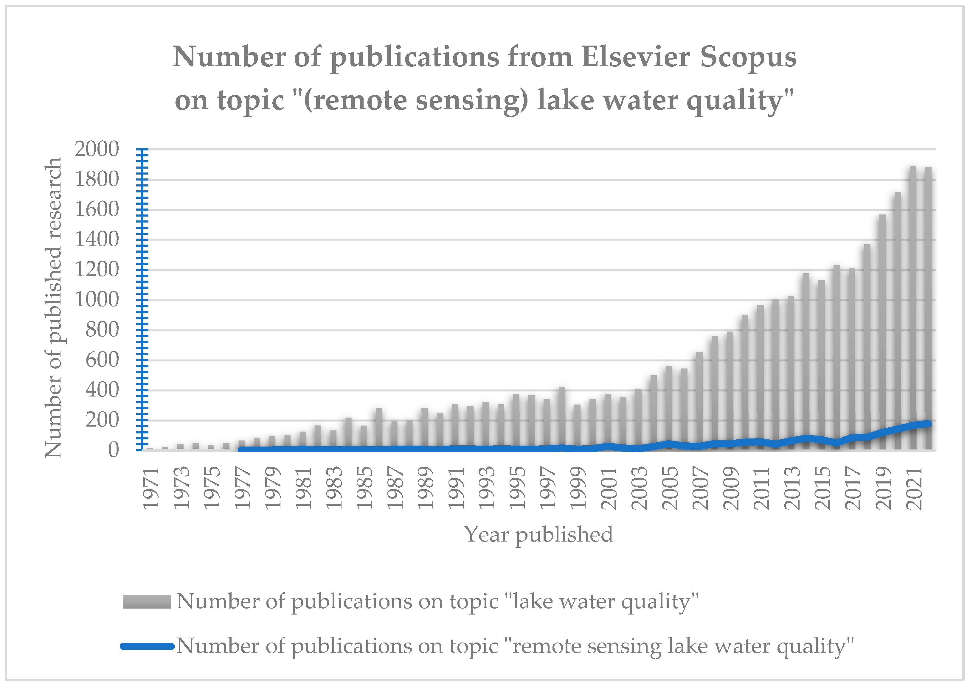
Figure 2.
Visualization of documents per country of origin (showing only records for more than 30 documents per country).
Figure 2.
Visualization of documents per country of origin (showing only records for more than 30 documents per country).
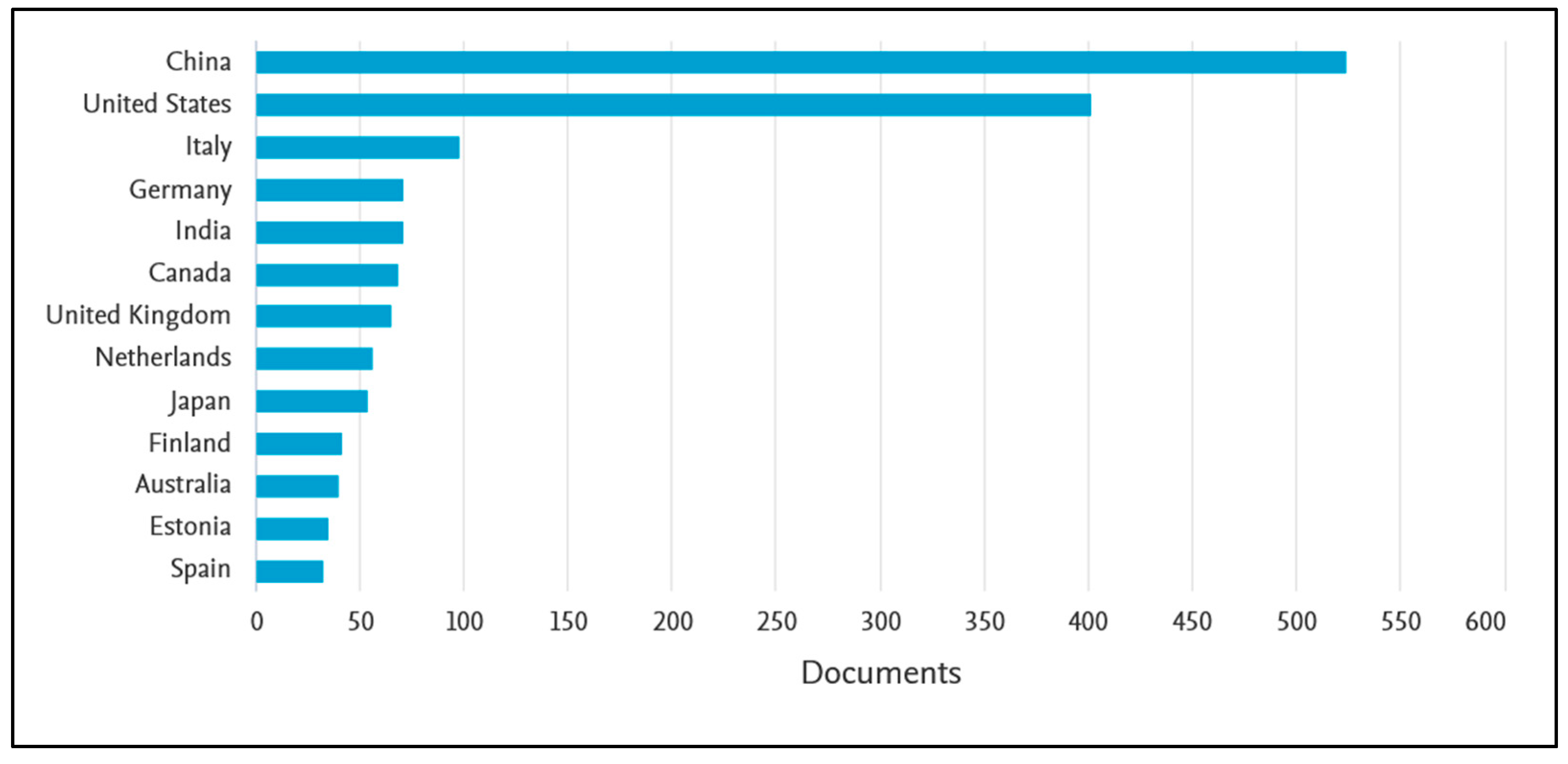
Figure 3.
Visualization of number of publications selected from Elsevier Scopus by waterbody as mentioned in the publication’s abstract.
Figure 3.
Visualization of number of publications selected from Elsevier Scopus by waterbody as mentioned in the publication’s abstract.
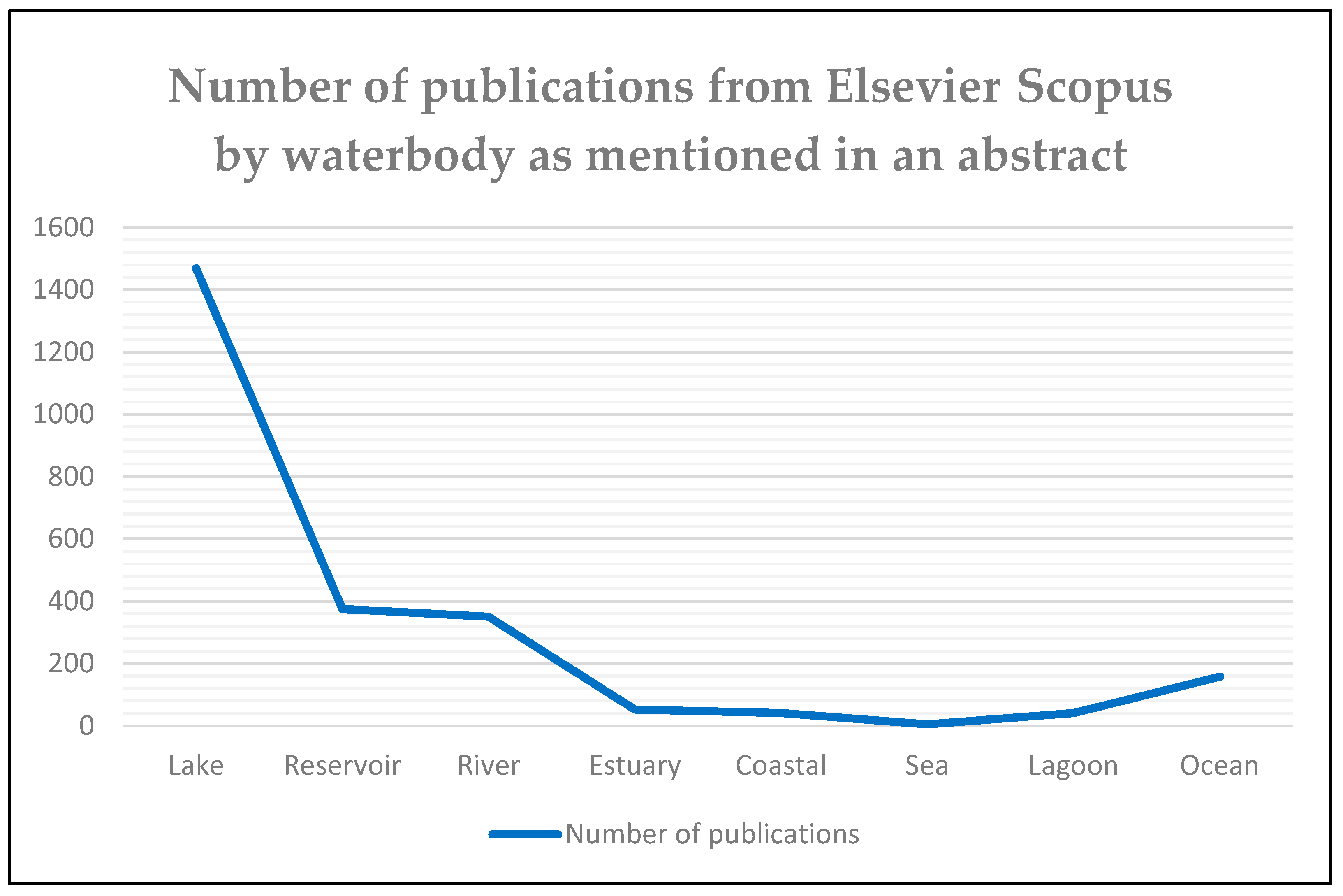
Figure 4.
Schematic overview of the path of electromagnetic spectrum between the Sun, a waterbody, and a sensor.
Figure 4.
Schematic overview of the path of electromagnetic spectrum between the Sun, a waterbody, and a sensor.
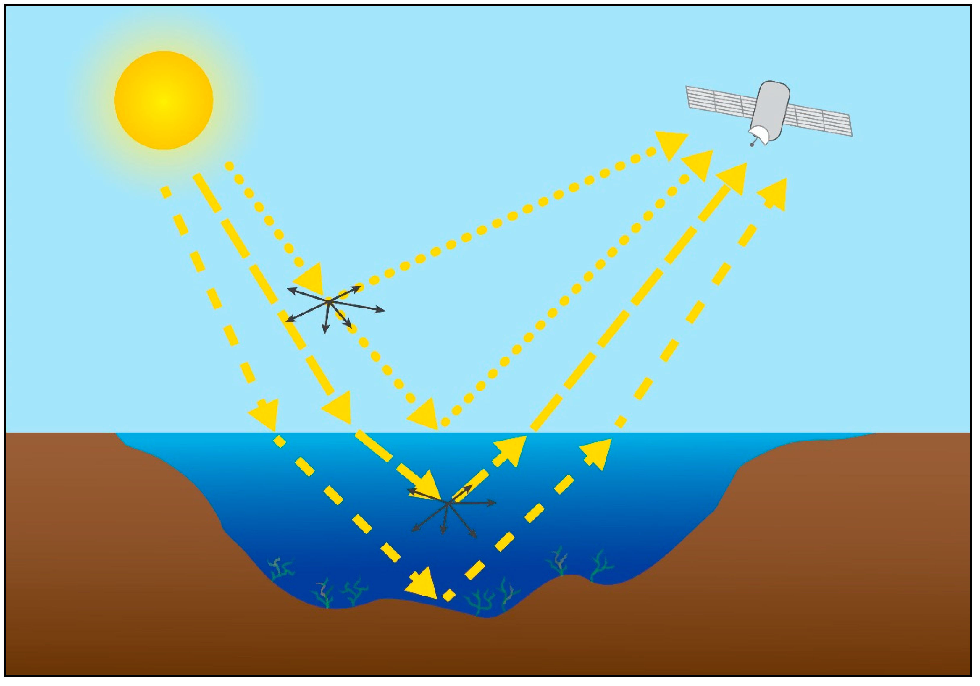
Figure 5.
Reflectance (relationship between reflected energy and total incident energy) according to the typical wavelength of continental water and the spectroscopic signatures of the water quality parameters [341].
Figure 5.
Reflectance (relationship between reflected energy and total incident energy) according to the typical wavelength of continental water and the spectroscopic signatures of the water quality parameters [341].
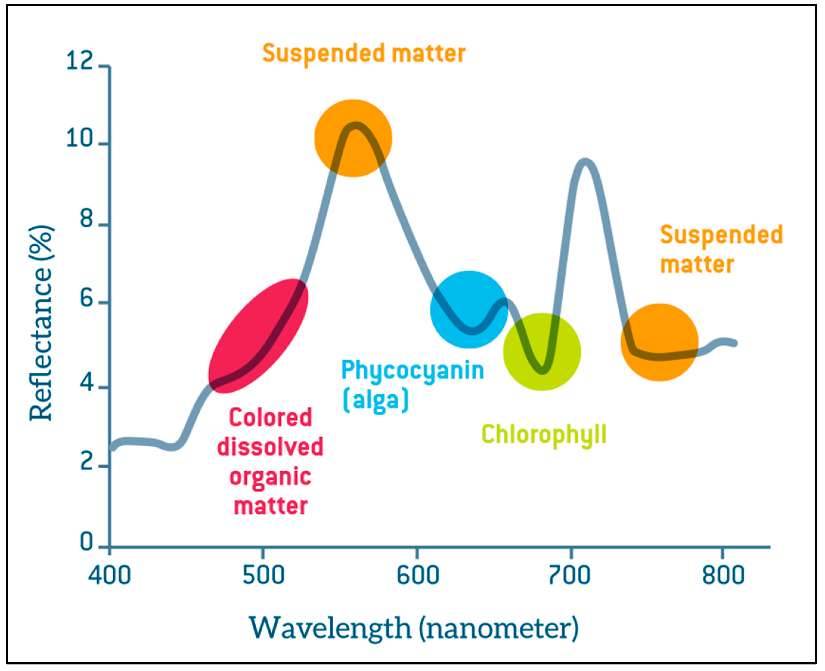
Figure 6.
Different kinds of Secchi disks – a marine style on the left and the freshwater version on the right.
Figure 6.
Different kinds of Secchi disks – a marine style on the left and the freshwater version on the right.
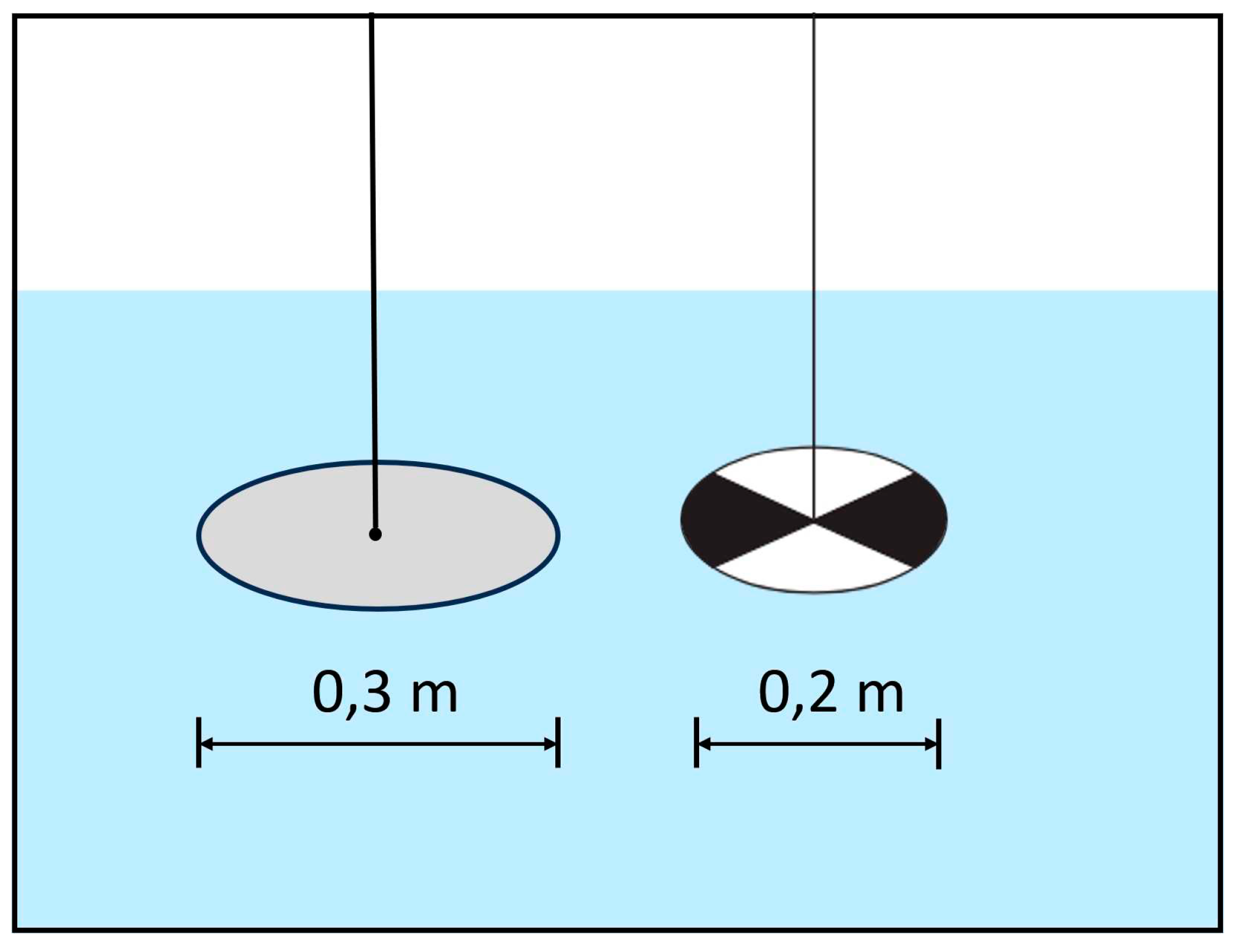

Table 1.
A list of water parameters researched in this review – an emphasis is given on optically active biological and physical indicators (chemical indicators stated in italics are mentioned throughout the review but are not explained in detail).
Table 1.
A list of water parameters researched in this review – an emphasis is given on optically active biological and physical indicators (chemical indicators stated in italics are mentioned throughout the review but are not explained in detail).
| Water Quality Parameter | Abbreviation | Units | Optical Activity | Type |
|---|---|---|---|---|
| Chlorophyll-α | chl-α | mg/L | Active | Biological |
| Transparency (Secchi Disk Depth) | SDD | m | Active | Physical |
| Colored Dissolved Organic Matters | CDOM | mg/L | Active | Physical |
| Electrical Conductivity | EC | µS/cm | Active | Physical |
| Turbidity | TUR | NTU | Active | Physical |
| Surface Salinity | SS | PSU | Active | Physical |
| Total Suspended Matters | TSM | mg/L | Active | Physical |
| Water temperature | WT | °C | Active | Physical |
| pH | pH | - | Active | Chemical |
| Total Organic Carbon | TOC | mg/L | Active | Chemical |
| Dissolved Oxygen | DO | mg/L | Inactive | Chemical |
| Chemical Oxygen Demand | COD | mg/L | Inactive | Chemical |
| Biochemical Oxygen Demand | BOD | mg/L | Inactive | Chemical |
| Total Nitrogen | TN | mg/L | Inactive | Chemical |
| Ammonia Nitrogen | NH3-N | mg/L | Inactive | Chemical |
| Total Phosphorus | TP | mg/L | Inactive | Chemical |
| Orthophosphate | PO4 | mg/L | Inactive | Chemical |
Disclaimer/Publisher’s Note: The statements, opinions and data contained in all publications are solely those of the individual author(s) and contributor(s) and not of MDPI and/or the editor(s). MDPI and/or the editor(s) disclaim responsibility for any injury to people or property resulting from any ideas, methods, instructions or products referred to in the content. |
© 2023 by the authors. Licensee MDPI, Basel, Switzerland. This article is an open access article distributed under the terms and conditions of the Creative Commons Attribution (CC BY) license (http://creativecommons.org/licenses/by/4.0/).
Copyright: This open access article is published under a Creative Commons CC BY 4.0 license, which permit the free download, distribution, and reuse, provided that the author and preprint are cited in any reuse.


