Submitted:
15 August 2023
Posted:
17 August 2023
You are already at the latest version
Abstract
This research focuses on monitoring the spatiotemporal changes of urban surface water in Dhaka City from 1990 to 2021, utilizing satellite imagery and the Google Earth Engine (GEE) platform. Surface water is essential for urban, environmental, and agricultural ecosystems, and its dynamics have significant implications for water resource planning and environmental management. The main objectives of this study are to assess the extent of urban surface water coverage over the last three decades and identify trends of water loss or gain in the study area. The study employs Landsat 5 TM and Landsat 8 OLI/TIRS imagery, integrating GEE with machine learning coding and WRI techniques to extract and analyze surface water data efficiently. Traditional remote sensing methods for dynamic monitoring are time-consuming and cumbersome, but GEE offers a user-friendly and accurate approach, providing easy access to satellite data and cloud-based processing. The results reveal a concerning trend in urban surface water coverage, indicating a significant reduction from 36.23 km² in 1990 to 5.83 km² in 2021, representing a loss of approximately 20 square kilometers or 45 percent of surface water over the last three decades. The decline is attributed to factors such as unplanned urban expansion, rapid real estate development, and increased industrial and economic activities in the study area. The developed algorithms utilizing GEE offer valuable insights into the maximum and minimum extent of surface water, enabling effective surface water planning and management. These findings contribute to sustainable water resource management and environmental preservation in Dhaka City.
Keywords:
Urban Surface Water
; Spatiotemporal Changes
; Satellite Imagery
; Google Earth Engine (GEE)
1. Introduction
Increasing demands for water use, surface energy balance, eco-system functioning, ground water recharge, and economic growth all highlight the need of water sustainability in the context of human civilization [1]. Rapid urbanization, dwindling supplies of fresh water and other natural resources, etc., are only some of the problems facing many nations today. These issues are more prevalent in third world countries like Bangladesh [2].
Due to uncontrolled urbanization and population increase in recent decades, Dhaka has rapidly become a metropolis. Unfortunately, this uncontrolled expansion has degraded the environment, notably climate and water quality and availability [3]. Potable water shortages are already a result of uncontrolled growth. Lakes and ponds were part of the city’s ecosystem and culture in the past. These water bodies helped drain the city, move people, and provide agricultural water. Given this, annual water body assessments are essential for urban environmental planning [3,4]. This study uses Google Earth Engine to locate and quantify urban surface water coverage during the past 30 years.
Water resources assessments in the field are laborious and expensive due to the harsh natural environment, and consistent long-term data series are hard to find. Satellite remote sensing can easily and accurately monitor water bodies on a vast scale [5]. Remote sensing satellite technology solves water resources, earth science, and irrigation planning problems. Following the spectral properties of the water system, numerous satellite-based water removal indices have been devised to easily remove water from remote sensing images.
Landsat 5 TM and Landsat 8 OLI/TIRS data were used to analyses the impact of urbanization on surface water bodies in Dhaka using the Water Ratio Index (WRI). Water extraction band indices for multispectral data are available now. WRI is one [4]. This approach detected water bodies and determined threshold values using reflectance values in Blue, Green, Red, NIR, MIR, and SWIR electromagnetic spectrum bands. Landsat 8 outperformed Landsat 5 in spatial resolution, radiometric sensitivity, and dynamic range for Earth observation [6]. The WRI method quantified Dhaka’s urbanization’s influence on water bodies.
Moreover, this study takes a unique approach to surface water research, offering a fresh perspective on the distribution and dynamics of water resources. The findings will be used to develop tools in the Google Earth Engine for evaluating and monitoring water resources. Additionally, the study provides useful recommendations for conserving and sustainably managing water resources in the study area.
2. Aims and Objectives:
The main objective of this research is to assess the spatiotemporal changes in urban surface water in Dhaka City from 1990 to 2021 using satellite imagery and the Google Earth Engine (GEE) platform. Historical imagery data is used to assess surface water coverage over the last three decades and determine water loss or gain trends in the research area. GEE will use advanced algorithms and machine learning coding to effectively and accurately extract surface water data from satellite pictures to assess urban water body dynamics. The research also examines the origins and drivers of urban surface water changes, including unplanned urban expansion, real estate development, increased industrial activity, and climate change. These findings are essential for building Dhaka City’s water management and sustainable urban development policies.
3. Materials and Methods
3.1. Study Area
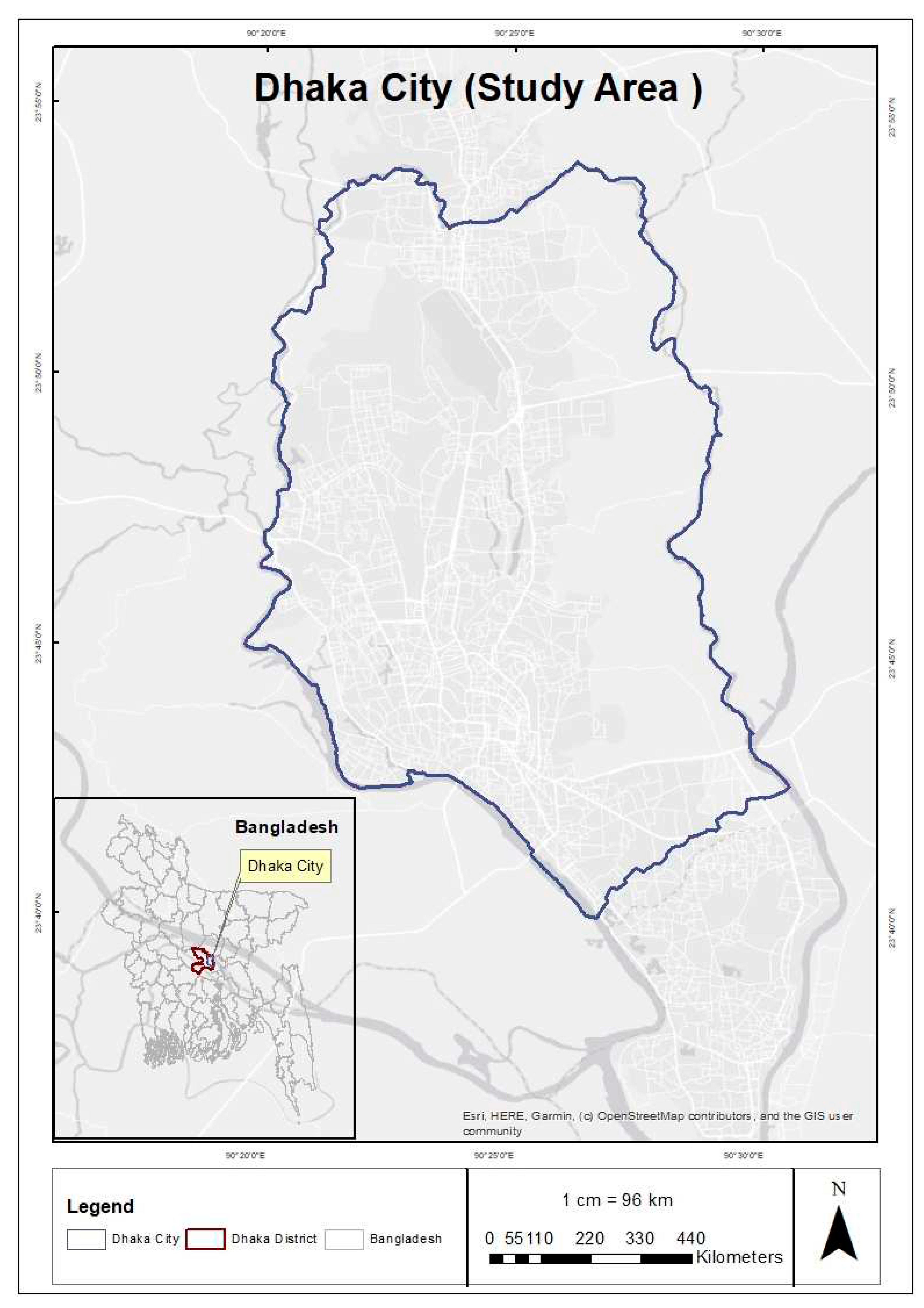
Dhaka city, the bustling capital of Bangladesh, is a densely populated urban hub with a staggering population of over 21 million, encompassing an area of 306.38 square kilometers (118.29 sq mi). Positioned at 23°42′N 90°22′E in central Bangladesh, the city lies along the eastern banks of the Buriganga river, southern banks of Turag, western bank of Balu, and north-western bank of Shitalakshya rivers. Dhaka is strategically situated in the fertile region of the Ganges Delta, teeming with agricultural potential [7].
While the exact count of water bodies within Dhaka city remains unknown, estimates suggest there are more than 400 water bodies within its boundaries. However, the rapid pace of urbanization and human activities have put these water bodies under significant threats, including pollution, encroachment, and reduced water flow [8]. The importance of water-related issues in Dhaka metropolis makes it necessary to investigate and monitor surface water resource spatiotemporal variations. Therefore, the Water Ratio measure (WRI) is a useful spectral measure for detecting and monitoring surface water bodies using satellite data. Calculating the WRI provides vital information on surface water dynamics in the research area, which aids water resource management and environmental protection [9].
Growing urbanization and development constraints on Dhaka make such investigations urgent. Understanding surface water resource changes can help make informed decisions and execute successful measures to protect these precious natural resources [10]. To maintain the sustainable growth and well-being of Dhaka’s residents, development and water conservation must be balanced.
Figure 1.
Study Area Map.
3.2. Data Acquisition and Processing using GEE Platform
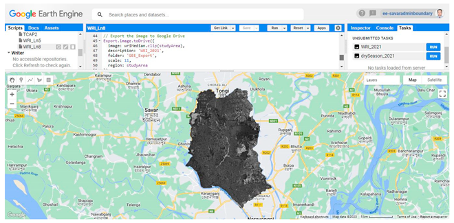
Google Earth Engine (GEE) is a powerful cloud-based platform designed to streamline data processing and analysis for geoscientists. It offers a host of online programming tools and interactive display capabilities, eliminating the need to download remote sensing images for analysis [11]. GEE’s cutting-edge computing power and comprehensive API documentation make it especially well-suited for large-scale and long-term research projects involving vast amounts of remote sensing data, even reaching the PB (petabyte) level [12].
One of GEE’s key strengths lies in its extensive API library, which includes a multitude of advanced remote sensing image processing algorithms. This makes the platform remarkably user-friendly for those prioritizing efficient data processing without extensive programming knowledge [13]. To visualize the Landsat 5 TM data from 1990, 2000, and 2010, alongside Landsat 8 OLI/TIRS data from 2021, the GEE platform was employed using code. Specifically, satellite images captured during the dry season, which typically falls between December to February in the study area, were selected for analysis. These images were pre-processed within GEE to identify the minimum cloud cover or cloud-free images. Subsequently, the image set was clipped to the study area’s boundary [4].
The GEE platform visualized the Water Ratio Index (WRI) generated using a formula to detect water bodies in the picture. WRI can detect even small amounts of water due to its great sensitivity to water content changes. WRI is better at distinguishing water bodies from non-water features like bare soil, metropolitan areas, and barren countryside [12]. When identifying water bodies in complicated landscapes with mixed land cover, this better discriminating can be helpful. By using reflectance disparities between green, red, near-infrared, and medium-infrared bands, the WRI index may identify water bodies. Waterbodies reflect more in the green and red bands than the near- and medium-infrared frequencies. Water absorbs near- and medium-infrared light but reflects more green and red light, explaining this behavior [14].
The formula for calculating WRI is:
WRI = (Green + Red) / (NIR+MIR)
for Landsat 5, WRI = (Band 2 + Band 3) / (Band 4+Band 5)
for Landsat 8, WRI = (Band 3 + Band 4) / (Band 5+Band 6)
Typically, water bodies exhibit WRI values exceeding 1, while features like vegetation and bare soil tend to have lower WRI values. This distinction arises from the differing reflectance properties of water, vegetation, and soil across various spectral bands. Vegetation and soil typically reflect more light in the near-infrared and medium-infrared bands compared to the green and red bands [15].
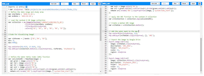
The water ratio index is constructed to leverage the specific spectral characteristics of water, enabling the calculated index to accentuate the contrast between water and other objects. By establishing an appropriate threshold, the index effectively extracts water bodies from the imagery [7]. The development of the water extraction algorithm within the GEE platform has made this process exceptionally convenient and efficient. The coding in GEE, particularly using VB (Visual Basic) and JavaScript, has proven to be highly valuable for advancing water resources management [16].
The utilization of the water ratio index and the coding capabilities in GEE offer a powerful tool for water resource management and analysis. By easily identifying and extracting large areas of surface water, researchers and decision-makers gain valuable insights into water dynamics and availability. Such advances in remote sensing technology and algorithm development provide essential support for the sustainable management and conservation of water resources. The seamless integration of GEE’s programming and spectral analysis tools enables researchers to make informed decisions and address water-related challenges effectively, contributing to the overall development and well-being of communities and ecosystems [17].
Figure 2.
Methodology Flow Diagram.
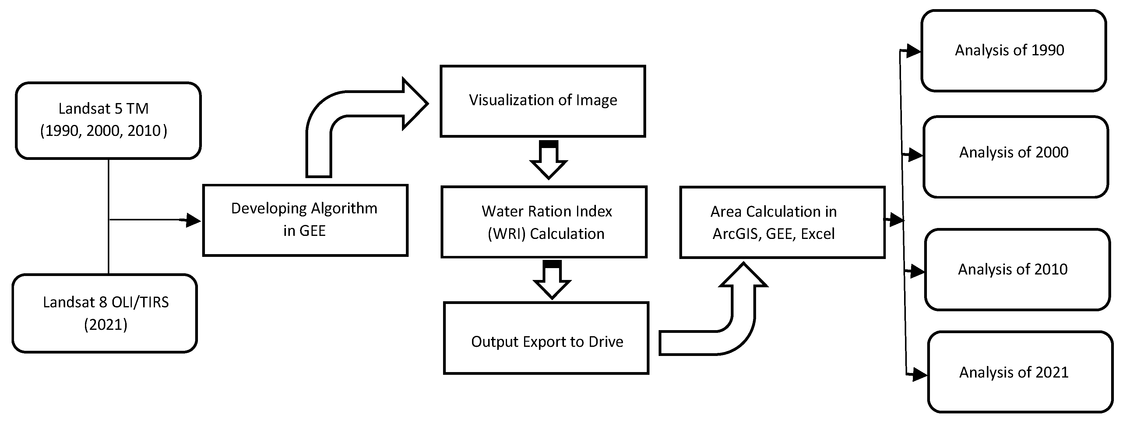
The raster data underwent reclassification into different classes to determine the exact extent of water spread-out in Dhaka city. Using the Arc toolbox, the reclassified raster data were then converted into polygon features, enabling the calculation of water surface coverage area within the study area. This process was repeated for the years 1990, 2000, 2010, and 2021. Subsequently, the water surface areas were quantified, and a more comprehensive analysis was conducted using both ArcGIS and MS Excel to gain deeper insights and interpret the results effectively.
4. Results: Urban Inland Surface Water Identification and Quantification
Google Earth Engine (GEE) revolutionizes remote sensing processing by offering a cloud-based platform with a wide array of remote sensing algorithms, facilitating geoscience data collection and analysis. GEE’s efficiency not only saves time by eliminating the need for image downloading but also reduces work cycles through its powerful interaction capabilities and computational performance. This enables remote sensing scientists to focus more on analysis rather than repetitive processing tasks [18].
GEE’s simple remote sensing image processing extracts vector information from water bodies for hydrological element analysis. This study analyzed Dhaka for 30 years using Landsat 5 and 8 data. Water body index reduces irrelevant ground information and improves water body recognition with numerous bands. This study used the coding and GEE-produced Water Ratio Index (WRI). The WRI index directly eliminated water bodies from other features, providing actual water surface coverage area data. The WRI index for each decade was generated using 1990–2021 December Landsat 5 and 8 data. WRI index was exported to disc and downloaded for processing using Java. These raster data were classified using ArcGIS and transformed into polygons to determine the study area’s annual water coverage.
The results, presented in Figure 3 and Figure 4, showcase the year-wise water coverage area of Dhaka city. This research harnesses the power of GEE and integrates various tools and technologies, enabling a comprehensive understanding of the changing trends in water bodies within Dhaka city over the past three decades. The combination of GEE and ArcGIS facilitates efficient data analysis, providing valuable insights for decision-makers and researchers working on water resource management and urban development in the study area.
Figure 3 in the study focused on water bodies in Dhaka city, the capital of Bangladesh, showcases false color composite (FCC) maps obtained from Landsat 5 and 8 satellite imagery. These maps were created for four specific years: 1990, 2000, 2010, and 2021. The color scheme utilized in the maps effectively highlighted water bodies, represented by shades of blue or dark blue. To generate these maps, a specific combination of bands was chosen, with the near-infrared band represented as red, the shortwave infrared band as green, and the visible blue band as blue. This selection of bands enabled the identification of healthy vegetation in vibrant red, while water bodies appeared as distinctive shades of blue or black. Urban areas, depending on their level of development and vegetation presence, were depicted as varying shades of gray or white.
Moving on to Figure 4, it illustrates the results of the Water Ratio Index (WRI) analysis, which serves as a key metric derived from remote sensing data, particularly Landsat satellite 5 and 8 imagery, to identify and emphasize water areas on the earth’s surface. In this case, the WRI output was generated with a threshold value of 1. As a result, pixels with a WRI value greater than 1 were classified as water, whereas those with lower WRI values were designated as other features like vegetation, roads, or cloud shadows. By utilizing this threshold, the WRI output offers valuable insights into the extent of water bodies in Dhaka city over a span of three decades. This information becomes instrumental in monitoring changes and trends in surface water resources, a critical aspect of water resource management, particularly in rapidly developing urban areas like Dhaka. The city’s fast-paced urbanization and the ever-evolving climate scenario significantly impact water availability and quality, necessitating a proactive approach to water resource management.
Through Figure 3 and Figure 4, the study effectively visualizes the dynamic changes in water bodies within Dhaka city over the past forty years, exposing a notable decline in surface water resources. The rapid urbanization and associated development activities have emerged as the principal drivers of this decline. The information derived from these figures provides valuable data for policymakers and researchers to understand and address the challenges posed by diminishing water resources. It underscores the urgency to adopt sustainable water management strategies, considering the city’s ongoing growth and the potential impacts of climate change. By utilizing remote sensing data and innovative indices like the WRI, this study offers a powerful tool for analyzing and addressing water-related issues in Dhaka city and other similar urban environments facing similar challenges.
Figure 5 illustrates the changes in the dry season surface water coverage area of Dhaka city from 1990 to 2021. The 1990 surface water map identified the existence of various small water bodies, including ponds and small lakes and wetlands of the riverbank, within the city boundaries. These water bodies were mainly located on the outskirts of the city and scattered throughout the central areas, with a majority situated on the eastern and northern sides of the city boundary. On the map blue color represent the water bodies of the study area. However, even at this early stage, the number and size of these water bodies had already begun to decline due to the rapid expansion of urban areas and the construction of new buildings and infrastructure.
Many smaller ponds and lakes vanished by 2000 as water levels dropped. The city’s agricultural borders had the last water features. Few large lakes and reservoirs were visible in the city by 2010, especially in the east and north, where urbanization was lower. The 2021 surface water map shows few public water bodies in Dhaka, with only a few minor ponds and lakes on the outskirts and surrounded by thick urbanization [19]. This loss of aquatic bodies was largely caused by low-lying urbanization and real estate development. Despite preservation efforts, urbanization and development threaten surviving water bodies.
5. Discussion:
Over the past few decades, Dhaka city has undergone significant growth in population and economic prosperity. However, this rapid increase in population has posed a threat to the city’s surface water coverage, leading to an ecological imbalance. The total area of Dhaka city stands at 306.4 sq. km [20], and this study utilized the water ratio index (WRI) to determine the extent of urban land surface and water surface.
In 1990, the total land surface covered 270.17 sq. km, with the water surface area spanning 26.23 sq. km. A decade later, in 2000, the land surface coverage expanded slightly to 273.41 sq. km, while the water surface area decreased to 32.99 sq. km. By 2010, the total land surface increased to 277.73 sq. km, while the water surface further decreased to 28.67 sq. km. Finally, in 2021, the land surface coverage reached 290.58 sq. km, whereas the water surface coverage dwindled to 15.82 sq. km.
Throughout the last three decades, the data reveals a clear pattern: the land surface coverage exhibited a consistent upward trend, reflecting the city’s rapid urbanization and development. Conversely, the water surface coverage experienced a steady decline over the same period, highlighting the pressing issue of diminishing surface water in Dhaka.

Table 1.
Details of surface coverage area.
| Land Coverage/Year | 1990 | 2000 | 2010 | 2021 |
|---|---|---|---|---|
| Land Surface | 270.17 | 273.41 | 277.73 | 290.58 |
| Water Surface | 36.23 | 32.99 | 28.67 | 15.82 |
| Total | 306.4 | 306.4 | 306.4 | 306.4 |
The provided bar graph, Figure 6, presents a comparative analysis of the urban land and water surface percentages from 1990 to 2021, as determined by this study. In 1990, the land surface accounted for 88.18%, while the water surface made up 11.82%. By 2000, the land surface percentage increased to 89.23%, with the water surface percentage decreasing to 10.77%. In 2010, the trend continued, with the land surface occupying 90.64% and the water surface shrinking to 9.36%. Finally, in 2021, the land surface percentage surged to 94.84%, leaving only 5.16% for water surface. The study highlights a notable decline in water surface over the last few decades, signifying a significant shift in the city’s landscape.
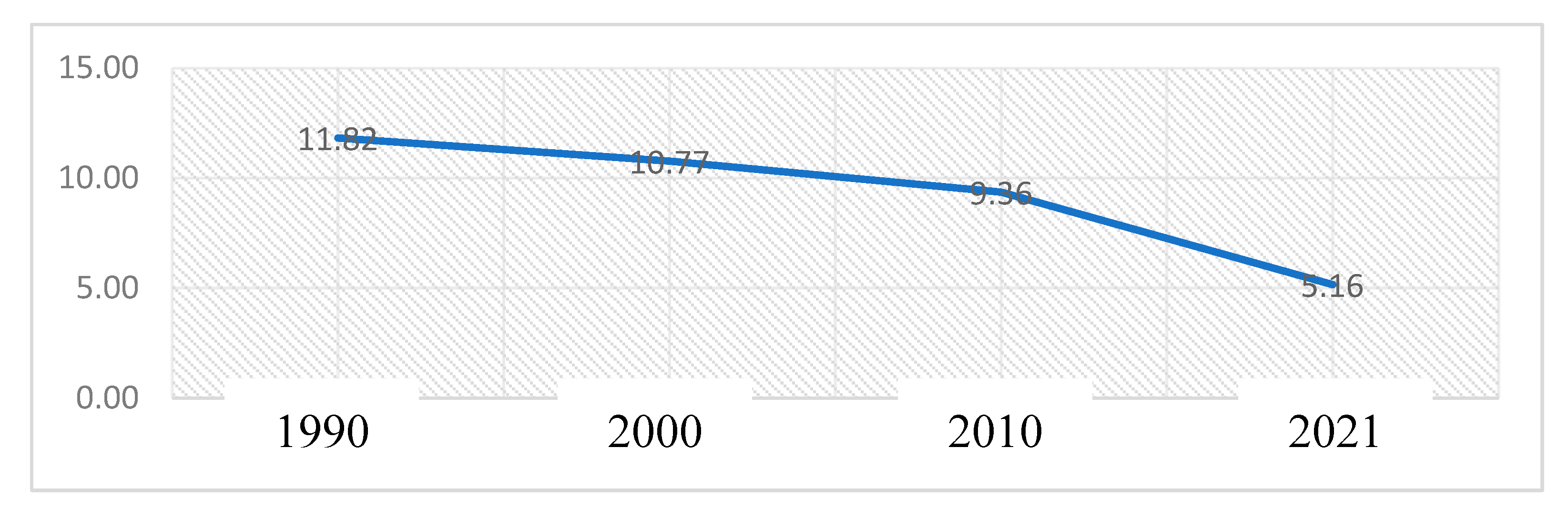
Figure 7 displays a line graph depicting the evolving patterns of urban surface water coverage in Dhaka city from 1990 to 2021. In 1990, approximately 12% of the total coverage area was occupied by water surfaces. Over the next decade, this proportion slightly decreased to around 10%. Subsequently, in the following decade, it further declined to 9%. However, the most significant change occurred in the last decade, with urban surface water coverage experiencing a rapid and drastic decrease, reaching around 5% by the year 2021.This study’s findings indicate that over the course of the last three decades, urban surface water coverage has undergone a substantial transformation, reducing almost by half. Over the past three decades, Dhaka city has witnessed a loss of approximately 20 square kilometers or nearly 44 percent of its surface water.
Over the past three decades, the gradual decrease in water bodies in Dhaka city during the dry season has become evident. Experts suggest that an ideal city should have surface water covering at least 15 percent of its area. However, overcrowded Dhaka falls far short of this benchmark, with bodies of water accounting for only 5.16 percent of its total area, as indicated by this study. Unfortunately, the share of surface water in the capital city of Bangladesh has continued to decline. This downward trend can be attributed to the rapid expansion of urban areas and the relentless construction of new buildings and infrastructure, which have encroached upon natural water bodies.
The loss of these water bodies has far-reaching consequences for both the environment and the city’s residents. Reduced water availability poses challenges for the local population, while the risk of flooding increases due to the diminishing capacity of natural water reservoirs to absorb excess rainfall. In recent years, Dhaka’s dwellers have experienced extreme heat, which environmentalists attribute to the shrinking water bodies. Water surfaces play a crucial role in balancing the urban heat island effect, a function that is also carried out by vegetation. The declining water bodies exacerbate the urban heat island effect, leading to uncomfortable living conditions and potential health hazards for the city’s inhabitants [21].
Given these challenges, it is imperative to prioritize the conservation and restoration of water bodies in Dhaka city. Such efforts are crucial not only for environmental protection but also for the well-being and quality of life of its residents. By safeguarding these valuable natural resources, the city can better mitigate the impacts of climate change, reduce heat stress, and ensure a sustainable and resilient future for Dhaka and its inhabitants.
6. Conclusions
Surface water resource changes affect climate change, environmental balance, and agricultural development in the studied area. Human activities have driven surface water changes, affecting surface temperature, soil moisture, biodiversity, ecosystem functioning, and human well-being. Therefore, dynamic surface water monitoring is essential for planning a healthy environment and sustainable economic growth [22].
While previous research has explored surface water extraction and monitoring using traditional methods, the current study focuses on employing machine learning programming through Google Earth Engine (GEE). By calculating the Water Ratio Index (WRI) based on GEE, the study successfully extracts water body data at appropriate thresholds for different years, such as 1990, 2000, 2010, and 2021, revealing water area coverages of 36.23, 32.99, 28.67, and 5.83 km², respectively. This novel approach proves beneficial in monitoring surface water within the study area.
Trends in urban water surface provide insights on water quantity swings. It helps relevant departments make educated judgements and build conservation and management policies. This study’s use of Google Earth Engine gives surface water research a fresh perspective, enabling water resource distribution and dynamics analysis. This work improves surface water dynamics understanding and helps develop sustainable water resource management techniques.
Conflict of Interest
The authors declare that they have no conflict of interest.
Appendix
GEE Code for Assessing Satellite Image:
Output-01
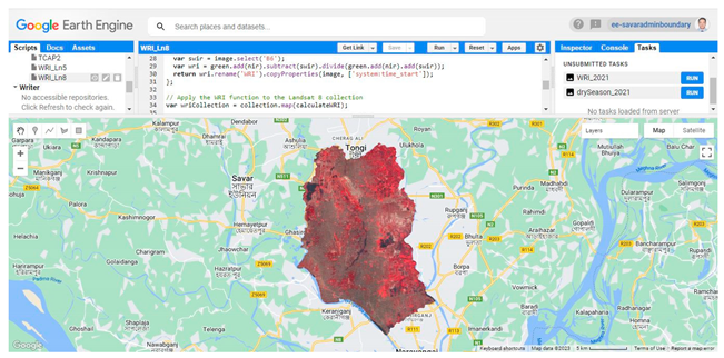
Output-02
References
- Water and Ecosystems. 6 August 2022. Available online: https://www.unwater.org/water-facts/water-and-ecosystems.
- Hayashi, M.; Rosenberry, D.O. Effects of Ground Water Exchange on the Hydrology and Ecology of Surface Water. Ground Water 2022, 40, 309–316. [Google Scholar] [CrossRef] [PubMed]
- Mahbubur Rahman, M.; Hassan, M.S.; Md. Bahauddin, K.; Khondoker Ratul, A.; Hossain Bhuiyan, M.A. Exploring the impact of rural–urban migration on urban land use and land cover: a case of Dhaka city, Bangladesh. Migr. Dev. 2017, 7, 222–239. [Google Scholar] [CrossRef]
- Kandekar, V.U.; Pande, C.B.; Rajesh, J.; Atre, A.A.; Gorantiwar, S.D.; Kadam, S.A.; Gavit, B. Surface water dynamics analysis based on sentinel imagery and Google Earth Engine Platform: a case study of Jayakwadi dam. Sustain. Water Resour. Manag. 2021, 7. [Google Scholar] [CrossRef]
- Arikan, D.; Yildiz, F. Investigation of Antalya forest fire’s impact on air quality by satellite images using Google earth engine. Remote Sens. Appl. Soc. Environ. 2023, 29, 100922. [Google Scholar] [CrossRef]
- Verpoorter, C.; Kutser, T.; Tranvik, L. Automated mapping of water bodies using Landsat multispectral data. Limnol. Oceanogr. Methods 2012, 10, 1037–1050. [Google Scholar] [CrossRef]
- Yin, H.; Islam, M.S.; Ju, M. Urban river pollution in the densely populated city of Dhaka, Bangladesh: Big picture and rehabilitation experience from other developing countries. J. Clean. Prod. 2021, 321, 129040. [Google Scholar] [CrossRef]
- Sultana, M.S.; Tarekul Islam, G.M.; Islam, Z. Pre- and Post-Urban Wetland Area in Dhaka City,Bangladesh: A Remote Sensing and GIS Analysis. J. Water Resour. Prot. 2009, 1, 214–421. [Google Scholar] [CrossRef]
- Ahsan, A.; Ahmed, T.; Uddin, M.A.; Al-Sulttani, A.O.; Shafiquzzaman, M.; Islam, M.R.; Masria, A. Evaluation of Water Quality Index (WQI) in and around Dhaka City Using Groundwater Quality Parameters. Water 2023, 15, 2666. [Google Scholar] [CrossRef]
- Azharul Haq, K. Water Management in Dhaka. Int. J. Water Resour. Dev. 2006, 22, 291–311. [Google Scholar] [CrossRef]
- Amani, M.; Ghorbanian, A.; Ahmadi, S.A.; Kakooei, M.; Moghimi, A.; Mirmazloumi, S.M.; Brisco, B. Google Earth Engine Cloud Computing Platform for Remote Sensing Big Data Applications: A Comprehensive Review. IEEE J. Sel. Top. Appl. Earth Obs. Remote Sens. 2020, 13, 5326–5350. [Google Scholar] [CrossRef]
- Yang, L.; Driscol, J.; Sarigai, S.; Wu, Q.; Chen, H.; Lippitt, C.D. Google Earth Engine and Artificial Intelligence (AI): A Comprehensive Review. Remote Sens. 2022, 14, 3253. [Google Scholar] [CrossRef]
- Annala, L.; Eskelinen, M.A.; Hämäläinen, J.; Riihinen, A.; Pölönen, I. PRACTICAL APPROACH FOR HYPERSPECTRAL IMAGE PROCESSING IN PYTHON. Int. Arch. Photogramm. Remote Sens. Spat. Inf. Sci. 2018, XLII-3, 45–52. [Google Scholar] [CrossRef]
- Khalid, H.W.; Khalil, R.M.Z.; Qureshi, M.A. Evaluating spectral indices for water bodies extraction in western Tibetan Plateau. Egypt. J. Remote Sens. Space Sci. 2021, 4, 619–634. [Google Scholar] [CrossRef]
- Laonamsai, J.; Julphunthong, P.; Saprathet, T.; Kimmany, B.; Ganchanasuragit, T.; Chomcheawchan, P.; Tomun, N. Utilizing NDWI, MNDWI, SAVI, WRI, and AWEI for Estimating Erosion and Deposition in Ping River in Thailand. Hydrology 2023, 10, 70. [Google Scholar] [CrossRef]
- Liu, S.; Wu, Y.; Zhang, G.; Lin, N.; Liu, Z. Comparing Water Indices for Landsat Data for Automated Surface Water Body Extraction under Complex Ground Background: A Case Study in Jilin Province. Remote Sens. 2023, 15, 1678. [Google Scholar] [CrossRef]
- Li, X.; Zhang, F.; Chan, N.W.; Shi, J.; Liu, C.; Chen, D. High Precision Extraction of Surface Water from Complex Terrain in Bosten Lake Basin Based on Water Index and Slope Mask Data. Water 2022, 14, 2809. [Google Scholar] [CrossRef]
- Tamiminia, H.; Salehi, B.; Mahdianpari, M.; Quackenbush, L.; Adeli, S.; Brisco, B. Google Earth Engine for geo-big data applications: A meta-analysis and systematic review. ISPRS J. Photogramm. Remote Sens. 2020, 164, 152–170. [Google Scholar] [CrossRef]
- Islam, M.S.; Shahabuddin, A.; Kamal, M.M.; Ahmed, R. Wetlands of Dhaka City: Its Past and Present Scenario. J. Life Earth Sci. 2014, 7, 83–90. [Google Scholar] [CrossRef]
- Dewan, A.M.; Kabir, M.H.; Nahar, K.; Rahman, M.Z. Urbanisation and environmental degradation in Dhaka Metropolitan Area of Bangladesh. Int. J. Environ. Sustain. Dev. 2012, 11, 118. [Google Scholar] [CrossRef]
- Thiele-Eich, I.; Burkart, K.; Simmer, C. Trends in Water Level and Flooding in Dhaka, Bangladesh and Their Impact on Mortality. Int. J. Environ. Res. Public Health 2015, 12, 1196–1215. [Google Scholar] [CrossRef]
- Abbass, K.; Qasim, M.Z.; Song, H.; Murshed, M.; Mahmood, H.; Younis, I. A review of the global climate change impacts, adaptation, and sustainable mitigation measures. Environ. Sci. Pollut. Res. 2022, 29, 42539–42559. [Google Scholar] [CrossRef] [PubMed]
Figure 3.
Water bodies identified using false color composite from 1990 to 2021.
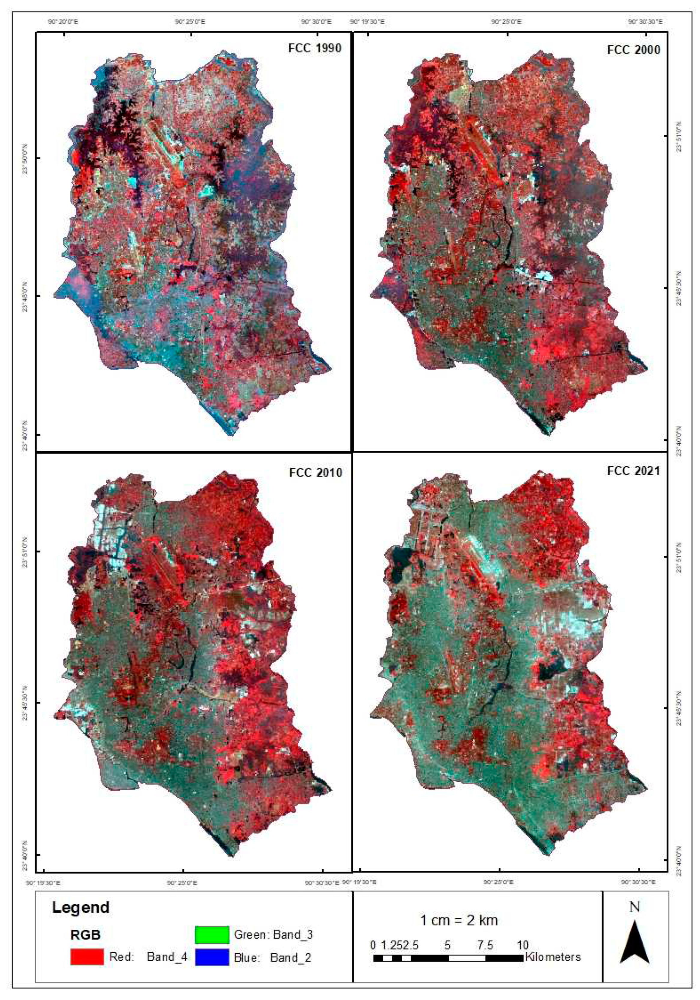
Figure 4.
The water bodies of identified using Water Ratio Index (WRI) from 1990 to 2021.
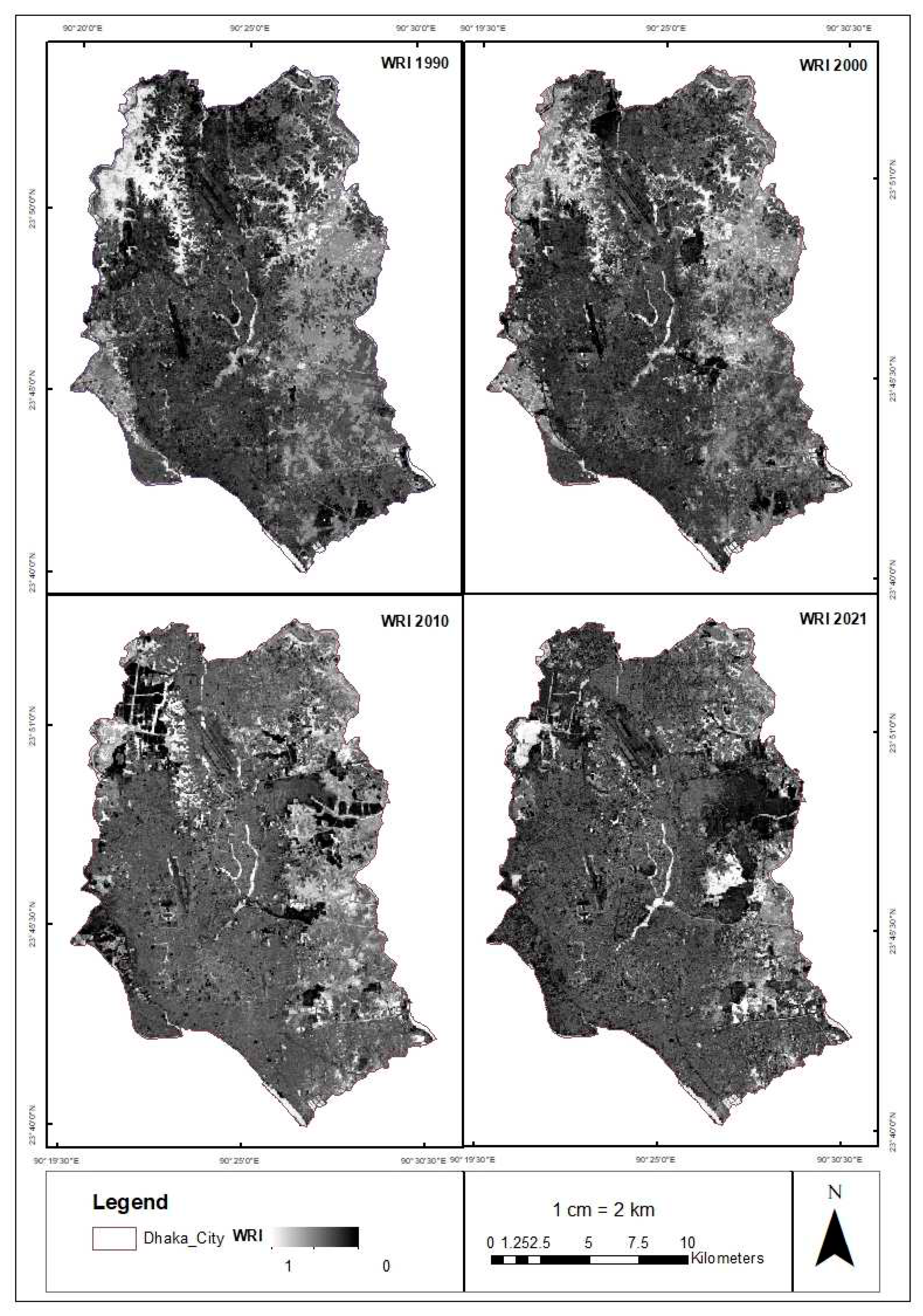
Figure 5.
Inland surface water spread out area (Dry Season) of Dhaka city from 1990 to 2021.
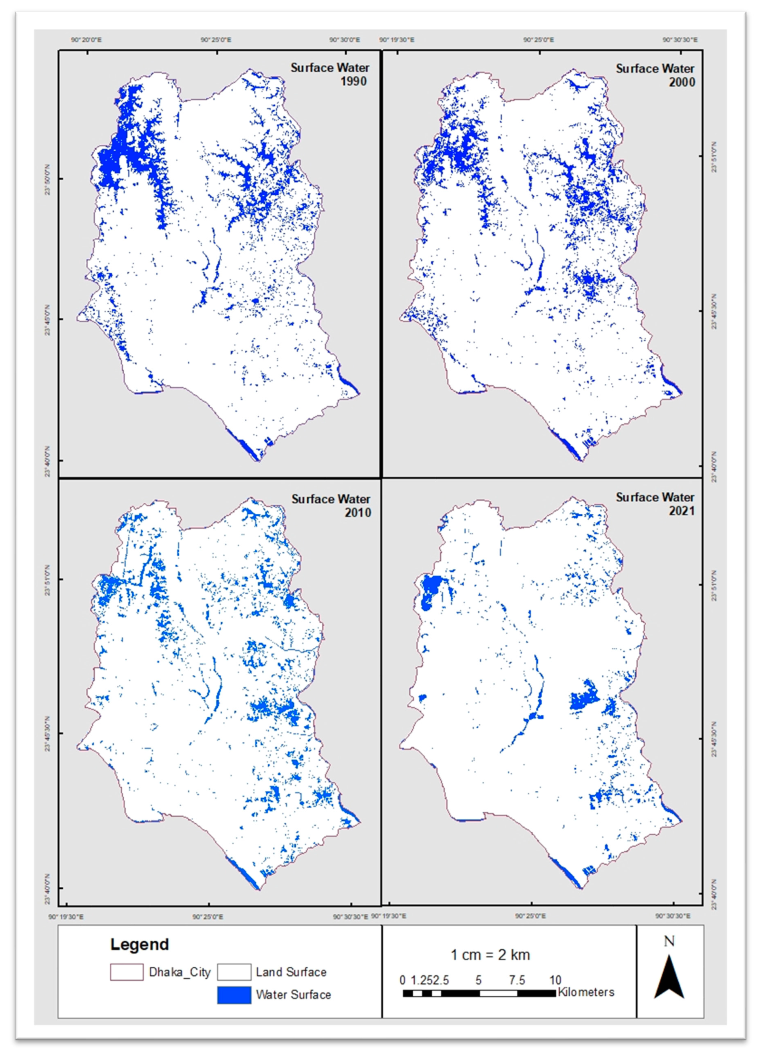
Figure 6.
Year wise urban surface coverage area of Dhaka city.
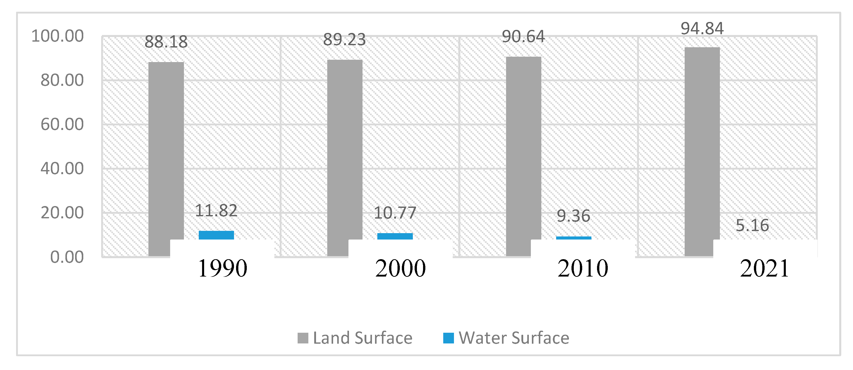
Figure 7.
Changing trends urban surface water of Dhaka city.
Disclaimer/Publisher’s Note: The statements, opinions and data contained in all publications are solely those of the individual author(s) and contributor(s) and not of MDPI and/or the editor(s). MDPI and/or the editor(s) disclaim responsibility for any injury to people or property resulting from any ideas, methods, instructions or products referred to in the content. |
© 2023 by the authors. Licensee MDPI, Basel, Switzerland. This article is an open access article distributed under the terms and conditions of the Creative Commons Attribution (CC BY) license (http://creativecommons.org/licenses/by/4.0/).
Copyright: This open access article is published under a Creative Commons CC BY 4.0 license, which permit the free download, distribution, and reuse, provided that the author and preprint are cited in any reuse.


