
Submitted:
14 July 2023
Posted:
18 July 2023
You are already at the latest version
Abstract
The North Railway in the Kingdom of Saudi Arabia (KSA) extends over vast areas, crossing various terrains, including valleys, sand veins, plateaus, and hills. Therefore, the Railway was designed and implemented to suit this environmental diversity under the highest safety standards. However, the Railway may be subject to hazards for various reasons. In general, the possibility of direct surface runoff disasters increases if there are residential areas and facilities within the boundaries of drainage basins. Therefore, these areas should be studied, and the degree of hazard in drainage basins should be accurately determined. Hence, this study analyzed the degree of risk of 14 drainage basins affecting the North Train railway within the Wadi Malham drainage basin, using the risk degree model with eight parameters that have hydrological indications to give an idea of the behavior of direct surface runoff and interfere with increasing the risk of direct surface runoff. Researchers found 28.57% of the total basins in the study area have high-risk basin overall score values, which are basins 6, 7, 13, and 14. It is recommended to estimate the rainfall depth during different return periods, analyze soil permeability and land use classification in the study area, and apply hydrological modeling of drainage basins, which contributes to estimating the volume and peak of direct surface runoff in such arid and semi-arid environments that do not contain hydrometric stations to monitor the runoff. .
Keywords:
Geographic information system
; drainage Basins
; morphometric analysis
; hazard Degree
; north railway
; Wadi Malham
; ALOS PALSAR
1. Introduction
The railway network in KSA consists of lines for transporting passengers, goods, petrochemical products, petroleum, and minerals. The North Railway is one of the pillars of this system, as it consists of a line for passengers that is 1250 km long in addition to a 1550 km shipping line [1]. Any transportation will contribute to and impact the development of counties by connecting cities with each other [2]. The North Railway connected five regions, starting from Riyadh, the capital of Saudi Arabia, to the end of the north border of the county, which gives access to many cities and countryside without using cars [1]. The North Railway provides access to higher education, employment, and trade exchange [3]. Here lies one of the challenges, as the North Railway extends over vast areas and crosses various terrains, including valleys, sand veins, plateaus, and hills. Therefore, the Railway was designed and implemented to suit environmental diversity according to the highest safety standards. However, the railway may be subject to hazards for multiple reasons. It is likely to be subject to geomorphological and hydrological risks. It depends on the climate and terrain of the area where it is located [4], in addition to human errors that may occur when planning or implementing such projects. The railways in the Kingdom of Saudi Arabia were damaged in various places due to torrential rains. In 2018, a part of the railway of the North Train within the borders of Wadi Bayer Basin in the Qurayyat Governorate was damaged. Also, in 2017, a part of the Riyadh-Dammam railway drifted and caused the train to derail and damage passengers and infrastructure due to direct surface runoff in Dhahran's southern (armored) Valley [4].
Since the thirties of the twentieth century, people have been interested in studying drainage basins as geomorphological units. Then people began using morphometric analysis in analyzing and quantifying drainage networks. Horton, a leader in this field, was the first to conduct this analysis. Afterward, the methods of morphometric analysis, which describe the drainage basins and networks, were developed through research and attempts provided by various researchers, such as (Strahler), (Shreve), (Chorley) and others [5].
Strahler [6] defined morphometrics as "the science of measuring geometric properties of the earth's surface resulting from the river erosion system" [7]. Morphometric measurements are one of the essential geomorphological applications. They provide a database for studying drainage basins' properties and drainage networks' properties and simulating their hydrological behavior [8]. Moreover, these measurements are among the most critical factors affecting the degree of natural hazard, especially the hazard of direct surface runoff in drainage basins [9]. Through these measurements, the features of drainage basins can be understood and their degrees of hazard can be determined [10]. These parameters include the spatial, morphological, and topographic features of the drainage basin and drainage network [11].
It is known that drainage basins in arid and semi-arid environments do not flow throughout the whole year. There is no direct surface runoff for long years, as rain may fall, but most of the water is lost in the soil. However, in other years, the basins may witness rain that is rare in its intensity where there is direct surface runoff, which may cause damage and destruction. In general, the possibility of direct surface runoff disasters increases if there are residential areas and facilities within the boundaries of drainage basins. Therefore, these areas should be studied, and the degree of hazard in drainage basins should be accurately determined.
Many initiatives have emerged by the authorities and ministries to achieve the goals set by the Kingdom of Saudi Arabia within the framework of Vision 2030 for the Kingdom to be among the ranks of developed countries, many of which revolve around ensuring safety and protection for individuals and property, as well as the continued development and sustainability of infrastructure and the improvement of the quality of public facilities and the performance of services [12]. These aspects are considered within the direction and endeavor of this study, and thus the importance of the study is represented in developing an accurate and scientific perception of the degree of danger of direct surface runoff in the drainage basins affecting the North Railway within the Wadi Mulham basin. This study can also be an applied scientific addition to environmental studies that contribute with the authorities related to the planning, development, and protection of railways from the dangers of direct surface runoff.By reading the soil maps covering the study area, which the Ministry of Environment, Water, and Agriculture of Saudi Arabia (1984) produced, it became clear that the soil units within the area are loam soils, and this is a type of hydrological soil group B that is characterized by having moderate to good drainage [13] and contributes to the generation of direct runoff. Based on this information and due to the strategic importance of the North Railway, it can be said that a problem in the study is the lack of analysis of hazard areas around the North Railway in the basin of Wadi Malham. Thus, the study aimed to conduct morphometric analyses using a suitable digital elevation model to analyze drainage basins affecting the North Railway within Wadi Malham, classify the degree of hazard of direct surface runoff in basins, and map direct surface runoff hazards.
2. Classification of Direct Surface Runoff Hazard in Drainage Basins
The most significant direct surface runoff hazard is flooding, along with destruction and damage often caused by floods to many natural and human features. Thus, floods are considered a disaster due to the effects it causes. Thus, it is essential to study and classify the drainage basins based on how hazardous the surface runoff is. Determining priorities helps manage and make good related decisions [14].
2.1. Classification Methods for Direct Surface Runoff Hazards in Drainage Basins
The literature review indicates that researchers used various methods to evaluate the potential hazards of direct surface runoff. These methods are divided into qualitative, semi-quantitative, and quantitative [15]. For example, some researchers apply qualitative methods, such as classifying direct surface runoff hazards and defining them by using qualitative descriptions such as "very high," "high," "medium," "low," and "very low" or alike. These classifications are considered guiding models because they depend on the judgment and experience of the people who make them. Their details depend on historical records of direct surface runoff events in the region [16]. As mentioned by [15], adding weights and ranks to qualitative methods changes them to semi-qualitative methods, including morphometric hazard degree, which is considered to be commonly used in studying the hazards of surface runoffs [17] especially in areas where no hydrometric stations are available[4], in addition to methods mentioned by [18] as multicriteria decision-making (MCDM), including Analytical Hierarchy Process (AHP) [4,19] and Analytic Network Process (ANP), which is similar to AHP but deals with various consequences and interactions in the network [20]. Furthermore, there is also the method of arranging priorities through similarity with (FUZZY TOPSIS) [21].
Concerning quantitative methods, as mentioned by Chen et al., quantitative methods often depend on numerical modeling in analyzing the hazard of direct surface runoff [22], including, for example, hydrologic models [23] and hydraulic models [24,25]; there are statistical methods, which stand as quantitative methods in setting plans of direct surface runoff susceptibility in addition to evaluation of its hazard [26], including, for example, Logistic Regression (LR) [27]. Also, quantitative methods include machine learning, a branch of artificial intelligence, including artificial neural networks (DNN) [17].
As mentioned above, the semi-quantitative methods are used broadly mainly when there is no data of high quality (measured through hydrometric stations), as is the case in the area under study. It is also proven that these methods are helpful for regional and large-scale studies, as mentioned in [28,29,30] and documented by [15]. The method of hazard degree was selected as it is considered one of the most important scientific methods, which contributes to classifying the direct surface runoff hazard in drainage basins, which can be used in drainage basins in arid and semi-arid environments [4].
2.2. Direct Surface Runoff Hazard Studies
Many previous studies, which are directly related to the subject matter of the study, concerning the classification of drainage basins in terms of direct surface runoff hazard degree, were reviewed. This is through applying the hazard degree model on standards and some morphometric measurements of drainage basins and networks. Various researchers used this methodology in studying the direct surface runoff hazard, including the studies [4,17,31,33].
The study [31] aims at evaluating the hazard degree of floods to the main basin and sub-basins of Wadi Al-Leith and determining the adequate procedures of mitigation and methods of using the water of surface runoff in these basins by adopting liner, areal and topographical morphometric characteristics measured by ArcGIS and ASTER with a spatial resolution of 30 meters. 25 morphometric variables were calculated; then, nine morphometric variables were reached, including those morphometric variables with a direct relationship and inverse relationship with flood severity, to apply the model of hazard degree. The study concluded some results and recommendations, the most important of which is that by classifying the hazard categories into three groups; high, moderate, and low-risk, there are five high-risk sub-basins, four low-risk sub-basins, and one moderate sub-basin. One of the most important recommendations of the study is to build dams and barriers in high-risk basins, which do not have an opportunity to feed the groundwater aquifer to benefit from its running water at the intersection points of the fourth and fifth-order sewages. In the study [17] on the evaluation of the hazard of floods and its vulnerability to dry docks, the researchers calculated 14 morphometric variables, which ArcGIS and ASTER also measured with a spatial resolution of 30 meters for 16 fourth-order sub-basins in Wadi Rajil and five sub-basins, which are related to Wadi Al Waheeda in Jordan. 11 morphometric variables were used, including those that have direct and inverse relationships with the severity of floods in order to apply the method of hazard degree. Moreover, three morphometric variables were used to apply the Al Chamy method. Using the two methods, the researchers could evaluate the severity of floods in the drainage basins. One of the most noticeable results concluded in the study was that plans were set which classify the drainage basins to different hazard degrees. Based on the method of hazard degree, the percentage of drainage basins which are highly and severely vulnerable to floods is estimated at 50% of the sub-basins in Wadi Rajil and 80% of the sub-basins in Wadi Al Waheeda. The study recommended that it is necessary to take protective measures in these basins to protect cities, roads, and infrastructure from floods and preserve future development. Elsadek et al. [32] used the same methodology with only a difference in applying the model to three morphometric variables that have a direct relationship only with the severity of floods. They were calculated using the SRTM with a spatial resolution of 90 meters. This is to produce a plan to identify the severity of floods in the 70 sub-basins of Wadi Qena in Egypt. Hazard is classified into five categories. They concluded that the prevailing feature of the hazard degree is the low and moderate risks. The percentage of moderate to high-risk basins is 48.6% of the total number of sub-basins and the percentage of lower-risk sub-basins is 51.4%. In the study of [4], ArcGIS, WMS, and ALOS-PALSAR were used with a spatial resolution of 12.5 meters to apply the same previous model of hazard degree on 24 morphometric variables as per its direct or positive relationship with the severity of floods. The study was applied to five drainage basins in Al Qurayyat. Its direct surface runoff crosses the North Railway and some areas of the Governorate. The most significant results indicated very high risks in the drainage basins of Wadi Al Makhrouq and Bayer, high in Wadi Sarmada, moderate in Wadi Husaydah Al Gharbia, and very low in Wadi Umm Nakhila. The study recommends that long-term plans would be implemented to address the most dangerous sites and that the Company that owns the North Railway Project would consider the suitability of the site of the railway line from Riyadh in the south to Hasidah in the north. Moreover, in the study [34], ArcGIS and WMS were used to implement the methodology of evaluation and modeling of floods and their risks within three sub-basins in Wadi Al Azariq in Egypt. 38 morphometric variables were calculated by using the topographic maps and recent satellite images. By approving nine variables, some of which have a direct relationship and others have negative relationships with the severity of floods to implement the method of hazard degree to evaluate the hazard of these floods in the region. Moreover, hydrographic charts were created through hydrological modeling in different return periods in drainage basins to manage the region, use its waters and find more details about the areas vulnerable to floods. By applying the hazard degree, the study concluded that the sub-basins of Wadi Al Azariq can be classified in two degrees; low-risk to which sub-basin (1) is related, and high-risk, to which sub-basins (2) and (3) are related. Therefore, sub-basin (1) has a fantastic opportunity to feed the layers of groundwater compared to sub-basins (2) and (3) which have a high possibility of surface runoff. Besides, flooded areas are determined; and the most prominent recommendations of the study are to construct dams in order to protect the area from floods, and to give an opportunity to re-feed the layers of groundwater. These studies were similar in using the hazard degree model to measure the severity of direct surface runoff in unmeasured drainage basins and classify them. They were only different in choosing the morphometric standards used in the measurement and spatial resolution of digital elevation models.
This study depended on previous studies, which applied scientific methodologies to assess the hazard of direct surface runoff in unmeasured drainage basins using the characteristics of drainage basins and networks. Previous studies tackled the method of assessing the hazard degree of direct surface runoff in drainage basins and the capability to compare these basins; based on the recommendations of researchers, which show the importance of studying drainage basins in order to achieve public safety and contribute to proper planning and development of facilities located in drainage basins; and for the constant progress of the development wheel. This study adopted the hazard degree model to classify the drainage basins and to know which is more vulnerable to the risk of direct surface runoff. All the above was applied within the boundaries of Wadi Malham, located in Riyadh and affecting the North Railway. The possibility of direct surface runoff disasters generally increases when there are drainage basins, where residential areas and facilities are located within their boundaries, which affects its hydrological behavior. Thus, it should be studied and its characteristics accurately determined.
3. Study Area
The study area (Figure 1) is astronomically located between latitudes 24°55'35'’ and 25°23'45'’N and longitudes 45°55'0'’ and 46°33'0''E in the center of KSA in Riyadh, which lies in particular within the drainage basin Wadi Malham affecting the North Railway where the direct surface runoff passes through the mainstream and some sub-streams of Wadi Malham basin through the railway structure. Wadi Malham is one of the valleys of Jabal Tuwaiq in the eastern section of the plateau of Najd, where sedimentary rocks spread: calcareous, sandy, and loamy [34]. It is a sub-valley whose flow path is consistent with the inclination of rock layers in direction [35]. In describing this valley, Khamis mentioned in his Book that it is a massive valley with many names, including Wadi Abu Qatada and Wadi Huraymila [36]. The valley descends from Jabal Tuwaiq to the eastern direction, meets many tributaries and extends to the ports of Benban. Then, it continues its path until it reaches its mouth in Southern Rawdat Al Khafs. The study area is located within the scope of desert climate, where temperatures rise in summer, decrease in winter, and are moderate in spring and autumn [37]. This area is affected by the Mediterranean swale, which brings cyclonic rains in winter, early spring, and late autumn [34]. The average precipitation per year is 85 mm. However, the average temperature in Riyadh is 25 degrees Celsius. Then it rises to more than 45 degrees Celsius and decreases in winter to zero. The humidity level is almost 33% [38].
Drainage basins affecting the North Railway within the boundaries of Wadi Malham were studied. The area of these basins is 2.59 km2 and above due to the unit hydrograph theory [39], which is suggested to be used in the hydrology of the study area. The number of basins based on the above is 14.
4. Preparation of Data
4.1. Types and Sources of Data
To apply this study, various data were used from different sources as follows:
4.1.1. Remote Sensing Data
Digital elevation model (ALOS-PALSAR RTC) with a resolution of 12.5 meters, an Alaska Satellite Facility (ASF) product, in the Geophysical Institute at the University of Alaska Fairbanks. This model was developed by processing the synthetic aperture radar (SAR) data related to the Advanced Land Observing Satellite (ALOS). This Satellite is one of the tasks of the Japan Aerospace Exploration Agency (JAXA). It is also known as DAICHI and was operated in an iterative cycle of 46 days from its launch in 2006 until 2011. The ASF made the data available for the users of geographical information systems in the form of Geo TIFF. The most crucial process is the radiographic and topographic correction as up-sampling is made to the cells of terrain data up to 12.5 meters and converting the resulting value of heights from orthometric height to ellipsoid height. These processed products are known by Radiometric Terrain Corrected (RTC). The quality of the ALOS PALSAR RTC is directly linked to the quality digital elevation model (DEM) used in the RTC. In the correction processes, a set of National Elevation Datasets (NED) was used with a resolution of 10 meters, 30 meters, and 60 meters in addition to the data of Shuttle Radar Topography Mission (SRTM) with a resolution of 30 meters. SRTM covers the study area's range [40,41,42]. The DEM, which covers the study area, was obtained from the ASF Data Search Vertex [40], allowing free access to the remote sensing data.
4.1.2. Cartographic Data
Nine topographic maps, Scale 1:50000 in Figure 5, which covers the study area as follows: (ABAR MUSIDDAH 24-4625 [43]), (Faydat Al Khafs Al Janubiyah 31-4625 [44]), (ATH THUMAMAH 23-4625 [45]), (MALHAM 32-4625 [46]), (HURAYMILA 33-4625 [47]), (RAGHABAH 22-4525 [48]), (AL UYAYNAH 41-4624 [49]), (SUDUS 44-4624 [50]), (AL BARRAH, 11-4524 [51]). The Ministry of Petroleum and Mineral Resources, Aerial Survey Department (1982) produced these maps—source: Saudi Geological Survey.
18 topographic maps, scale: 1:25000 in Figure 6, which covers some parts of the study area as follows: (KING KHALID WILDLIFE RESEARCH CENTRE 1-23-4625 [52]), (IRQ BANBAN 2-23-4625 [53]), (TUWAYQ TRADITIONAL VILLAGE 3-23-4625 [54]), (ATH THUMAMAH 4-23-4625 [55]), (SHAIB MALHAM 1-32-4625 [56]), (SULTANAH 2-32-4625 [57]), (SULBUKH 3-32-4625 [58]), (MALHAM 4-32-4625 [59]), (AL QIRINAH 1-33-4625 [60]), (JABAL AL ABRAQ 2-33-4625 [61]), (HURAYMILA 3-33-4625 [62]), (JABAL ABA AL IDHAM 4-33-4625 [63]), (SUDUS 1-44-4624 [64]), (QARAT ABA AL GHIBTAN 4-44-4624 [65]), (AL UYAYNAH 1-41-4624 [66]), (BUDAH 4-41-4624 [67]), (DHAHRAT-MURIHAH 1-22-4525 [68]), (JABAL AL HUSAYYINAT 2-22-4525 [69]). The General Commission created these maps for Survey (2015), source: General Authority for Survey & Geospatial Information. Both maps (Figures 5 and 6) were used to ascertain the drainage network's path and the valley mouth's location.
5. Approach of Study
This study followed the quantitative analytical approach in studying drainage basins. This approach depends on quantitative numbers and measurements in studying the phenomenon [70]. In geomorphological studies, this approach was developed by many scientists, the most famous of them Horton and Strahler, to depend on various methods and tools of analysis, such as morphometric analysis [71,72]. This quantitative analytical approach was applied in this study through quantitative data analysis to study the characteristics of basins and morphometric drainage networks, which contributed to the classification of the hazard degree of basins.
5.1. Procedures of Study and Most Important Phases
The procedures of the study and its most essential phases start from collecting and processing data, then analyzing and measuring morphometric parameters, and reaching the classification of hazard of basins as clarified in the progress plan of the essential phases of the study in Figure 2.
5.2. Data Collection and Processing
It is the phase where data is collected from the abovementioned sources. Then, this data is processed to be ready to apply analysis through software, such as: removing gaps from DEM, treatment of sewages, determining coordinates, georeferencing maps, and truncating maps and layers based on the boundaries of the study area.
5.3. Measurement of Hazard Degree of the Direct Surface Runoff and Classification of Basins
This was implemented by applying the quantitative analysis processes on the DEM to obtain different morphometric measurements (Table 1). These measurements can be used to measure and classify drainage basins' hazard degree affecting the North Railway within Wadi Malham by applying the hazard degree model. Then, by using the cartographic method, the results will be represented in the form of maps. Many studies, such as [31,73,74,75], referred to different morphometric measurements to determine the hazard degree of the direct surface runoff in drainage basins. Adnan et al. [76] stated that based on the literature review, there is consensus agreement on specific morphometric measurements to use in defining areas of direct surface runoff hazard in drainage basins. This study approved eight parameters to measure the hazard, as clarified in Figure 2.
Bajabaa et al. [31] explained concerning this model that some morphometric parameters have hydrological indications and impact the direct surface runoff in drainage basins. If the morphometric coefficient has a direct relationship with the severity of the direct surface runoff in the basin, the hazard degree is measured by equation (1) ([87]; documented in [31]).
If the morphometric coefficient has an inverse relation with the severity of direct surface runoff, in this case, the hazard degree is measured by equation (2) (Davis, 1975; documented in [31]).
X is the morphometric coefficient value used to evaluate each basin's hazard degree. Xmax is the maximum value among the morphometric parameters of all basins. Xmin is the minimum value among the morphometric parameters of all basins. After applying the two equations, the morphometric hazard degree measured for all basins is added separately to reach the gross value of the hazard degree of basins. These basins are classified into selected categories accordingly. The measurement of hazard degree ranges from 1 (minimum) to 5 (maximum); i.e., the higher the value, the greater the hazard.
6. Analysis and Results
First: Calculation of Hazard Degree on the Direct Surface Runoff in Drainage Basins and its Classification
6.1. Morphometric Parameters and Their Hydrological Indications
The drainage network was derived from the DEM ALOS-PALSAR RTC [40], Figure 3, with a sensing value of 100. This value represents the accumulation of runoff; then, the water divide lines are determined, and streams of basins affecting the North Railway within Wadi Malham are treated Figure 4, using ArcMap 10.7. Topographic maps Figure 5 and Figure 6 verify the drainage networks derived from the DEM and identify the topography of the study area, upstream, and designations of the valley. This is followed by calculating many morphometric parameters in Table 4 to measure the hazard degree of direct surface runoff in drainage basins and its classification by applying the hazard degree model.
6.2. Basin Area (A)
It is the measurement of the confined surface in the water divide line. It is calculated in this study by the unit of measurement: Km2, through the method of (Calculate Geometry in ArcMap. As mentioned in the study, different opinions exist on the relevancy between the basin area and the top of the direct surface runoff drainage [17]. In this study, the opinion, which considers the standard of basin area to indicate the basin size and describes the relation as direct between them; the larger the area of the drainage basins, the greater their chance of receiving and collecting rainwater, is followed. Thus, the volume of the peak flow increases with the increase in the amount that falls into the basin [4,17,88,89]. This means that the hazard of direct surface runoff increases in case of an increase in the areas of drainage basins. Through the measurement, the basin area in the study area ranges from 3.55 km2 and 1137.37 km2, as shown in Table 2 and Figure 7.
6.3. () Basin Length
It represents the maximum basin length. The distance is measured in parallel with the primary runoff from the mouth to the highest point in the basin upstream [78], documented in [17]. In this study, it is measured by the tools Measurements in ArcMap 10.7, by the unit of measurement: km. The lengths of drainage basins in the study area range from 3.20 km to 55.36 km, as shown in Table 4.
6.4. Basin Perimeter (P)
It measures the length of the water divide line, which separates the basins from their neighbors [5]. It is measured in this study by the unit of Km through the (Calculate Geometry) in ArcMap 10.7. The measurements of basin perimeters in the study area range from 11.95 Km to 213.49 Km, as shown in Table 4.
6.5. Number of Streams ( & Stream Order (u)
Al-Maghazi [74] mentioned in his study that one of the methods of classification of stream order is the method proposed by Strahler [78], which depends on considering the streams which are not connected to any previous stream as first-order streams. The said method is applied in this study when classifying the stream orders through the tool stream to order. If two streams of the same order are connected, the following stream shall have higher order. The second order arises from the connection of two first-order streams, and so on for the remaining orders. In case of connection of two streams from different orders, the following stream shall have the same order as the stream higher in level. When describing the basin order, it is based on the higher order, which pours into its exit. The number of streams for each order is calculated through the tool summary statistics, which are all found in ArcMap 10.7. It is evident in Tables 4 and 5 that the classification of basin orders in the study area is variable between a fourth-order basin, where the total number of streams is 90 and an eighth-order basin, where the total number of basins is 25441.
6.6. Stream Lengths ()
The total stream lengths of all orders in each basin are measured by the unit km through the (Calculate Geometry) in ArcMap 10.7. The minimum total length of streams is 19.95 Km. On the other hand, the maximum total length of streams is 6327.95 Km, as shown in Table 3.
6.7. () Drainage Density
It represents the total lengths of streams on a basis for each unit of area divided on the basin area ([80]; documented in [17]. It is measured by unit Km/Km2, which indicates how close the distance between streams is and reflects the extent of discontinuity in the basin surface. Moreover, it gives an idea of the permeability of the rocks, as the high drainage density values indicate the severity of the basin's surface, high rates of direct surface runoff, and reduction in leakage ratios, and the opposite occurs concerning fewer values. Thus, it directly relates to the hazard of direct surface runoff [17,90]. The drainage density of basins in the study area ranges from 5.56 Km/Km2 and 6.29 Km/Km2, as shown in Table 3 and Figure 8. Perhaps, these high values are due to the nature of the area and type of rocks, which have low permeability.
6.8. () Stream Frequency
This coefficient measures the ratio of the number of streams in basins to their area ([80]; documented in [17]) by a unit of stream/km2. Values of stream frequency in basins of the study area, as shown in Table 3 and Figure 9, range from 21.10 stream/Km2 and 25.36 stream/Km2. These are high values, and as mentioned in the study [91], this is due to the high accuracy of upstream, from which the streams are derived, which leads to the possibility of confinement of most of the streams in the study area; in addition to the significant impact of the type of rocks on plentifulness of streams. The connection between stream frequency and direct surface runoff has a direct relationship because the high stream frequency in a basin indicates low permeability of the surface of the basin and low leakage rates, an increase in the possibility of stronger surface runoff compared to basins of low frequency [17,90].
6.9. () Basin Relief
It is also called total relief. Its equation is proposed by [77] as it is measured by finding the difference between the highest point level and the lowest point level in the drainage basin (documented in [83]). The unit meter measures the basin relief in this study using the values registered in the DEM. The results in Table 3 show that the basin reliefs of the study area range from 24m and 357m.
6.10. () Relief Ratio
It is the ratio without any dimensions, which measures the relationship between the relief and length of the basin) [77]; documented in [83]). It rises in the drainage basin by the increase in the difference between the highest and lowest point levels. It decreases with the increase of the basin length. It reflects the inclination degree of the basin surface. It gives an idea of how fast the direct surface runoff is. Its rise in drainage basins indicates severe inclinations and an increase in velocity of the direct surface runoff; and, accordingly, an increase of hazard in drainage basins. Thus, they have a direct relationship [9,74,83]. It is clear from the calculations, as shown in Table 3 and Figure 10 that the relief ratio ranges from 6.45 and 14.11 in drainage basins.
6.11. () Ruggedness Number
It is a coefficient without dimensions, which measures the relationship between the basin relief and drainage density ([81,92]; documented in [83]). Strahler [81] refers that the rise in the values of drainage density and basin relief values leads to a rise in ruggedness number (document in [93]). High ruggedness numbers in basins indicate severe and long inclinations [83]. It increases the possibility of generating direct surface runoff of high peak flows compared to basins of low ruggedness ([94]; documented in [95]); i.e., there is a direct relationship between them. The ruggedness number, as shown in Table 3 and Figure 11, ranges from 0.14 and 1.99 in basins.
6.12. () Circularity Ratio
It is the basin area ratio to the circle area, which has the same perimeter as the basin ([85]; documented in [17]). It is an indicator that gives an idea of the form of the basin, the quantity of direct surface runoff, and the time needed to reach the exit of the basin. The circularity ratio is represented in values from 0 to 1. High values, which are close to 1, indicate that the form of the drainage basin is more like a regular circle; however, if the values are closer to 0, this indicates the increase of extension and elongation of the basin. This affects the nature of direct surface runoff as the running water in more circular basins arrives all at once with high velocity and peak compared to the less circular basins [17,93]. Based on the above, the circularity ratio of the basin has a direct relationship with the hazard degree of direct surface runoff. Concerning the drainage basins in the study area, the circularity ratio in all drainage basins refers to the fact that the basins are known to be extended rather than circular. The ratios in Table 3 and Figure 12 range between 0.44 and 0.27.
6.13. Length of Overland Flow (
)
It is the length of overland flow before it accumulates in channels of a particular stream ([80]; documented in [96]). Low values in drainage basins indicate that the water is concentrated more quicker in streams compared to basins of high values. The relation between the overland flow length and the direct surface runoff hazard degree is inverse [17]. By calculating the length of the overland flow of drainage basins in the study area, it is found that the values range from 0.0899 km and 0.0795 km, as shown in Table 3 and Figure 13.
6.14. Weighted Mean Bifurcation Ratio
Rbmw is proposed by [86] as a modification to the method of calculating the (BR) as he believes that it is more accurate (documented in [17]). It is obtained by multiplying the Rb of orders by the total number of streams used in measuring the Rb to all orders in the basin; then, the total average of these values is calculated [75]. Its high values refer to the fact that the basins are severely extending and discontinued in streams and the water scatters. It takes longer before reaching the mainstream. It also refers to the direct surface runoff flowing slowly in the drainage basin. Therefore, the Rb has an inverse relationship with the hazard degree of the direct surface runoff [33,89,93]. The Rb in drainage basins in the study areas ranges from 3.81 and 4.69, as shown in Table 3 and Figure 14.
6.15. Application of the Hazard Degree Model
The hazard degree model is applied through the two equations (1) and (2) on eight parameters with hydrological indications, giving an idea of the behavior of direct surface runoff. It interferes with the increase and decrease in the hazard of direct surface runoff. They are chosen as shown in Table 4, which also shows the results of applying this model on drainage basins in the study area.
Drainage basins are classified into three categories of hazards as applied in some previous studies, such as [31,97]. The length of the category was determined through equation (3) [4] by subtracting the lowest value from the highest value of total hazard degrees of morphometric parameters; then dividing it into the number of categories (3), and the result was 6.191.
Then, the resulting length of the category was added to the lowest value of total hazard degrees of morphometric parameters to represent the highest limit of the first category. Then the length of the category is added to each high limit to represent the beginning of the following category limit. The low category is represented by hazard degree (1), which represents a low hazard degree; however, the higher category is represented by hazard degree (5), which means a high hazard degree; and between them is the moderate hazard degree, which is represented by (3) as shown in Table 5.
Based on the above, it is shown in Figure 15 that basins nos. (3) and (9) have lower total values of hazard degree; thus, it falls within the low category of hazard degree. Regarding basins nos. 1, 2, 4, 5, 8, 10, 11, and 12, they fall in the moderate hazard category; finally, basins nos. 6, 7, 13, and 14 fall in the high category of hazard. The basins in this category are subject to hydrological modeling and evaluation of sluices.

Table 4.
Results of applying the hazard degree model on drainage basins in the study area.
| Standards | Basin No | |||||||||||||
|---|---|---|---|---|---|---|---|---|---|---|---|---|---|---|
| 1 | 2 | 3 | 4 | 5 | 6 | 7 | 8 | 9 | 10 | 11 | 12 | 13 | 14 | |
| Basin area (Km2) | 1.0188 | 1.5329 | 1.0148 | 1.0125 | 1.0043 | 1.0071 | 1.0078 | 5 | 1.0172 | 1 | 1.0166 | 1.0389 | 1.0401 | 1.0031 |
| Drainage density (Km2/ Km) | 2.0991 | 3.4078 | 1.8437 | 2.8188 | 2.3511 | 4.3642 | 3.0179 | 1 | 1.6243 | 1.3187 | 2.5990 | 1.9751 | 3.5492 | 5 |
| Streams frequency (Stream/Km2) | 2.8764 | 2.5696 | 2.2904 | 2.6058 | 3.5781 | 3.0951 | 4.4853 | 2.1890 | 1 | 5 | 2.9455 | 3.8671 | 3.5937 | 4.5183 |
| Relief ratio | 1.1216 | 1.0378 | 2.1165 | 1.1116 | 2.1865 | 2.0018 | 2.2302 | 1 | 1.3348 | 2.2045 | 2.0927 | 2.4496 | 5 | 4.3870 |
| Ruggedness number | 1.1432 | 2.6976 | 1.0899 | 1 | 1.1215 | 1.1888 | 1.1819 | 5 | 1.1733 | 1.0345 | 1.1503 | 1.4775 | 1.6343 | 1.2936 |
| Circularity ratio | 3.0195 | 1 | 2.7794 | 4.2075 | 1.5708 | 4.3495 | 4.3186 | 1.9860 | 1.3516 | 1.9527 | 3.3847 | 1.4088 | 5 | 3.0295 |
| Length of overland flow (Km) | 2.1999 | 3.5242 | 1.9285 | 2.9414 | 2.4634 | 4.4273 | 3.1408 | 1 | 1.6920 | 1.3567 | 2.7184 | 2.0688 | 3.6610 | 5 |
| Weighted mean bifurcation ratio | 4.1621 | 3.4131 | 3.0042 | 3.9128 | 4.2891 | 4.4831 | 4.4889 | 3.7865 | 1 | 3.0410 | 4.5192 | 5 | 4.2644 | 4.5349 |
| Total hazard degrees | 17.641 | 19.183 | 16.067 | 19.610 | 18.565 | 24.917 | 23.871 | 20.961 | 10.193 | 16.908 | 20.426 | 19.286 | 27.743 | 28.766 |
Table 5.
Categories of hazard degrees.
| Range | Measurement of Hazard Degree | Hazard Degree |
|---|---|---|
| 10.193 - 16.384 | 1 | Low |
| 16.384 - 22.575 | 3 | Moderate |
| 22.575 - 28.766 | 5 | High |
7. Discussions
Technical progress and the information revolution in geographic information systems and remote sensing helped significantly improve geomorphological studies and better accuracy of their results. This study used spatial data and technologies as much as possible. A scientific methodology was applied to estimate the hazard of direct surface runoff on the North Railway extended within the drainage basin of Wadi Malham. This is because accurate and modern scientific methods are used to study the basins, which contain essential strategic facilities, such as railways. It shall be determined whether or not there are places subject to direct surface runoff, which requires priority in setting suitable policies and procedures to reduce its hazards.
The hazard degree model was applied by using eight morphometric parameters represented in parameters that have a direct relationship with the hazard of direct surface runoff; basin area, drainage density, streams frequency, relief ratio, ruggedness number, and circularity ratio, in addition to parameters, which have an inverse relationship with the hazard of direct surface runoff; length of overland flow and weighted mean bifurcation ratio over the (14) basins in the study area. Drainage basins are classified into three categories of hazards as applied in some previous studies, such as: [31,97]. According to the results, 14.29% of the total basins in the study area have the lowest overall score values, 57.14% have moderate-risk basins, and 28.57% are high-risk basins. The study concludes that the two basins, 3 and 9, have lower total values of hazard degree as they are equal to 10.193 and 16.067, respectively. They are classified in the category of low risk. The basins in moderate risk are ordered based on the total hazard degrees from the lowest to the highest: basins 10, 1, 5, 2, 12, 4, 11 and 8. The total hazard degrees for each basin are equal to 16.908, 17.641, 18.565, 19.183, 19.286, 19.610, 20.426, and 20.961, respectively. Finally, basins 6, 7, 13, and 14 are high-risk. The total hazard degree for each basin is 23.871, 24.917, 27.743, and 28.766, respectively. It can be noticed that the basins area did not affect the degree of hazard as we see in basins 2 and 8, which are considered moderately risky where their area is the highest from other basins.
8. Conclusion and Recommendations
Drainage basins affecting the North Railway within Wadi Malham, with an area of 2.59 km2 and above, were studied due to the restrictions of unit hydrograph theory. Researchers analyzed the degree of risk of 14 drainage basins affecting the North Railway in the study area. In light of the results concluded in the study based on the applicable methodology and methods herein, the study showed through a hazard degree map the priorities of the drainage basins in terms of degrees of danger, which led to better planning and management of railway infrastructure. The study recommends using the spatial database resulting from this study in various fields, such as the application of hydrological modeling by using unit hydrograph methods, because it helps to understand the characteristics of drainage basins and their networks and is also the basis for some hydrological measurements that contribute to estimating the characteristics of direct surface runoff, as well as their importance in estimating its severity because of their hydrological indications [9]. Moreover, estimation of rainfall depth during different return periods, soil permeability analysis, and land use classification in the study area are recommended to study; because of their role in generating direct surface runoff in drainage basins, applying hydrological modeling, and deriving Synthetic Unit Hydrograph for drainage basins; Which contributes to the estimation of the volume and peak of the direct surface runoff in such arid and semi-arid environments that do not contain hydrometric stations to monitor the runoff, and it is also recommended to evaluate the hydraulic efficiency of the existing drainage facilities below the North Railway, as a priority in the drainage basins that are classified as high risk.
Author Contributions
FA and HA contributed to the study conception and data collection. FA performed material preparation and analysis. FA wrote the first draft of the manuscript. Also, HA added some texts in the literature review section and supervised the methodology and results. FA and H.A read and approved the final manuscript.
Funding
The authors extend their appreciation to the Deputyship for Research & Innovation, Ministry of Education in Saudi Arabia for funding this research work through the project no. (IFkSUOR3-006-2).
Data Availability Statement
not applicable.
Conflicts of Interest
The authors declare no conflict of interest.
References
- Saudi Railways Railway Network Available online: https://www.sar.com.sa/ar/about-sar/ournetwork (accessed on 3 July 2022).
- Kolars, J., & Malin, H.J. (1970). Population and Accessibility: An Analysis of Turkish Railroads. Geographical Review, 60, 229. [CrossRef]
- Salveson, P., Mowforth, M., Taylor, D., and Jenkinson, P. (1998). The social, economic and environmental benefits of rural railways. Transport 2000 Trust in association with Transport Research & Information Network. Retrieved June 14, 2023, from https://communityrail.org.uk/wp-content/uploads/2015/10/The-Social-Economic-Environmental-Benefits-of-Rural-Railways-TRIN-1998red.pdf.
- Abdelkarim, A.; Al-Alola, S.S.; Alogayell, H.M.; Mohamed, S.A.; Alkadi, I.I.; Youssef, I.Y. Mapping of GIS-Flood Hazard Using the Geomorphometric-Hazard Model: Case Study of the Al-Shamal Train Pathway in the City of Qurayyat, Kingdom of Saudi Arabia. Geosciences 2020, 10, 333. [CrossRef]
- Gouda, G.; Ashour, M.; Desouky, S.; Turab, M.; Marghani, A.; Mustafa, M. Geomorphological Analysis Tools 1991.
- Strahler, A. Physical Geography; 3rd Ed.; John Wiley and Sons, 1969.
- Al-Ghamdi, S. Using GIS for Extracting Morphometric Parameters from Digital Elevation Models: A Case Study of Wadi Zora, Saudi Arabia. Kuwait Geographical Society 2006, 317.
- Elaji, A. Application Cerographic Information Systems to Constructive Base Data to Characteristics Morphometric and Hydrologic Meaning in Yalamlam Basin. Master's thesis, Umm Al-Qura University, 2010.
- Farrag, A. Geomorphological Hazards in The Area Between Temsah Lake And Head Of Suez Gulf. Master's Thesis, Cairo University, 2012.
- Al-Tuwaijri, H.; Al-Jaidi, F.; Al-Harbi, K.; Al-Qahtani, K. Wadi Bathan (Al-Madinah Al-Munawwarah): A Morphometric Study Using the Digital Elevation Model (DEM). Arab Geographical Journal 2020, 51, 405–427. [CrossRef]
- Al-sababhah, N.; Zeitoun, M. Statistical relations analysis between morphometric variables of semi-arid basins (Wadi Al-Arab basin-Case Study). Journal of the Faculty of Arts 2018, 78, 1–42. [CrossRef]
- Ministry of Municipal & Rural Affairs & Housing. (2020). Initiatives and Contribution in 2030. Retrieved on June 27, 2021 from the link https://www.momra.gov.sa/ar/initiatives.
- USDA, NRCS. (1986). Urban Hydrology for Small Watersheds TR-55. Retrieved May 25, 2021, from https://www.nrcs.usda.gov/wps/portal/nrcs/detailfull/national/home/?cid=stelprdb1042925.
- Malik, A.; Kumar, A.; Kandpal, H. Morphometric Analysis and Prioritization of Sub-Watersheds in a Hilly Watershed Using Weighted Sum Approach. Arab J Geosci 2019, 12, 118. [CrossRef]
- Chen, H.; Ito, Y.; Sawamukai, M.; Tokunaga, T. Flood Hazard Assessment in the Kujukuri Plain of Chiba Prefecture, Japan, Based on GIS and Multicriteria Decision Analysis. Nat Hazards 2015, 78, 105–120. [CrossRef]
- Maranzoni, A.; D'Oria, M.; Rizzo, C. Quantitative Flood Hazard Assessment Methods: A Review. Journal of Flood Risk Management 2023, 16, e12855. [CrossRef]
- Farhan, Y.; Ayed, A. Assessment of Flash-Flood Hazard in Arid Watersheds of Jordsan. Journal of Geographic Information System 2017, 9, 717–751. [CrossRef]
- Mudashiru, R.B.; Sabtu, N.; Abustan, I. Quantitative and Semi-Quantitative Methods in Flood Hazard/Susceptibility Mapping: A Review. Arab J Geosci 2021, 14, 941. [CrossRef]
- Abdulalim, A.A.; Damaty, T.A.E. Implementation of Remote Sensing and GIS Techniques to Study the Flash Flood Risk at NEOM Mega-City, Saudi Arabia. Advances in Remote Sensing 2022, 11, 121–157. [CrossRef]
- Dano, U.L.; Balogun, A.-L.; Matori, A.-N.; Wan Yusouf, K.; Abubakar, IR; Said Mohamed, MA; Aina, Y.A.; Pradhan, B. Flood Susceptibility Mapping Using GIS-Based Analytic Network Process: A Case Study of Perlis, Malaysia. Water 2019, 11, 615. [CrossRef]
- Radmehr, A.; Araghinejad, S. Developing Strategies for Urban Flood Management of Tehran City Using SMCDM and ANN. Journal of Computing in Civil Engineering 2014, 28, 05014006. [CrossRef]
- Anselmo, V.; Galeati, G.; Palmieri, S.; Rossi, U.; Todini, E. Flood Risk Assessment Using an Integrated Hydrological and Hydraulic Modelling Approach: A Case Study. Journal of Hydrology 1996, 175, 533–554. [CrossRef]
- Arnold, J.G.; Srinivasan, R.; Muttiah, RS; Williams, J.R. Large Area Hydrologic Modeling and Assessment Part I: Model Development1. JAWRA Journal of the American Water Resources Association 1998, 34, 73–89. [CrossRef]
- Bates, P.D.; De Roo, APJ A Simple Raster-Based Model for Flood Inundation Simulation. Journal of Hydrology 2000, 236, 54–77. [CrossRef]
- Downs, P.W.; Thorne, C.R. Rehabilitation of a Lowland River: Reconciling Flood Defence with Habitat Diversity and Geomorphological Sustainability. Journal of Environmental Management 2000, 58, 249–268. [CrossRef]
- El Morjani, Z.E.A. Flood Hazard Modelling. Methodology Document for the WHO e-Atlas of Disaster Risk. Volume 1. Exposure to Natural Hazards. Version 2.0.; 2011; ISBN 978-9954-0-5393-5.
- Shafapour Tehrany, M.; Shabani, F.; Neamah Jebur, M.; Hong, H.; Chen, W.; Xie, X. GIS-Based Spatial Prediction of Flood Prone Areas Using Standalone Frequency Ratio, Logistic Regression, Weight of Evidence and Their Ensemble Techniques. Geomatics, Natural Hazards and Risk 2017, 8, 1538–1561. [CrossRef]
- Dewan, A.M.; Islam, M.M.; Kumamoto, T.; Nishigaki, M. Evaluating Flood Hazard for Land-Use Planning in Greater Dhaka of Bangladesh Using Remote Sensing and GIS Techniques. Water Resour Manage 2007, 21, 1601–1612. [CrossRef]
- Zou, Q.; Zhou, J.; Zhou, C.; Song, L.; Guo, J. Comprehensive Flood Risk Assessment Based on Set Pair Analysis-Variable Fuzzy Sets Model and Fuzzy AHP. Stoch Environ Res Risk Assess 2013, 27, 525–546. [CrossRef]
- Lee, G.; Jun, K.-S.; Chung, E.-S. Integrated Multicriteria Flood Vulnerability Approach Using Fuzzy TOPSIS and Delphi Technique. Natural Hazards and Earth System Sciences 2013, 13, 1293–1312. [CrossRef]
- Bajabaa, S.; Masoud, M.; Al-Amri, N. Flash Flood Hazard Mapping Based on Quantitative Hydrology, Geomorphology and GIS Techniques (Case Study of Wadi Al Lith, Saudi Arabia). Arab J Geosci 2014, 7, 2469–2481. [CrossRef]
- Elsadek, W.M.; Ibrahim, M.G.; Mahmod, W.E. Runoff Hazard Analysis of Wadi Qena Watershed, Egypt Based on GIS and Remote Sensing Approach. Alexandria Engineering Journal 2019, 58, 377–385. [CrossRef]
- El Osta, M.; El Sabri, M.; Masoud, M. Environmental Sensitivity of Flash Flood Hazard Based on Surface Water Model and GIS Techniques in Wadi El Azariq, Sinai, Egypt. Environmental Technology & Innovation 2021, 22, 101522. [CrossRef]
- Al Sharif, A. Geography of the Kingdom of Saudi Arabia; 6th ed.; Marrikh Publishing House, 2013.
- Al-Welaie, A. Geology and Geomorphology of Saudi Arabia (Earth Surface Forms); 3rd ed.; King Fahd National Library, 2008.
- Khamis, A. The Kingdom of Saudi Arabia Lexicon: Al-Yamamah Lexicon. The Second Part; Farazdaq Press, 1978.
- King Saud University, College of Arts, Riyadh Region Atlas Committee Atlas of the Riyadh Region; 1999.
- Al Saud, M. Water Permeability Map for the Riyadh Region 1436.
- Bedient, F.; Huber, W.; Vieux, B. Hydrology and Floodplain Analysis; King Saud University Publishing House, 2020.
- Laurencelle, J. ALOS PALSAR - Radiometric Terrain Correction Available online: https://asf.alaska.edu/data-sets/derived-data-sets/alos-palsar-rtc/alos-palsar-radiometric-terrain-correction/ (accessed on 12 April 2023).
- Laurencelle, J. ALOS PALSAR - About Available online: https://asf.alaska.edu/data-sets/sar-data-sets/alos-palsar/alos-palsar-about/ (accessed on 12 April 2023).
- Laurencelle, J. Get Started Available online: https://asf.alaska.edu/how-to/get-started/ (accessed on 12 April 2023).
- Ministry of Petroleum and Mineral Resources, Aerial Survey Department ABAR MUSIDDAH 1982.
- Ministry of Petroleum and Mineral Resources, Aerial Survey Department Faydat Al Khafs Al Janubiyah 1982.
- Ministry of Petroleum and Mineral Resources, Aerial Survey Department ATH THUMAMAH 1982.
- Ministry of Petroleum and Mineral Resources, Aerial Survey Department MALHAM 1982.
- Ministry of Petroleum and Mineral Resources, Aerial Survey Department HURAYMILA 1982.
- Ministry of Petroleum and Mineral Resources, Aerial Survey Department RAGHABAH 1982.
- Ministry of Petroleum and Mineral Resources, Aerial Survey Department AL UYAYNAH 1982.
- Ministry of Petroleum and Mineral Resources, Aerial Survey Department SUDUS 1982.
- Ministry of Petroleum and Mineral Resources, Aerial Survey Department AL BARRAH 1982.
- General Commission for Survey KING KHALID WILDLIFE RESEARCH CENTRE 2015.
- General Commission for Survey IRQ BANBAN 2015.
- General Commission for Survey TUWAYQ TRADITIONAL VILLAGE 2015.
- General Commission for Survey ATH THUMAMAH 2015.
- General Commission for Survey SHAIB MALHAM 2015.
- General Commission for Survey SULTANAH 2015.
- General Commission for Survey SULBUKH 1436.
- General Commission for Survey MALHAM 2015.
- General Commission for Survey AL QIRINAH 2015.
- General Commission for Survey JABAL AL ABRAQ 2015.
- General Commission for Survey HURAYMILA 2015.
- General Commission for Survey JABAL ABA AL IDHAM 2015.
- General Commission for Survey SUDUS 2015.
- General Commission for Survey QARAT ABA AL GHIBTAN 2015.
- General Commission for Survey AL UYAYNAH 2015.
- General Commission for Survey BUDAH 2015.
- General Commission for Survey DHAHRAT-MURIHAH 2015.
- General Commission for Survey JABAL AL HUSAYYINAT 2015.
- Alezzi, A. A Geomorphological Assessment of an – Nafut Valley via Modern Geography Techniques. Journal of Kirkuk University Humanity Studies 2013, 8, 220–250.
- Babiker, A. The Role of Scientific Research in Achieving Sustainable Development in Dry Environments. (Geographical Approaches Model for Assessing Natural Resources). Arab Science and Technology Foundation 2006.
- Sharma, S.K.; Gajbhiye, S.; Tignath, S. Application of Principal Component Analysis in Grouping Geomorphic Parameters of a Watershed for Hydrological Modeling. Appl Water Sci 2015, 5, 89–96. [CrossRef]
- Al-Buhaithi, N. Analysis of Morphometric Data for Drainage Basins in Hafr Al Batin City, Northeast of Saudi Arabia Using GIS. Journal of Natural Sciences, Life and Applied Sciences 2018, 2, 32–64.
- Al-Maghazi, B. Morphometric Characteristics Of Al-Hasa Wadi Using GIS A Study In Applied Geomorphology. Master's thesis, Islamic University: Gaza, 2015.
- Srivastava, O.; Denis, D.; Sirvastava, S. Quantitative Morphometric Analysis of a Semi Urban Watershed, Trans Yamuna, Draining at Allahabad Using Cartosat (DEM) Data and GIS. International Journal of Modern Engineering Research 2014, 4, 1–8. [CrossRef]
- Adnan, M.S.G.; Dewan, A.; Zannat, K.E.; Abdullah, A.Y.M. The Use of Watershed Geomorphic Data in Flash Flood Susceptibility Zoning: A Case Study of the Karnaphuli and Sangu River Basins of Bangladesh. Natural Hazards: Journal of the International Society for the Prevention and Mitigation of Natural Hazards 2019, 99, 425–448. [CrossRef]
- Schumm, S.A. Evolution of Drainage Systems and Slopes in Badlands at Perth Amboy, New Jersey. GSA Bulletin 1956, 67, 597–646. [CrossRef]
- Strahler, A. Quantitative Analysis of Watershed Geomorphology. Eos, Transactions American Geophysical Union 1957, 38, 913–920. [CrossRef]
- Farhan, Y.; Anaba, O. Flash Flood Risk Estimation of Wadi Yutum (Southern Jordan) Watershed Using GIS Based Morphometric Analysis and Remote Sensing Techniques. Open Journal of Modern Hydrology 2016, 6, 79–100. [CrossRef]
- Horton, R.E. Erosional Development of Streams and Their Drainage Basins; Hydrophysical Approach to Quantitative Morphology. GSA Bulletin 1945, 56, 275–370. [CrossRef]
- Strahler, A. Quantitative Geomorphology of Drainage Basins and Channel Networks. In Handbook of Applied Hydrology; Chow, V., Ed.; McGraw Hill, 1964; pp. 439–476.
- Culler, R.C.; Hadley, R.F.; Schumm, S.A. Hydrology of the Upper Cheyenne River Basin: Part A. Hydrology of Stock-Water Reservoirs in Upper Cheyenne River Basin; Part B. Sediment Sources and Drainage-Basin Characteristics in Upper Cheyenne River Basin; Water Supply Paper; US Geological Survey, 1961; Vol. 1531.
- Farhan, Y.; Anbar, A.; Enaba, O.; Al-Shaikh, N. Quantitative Analysis of Geomorphometric Parameters of Wadi Kerak, Jordan, Using Remote Sensing and GIS. Journal of Water Resource and Protection 2015, 7, 456–475. [CrossRef]
- Schumm, S.A. Sinuosity of Alluvial Rivers on the Great Plains. GSA Bulletin 1963, 74, 1089–1100. [CrossRef]
- Miller, V.C. A Quantitative Geomorphic Study of Drainage Basin Characteristics in the Clinch Mountain Area, Virginia and Tennessee; Columbia University, Department of Geology: New York, 1953.
- Strahler, A.N. Hypsometric (Area-Altitude) Analysis of Erosional Topography. GSA Bulletin 1952, 63, 1117–1142. [CrossRef]
- Davis, J. Statistics and Data Analysis in Geology; Wiley, 1975.
- Baroudi, M. Estimating Torrential Volumes and Risks at the Lower Reaches of Wadi Arna, Southeast of Makkah Al-Mukarramah, Using Geographic Information Systems. The Egyptian Geographic Society 2012, 48, 1–84.
- Ashour, M. Methods of Morphometric Analysis of Water Drainage Networks. Yearbook of the Faculty of Humanities and Social Sciences 1986, 9, 459–488.
- Soni, S. Assessment of Morphometric Characteristics of Chakrar Watershed in Madhya Pradesh India Using Geospatial Technique. Appl Water Sci 2017, 7, 2089–2102. [CrossRef]
- Khattab, M.; Mahsoub, A. Hydrogeomorphological Analysis of Wadi Alam Basin and Its Impact on Torrents "Using Remote Sensing and Geographic Information Systems." Annual of the Faculty of Arts - Beni Suef University 2022, 9, 1–76. [CrossRef]
- Strahler, A.N. Dynamic Basis of Geomorphology. GSA Bulletin 1952, 63, 923–938. [CrossRef]
- Ryan, W. Morphometric Characteristics Of Wadi Faria Basin In Palestine Using GIS & DEM, Islamic University: Gaza, 2014.
- Patton, P.C.; Baker, VR Morphometry and Floods in Small Drainage Basins Subject to Diverse Hydrogeomorphic Controls. Water Resources Research 1976, 12, 941–952. [CrossRef]
- Niyazi, B.; Khan, A.A.; Masoud, M.; Elfeki, A.; Basahi, J. Variability of the Geomorphometric Characteristics of Makkah Al-Mukaramah Basins in Saudi Arabia and the Impact on the Hydrologic Response. Journal of African Earth Sciences 2020, 168, 103842. [CrossRef]
- Obeidat, M.; Awawdeh, M.; Al-Hantouli, F. Morphometric Analysis and Prioritisation of Watersheds for Flood Risk Management in Wadi Easal Basin (WEB), Jordan, Using Geospatial Technologies. Journal of Flood Risk Management 2021, 14, e12711. [CrossRef]
- Basahi, J.; Masoud, M.; Zaidi, S. Integration between Morphometric Parameters, Hydrologic Model, and Geo-Informatics Techniques for Estimating WADI Runoff (Case Study WADI HALYAH—Saudi Arabia). Arab J Geosci 2016, 9, 610. [CrossRef]
Figure 1.
Study Area.
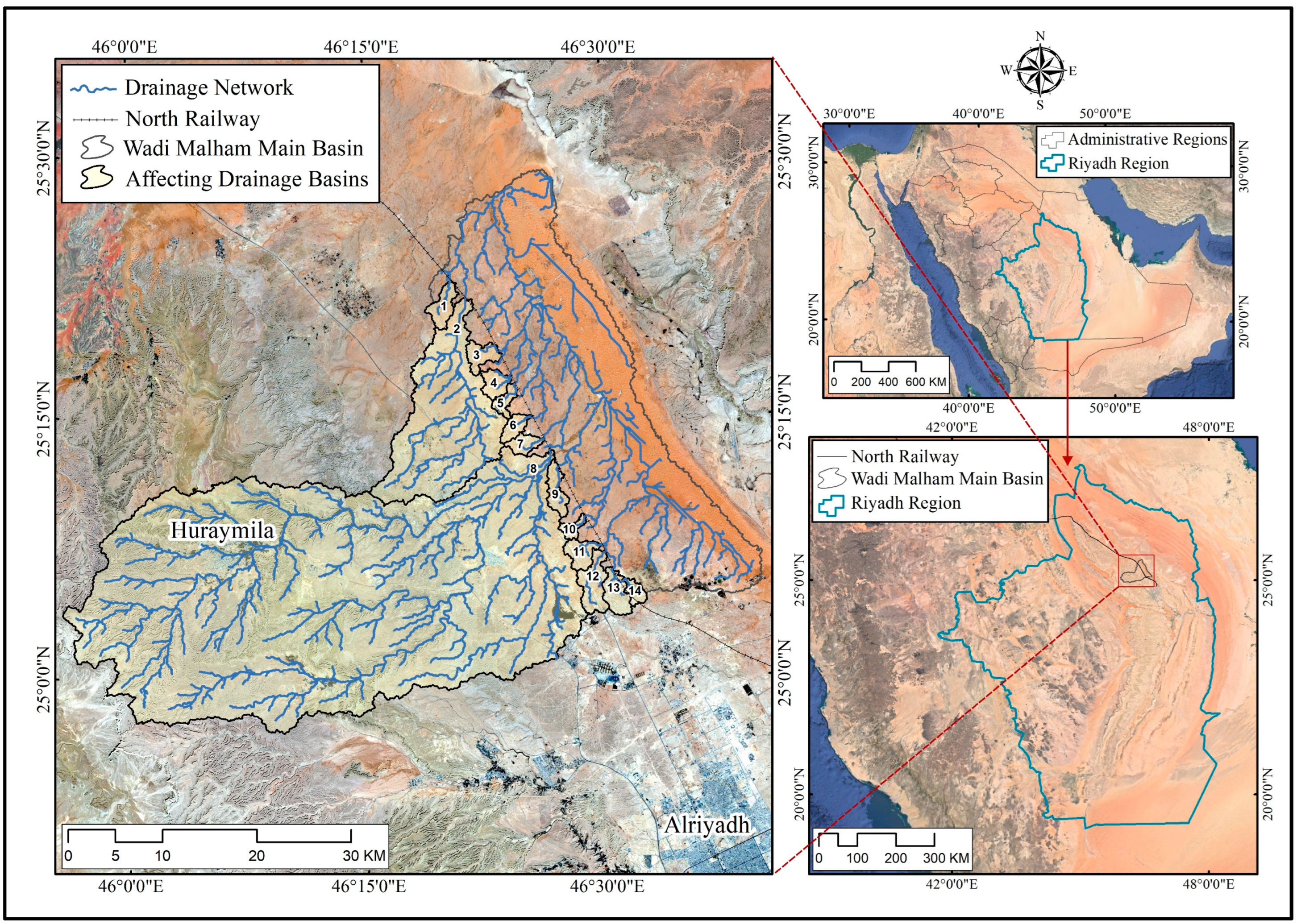
Figure 2.
Study Methodology.
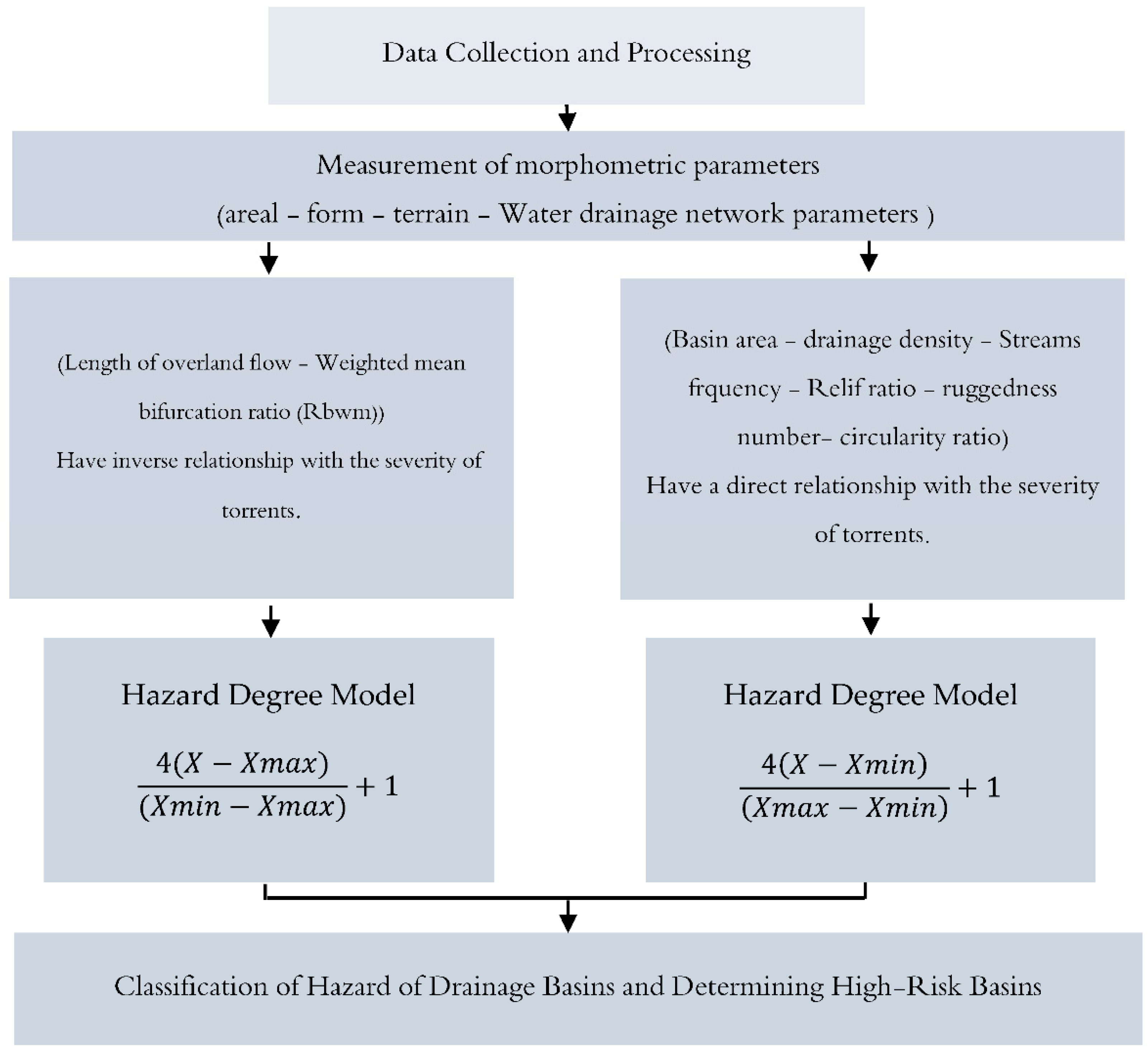
Figure 3.
DEM ALOS-PALSAR RTC for the study area Source: [40].
Figure 3.
DEM ALOS-PALSAR RTC for the study area Source: [40].
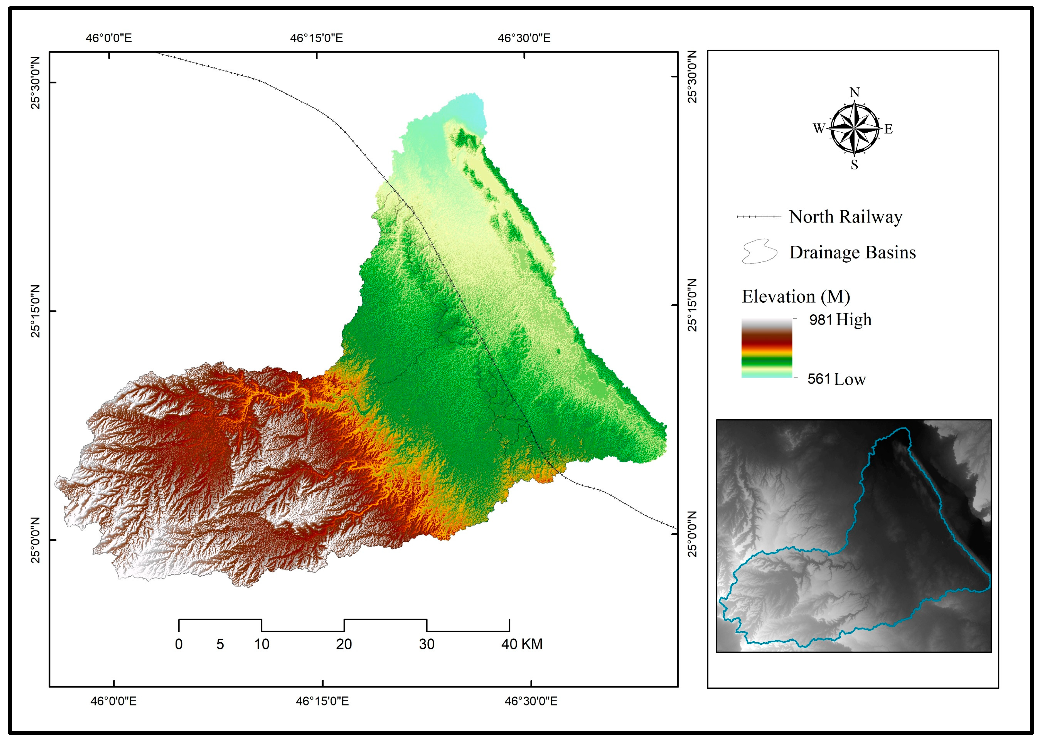
Figure 4.
Drainage basins and networks affecting the North Railway within the basin of Wadi Malham.
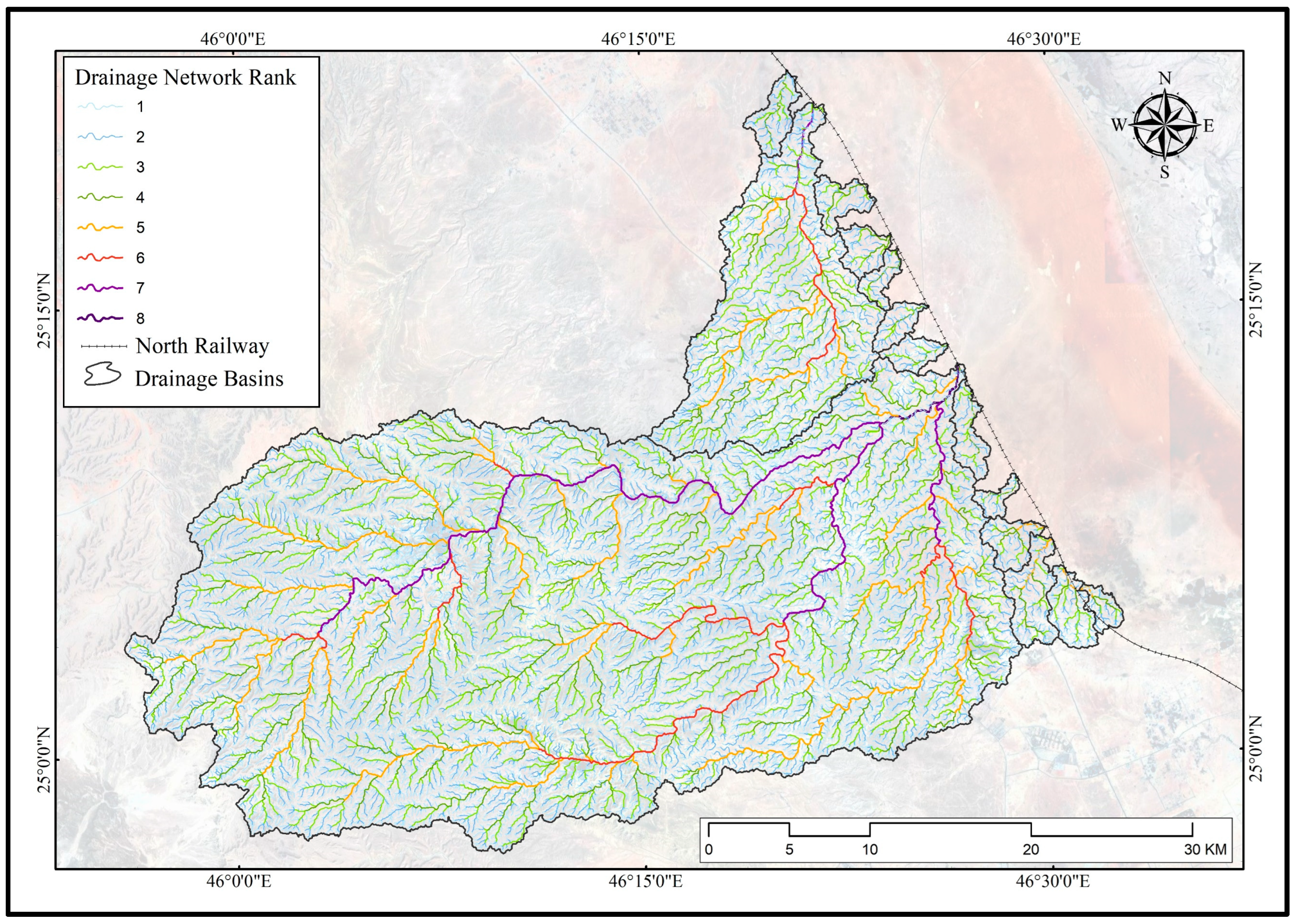
Figure 5.
Topographic maps, scale: 1:50000. Source: (Ministry of Petroleum and Mineral Resources, 1982).
Figure 5.
Topographic maps, scale: 1:50000. Source: (Ministry of Petroleum and Mineral Resources, 1982).
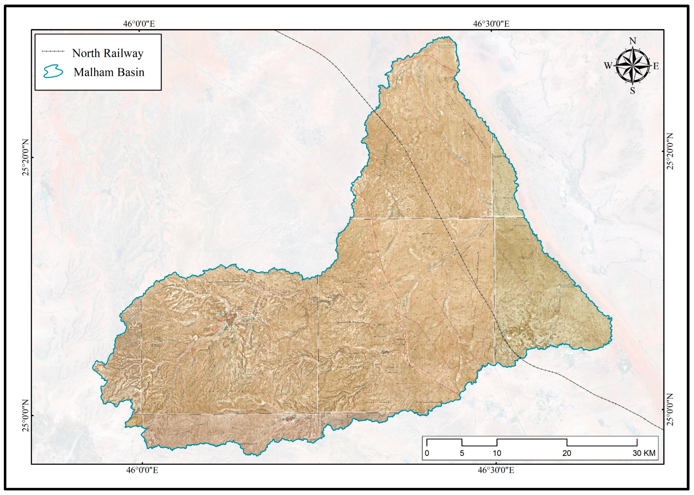
Figure 6.
Topographic maps, scale: 1:25000. Source: (General Commission for Survey, 2015).
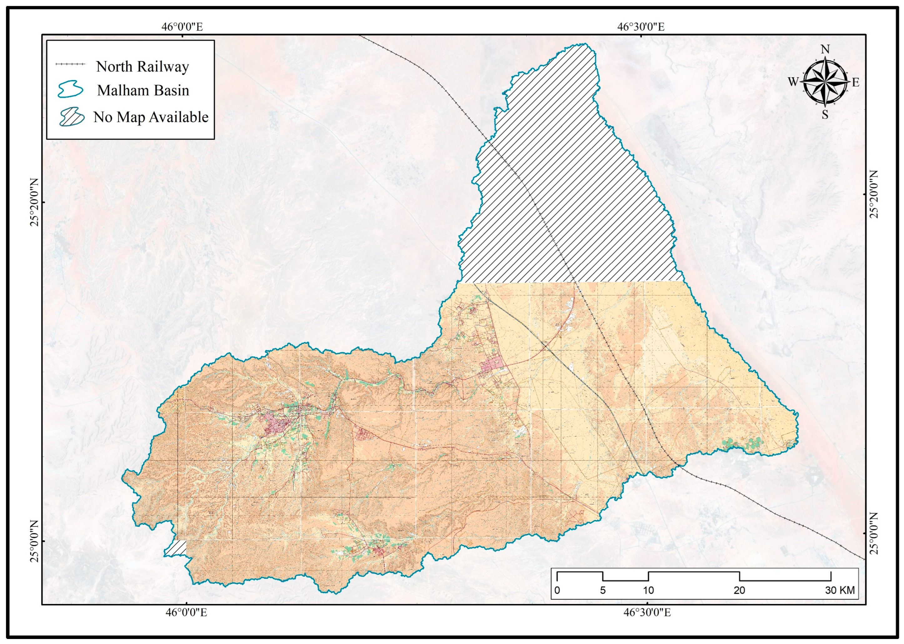
Figure 7.
Basin area.
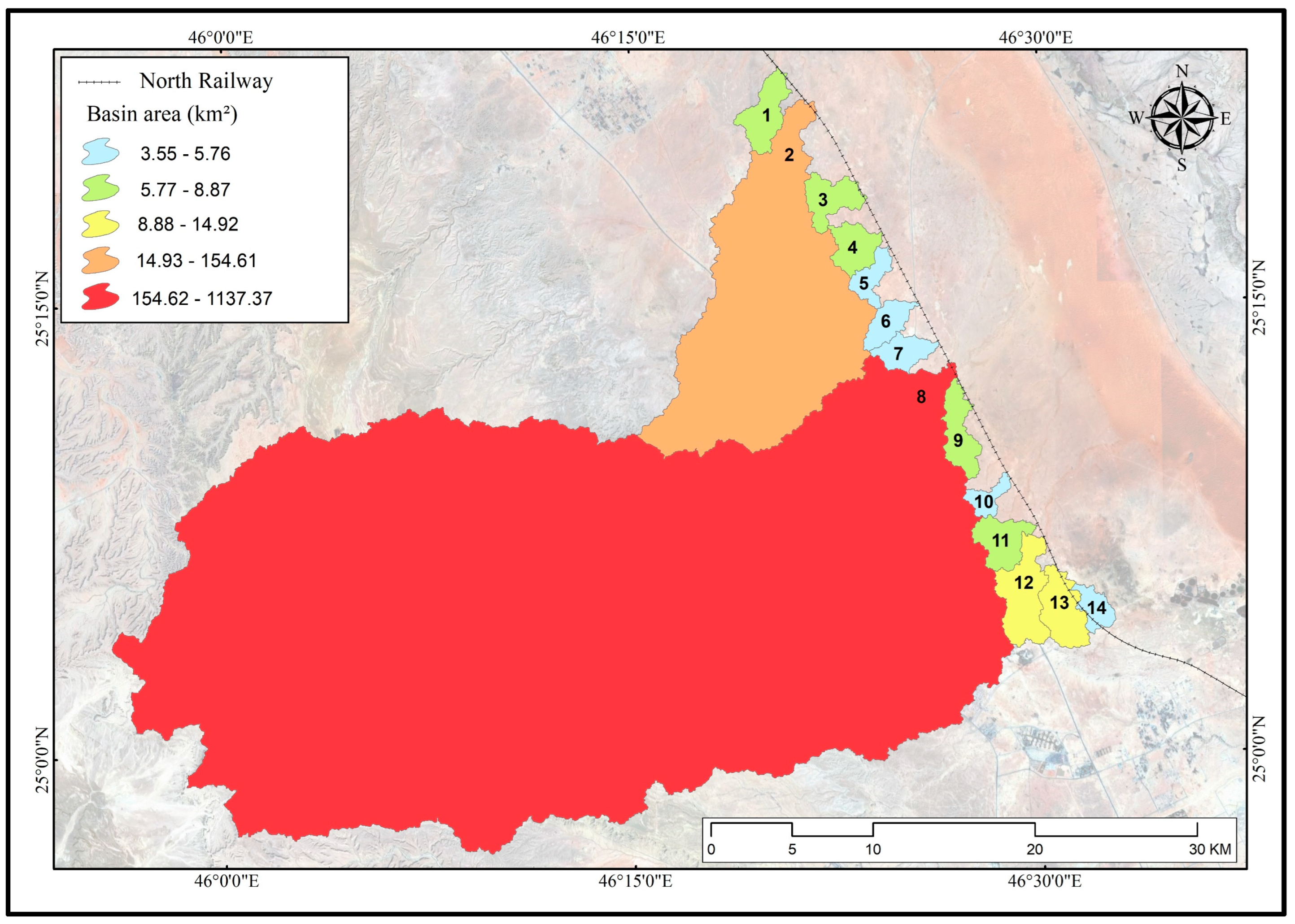
Figure 8.
Drainage density in basins.
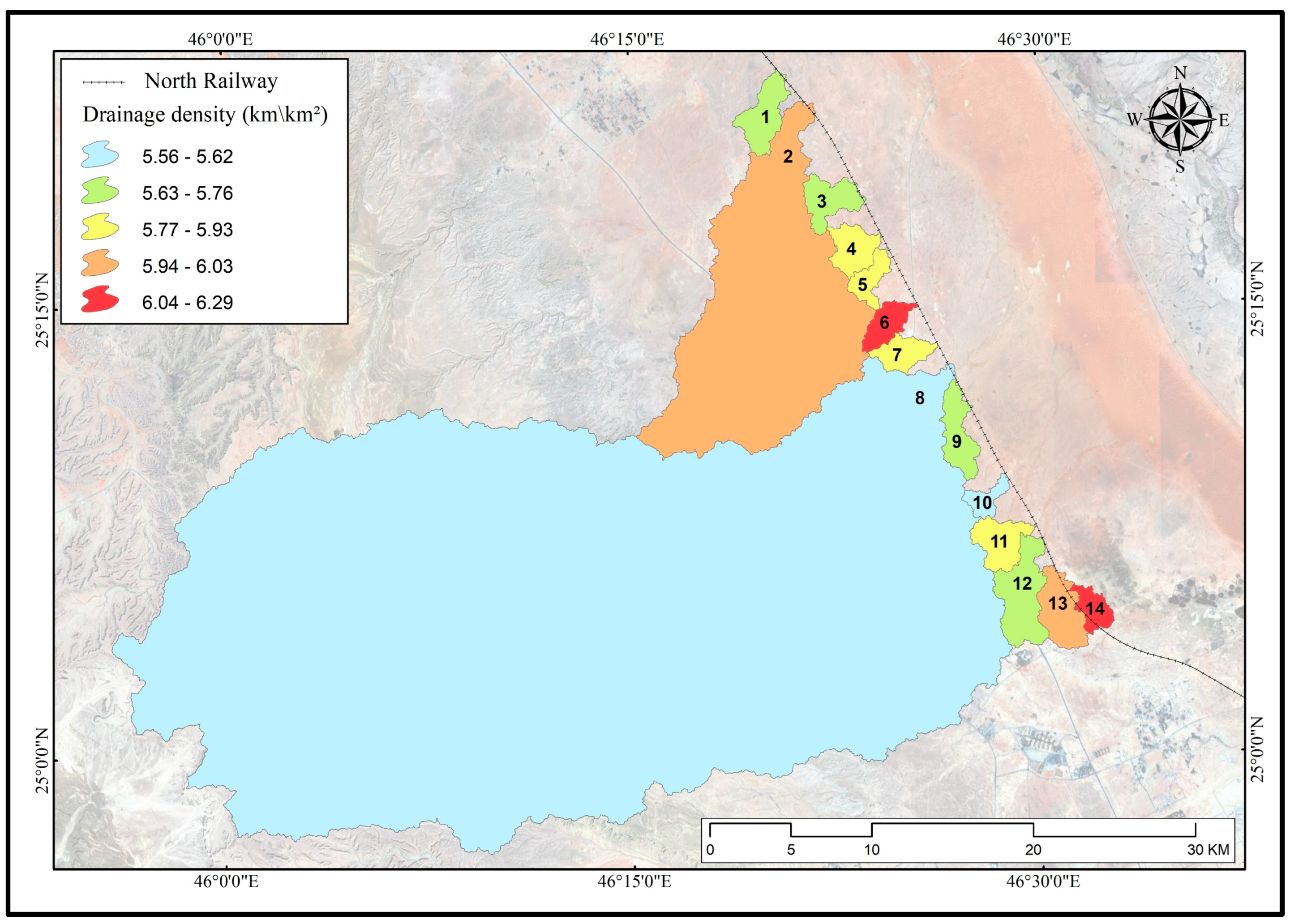
Figure 9.
Stream frequency in basins.
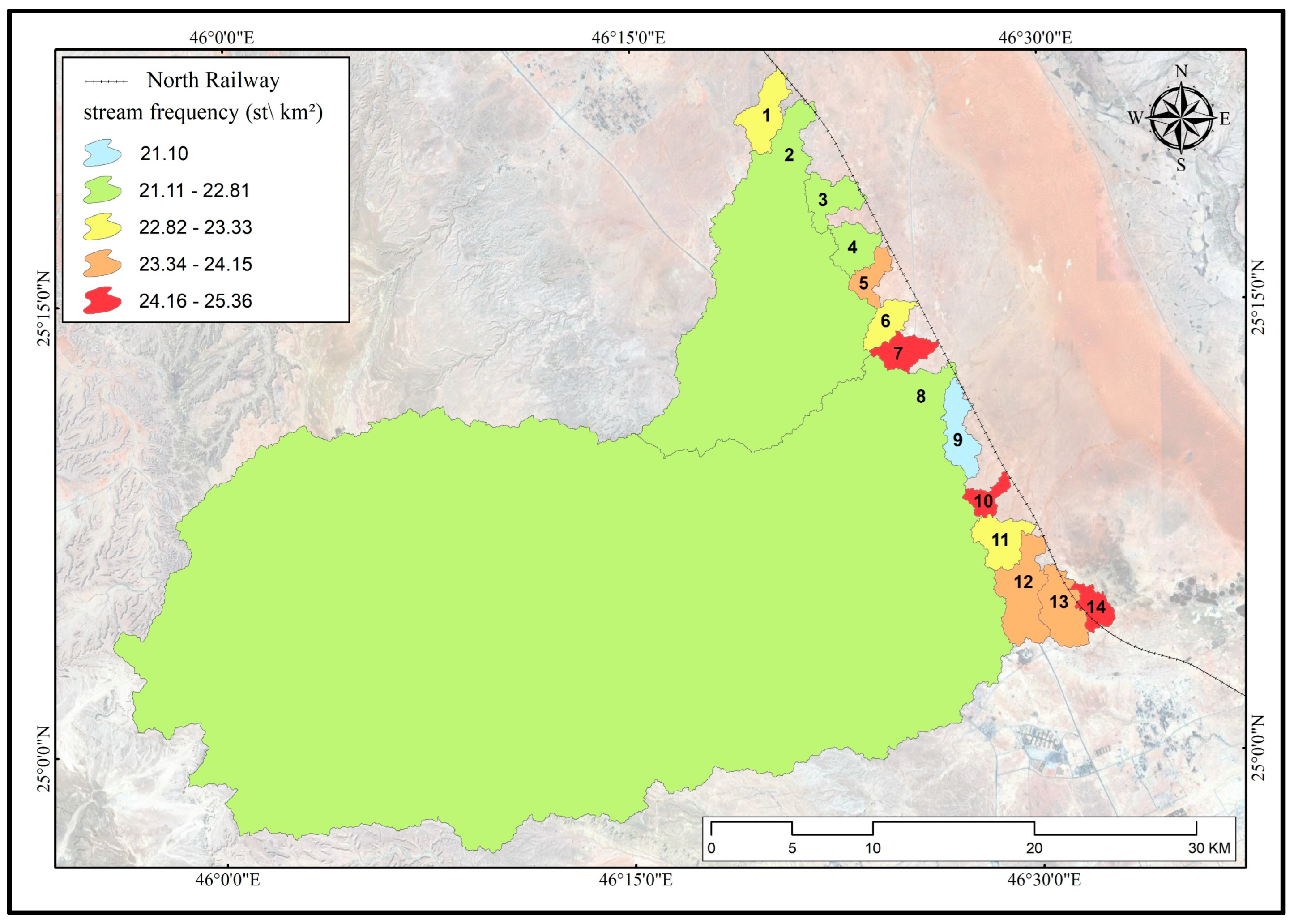
Figure 10.
Basin relief ratio.
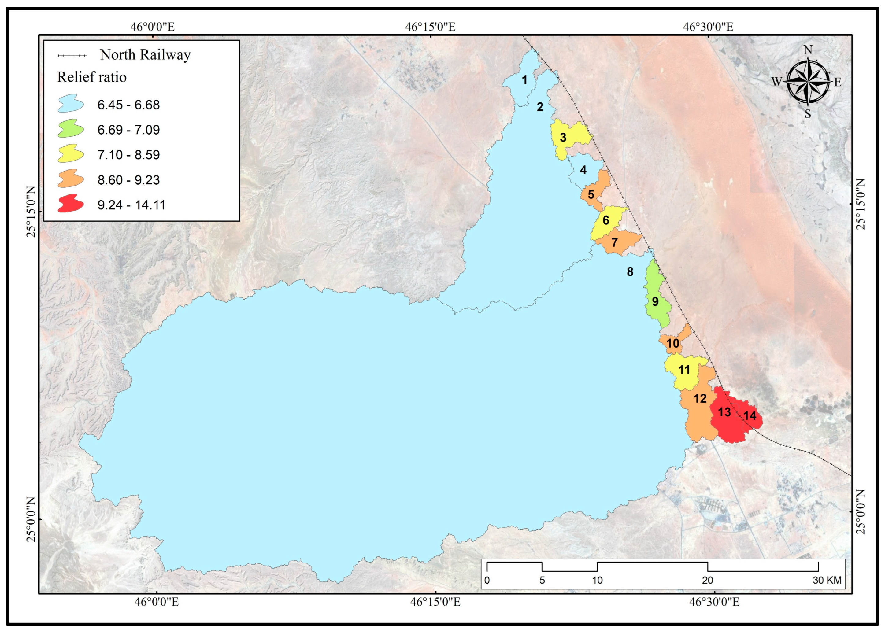
Figure 11.
ruggedness number of basins.

Figure 12.
Circularity ratio of basins.
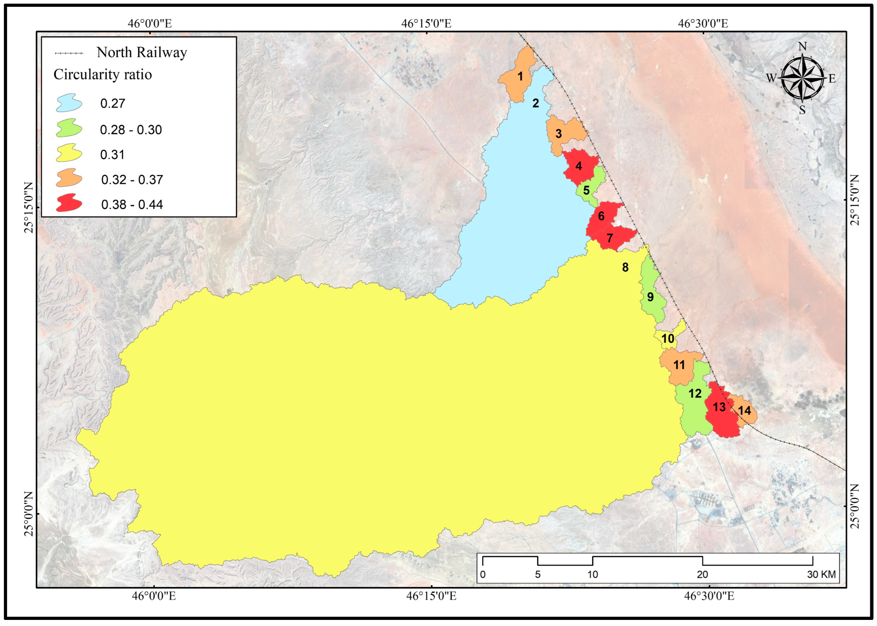
Figure 13.
Length of overland flow in basins.
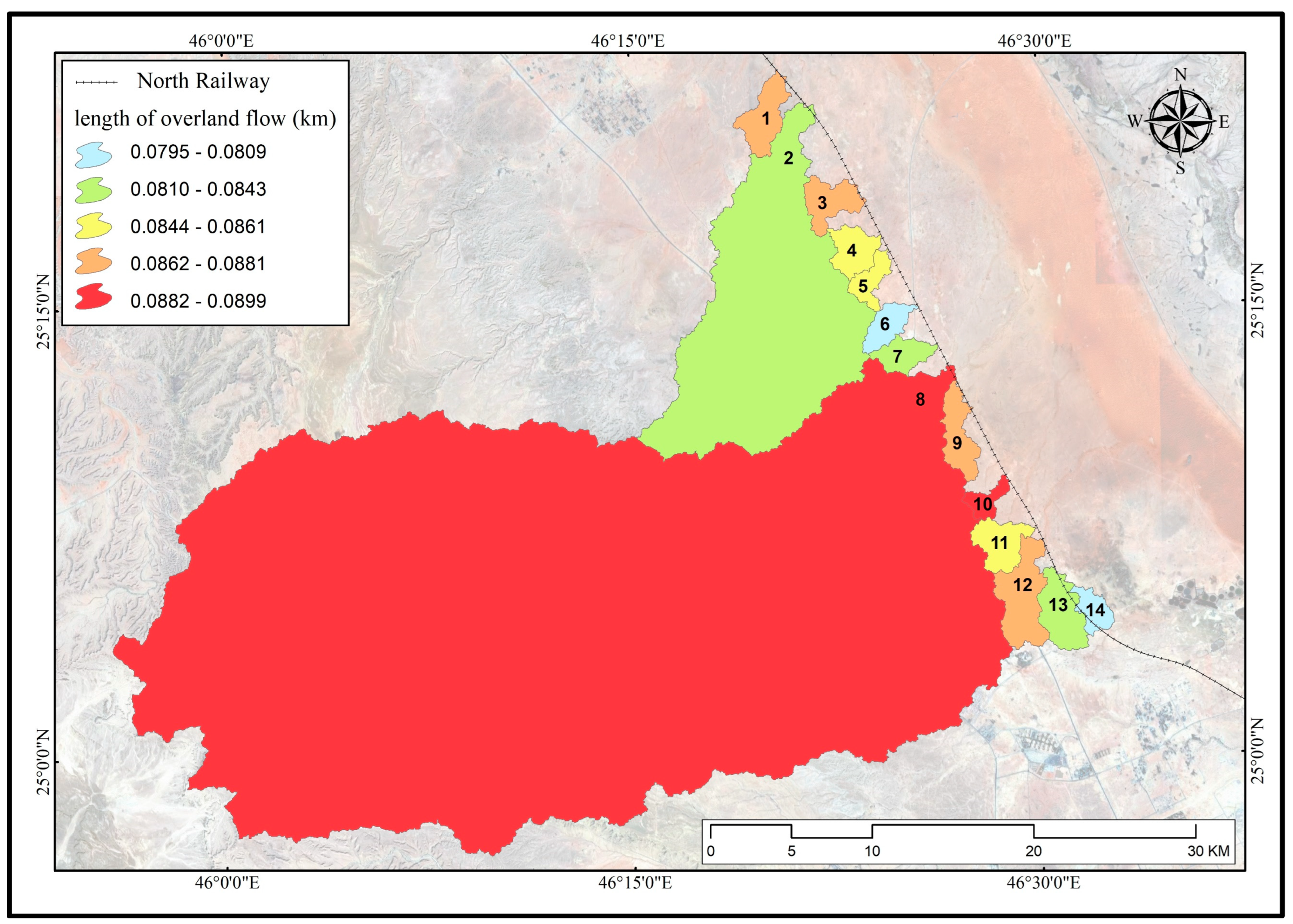
Figure 14.
Weighted mean bifurcation ratio in drainage basins.
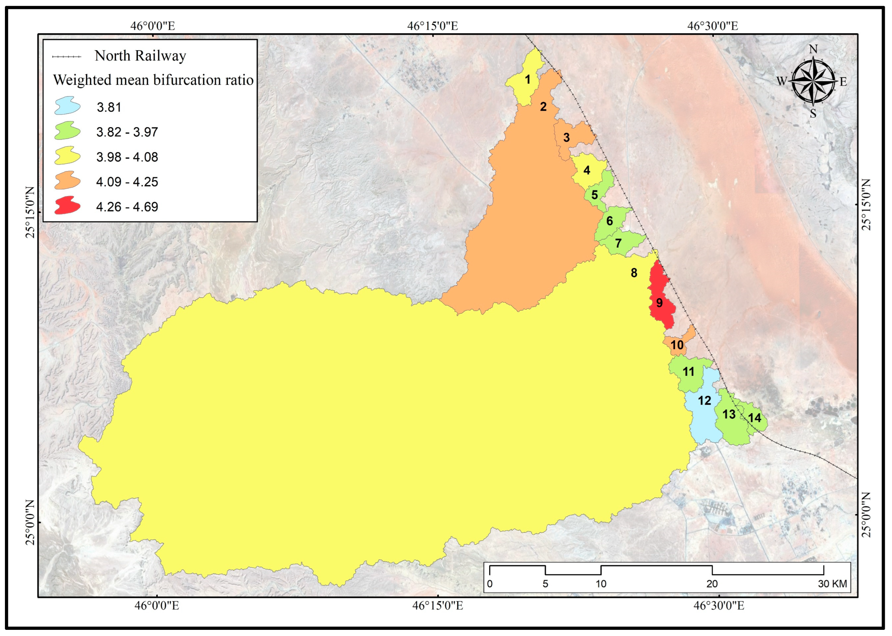
Figure 15.
Hazard degree of direct surface runoff in drainage basins in the study area.
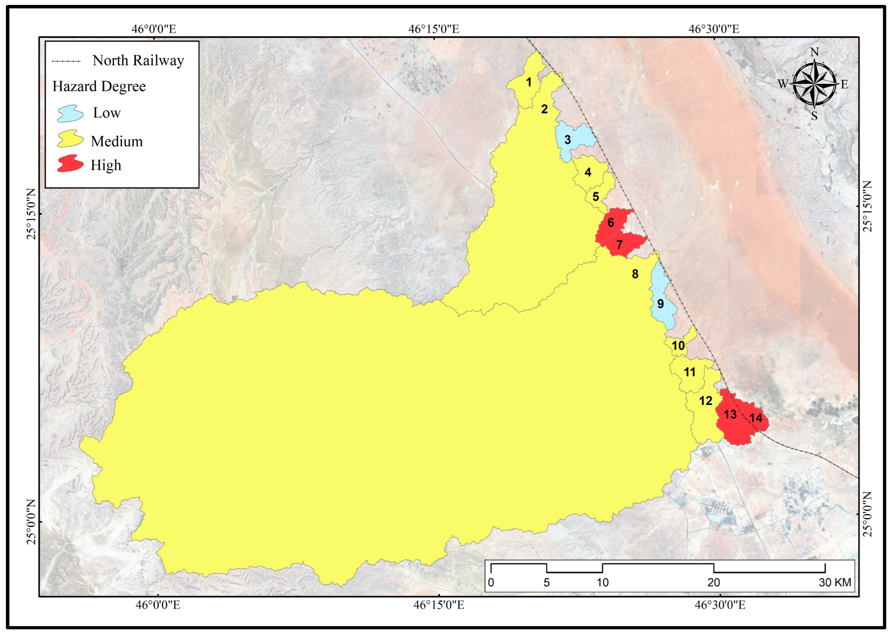
Table 1.
Morphometric parameters are used in applying the hazard degree model.
| Morphometric Measurement | Equation | Source of Equation |
|---|---|---|
| Basin area (A) | Measurement through ArcMap 10.7 | ([77]; documented in [17]) |
| Basin perimeter (P) | Measurement through ArcMap 10.7 | ([77]; documented in [17]) |
| Basin length () | Measurement through ArcMap 10.7 | ([77]; documented in [17]) |
| Stream order (u) | Hierarchical order | ([78] documented in [79]) |
| No. of streams (Nu) |
++…+ | ([80] documented in [79]) |
| Stream lengths () | Lu = + + ...+ | )[81] documented in [79]) |
| Drainage density () |
Lu = Total stream lengths for all orders, A= Basin area |
([80]; documented in [17]) |
| stream frequency () |
Nu = Total no. of streams for all orders, A = Basin area |
([80]; documented in [17]) |
| Basin relief () |
Maximum height = Minimum height = |
([82]; documented in [83]) |
| Relief ratio () |
Bh = Basin relief, = Basin length |
([84]; documented in [83]) |
| Ruggedness number () |
Bh = Basin relief, = drainage density |
([81]; documented in [81]) |
| Circularity ratio) ) |
A= Basin area, π= 3.1415, = Basin perimeter square |
([85]; documented in [17]) |
| length of overland flow () |
Dd = Drainage density |
([80]; documented in [17]) |
| Weighted mean bifurcation ratio |
Rb = bifurcation ratio (Nu/Nu+1), = Total number of drainage used in measuring the bifurcation ratio (Nu+(Nu+1)) |
([86]; documented in [75]) |
Table 2.
Morphometric parameters of drainage basins and networks in the study area.
| Parameters | Basin No | |||||||||||||
|---|---|---|---|---|---|---|---|---|---|---|---|---|---|---|
| 1 | 2 | 3 | 4 | 5 | 6 | 7 | 8 | 9 | 10 | 11 | 12 | 13 | 14 | |
| Basin area (Km2) | 8.87 | 154.61 | 7.74 | 7.10 | 4.78 | 5.57 | 5.76 | 1137.37 | 8.43 | 3.55 | 8.24 | 14.57 | 14.92 | 4.43 |
| Basin perimeter (Km) | 17.68 | 84.46 | 16.75 | 14.82 | 14.24 | 13.03 | 13.27 | 213.49 | 19.22 | 11.95 | 16.68 | 25.15 | 20.65 | 12.48 |
| Basin length (Km) | 5.39 | 23.62 | 3.73 | 3.60 | 3.90 | 4.42 | 4.32 | 55.36 | 5.50 | 3.20 | 4.21 | 6.83 | 5.10 | 3.40 |
| Steam order | 4 | 7 | 5 | 5 | 4 | 4 | 4. | 8 | 4 | 4 | 5 | 5 | 5 | 5 |
| No. of streams (stream) | 205 | 3521 | 174 | 162 | 114 | 130 | 143 | 25441 | 178 | 90 | 191 | 352 | 356 | 110 |
| Streams length (Km) | 51.15 | 928.05 | 44.26 | 41.86 | 27.78 | 34.42 | 34.19 | 6327.95 | 47.89 | 19.95 | 48.26 | 83.67 | 89.93 | 27.86 |
| Drainage density (Km2/ Km) | 5.76 | 6.00 | 5.72 | 5.90 | 5.81 | 6.18 | 5.93 | 5.56 | 5.68 | 5.62 | 5.86 | 5.74 | 6.03 | 6.29 |
| Streams frequency (Stream/Km2) | 23.10 | 22.77 | 22.48 | 22.81 | 23.85 | 23.33 | 24.81 | 22.37 | 21.10 | 25.36 | 23.17 | 24.15 | 23.86 | 24.85 |
| Highest point level (m) | 634 | 755 | 641 | 640 | 651 | 661 | 663 | 981 | 665 | 668 | 678 | 704 | 725 | 705 |
| Lowest point level (m) | 598 | 601 | 609 | 616 | 617 | 624 | 625 | 624 | 626 | 640 | 642 | 641 | 653 | 661 |
| Basin relief (m) | 36 | 154 | 32 | 24 | 34 | 37 | 38 | 357 | 39 | 28 | 36 | 63 | 72 | 44 |
| Relief ratio | 6.68 | 6.52 | 8.59 | 6.66 | 8.72 | 8.37 | 8.81 | 6.45 | 7.09 | 8.76 | 8.54 | 9.23 | 14.11 | 12.94 |
| Ruggedness number | 0.21 | 0.92 | 0.18 | 0.14 | 0.20 | 0.23 | 0.23 | 1.99 | 0.22 | 0.16 | 0.21 | 0.36 | 0.43 | 0.28 |
| Circularity ratio | 0.36 | 0.27 | 0.35 | 0.41 | 0.30 | 0.41 | 0.41 | 0.31 | 0.29 | 0.31 | 0.37 | 0.29 | 0.44 | 0.36 |
| Length of overland flow (Km) | 0.0867 | 0.0833 | 0.0875 | 0.0848 | 0.0861 | 0.0809 | 0.0843 | 0.0899 | 0.0881 | 0.0889 | 0.0854 | 0.0871 | 0.0829 | 0.0795 |
| Weighted mean bifurcation ratio | 4.00 | 4.16 | 4.25 | 4.05 | 3.97 | 3.93 | 3.92 | 4.08 | 4.69 | 4.24 | 3.92 | 3.81 | 3.97 | 3.91 |
Table 3.
Numbers and orders of streams in drainage basins.
| Basin No. | Order | Total | |||||||
|---|---|---|---|---|---|---|---|---|---|
| First | Second | Third | Fourth | Fifth | Sixth | Seventh | Eighth | ||
| 1 | 148 | 49 | 7 | 1 | - | - | - | - | 205 |
| 2 | 2674 | 652 | 150 | 35 | 7 | 2 | 1 | - | 3521 |
| 3 | 133 | 31 | 7 | 2 | 1 | - | - | - | 174 |
| 4 | 122 | 30 | 7 | 2 | 1 | - | - | - | 162 |
| 5 | 84 | 25 | 4 | 1 | - | - | - | - | 114 |
| 6 | 96 | 28 | 5 | 1 | - | - | - | - | 130 |
| 7 | 106 | 30 | 6 | 1 | - | - | - | - | 143 |
| 8 | 19173 | 4800 | 1194 | 209 | 52 | 9 | 3 | 1 | 25441 |
| 9 | 140 | 30 | 7 | 1 | - | - | - | - | 178 |
| 10 | 69 | 16 | 4 | 1 | - | - | - | - | 90 |
| 11 | 142 | 37 | 8 | 3 | 1 | - | - | - | 191 |
| 12 | 259 | 72 | 17 | 3 | 1 | - | - | - | 352 |
| 13 | 264 | 74 | 13 | 4 | 1 | - | - | - | 356 |
| 14 | 81 | 22 | 4 | 2 | 1 | - | - | - | 110 |
Disclaimer/Publisher’s Note: The statements, opinions and data contained in all publications are solely those of the individual author(s) and contributor(s) and not of MDPI and/or the editor(s). MDPI and/or the editor(s) disclaim responsibility for any injury to people or property resulting from any ideas, methods, instructions or products referred to in the content. |
© 2023 by the authors. Licensee MDPI, Basel, Switzerland. This article is an open access article distributed under the terms and conditions of the Creative Commons Attribution (CC BY) license (http://creativecommons.org/licenses/by/4.0/).
Copyright: This open access article is published under a Creative Commons CC BY 4.0 license, which permit the free download, distribution, and reuse, provided that the author and preprint are cited in any reuse.


