Submitted:
16 July 2023
Posted:
17 July 2023
You are already at the latest version
Abstract
Keywords:
1. Introduction
2. Data and Methods
3. Results and Discussion
3.1. Shear
3.2. Convective Available Potential Energy (CAPE)
3.3. Severe Thunderstorm Environment (STEnv)
3.4. Limitations
4. Conclusions
Author Contributions
Funding
Data Availability Statement
Acknowledgments
Conflicts of Interest
References
- Kron, W.; Löw, P.; Kundzewicz, Z.W. Changes in Risk of Extreme Weather Events in Europe. Environ. Sci. Policy 2019, 100, 74–83. [Google Scholar] [CrossRef]
- Raihan, M.L.; Onitsuka, K.; Basu, M.; Shimizu, N.; Hoshino, S. Rapid Emergence and Increasing Risks of Hailstorms: A Potential Threat to Sustainable Agriculture in Northern Bangladesh. Sustainability 2020, 12, 5011. [Google Scholar] [CrossRef]
- Rana, V.S.; Sharma, S.; Rana, N.; Sharma, U.; Patiyal, V.; Banita; Prasad, H. Management of hailstorms under a changing climate in agriculture: a review. Environmental Chemistry Letters 2022, 20(6), 3971–3991. [Google Scholar] [CrossRef]
- Božiček, A.; Franc, B.; Filipović-Grčić, B. Early Warning Weather Hazard System for Power System Control. Energies 2022, 15, 2085. [Google Scholar] [CrossRef]
- Al-Fugara, A.; Mabdeh, A.N.; Alayyash, S.; Khasawneh, A. Hydrological and Hydrodynamic Modeling for Flash Flood and Embankment Dam Break Scenario: Hazard Mapping of Extreme Storm Events. Sustainability 2023, 15, 1758. [Google Scholar] [CrossRef]
- Krvavica, N.; Rubinić, J. Evaluation of Design Storms and Critical Rainfall Durations for Flood Prediction in Partially Urbanized Catchments. Water 2020, 12, 2044. [Google Scholar] [CrossRef]
- Breugem, A.J.; Wesseling, J.G.; Oostindie, K.; Ritsema, C.J. Meteorological Aspects of Heavy Precipitation in Relation to Floods – An Overview. Earth-Sci. Rev. 2020, 204, 103171. [Google Scholar] [CrossRef]
- Mehedi, M.A.A.; Yazdan, M.M.S.; Ahad, M.T.; Akatu, W.; Kumar, R.; Rahman, A. Quantifying Small-Scale Hyporheic Streamlines and Resident Time under Gravel-Sand Streambed Using a Coupled HEC-RAS and MIN3P Model. Eng 2022, 3, 276–300. [Google Scholar] [CrossRef]
- Mehedi, M.A.A.; Yazdan, M.M.S. Automated Particle Tracing & Sensitivity Analysis for Residence Time in a Saturated Subsurface Media. Liquids 2022, 2(3), 72–84. [Google Scholar]
- Raihan, M.L.; Onitsuka, K.; Basu, M.; Shimizu, N.; Hoshino, S. Rapid emergence and increasing risks of hailstorms: A potential threat to sustainable agriculture in Northern Bangladesh. Sustainability 2020, 12(12), 5011. [Google Scholar] [CrossRef]
- Pan, C.; Wang, X.; Liu, L.; Huang, H.; Wang, D. Improvement to the Huff Curve for Design Storms and Urban Flooding Simulations in Guangzhou, China. Water 2017, 9, 411. [Google Scholar] [CrossRef]
- Yazdan, M.M.S.; Ahad, M.T.; Kumar, R.; Mehedi, M.A.A. Estimating Flooding at River Spree Floodplain Using HEC-RAS Simulation. J 2022, 5, 410–426. [Google Scholar] [CrossRef]
- Vorobevskii, I.; Al Janabi, F.; Schneebeck, F.; Bellera, J.; Krebs, P. Urban Floods: Linking the Overloading of a Storm Water Sewer System to Precipitation Parameters. Hydrology 2020, 7, 35. [Google Scholar] [CrossRef]
- The Guardian, 2011. Killer StormStorm at Belgium's Pukkelpop music festival kills five after stage collapses. Link: https://www.theguardian.com/world/2011/aug/18/pukkelpop-belgium-festival-killerstorm.
- Alimonti, G.; Mariani, L.; Prodi, F.; Ricci, R.A. A Critical Assessment of Extreme Events Trends in Times of Global Warming. Eur. Phys. J. Plus 2022, 137, 112. [Google Scholar] [CrossRef]
- Aryee, J.N.A.; Ahiataku, M.A.; Quagraine, K.T.; Davies, P.; Agbenor-Efunam, N.; Agyapong, G.; Agyekum, J.; Donkor, M.K.E.; Osei, M.A.; Poku, L.P.; et al. C: High-Impact Weather (HIW) Forecasting In Ghana: Challenges And Prospects Of The Nowcasting Satellite Facility (NWCSAF) For Improved Early Warning And Decision-Making; Preprints, 2022.
- Jiang, Z.; Johnson, F. A New Method for Postprocessing Numerical Weather Predictions Using Quantile Mapping in the Frequency Domain. Mon. Weather Rev. 2023, 1. [Google Scholar] [CrossRef]
- Das, S. Challenges in Predicting Extreme Weather Events Over the South Asian Region. In Extreme Natural Events: Sustainable Solutions for Developing Countries; Unnikrishnan, A.S., Tangang, F., Durrheim, R.J., Eds.; Springer Nature: Singapore, 2022; pp. 51–106. ISBN 978-981-19251-1-5. [Google Scholar]
- Kumari, S.; Mahalakshmi, P. A Wide Scale Survey on Weather Prediction Using Machine Learning Techniques, 2022, Journal of Information and Knowledge Management. [CrossRef]
- Azadi, H.; Barati, A.A.; Nazari Nooghabi, S.; Scheffran, J. Climate-Related Disasters and Agricultural Land Conversion: Towards Prevention Policies. Clim. Dev. 2022, 14, 814–828. [Google Scholar] [CrossRef]
- Johns, R.H.; Doswell, C.A. Severe Local Storms Forecasting. Weather Forecast. 1992, 7, 588–612. [Google Scholar] [CrossRef]
- Mehedi, M.A.A.; Khosravi, M.; Yazdan, M.M.S.; Shabanian, H. Exploring Temporal Dynamics of River Discharge Using Univariate Long Short-Term Memory (LSTM) Recurrent Neural Network at East Branch of Delaware River. Hydrology 2022, 9, 202. [Google Scholar] [CrossRef]
- Ahmad, M.; Al Mehedi, M.A.; Yazdan, M.M.S.; Kumar, R. Development of Machine Learning Flood Model Using Artificial Neural Network (ANN) at Var River. Liquids 2022, 2, 147–160. [Google Scholar] [CrossRef]
- Yazdan, M. M. S. , Khosravia, M., Saki, S., & Al Mehedi, M. A. Forecasting Energy Consumption Time Series Using Recurrent Neural Network in Tensorflow, 2022. link: Forecasting Energy Consumption Time Series Using Recurrent Neural Network in Tensorflow. Preprints. 2022, 2022090404. [CrossRef]
- Khosravi, M.; Ghoochani, S.; Nazemi, N. Deep Learning-Based Modeling of Daily Suspended Sediment Concentration and Discharge in Esopus Creek 2023.
- Khosravi, M.; Duti, B.M.; Yazdan, M.M.S.; Ghoochani, S.; Nazemi, N.; Shabanian, H. Simultaneous Prediction of Stream-Water Variables Using Multivariate Multi-Step Long Short-Term Memory Neural Network. Preprints.org 2023, 2023020086. [Google Scholar] [CrossRef]
- Khosravi, M.; Mehedi, M.A.A.; Baghalian, S.; Burns, M.; Welker, A.L.; Golub, M. Using Machine Learning to Improve Performance of a Low-Cost Real-Time Stormwater Control Measure. Preprints 2022, 2022110519. [Google Scholar] [CrossRef]
- Khosravi, M.; Ghoochani, S.; Nazemi, N. Deep Learning-Based Modeling of Daily Suspended Sediment Concentration and Discharge in Esopus Creek. Preprints. 2023, 2023051167. [Google Scholar] [CrossRef]
- Khosravi, M.; Tabasi, S.; Hossam Eldien, H.; Motahari, M.R.; Alizadeh, S.M. Evaluation and Prediction of the Rock Static and Dynamic Parameters. J. Appl. Geophys. 2022, 199, 104581. [Google Scholar] [CrossRef]
- Mehedi, M.A.A., Reichert, N., & Molkenthin, F. (2020, May). Sensitivity Analysis of Hyporheic Exchange to Small Scale Changes in Gravel-Sand Flumebed Using a Coupled Groundwater-Surface Water Model. In EGU General Assembly Conference Abstracts (p. 20319).
- Stull, R. B.; An Introduction to Boundary Layer Meteorology. 1988, Springer Book series: Atmospheric and Oceanographic Sciences Library. [CrossRef]
- Stull, R.B. Practical Meteorology: An Algebra based Survey of Atmospheric Science. 2017. -version 1.02b. Univ. of British Columbia. 940 pages. ISBN: 978-0-88865-283-6.
- Nugent, A.; DeCou, D.; Russell, S.; and Karamperidou, C. Atmospheric Science, 2019. Open text book for Course Atmo 200, Atmospheric Processes and Phenomenon at the University of Hawai’i at Mānoa link: Atmospheric Processes and Phenomena – Open Textbook (hawaii.edu).
- Brooks, H.E. Proximity Soundings for Severe Convection for Europe and the United States from Reanalysis Data. Atmospheric Res. 2009, 93, 546–553. [Google Scholar] [CrossRef]
- Stull, R.B. Course Material: Atmospheric Science 201, 2002, Department of Earth, Ocean and Atmospheric Sciences, University of British Columbia, Vancouver, Canada. Link: UBC ATSC 201 - Atmospheric Soundings & Stability - Tutorial A.
- AWS- Air Weather Service; The Use of Skew T-Log P diagram in analysis and forecasting, Technical Report- 79/006, 1990, Scott Airforce Base, Illinois, 62225-5008. Link: SkewTDocumentation.pdf (arizona.edu).
- Taszarek, M.; Brooks, H.E.; Czernecki, B. Sounding-Derived Parameters Associated with Convective Hazards in Europe. Mon. Weather Rev. 2017, 145, 1511–1528. [Google Scholar] [CrossRef]
- Lin, Y.; Kumjian, M.R. Influences of CAPE on Hail Production in Simulated Supercell Storms, Journal of Atmospheric Sciences, American Meteorological Society, 2022, volume 79, issue 1, 179-204. [CrossRef]
- Peters, J.M.; Nowotarski, C.J.; Morrison, H. The Role of Vertical Wind Shear in Modulating Maximum Supercell Updraft Velocities, Journal of Atmospheric Sciences, American Meteorological Society, 2019, volume 76, issue 10, 3169. [CrossRef]
- Púčik; Groenemeijer, P.; Rýva, D.; Kolář, M. Proximity Soundings of Severe and Nonsevere Thunderstorms in Central Europe. Mon. Weather Rev. 2015, 143, 4805–4821. [Google Scholar] [CrossRef]
- Kunkel, E.; Karl, R.; Brooks, H.; Kossin, J.; Lawrimore, H.; Arndt, D.; Bosart, L.; Changnon, D.; Cutter, L.; Doesken, N.; et al. Monitoring and Understanding Trends in Extreme Storms: State of Knowledge. Bull. Am. Meteorol. Soc. 2013, 499–514. [Google Scholar] [CrossRef]
- Sobel, A.H.; Camargo, S.J. Projected Future Seasonal Changes in Tropical Summer Climate. 2011; 24, 473–487. [Google Scholar] [CrossRef]
- Seeley, J.T.; Romps, D.M. The Effect of Global Warming on Severe Thunderstorms in the United States. J. Clim. 2015, 28, 2443–2458. [Google Scholar] [CrossRef]
- Azad, M.A.K.; Islam, A.R.M.T.; Rahman, M.S.; Ayen, K. Development of novel hybrid machine learning models for monthly thunderstorm frequency prediction over Bangladesh. Natural Hazards 2021, 108, 1109–1135. [Google Scholar] [CrossRef]
- Wahiduzzaman, M.; Islam, A.R.M.T.; Luo, J.; Shahid, S.; Uddin, M.J.; Shimul, S.M.; Sattar, M.A. Trends and Variabilities of Thunderstorm Days over Bangladesh on the ENSO and IOD Timescales. Atmosphere 2020, 11, 1176. [Google Scholar] [CrossRef]
- Diffenbaugh, N.S.; Scherer, M.; Trapp, R.J. Robust Increases in Severe Thunderstorm Environments in Response to Greenhouse Forcing. Proc. Natl. Acad. Sci. 2013, 110, 16361–16366. [Google Scholar] [CrossRef] [PubMed]
- Trapp, R.J.; Diffenbaugh, N.S.; Gluhovsky, A. Transient Response of Severe Thunderstorm Forcing to Elevated Greenhouse Gas Concentrations. Geophys. Res. Lett. 2009, 36. [Google Scholar] [CrossRef]
- Duti, B.M. , Alam R.Q., Hossain M. M. Changing Climate and Surface & GroundWater Related Issues in Dhaka”, Journal of Engineering Science (JES) 2012, ISSN: 2075-4914, Published by the Faculty of Civil Engineering,Khulna University of Engineering and Technology (KUET), Bangladesh.
- Duti B.M., Willems P. Impact of Climate Change on Water Availability and Extreme flows of Jamuneshwari River Basin in Bangladesh, International Conference on Research into Action in Bangladesh, Gobeshona6, 20-24 January 2020, organized by International Centre for Climate Change and Development (ICCCAD).
- Belayneh, A.; Duti, B.M.; Mekuanent, F.; Biniyam, S.; Gebrehiwot, T.; Buruk, W. Effect of Different HRU Definition on Catchment Runoff Prediction and Climate Change Impact Investigation Using the SWAT Model in the Kleine Nete Basin, Belgium. 3rd Open Water symposium 2015, Addis Ababa, Ethiopia. [Google Scholar]
- Duti, B.M.; Khan, M.F.A.; Tamanna, T.; Mukherjee, N.; Rashid, M.A. Vulnerability Assessment and Adaptation Technique for Climate Change Induced Drought in Bangladesh. 5th International Conference on Water & Flood Management, ICWFM- 2015, Organized by Institute of Water and Flood Management (IWFM), Bangladesh University of Engineering and Technology, Dhaka-1000, Bangladesh.
- Aktar, M.N.; Ahmed, F.; Duti, B.M.; Khan, M.F.A.; Saniruzzaman; Akand, M.K. Assessing WATSAN Vulnerability due to Climate Change in Bangladesh and Formulating Adaptation Strategies. 5th International Conference on Water & Flood Management ICWFM 2015, Dhaka-1000, Bangladesh.
- Alam ,R.Q.; Duti , B.M.; Monowar, M.M. Climate Change Impacts on Water Related Sectors of Dhaka City and Assessing the Plausible Adaptation Options Proceedings of the 2nd International Conference on Environmental Technology & Construction Engineering for Sustainable Development ICETCESD 2012, Shahjalal University of Science and Technology, Sylhet, Bangladesh.
- Duti, B.M.; Aurin, F.H.; Rahman, M.D.M. Changes Observed in The Historical Trend Of Local Rainfall As A Climatic Factor And Its Effect On The Streamflow Of The Turag And Buriganga River System, 1st International Conference on Environmental Technology & Construction Engineering for Sustainable Development ICETCESD 2011, Shahjalal University of Science and Technology, Sylhet, Bangladesh.
- Intergovernmental Panel on Climate Change (IPCC). Managing the Risks of Extreme Events and Disasters to Advance Climate Change Adaptation. A Special Report of Working Groups I and II of the Intergovernmental Panel on Climate Change [Field, C.B., V. Barros, T.F. Stocker, D. Qin, D.J. Dokken, K.L. Ebi, M.D. Mastrandrea, K.J. Mach, G.-K. Plattner, S.K. Allen, M. Tignor, and P.M. Midgley (eds.)] 2012, Cambridge University Press, Cambridge, UK, and New York, NY, USA, 582 pp.
- Intergovernmental Panel on Climate Change (IPCC). Climate Change: The Physical Science Basis: Working Group I Contribution to the Fifth Assessment Report 2013; Cambridge University Press: Cambridge, 2014; ISBN 978-1-107-05799-9. [Google Scholar]
- Georgi, F.; Jones, C.; Asrar, G. Addressing Climate Information Needs at the Regional Level: The CORDEX Framework. WMO Bull 2008, 53. [Google Scholar]
- Seneviratne, S.I.; Nicholls, N.; Easterling, D.; Goodess, C.M.; Kanae, S.; Kossin, J.; Luo, Y.; J. Marengo, J.; McInnes, K.; Rahimi, M.; Reichstein, M.; Sorteberg, A.; Vera, C.; Zhang, X. Changes in climate extremes and their impacts on the natural physical environment. In: Managing the Risks of Extreme Events and Disasters to Advance Climate Change Adaptation [Field, C.B., V. Barros, T.F. Stocker, D. Qin, D.J. Dokken, K.L. Ebi, M.D. Mastrandrea, K.J. Mach, G.-K. Plattner, S.K. Allen, M. Tignor, and P.M. Midgley (eds.)]. A Special Report of Working Groups I and II of the Intergovernmental Panel on Climate Change (IPCC). 2012. Cambridge University Press, Cambridge, UK, and New York, NY, USA, pp. 109-230.
- Lepore, C.; Abernathey, R.; Henderson, N.; Allen, J.T.; Tippett, M.K. Future Global Convective Environments in CMIP6 Models, Earth’s Future, volume 9, issue 12, AGU (American Geological Union), 2021. [CrossRef]
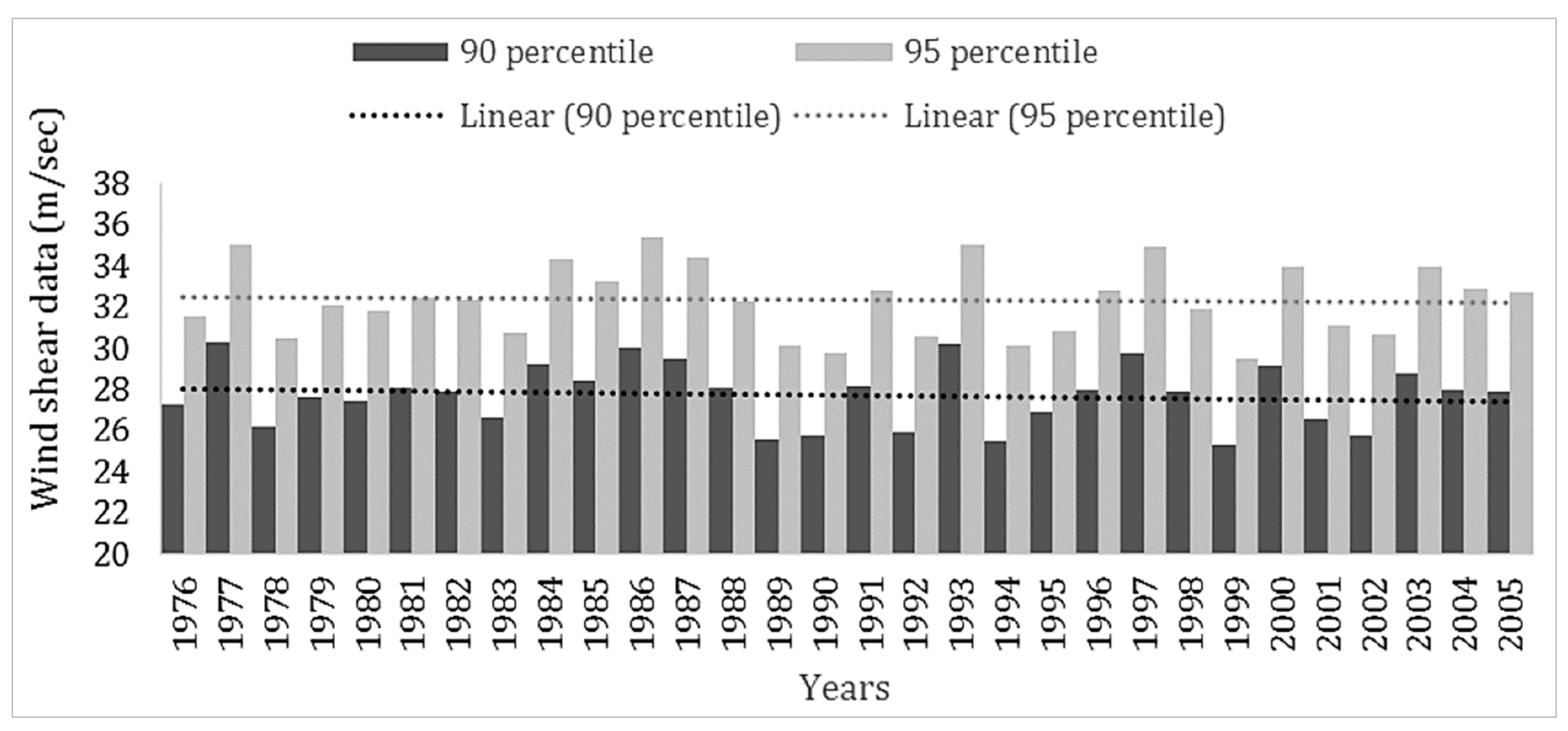
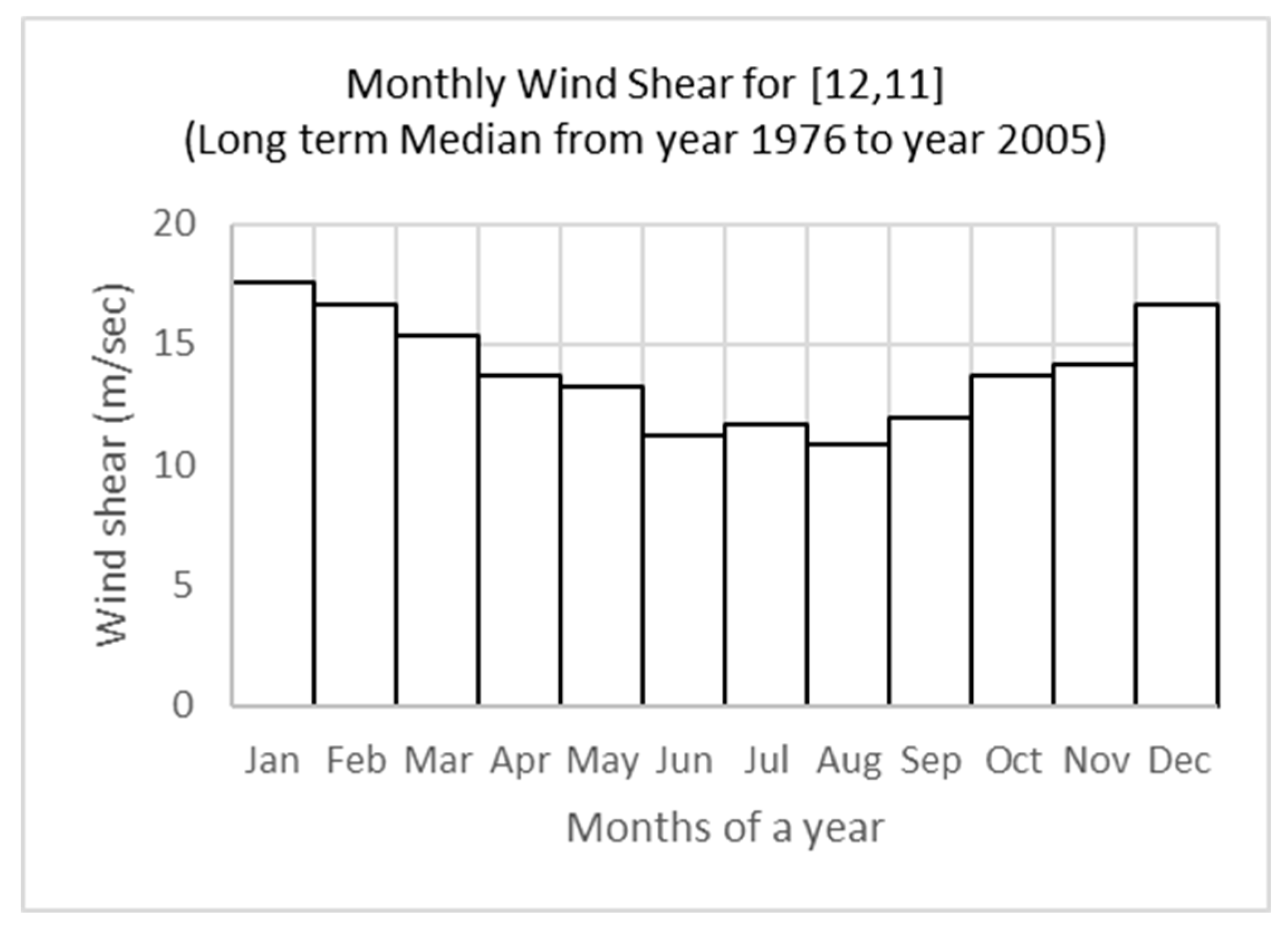
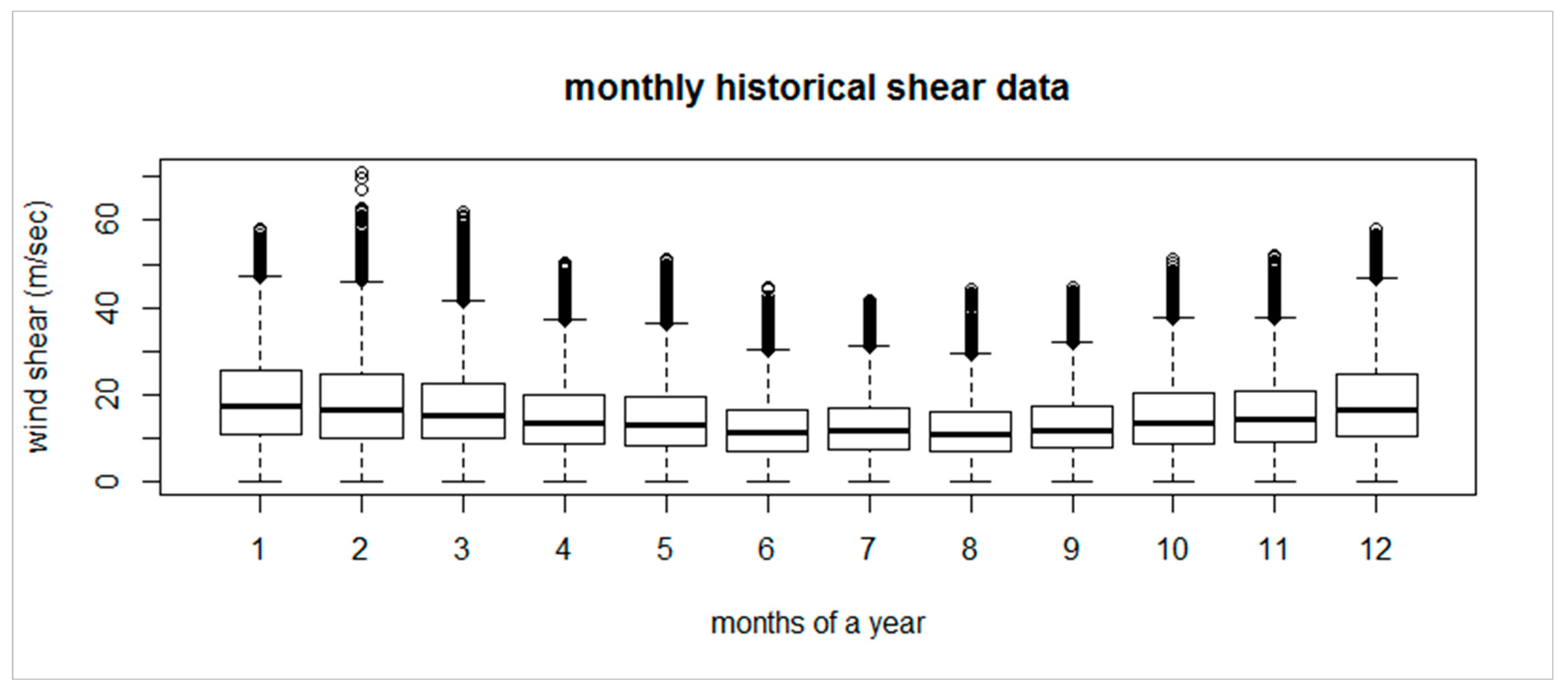
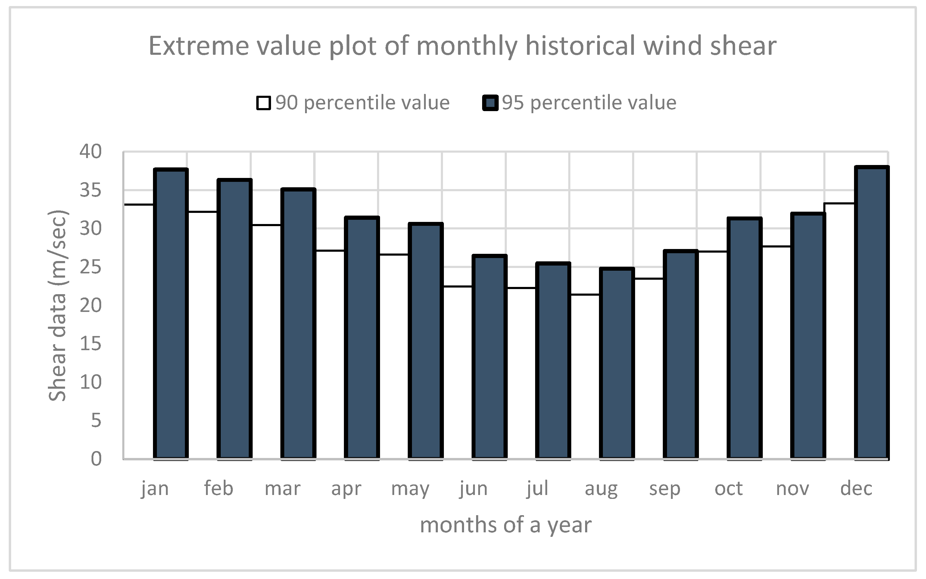
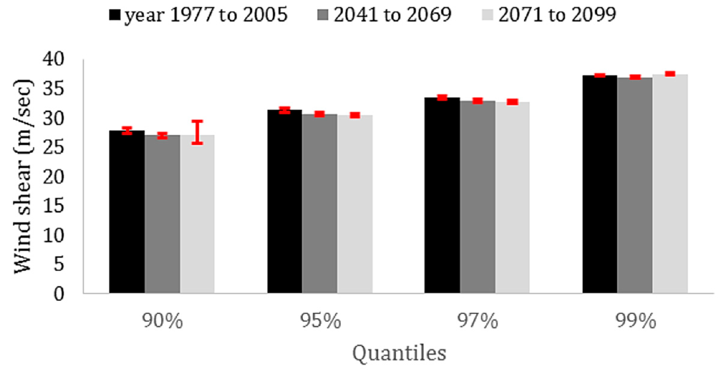
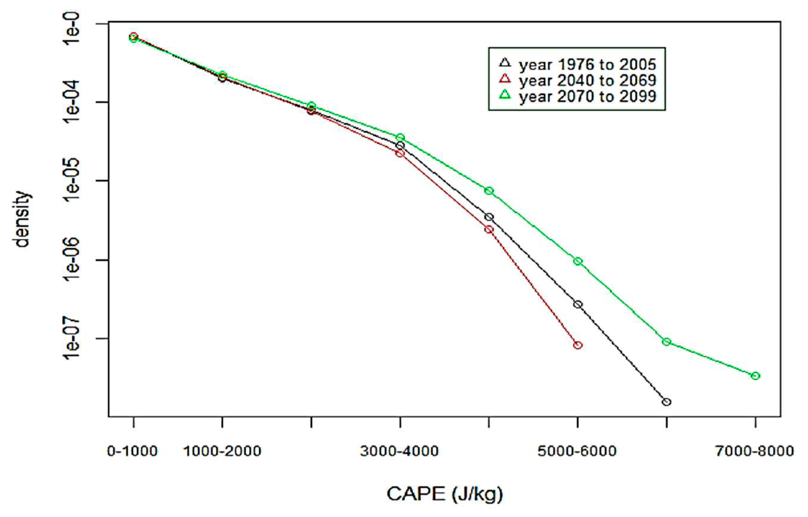
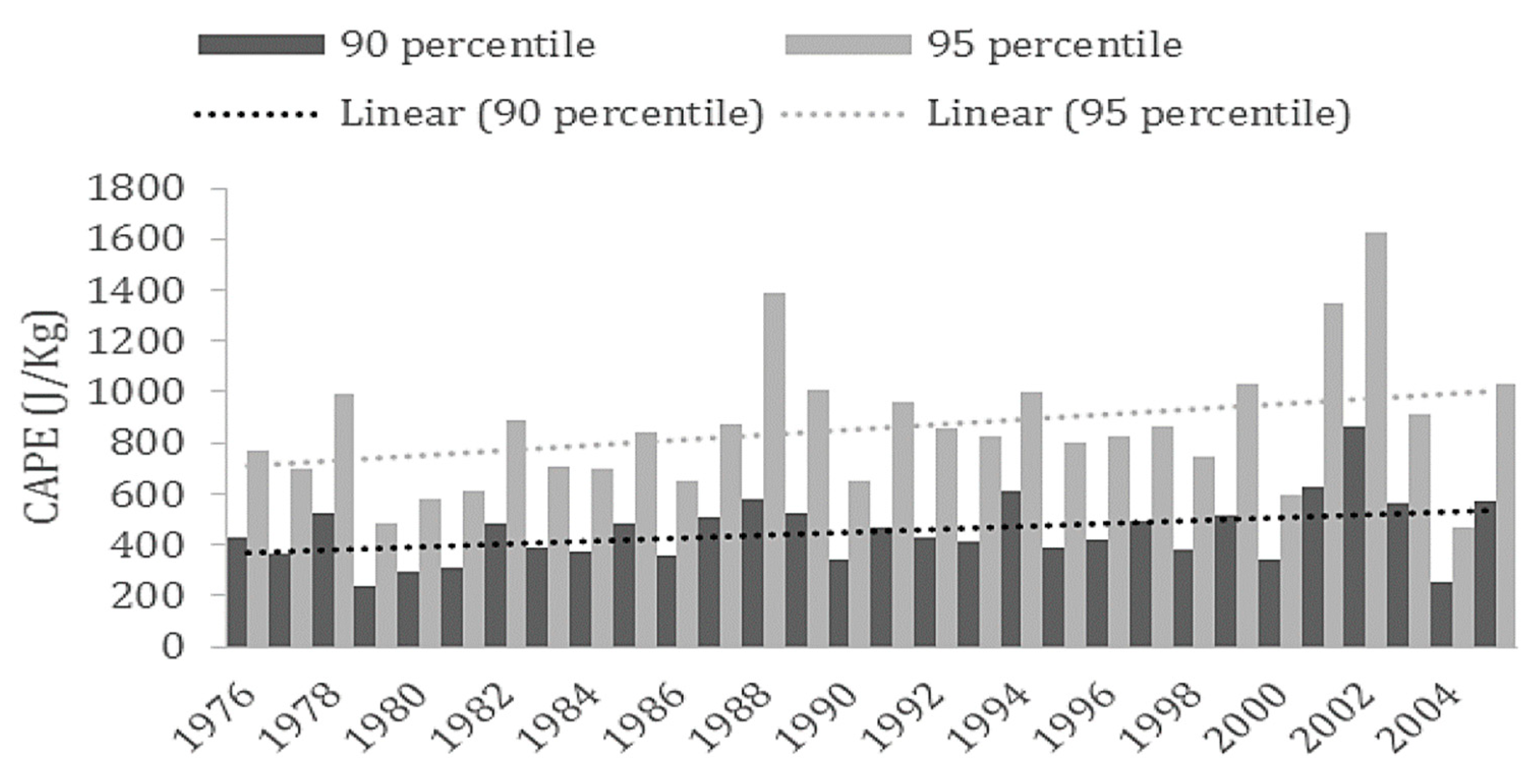
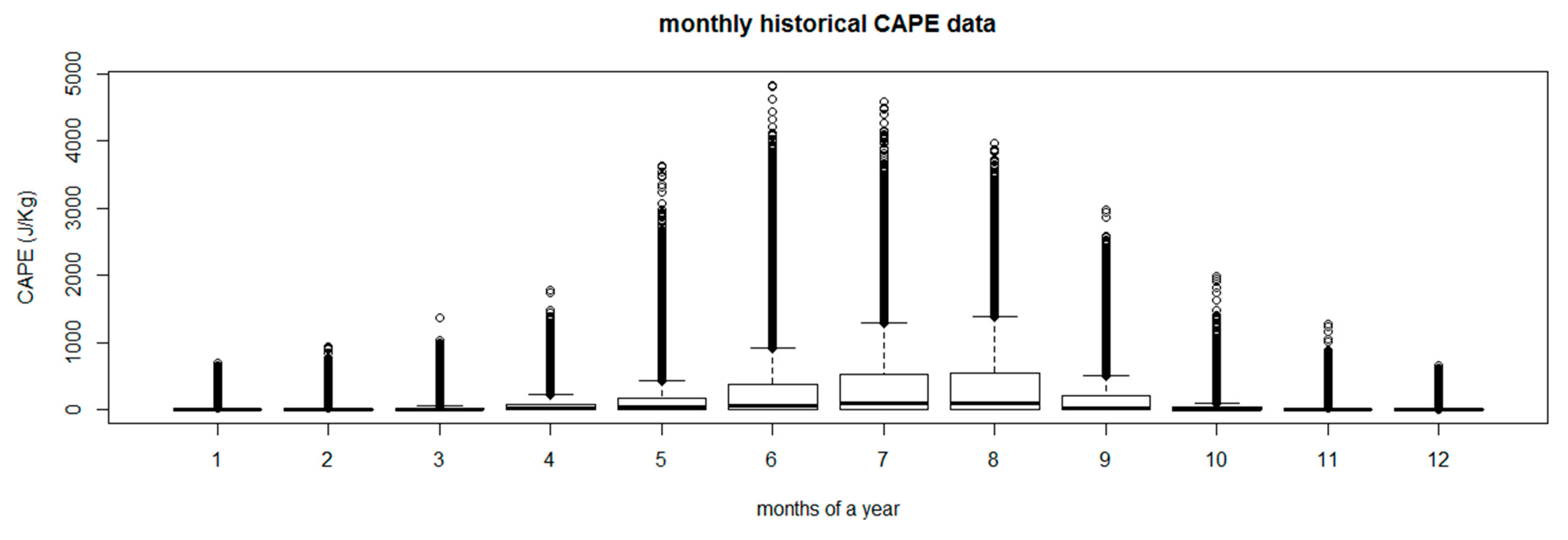
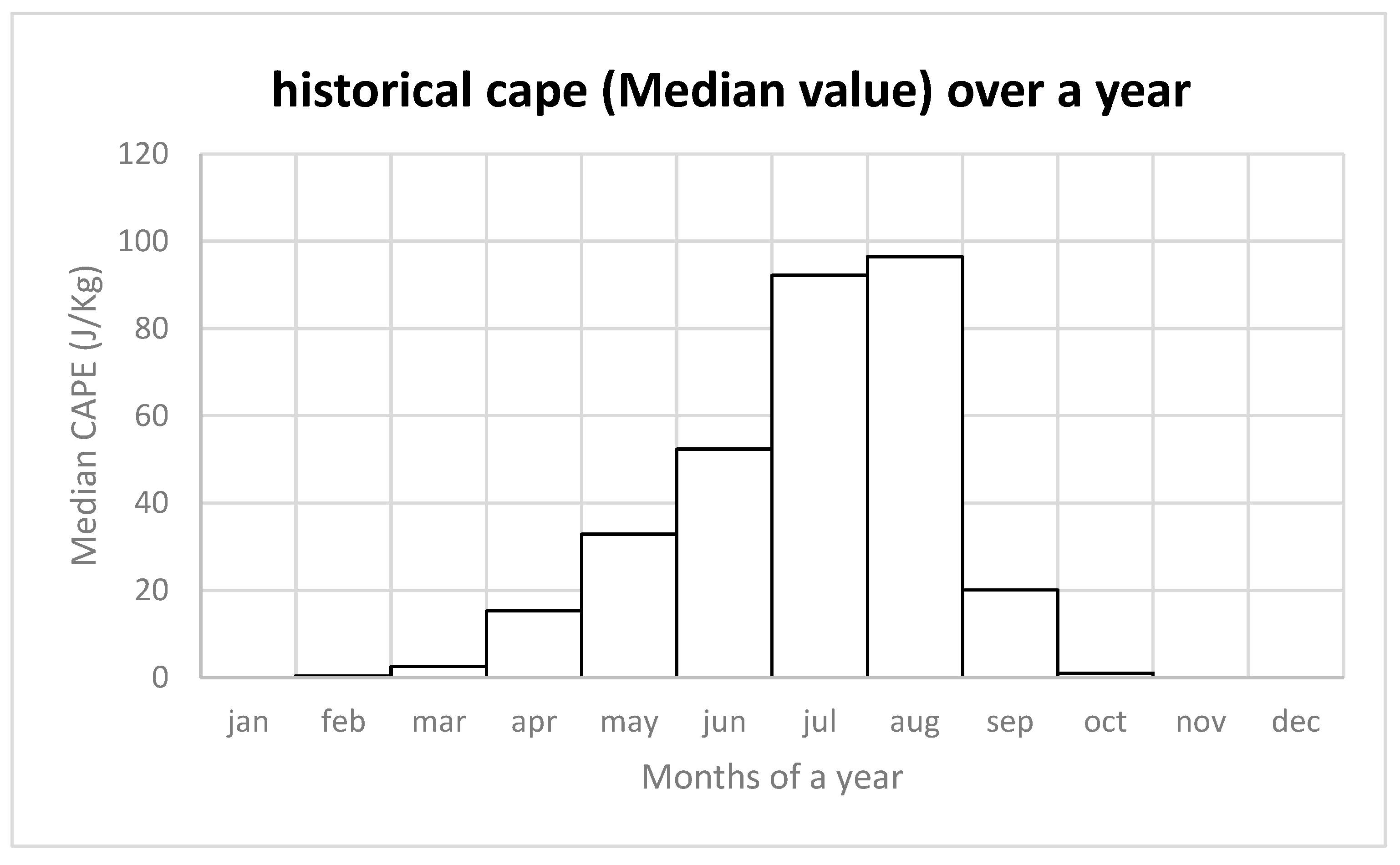
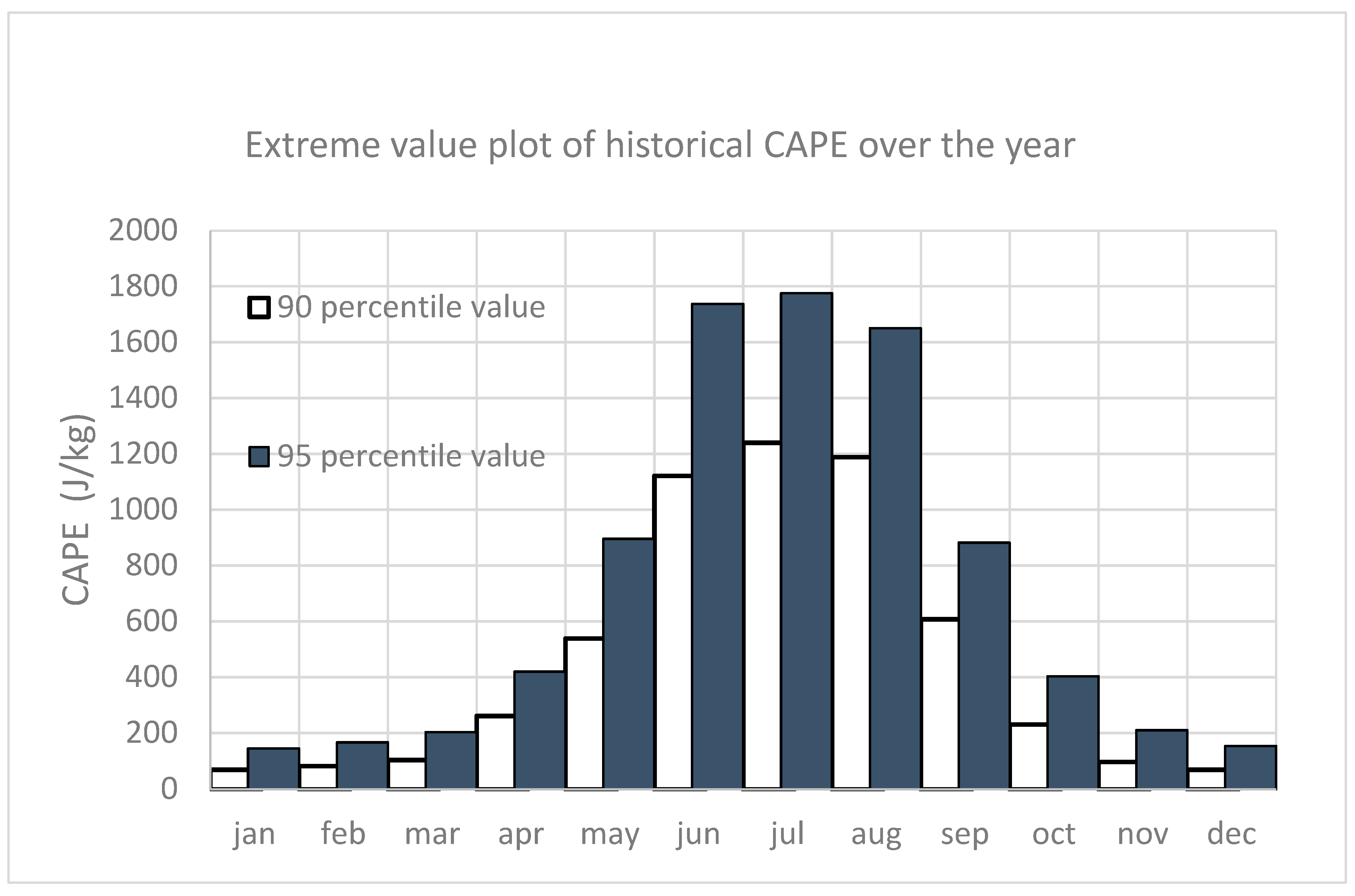
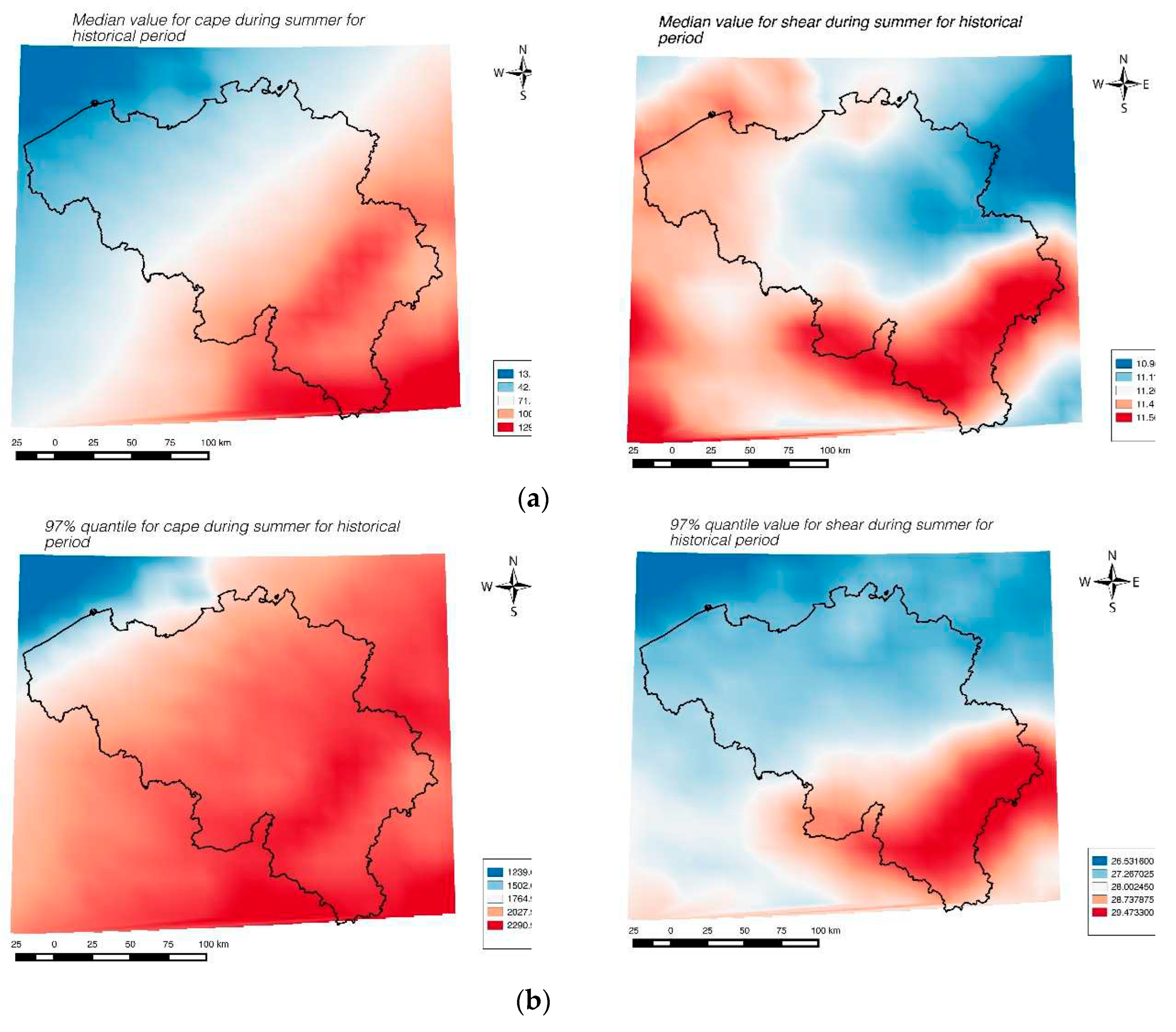
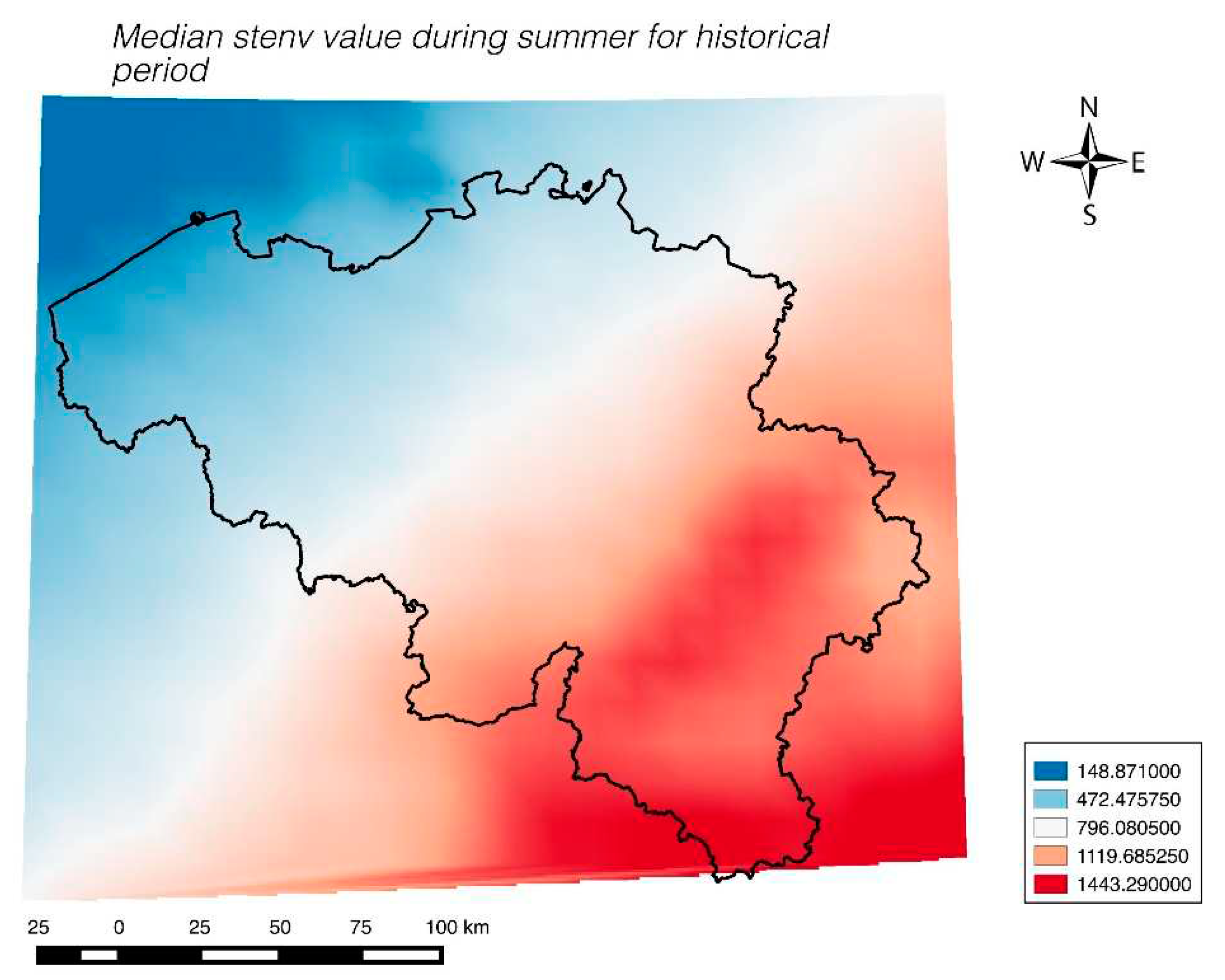
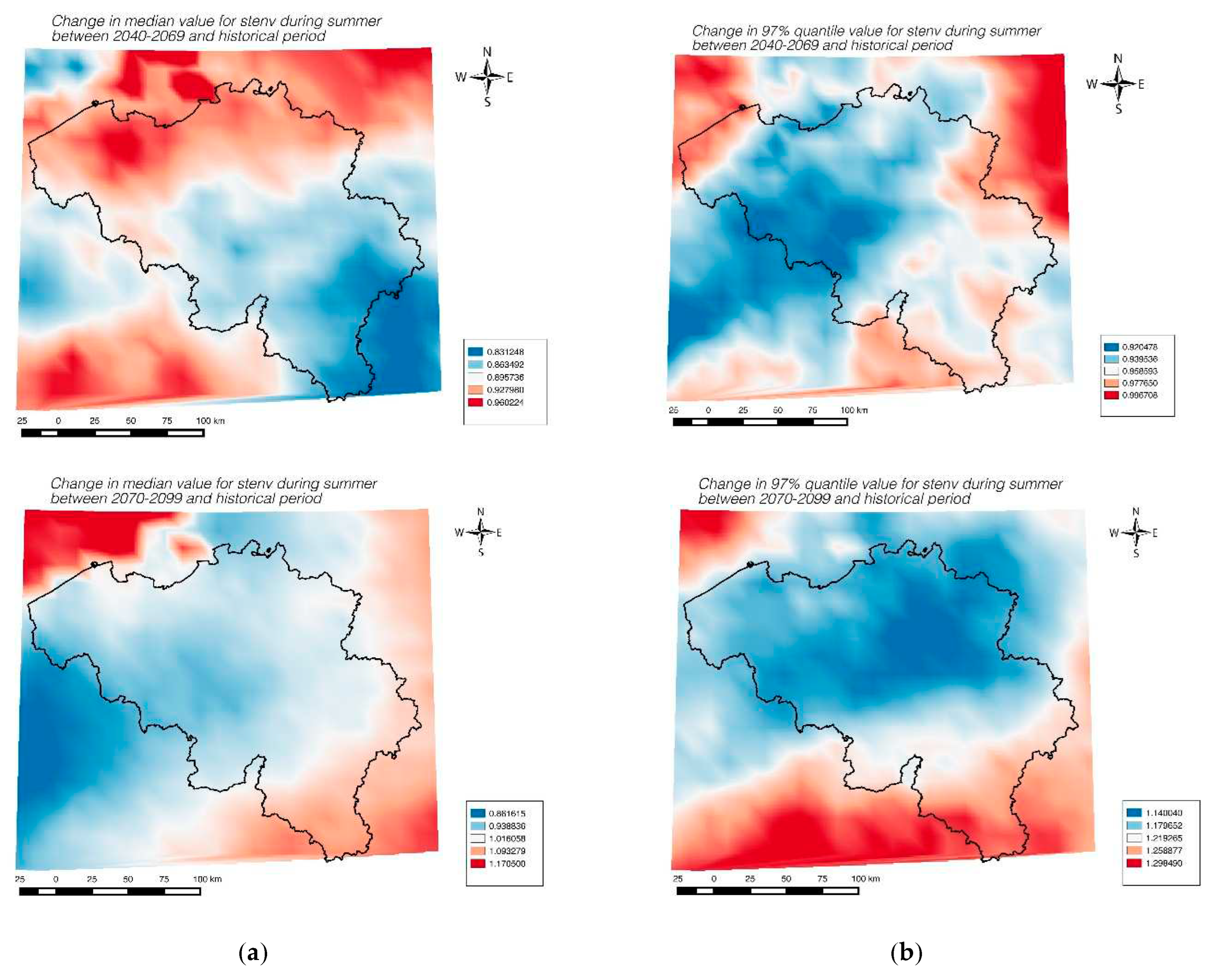
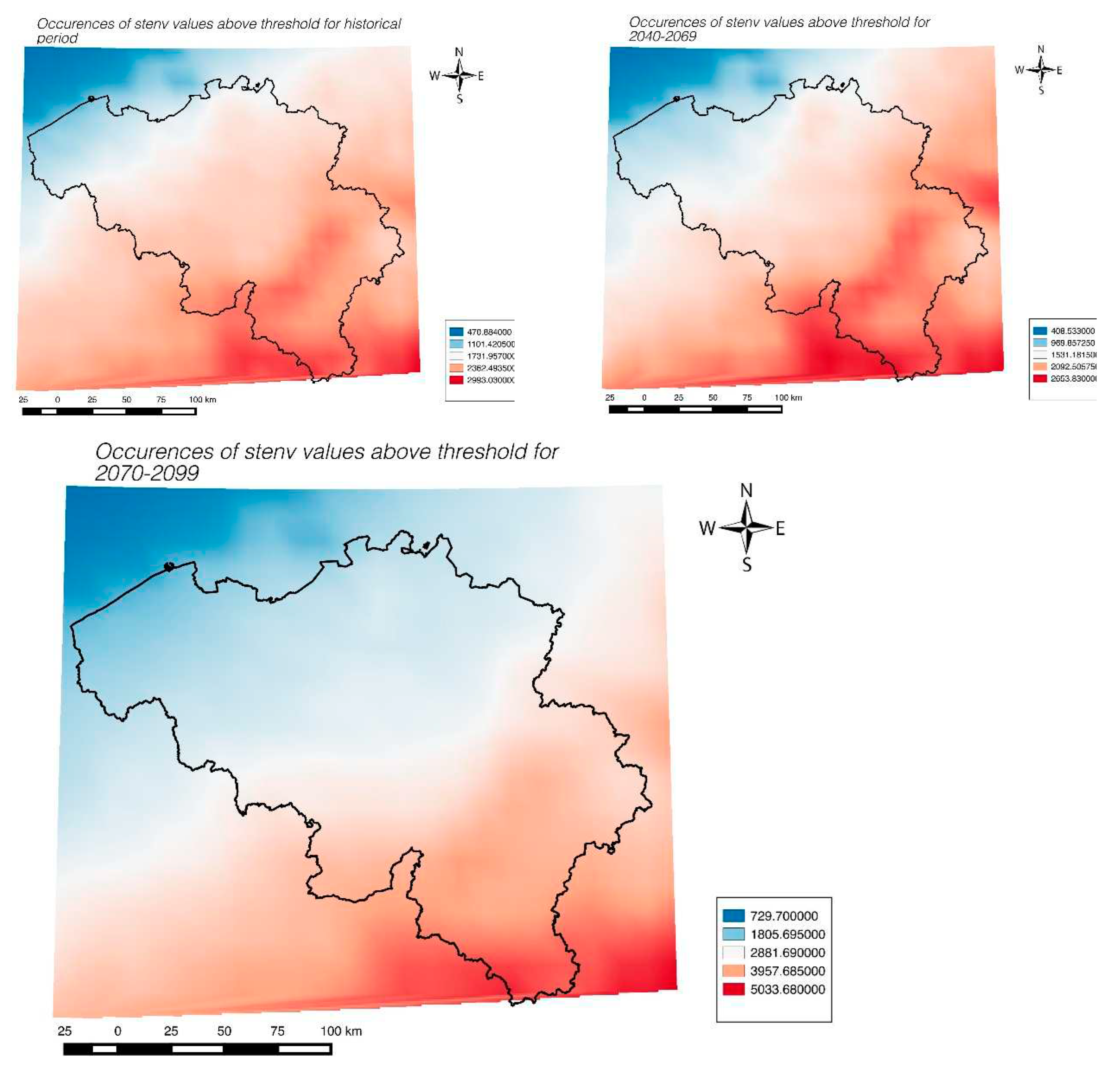
| Statistics | Entire grid Shear (historical) | 12x11 grid shear (historical) |
Entire grid CAPE (historical) | 12x11 grid CAPE (historical) |
|---|---|---|---|---|
| 90% quantile (summer) | 27.83 | 28.07 | 2105.8 | 2154.5 |
| Median (summer) | 16.13 | 16.17 | 519.25 | 538.92 |
| Time Period | Maximum Shear value range in 90% quantile with mean value (--) in m/sec | Maximum Shear value range in 95% quantile with mean value (--) in m/sec | Maximum Shear value range in 97% quantile with mean value (--) in m/sec | Maximum Shear value range in 99% quantile with mean value (--) in m/sec |
| 1977 to 2005 | 27.2- 28.2 (27.8) | 31-31.7 (31.4) | 33.2-33.8 (33.5) | 37.1-37.3 (37.2) |
| 2041 to 2069 | 26.5- 27.5 (27.1) | 30.3-31 (30.7) | 32.7-33.3 (33) | 36.8-37 (36.9) |
| 2071 to 2099 | 26.4-27.4 (27) | 30.1-30.8 (30.5) | 32.5-33.1 (32.8) | 37.4-37.6 (37.5) |
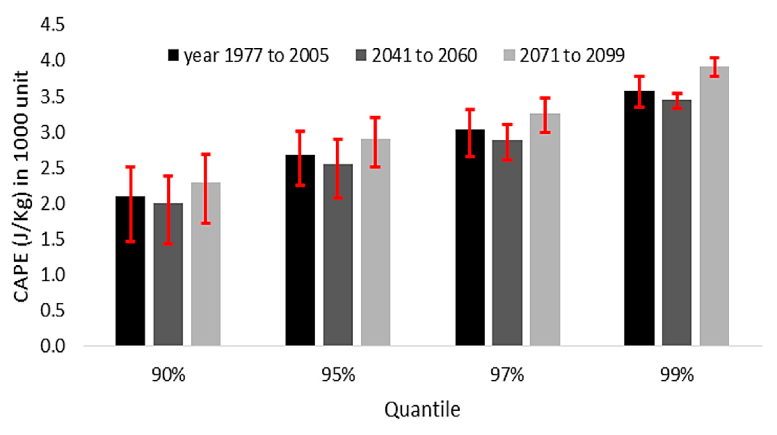
| Time Period | Maximum CAPE value range in 90% quantile with mean value (--) in J/kg | Maximum CAPE value range in 95% quantile with mean value (--) in J/kg | Maximum CAPE value range in 97% quantile with mean value (--) in J/kg | Maximum CAPE value range in 99% quantile with mean value (--) in J/kg |
| 1977 to 2005 | 1466- 2516 (2106) | 2258-3008 (2688) | 2652-3322 (3032) | 3353-3783 (3583) |
| 2041 to 2069 | 1360-2410 (2000) | 2125-2875 (2555) | 2504-3174 (2884) | 3217-3647 (3447) |
| 2071 to 2099 | 1659-2709 (2299) | 2472-3222 (2902) | 2880-3550 (3260) | 3684-4114 (3914) |
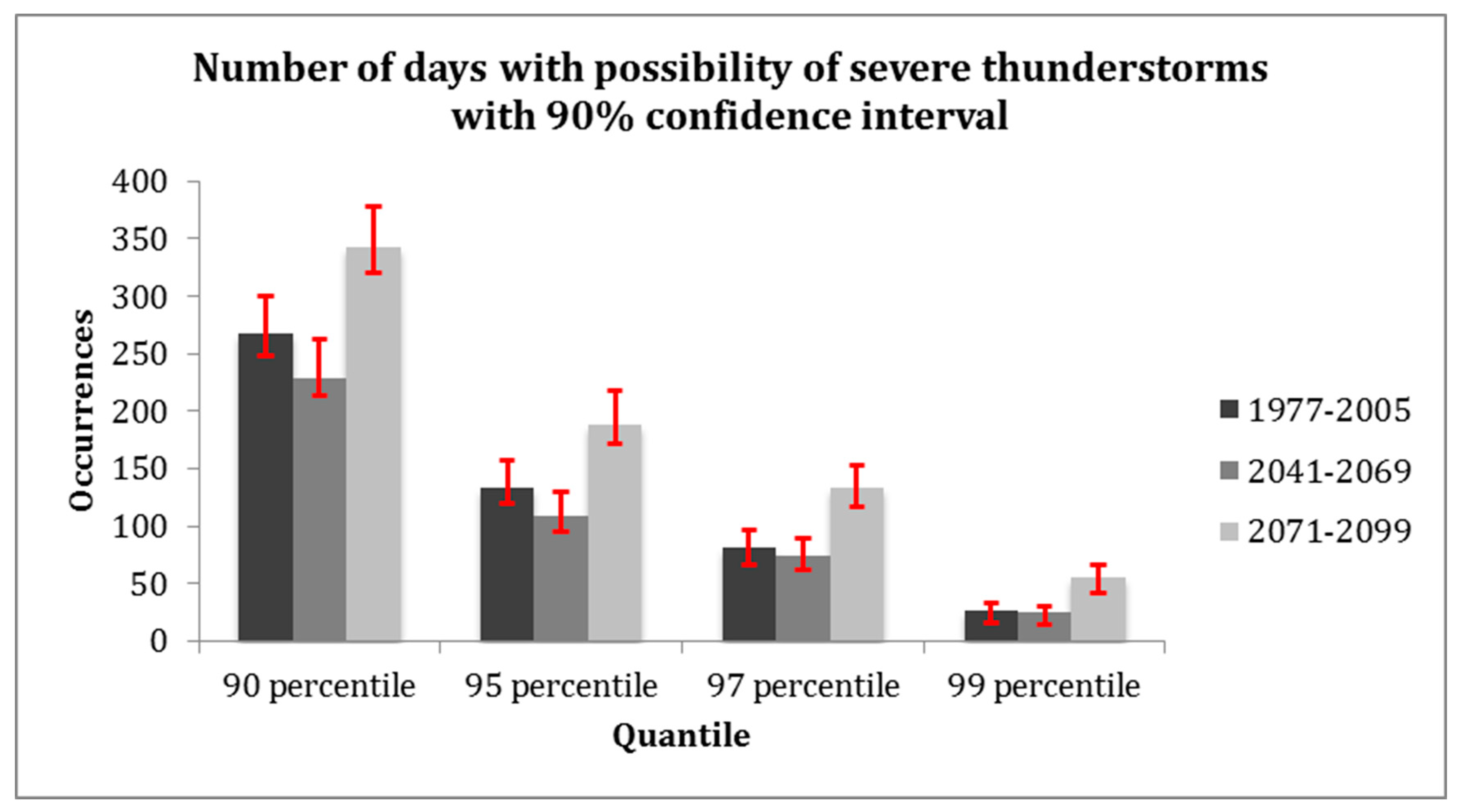
| Quantiles | 1977-2005 (range given with mean) | 2041-2069(range given with mean) | 2071-2099 (range given with mean) |
| 90% | 248.5-300.5 (267) | 214.1-262.1 (229) | 320.6-378.6 (342) |
| 95% | 120.2-157.7 (134) | 95-129.5 (109) | 172.4-218 (188) |
| 97% | 66.99-96.95 (81) | 61.44-90.22 (75) | 117-153.6 (134) |
| 99% | 16.32-33.11 (27) | 14.48-30.08 (25) | 42.33-65.86 (55) |
Disclaimer/Publisher’s Note: The statements, opinions and data contained in all publications are solely those of the individual author(s) and contributor(s) and not of MDPI and/or the editor(s). MDPI and/or the editor(s) disclaim responsibility for any injury to people or property resulting from any ideas, methods, instructions or products referred to in the content. |
© 2023 by the authors. Licensee MDPI, Basel, Switzerland. This article is an open access article distributed under the terms and conditions of the Creative Commons Attribution (CC BY) license (http://creativecommons.org/licenses/by/4.0/).


