1. Introduction
1.1. The problem
The financial success of a business can be evaluated by its profit and profitability. Profit refers to the absolute measure of earnings minus the expenses involved in achieving a particular outcome. In a market-driven economic system, it is imperative for entrepreneurs to prioritize profit realization, as failure to do so compromises the sustainability and longevity of their enterprise [
1]. Apart from maximizing profits, though, the goal of any agricultural enterprise is also to minimize costs.
Profitability represents a relative measure of a company's effectiveness, allowing for a comparison between the achieved outcome and the associated costs [
2]. To ensure the profitability of an agricultural enterprise, efficient management is essential, typified by tasks such as soil tillage, crop planting, irrigation, weed management, pest, and disease control, and harvesting.
Further, effective farm management requires a combination of knowledge, skills, and experience, and often involves the use of technology and data-driven decision-making. The key lies in effectively utilizing production resources and adopting advanced techniques to produce crops [
3]. It is crucial for businesses to prioritize maximizing their profits within the limitations of available resources, including financial and credit resources, material support for production, and the necessary skills to carry out the tasks of the workforce [
4].
Precision Agriculture (PA) is one of several methodologies which can improve farm management by providing timely, thorough, site-specific crop information within a decision-making framework. Data can be retrieved from a variety of sources, such as soil sampling, sensors, weather stations, satellite or drone images, and yield monitors.
As a tool facilitating farmers to more efficiently manage their land, precision agriculture significantly and variously impacts farm management. According to global trends, the application of precision agriculture worldwide is estimated to increase in the next four years, with the market value doubling from 17.41 billion U.S.$in 2022 to 34.1billion U.S.$in 2026 [
5].
The main goal of precision agriculture research is to define a decision support system (DSS) for whole farm management with the aim of optimizing returns on inputs while preserving resources [
6,
7,
8]. However, farming is a complex endeavor involving many factors and inputs, such as land cost, labor, expensive machines and various tools, fertilizers, pesticides, and irrigation. In most cases, farming activities are not properly logged, at least not in a systematic and analytic way, while most data are fragmented, dispersed, and difficult to use [
9].
According to a recent review based on 23-year meta-analysis [
10], profitability, consultancy, and computer use had only a moderate effect on the adoption of precision agriculture. However, these findings should be viewed cautiously due to issues of sample size and heterogeneity embedded in some of the reference studies, while at the same time, other factors had a negligible effect on adoption. Precision agriculture must be discriminated from “smart agriculture”, regarding the concept of site-specificity. Smart agriculture is associated with various types of sensors used (soil, moisture, climatic, etc.) to derive crop information (and potentially return a decision), regardless satisfaction of within-field spatial variability, as it happens with precision agriculture practices.
1.2. State of the art
Lately, several farm management platforms and technologies have become available to support precision and smart agriculture applications; below are some indicative platforms in English available in the market:
Climate FieldView: An integrated digital platform that collects and analyzes field data, helping farmers make more informed decisions regarding crop management, planting, and harvesting. The available tools allow farmers to manually delineate management zones (
https://www.fieldview.com.au/).
Farmers Edge: A comprehensive smart agriculture platform that includes field-centric data collection, satellite imagery, variable rate technology, and weather analytics to optimize farm operations (
https://farmersedge.ca/).
Agworld: A collaborative farm management platform that allows farmers, agronomists, and other stakeholders to work together on planning, budgeting, and reporting of farm activities. It incorporates add-in applications for specific works (e.g. Satamap for satellite image display) (
https://www.agworld.com/us/).
Taranis: This platform uses artificial intelligence (AI)-driven image analysis, combining high-resolution aerial imagery and field-level weather data to detect and predict pest and disease issues, enabling farmers to make proactive decisions (
https://www.taranis.com/).
Sentera: A platform that integrates drone and satellite imagery with sensor data, enabling farmers to monitor plant health, track growth, and identify potential issues (
https://sentera.com/).
John Deere Operations Center: A web-based platform that helps farmers track equipment, manage field data, and analyze agronomic information to optimize their operations (
https://operationscenter.deere.com/).
Topcon Agriculture: A suite of visualization and decision-making tools including auto-steering systems, variable rate control, yield monitoring, and farm management software (
https://tap.topconagriculture.com/).
Raven Industries: Providing automations like guidance and steering systems, application controls, and field computers to help farmers optimize their operations (
https://ravenind.com/).
Most of the above solutions -although quite technologically advanced- respond partially or even inadequately to the need for an integrated site-specific management. Moreover, economic records stored in the database (if they exist) are not always effectively linked to relevant precision farming data, or (even if they are), the platform leaves the user alone to carry out the analysis or make out the decisions. Therefore, in all cases there is a gap between available data, decision making on site-specific applications, and their economic evaluation.
To bridge this gap between farm management and precision agriculture applications, two Greek enterprises, Agrostis and Ecodevelopment, cooperated in 2022 to incorporate a site-specific fertilization service (namely PreFer) into a pre-existing Farm Management Information System (FMIS) (namely ifarma) [
9].
ifarma was introduced to the Greek market in 2014 by Agrostis, as a cloud-based farm management information system (FMIS). The data model of ifarma integrates all information relevant to a farm, such as fields and land parcels, crops, farming activities on fields and inputs and resources used to plan and execute these activities. This data model organizes the information in a hierarchical manner, where the farm is at the top. Today, ifarma is a well-known trademark recognized as the best farm management software for agricultural holdings in Greece [
11].
PreFer service developed by Ecodevelopment, produces prescription maps, which together with a variety of spatial layers (including soil properties, agronomic information, crop indices, statistical and predictive climatic parameters, and yield records) become available to the farmers on 5-meter spatial resolution on a regular basis. The prescription maps are created within a GIS, where big data are analyzed using machine learning methodologies [
12].
1.3. Objectives
Going a step further, the objective of this research was to offer a complete and easy-to-use commercial solution for profitability assessment of precision agriculture applications in extended crops on an annual basis.
Accordingly, a new module was developed within the ifarma farm management platform using PreFer functionalities, especially its mapping environment and algorithms, thus facilitating interoperability, swiftness, and ease. In this respect, the next Section will present the materials and methods employed,
Section 3 will demonstrate the results along with discussion and Section 4 will provide the main conclusions of this work.
2. Materials and Methods
2.1. System architecture
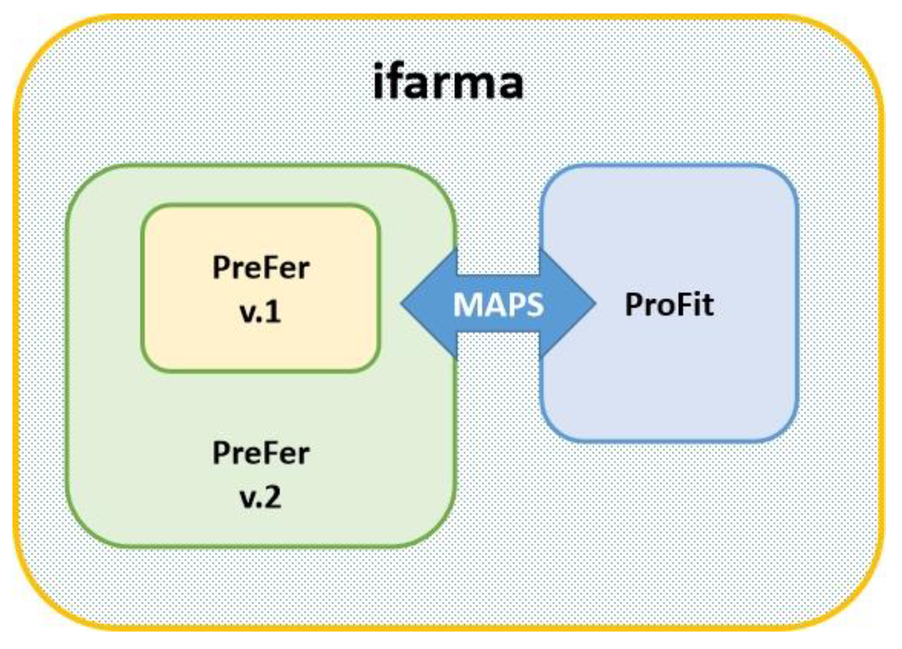
The new profitability module, namely, ProFit, is an independent module of the ifarma FMIS, in terms of interface and algorithms, although it cooperates with the PreFer module of ifarma, for exchanging map data. More specifically, ProFit takes spatial data from the PreFer database as input into its algorithms and returns output maps for display in the map viewer of PreFer. In this way, the original PreFer (say v.1) is upgraded into a new version (say v.2) after integrating with ProFit (
Figure 1).
Going a step further, the objective of this research was to offer a complete and easy-to-use commercial solution for profitability assessment of precision agriculture applications in extended crops on an annual basis.
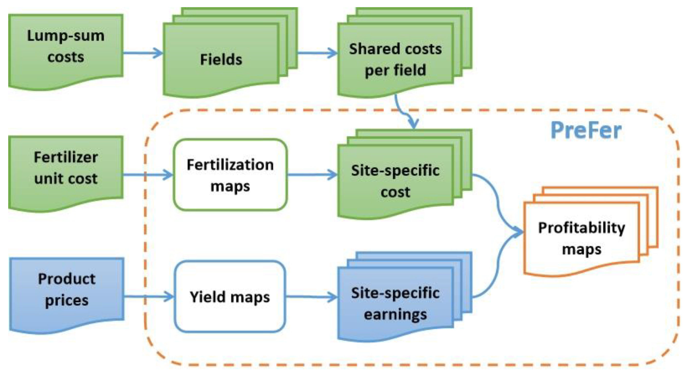
ProFit alone comprises two components (
Figure 2). A site-specific cost component, which is fed by the database of PreFer, where the precision agriculture applications are stored and displayed. A shared cost component for other (non-precision agriculture) practices, where the required records are manually entered as lump sum amounts. The site-specific cost component takes input from two kinds of spatial data: a) the fertilizer application maps and b) the yield maps. The former is used to calculate fertilization cost at every surface unit (of 25 m
2) after the multiplication of the fertilizer’s rates with its corresponding unit cost; the latter, meanwhile, are used to calculate earnings at every surface unit after the multiplication of the yield with the price of the corresponding cultivar in the market.
The shared cost component holds the lump sum amounts per expenditure category. The distribution of these lump sum costs is then based on an empirical classification of the fields of the farm according to a degree of difficulty (or weighting factor) on a categorical scale of 1-5, with ‘1’ corresponding to the easiest field and ‘5’ to the most difficult for each of the agriculture practices applied (e.g., soil tillage, irrigation, weed management, etc.).
The output data will be in two forms: a) descriptive statistics of cost, earnings, and profit per field; and b) profitability maps (cost, earnings, and profit maps) at a 25-m2 surface unit. The calculations will be done automatically according to embedded formulas.
2.2. Data requirements
The data entry of the shared cost records in ProFit is carried out manually through a new form which is divided into two sections, each corresponding to a number of agricultural practices. The site-specific data will be read from the maps stored in the PreFer database.
The shared cost data are related to total annual amounts for the entire cultivation and can be divided into the following categories (using a common ordering regardless change of category):
Section A (related to categorized total annual costs):
Land rent
Seeds
Irrigation
Fertilizers
Weed killers
Pesticides/Insecticides
Harvest
-
Machinery
- a)
Depreciation
- b)
Maintenance
- c)
Spare parts
Section B (related to total annual costs per field):
- 9.
Land rent (absolute amounts)
- 10.
-
Degree of difficulty per field for shared cost (weighting factor: 1-5)
- d)
Seeds
- e)
Irrigation
- f)
Fertilizers
- g)
Weed killers
- h)
Pesticides/Insecticides
- i)
Harvest
- j)
Machinery
2.3. Algorithms developed
A set of interrelated functions have been setup for ProFit, which carry out arithmetic, categorical, and logical operations, and transfers of tabular data. The overall arrangement is integrated and executed in a prototype Excel spreadsheet, where all internal functions and options and the external data feed are arranged. The monetary rate unit is set to euros per hectare (€/ha), the fertilizer amounts in kilograms per hectare (kg/ha), and the yield in tonnes per hectare (t/ha) (
Figure 3).
The basic formula for cost, earnings, and profit calculations applied per field, is shown simplified below:
Cost =
Field Rental Cost +
Field Shared Cost for Agricultural Practice [
1] +
Field Shared Cost for Agricultural Practice [
2] +
Field Shared Cost for Agricultural Practice [
3] +
…
Field Shared Cost for Agricultural Practice [8c] +
Quantity of Fertilizer-1 [Input from the Fertilization Maps of PreFer database] x Price of Fertilizer-1 (manual input in relevant table) +
… (as many times as the number of fertilizers, n)
Quantity of Fertilizer-n [Input from the Fertilization Maps of PreFer database] x Price of Fertilizer-1 (manual input in relevant table)
Earnings = Yield (t/ha) [Input From the Yield Map] x Cultivar Price (monetary unit/kg) [Input from the Crop List]
Profit = Earnings – Cost
For splitting the shared cost lump sums of the different agricultural work categories into cost items per field, a stepwise procedure is followed (
Figure 4):
First, the rate of difficulty of each field is multiplied by the field’s extent and then divided by the number of fields under consideration, to give a weighted rate of difficulty.
Then, the weighted rate of difficulty of each field is divided by the total weighted rate of difficulty to give the cost share for the field (for each of the shared cost categories).
Finally, the cost share of every field is multiplied by the total cost of the category and divided by the number of fields to give the absolute cost per field (for that cost category).
Therefore, for every category, the algorithm retrieves the lump sum amount for the entire cultivation from a manually filled table and the field extents from the farm’s geodatabase (i.e. from PreFer). Thus, the only inputs required by the algorithm are the rates of difficulty per field and for each work category. An internal control function will check if the earlier entered lump sum for the working cost category is equal to the one calculated by the algorithm.
3. Results and Discussion
3.1. System functionality
The new module ProFit comprises a spatial and a non-spatial component. The spatial component is developed in the pre-existing module PreFer within the ifarma FMIS. As a result, the output maps of ProFit follow the same standards as that of the PreFer module, i.e., a spatial resolution of 5 meters (surface unit of 25 m2) and a classification of the original values into 7 categories.
The non-spatial components include output tables which at the same time contain the entire input information. Thus, the user gets the whole economic picture of the cultivation in a single tabular arrangement.
3.2. System interface
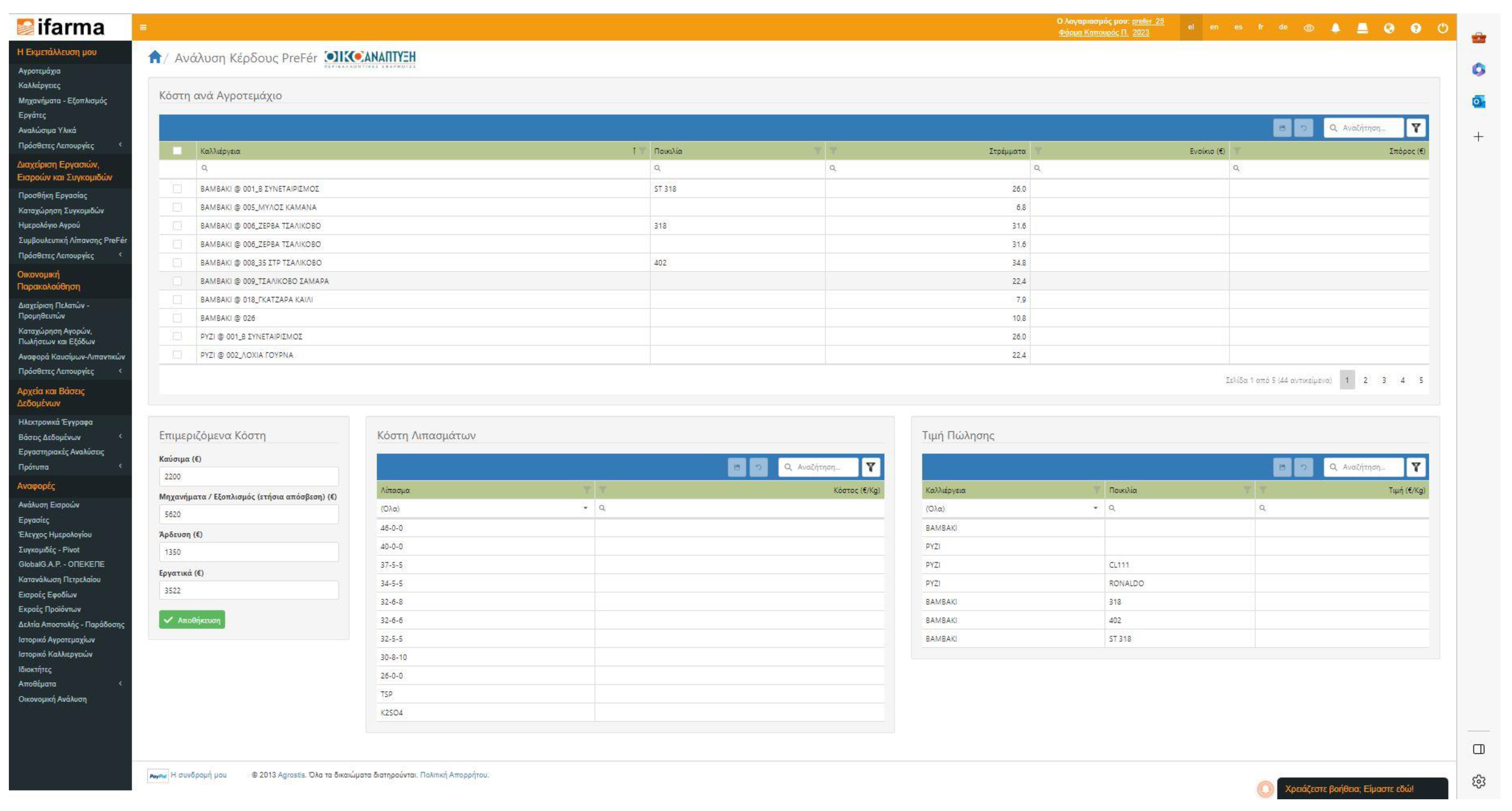
The ProFit module is available as an option in the main menu of the ifarma interface, specifically in the ‘Management of works, inputs, and yields’ group (currently only in Greek). By clicking the ProFit button (set below the ‘PreFer’ option), the input form for entering values for the required economic items is launched in a single web page (
Figure 5). For convenience, the output fields are displayed in a different form after the execution of the calculations and can be exported to spreadsheets.
Apart from the tabular output data (e.g., statistics per field and the entire cultivation), which are displayed on a different web page of the ifarma environment, the output maps are displayed within the PreFer map viewer. The options for displaying the cost, earnings, and profit maps for every cultivation are available inside the ‘Performance’ group of options in the PreFer map viewer menu (which also includes the yield maps).
3.3. Experiences
Most of the existing platforms in the market are top-down, originating from the need of an already established market player to promote its products, services, or goods through the concepts of precision agriculture. In most cases, these platforms provide financial management as a parallel service to another main service, e.g., fleet management, crop calendar, etc.
Conversely, ProFit on ifarma follows a bottom-up approach, starting from the applications and considering all the farming details to conduct a thorough economic analysis, while enabling spatially distributed outputs in terms of maps.
The development team was assisted significantly by several farmers who implemented precision agriculture over the course of years, through their ideas and experience and by using and testing the module with authentic farming data from the 2022 cultivation year in Greece.
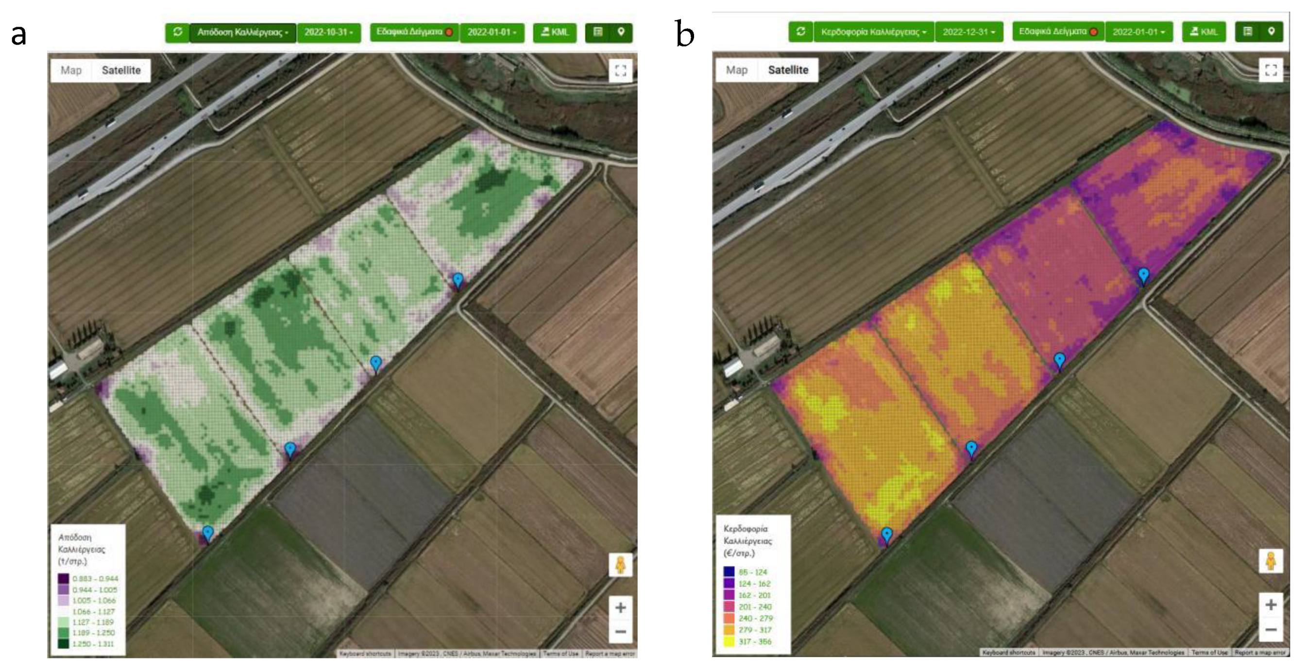
Using real data combined with some notional options, for example, in the selection of the difficulty factors per field, to test the module under extreme data ranges it was noticed that yield maps might be quite different from profitability maps (especially between fields) (
Figure 6).
5. Conclusions
In this research, an innovative module for assessing the profitability of precision agriculture applications was developed, namely ProFit. In terms of architecture, ProFit is embedded within a cloud-based farm management information system, namely “ifarma”, while taking advantage of pre-existing functionalities, such as a precision agriculture database provided by other ifarma modules, like PreFer.
ProFit offers an easy-to-use interface, which encourages farmers to enter economic records quickly and reliably, while using an empirical method to share apportionable expenditures between fields (when and where site-specific maps are not available). At the same time, it uses the map view environment of PreFer to display the profitability maps.
Future work will focus on widening the range of precision agriculture practices (I.e., beyond fertilization) within ProFit, such as soil tillage, seeding, irrigation, weed management, and crop protection.
Author Contributions
Conceptualization, C.K., M.C., and S.M.; methodology, C.K., M.C., and V.V.; software, K.S. and V.V.; validation, M.C., A.M., and K.S.; formal analysis, C.K. and M.C.; investigation, M.C. and O.T.; resources, M.C. and O.T.; data curation, C.K. , A.M. and K.S..; writing—original draft preparation, C.K., M.C., and O.T.; writing—review and editing, M.C., and O.T.; visualization, A.M., and K.S; supervision, S.M. and V.V.; project administration, V.V.; funding acquisition, S.M. All authors have read and agreed to the published version of the manuscript.
Funding
This research received no external funding.
Informed Consent Statement
Not applicable.
Data Availability Statement
Data will be made available on request.
Acknowledgments
Special thanks to Mr. Kostas Kravvas and Mr. Panagiotis Goutas, rice farmers in Greece, for their ideas and the permission to use their data for the demonstration needs of this work.
Conflicts of Interest
The authors declare no conflict of interest.
References
- Barkley, A.; Barkley, P. W. Principles of Agricultural Economics, 1st ed.; Routledge: Abingdon-London, United Kingdom, 2013; pp. 1–384. [Google Scholar] [CrossRef]
- Epifanova, I. Y.; Humeniuk, V. S. Profitability of the enterprise: modern approaches to defining the essence. Econ Soc 2016, 3, 189–192. [Google Scholar]
- Smoliy, L.V. Formation of the results of economic activity of Agricultural Enterprises. Collected Works of Uman National University of Horticulture 2019, 95, 115–128. [Google Scholar] [CrossRef]
- Shmatkovska, T. О.; Dziamulych, M.; Vavdiiuk, N.; Petrukha, S.; Koretska, N.; Bilochenko, A. Trends and Conditions for the Formation of Profitability of Agricultural Enterprises: A Case Study of Lviv Region, Ukraine. Univers. J. Agric. Res. 2022, 10, 88–98. [Google Scholar] [CrossRef]
- Shahbandeh, M. Smart Agriculture: Market Size Worldwide 2026. Available online: https://www.statista.com/statistics/720062/market-value-smart-agriculture-worldwide/ (accessed on 20 April 2023).
- McBratney, A. B.; Whelan, B.; Ancev, T.; Bouma, J. Future Directions of Precision Agriculture. Precis. Agric. 2005, 6, 7–23. [Google Scholar] [CrossRef]
- Whelan, B.; McBratney, A. B. Definition and interpretation of potential management zones in Australia. In Solutions for a Better Environment. In Proceedings of the 11th Australian Agronomy Conference, Geelong, Victoria, Australia, 0–11., 2-6 February 2003. [Google Scholar]
- Singh, P.; Pandey, P. C.; Petropoulos, G. P.; Pavlides, A.; Srivastava, P. K.; Koutsias, N.; Deng, K. A. K.; Bao, Y. Hyperspectral remote sensing in precision agriculture: present status, challenges, and future trends. In Earth Observation, Hyperspectral Remote Sensing; Pandey, P. C., Srivastava, P. K., Balzter, H., Bhattacharya, B., Petropoulos, G. P., Eds.; Elsevier eBooks, 2020; pp. 121–146. [Google Scholar] [CrossRef]
- Karydas, C. G.; Chatziantoniou, M.; Stamkopoulos, K.; Iatrou, M.; Vassiliadis, V.; Mourelatos, S. Embedding a precision agriculture service into a farm management information system- ifarma/PreFer. Smart Agric. Technol. 2023, 4, 100175. [Google Scholar] [CrossRef]
- Tey, Y.S.; Brindal, M. A meta-analysis of factors driving the adoption of precision agriculture. Precis. Agric. 2022, 23, 353–372. [Google Scholar] [CrossRef]
- Paraforos, D.S.; Vassiliadis, V.; Kortenbruck, D.; Stamkopoulos, K.; Ziogas, V.; Sapounas, A. A.; Griepentrog, H.W. Multi-level automation of farm management information systems. Comput. Electron. Agric. 2017, 142, 504–514. [Google Scholar] [CrossRef]
- Iatrou, M.; Karydas, C.; Tseni, X.; Mourelatos, S. Representation Learning with a Variational Autoencoder for Predicting Nitrogen Requirement in Rice. Remote Sens. 2022, 14, 5978. [Google Scholar] [CrossRef]
|
Disclaimer/Publisher’s Note: The statements, opinions and data contained in all publications are solely those of the individual author(s) and contributor(s) and not of MDPI and/or the editor(s). MDPI and/or the editor(s) disclaim responsibility for any injury to people or property resulting from any ideas, methods, instructions or products referred to in the content. |
© 2023 by the authors. Licensee MDPI, Basel, Switzerland. This article is an open access article distributed under the terms and conditions of the Creative Commons Attribution (CC BY) license (http://creativecommons.org/licenses/by/4.0/).


