
Submitted:
03 July 2023
Posted:
04 July 2023
You are already at the latest version
Abstract
Forests, integral to human civilization, hold immense value and play a vital role in maintaining ecological harmony. Despite India's goal of extensive forest coverage, significant progress is still needed. Uncontrolled forest fires pose a severe threat, particularly in Uttarakhand's Pauri Garhwal district. To address this challenge, a comprehensive study examined surface and subsurface hydrological factors influencing the forest fire occurrences, such as elevation, aspect, slope, vegetation, proximity to human settlements, proximity to waterbodies, Active faults and lineament density. A total of 15 such factors were integrated with advanced techniques of remote sensing and GIS and coupled with historical fire data to create a precise forest fire risk map using the support vector machine algorithm. Forest fire risk map was classified into 5 distinct risk zones, Very High Risk (47.38 Km2), High Risk (275.98 km2, Moderate Risk (985.49 km2), Low Risk (1741.17 km2) and Very Low Risk (2374.11 km2) aiding in proactive fire management. By embracing this innovative tool, decision-makers can protect forests, preserve biodiversity, and ensure a sustainable future for generations to come.
Keywords:
Forest Fire 1
; Pauri-Gharwal 2
; Surface and Subsurface Hydrology 3
; Remote Sensing and GIS 4
; Support Vector Machine 5
1. Introduction
Forests are vital natural resources and have played a significant role in human civilization since ancient times [1]. The status of forests is an indicator of regional ecological conditions [2]. The National Forest Policy of India aims to have 33% of the country's land covered with trees and forests, but currently, only 21.71% of the land area is forested [3]. Forest fires are a natural phenomenon that influences landscape patterns, plant communities, nutrient availability, and biodiversity [4]. The fire hazard, which refers to the accessibility of fuel sources for burning, plays a crucial role in fire occurrence [5]. Climate change has increased the frequency of fire events globally, leading to land degradation, soil erosion, and impacts on soil ecology and water hydrology [6,7,8]. Forest fires can have both beneficial and destructive effects. They facilitate the release of nutrients and the germination of seeds and buds, but severe and recurrent fires can destroy vegetation, biodiversity, and timber wealth, increase soil erosion, contribute to air pollution, and raise global temperatures [9,10,11]. Human activities and underlying causes, such as financing patterns, land-use regulations, and climate factors like El Nino, contribute to forest fires. Large-scale land clearing authorized by the government itself has been a significant cause of intense fires [12,13,14]. Although fires have a role in forest management, unchecked fires can cause extensive damage to forests and wildlife. Forest fires are often noticed after significant land has already been consumed, making control and suppression difficult [15]. The frequency of forest fires is increasing globally, with Asia experiencing a significant number of incidents [16,17]. Various factors can ignite a fire, including human activities like smoking or campfires, as well as natural causes such as high temperatures, lightning, or concentrated sunlight [18,19]. Forest fires progress from surface fires to crown fires, causing extensive damage and releasing large amounts of carbon monoxide [15]. Forest fires pose a significant environmental problem in tropical biomes, leading to vegetation depletion, atmospheric pollution, biodiversity loss, landscape instability, and reduced wood production. Fires contribute to ecological disruption in fragmented tropical forests [20,21,22]. Forest fires negatively impact ecological stability, soil structure, nutrient balance, and can contribute to global climate change [23]. Uncontrolled forest fires are considered a serious threat with physical, biological, ecological, and environmental repercussions [2].
1.1. Forest fires: Indian scenario
The vulnerability of forests to fires varies from 33% to 90% in different states of India (Jaiswal et al., 2002). Wildfires are a significant cause of forest degradation in the country, as they stunt the growth of vegetation and contribute to soil erosion [23,24]. Forest fires in India can be attributed to both human activities and natural causes. Intentional fires are often started for purposes such as timber extraction, land development, forest clearance for agriculture, promoting pastures for grazing, and facilitating access to forest products. Sometimes, fires started on farms to eliminate crop residue can spread to nearby forests [19,23].
1.2. Forest Fire Scenario in Uttarakhand
Uttarakhand has a surplus of forest resources. The state's forest cover is 24,303.04 km2 accounting for 45.44% of the state's total land mass as per FSI, 2021 [25]. Uttarakhand's forests are classified into nine forest type groups with a total of 43 forest types, according to the Champion and Seth Classification of Forest Types (1968) (Table 1) [26]. The state can be divided into three physiographic zones: the Himalayas, the Shivalik, and the Tarai area. The agricultural and pastoral farming activities in Uttarakhand heavily rely on the state's forest resources [25]. Approximately 50% of the state's area is prone to frequent fires, primarily caused by human activities [27,28]. The forest fire season in Uttarakhand typically starts in February and mostly ends by June, with the peak occurring in May and June. Forest fires cause significant damage to the forest ecology, diverse flora and fauna, and have a substantial financial impact on various districts such as Pauri Garhwal, Dehradun, Tehri, Rudraprayag, and Uttarkashi. The Garhwal district, known for its lush forest tracts, is particularly susceptible to fires due to the fire-prone nature of trees like chir pine (Pinus roxburghii), blue pine (Pinus wallichiana), and deodar (Cedrus deodara) [1,19].
2. ST
Study Area
The Pauri Garhwal district in Uttarakhand, located between 78°24′ E and 79°23′ E Longitude and 29°45′ N and 30°15′ N Latitude, is a hilly region with deep valleys and steep slopes reaching up to 70 degrees (Figure 1) [29]. The climate is tropical monsoon, with temperatures ranging from below zero to 45 °C and annual rainfall between 706 mm and 1872 mm. The humidity ranges from 54% to 63%. The district has a total area of 5329 km2, with 3269 km2 covered by forests. The forests consist of open dense forests, tall grasslands, shrub lands, and cultivated farmlands, providing favorable conditions for forest fires [1]. The forest area is divided into three primary divisions: Garhwal Forest Division, Lansdowne Forest Division, and Corbett Tiger Reserve. These divisions collectively encompass extremely deep forest, moderately dense forest, and open forest cover. Jim Corbett National Park (912.67 km2) and Rajaji National Park (249.80 km2) are significant protected forest ranges in the district [1]. The region is rich in tree species, including reverie woodlands at lower elevations, various types of bamboo mixed with major species, chir pine woods at elevations of 900 to 1500 meters, oak woodlands from 800 meters to higher elevations, and deodar woods in high-elevation locations [1,30,31,32]. The Tarai, Savana, and grasslands region of the Upper Gangetic Plains, along the Uttar Pradesh state boundary, feature wet deciduous woods known as Bhabar. Unfortunately, many of these lowland woods have been destroyed for agricultural purposes [19].
2.1. Geology and Geomorphology
The research location is located in the Lesser Garhwal Himalaya sequence's Garhwal nappe, which displays complex as well as intricate features as a result of polyphase deformation (Figure 2a). The rocks in the region have a complex stratigraphy because of the superimposed thrusting as well as folding & faulting activities that occurred to them. They are divided into a number of litho-tectonic groups [33]. The Bijni formation, which sits on top of both the Garhwal Thrust (GT) and the sedimentary rock of the Krol nappes, is the lowest litho-unit within the Garhwal nappe. The lower strata of the Bijni formation are made up of a quartzite and phyllite series, which grades higher into a quartzite-schist pattern. The Lansdowne metamorphic formation and Lansdowne crystalline [34] is tectonically overlaid by the Amri Thrust (AT) and the Bijni formations [35]. Phyllite and schist make up the bulk of it, together with noticeable deformational structures. A minor outcropping of the Lansdowne granite gneiss and the Lansdowne Thrust (LT) which have mylonitised gneiss at the base which progressively transforms to gneissic granite in the top regions, act as the tectonic cap for the Garhwal nappe [33,36]. The Garhwal Himalayan region make up the center of the Himalayan Orogenic Belt, which has a strike length of around 2400 km and a breadth that spans in the range of 230 - 320 km. This orogenic belt was created as a result of the Indian plate's northward drift after its separation from Gondwanaland during the Eocene period, some 50 million years ago. Following the collision, India and Tibet continued to move closer to one another in the north direction. The result caused the crust to shorten and undergo uplift and thrusting activity, that in turn caused Higher Himalayan sediments to be pushed over the Lesser Himalaya's sediments along the Main Central Thrust (MCT) [37]. Groundwater distribution and incidence are strongly influenced by an area's geological structure, as is well known [38]. The study area is rich in various geological formations, the major ones being Lower and Middle Shivalik, Jaunsar group, Bijni, Blaini Krol, Almora Ramgarh formations etc.
2.2. Tectonic forces
Based on the seismic hazard map of India defined by Bureau of Indian Standards; IS 1893-2002, the study area is located in a Himalayan region highly susceptible to tectonic disturbances. It falls within seismic zone IV, indicating a significant risk from seismic forces according to the Ministry of Earth Sciences in 2021. Recent studies by researchers [39,40,41] have highlighted the active seismicity and tectonic activity in the Garhwal and Kumaon Himalaya. This means that the region experiences frequent small earthquakes, and moderate earthquakes have been observed in the areas close to the main central thrust. These seismic activities are part of the ongoing deformation of the Himalayan region caused by the movement of the Indian plate towards the Eurasian plate. The region is characterized by various thrusts, such as the Amri Thrust, Bijni Thrust, Lansdowne Thrust, and Krol thrust, which are the result of tectonic disturbances. These disturbances cause the underground water to move deeper, making it less suitable for supporting vegetation. The presence of mylonitised granitic masses in the areas at high risk of fires, as indicated by the fire risk map, is a consequence of these tectonic [39,41]
2.3. Lineaments
Lineaments are ‘mappable’, simple or composite linear features on a surface, aligned in a rectilinear or slightly curvilinear fashion, distinctly different from the adjacent features, and presumably representing a subsurface phenomenon (Figure 3) [42]. Lineaments are natural, linear characteristics seen on the surface or subsurface such as fractures, joints, and faults that may be recognized through image analysis. The presence of groundwater, petroleum, and minerals is suggested by the position, patterns, and concentrations of these characteristic. Geospatial or geophysical approaches can be used to locate faults and fractures. Surface lineaments can hold moisture which can help during dry spells, whereas deep seated lineaments can drain out water to deeper aquifer regions making landscapes more fire prone [43].
3. Materials and Methods
3.1. DEM and its derivatives: The topography data, which includes slope, aspect, and elevation, was acquired using the Digital Elevation Model (DEM) derived from the Shuttle Radar Topographic Mission (SRTM) data of pixel size of 30 m (Figure 4) [7]. The data was assessed through USGS earth explorer website. It was then used to calculate the slope and aspect maps with a spatial resolution of 30m using ArcGIS 10.8 software. Topography is a crucial physiographic component that influences wind behavior, which in turn impacts the area's susceptibility to fire [44].3.2. Landsat Data derivatives: Landsat 9 dataset of 30th March 2023 was downloaded from USGS Earth Explorer website. The dataset was used in preparation of the following maps:
3.2.1. Land Use Land Cover map: The Landsat imagery was used to generate LULC map of the study area. It was done with the help of support vector machine classification. Signatures were fed and the resulting data was classified into 4 classes, namely water, barren, urban/settlement and vegetation.
3.2.2. Land Surface Temperature map
Land surface temperature was calculated using split window algorithm (Figure 5) as shown in the following flow chart:
3.2.3. Indices used
The NDVI is a measurement of vegetation greenness that can be used to gauge the density of vegetation and monitor variations in the health condition of the plants. Red (R) and near infrared (NIR) readings are used to calculate NDVI (Equation 1) [7,45].
The Normalized Difference Moisture Index (NDMI) is used to calculate the moisture content of vegetation (Equation 2). Traditionally, it is calculated as a ratio of the NIR to SWIR.
The Normalized Difference Water Index (NDWI) is calculated using the GREEN-NIR (visible green and near-infrared) (Equation 3) combination, which allows it to detect subtle changes in water content of the water bodies. The NDWI index was proposed by McFeeters. It is used to detect & monitor minor changes in the water content of the water bodies. Taking advantage of the NIR (near-infrared) and GREEN (visible green) spectral bands, the NDWI is capable of enhancing the water bodies in a satellite image [46]. The indices were calculated using following formulas
3.2.4. Forest Fire Data
The creation of an inventory map for forest fires that corresponds to previous fire occurrences is the first stage in modelling forest fires. MODIS (Moderate-Resolution Imaging Spectroradiometer) data was utilized and accessed from the Fire Information for Resource
Management System (FIRMS), which is freely accessible at https://firms.modaps.eosdis.nasa.gov/ [7]. The historical fire data was then used to prepare fire density maps over the years.
3.3. Digitization of existing maps
Geology, Geomorphology and Vegetation maps were digitized using ArcGIS 10.8 software for further analysis. Lineaments data of the study area was imported from Bhuvan to ArcMap 10.8 software & subsurface lineaments were digitized to prepare a map. The distance from the roads and settlements, rivers and lineaments were computed using the Euclidean distance function in ArcGIS 10.8 Spatial Analyst tool [7]. Lineaments extracted from DEM data using PCI Geomatica 2008 software were used as an input in software ArcGIS 10.8 and then classified into 9 classes using equal intervals.
4. Results
4.1. Elevation
More rain is available at higher elevations. As a result, the intensity of the flames tends to decrease as altitude increases. The similar trend was observed from the elevation and fire density maps of the study area (Figure 6). At lower elevation regions (starting from 257 m) most fires started and moving towards higher elevations (upto 2984m) with slope there was a progressive decline in initiation of forest fire events. Elevation influences the quantity and duration of rainfall along with exposure to the wind-dominated settings [47,48,49]. Elevation also affects the exposure to wind-dominated environments. As per Falkowski [50], elevation also has an impact on plant growth patterns, humidity, and dry-warm conditions of the soil sediments and combustible materials throughout the period of fire season [1].
4.2. Slope
The results indicate that the forest fires have been reported more in the regions with less slope angles. The slope degree is one of the important factors when considering forest fires to determines how quickly a fire spreads [51]. Fire spreads more quickly in regions that have higher slopes and less quickly in places with lower slopes [1,52]. However, most settlements are based at low slope regions which can be a cause of the results obtained.
It has been noted that vegetation on broad, smooth slopes has a tendency to burn more thoroughly than on slopes with cliffs or watercourses, which impede the spread of fire [5,53]. Fire moves the fastest up slopes and the slowest down slopes [44]. Slope map is shown in Figure 7. Almost 80% fires are reported in 0-30 degrees of slope and above 50 degrees a fire is rarely initiated [54].
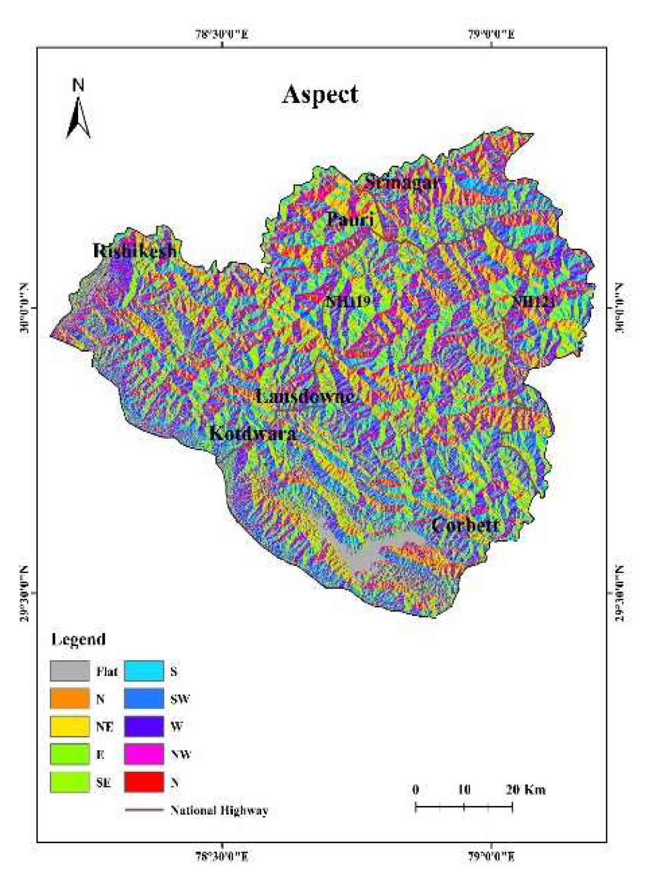
4.3. Aspect
The aspect gives the direction of the slopes. The aspect angles were categorized into 9 classes manually which are; Flat, N, NE, E, SE, S, SW, W and NW. Aspects influences factors like plant growth patterns, how temperatures change, how the wind blows, how humid it is, and how much moisture is present in the fuel (Figure 8) [1,55,56]. The pace of fuel drying and spreading of the fire are strongly correlated with aspect [48]. A site's aspect influences how much sunlight and heat it receives. Given that the chosen study region is located in the northern hemisphere, south-facing aspects receive the most solar radiation whereas north-facing aspects are the coolest [57]. Additionally, east aspects receive more direct sunshine and UV radiation throughout the day than west aspects [58].
Figure 7.
Aspect map of the region.
4.4. Land use Land cover
LULC map was obtained using Landsat 9 satellite dataset with the help of support vector machine classification with an overall accuracy of 83 percent and kappa coefficient of 0.75. The study area was classified into four classes. Information about available land cover is frequently used as a substitute for fuel (Figure 8) [59].
4.5. Lineament Density
4.6. Land Surface Temperature
Forest fires and temperature are directly related. Due to the fuels' increased flammability caused by dryness high temperatures, enhance the risk of forest fire [1,61]. Fires may ignite at any temperature, but as the temperature rises, they start to happen more frequently (Figure 10). Available fuels begin to dry up with the rising temperature, making it more prone to igniting. The destructiveness, extent, and frequency of fires are all directly impacted by rising temperatures. Also, it can be correlated that the proximity to human settlements have high temperatures due to urban heat island effects. The fires have been reported most in cases with higher temperatures than the ones having lower LST [48].
4.7. NDVI
The study area predominantly consists of Chir pine forests at higher elevations and tropical deciduous forests in the southern regions, with scattered patches of dry deciduous forests throughout the terrain. The Normalized Difference Vegetation Index (NDVI) provides insights into vegetation biomass, phenology, and photosynthesis monitoring. Higher NDVI values correspond to areas with dense vegetation that can serve as fuel for fires if vegetation health deteriorates. The southern region of the study area exhibits dense vegetation, which increases the risk of fire spread. In the upper west regions of Kotdwara, where deep-seated lineaments are present, NDVI values are significantly lower, contributing to higher fire density and maximum forest fire risk. Non-forested and barren areas display poor NDVI values, while the Ramganga lake reservoir exhibits the lowest NDVI due to the absence of vegetation cover (Figure 11) [7].
4.8. NDMI
The assessment of moisture content in crops and trees plays a crucial role in understanding the vegetation's health and susceptibility to environmental stressors, as highlighted by Wang [62]. In this context, the Normalized Difference Moisture Index (NDMI) emerges as a valuable tool for gauging the water stress levels in agricultural and forested areas, as well as identifying regions that are particularly prone to the devastating impact of forest fires [1]. By analyzing the NDMI values, we gain valuable insights into the moisture content of vegetation, allowing us to assess the level of water stress experienced by these vital ecosystems. Notably, the NH119 region exhibits a range of moderately poor NDMI values, which can serve as a prominent indicator for the potential outbreak of forest fires. Moreover, the Pauri region demonstrates persistently low NDMI values, underscoring its moderate risk of fire occurrence. Interestingly, the southern region of the study area, located below Lansdowne and in close proximity to the Corbett forests, showcases the highest NDMI values (Figure 12). However, despite the relatively healthier moisture levels, this region still poses a significant risk of moderate forest fires. This observation suggests that factors beyond moisture content, such as the topography, elevation, and human settlements, may contribute to the heightened fire risk in these areas. By leveraging the NDMI and considering multiple influencing factors, we gain a more comprehensive understanding of the interplay between moisture content, vegetation health, and the potential for forest fires in the study area. Such knowledge empowers us to implement targeted strategies and preventive measures to mitigate the risks posed by these environmental challenges.
4.9. NDWI
NDWI provides insights into the presence of water in non-vegetated areas. In our study area, the lake located in the southern part shows the highest NDWI value, indicating the presence of abundant water. However, the overall region is predominantly dry, with very low NDWI values observed throughout. Areas near human settlements also exhibit low NDWI values, suggesting limited soil moisture content in those areas. The western region of Kotdwara stands out as having the least available moisture, making it highly susceptible to fires (Figure 13). This area has been identified as the most prone to fire incidents. Similarly, the patch of Corbett forests also displays low NDWI values, indicating reduced soil moisture content. This dry soil condition increases the risk of fires, which can be easily triggered by human activities or natural causes. The high and moderate fire risk zones align closely with the NDWI output values, providing a clear connection between soil moisture and fire risk in the region. These findings highlight the importance of considering NDWI values in assessing the risk of fires and the availability of moisture in the study area. By understanding these relationships, we can better evaluate the fire risk and implement appropriate measures to prevent and manage fire incidents in the region.
4.10. Vegetation type
The type of vegetation in an area and the time it takes for vegetation to regrow after a fire play a crucial role in determining the amount of fuel present in forests. In the study area, patches of dry deciduous forests located near the southern boundary and the western region exhibit a very high risk of fire (Figure 14). These regions are characterized by vegetation that is highly susceptible to burning and may contain significant amounts of flammable material. Moist deciduous forests and subtropical pine forests represent the next level of vulnerability to fire within the study area. These vegetation types possess certain characteristics that make them more prone to fire compared to other forested areas.
On the other hand, non-forested regions, such as open grasslands or barren lands, correspond to very low fire risk zones. This finding reinforces the reliability of the results obtained, as areas without significant vegetation cover naturally have lower chances of fire occurrence. Understanding the relationship between vegetation types, their regrowth patterns, and the associated fuel loads provides valuable insights into assessing fire risks in different areas. By identifying high-risk zones based on the type of vegetation present, appropriate measures can be taken to mitigate fire hazards and protect these ecosystems.
4.11. Distance from Rivers
The proximity to surface water and the availability of soil moisture plays a crucial role in correlating fire risk in the district. The study area is characterized by a dense network of both perennial and seasonal rivers. A notable observation is the significantly lower fire density and risk near the Ramganga reservoir located in the southernmost region of Pauri (Figure 15). This can be attributed to the presence of abundant water content and moisture in the surface and atmosphere, which helps regulate the ecosystem and protect it from the stressful conditions that often lead to fires. In contrast, the western region below Rishikesh, where no rivers are nearby, exhibits a historical pattern of maximum fire density. This suggests that the absence of accessible water sources contributes to increased fire risk in this area. Similarly, the northern region near Srinagar and Pauri, which is relatively distant from river sources, also experiences higher fire risk.
The distance from rivers has proven to be a useful indicator for predicting forest fire-prone zones to some extent. However, it is important to note that seasonal rivers do not play a significant role in reducing forest fire chances during the hot and dry periods of fire seasons. This highlights the importance of considering other factors, such as soil moisture and surface water availability, in accurately assessing and managing fire risks in these regions.
4.12. Distance from roads and settlements
Human influences, such as traffic accidents and unchecked anthropogenic activities, have a significant impact on the occurrence of fires in forest environments, particularly in areas adjacent to highways and inhabited regions. Several studies have highlighted the correlation between human activities and increased fire incidents in natural ecosystems [7,59]. Notably, the forest fires exhibit a higher frequency in close proximity to settlements located along the southwestern boundary of the study area. This suggests that the presence of human habitation and associated activities contribute to a greater fire risk in these areas. Pauri and Srinagar regions, known for their higher population density and human settlements, have observed prominent occurrences of forest fires (Figure 16). On the other hand, areas located at greater distances from settlements and roads exhibit relatively lower fire risk. This highlights the significance of maintaining a considerable distance between human habitation and forested areas in order to minimize the likelihood of fire incidents.
4.13. Distance from deep seated lineaments
Lineaments serve as conduits for groundwater percolation, however lineaments arising due to tectonic disturbances can extend to great depths within the ground. Such deep seated lineaments can have totally opposite effect when comes to holding groundwater. While surface lineaments hold groundwater close to the surface, the lineaments extending to great depths can facilitate water draining straight to belowground aquifer reservoirs. This situation is even worse in the study area due to the presence of tectonic disturbances. This is further approved by the presence of ‘Mylonite’- fine grained powdery formation produced due to tectonic friction. The lineament arising at Almora-Ramgarh thrust running through the western regions of Kotdwara and Lansdowne comprises of patches of granite and quartzite (Figure 17). This formation of hard rocks coupled with the presence of lineaments drain out the available water to the deeper aquifers. This can be a possible reason of the specific location corresponding to very high forest fire incidents because the water is not available to support the vegetation. Hence, distance from lineaments were used to bring about this insightful correlation.
4.14. Forest fire density
The forest fire density map prepared from the data archive from 2001-2021 shows the uniformity of high density of forest fire at specific locations over the course of time whereas some regions remain equally less susceptible to fires throughout the years. The area near Kotdwara and Lansdowne were observed to have extreme fire density (Figure 18). All the maximum fire density locations are located near settlements as evident from the fire risk map. The fire density is significantly high at some places in alignment of NH121. The westward region of NH119 and eastern region of NH121 showed the least fire density.
4.15. Forest fire risk map
Forest Fire Risk mapping was performed for Pauri Garhwal district of Uttarakhand state. Several factors which influence forest fires were taken into account while preparing a fire risk map of the region (Figure 19). Topographic, satellite derived and historical as well as existing data was acquired with the help of remote sensing techniques and all the data was brought together and processed into same platform with the help of GIS technology. All the thematic layers were converted into same resolution and were rasterized before processing with the help of ArcGIS 10.8 software. A total five categories such as Very High-Risk, High Risk, Moderate Risk, Low Risk and Very Low Risk of an area 47.38 km2, 275.98 km2, 2374.11 km2, 985.49 km2, and 1741.17 km2 respectively.
5. Discussion
The forest fire risk zone map categorized the study area into five classes i.e., Very High Risk (47.38 km2), High Risk (275.98 km2), Moderate Risk (2374.11 km2), Low Risk (985.49 km2) and Very Low Risk (1741.17 km2) respectively. With the help of remotely sensed data and GIS techniques it was possible to map the study area into 5 different risk zones.
The fire risk map demonstrates that the forest area in the upper region of Kotdwara and the southern boundary of the district are extremely fire prone. The very high fire risk zones are located in a close proximity to human settlements. This area is geologically composed of granite and quartzite. The entire study area is tectonically active which leads to the presence of several thrusts in this area and mylonitisation of hard rocks. Owing to such factors the lineaments present are opined to drain away the available water in these hard rock formations. Hence the vegetation is not able to take benefit from the water and it infiltrates deep into the geological formations. The vegetation in this specific region is tropical dry deciduous and the area is observed to be the most prone to forest fires. The area is situated in relatively less elevated areas and lesser slope degrees. The NDVI, NDMI and NDWI values are poor in these areas.
The high-risk zones of forest fires are limited in the south and west regions and also lie within close proximity to urban settlements and corresponds to lesser elevation and poor water indexes.
The Moderate fire risk zones are near NH121, Pauri, Srinagar, near Corbett and the central region of the study area. Such regions fall under lower and middle Shivalik that are mostly composed of sandstones.
The very low and low fire risk zones can be seen at and around the water reservoir that is a lake in the south as well as the northern part of the study area having the highest elevations reaching upto 2984 m. The area on the either side of NH119 is also less fire prone which comprises of the tropical moist deciduous forests.
LST, elevation and fire risk have a linear relationship with the occurrences of forest fires and the fire risk increased with the increase in any of the factors.
The very low as well as low fire risk area in the middle of the northern and western region of the study area is not much forested as observed from the vegetation map hence the risk of forest fires is not reflected in the final fire risk map obtained.
Risk mapping can be useful for taking preventive actions in mitigating and reducing the number of hazards caused to forests by this natural disaster which continue to create havoc in the district since many years.
Supplementary Materials
No supplementary material is available to download.
Author Contributions
The contribution of research article “Conceptualization, Pardeep Kumar and Saumitra Mukherjee.; methodology, Pardeep Kumar.; software, Garima Singh and Pardeep Kumar.; validation, Saumitra Mukherjee and Pardeep Kumar.; formal analysis, Saumitra Mukherjee.; investigation, Pardeep Kumar; resources, Saumitra Mukherjee Pardeep Kumar; data curation, Garima Singh; writing—Garima Singh; writing—review and editing, Pardeep Kumar and Saumitra Mukherjee; visualization, Saumitra Mukherjee.; supervision, Saumitra Mukherjee. All authors have read and agreed to the published version of the manuscript.”
Funding
This research received no external funding.
Data Availability Statement
Raw data will be available on request.
Conflicts of Interest
The authors declare no conflict of interest.
References
- Tiwari, A., Shoab, M., & Dixit, A. GIS-based Forest fire susceptibility modeling in Pauri Garhwal, India: a comparative assessment of frequency ratio, analytic hierarchy process and fuzzy modeling techniques. Natural hazards (2021), 105, 1189-1230. [CrossRef]
- Jaiswal, R. K., Mukherjee, S., Raju, K. D., & Saxena, R. Forest fire risk zone mapping from satellite imagery and GIS. International journal of applied earth observation and geoinformation (2002), 4(1), 1-10.
- India State of Forest Report. Ministry of Environment and Forest, Dehradun, India (2011).
- Mukherjee, S., & Raj, K. Analysis of forest fire of Meghalaya using geospatial tools. In 15th ESRI India user conference (2014).
- Chuvieco, E., & Congalton, R. G. Application of remote sensing and geographic information systems to forest fire hazard mapping. Remote sensing of Environment (1989), 29(2), 147-159. [CrossRef]
- Hantson, S., Pueyo, S., & Chuvieco, E. Global fire size distribution: from power law to log-normal. International journal of wildland fire (2016), 25(4), 403-412. [CrossRef]
- Mohajane, M., Essahlaoui, A., Oudija, F., Hafyani, M. E., Hmaidi, A. E., Ouali, A. E., ... & Teodoro, A. C. (2018). Land use/land cover (LULC) using landsat data series (MSS, TM, ETM+ and OLI) in Azrou Forest, in the Central Middle Atlas of Morocco. Environments, 5(12), 131.
- Zema, D. A., Nunes, J. P., & Lucas-Borja, M. E. Improvement of seasonal runoff and soil loss predictions by the MMF (Morgan-Morgan-Finney) model after wildfire and soil treatment in Mediterranean forest ecosystems. Catena (2020), 188, 104415. [CrossRef]
- Pyne, S. J., Andrews, P. L., & Laven, R. D. (1996). Introduction to Wildland Fire, John Wiley and Sons. New York.
- Saha, S., & Howe, H. F. Species composition and fire in a dry deciduous forest. Ecology (2003), 84(12), 3118-3123. [CrossRef]
- Negi, G. C. S. Forest fire in Uttarakhand: causes, consequences and remedial measures. International Journal of Ecology and Environmental Sciences (2019), 45(1), 31-37.
- Hoffmann, A. A., Siegert, F., & Hinrichs, A. Fire damage in East Kalimantan in 1997/98 related to land use and vegetation classes: satellite radar inventory results and proposals for further actions (1999) (p. 26). IFFM/SFMP.
- Potter, L., & Lee, J. Oil palm in Indonesia: its role in forest conversion and the fires of 1997/1998. Report to the WWF, Indonesia Programme, Jakarta (1998).
- Dennis, R. A., Mayer, J., Applegate, G., Chokkalingam, U., Colfer, C. J. P., Kurniawan, I., & Tomich, T. P. Fire, people and pixels: linking social science and remote sensing to understand underlying causes and impacts of fires in Indonesia. Human Ecology (2005), 33, 465-504. [CrossRef]
- Alkhatib, A. A. A review on forest fire detection techniques. International Journal of Distributed Sensor Networks (2014), 10(3), 597368.
- Giglio, L., Van der Werf, G. R., Randerson, J. T., Collatz, G. J., & Kasibhatla, P.. Global estimation of burned area using MODIS active fire observations. Atmospheric Chemistry and Physics (2006), 6(4), 957-974. [CrossRef]
- Parajuli, A., Gautam, A. P., Sharma, S. P., Bhujel, K. B., Sharma, G., Thapa, P. B., ... & Poudel, S. Forest fire risk mapping using GIS and remote sensing in two major landscapes of Nepal. Geomatics, Natural Hazards and Risk (2020), 11(1), 2569-2586. [CrossRef]
- Randerson, J. T., Liu, H., Flanner, M. G., Chambers, S. D., Jin, Y., Hess, P. G., ... & Zender, C. S. The impact of boreal forest fire on climate warming. science (2006), 314(5802), 1130-1132. [CrossRef]
- Negi, M. S., & Kumar, A. Assessment of increasing threat of forest fires in Uttarakhand, using remote sensing and GIS techniques. Global Journal of Advanced Research (2016), 3(6), 457-468.
- Goldammer, J. G. (Ed.). Fire in the tropical biota: Ecosystem processes and global challenges (2012), (Vol. 84). Springer Science & Business Media.
- Cochrane, M. A., & Laurance, W. F. Fire as a large-scale edge effect in Amazonian forests. Journal of Tropical Ecology (2002), 18(3), 311-325. [CrossRef]
- Renard, Q., Pélissier, R., Ramesh, B. R., & Kodandapani, N. Environmental susceptibility model for predicting forest fire occurrence in the Western Ghats of India. International Journal of Wildland Fire (2012), 21(4), 368-379. [CrossRef]
- Sowmya, S. V., & Somashekar, R. K. Application of remote sensing and geographical information system in mapping forest fire risk zone at Bhadra wildlife sanctuary, India. Journal of Environmental Biology (2010), 31(6), 969.
- Kandya, A. K., Kimothi, M. M., Jadhav, R. N., & Agarwal, J. P. Application of Geographic Information System in Identification of'Fire-Prone'Areas: A Feasibility Study in Parts of Junagadh (Gujarat). Indian Forester (1998), 124(7), 531-536.
- India State of Forest Report (ISFR). Forest Survey of India, https://fsi.nic.in/forest-report-2019, (2021).
- Champion, H. G., & Seth, S. K. A revised survey of the forest types of India. Manager of publications (1968).
- Babu KV, S., Roy, A., & Prasad, P. R. Forest fire risk modeling in Uttarakhand Himalaya using TERRA satellite datasets. European Journal of Remote Sensing (2016), 49(1), 381-395.
- Pandey, K., & Ghosh, S. K. Modeling of parameters for forest fire risk zone mapping. The International Archives of Photogrammetry, Remote Sensing and Spatial Information Sciences (2018), 42, 299-304. [CrossRef]
- Pham, B. T., Khosravi, K., & Prakash, I. Application and comparison of decision tree-based machine learning methods in landside susceptibility assessment at Pauri Garhwal Area, Uttarakhand, India. Environmental Processes (2017), 4(3), 711-730. [CrossRef]
- Gaur, R. D., & Bartwal, B. S. DIFFERENT TYPES OF FOREST COMMUNITIES IN PAURI DISTRICT. Garhwal Himalaya: ecology and environment (1993), 131.
- Dobhal, G. L. Development of the hill areas: a case study of pauri garhwal district. Concept Publishing Company (2005).
- Sharma, C. M., Baduni, N. P., Gairola, S., Ghildiyal, S. K., & Suyal, S. (2010). Tree diversity and carbon stocks of some major forest types of Garhwal Himalaya, India. Forest Ecology and Management, 260(12), 2170-2179. [CrossRef]
- Rawat, A., Banerjee, S., Sundriyal, Y., & Rana, V. An integrated assessment of the geomorphic evolution of the Garhwal synform: Implications for the relative tectonic activity in the southern part of the Garhwal Himalaya. Journal of Earth System Science (2022), 131(1), 56. [CrossRef]
- Valdiya, K. S. Geology of kumaun lesser Himalaya (Vol. 291). Dehradun: Wadia Institute of Himalayan Geology (1980).
- Auden, J. B. Structure of the Himalaya in Garhwal. Records Geological Survey of India (1937), 71, 407-433.
- Gupta, L. N. Abnormal tectonics of the allochthonous Lansdowne granite and the tectonic history of Garhwal nappe. Indian Mineral (1976), 17, 73-85.
- Kumar, U., Kumar, B., & Mallick, N. Groundwater prospects zonation based on RS and GIS using fuzzy algebra in Khoh River watershed, Pauri-Garhwal District, Uttarakhand, India. Global Perspectives on Geography (GPG) (2013), 1(3), 37-45.
- Krishnamurthy, J., & Srinivas, G. Role of geological and geomorphological factors in ground water exploration: a study using IRS LISS data. International Journal of Remote Sensing (1995), 16(14), 2595-2618. [CrossRef]
- Rajendran, C. P., Sanwal, J., John, B., Anandasabari, K., Rajendran, K., Kumar, P., ... & Chopra, S. Footprints of an elusive mid-14th century earthquake in the central Himalaya: Consilience of evidence from Nepal and India. Geological Journal (2019), 54(5), 2829-2846. [CrossRef]
- Rajendran, C. P., Singh, T. E. J. P. A. L., Mukul, M. A. L. A. Y., Thakkar, M. A. H. E. S. H., Kothyari, G. C., John, B., & Rajendran, K. Paleoseismological studies in India (2016-2020): status and prospects. In Proc Indian Natn Sci Acad (2020, March), (Vol. 86, No. 1, pp. 585-607). [CrossRef]
- Thakur, M., Singh, G., & Malik, J. N. Geological and geomorphic evidences of neotectonic activity along the Himalayan Frontal Thrust, Nahan Salient, NW Himalaya, India. Quaternary International (2021), 575, 5-20. [CrossRef]
- O'leary, D. W., Friedman, J. D., & Pohn, H. A. Lineament, linear, lineation: some proposed new standards for old terms. Geological Society of America Bulletin (1976), 87(10), 1463-1469.
- Moore, G. K., & Waltz, F. A. Objective procedures for lineament enhancement and extraction. Photogrammetric Engineering and remote sensing (1983), 49(5), 641-647.
- Erten, E., Kurgun, V., & Musaoglu, N. Forest fire risk zone mapping from satellite imagery and GIS: a case study. In XXth Congress of the International Society for Photogrammetry and Remote Sensing, Istanbul, Turkey (2004, July), (pp. 222-230).
- Avdan, U., & Jovanovska, G. Algorithm for automated mapping of land surface temperature using LANDSAT 8 satellite data. Journal of sensors (2016), 2016, 1-8. [CrossRef]
- McFeeters, S. K. The use of the Normalized Difference Water Index (NDWI) in the delineation of open water features. International journal of remote sensing (1996), 17(7), 1425-1432. [CrossRef]
- Buechling, A., & Baker, W. L. A fire history from tree rings in a high-elevation forest of Rocky Mountain National Park. Canadian Journal of Forest Research (2004), 34(6), 1259-1273. [CrossRef]
- Chuvieco, E., & Congalton, R. G. Mapping and inventory of forest fires from digital processing of TM data. Geocarto International (1988), 3(4), 41-53. [CrossRef]
- Gaither, C. J., Poudyal, N. C., Goodrick, S., Bowker, J. M., Malone, S., & Gan, J. Wildland fire risk and social vulnerability in the Southeastern United States: An exploratory spatial data analysis approach. Forest policy and economics (2011), 13(1), 24-36. [CrossRef]
- Falkowski, M. J., Gessler, P. E., Morgan, P., Hudak, A. T., & Smith, A. M. Characterizing and mapping forest fire fuels using ASTER imagery and gradient modeling. Forest ecology and management (2005), 217(2-3), 129-146. [CrossRef]
- Viegas, D. X. Slope and wind effects on fire propagation. International Journal of Wildland Fire (2004), 13(2), 143-156.
- Mermoz, M., Kitzberger, T., & Veblen, T. T. Landscape influences on occurrence and spread of wildfires in Patagonian forests and shrublands. Ecology (2005), 86(10), 2705-2715. [CrossRef]
- Minnich, R. A. THE GEOGRAPHY OF FIRE AND CONIFER FORESTS IN THE EASTERN TRANSVERSE RANGES, CALIFORNIA. University of California, Los Angeles (1978).
- Van Wagner, C. E. Effect of slope on fires spreading downhill. Canadian journal of forest research (1988) (Print), 18(6), 818-820.
- Pourtaghi, Z. S., Pourghasemi, H. R., & Rossi, M. (2015). Forest fire susceptibility mapping in the Minudasht forests, Golestan province, Iran. Environmental Earth Sciences, 73(4), 1515-1533. [CrossRef]
- Iwan, R., Limberg, G., Moeliono, M., Sudana, M., & Wollenberg, E. Mobilizing community conservation: a community initiative to protect its forest against logging in Indonesia. In Xth Meeting of the International Association for the Study of Common Property (2004, August) (pp. 9-13).
- Hayes, G. L. Influence of altitude and aspect on daily variations in factors of forest-fire danger (No. 591). US Department of Agriculture (1941).
- Beaty, R. M., & Taylor, A. H. Spatial and temporal variation of fire regimes in a mixed conifer forest landscape, Southern Cascades, California, USA. Journal of Biogeography (2001), 28(8), 955-966. [CrossRef]
- Tien Bui, D., Le, K. T. T., Nguyen, V. C., Le, H. D., & Revhaug, I. Tropical Forest fire susceptibility mapping at the Cat Ba National Park Area, Hai Phong City, Vietnam, using GIS-based kernel logistic regression. Remote Sensing (2016), 8(4), 347.
- Mukherjee, S. Role of satellite sensors in groundwater exploration. Sensors (2008), 8(3), 2006-2016. [CrossRef]
- Flannigan, M. D., Wotton, B. M., Marshall, G. A., De Groot, W. J., Johnston, J., Jurko, N., & Cantin, A. S. Fuel moisture sensitivity to temperature and precipitation: climate change implications. Climatic Change (2016), 134, 59-71. [CrossRef]
- Wang, L., Hunt Jr, E. R., Qu, J. J., Hao, X., & Daughtry, C. S. Remote sensing of fuel moisture content from ratios of narrow-band vegetation water and dry-matter indices. Remote Sensing of Environment (2013), 129, 103-110.
Figure 1.
Location map of Pauri-Gharwal region.
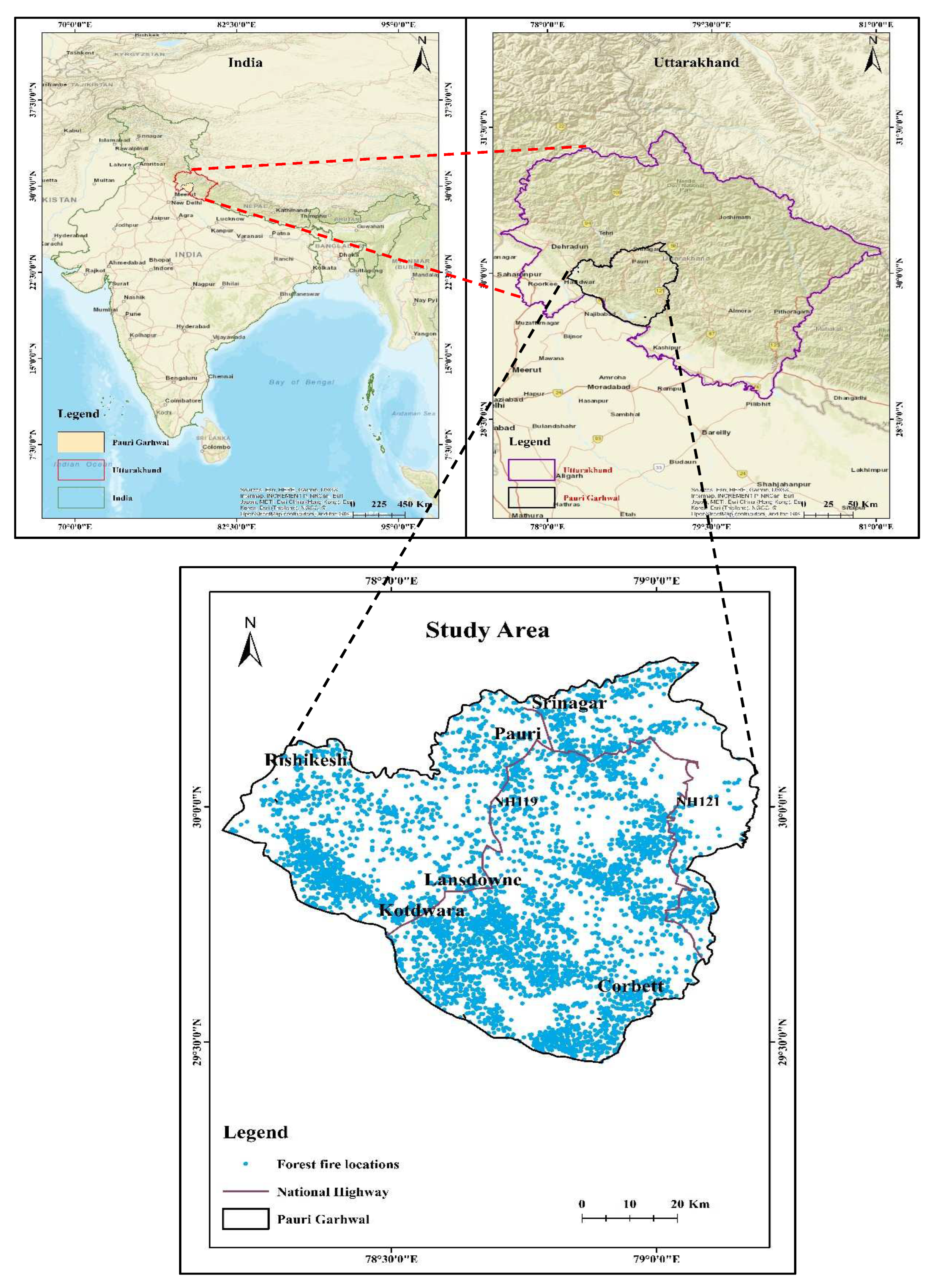
Figure 2.
(a) Geology and (b) Geomorphology map of the region.
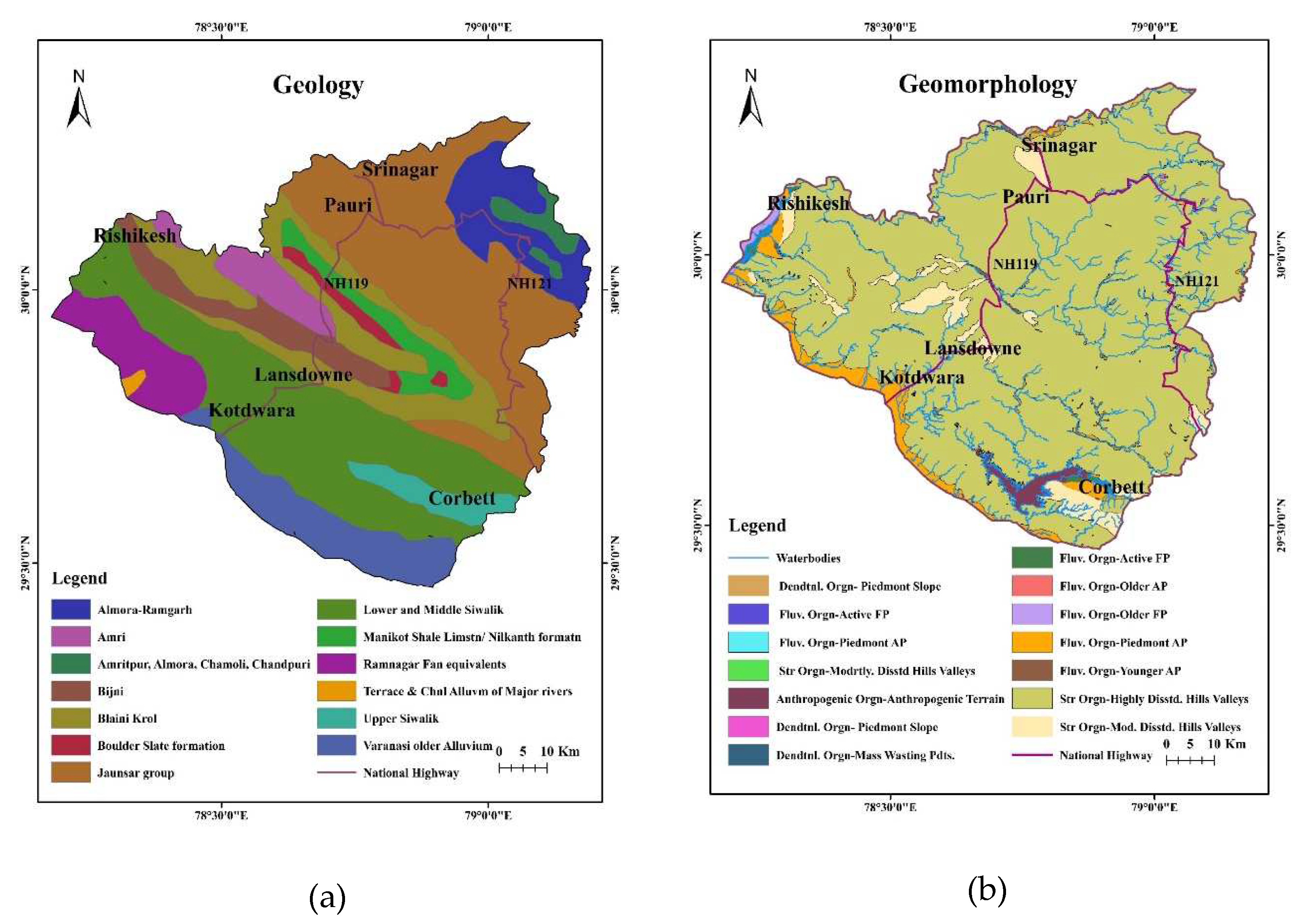
Figure 3.
Surface lineament map of the region.
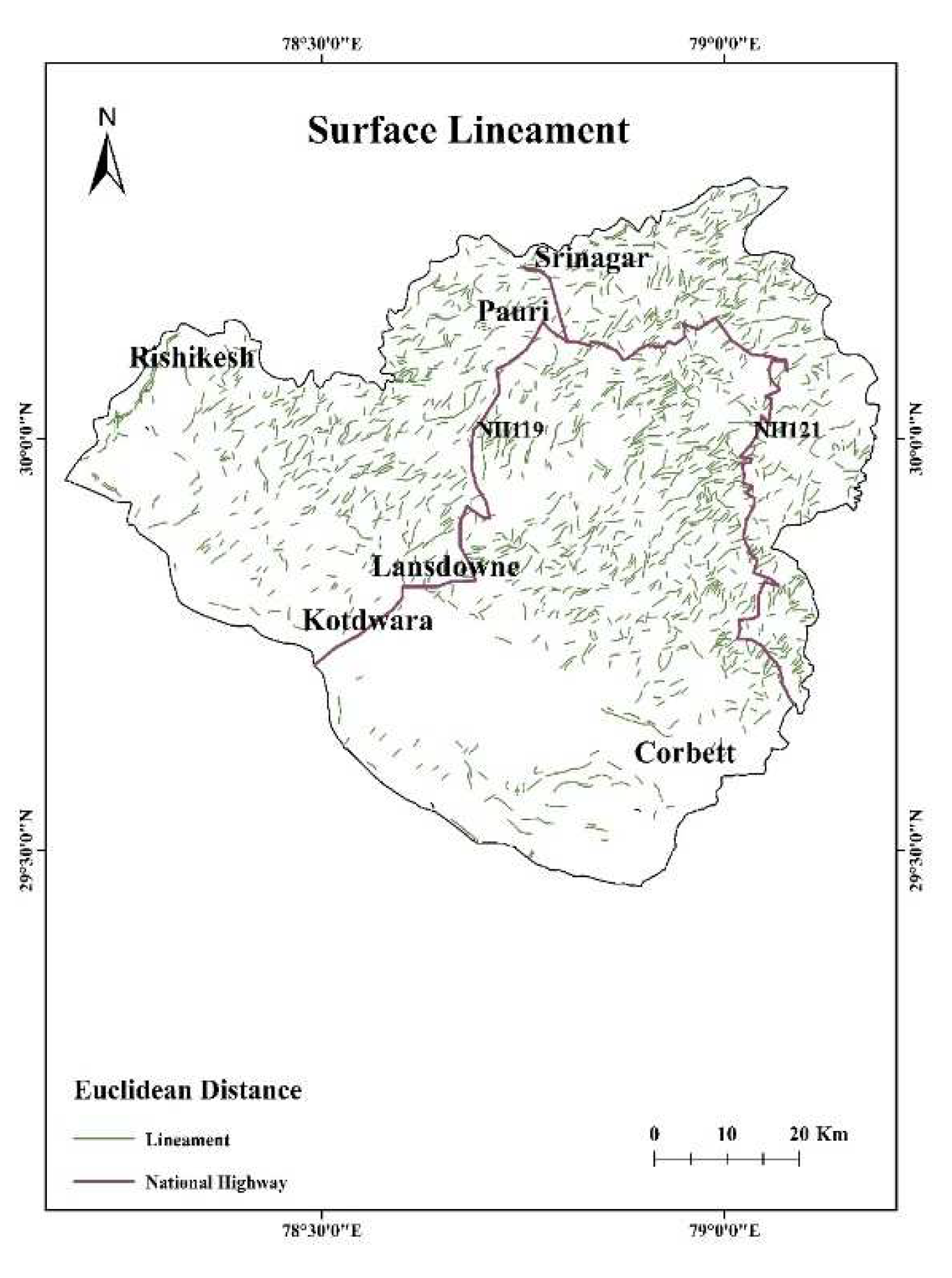
Figure 4.
Flow chart of research work.
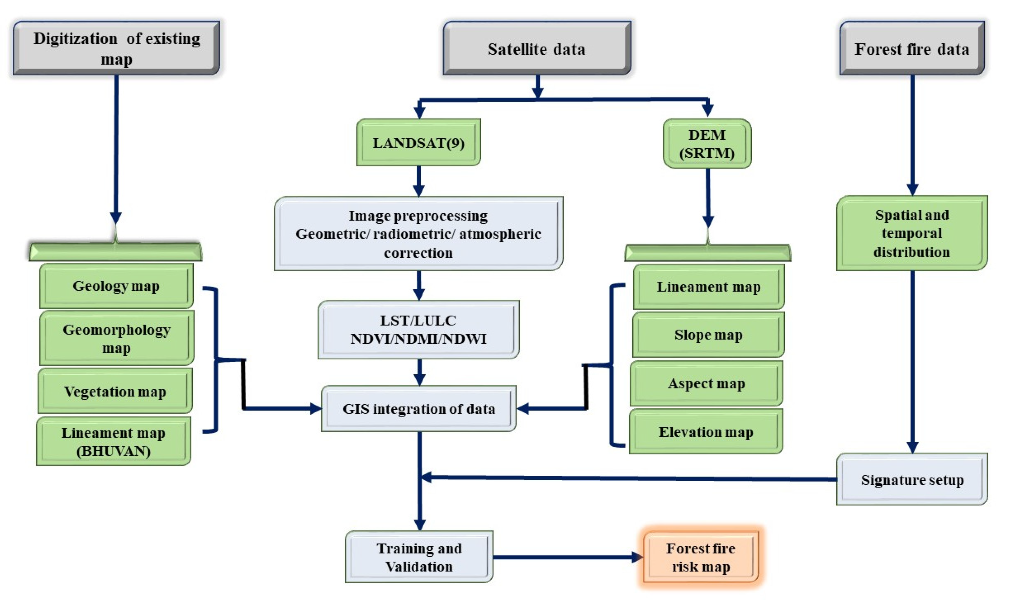
Figure 5.
LST calculation algorithm flowchart.
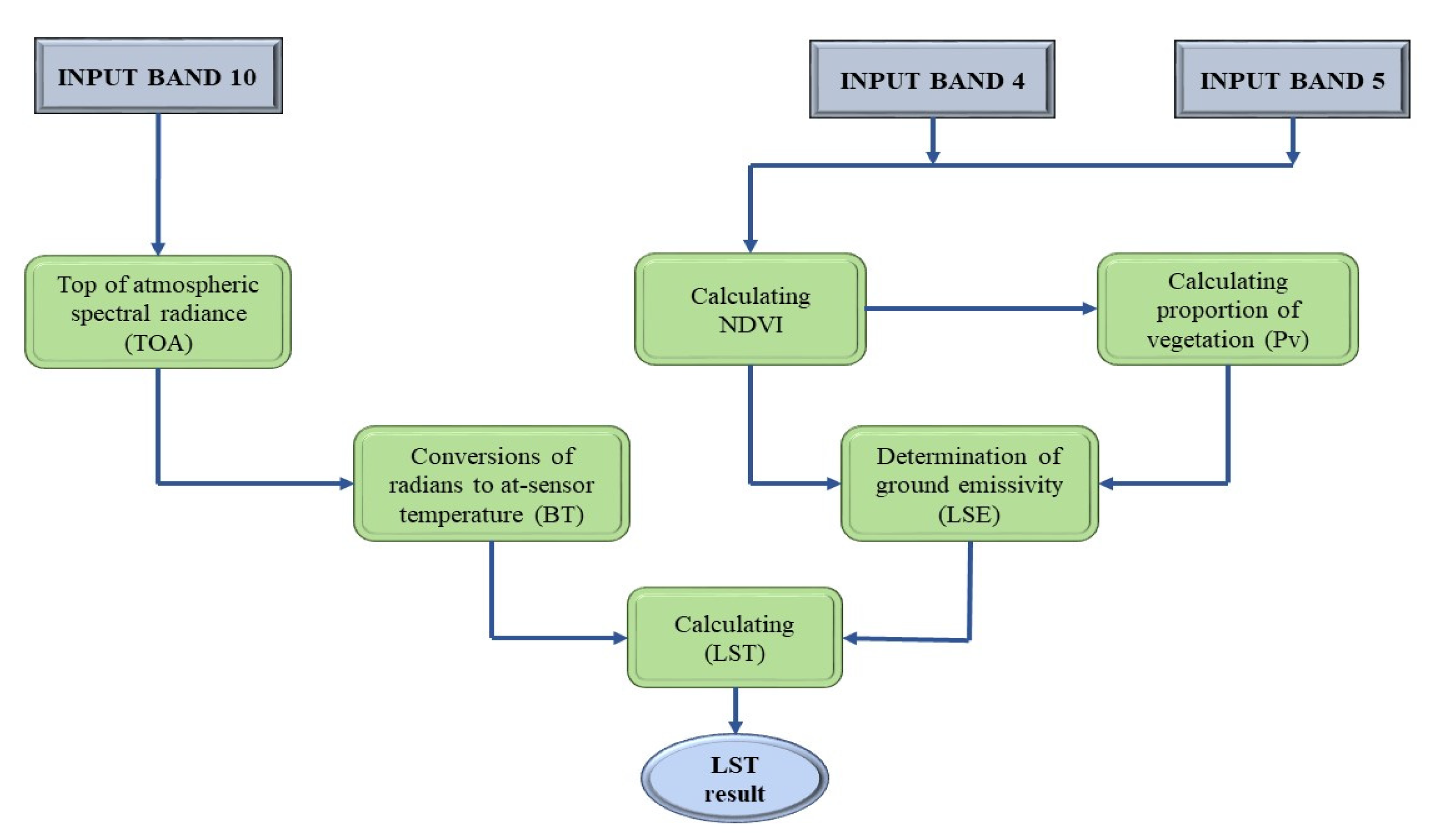
Figure 6.
Elevation map of the region.
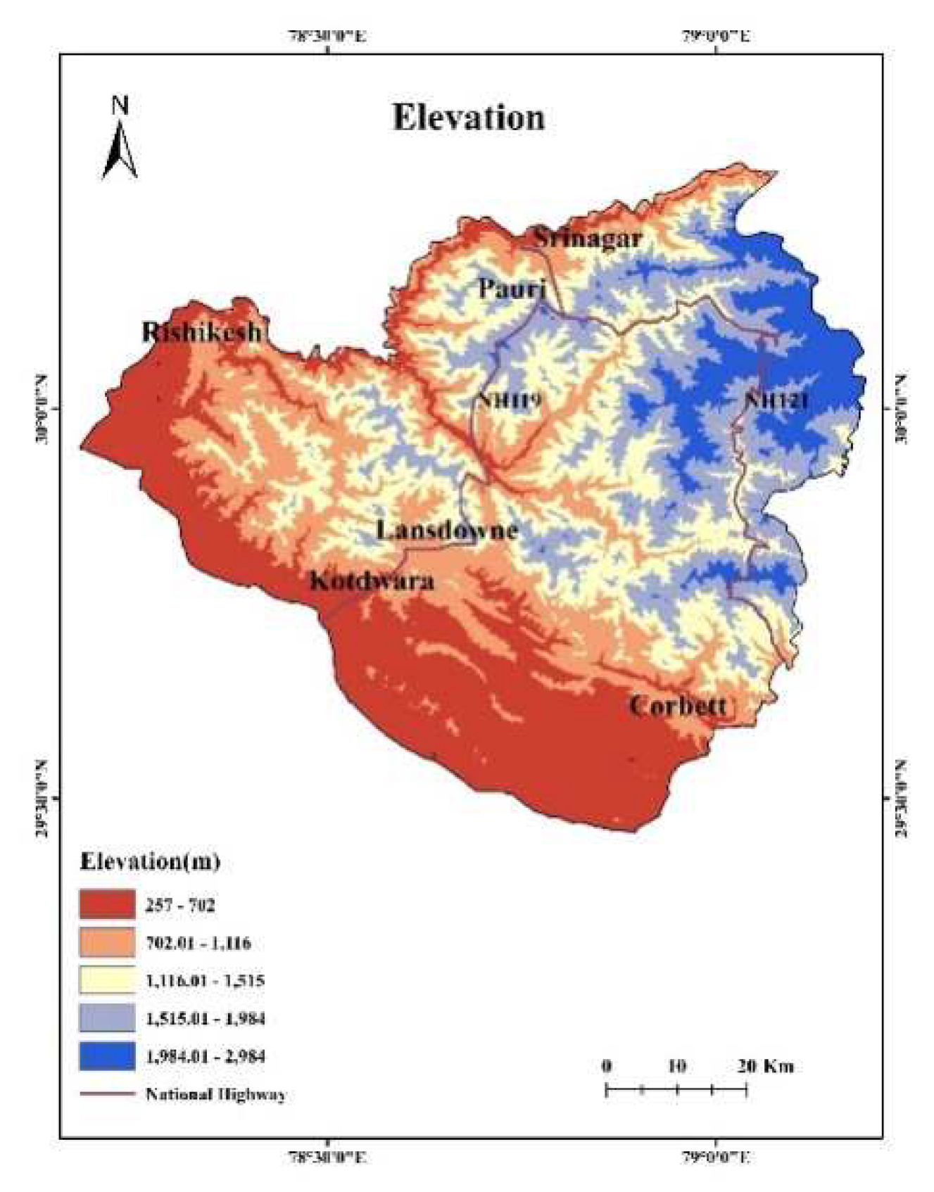
Figure 7.
Slope map of the region.
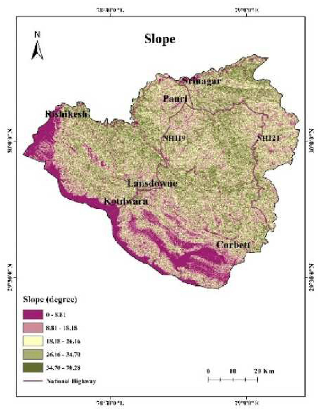
Figure 8.
LULC map of the region.
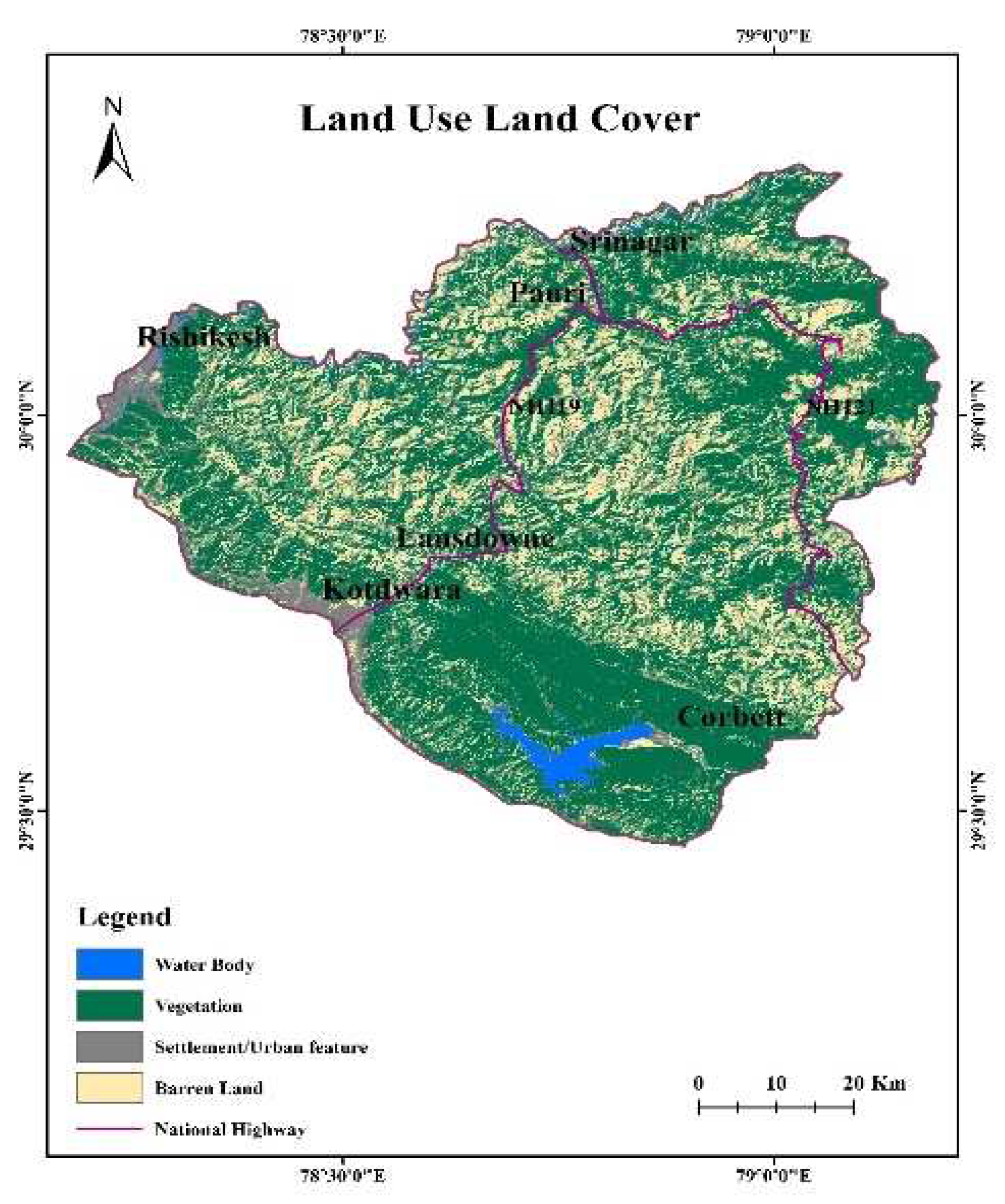
Figure 9.
Surface lineament density map of the region.
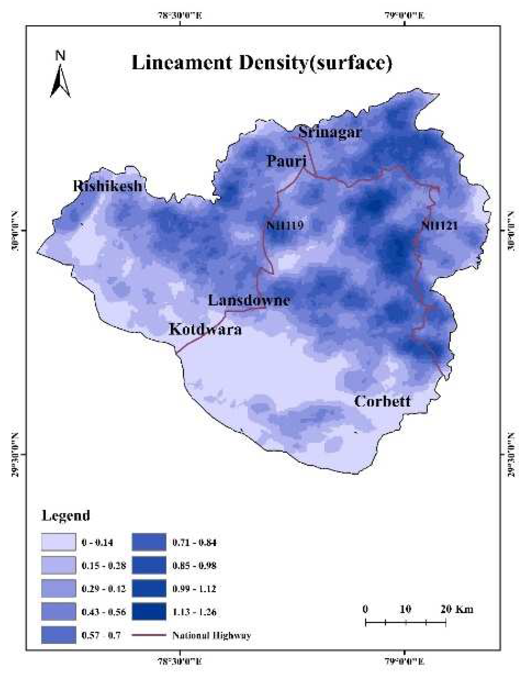
Figure 10.
LST map of the region.
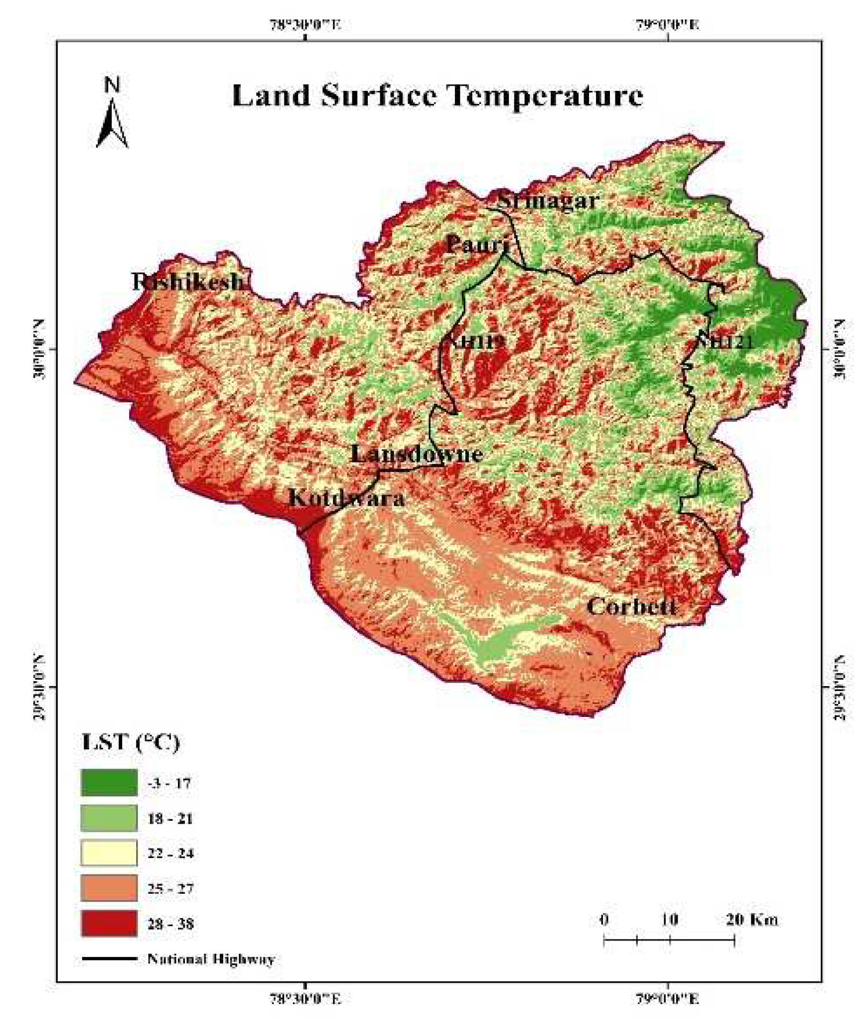
Figure 11.
NDVI map of the region.
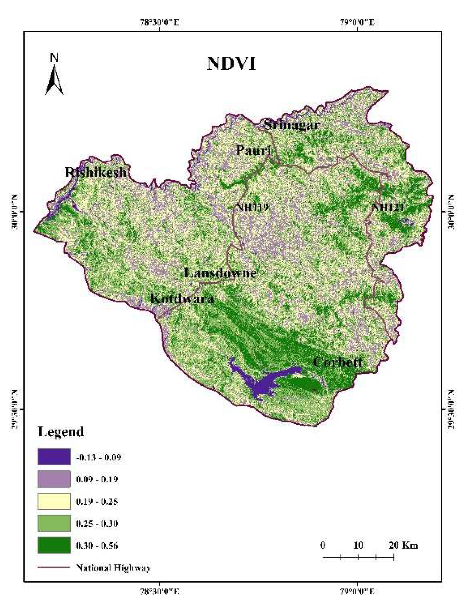
Figure 12.
NDMI map of the region.
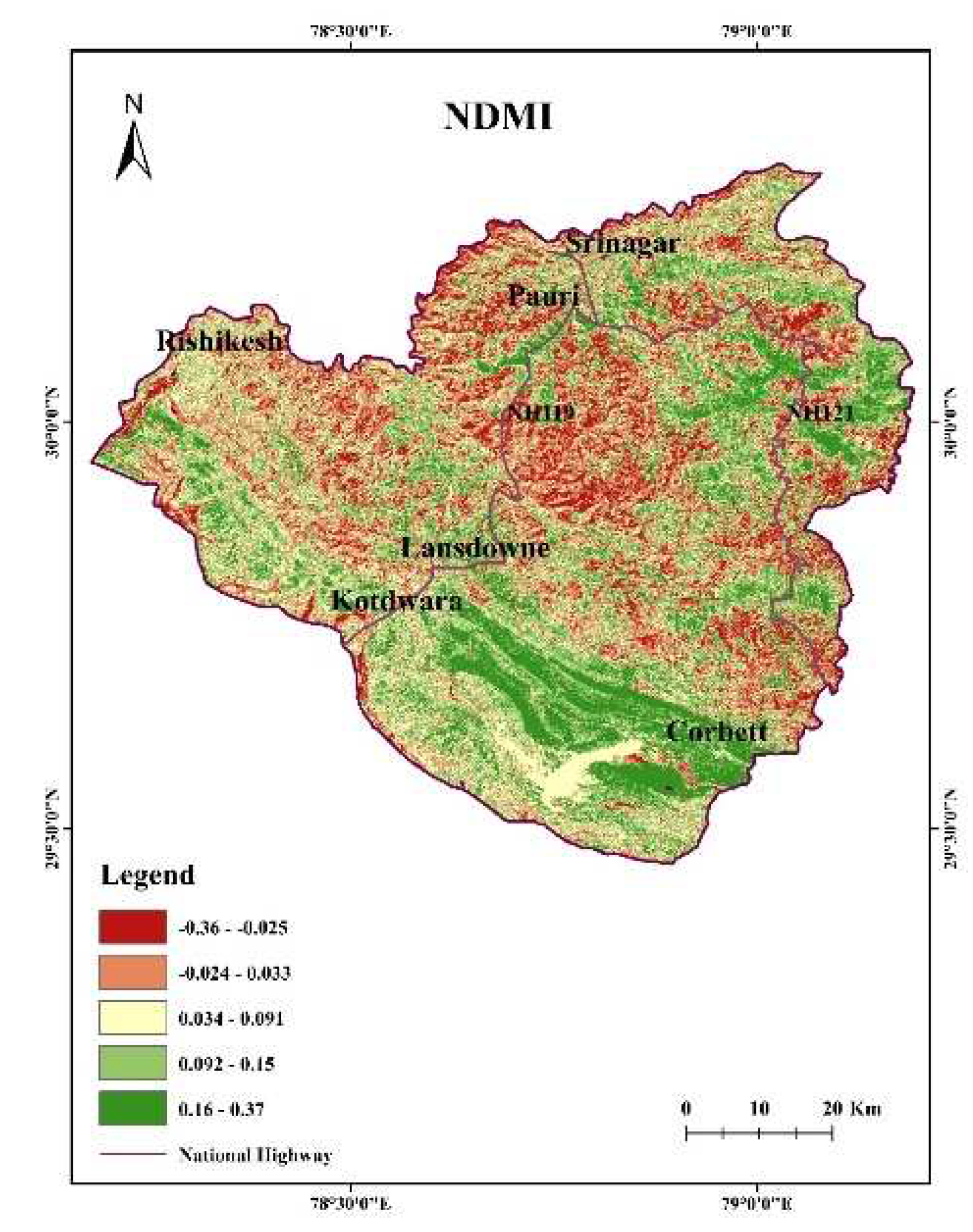
Figure 13.
NDWI map of the region.
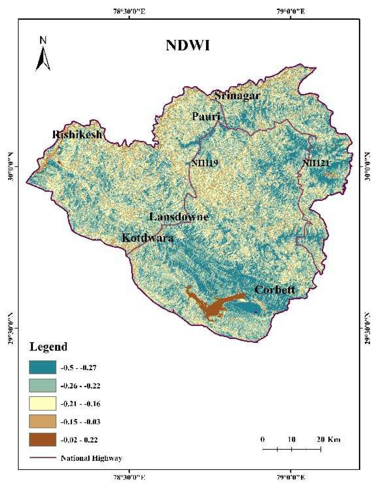
Figure 14.
Vegetation map of the region.
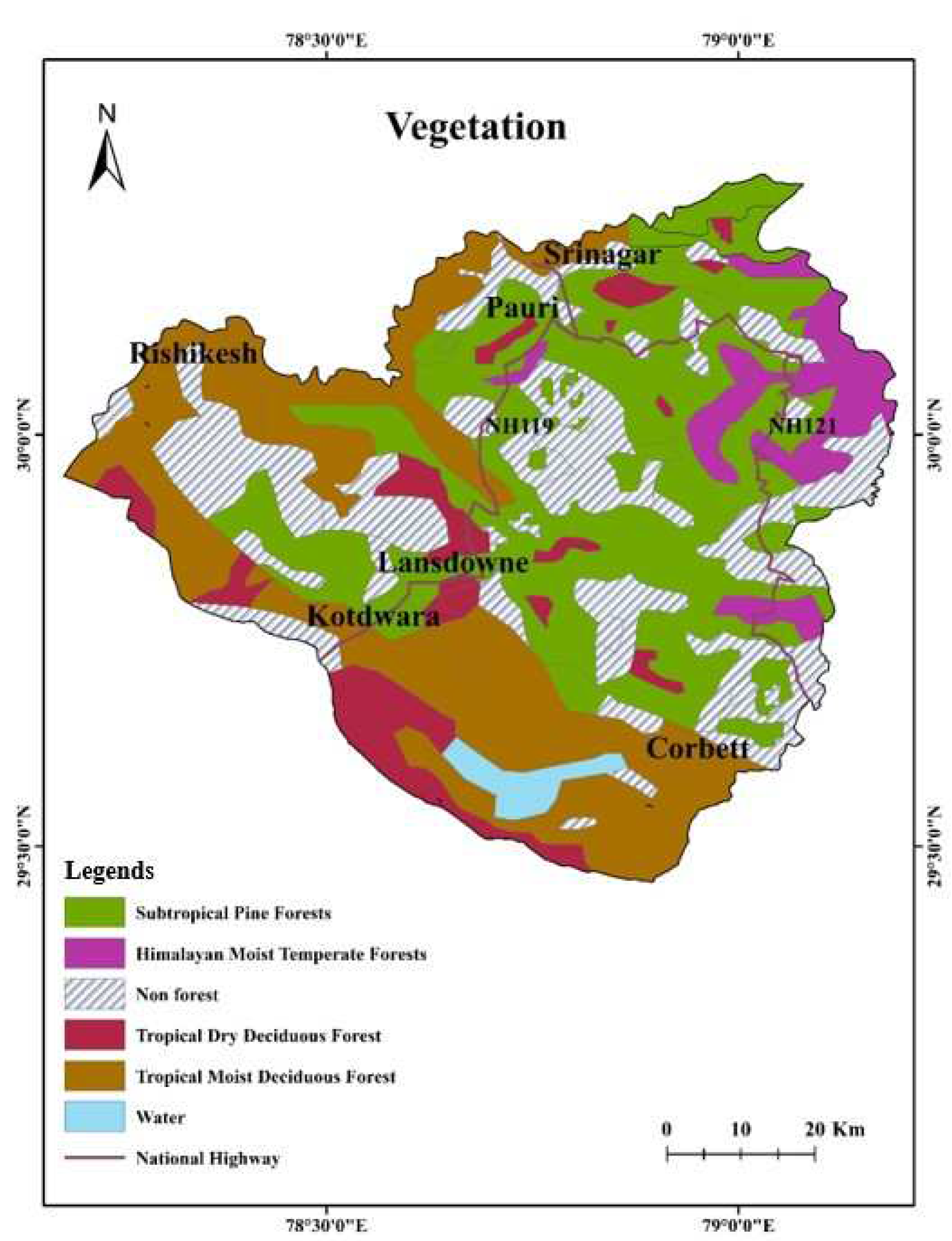
Figure 15.
Euclidean distance from river map of the region
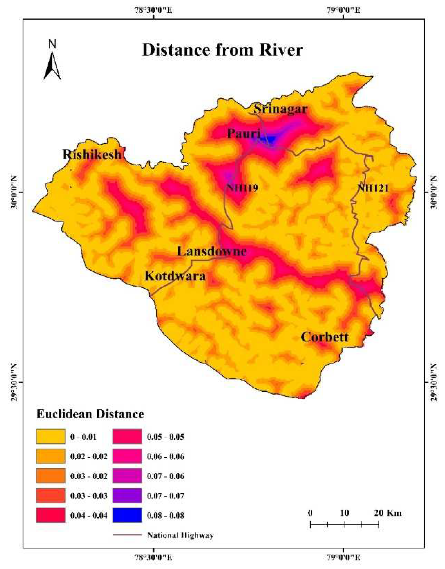
Figure 16.
Euclidean distance from road and settlement map of the region
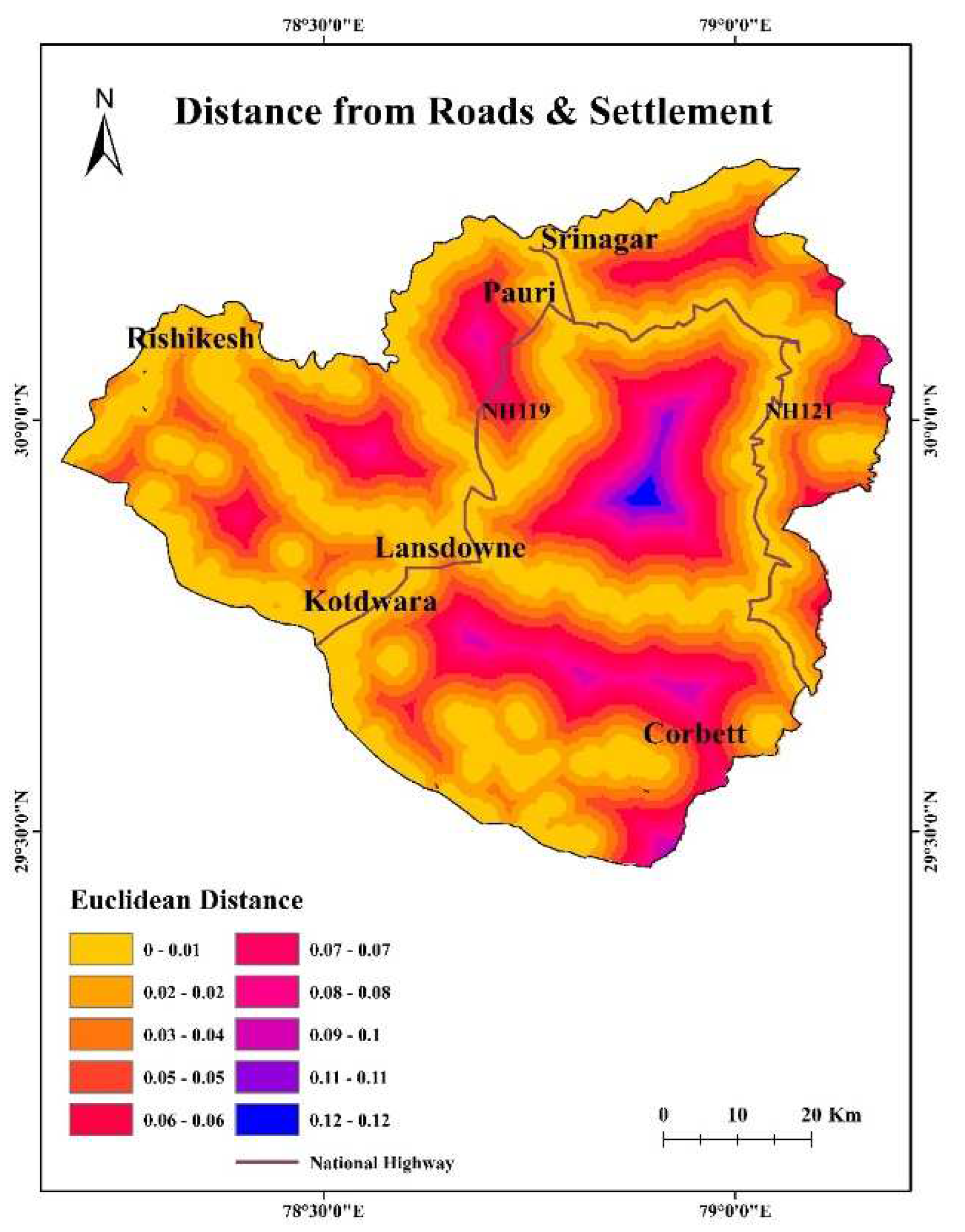
Figure 17.
Euclidean distance from lineament map of the region
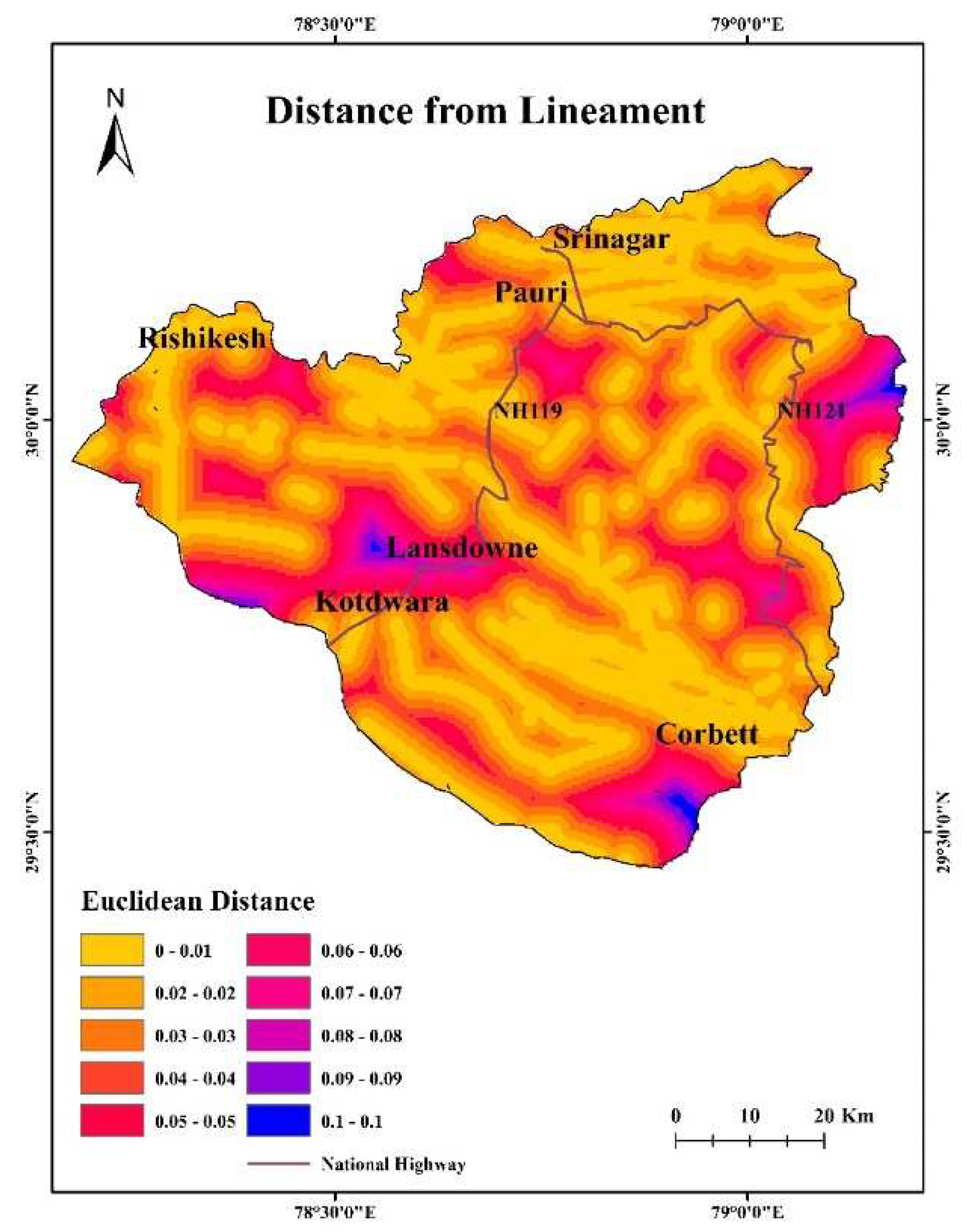
Figure 18.
Forest fire density map of the region
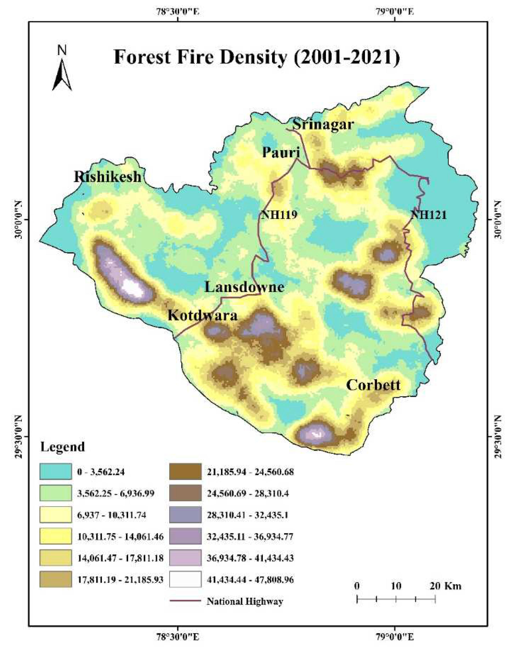
Figure 19.
Forest fire risk zone map of the region
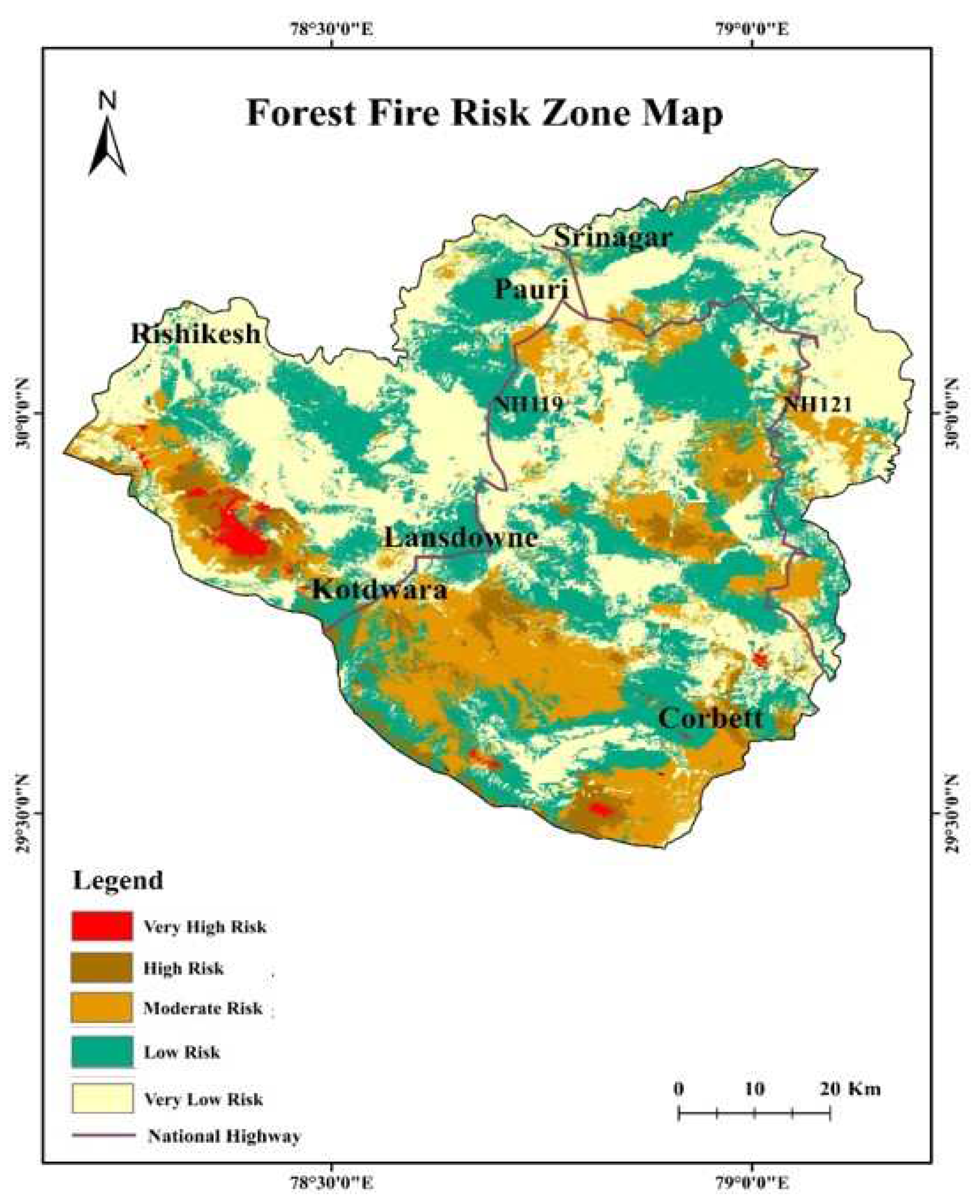

Table 1.
Forest Cover of Uttarakhand.
| Class | Area (km2) |
Geographic area (%) |
| Very Dense Forest | 5,046.76 | 9.44 |
| Moderately Dense Forest | 12,805.24 | 23.94 |
| Open Forest | 6,451.04 | 12.06 |
| Total | 24,303.04 | 45.44 |
Disclaimer/Publisher’s Note: The statements, opinions and data contained in all publications are solely those of the individual author(s) and contributor(s) and not of MDPI and/or the editor(s). MDPI and/or the editor(s) disclaim responsibility for any injury to people or property resulting from any ideas, methods, instructions or products referred to in the content. |
© 2023 by the authors. Licensee MDPI, Basel, Switzerland. This article is an open access article distributed under the terms and conditions of the Creative Commons Attribution (CC BY) license (http://creativecommons.org/licenses/by/4.0/).
Copyright: This open access article is published under a Creative Commons CC BY 4.0 license, which permit the free download, distribution, and reuse, provided that the author and preprint are cited in any reuse.


