
Submitted:
21 June 2023
Posted:
21 June 2023
You are already at the latest version
Abstract
Land use is an embodiment of human socioeconomic activities and represents a bridge between these activities and natural systems. Through social activities, humans transform land use to promote social and economic development and improve production, living conditions, and eco-logical functions of land. Rural residential land represents a space for rural residents to reside in and exhibits spatial characteristics that evolve over time, which is proof of rural socioeconomic development. This paper observes rural residential land in 21 cities on the Grand Canal and analyses its spatial differentiation. Then, it explores the driving factors of this land using spatial grid analysis and the geographic detector model. Lastly, it proposes three different forms of rural residential land based on the results. The study found that: (1) the change of rural residential land in the northern part of the Grand Canal was more volatile than that in the southern part. The change of rural residential land from 1990 to 2020 conformed to the pattern of cultivated land - rural residential land - urban construction land; (2) Based on the driving factors of rural residen-tial land, the land is divided into one-dimensional cities, two-dimensional cities and three-dimensional cities. Circular, linear, and scattered cities of different sizes were affected by socioeconomic factors, transportation accessibility, and the natural environment, respectively; and (3) Finally, according to the spatial differentiation characteristics and the driving factors of rural residential land, the study proposes the construction of three types of villages through the strate-gies of constructing large-scale villages, relocating and reconstructing new villages, and con-structing high-quality villages, respectively. Enhancing the scientific planning of rural residential land and its efficiency can offer the protection of agricultural land and the integration of urban and rural areas in the new era.
Keywords:
Grand Canal
; rural residential land
; remote sensing data
; driving factors
1. Introduction
Villages are important rural settlements in which rural residents should live for a long time. They are also the main areas of agricultural production. Due to rapid urbanisation and industrialisation, the population in China has significantly increased and a large number of rural residents moved to urban areas. Nevertheless, the rural population first increased and then decreased. From 1991 to 2022, it decreased from 905 million to 491 million [1]. With the growing demand for urban land, rural residential areas are being converted to urban construction land, while rural residential land is replaced by agricultural land. In recent years, however, there has been an increase in the number of rural residents migrating to urban areas, resulting in a further increase in the ageing population in the rural areas [2]. Thus, a large number of rural residential land has been abandoned, resulting in a decrease in land use efficiency [3,4]. The introduction of policies such as ‘Merging Villages and Towns’ and ‘New Urbanisation’ has led to the demolition of a large number of rural homesteads [5,6], which have been turned into urban construction land or reclaimed as farmland, resulting in significant changes in rural residential land. Nonetheless, the need for rehoming individuals from occupied villages has led to an increase in land use in new rural settlements due to the implementation of adjacent resettlement [7,8]. Thus, rural settlements have undergone dynamic changes in time and space, which have had a significant impact on the socioeconomic development of cities. Based on the research on the spatial differentiation and change of rural residential land, it is important to explore the driving factors of rural residential land to improve land use efficiency in spatial planning.
Domestic and international research on rural residential land has reached a mature stage. It includes research on the spatial differentiation and change of rural residential areas [9,10], the spatiotemporal relationship between and transformation of rural and urban construction land [11,12], and the impact of rural residential areas on social economy [13]. The methods include remote sensing and spatial analysis technology (ArcGIS), while the research scope involves different villages, towns, counties, cities, provinces, and countries [14,15,16,17,18]. The characteristics of rural residential land change vary significantly among different administrative units due to different driving factors. Relying on the research on the driving factors of urban construction land, scholars have divided the driving factors of rural residential land into socioeconomic factors, transportation accessibility factors, and natural environmental factors [19,20]. In particular, the level of socioeconomic development has affected the size of rural residential land, especially in the economically developed eastern coastal areas where the growth rate of rural residential land is much higher than that in the western regions [21]. The rapid expansion of rural residential land near the city is more prominent than that in remote mountainous areas. Transportation accessibility mainly includes railways, motorways, and major rivers. These transportation arteries provide conveniences for farmers, especially for the development of agricultural production. Thus, most rural residential areas have a linear distribution that relies on main transportation arteries and rivers [22]. Natural environmental factors affect the distribution of rural residential land. This is why areas with flat terrain and relatively low elevation should become rural residential areas and not those with frequent earthquakes, volcanic eruptions, and mudslides. Thus, the density of rural residential land in the plains is much higher than that on plateaus and mountains [23]. The density of rural residential areas and their land use changes are influenced by various driving factors. Methods to analyse the driving factors of rural residential land include regression analysis, which detects the temporal factors of change in rural residential land, and geographic weighted regression and geographic detectors, which detect the spatial factors of the change in rural residential land [24,25]. The research data of rural residential areas constitute spatial vector points and land grid data. To systematically analyse the spatial differentiation of the rural residential land, the rural residential land in different administrative units is converted to grid data with uniform resolution by means of kernel density analysis or grid scale conversion. In particular, the GIS spatial analysis method provides reliable technical support for the spatiotemporal analysis of rural residential land [26,27].
As the number of emptied and abandoned rural homestead rises, the Chinese government began to strictly supervise rural homesteads. The newly revised ‘Land Management Law of the People’s Republic of China’ in 2022 stipulates that rural villagers can own one homestead per household and that the villagers should use the abandoned homestead and land in the village for residential construction. This also indicates that most county and district governments will no longer approve the addition of new rural homesteads. Thus, it is important to understand the size and dynamic transformation of abandoned rural homesteads and analyse the spatiotemporal changes of rural residential land and its relationship with different factors to optimise the rural residential land layout.
The Grand Canal in China is an important watershed that connects the northern and southern regions through five major river systems. The cities along the Canal are economically and socially developed, with high population density and a developed transportation network. Likewise, it is an important research area because the land use of rural residential areas on the Canal has changed significantly. The purpose of this study is to explore the driving factors that affect the rural residential land. It analyses the spatial and temporal changes of rural residential land in 21 cities along the Grand Canal, as well as the natural environment and policies of these cities. To conduct the analysis, the study used spatial remote sensing data from 1990 to 2020. Furthermore, it used a point-axis-region three-dimensional (3D) driving factor system to detect the driving factors of rural residential land in different cities. This paper is of great significance to the exploration of the relationship between rural population change and land use change. It also offers insight into the necessary means for planning and intensively and economically utilising rural residential land in the city.
2. Materials and Methods
2.1. The research area
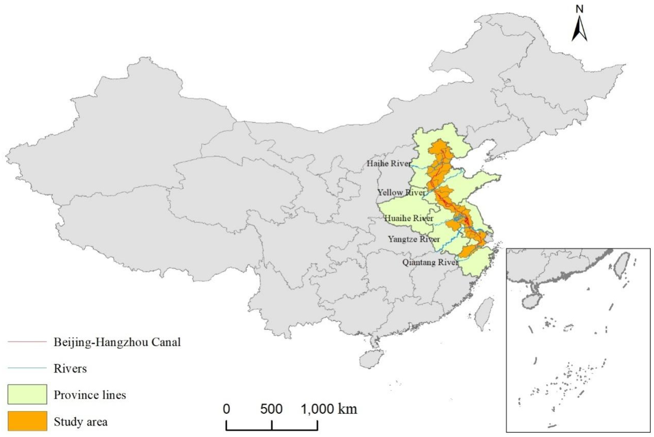
The Grand Canal is the oldest and largest canal in the world. With a total length of 1,794 kilometres, it is often called the second ‘Golden Waterway’ of China, the first being the Yangtze River. Its value is comparable to the Great Wall. The Grand Canal flows through six provinces and 21 cities from north to south, connecting five major water systems, namely, the Hai River, the Yellow River, the Huai River, the Yangtze River, and the Qiantang River (Figure 1). It also possesses one of the richest agricultural regions in China, with developed industries. This region has a high population density, intensive agriculture, and huge production potential. It also impacts the economic and cultural development of the Canal, exchanges between the northern and southern regions of China, and the development of industrial and agricultural economies along the Canal. Due to the natural environment, development policies, and land development intensity, there are significant differences in socioeconomic development between the regions. Likewise, there are significant differences in rural land use. Land is an important factor driving urban development. Rapid land urbanisation has transformed a large amount of agricultural land into urban construction land, promoting industrial development and attracting a large population to increase the land value.
Figure 1.
The location of the Grand Canal
2.2. Data Processing
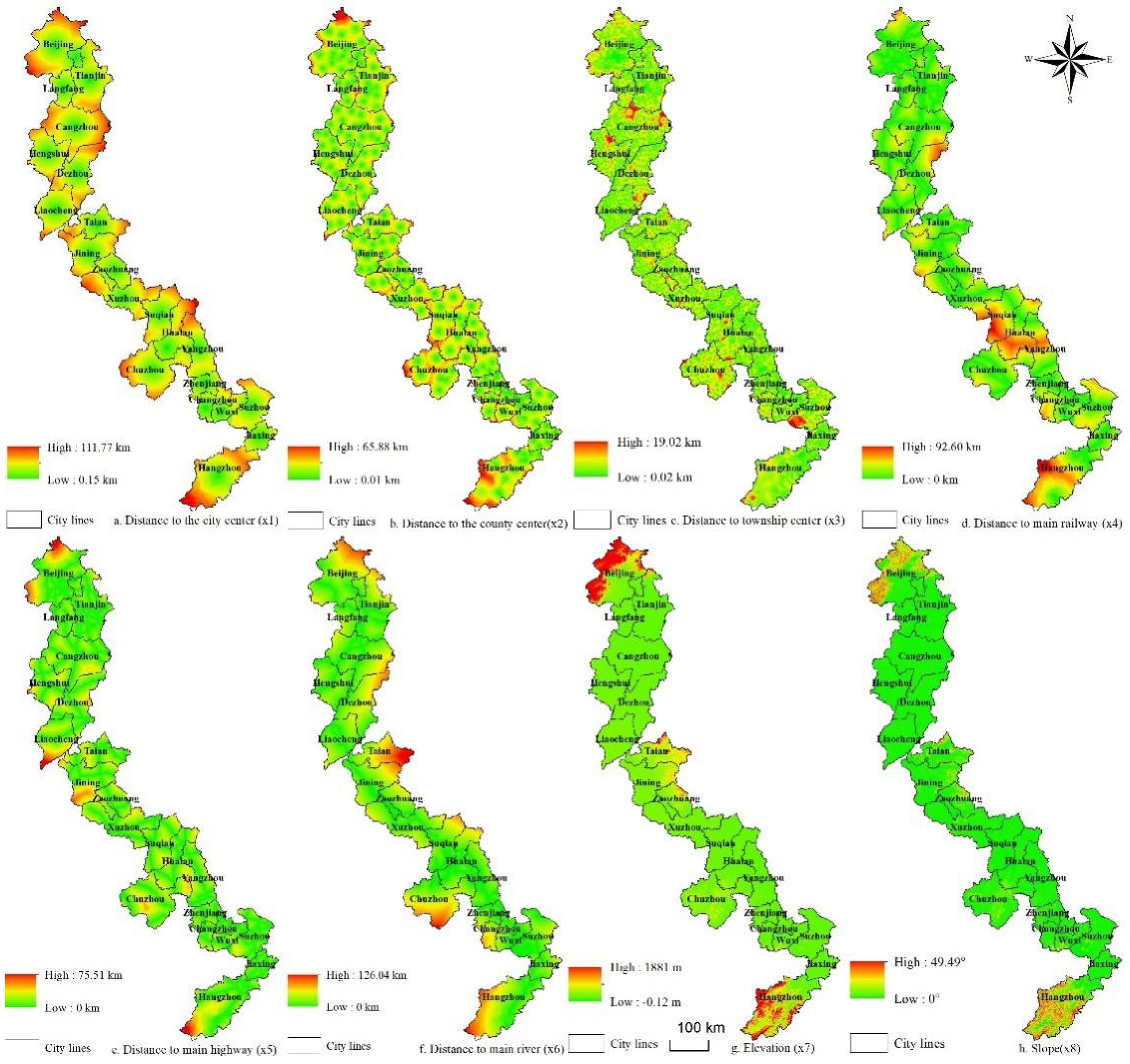
This paper uses the 100 m ×100 m grid data provided by the Resource and Environmental Science Data Centre of the Chinese Academy of Sciences to analyse the spatiotemporal distribution of rural residential land in 21 cities along the Grand Canal from 1990 to 2020. It amassed DEM data from the National Geographic Information Centre in China and analysed it through image correction and slope analysis to obtain the elevation and slope of the study area, which represent the regional driving factors of the natural environment. Using the spatial neighbourhood analysis method in ArcGIS 10.2, the study acquired the distances from each grid to major railways, rivers, motorways, or existing urban, county, and town centres. Major rivers (the watershed area exceeds 100 km2 and the river length exceeds 50 km), motorways, and railways are typical transportation arteries in each city centre. The distance from the spatial grid to each transportation artery represents the spatial axis and the driving factor of transportation accessibility. The distance to the city, county, or town centre is measured from the internal grid to the centre of the city/county/town, which represents the spatial point and a driving socioeconomic factor. As a result, this study constructed the point-axis-region three-dimensional (3D) spatial driving factor system of the Grand Canal (Table 1).

Table 1.
The point-axis-region 3D spatial driving factor system.
| Target layer | Factor layer | Element layer |
|---|---|---|
| Point | Market location (ML) | Distance to the city centre () |
| Distance to the county centre () | ||
| Distance to the town centre () | ||
| Axis | Traffic accessibility (TA) | Distance to main railways () |
| Distance to main motorways () | ||
| Distance to main rivers () | ||
| Region | Natural environment (NE) | Elevation () |
| Slope () |
Using the spatial aggregation function of ArcGIS 10.2, the study converted the land use data from 100 m to 1000 m grid data. Then, it measured the percentage of the change of rural residential land area of each grid unit using grid operation. This way it analysed the spatial differentiation of rural residential land in the cities on the Grand Canal. Converting raster data into point data, the study observed the spatial relationship between rural residential land and the driving factors. Furthermore, it used the Euclidean distance and buffer analysis to obtain the distance distribution of the driving factors, such as the urban centres and major motorways, railways, and rivers. Lastly, the study obtained a data table of rural residential land and point-axis-region 3D driving factors for geographic detector data analysis using spatial neighbourhood analysis and spatial correspondence [28,29].
2.3. The geographic detector model
Wang Jinfeng et al. (2012) introduced the geographic detector model through the factor force index, combining GIS spatial superposition technology and set theory [30] They used it to identify the interaction between multiple factors. The theory of spatial differentiation provides a means to obtain the correlation between factor variables and outcome variables. By applying different discrete classification methods to various factors, different types of variables are normalized and analysed at the same spatial scale. In this study, the dependent variable is the proportion of the change of rural residential land, whereas the independent variables are the driving factors. This study explored and analysed the impact of point-axis-region 3D driving factors on rural residential land in reference to the decisive force q of spatial differentiation of rural residential land. The formula for q is:
represents the discrete variance of the dependent variable ; represents the number of the independent variable ; represents the number of samples; represents the total number of samples in the study area; is the total variance within the study area.
This paper selected 8 driving factors as independent variables, including elevation, slope, distance to major rivers, distance to major motorways, distance to major railways, distance to urban centres, distance to county centres, and distance to town centres. It analysed the spatial differentiation of the driving factors of the rural residential land and classified the driving factors based on their data characteristics.
Table 2.
Classification of driving factors of the rural residential land.
| Factor layer | Element layer | Extremum distribution | Classification interval | Number of categories |
|---|---|---|---|---|
| Market location (ML) | Distance to the city centre () | (0.15-111.77 km) | 5 km | 23 |
| Distance to the county centre () | (0.01-65.88 km) | 5 km | 14 | |
| Distance to the town centre () | (0.02-19.02 km) | 1 km | 19 | |
| Traffic accessibility (TA) | Distance to main railways () | (0-92.6 km) | 5 km | 19 |
| Distance to main motorways () | (0-75.51 km) | 5 km | 15 | |
| Distance to main rivers () | (0-126.04 km) | 5 km | 26 | |
| Natural environment (NE) | Elevation () | (-0.12-1881 m) | 100 m | 19 |
| Slope () | (0-49.49°) | 5° | 10 |
3. Results
3.1. The characteristics of overall changes in land use
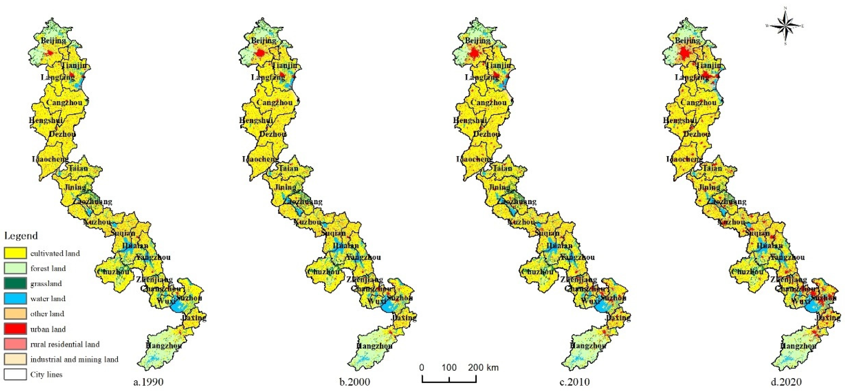
The land use types of the Grand Canal mainly include agricultural land, forest land, rural residential land, water area land, grassland, and urban construction land. In 1990, the area proportions of the six land use types were 64.6%, 12.6%, 8.8%, 8.0%, 3.1%, and 1.7%, respectively. In 2020, however, the area proportions of the six land use types were 56.6%, 12.4%, 11.3%, 8.8%, 2.8%, and 6.5%, respectively. Agricultural land, urban construction land, and rural residential land were evenly distributed. In the north, the main expansion areas of urban construction land were Beijing and Tianjin, while in the south, they were Suzhou and Wuxi. The water area land was found in Tianjin, Huai’an, Yangzhou, and Suzhou, while forest land was found in Beijing, Jining, Zaozhuang, Chuzhou, and Hangzhou.
Figure 2.
The spatial distribution of land use types in the Grand Canal (1990-2020).
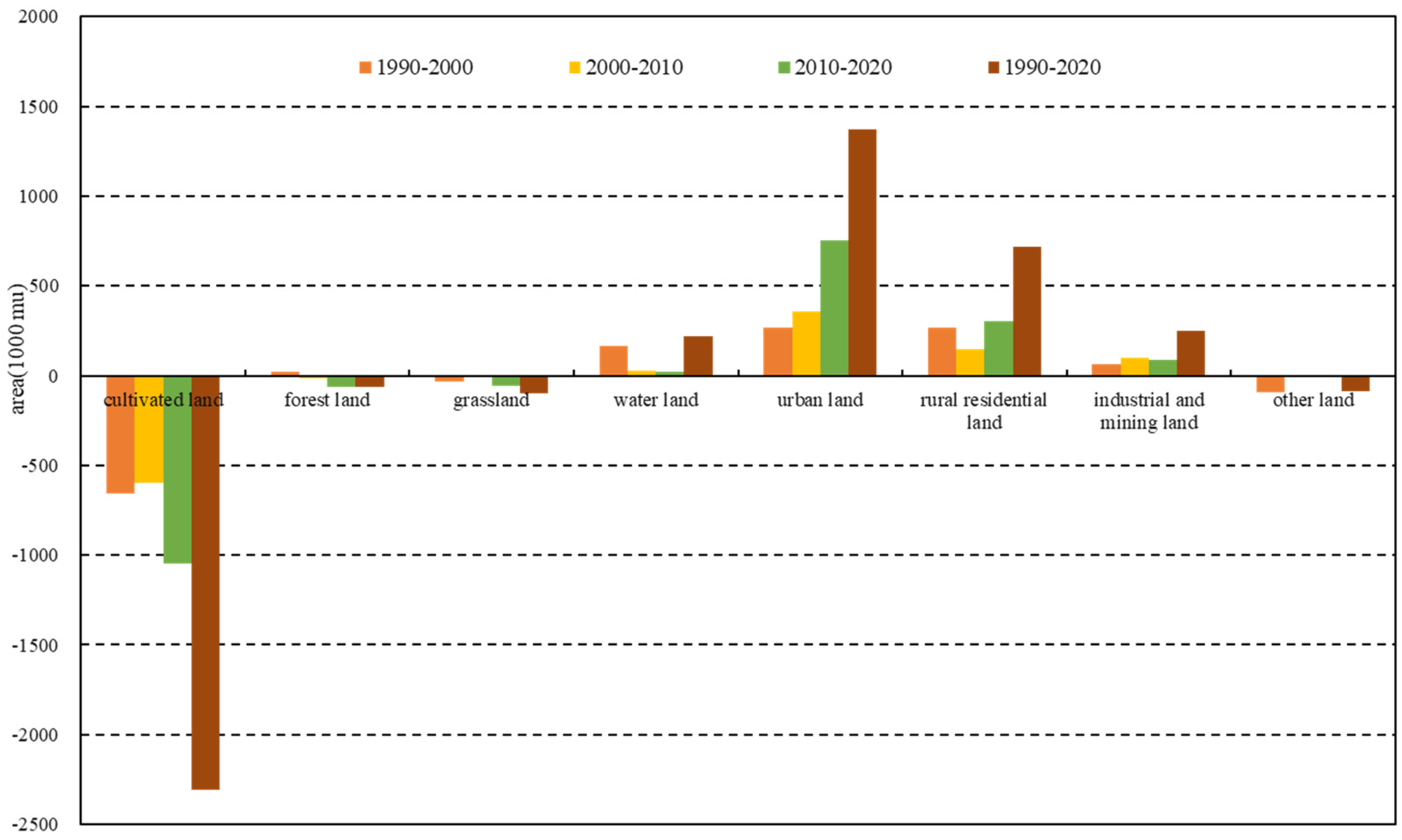
From 1990 to 2000, agricultural land, grassland, and other land decreased by 6.553 million mu, 353,000 mu, and 909,000 mu, respectively. Forest land, water area land, urban construction land, industrial and mining land, and rural residential land increased by 208,000 mu, 1.672 million mu, 2.663 million mu, 642,000 mu, and 2.649 million mu, respectively. At this stage, agricultural land and unused land were converted to water area land, urban construction land, and rural residential land. From 2000 to 2010, agricultural land, forest land, grassland, and other land decreased by 5.998 million mu, 170,000 mu, 110,000 mu, and 31,000 mu, respectively. In contrast, water area land, urban construction land, industrial and mining land, and rural residential land increased by 259,000 mu, 3.549 million mu, 1.009 million mu, and 1.492 million mu, respectively. This stage was characterized by the conversion of agricultural land to urban land and industrial and mining land. From 2010 to 2020, agricultural land, forest land, and grassland decreased by 10.502 million mu, 636,000 mu, and 544,000 mu, respectively, while water area land, urban construction land, industrial and mining land, and rural residential land increased by 232,000 mu, 7.51 million mu, 883,000 mu, and 3,011,000 mu, respectively. At this stage, agricultural land, forest land, and grassland were converted to urban industrial and mining land. From 1990 to 2020, the main areas that experienced significant changes were agricultural land, urban construction land, and rural residential land. In particular, agricultural land decreased by 23.053 million mu, accounting for 8.1% of the area. Urban construction land increased by 13.722 million mu, accounting for 4.8% of the area, while rural residential land increased by 5.6981 million mu, accounting for 2.5% of the area. It can be seen that the reduced agricultural land, forest land, and grassland on the Grand Canal was converted to urban construction land, rural residential land, or industrial and mining land.
Figure 3.
Changes in land use types and their area size on the Grand Canal during different periods.
Figure 3.
Changes in land use types and their area size on the Grand Canal during different periods.
3.2. Characteristics of changes in rural residential land
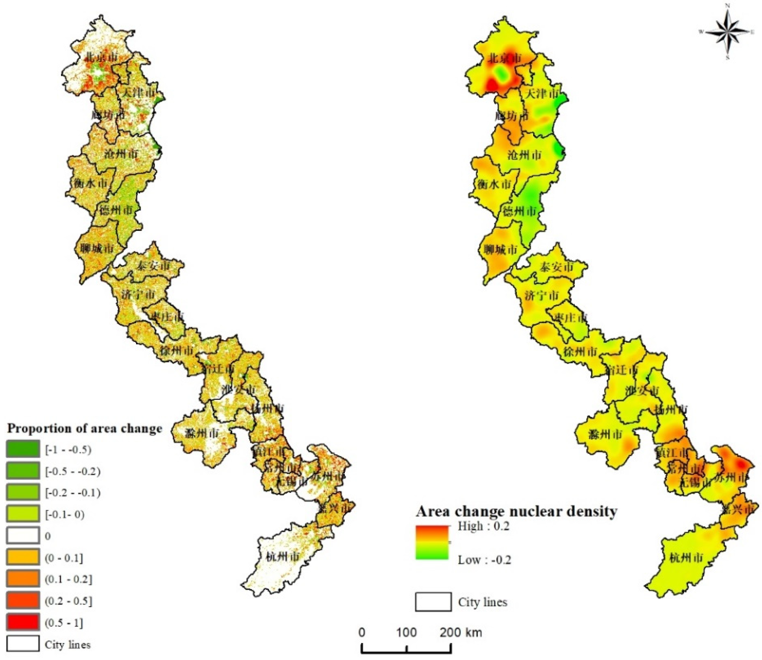
From 1990 to 2020, the distribution of changes in rural residential land was relatively uniform, mainly concentrated in villages around the central urban areas of the cities on the Grand Canal. As time passed and new policies were introduced, there had been significant changes in the spatial layout of rural residential land, with some villages experiencing a decrease or an increase in area size. Within the 1 km ×1 km grid range, the proportion of changes in rural residential land in most cities ranged from -10% to 10%. Based on the spatial distribution of rural residential land, it was found that the extremely dense rural residential land in northern cities was mainly concentrated around Beijing, where rural residential land increased over 50%. The areas with significantly sparse rural residential land were mainly distributed in Tianjin and Dezhou, where rural residential land decreased over 50%. The significant increase in rural residential land in southern cities was mainly found in Suzhou, Wuxi, Changzhou, etc. The proportion of changes in rural residential land was between 20-50%.
Figure 4.
The change in density of rural residential land (1990-2020).
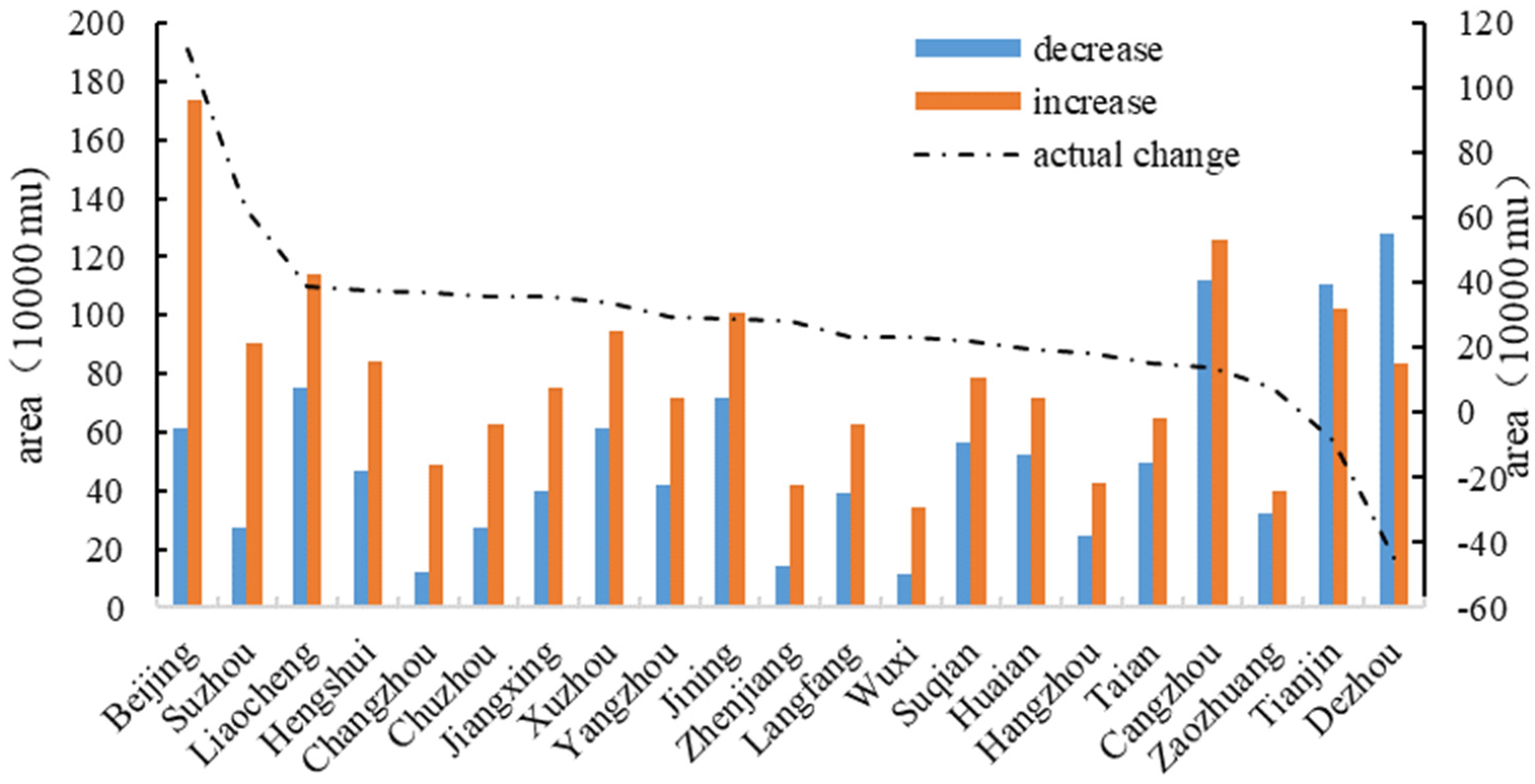
According to the changes in rural residential land area on the Grand Canal from 1990 to 2020, the total area increased by 16.6521 million mu and decreased by 10.954 million mu, resulting in an actual increase of 5.6981 million mu. Cities that have added over 1 million mu include Beijing, Cangzhou, Liaocheng, Tianjin, and Jining. Cities with an area of less than 500,000 mu include Changzhou, Hangzhou, Zhenjiang, Zaozhuang, and Wuxi. In contrast, cities with a decrease in rural residential land area of over 1 million mu include Dezhou, Cangzhou, and Tianjin, while cities with less than 300,000 mu include Chuzhou, Suzhou, Hangzhou, Zhenjiang, Changzhou, and Wuxi. Thus, it was found that the spatial changes of rural residential land in the northern cities of the Grand Canal were significant, while those in the southern cities were relatively small.
Based on the actual changes in rural residential land, it was found that only Beijing’s rural residential land increased by over 1 million mu, followed by Suzhou, with a rural residential land area of 629,000 mu. The size of rural residential land in Dezhou and Tianjin significantly decreased, with 449,500 mu and 85,100 mu, respectively. The change in size of rural residential land in 12 cities ranges from 200000 to 400000 mu, while that in Huai’an, Tai’an, Hangzhou, Cangzhou, and Zaozhuang was less than 200,000 mu. Cities with per capita rural residential land exceeding 5 mu include Chuzhou, Yangzhou, Zhenjiang, and Hangzhou. However, cities with less than 2 mu include Liaocheng, Langfang, Zaozhuang, and Jiaxing. Due to the impact of the rural population in different regions, the per capita rural residential land area in each region varied to some extent. For example, the per capita rural residential land area in the southern region of the Grand Canal was higher than that in the northern region. Thus, it can be inferred that Beijing and Suzhou, as the central cities of the northern and southern regions, respectively, had significantly higher levels of socioeconomic development and urbanisation compared to other regions. This had a strong effect on the changes in the size of rural residential land. However, as the main cities in Shandong Province began implementing the ‘Merging Villages and Towns’ policy, Dezhou significantly reduced the size of rural residential land.
Figure 5.
The change in area size of rural residential land on the Grand Canal (1990-2020).
3.3. Driving factors of rural residential land
According to the distribution characteristics of the driving factors that influence the spatial differentiation of rural residential land, it was found that the distance to the market location, such as city centres, county centres, and town centres, was distributed in a clear concentric circle. The maximum distance to city or county centres was distributed in the peripheral areas of the Grand Canal, while the maximum distance to town centres was distributed around cities, such as Cangzhou, Hengshui, and Suzhou. Furthermore, the spatial distribution of the distance to major motorways, railways, and rivers was zonal. The maximum distance to major railways was distributed in a line, from Suqian, then to Huai’an, and finally to Yangzhou. The maximum distance to major motorways was found west of Liaocheng, while the maximum distance to rivers was located east of Tai’an. Lastly, the distribution of the factors of the natural environment, such as elevation and slope, were similar, with their maximum values distributed in the northern and southern peripheral areas of the study area.
Figure 6.
The distribution of driving factors that influence the spatial differentiation of rural residential land on the Grand Canal.
Figure 6.
The distribution of driving factors that influence the spatial differentiation of rural residential land on the Grand Canal.
Using geographic detectors, this study found that all 21 cities were influenced by socioeconomic driving factors. Except for Xuzhou City, 20 cities were affected by the driving factors of transportation accessibility. Only five cities, including Beijing, Tai’an, Zaozhuang, Zhenjiang, and Hangzhou, were affected by the driving factors of the natural environment. The distance to the city centre had the greatest impact on the differentiation of rural residential land, with 20 cities being affected and an average decision-making power of 2.9. Next is the distance to the main rivers, which affected 19 cities with an average decision-making power of 1.9. The impact of elevation and slope was minimal. Elevation affected 4 cities, while slope affected 3 cities, with an average decision-making power of only 0.3 and 0.29, respectively.
To further explore the differentiation types of rural residential land in 21 cities, the study divided all cities into three categories based on the dimensions of the driving factors. Xuzhou, the only one-dimensional city, was influenced by the distance to the city and county centre. Thus, it represents a point-driven development city. Next, two-dimensional cities, including 15 cities, among which are Tianjin, Langfang, and Cangzhou, were influenced by the distance to the city, county, or town centre and the distance to the main railways, motorways, or rivers. These cities represent the main types of rural residential land, which can be termed point-axis-driven development cities. Finally, three-dimensional cities, including Beijing, Tai’an, Zaozhuang, Zhenjiang, and Hangzhou, were driven by a combination of socioeconomic factors, transportation accessibility, and the natural environment. These cities represent the ‘point-axis-region-driven development cities.’
Table 3.
Results of driving factor detection for rural residential land on the Grand Canal.
| City | X1 | X2 | X3 | X4 | X5 | X6 | X7 | X8 | Driver dimension |
|---|---|---|---|---|---|---|---|---|---|
| Beijing | 2.03 | 0.34 | 0.52 | 0.51 | 0.42 | 1.33 | 0.97 | 0.90 | three-dimensional |
| Tianjin | 3.34 | 5.31 | 1.56 | 0.58 | 0.54 | 1.99 | 0.34 | 0.13 | two-dimensional |
| Langfang | 1.47 | 1.21 | 0.21 | 0.22 | 0.29 | 2.68 | 0.12 | 0.24 | two-dimensional |
| Cangzhou | 19.12 | 9.94 | 0.77 | 0.79 | 0.65 | 4.40 | 0.13 | 0.00 | two-dimensional |
| Hengshui | 1.19 | 0.16 | 0.65 | 0.15 | 0.07 | 0.75 | 0.00 | 0.00 | two-dimensional |
| Dezhou | 4.16 | 0.25 | 0.51 | 1.34 | 0.72 | 3.15 | 0.00 | 0.00 | two-dimensional |
| Liaocheng | 1.69 | 1.12 | 0.35 | 1.23 | 0.99 | 1.14 | 0.00 | 0.00 | two-dimensional |
| Tai’an | 1.11 | 0.40 | 0.29 | 1.20 | 0.70 | 2.98 | 1.33 | 0.11 | three-dimensional |
| Jining | 0.97 | 0.60 | 0.40 | 0.20 | 0.55 | 0.37 | 0.09 | 0.06 | two-dimensional |
| Zaozhuang | 1.83 | 3.12 | 0.52 | 1.26 | 0.18 | 1.12 | 0.77 | 0.08 | three-dimensional |
| Xuzhou | 0.73 | 0.60 | 0.30 | 0.40 | 0.29 | 0.29 | 0.02 | 0.11 | one-dimensional |
| Suqian | 0.48 | 0.80 | 0.22 | 1.87 | 0.06 | 1.12 | 0.00 | 0.24 | two-dimensional |
| Huai’an | 0.89 | 0.37 | 0.30 | 2.43 | 1.71 | 0.99 | 0.00 | 0.01 | two-dimensional |
| Chuzhou | 1.89 | 0.55 | 0.79 | 2.13 | 2.53 | 5.66 | 0.06 | 0.10 | two-dimensional |
| Yangzhou | 3.00 | 0.40 | 0.05 | 1.28 | 0.31 | 0.80 | 0.09 | 0.00 | two-dimensional |
| Zhenjiang | 1.63 | 1.27 | 1.34 | 0.25 | 0.72 | 1.76 | 0.42 | 1.40 | three-dimensional |
| Changzhou | 3.67 | 1.06 | 1.16 | 1.58 | 1.21 | 2.30 | 0.27 | 0.33 | two-dimensional |
| Wuxi | 4.54 | 3.25 | 1.52 | 0.65 | 0.38 | 1.70 | 0.30 | 0.30 | two-dimensional |
| Suzhou | 3.93 | 0.50 | 0.25 | 1.41 | 0.73 | 2.09 | 0.07 | 0.24 | two-dimensional |
| Jiaxing | 1.60 | 0.18 | 0.80 | 0.57 | 0.18 | 3.14 | 0.07 | 0.28 | two-dimensional |
| Hangzhou | 1.78 | 1.32 | 0.57 | 1.46 | 0.39 | 1.19 | 1.32 | 1.62 | three-dimensional |
4. Discussion
Authors should discuss the results and how they can be interpreted from the perspective of previous studies and of the working hypotheses. The findings and their implications should be discussed in the broadest context possible. Future research directions may also be highlighted.
4.1. The conversion of rural residential land
Through spatial correction and matching analysis, it was found that agricultural land was the main source of increase in rural residential land from 1990 to 2020, accounting for 93.09%, followed by forest land, accounting for 2.17%. The main sources of decrease in rural residential land were farmland, urban construction land, water area land, and industrial and mining land, with a proportion of 68.11%, 19.0%, 5.41%, and 5.03%, respectively. To further analyse the driving factors of the change in rural residential land in various cities, this study chose Beijing, Cangzhou, Dezhou, Chuzhou, Huai’an, Suzhou, Jiaxing, and Hangzhou cities as cases where the change in rural residential land was most prominent. It based the analysis on the driving factors and change in area size using an equal proportion amplification method.
4.1.1. The conversion of rural residential land in the one-dimensional city
The only one-dimensional city in this study was Xuzhou. From 1990 to 2020, the area of rural residential land increased by 949,000 mu and decreased by 612,000 mu, thus actually increasing by 337,000 mu. The main sources of increase in rural residential land were agricultural land and forest land, with an area of 884,100 mu and 32,100 mu, respectively, accounting for 93.2% and 3.39%. However, the main source of decrease was also agricultural land, followed by urban construction land, with an area of 407,500 mu and 174,900 mu, respectively, accounting for 66.58% and 28.59%. This indicates that the source of changes in rural residential land in Xuzhou was agricultural land. The change was mainly influenced by socioeconomic driving factors, such as the distance to the city and county centre, with a decision-making power of 0.73 and 0.60, respectively. Due to the fact that Xuzhou is located in the North China Plain and is flat, it was less affected by the driving factors of the natural environment. Moreover, Xuzhou is an important transportation hub that connects the Grand Canal to the eastern and western regions of China. Its main motorway and railway network density were relatively high, so it had little impact on the spatial differentiation of rural residential land.
4.1.2. The conversion of rural residential land in two-dimensional cities
To examine the changes in rural residential land in two-dimensional cities, the study selected Cangzhou, Dezhou, Suqian, and Suzhou as representatives. It found differences in the number of the driving factors affecting each city. There were also differences in the changes in rural residential land. Due to the large number of two-dimensional cities, they were mainly influenced by the distance to the city, county, or town centre and the distance to major railways, motorways, or rivers. In contrast, they were less affected by the driving factors of the natural environment.
The actual changes in rural residential land from 1990 to 2020 were 141,000 mu in Cangzhou, -449,500 mu in Dezhou, 222,400 mu in Suqian, and 629,000 mu in Suzhou. Suzhou is the economic centre of the southern part of the Grand Canal. In Suzhou, the actual increase in rural residential land area was second only to Beijing. The main sources of increase in rural residential land were agricultural land, water area land, and urban construction land, with an area proportion of 92.14%, 3.27%, and 2.66%, respectively. The main sources of decrease in rural residential land were urban construction land, agricultural land, and water area land, with an area proportion of 59.29%, 33.83%, and 4.07%, respectively. This city was mainly influenced by four driving factors, including the distance to the city centre, the distance to main railways, the distance to main motorways, and the distance to main rivers, with a decision-making power of 3.93, 1.41, 0.73, and 2.09, respectively. Furthermore, Dezhou is one of the central cities of the Grand Canal. It experienced a negative growth in rural residential land from 1990 to 2020. The main sources of increase in rural residential land were agricultural land and other land, with an area proportion of 93.84% and 3.73%, respectively. However, the main source of decrease in rural residential land was also agricultural land, followed by urban construction land, with an area proportion of 89.0% and 8.97%, respectively. This city was influenced by five driving factors, including the distance to the city centre, the distance to the town centre, the distance to main railways, the distance to main motorways, and the distance to main rivers. Each of these factors had a decision-making power of 4.16, 0.51, 1.34, 0.74, and 3.15, respectively. Next, Cangzhou is a city in the northern part of the Grand Canal. From 1990 to 2020, the increase and decrease in rural residential land exceeded 1 million mu. The main source of increase in rural residential land was agricultural land, accounting for 97.01% of the total area. The main sources of decrease in rural residential land were agricultural land, water area land, industrial and mining land, and urban construction land, with an area proportion of 65.06%, 18.31%, 12.46%, and 3.62%, respectively. This city was influenced by six driving factors, including the distance to the city centre, the distance to the county centre, the distance to the town centre, the distance to main railways, the distance to main motorway, and the distance to main rivers. These factors had a decision-making power of 19.12, 9.94, 0.77, 0.79, 0.65, and 4.40, respectively. Like Dezhou, Suqian is also one of the medial cities of the Grand Canal. It experienced a change in rural residential land area of less than 300,000 mu. The main source of increase in rural residential land was agricultural land, accounting for 96.98% of the total area. The main sources of decrease in rural residential land were agricultural land and urban construction land, with an area proportion of 72.43% and 25.34%, respectively. This city was mainly influenced by the distance to the county centre, the distance to main railways, and the distance to main rivers, each of which had a decision-making power of 0.80, 1.87, and 1.12, respectively.
4.1.3. The conversion of rural residential land in three-dimensional cities
To show the change of rural residential land in three-dimensional cities, this study selected Beijing and Hangzhou as representatives. From 1990 to 2020, the area of rural residential land increased by 1.736 million mu in Beijing and 430,000 mu in Hangzhou. It decreased by 616,000 mu and 248,000 mu, respectively. The actual increase in Beijing was 1.12 million mu and 182,000 mu in Hangzhou. The main sources of increase in rural residential land in Beijing were agricultural land, forest land, and grassland, with an area proportion of 85.46%, 7.57%, and 2.6%, respectively. The main sources of decrease in rural residential land were urban construction land, agricultural land, industrial and mining land, and forest land, with an area proportion of 51.83%, 23.59%, 13.35%, and 5.67%, respectively. The driving factors of rural residential land in Beijing were the distance to the city centre, the distance to the town centre, the distance to main railways, the distance to main rivers, elevation, and slope. Their decision-making power was 2.03, 0.52, 0.51, 1.33, 0.97, and 0.90, respectively. In Hangzhou, the main sources of increase in rural residential land were agricultural land and forest land, with an area proportion of 86.76% and 10.39%, respectively. The main sources of decrease in rural residential land were agricultural land, urban construction land, industrial and mining land, and forest land, with an area proportion of 49.52%, 23.21%, 11.42%, and 11.27%, respectively. Similar to Beijing, the driving factors for rural residential land in Hangzhou include the distance to the city centre, the distance to the county centre, the distance to the town centre, the distance to main railways, the distance to main rivers, elevation, and slope. Their decision-making power was 1.78, 1.32, 0.57, 1.46, 1.19, 1.32, and 1.62, respectively.
Beijing and Hangzhou are both economically developed cities in the northern and southern parts of the Grand Canal, respectively. As the capital of China, Beijing is a political, economic, and cultural centre, with the largest area size in rural residential land and the greatest scale of converting rural residential land to urban construction land. Due to socioeconomic development, the central urban area represents the main area where people live and work. Urban construction land continues to expand to the periphery, occupying a large amount of rural residential land and agricultural land. To meet the production and living demands of rural residents, a large amount of agricultural land has been transformed into new rural communities. The transportation network and various terrain types in Beijing have a significant impact on the selection of the space where rural residential land can be built, especially in the northern mountainous areas of Beijing, where the density of rural residential land is low, and the proportion of its change is small.
As the capital of Zhejiang Province, Hangzhou is an important city in the Yangtze River Delta Economic Zone. The density of transportation arteries, such as railways and motorways, is high. Likewise, the speed at which urban construction land is expanding is high. Due to the influence of urban terrain and landforms, especially in the mountainous areas in the southern part of the city, the proportion of rural residential land converted to urban construction land is relatively low and the proportion of the increase in rural residential land is relatively small.
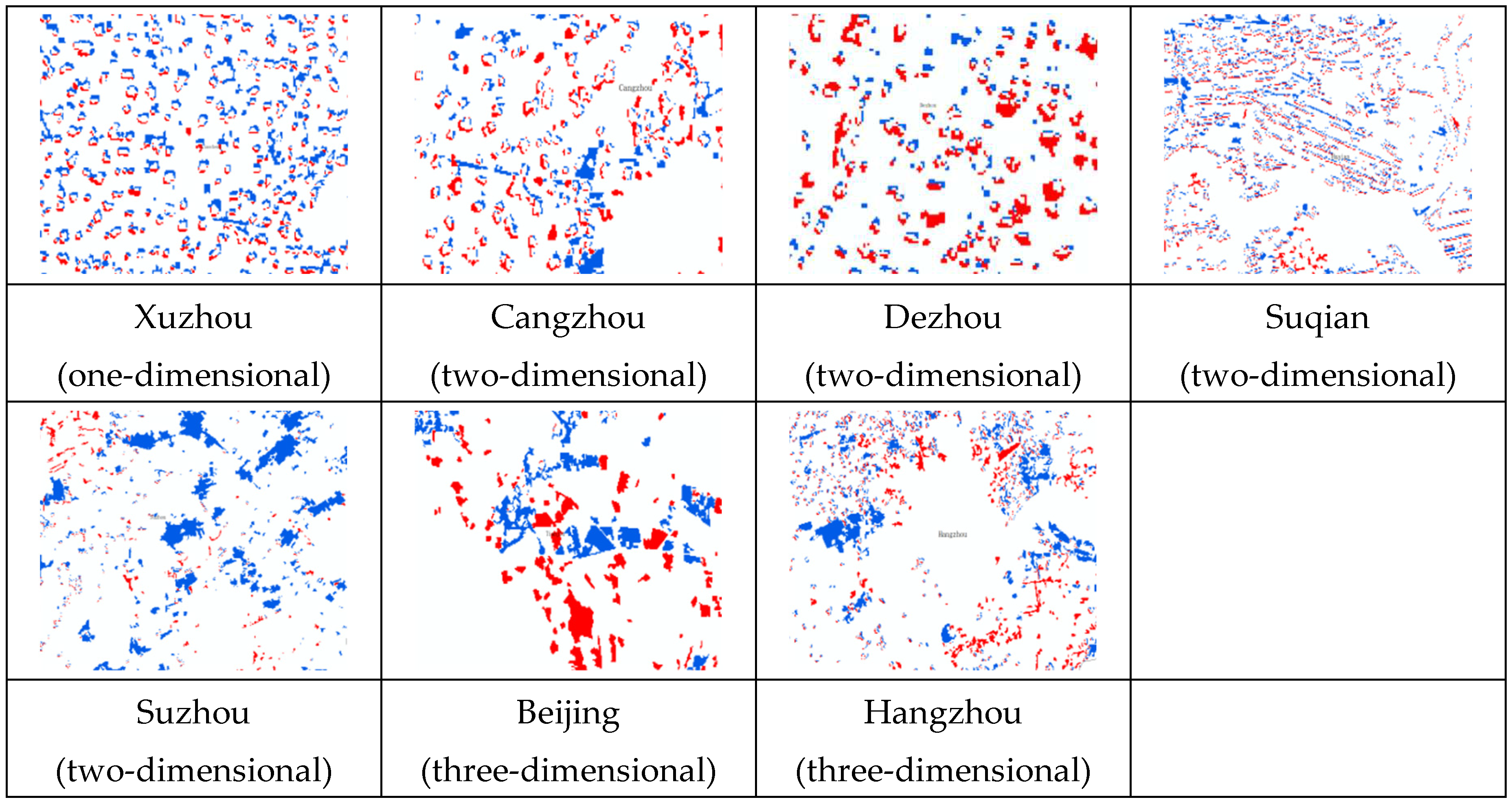
Figure 7.
Main types of changes in rural residential land in the Grand Canal.
4.2. Driving factors of the change in rural residential land
Based on the distribution characteristics of rural residential land in the cities and the influence of their point-axis-region 3D driving factors, this study further analysed the driving factors of the change in rural residential land on the Grand Canal by combining the sources of increase and decrease in rural residential land in the cities. This has important implications for accelerating the high-quality development of rural social economy and improving the land use efficiency of rural residential land.
4.2.1. Socioeconomic driving factors
The socioeconomic driving factors include the distance to the city centre, county centre, or town centre. Among the 21 cities on the Grand Canal, 8 cities were affected by these driving factors, while Suzhou, Yangzhou, and Tai’an were affected only by the distance to the city centre. Due to rapid urbanisation, urban centres, the densely populated industrial areas and also central areas of regional socioeconomic development, have increased their demand in land and the size of urban land, leading to the occupation of surrounding rural residential land and agricultural land. Therefore, the rural residential land close to the urban area was reduced. To meet the demands of rural residents, a large amount of agricultural land was converted to rural residential land to establish new communities and build new residential areas in the suburbs. It was found that rural residential land around the urban centre exhibited a block-like change, radiating to the surrounding area in a concentric circular shape. This result is most observable in the increase or decrease in rural residential areas in Beijing and Suzhou (Figure 8).
4.2.2. Driving factors of transportation accessibility
The driving factors of transportation accessibility include the distance to main railways, motorways, and rivers. Among the 21 cities on the Grand Canal, 9 cities were affected by these factors. Langfang, Hengshui, and Jining were affected only by the distance to the main rivers. In these places, rapid industrialisation and urbanisation have led to the large-scale development of transportation arteries and primary roads, which have contributed to the socioeconomic development of urban and rural areas. At the same time, the efficient and smooth operation of transportation arteries caused changes in land use along their routes, especially at crucial transportation hubs. To ensure the transportation of industrial and agricultural produce, most industrial parks were built along the main transportation arteries, occupying a large amount of agricultural and rural residential land. Thus, the rural residential land moved to the periphery of the transportation arteries and the surrounding areas. This study found that rural residential land surrounding the transportation arteries exhibited a linear change, i.e., it was distributed in a line towards the surrounding areas. Examples of these can be seen in the rural residential land in Suqian, where the increase or decrease of rural residential land was observed in a linear pattern (Figure 8).
4.2.3. Driving factors of the natural environment
The driving factors of the natural environment include elevation and slope. Among the 21 cities on the Grand Canal, Beijing and Hangzhou were affected by these factors. However, Tai’an and Zaozhuang were mainly affected by elevation, while Zhenjiang was affected by slope. The driving factors of the natural environment are relatively stable factors and have a significant impact on the spatial distribution and location of rural residential land, especially in the early stages of rural residential construction in which residential land was built on flat terrain and low elevation. As urban construction land expanded, rural residential land was continually being occupied and some flat and low-lying areas in cities were converted to urban land. Nevertheless, rural residential land can only expand in three-dimensional spaces. The mountainous regions and ecological protection areas in the northern part of Beijing and the southern part of Hangzhou are unsuitable for the development of rural residential land due to high altitudes and rugged terrain. Thus, rural residential land in Beijing and Hangzhou established new high-quality communities to improve land use efficiency in rural residential areas (Figure 8).
4.3. Optimization and adjustment of rural residential land
This study found that there were significant differences in the distribution of rural residential land due to different driving factors that affected the northern and southern cities on the Grand Canal. Although China has already introduced policies on rural residential land, the rural population is constantly decreasing. Due to practices such as the construction of new buildings without demolishing old ones, the migration of rural residents to urban areas, and the conversion of rural residential land for non-agricultural uses, the size of rural residential land in the city expanded from 1990 to 2020, posing a serious threat to farmland protection and rapid urbanisation in the new era. Based on the driving factors and the distribution of rural residential land, this study offered suggestions for planning and controlling rural residential land in different cities, as well as suggestions for their intensive and economical use.
4.3.1. The construction of large-scale villages through relocation and consolidation
Due to abandoned homesteads, especially in the central plain areas of the Grand Canal, including Dezhou, Liaocheng, and Cangzhou, the scale of rural residential land has increased. However, the rural population has decreased significantly. This study proposes that old residential sites with high levels of point-axis-region 3D driving factors should be transformed into the central village. The abandoned surrounding villages with poor waste management should be relocated to the central village, which would be equipped with high-level service facilities and infrastructure. By reconstructing the spatial layout of the village, rural grassroots, and industrial parks, it is possible to build a new type of village with high social and economic development capabilities. The reconstructed central village would serve as a centre for industrial and agricultural production and living, encouraging the old and new residents to achieve social and economic development in the new village. After the demolition, the village would adopt engineering measures, such as land remediation and reclamation, to develop a large and connected land for agricultural use. This land would then provide a more stable channel for collective economic income through subleasing, transfer, and collective management, providing financial support for the development of new village industries and facilities.
4.3.2. The construction of new villages through relocation and reconstruction
Relatively small and scattered village are located in the northern and southern remote mountainous regions of the Grand Canal. These villages are situated at high altitudes and slopes, far from major cities and transportation arteries. In these villages, residential land is also located in ecologically fragile areas or areas prone to natural disasters. This land has unfavourable conditions for industrial and agricultural production and cannot support social and economic development. By relocating scattered villages, small villages would be transformed into larger ones. This would, in turn, group the population of the villages in one place, enable the reclamation of farmland and homesteads, and convert land in ecological protection areas to forests and grassland. The construction of new rural areas requires local investment from the state, local governments, social enterprises, and village collectives, leveraging the power of diverse entities, and conducting careful layout planning. The collective economic development of new villages would need to rely on multiple factors for their development, especially government financial support. By introducing new technologies to develop characteristic industries in the new villages, sustainable development can be ensured.
4.3.3. The construction of advanced villages through intensive expansion and contraction
Some rural residential land has a large land area and a relatively low level of waste management. It also has villages with abandoned residential buildings. These villages are concentrated in the suburbs of Suzhou and Zhenjiang in the southern part of the Grand Canal. Considering the current state of the rural residential land, which includes abandoned villages, roadside villages, and ribbon villages, with a large area for settlement and a favourable location, the land near the main transportation arteries would be transformed into commercial housing and shop houses in the process of intensive expansion and contraction. Residents on this land would be relocated to residential land of the same size as in their former village. This could be achieved through spatial replacement, intra-village rectification, and spatial layout planning. The village committee should purchase, decorate, and renovate empty residential buildings, transform them into village collective assets, and use them as channels for increasing the collective rural economic income through subleasing and other forms to provide financial support for improving the construction of village facilities and the appearance of houses.
5. Conclusions
Due to urbanisation, the rural population has migrated to urban areas, resulting in a decrease in the efficiency of rural residential land use and an increase in the number of abandoned rural homesteads. In the context of integrating urban and rural areas and protecting farmlands, one key issue requires immediate attention. This issue deals with the scientific analysis of the remaining rural residential land to ensure the improvement of its land use efficiency. This study observed 21 cities on the Grand Canal and analysed the spatiotemporal differentiation of their rural residential land under various driving factors using geographic detectors. It offered suggestions for scientific planning of rural residential land according to local conditions and provided reference for the conservation and intensive use of that land. This study drew the following conclusions.
(1) The cities with a significant increase in rural residential land (over 1 million mu) in the Grand Canal were concentrated in the north, including Beijing, Tianjin, Cangzhou, etc. The cities with a smaller decrease (less than 300,000 mu) were mainly concentrated in the south, including Suzhou, Hangzhou, Zhenjiang, etc. It was found that the changes in rural residential land in the northern cities were significant. In contrast, the changes in rural residential land in the southern cities were relatively stable. The main sources of increase in the rural residential land include agricultural land and forest land, while the main sources of decrease include urban industrial and mining land and agricultural land. From 1990 to 2020, rural residential land experienced a cycle of changes in agricultural land, rural residential land, and urban construction land.
(2) The driving factors that affected the spatiotemporal differentiation of rural residential land were mainly manifested as socioeconomic factors (points), transportation accessibility (axes), and the natural environment (regions). According to the number of driving factors and their decision-making power (greater than 0.5), the 21 cities were divided into three types: one-dimensional, two-dimensional, and three-dimensional cities. The one-dimensional city, Xuzhou, was mainly influenced by socioeconomic factors. In this city, significant differences in the change of rural residential land could be spotted around urban centres. Moreover, the two-dimensional cities were mainly influenced by socioeconomic factors and factors of transportation accessibility. This city type included 15 cities, such as Tianjin, Langfang, and Yangzhou. In these cities, rural residential land was found in circular and linear patterns around the urban centre and main transportation arteries. Finally, the three-dimensional cities were influenced by all driving factors. This city type included five cities, such as Beijing, Hangzhou, and Tai’an. Apart from the rural residential land exhibiting a linear and circular pattern, the distribution of rural residential land in these cities was relatively scattered due to the rugged terrain.
(3) Based on the spatial differentiation characteristics and driving factors of rural residential land, this study proposed three types of villages to ensure the intensive use and careful planning of rural residential land and the protection of agricultural land, and improve the efficiency of rural residential land use. These villages would be developed based on the following strategies: the construction of large-scale villages through relocation and consolidation, the construction of new villages through relocation and reconstruction, and the construction of advanced villages through intensive expansion and contraction. The relocation and consolidation of rural areas implies using old residential areas as the central village, merging multiple scattered villages in the surrounding area, and freeing up excess rural residential land and transforming it into agricultural land. Relocation and reconstruction-oriented rural areas imply building new villages in other suitable locations, relocating multiple existing villages, and constructing new larger villages. The original rural residential land would be converted to farmland, forests, or grasslands. These areas would then focus on ecological restoration. Intensive expansion and contraction of rural areas implies that they retain the original villages, improve the level of rural housing through renovation, move scattered rural homesteads to central villages through spatial replacement, transform the remaining rural homesteads into collective assets, and build commercial housing or shop houses to increase the collective economic income.
Author Contributions
Conceptualization, J.L. and Y.G.; methodology, L.C.; data curation, J.L.; writing—original draft preparation, Y.G.; writing—review and editing, J.L.; visualization, J.L.; funding acquisition, J.L. All authors have read and agreed to the published version of the manuscript.
Funding
This research was funded by the National Natural Science Foundation of China (42001192), Major Project of Philosophy and Social Sciences Research by the Ministry of Education(21JZD014), China Postdoctoral Science Foundation (2019M662329), and the Youth Team Project of Shandong University (IFYT20004).
Data Availability Statement
Data Availability Statements are available in section “MDPI Research Data Policies” at https://www.mdpi.com/ethics.
Acknowledgments
In this section, you can acknowledge any support given which is not covered by the author contribution or funding sections. This may include administrative and technical support, or donations in kind (e.g., materials used for experiments).
Conflicts of Interest
The authors declare no conflict of interest.
References
- Li, H.J., Zhou, X.L., Tang, M.Q., Guo, L.L. Impact of Population Aging and Renewable Energy Consumption on Agricultural Green Total Factor Productivity in Rural China: Evidence from Panel VAR Approach. Agriculture 2022, 12, 1–9.
- Wei, J.Z. Wei, J.Z., Zheng, K., Zhang, F., Fang, C., et al. Migration of Rural Residents to Urban Areas Drives Grassland Vegetation Increase in China’s Loess Plateau. Sustainability 2019, 11, 1–18. [Google Scholar]
- Shan, Z.T, Feng, C.C. The Redundancy of Residential Land in Rural China: The evolution process, current status and policy implications. Land use policy 2018, 74, 179–186. [CrossRef]
- Xu, F., Ho, H.C., Chi, G.Q., Wang, Z.Q. Abandoned rural residential land: Using machine learning techniques to identify rural residential land vulnerable to be abandoned in mountainous areas. Habitat International 2019, 84, 43–56. [CrossRef]
- Zhang, F.Z. Zhang, F.Z., Chung, C.K.L., Yin, Z.H. Green infrastructure for China’s new urbanisation: A case study of greenway development in Maanshan. Urban Studies 2019, 57, 508–524. [Google Scholar]
- Zhang, Z.F., Liu, J., Gu, X.K. Reduction of industrial land beyond Urban Development Boundary in Shanghai: Differences in policy responses and impact on towns and villages. Land Use Policy 2019, 82, 620–630. [CrossRef]
- Cheng, L. An Evaluation of Contemporary China’s Land Use Policy—The Link Policy: A Case Study from Ezhou City, Hubei Province. Contemporary China’s Land Use Policy 2020, 89–116. [Google Scholar]
- Gao, W.W., Vries, W.T.D., Zhao, Q.Y. Understanding rural resettlement paths under the increasing versus decreasing balance land use policy in China. Land Use Policy 2021, 103, 105325. [CrossRef]
- Shi, C.F., Li, L.J., Chiu, Y.H., Pang, Q.H., et al. Spatial differentiation of agricultural water resource utilization efficiency in the Yangtze River Economic Belt under changing environment. Journal of Cleaner Production 2022, 346, 1–13.
- Xu, M.Y. Xu, M.Y., Zhang, Z.F. Spatial differentiation characteristics and driving mechanism of rural-industrial Land transition: A case study of Beijing-Tianjin-Hebei region, China. Land Use Policy 2021, 102, 1–17. [Google Scholar]
- Cai, W.B. Cai, W.B., Peng, W.T. Exploring Spatiotemporal Variation of Carbon Storage Driven by Land Use Policy in the Yangtze River Delta Region. Land 2021, 10, 1–12. [Google Scholar]
- Li, X.J., Zhang, M.M., Wang, J.H. The spatio-temporal relationship between land use and population distribution around new intercity railway stations: A case study on the Pearl River Delta region, China. Journal of Transport Geography 2022, 98, 1–11.
- Islam, S., Papia, M.J., Yesmin, S. The Rural-Urban Migration and its Socio-Economic Consequences: A Study on the Rayerbazar Area of Dhaka City. International Journal of Publication and Social Studies 2022, 7, 12–18. [CrossRef]
- Duan, Y., Wang, H., Huang, A., et al. Identification and spatial-temporal evolution of rural "production-living-ecological" space from the perspective of villagers’ behavior – A case study of Ertai Town, Zhangjiakou City. Land Use Policy 2021, 106, 105457. [CrossRef]
- Shi, L., Wang, Y. Evolution characteristics and driving factors of negative decoupled rural residential land and resident population in the Yellow River Basin. Land Use Policy 2021, 109, 1–8.
- Ismail, I.M., Summan, A.S., Basahi, J.M., et al. First Measurements of Carbonaceous Aerosol across Urban, Rural and Residential Areas in Jeddah City, Saudi Arabia. Asian Journal of Atmospheric Environment 2021, 15, 30–43.
- Factors Influencing Rural Households’ Decision-Making Behavior on Residential Relocation: Willingness and Destination. Land 2021, 10, 1–8.
- Saito, T., Kitamura, Y., Tanaka, E., et al. Spatial distribution of anti-Toxoplasma gondii antibody-positive wild boars in Gifu Prefecture, Japan. Scientific reports 2021, 11, 17207. [CrossRef]
- Chen, Z.F., Li, Y.R., Liu, Y.S., Liu, X.Q. Does rural residential land expansion pattern lead to different impacts on eco-environment? A case study of loess hilly and gully region, China. Habitat International 2021, 117, 102436. [CrossRef]
- Rahman, M.M., Hossain, T., Chowdhury, M., et al. Effects of Transportation Accessibility on Residential Housing Rent: Evidence from Metropolitan City of Khulna, Bangladesh. Journal of urban planning and development 2021, 147, 1–15.
- Yin, X.Z., Yu, J.Q, Dong, Q., et al. Energy Sustainability of Rural Residential Buildings with Bio-Based Building Fabric in Northeast China. Energies 2020, 13, 1–14.
- Zhou, T., Jiang, G.H., Li, G.Y., et al. Neglected idle rural residential land (IRRL) in metropolitan suburbs: Spatial differentiation and influencing factors. Journal of Rural Studies 2020, 78, 163–175. [CrossRef]
- Chen, Z., Liu, X., Lu, Z., et al. The Expansion Mechanism of Rural Residential Land and Implications for Sustainable Regional Development: Evidence from the Baota District in China’s Loess Plateau. Land 2021, 10, 1–16.
- Zhou, T., Jiang, G.H., Ma, W.Q., et al. Dying villages to prosperous villages: A perspective from revitalization of idle rural residential land (IRRL). Journal of Rural Studies 2021, 84, 45–54. [CrossRef]
- Wang, H., Wang, L.L., Su, F.B., Tao, R. Rural residential properties in China: Land use patterns, efficiency and prospects for reform. Habitat International 2012, 36, 201–209. [CrossRef]
- Prus, B., Dudzińska, M., Bacior, S. Determining and quantifying the historical traces of spatial land arrangements in rural landscapes of Central and Eastern Europe. Scientific reports 2021, 11, 1–16.
- Ogrodnik, K.; Kolendo, U. Application of gis technology and AHP to determine the areas with fully developed, compact functional and spatial structure: A case study of Bialystok, Poland. Land Use Policy 2021, 109, 105616. [Google Scholar]
- Cheng, X.H., Xu, D.F., Sun, H., et al. Rural Spatial Differentiation and Revitalization Approaches in China: A Case Study of Qingdao City. International Journal of Environmental Research and Public Health 2022, 19, 16924. [CrossRef]
- Li, J.T.; Gong, Y. L. Spatial location differentiation and development decision optimization of characteristic villages and towns in China. Geography and Sustainability 2022, 3, 21–31. [Google Scholar]
- Wang, J.F.; Hu, Y. Software, data and modelling news: Environmental health risk detection with GeogDetector; Elsevier Science Publishers B. V.; p. 2012.
Disclaimer/Publisher’s Note: The statements, opinions and data contained in all publications are solely those of the individual author(s) and contributor(s) and not of MDPI and/or the editor(s). MDPI and/or the editor(s) disclaim responsibility for any injury to people or property resulting from any ideas, methods, instructions or products referred to in the content. |
© 2023 by the authors. Licensee MDPI, Basel, Switzerland. This article is an open access article distributed under the terms and conditions of the Creative Commons Attribution (CC BY) license (http://creativecommons.org/licenses/by/4.0/).
Copyright: This open access article is published under a Creative Commons CC BY 4.0 license, which permit the free download, distribution, and reuse, provided that the author and preprint are cited in any reuse.


