
Submitted:
12 April 2023
Posted:
13 April 2023
You are already at the latest version
Abstract
The report [1] shows that in many European cities the sewer system is older than 40 years, potentially reducing their ability to cope with more intense pluvial flooding [2] addition to climate change, urbanization is an important factor increasing the flooding risk, as it increases of impervious surfaces. Flash floods are particularly troublesome, causing not only the overloading of drainage systems [3], but also urban transport disruption, affecting human health, and contributing to pollution due to untreated sewage discharges [4]. Pluvial floods in urban areas are caused by short-duration precipitation, high intensity and on small scale. Such rainfall is difficult to predict and does not always apply to catchment areas. In Poland, heavy rainfall lasts relatively short, from a few minutes to a few, at most, several hours [5]. The method of the Analytic Hierarchy Process (AHP) was used to rank the importance of criteria characterizing exposure in urban areas. The ranking is based on expert judgements. The article focuses on exposure which is one of the components of risk. Geographical Information System (GIS) is integrated with Multicriteria Decision Analysis (MCDA) to evaluate exposure of urban area on pluvial floods.
Keywords:
flood risk
; urban areas
; vulnerability
; exposure
; pluvial floods
; Analytic Hierarchy Process
1. Introduction
The observed climate change is causing an increase in the frequency and intensity of extreme meteorological and hydrological events (e.g. storms, floods, heat waves, or heavy rainfall) all over the world. The resulting risk depends not only on climate change but also significantly on changes in land use. Urbanization and the associated land sealing are leading to increasing risks, especially in urban areas. „Climate change is expected to lead to an increase in precipitation in many areas. Increased rainfall over extended periods will mainly lead to fluvial (river) flooding, while short, intense cloudbursts can cause pluvial floods, where extreme rainfall causes flooding without any body of water overflowing” [6]. Studies [7] show that the average annual losses caused by multiple flash floods are almost equal to large river floods, that occur once in a century.
However, the future costs of climate-related hazards depend not only on the frequency and severity of events but also on several other factors such as the size of the population and the value of assets at risk. [8]. Spatial development and urbanisation processes in the European Union (EU) countries are subject to regulations, thus creating a framework for integrated urban development. Many European Union policies and laws promote sustainable development, land use, and urban safety. Identifying the locations of rainfall flooding areas and developing accurate maps based on them are crucial for spatial planning and flood management at the local scale [9]. It is equally important to conduct susceptibility and exposure studies. The issue of pluvial floods was taken up at the Institute of Meteorology and Water Management - National Research Institute (IMWM-NRI) as part of the research work. Currently, research focuses on the vulnerability of urban areas determined by a set of physical, economic, social and environmental factors (variables) that increase the vulnerability of areas to flood risk, and the capacity determined by a set of factors characterizing the potential existing in these areas to reduce the risk. The article focuses on exposure which is one of the components of risk.
2. Materials and Methods
2.1. Risk assessment model
In the model of pluvial flood risk assessment in urban areas, a more specific definition of risk as a function of hazard (H), vulnerability (P), and exposure (E) was adopted. This qualitative approach to risk assessment provides an opportunity to explore the interactions between the last three elements.
R=f(H, P, E) [10]
Potential negative consequences related to the flood were assessed in four categories: the impact of the flood on human life and health, economic activity, transport, and telecommunications infrastructure, as well as on cultural heritage. This approach is a modification of the definition from the Floods Directive [11], which also assesses the negative impact of flooding on the environment.
The risk assessment model used in the research includes the key elements of the urban area. The model does not include the cascading risk, and thus the reaction of environmental elements such as water, soil, and air to the negative consequences resulting from infrastructure failures that may contaminate them. Nevertheless, the model includes the importance of endangered objects in the context of potential losses. The risk assessment model adopted in the study shows the figure below.
Figure 1.
Key elements of vulnerability.
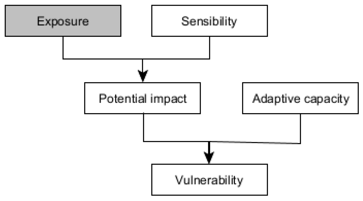
The following definition of exposure was adopted in the risk assessment model “Exposure: The presence of people; livelihoods; environmental services and resources; infrastructure; or economic, social, or cultural assets in places that could be adversely affected” [12]. In the flood risk assessment model, to examine the exposure of urban areas to pluvial floods, the above definition of exposure to four main criteria was adopted: “Human life and health”, “Economic activity”, “Transport and telecommunications infrastructure” and “Cultural heritage”.
2.2. Study Area
The meridional extent of the Krakow commune is 18 km, and the latitudinal length is 31 km [13]. The area is about 327 km2. In geographical terms, Krakow is located at the junction of eleven physical-geographical mesoregions developed by J. Kondracki. [14]. The average altitude calculated based on DMT is 221 m a.s.l.
2.2.1. Climate
Krakow's climate, apart from radiation and atmospheric circulation factors, is influenced by local factors, mainly orographic and anthropogenic [15]. The most common is the western circulation, both cyclonic and anticyclonic (a total of over 20% of days in a year). The type of atmospheric circulation largely determines weather conditions. Convective rainfall is common in the warm half of the year.
Cyclonic circulation types are most often associated with cloudy weather, high wind speeds, and frontal rainfall. Krakow's location in a valley as well as atmospheric circulation result in favourable precipitation conditions in the city, resulting in higher precipitation volumes than in non-urban areas. [16,17,18]. The analysis of meteorological data from the period 1991-2020 showed that on average in one year 171.7 days of precipitation per year, including 41.5 days with precipitation of at least 5 mm. The average annual number of days with precipitation of at least 10 mm is 17.1, and over 50 mm is only 0.3 days. The average annual rainfall is 673 mm. In the year, the maximum precipitation is marked in July, when the average monthly precipitation is 98.2 mm. The amount of precipitation from June to August is 3.5 times higher than in winter. The three main hazards to Krakow resulting from climate change are [19]:
- heat waves,
- long-term periods without rainfall combined with a maximum temperature above 25oC,
- heavy rains causing local flooding (e.g., urban floods),
- fluvial flooding.
2.2.2. Land cover
The percentage share of individual types of land use/land cover was developed based on the second BDOT10k level. The largest area is covered by green urban areas and arable land - 145.3 km2 (44.5%). The total area of artificial surfaces is 94.1 km2 (28.8%), of which single- and multi-family housing is 64.6 km2, industrial units 10.3 km2, commercial units 4.6 km2, which is 19 .8%, 3.2%, and 1.4% accordingly. The remaining buildings, not classified as any of the above are 14.6 km2 (4.5%). A relatively large area is covered by forest and seminatural areas - 40.0 km2 (12.3%). The share of other types of land cover is small and ranges from 0.1% for dump sites to 4.4% in the case of areas under roads, railroads, and airports.
2.2.3. Surface water
Krakow is located in the Upper Vistula basin. The Vistula River flows through the city from west to east over about 40 km and is the axis of the hydrographic network. River network layer for the study area presents Figure 2.
The most important left-bank tributaries are the following rivers: Sanka, Rudawa, Prądnik, Dłubnia, Suchy Jar, Kościelnicki Brook, and right-bank tributaries include: Sidzinka, Kostrzecki Brook, Pychowicki Brook, Wilga, Serafa and Podłężanka. The most important water reservoirs include Mydlniki Ponds, Zakrzówek, Płaszowski Pond, Bagry Reservoir, Zesławice Reservoir, Nowohucki Reservoir, Brzegi and Przylasek Rusiecki.
2.3. Method of analysis
Flood risk assessment in the context of the sensibility and exposure of urban areas to pluvial floods requires not only knowledge about the risk itself, which is precipitation but also knowledge about the terrain, the degree of its sealing, the type of development, as well as the measures used to reduce this risk. The method of the Analytic Hierarchy Process (AHP) was used to rank the importance of criteria characterizing exposure in urban areas as a tool to support the identification of areas at risk of pluvial flooding. The ranking is based on expert opinion. Experts, by definition, should be specialists in the field covered by the analysis.
The essence of the method is to build a hierarchical structure of the problem. Decision variants are compared in pairs for each criterion at each hierarchical level. The resulting matrix reflects local preferences. In the same way, a pairwise comparison of the criteria is made, resulting in a matrix of global preferences.
“In using AHP to model a problem one needs a hierarchic structure to present that problem and pairwise comparisons to establish relations within the structure” [20]. The hierarchisation of the decision problem takes place by assigning specific weights to individual criteria [21]. “Importance is usually judged according to several criteria” [22]. The AHP is a decision-making method that was developed by Thomas L. Saaty. [23] and its essential element is the opinion of experts necessary to develop a scale of priorities. This method reduces complex choices to a series of simple pairwise comparisons of factors or variants. The pairwise comparison allows for determining the numerical measure of importance (hierarchy) of the factors or variants studied [21]. Experts decomposing the problem must have substantive knowledge of the analyzed issue. Omitting some aspects of the problem may result in the final solution not fully reflecting the true state of the problem [21]. Assessments collected from experts require synthesis. For this purpose, a matrix of individual assessments should be created for characteristics from a given group, and then a group assessment should be made for individual characteristics [21]. The weight of the criteria is calculated by taking the geometric mean of the responses of the experts. The use of the geometric mean is the only method that satisfies several required axiomatic conditions, such as the inverse property. The method was used to determine the weighting factors for the main criteria and sub-criteria characterizing the exposure of urban areas to pluvial floods. Determining the importance of the main criteria is done by pairwise comparison at each level of the hierarchy. In AHP, multiple pairwise comparisons are based on a standardized comparison scale of nine levels. The scale values range from 1 to 9. In addition, the method recommends assessing criterion X against Y using mainly the following values: 1, 3, 5, 7, and 9 [22]. The values 2, 4, 6, and 8 are assigned only in the case of difficulties in classifying the result when it lies between the features specified in the classification. In case of difficulties in assessing the degree of importance based on the above-mentioned score, the choice of indirect (even score) values was allowed, but they are not recommended.
2.3.1. Main criteria and sub-criteria used in the AHP analysis
AHP is used as a Multi-Criteria Decision Analysis in the multi-criteria decision-making process. The problem was decomposed into goals, objectives/main criteria and sun-criteria. Based on the pairwise comparison of the main criteria and sub-criteria that was obtained from the Experts, matrices were formed. The experts were asked to select which sub-criteria is more important than the other with respect to a given main criterium and to state how much important. The table of pairwise comparison was constructed for each main criterion. This was done to compare each sub-criterion against the other with respect to the given main criterion. Another matrix was again constructed to obtain the relative weights for each main criterion with respect to the goal. Sub-criteria define areas that are characteristic from the point of view of the main criterion. Figure 3 presents the main criteria and sub-criteria for exposure assessment.
Main criterion 1: Human life and health
The criterion includes areas in which there are buildings where people stay for more than a few hours (e.g. single- and multi-family buildings, collective housing buildings, hotels, office buildings, commercial and service buildings, schools and research institutions buildings, detention centres shelters for underaged, prisons, penitentiary or correctional institution). From the point of view of the potential loss of life or health, this category also includes homeless homes, orphanages, social care homes, care and education facilities, hospices, sanatoriums, kindergartens, nurseries, hospitals, and medical care facilities. These are facilities where people are particularly sensitive to flood risk due to their age and possible mobility limitations. However, the issue of social sensitivity is much more complex and as Działek emphasizes [23] "it can no longer be treated as a static disposition of representatives of sensitive groups" but should consider its time volatility. In this respect, the issue of social sensitivity was not analysed in the studies. The studies used a classic approach to assessing the social loss, which involves taxonomically evaluating older people as more sensitive.
Main criterium 2: Economic activity
This criterion includes urban and economic activity areas where people stay for a limited time. These are industrial areas like buildings and industrial and storage areas, forests areas: forests, copse, agricultural areas: plantations, orchards, crops on arable land, and others including mountain pine, shrubs, allotment gardens, nurseries forest, decorative plants nurseries, grassy vegetation, screes, heap or rock rubble, rocky terrain, sandy or gravel terrain, remaining unused land, squares, landfills, industrial waste storage area, dump areas, the area under technical equipment or buildings.
Main criterium 3: Transport and telecommunications infrastructure
The criterion includes areas with buildings important from the point of view of urban mobility, in which the time of stay of people is short. However, hot spots, such as underground passages may pose a direct threat to human life and health. These buildings include national roads, regional roads, district roads and communal roads (e.g. trackways, pedestrian and bicycle paths, avenues and paths, tunnels, including underground passages, as well as bus and railway stations, hangars, bus and tram stations, garages, and terminal buildings). The consequences of flooding transport infrastructures mainly concern indirect losses, such as interruption of access roads from/to flooded areas, interruptions in the provision of services, interruptions in traffic and urban mobility, organizational dysfunctions, interruption of railway transport, metro, etc. This category also includes areas where there is telecommunications infrastructure.
Main criterium 4: Cultural heritage
This criterion includes areas with commonly available cultural buildings such as houses of culture, theatres, cinemas, philharmonics, zoos, animal shelters, and museums and libraries, for example, art galleries, and archives. There are also buildings entered in the register of monuments and under individual conservation protection, excluding immovable, archaeological cultural assets beyond immovable archaeological cultural goods.
2.3.2. A survey using the AHP method
A group of experts took part in the survey. The survey aimed to examine the exposure of urban areas to pluvial floods. The experts had to answer two questions. The first was regarding the main criteria, and the second was concerned with sub-criteria.
First question: In your opinion, what is more, important in the context of protection against pluvial floods from the point of view of potential losses?
Second question: What do you think is more important in terms of potential losses?
The survey consisted of the assessment of the main criteria and sub-criteria. Sub-criteria define the areas relevant to the main criteria. Workshops were organized for experts professionally involved in water management. During the workshop authors of a survey presented the concept of the study, and its purpose and discussed the project of the questionnaire along with the instructions for its completion. The AHP method and the principles of conducting the assessment are also presented.
This paper aims to determine the most important criteria for exposure evaluation of urban areas of the pluvial flood. The task of the experts is evaluation criteria using the scale shown in Table 1.
2.3.3. Obtain of the function of a synthetic variable
The value of the integrated exposure index is presented in an unit size of 500 m x 500 m. The formula aggregating normalized diagnostic features is the arithmetic mean:
where:
si – value of the synthetic feature in the i-th object, i = 1, 2, …, n
w j – weight of j-th feature, j=1,2, …, m.
3. Results
The first part of the chapter presents the results of the analysis done on experts’ opinions on the most important criterion to protect against pluvial floods from the point of view of potential losses (Table 2,Table 3,Table 4,Table 5,Table 6,Table 7,Table 8,Table 9,Table 10 and Table 11). The second part of the chapter presents the results of the integrated exposure index (IEI).
3.1. Ranking of main criteria and sub-criteria
The following pairwise comparison matrices were obtained based on experts’ judgments of the main criteria and the sub-criteria.
In Table 12 the priorities and the rank for each main criterion has been calculated.
The global priority vector was obtained by multiplying the priority vectors of the main criteria by the priorities for each sub-criteria for each objective. In Table 13 the priorities and the rank for each sub-criteria with respect to each criterion have been calculated.
It can be observed in Table 14 that the value of the consistency ratio (C.R.) is less than 0.10, which means all the matrices are within an acceptable range.
3.2. Integrated exposure index
To determine the importance of the main and sub-criteria characterising the exposure of urban areas to pluvial floods, the method of hierarchical problem analysis was used. Indicators of area exposure to pluvial floods were obtained for each of the main criteria. The synthetic measure of the integrated exposure index (IEI) is the arithmetic weighted mean of standardized values of diagnostic features (from KC1-1 to KC4-2) characterising exposure and their weights. Obtained values of the synthetic variable were classified using the method of natural breaks. The classes determine the level of exposure of a multidimensional object in Krakow to a pluvial floods. The formula for determining the synthetic variable characterising IEI and indicators for the main criteria is presented in Formula 1. The values of the sub-criteria indicators characterising the main criteria were obtained by summing up their standardized values. The partial criteria are shown in Figure 3. The graphical interpretation of the exposure level is presented in Table 15.
The spatial distribution of the exposure index characterizing "Human life and health" shows that the areas with the highest exposure in Krakow are in the central part of the city, mainly in the districts of Stare Miasto, Grzegorzki, Krowodrza, and Bienczyce. The districts where the indicator has average or area), Bronowice (eastern area), Zwierzyniec (north-eastern area), Debniki (north-eastern area), Swoszowice (northern area), Bieżanow – Prokocim (western part), Pradnik Czerwony and Pradnik Biały (southern area). The spatial distribution of the E_KG1 index is shown in Figure 4.
Very high and high values of the E_KG2 index characterising "Economic activity" (Industrial areas, “Sports and leisure areas”, “Areas of urban agricultural production”) can be distinguished in four main hot spots in the Krakow districts of Nowa Huta, Czyzyny, Podgórze, Bieżanów - Prokocim (northern – eastern) and locally in Bronowice, Krowodrza, Swoszowice. The spatial distribution of the indicator is shown in Figure 5.
The spatial distribution of the exposure index characterising the “Transport and telecommunications infrastructure” in Krakow is presented in Figure 6. The main hot spots of areas with very high and high index values are in the northern and central parts of Krakow and locally in the districts of Lagiewniki - Borek Falecki, Podgorze Duchackie, Biezanow - Prokocim, Podgorze and Debniki (north-eastern area).
The spatial distribution of the E_KG4 index (“Cultural heritage”) in the Krakow indicator presents in Figure 7. Most of the areas for which the index ranges from medium to very high are in the oldest district of the city, Stare Miasto.
The spatial distribution of the integrated exposure indicator in Krakow is shown in Figure 8. The areas located in the central part of the city in the Stare Miasto and Grzegorzki districts are characterized by the highest exposure to pluvial floods. These are sealed areas with the urban fabric and service development areas. Locally, high values of the integrated exposure index are in the districts of Zwierzyniec and Debiki (northern part), Lagiewniki – Borek Fałęcki, Biezanow-Prokocim and Bienczyce.
4. Discussion
The main criteria for assessing the exposure of urban areas to pluvial floods received the following weights (priorities): “Human life and health” (KG1) - 0,7143, “Economic activity” (KG2) — 0,1008, “Transport and telecommunications infrastructure” (KG3) - 0,0838, “Cultural heritage” (KG4) — 0,1013. The average consistency ratio (C.R.) value is 0.6%, which means a high degree of agreement between the assessments. The results show that the main criterion of “Human life and health” is the most important in the context of protection against pluvial floods because of potential losses. The importance of the other main criteria is at the same level, ranging from 8.3% to 10.1%. Such a distribution of expert judgements greatly impacts the weights of sub-criteria in the global ranking, as presented in Table 13. The second place was awarded to the “Cultural heritage”, but with a very slight advantage over the “Economic activity's” criterion. The experts indicated “Transport and telecommunications infrastructure” as the least important. The results of AHP show that the most important criterion in the assessment of exposure in urbanised areas are “Special areas”, i.e. areas where people who are particularly sensitive to flood risk due to their age and possible mobility restrictions reside. These are the areas where homeless homes, orphanages, social care homes, care and education facilities, hospices, sanatoriums, kindergartens, nurseries, hospitals, and medical care facilities are. Sub-criteria such as “Pedestrian and bicycle paths”, “Non-residential areas” and “Sports and leisure areas” had little importance to the experts (weight 1%), considering the protection of these areas against potential losses. In addition, the low weight of the sub-criterion “Sport and leisure areas” may result from the fact that some of these areas may additionally perform a retention function and thus may reduce the risk, although this function was not researched in the survey. Distant places in the general ranking were given to "Areas of urban agricultural production" and "Underground transport infrastructure" (2% weight). A slightly higher weight (3%) was given to such sub-criteria as "Roads", "Other objects of transport infrastructure" and "Areas of cultural activities and other social and economic activities". As many as three out of four sub-criteria characterizing "Economic activity" were ranked low in the general ranking (weight from 1% to 2%). The exception is the main criterion "Industrial areas", which in the global ranking received a weight of 6%, thus receiving an average position in the ranking, like "Areas with buildings registered of monuments and under individual conservation protect" (7%). Although among the sub-criteria characterizing “Economic activity”, “Industrial areas” rank highest with a weight of 61%. In the general ranking, the sub-criteria characterising the main criterion “Human life and health” are in the leading positions, these are “Special areas” and “Inhabited areas”. They received priorities of 46% and 25%, respectively. Thus, confirming that human life is the highest priority of protection against pluvial floods (total weight 71%). Standard deviations of experts' assessments for partial criteria under individual main criteria are “Human life and health” - 14.6%, “Economic activity” - 2.5%, “Transport, and telecommunications infrastructure” - 1.1%, and “Cultural heritage” - 2.9 %. This proves that individual experts' assessments are slightly differentiated, the main criterion of “Human life and health”, which is presented in Table 15.

Table 15.
Assessment of the dispersion of experts' judgements.
| Human life and health | Economic activity |
Transport and telecommunications infrastructure | Cultural heritage |
|
|---|---|---|---|---|
| standard deviation [%] | 0,6 | 2,5 | 1,1 | 2,9 |
| arithmetic average [%] | 0,0 | 2,5 | 2,1 | 5,1 |
5. Conclusions
With the help of GIS and multicriterion techniques, useful information for pluvial flood risk analysis can be acquired. The method of the Analytic Hierarchy Process was used to rank the importance of criteria characterizing exposure in urban areas as a tool to support the identification of areas at risk of pluvial flooding. The ranking is based on experts’ judgements. Experts, by definition, should be specialists in the field covered by the analysis. The article focuses on exposure which is one of the components of risk. Mapping of integrated exposure index mapping follows a multi-parametric approach and integrates of the flooding looses for a specific area. Exposure of urban area assessment on pluvial flood for four criteria "Human life and health", "Economic activity", "Transport and telecommunications infrastructure", and "Cultural heritage" was evaluated. According to the methodology used in the article, the most important criterion for assessing the exposure of urban areas to pluvial floods is “Human life and health” while the other main criteria are less important in that field.
Author Contributions
Conceptualization, M.S. and T.W.; methodology, M.S. and T.W; software, M.S.; validation, M.S.; formal analysis, T.W.; investigation, M.S.; resources, M.S.; data curation, M.S.; writing—original draft preparation, M.S.; writing—review and editing, T.W.; visualization, M.S.; supervision, T.W.; project administration, M.S.; funding acquisition, T.W. All authors have read and agreed to the published version of the manuscript.
Funding
This research received no external funding.
Institutional Review Board Statement
Not applicable.
Informed Consent Statement
Not applicable.
Data Availability Statement
No new data were created.
Acknowledgments
The presented research works were carried out by the authors at the Institute of Meteorology and Water Management-National Research Institute. The source of research and publication funding is a subsidy from the Ministry of Education and Science allocated to statutory research activities.
Conflicts of Interest
The authors declare no conflict of interest.
References
- Bednar-Friedl, B. Biesbroek, D.N. Schmidt, P. Alexander, K.Y. Børsheim, J. Carnicer, E. Georgopoulou, M. Haasnoot, G. Le Cozannet, P. Lionello, O. Lipka, C. Möllmann, V. Muccione, T. Mustonen, D. Piepenburg, and L.Whitmarsh, 2022: Europe. In: Climate Change 2022: Impacts, Adaptation and Vulnerability. Contribution of Working Group II to the Sixth Assessment Report of the Intergovernmental Panel on Climate Change [H.-O. Pörtner, D.C. Roberts, M. Tignor, E.S. Poloczanska, K. Mintenbeck, A. Alegría, M. Craig, S. Langsdorf, S. Löschke, V. Möller, A. Okem, B. Rama (eds.)]. Cambridge University Press, Cambridge, UK and New York, NY, USA, pp. 1817–1927. [CrossRef]
- European Environment Agency. Urban Adaptation in Europe: How Cities and Towns Respond to Climate Change. EEA Report 12/2020, Publications Office of the European Union, Luxembourg, ISBN 978-92-9480-270-5. pp. 186. Available online: https://www.eea.europa.eu/publications/urban-adaptation-in-europe (accessed on 10 April 2023).
- Dale, M. , et al. Understanding how changing rainfall may impact on urban drainage systems; lessons from projects in the UK and USA. Water Pract. Technol., 13(3), pp. 654–661. [CrossRef]
- Kourtis, I.M. and V.A. Tsihrintzis. Adaptation of urban drainage networks to climate change: A review. 1454. [Google Scholar] [CrossRef]
- Ozga-Zieliński, B. (red.). Modele probabilistyczne opadów maksymalnych o określonym czasie trwania i prawdopodobieństwie przewyższenia – projekt PmaxTP. 9: Wydawca Instytut Meteorologii i Gospodarki Wodnej – Państwowy Instytut Badawczy, Warszawa 2022, ISBN, 2022. [Google Scholar]
- European Commission. Climate Action. Consequences of climate change. Available online: https://climate.ec.europa.eu/climate-change/consequences-climate-change_en (accessed on 10 April 2023).
- Othmer, F.J.; Becker, D.; Schulte, L.M.; Greiving, S. A Methodological Approach to Municipal Pluvial Flood Risk Assessment Based on a Small City Case Study. Sustainability 2020, 12, 10487 Available online:. [Google Scholar] [CrossRef]
- Ranasinghe, R.; Ruane, A. C.; Vautard, R.; Arnell, N. , Coppola, E., Cruz, F. A., Dessai, S., Islam, A. S., Rahimi, M., Ruiz Carrascal, D., Sillmann, J., Sylla, M. B., Tebaldi, C., Wang, W. and Zaaboul, R., 2021, Climate change information for regional impact and for risk assessment, in: Masson-Delmotte, V., Zhai, P., Pirani, A., et al. (eds), Climate Change 2021: The Physical Science Basis. Contribution of Working Group I to the Sixth Assessment Report of the Intergovernmental Panel on Climate Change, Cambridge University Press.
- Walczykiewicz, T.; Skonieczna, M. Rainfall Flooding in Urban Areas in the Context of Geomorphological Aspects . Geosciences 2020, 10, 457 Available online:. [Google Scholar] [CrossRef]
- Torgersen, G. Sustainable Planning to Reduce Urban Flooding – an Interdisciplinary Approach, Norwegian University of Life Sciences Faculty of Science and Technology, ISSN 1894-6402, ISBN 978-82-575-1458-7. Available online: https://nmbu.brage.unit.no/nmbu-xmlui/bitstream/handle/11250/2495948/nmbu_avhandling_torgersen.pdf?sequence=1&isAllowed=y (accessed on 10 April 2023).
- Directive 2007/60/EC of the European Parliament and of the Council of 23 October 2007 on the Assessment and Management of Flood Risks. 2007. Available online: https://eur-lex.europa.eu/LexUriServ/LexUriServ.do?uri=OJ:L:2007:288:0027:0034:EN:PDF (accessed on 10 April 2023).
- Managing the Risks of Extreme Events and Disasters to Advance Climate Change Adaptation. A Special Report of Working Groups I and II of the Intergovernmental Panel on Climate Change [Field, C.B., V. Barros, T.F. Stocker, D. Qin, D.J. Dokken, K.L. Ebi, M.D. Mastrandrea, K.J. Mach, G.-K. Plattner, S.K. Allen, M. Tignor, and P.M. Midgley (eds.)]. Cambridge University Press, Cambridge, UK, and New York, NY, USA, 582 pp.
- Urząd Miasta Krakowa. Raport o stanie Miasta 2020. ISSN 1895-9466, Kraków, 2021. Available online: https://www.bip.krakow.pl/?dok_id=146665 (accessed on 10 April 2023).
- Solon, J. , Jan Borzyszkowski, Małgorzata Bidłasik, Andrzej Richling, Krzysztof Badora, Jarosław Balon, Teresa Brzezińska-Wójcik, Łukasz Chabudziński, Radosław Dobrowolski, Izabela Grzegorczyk, Miłosz Jodłowski, Mariusz Kistowski, Rafał Kot, Paweł Krąż, Jerzy Lechnio, Andrzej Macias, Anna Majchrowska, Ewa Malinowska, Piotr Migoń, Urszula Myga-Piątek, Jerzy Nita, Elżbieta Papińska, Jan Rodzik, Małgorzata Strzyż, Sławomir Terpiłowski, Wiesław Ziaja, Physico-geographical mesoregions of Poland: Verification and adjustment of boundaries on the basis of contemporary spatial data, „Geographia Polonica” 2018, vol. 91, iss. 2, pp.
- Degórska, B.; Błażejczyk, K.; Gradziński, R. i in. Opracowanie ekofizjograficzne miasta Krakowa do zmiany studium uwarunkowań i kierunków zagospodarowania przestrzennego. Urząd Miasta Krakowa. Kraków 2010.
- Olechnowicz-Bobrowska, B. , Skowera, B., Wojkowski, J., Ziernicka-Wojtaszek, A. Precipitation at the agrometeorological station in Garlica Murowana, 2005. [Google Scholar]
- Matuszko, D.; (red.). Klimat Krakowa w XX wieku, IGiGP UJ, Kraków 2007. Available online: https://www.researchgate.net/profile/Katarzyna-Piotrowicz-2/publication/329983677_Temperatura_powietrza_Air_temperature/links/5c274976a6fdccfc706f910d/Temperatura-powietrza-Air-temperature.pdf (accessed on 10 April 2023).
- Bokwa, A.; Wieloletnie zmiany struktury mezoklimatu miasta na przykładzie Krakowa. IGiGP UJ, Kraków 2010. Available online: https://ruj.uj.edu.pl/xmlui/bitstream/handle/item/85976/bokwa_wieloletnie_zmiany_struktury_mezoklimatu_2010.pdf?sequence=1&isAllowed=y (accessed on 10 April 2023).
- Plan Adaptacji Miasta Krakowa do zmian klimatu do roku 2030 (MPA). Available online: https://www.bip.krakow.pl/?dok_id=114317 (accessed on 10 April 2023).
- Saaty, R.W. The analytic hierarchy process—what it is and how it is used. Mathematical Modelling. Volume 9, Issues 3–5, 1987, Pages 161-176. [CrossRef]
- Winnicki, K.; , Jurek, A., Landowski, M. Zastosowanie metody analizy hierarchicznej problemu. Przedsiębiorczość - Edukacja. 2, 2006, 154–162. Available online: http://yadda.icm.edu.pl/yadda/element/bwmeta1.element.ekon-element-000171258751 dostęp 16.01.2023 pp. 155 – 160 (accessed on 10 April 2023).
- Saaty Thomas, L. A scaling method for priorities in hierarchical structures. Journal of Mathematical Psychology. Volume 15, Issue 3, 77, pp. 234-281. 19 June.
- Działek, J.; Biernacki, J.; Konieczny, R.; Fiedeń, Ł.; Franczak, P.; Grzeszna, K.; Listwan-Franczak, K.; Zanim nadejdzie powódź. Wpływ wyobrażeń przestrzennych, wrażliwości społecznej na klęski żywiołowe oraz komunikowania ryzyka na przygotowanie społeczności lokalnych do powodzi. IGiGP UJ, Kraków 2017. ISBN 978-83-64089-39-8. Available online: http://denali.geo.uj.edu.pl/publikacje,000232?&page=Geografia%20spo%B3eczno-ekonomiczna (accessed on 10 April 2023).
- Saaty, T.; Decision making with the analytical hierarchy process. International Journal of Services Sciences. 2008. Available online: https://www.rafikulislam.com/uploads/resourses/197245512559a37aadea6d.pdf (accessed on 10 April 2023).
Figure 2.
River network layer for the study area.
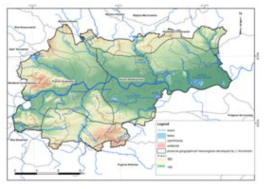
Figure 3.
A three-level hierarchical structure of the characteristics of the parameters that represent urban flood exposure.
Figure 3.
A three-level hierarchical structure of the characteristics of the parameters that represent urban flood exposure.
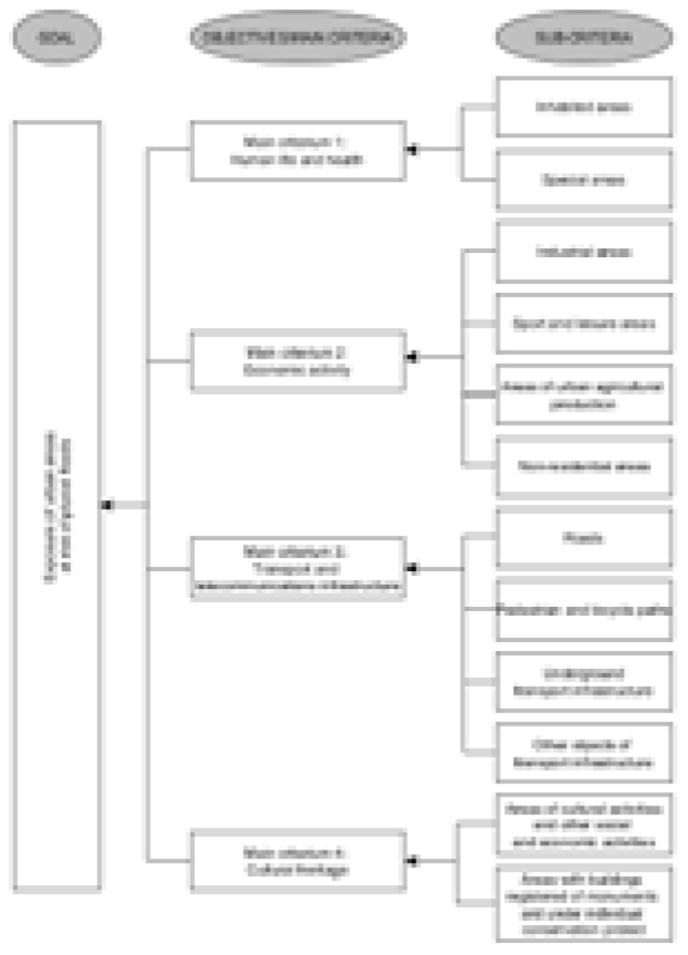
Figure 4.
The spatial distribution of the E_KG1 index (“Human life and health”) in Krakow.
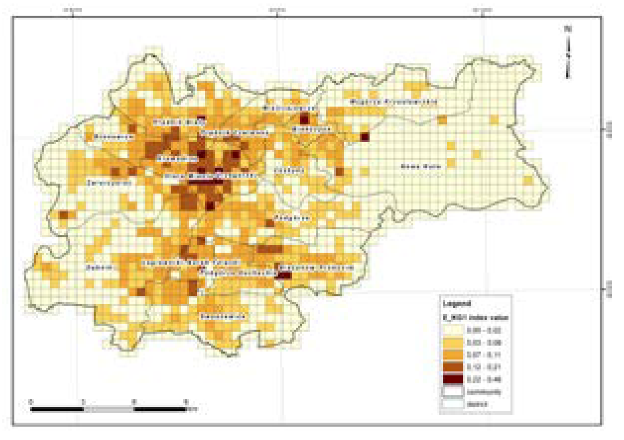
Figure 5.
The spatial distribution of the E_KG2 index (“Economic activity”) in Krakow.
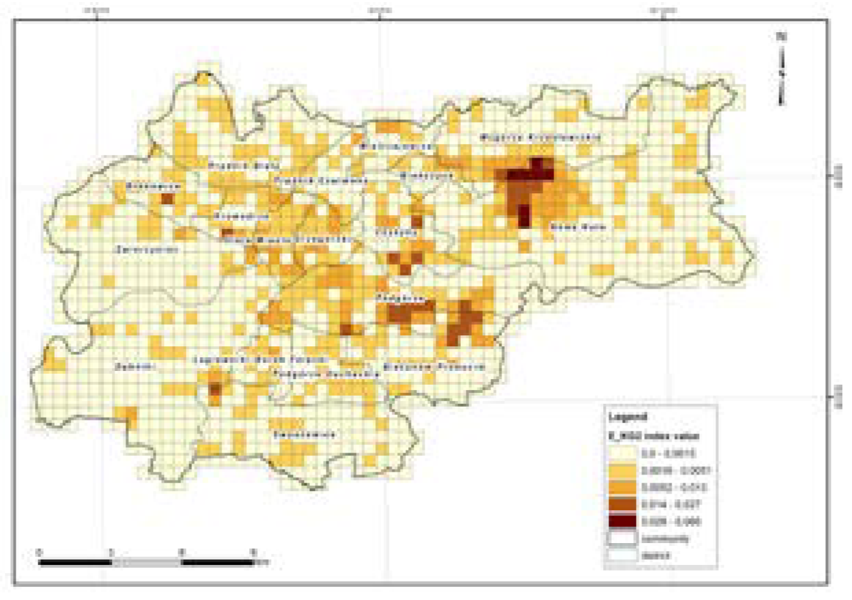
Figure 6.
The spatial distribution of the E_KG3 index (“Transport and telecommunications infrastructure”) in Krakow.
Figure 6.
The spatial distribution of the E_KG3 index (“Transport and telecommunications infrastructure”) in Krakow.
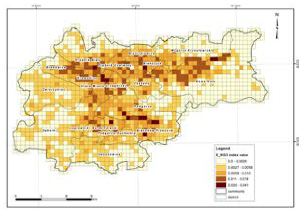
Figure 7.
The spatial distribution of the E_KG4 index (“Transport and telecommunications infrastructure”) in Krakow.
Figure 7.
The spatial distribution of the E_KG4 index (“Transport and telecommunications infrastructure”) in Krakow.
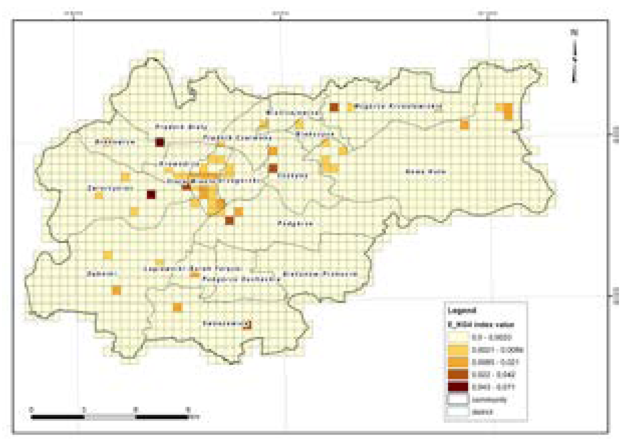
Figure 8.
The spatial distribution of integrated exposure index in Krakow.
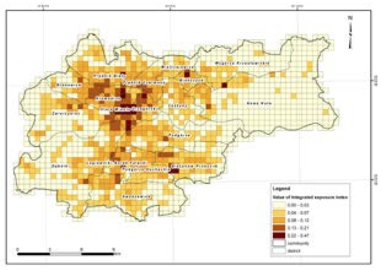
Table 1.
The fundamental scale of absolute numbers [24].
Table 1.
The fundamental scale of absolute numbers [24].
| Intensity of importance | Definition | Explanation |
|---|---|---|
| 1 | Equal importance | Two activities contribute equally to the objective |
| 3 | Moderate importance | Experience and judgement slightly favour one activity over another |
| 5 | Strong importance | Experience and judgement strongly favour one activity over another |
| 7 | Very strong or demonstrated importance | An activity is favoured very strongly over another; its dominance demonstrated in practice |
| 9 | Extreme importance | The evidence favouring one activity over another is of the highest possible order of affirmation |
Table 2.
Pairwise comparison matrix for the main criteria.
| Pairwise comparison matrix | KG1 | KG2 | KG3 | KG4 |
|---|---|---|---|---|
| KG1 | 1,000 | 8,002 | 7,348 | 7,393 |
| KG2 | 0,125 | 1,000 | 1,260 | 1,070 |
| KG3 | 0,136 | 0,794 | 1,000 | 0,742 |
| KG4 | 0,135 | 0,935 | 1,348 | 1,000 |
| Sum | 1,396 | 10,731 | 10,956 | 10,205 |
Table 3.
Normalization matrix for the main criteria.
| Normalization matrix | KG1 | KG2 | KG3 | KG4 | Priority vectors |
|---|---|---|---|---|---|
| KG1 | 0,716 | 0,746 | 0,671 | 0,724 | 0,7143 |
| KG2 | 0,090 | 0,093 | 0,115 | 0,105 | 0,1008 |
| KG3 | 0,097 | 0,074 | 0,091 | 0,073 | 0,0838 |
| KG4 | 0,097 | 0,087 | 0,123 | 0,098 | 0,1013 |
C.R. = 0,06 %.
Table 4.
Pairwise comparison matrix for the sub-criteria with respect to the main criterion – KG1.
| Pairwise comparison matrix | KC1-1 | KC1-2 |
|---|---|---|
| KC1-1 | 1,000 | 0,553 |
| KC1-2 | 1,809 | 1,000 |
| Sum | 2,809 | 1,553 |
Table 5.
Normalisation matrix for the sub-criteria with respect to main criterion – KG1.
| Normalization matrix | KC1-1 | KC1-2 | Priority vectors |
|---|---|---|---|
| KC1-1 | 0,356 | 0,356 | 0,356 |
| KC1-2 | 0,644 | 0,644 | 0,644 |
C.R. = 0.0.
Table 6.
Pairwise comparison matrix for the sub-criteria with respect to the main criterion – KG2.
| Pairwise comparison matrix | KC2-1 | KC2-2 | KC2-3 | KC2-4 |
|---|---|---|---|---|
| KC2-1 | 1,000 | 5,357 | 4,718 | 4,333 |
| KC2-2 | 0,187 | 1,000 | 0,804 | 1,070 |
| KC2-3 | 0,212 | 1,244 | 1,000 | 1,619 |
| KC2-4 | 0,231 | 0,858 | 0,618 | 1,000 |
| Sum | 1,630 | 8,459 | 7,140 | 8,022 |
Table 7.
Normalisation matrix for the sub-criteria with respect to main criterion – KG2.
| Normalization matrix | KC2-1 | KC2-2 | KC2-3 | KC2-4 | Priority vectors |
|---|---|---|---|---|---|
| KC2-1 | 0,613 | 0,633 | 0,661 | 0,540 | 0,612 |
| KC2-2 | 0,115 | 0,118 | 0,113 | 0,133 | 0,120 |
| KC2-3 | 0,130 | 0,147 | 0,140 | 0,202 | 0,155 |
| KC2-4 | 0,142 | 0,101 | 0,087 | 0,125 | 0,114 |
C.R. = 0,3%.
Table 8.
Pairwise comparison matrix for the sub-criteria with respect to the main criterion – KG3.
| Pairwise comparison matrix | KC3-1 | KC3-2 | KC3-3 | KC3-4 |
|---|---|---|---|---|
| KC3-1 | 1,000 | 5,593 | 1,293 | 0,971 |
| KC3-2 | 0,179 | 1,000 | 0,215 | 0,187 |
| KC3-3 | 0,774 | 4,651 | 1,000 | 0,733 |
| KC3-4 | 1,029 | 5,357 | 1,364 | 1,000 |
| Sum | 2,982 | 16,601 | 3,872 | 2,891 |
Table 9.
Normalisation matrix for the sub-criteria with respect to main criterion – KG3.
| Normalization matrix | KC3-1 | KC3-2 | KC3-3 | KC3-4 | Priority vectors |
|---|---|---|---|---|---|
| KC3-1 | 0,335 | 0,337 | 0,334 | 0,336 | 0,336 |
| KC3-2 | 0,060 | 0,060 | 0,056 | 0,065 | 0,060 |
| KC3-3 | 0,260 | 0,280 | 0,258 | 0,254 | 0,263 |
| KC3-4 | 0,345 | 0,323 | 0,352 | 0,346 | 0,342 |
C.R. = 0,2%.
Table 10.
Pairwise comparison matrix for the sub-criteria with respect to the main criterion – KG4.
| Pairwise comparison matrix | KC4-1 | KC4-2 |
|---|---|---|
| KC4-1 | 1,000 | 0,417 |
| KC4-2 | 2,268 | 1,000 |
| Sum | 3,268 | 1,417 |
Table 11.
Normalisation matrix for the sub-criteria with respect to main criterion – KG4.
| Normalization matrix | KC4-1 | KC4-2 | Priority vectors |
|---|---|---|---|
| KC4-1 | 0,306 | 0,294 | 0,300 |
| KC4-2 | 0,694 | 0,706 | 0,700 |
C.R. = 0.0.
Table 12.
Final priority vector for the main criteria.
| Main criteria | Priorities | Rank |
|---|---|---|
| Human life and health, KG1 | 0,7143 | 1 |
| Economic activity, KG2 | 0,1008 | 3 |
| Transport and telecommunications infrastructure, KG3 | 0,0838 | 4 |
| Cultural heritage, KG4 | 0,1013 | 2 |
Table 13.
Priority vectors and ranking of the sub-criteria given each main criterion.
| Main criteria |
Sub-criteria | Local weights |
Global weights |
Local ranking |
Global ranking |
|
|---|---|---|---|---|---|---|
| KG1 | KC1-1 | Inhabited areas | 0,356 (36%) |
0,254 (25%) |
2 | 2 |
| KC1-2 | Special areas | 0,644 (64%) |
0,460 (46%) |
1 | 1 | |
| KG2 | KC2-1 | Industrial areas | 0,612 (61%) |
0,062 (6%) |
1 | 4 |
| KC2-2 | Sports and leisure areas | 0,120 (12%) |
0,012 (1%) |
3 | 10 | |
| KC2-3 | Areas of urban agricultural production | 0,155 (16%) |
0,016 (2%) |
2 | 9 | |
| KC2-4 | Non-residential areas | 0,114 (11%) |
0,011 (1%) |
4 | 11 | |
| KG3 | KC3-1 | Roads | 0,336 (34%) |
0,028 (3%) |
2 | 7 |
| KC3-2 | Pedestrian and bicycle paths | 0,060 (6%) |
0,005 (1%) |
4 | 12 | |
| KC3-3 | Underground transport infrastructure | 0,263 (26%) |
0,022 (2%) |
3 | 8 | |
| KC3-4 | Other objects of transport infrastructure | 0,342 (34%) |
0,029 (3%) |
1 | 6 | |
| KG4 | KC4-1 | Areas of cultural activities and other social and economic activities | 0,300 (30%) |
0,030 (3%) |
1 | 5 |
| KC4-2 | Areas with buildings registered of monuments and under individual conservation protect | 0,700 (70%) |
0,071 (7%) |
2 | 3 |
Table 14.
The value of the consistency ratio (C.R.) for aggregated experts' judgments of the main criteria (KG1-4) and sub-criteria (KG1, KG2, KG3, KG4).
Table 14.
The value of the consistency ratio (C.R.) for aggregated experts' judgments of the main criteria (KG1-4) and sub-criteria (KG1, KG2, KG3, KG4).
| Main criterion symbol/ Sub-criterion symbol |
Consistency ratio [%] |
|---|---|
| KG1-4 | 0,6 |
| KG1 | 0,0 |
| KG2 | 0,3 |
| KG3 | 0,2 |
| KG4 | 0,0 |
Table 15.
The graphical interpretation of the exposure level.
| Colour | Exposure level |
|---|---|
| None or very small | |
| Small | |
| Medium | |
| High | |
| Very high |
Disclaimer/Publisher’s Note: The statements, opinions and data contained in all publications are solely those of the individual author(s) and contributor(s) and not of MDPI and/or the editor(s). MDPI and/or the editor(s) disclaim responsibility for any injury to people or property resulting from any ideas, methods, instructions or products referred to in the content. |
© 2023 by the authors. Licensee MDPI, Basel, Switzerland. This article is an open access article distributed under the terms and conditions of the Creative Commons Attribution (CC BY) license (http://creativecommons.org/licenses/by/4.0/).
Copyright: This open access article is published under a Creative Commons CC BY 4.0 license, which permit the free download, distribution, and reuse, provided that the author and preprint are cited in any reuse.


