Submitted:
25 April 2022
Posted:
26 April 2022
Read the latest preprint version here
Abstract
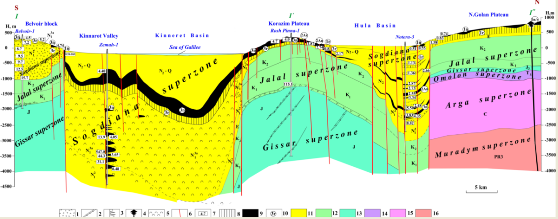
The easternmost Mediterranean is a distinct transition zone from the ocean to the continent located at the junction between the largest Earth's lithospheric segments: Eurasian and African. The methodology of paleomagnetic mapping of such transition zones is based on integrating the mapping techniques for both continental and oceanic platforms: paleomagnetic reconstructions, results of radiometric dating of magnetized rocks, tectonic-structural reconstructions, biogeography, and utilization of the results of various geophysical surveys. The geodynamic-paleomagnetic mapping makes it possible to reveal the multilevel structural heterogeneity and display complex elements of the geodynamics of different ages inherent in this transition zone. Northern Israel is obviously the most complex area in the easternmost Mediterranean. For the combined paleomagnetic mapping, well-studied paleomagnetically and radiometrically areas were selected: (1) the Carmel area, (2) the Atlit area (internal part of the Carmel area), (3) the Sea of Galilee with the adjoining zones (primarily, the Kinnarot Valley), and (4) the area of the Hula Basin with adjacent areas of the Golan Plateau, Hermon Mt., and Galilea uplift. The constructed paleomagnetic profiles for the Carmel area (on the top of the accumulative surface of the Lower Cretaceous traps), and the Kinnarot Valley – Sea of Galilee – Hula Basin, evidently indicate the complex history of the paleogeodynamic evolution of the region. These studies demonstrate the effectiveness of paleomagnetic mapping interated with paleomagnetic profiling, which crosses these geologically complex areas.
Keywords:
paleomagnetic mapping
; paleomagnetic profiling
; radiometric dating
; tectonic-structural inter-pretation
; integrated study
Copyright: This open access article is published under a Creative Commons CC BY 4.0 license, which permit the free download, distribution, and reuse, provided that the author and preprint are cited in any reuse.


