Preprint Article Version 1 Preserved in Portico This version is not peer-reviewed

UAV-based Survey of Glaciers in Himalayas: Opportunities and Challenges

Version 1 : Received: 27 February 2020 / Approved: 28 February 2020 / Online: 28 February 2020 (13:34:22 CET)

A peer-reviewed article of this Preprint also exists.

Ramsankaran, R., Navinkumar, P.J., Dashora, A. et al. UAV-Based Survey of Glaciers in Himalayas: Challenges and Recommendations. J Indian Soc Remote Sens 49, 1171–1187 (2021). https://doi.org/10.1007/s12524-020-01300-7 Ramsankaran, R., Navinkumar, P.J., Dashora, A. et al. UAV-Based Survey of Glaciers in Himalayas: Challenges and Recommendations. J Indian Soc Remote Sens 49, 1171–1187 (2021). https://doi.org/10.1007/s12524-020-01300-7

Abstract

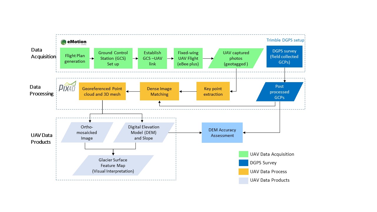
Unmanned Aerial Vehicle (UAV) based remote sensing (RS) studies in glaciology are mainly focusing on obtaining accurate high-resolution data from UAV images. Studies for identifying and minimising the challenges faced during the UAV-based RS data acquisition survey on inaccessible and harsh terrains of mountain glaciers is limited. This study aims to examine the practical challenges faced during UAV surveys of glaciers and derive strategies to minimize them. To the authors' knowledge, this is the first study that addresses such problems over the Himalayan region. Here, the UAV surveys were conducted using a fixed-wing commercial-grade off-the-shelf UAV (eBee plus, SenseFly) on three glacier sites (East Rathong, Hamtah and Panchinala-A) located in different zones and climate regimes lying within the Indian part of Himalayas. From UAV collected photos, the study was able to generate ultra-high-resolution ortho-mosaicked images and Digital Elevation Models (DEMs) at 0.1m GSD. UAV-derived DEMs was able to achieve vertical (horizontal) accuracy of 0.45 and 0.21 m (0.15 and 0.1 m) with 3 and 6 ground control points (GCPs) for an area of 0.75 km2 and 1.38 km2. Accuracy assessment of UAV DEMs generated with and without GCPs indicate that GCPs are must to obtain decimetre level accurate DEM especially on glaciers with steep-valleyed terrains. The utility of the obtained ultra-high-resolution ortho-mosaicked images was demonstrated by generating glacier surface feature maps. Based on the challenges observed during UAV surveys, the study identifies and recommends best-suited locations on a glacier and its adjacent regions for conducting UAV surveys efficiently in the glaciated terrain of Himalayas and possibly beyond. Recommendations reported in this article shall minimise the challenges faced and involved risks for data acquisition and thus enable UAVs to cover more glaciated area successfully.

Keywords

Digital Elevation Models; ortho-mosaicked images; glacier; remote sensing; Unmanned Aerial Vehicle

Subject

Environmental and Earth Sciences, Remote Sensing

Comments (4)

Comment 1
Received: 4 March 2020
Commenter: Suresh
The commenter has declared there is no conflict of interests.
Comment: I would like to know how to get permissions from different departments in West Sikkim to carry UAVs to Rathong glacier.

Moreover in India UAVs are not legal during the study period mentioned. So any special permission is required to carry UAV for research purpose is obtained? Please share, it will be helpful.

Thank you
+ Respond to this comment
Response 1 to Comment 1
Received: 8 March 2020
Commenter:
The commenter has declared there is no conflict of interests.
Comment: UAV operations are legal in India otherwise, we could have not imported it.
You need to get permission for research purpose.
Contact me through email for further details.
Response 2 to Comment 1
Received: 10 March 2020
The commenter has declared there is no conflict of interests.
Comment: As a general public comment I would like to mention below points.

I have applied for DGCA approvals to use UAVs for research purposes. DGCA unveiled its policy for operating drones in the country only in December 2018.

It was mentioned in the paper that in east Rathong, survey was carried out during Oct 2017 and in Hamtaah during Oct 2018.

According to the new list of regulations released by the DGCA, an exception can be made for micro drones flying upto 200 feet above the ground in well-lit conditions. The fixed wing UAV shown in figure 3 is not under micro drones category. Also it was mentioned it was flying at 170m above ground level. These points raise the ambiguity on UAV application with proper permissions during Oct 2017 & Oct 2018.

During Oct 2017 & Oct 2018, the drones were not legal in India.
Comment 2
Received: 11 March 2020
Commenter:
The commenter has declared there is no conflict of interests.
Comment: In Dec 2018 only, the UAV policy came into effect. Before that there is no policy but it does not mean UAV operation is illegal. If it is not legal, how come we could import it with due permissions.
+ Respond to this comment

We encourage comments and feedback from a broad range of readers. See criteria for comments and our Diversity statement.

Leave a public comment
Send a private comment to the author(s)
* All users must log in before leaving a comment
Views 0
Downloads 0
Comments 4
Metrics 0


×
Alerts
Notify me about updates to this article or when a peer-reviewed version is published.
We use cookies on our website to ensure you get the best experience.
Read more about our cookies here.