Submitted:
19 October 2018
Posted:
19 October 2018
You are already at the latest version
Abstract
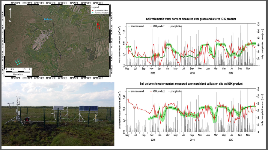
Soil moisture (SM) plays an essential role in environmental studies related to wetlands, an ecosystem sensitive to climate change. Hence, there is the need for its constant monitoring. SAR (Synthetic Aperture Radar) satellite imagery is the only mean to fulfill this objective regardless of the weather. The objective of the study was to develop the methodology for SM retrieval under wetland vegetation using Sentinel-1 (S-1) satellite data. The study was carried out during the years 2015–2017 in the Biebrza Wetlands, situated in northeastern Poland. At the Biebrza Wetlands, two Sentinel-1 validation sites were established, covering grassland and marshland biomes, where a network of 18 stations for soil moisture measurement was deployed. The sites were funded by the European Space Agency (ESA), and the collected measurements are available through the International Soil Moisture Network (ISMN). The NDVI (Normalized Difference Vegetation Index) was derived from the optical imagery of a MODIS (Moderate Resolution Imaging Spectroradiometer) sensor onboard the Terra satellite. The SAR data of the Sentinel-1 satellite with VH (vertical transmit and horizontal receive) and VV (vertical transmit and vertical receive) polarization were applied to soil moisture retrieval for a broad range of NDVI values and soil moisture conditions. The new methodology is based on research into the effect of vegetation on backscatter () changes under different soil moisture and vegetation (NDVI) conditions. It was found that the state of the vegetation may be described by the difference between VH and VV, or the ratio of VV/VH, as calculated from the Sentinel-1 images. The most significant correlation coefficient for soil moisture was found for data that was acquired from the ascending tracks of the Sentinel-1 satellite, characterized by the lowest incidence angle, and SM at a depth of 5 cm. The study demonstrated that the use of the inversion approach, which was applied to the new developed models and includes the derived indices based on S-1, allowed the estimation of SM for peatlands with reasonable accuracy (RMSE ~ 10 vol. %). Due to the temporal frequency of the two S-1 satellites’ (S-1A and S-1B) acquisitions, it is possible to monitor SM changes every six days. The conclusion drawn from the study emphasizes a demand for the derivation of specific soil moisture retrieval algorithms that are suited for wetland ecosystems, where soil moisture is several times higher than in agricultural areas.
Keywords:
Sentinel-1 backscatter
; polarization
; Terra MODIS
; NDVI
; soil moisture
Copyright: This open access article is published under a Creative Commons CC BY 4.0 license, which permit the free download, distribution, and reuse, provided that the author and preprint are cited in any reuse.


