Preprint Article Version 1 Preserved in Portico This version is not peer-reviewed

A Remote Sensing Approach to Subsidence and Vegetation Degradation in a Reclaimed Mine Area

Version 1 : Received: 2 November 2017 / Approved: 2 November 2017 / Online: 2 November 2017 (15:01:03 CET)

A peer-reviewed article of this Preprint also exists.

Padmanaban, R.; Bhowmik, A.K.; Cabral, P. A Remote Sensing Approach to Environmental Monitoring in a Reclaimed Mine Area. ISPRS Int. J. Geo-Inf. 2017, 6, 401. Padmanaban, R.; Bhowmik, A.K.; Cabral, P. A Remote Sensing Approach to Environmental Monitoring in a Reclaimed Mine Area. ISPRS Int. J. Geo-Inf. 2017, 6, 401.

Abstract

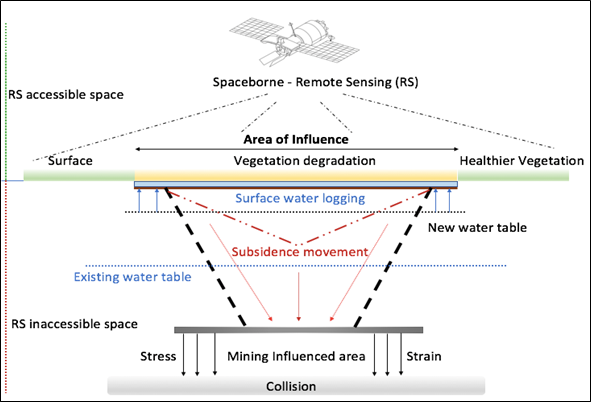
Mining for resources extraction may lead to several geological and associated environmental changes due to ground movements, collision with mining cavities and deformation of aquifers. Geological changes may continue in a reclaimed mine area, and the deformed aquifers may entail a breakdown of substrates and an increase in ground water tables, which may cause surface area inundation. Consequently, a reclaimed mine area may experience surface area collapse, i.e. subsidence, and degradation of vegetation health. Thus, monitoring short-term landscape dynamics in a reclaimed mine area may provide important information on the long-term geological and environmental impacts of mining activities. We studied landscape dynamics in Kirchheller Heide, Germany, which experienced extensive soil movement due to longwall mining without stowing, using Landsat imageries between 2013 and 2016. A Random Forest image classification technique was applied to analyse land-use and land-cover dynamics and the growth of wetland areas was assessed using a Spectral Mixture Analysis (SMA). We also analyzed the changes in vegetation health using a Normalized Difference Vegetation Index (NDVI). We observed a 19.9% growth of wetland area within the four years with 87.2% of growth in the coverage of two major waterbodies in the reclaimed mine area. NDVI values indicate that 66.5% of the vegetation of the study area was degraded due to changes in ground water tables and surface flooding. Our results inform environmental management and mining reclamation authorities about the subsidence spots and priority mitigation areas from land surface and vegetation degradation in Kirchheller Heide.
Keywords

Mining; Mine reclamation; Land cover change; Vegetation health; NDVI Post-mining; SMA; Random forest classification; Remote Sensing

Subject

Environmental and Earth Sciences, Environmental Science

Comments (3)

Importance: How significant is the paper to the field?
Outstanding/highlight paper
100%
Significant contribution
0%
Incremental contribution
0%
No contribution
0%
Soundness of evidence/arguments presented:
Conclusions well supported
100%
Most conclusions supported (minor revision needed)
0%
Incomplete evidence (major revision needed)
0%
Hypothesis, unsupported conclusions, or proof-of-principle
0%
Comment 1
Received: 2 November 2017
Commenter: Alex
The commenter has declared there is no conflict of interests.
Comment: High standard article, I recommend to publish this paper. I congrats the authors
+ Respond to this comment
Comment 2
Received: 3 November 2017
Commenter: Edzer
The commenter has declared there is no conflict of interests.
Comment: High contribution
+ Respond to this comment
Comment 3
Received: 3 November 2017
Commenter: Oraib Almegdadi
The commenter has declared there is no conflict of interests.
Comment: Interesting, clear and good paper ..
Recommend for publishing
+ Respond to this comment

We encourage comments and feedback from a broad range of readers. See criteria for comments and our Diversity statement.

Leave a public comment
Send a private comment to the author(s)
* All users must log in before leaving a comment
Views 0
Downloads 0
Comments 3
Metrics 0


×
Alerts
Notify me about updates to this article or when a peer-reviewed version is published.
We use cookies on our website to ensure you get the best experience.
Read more about our cookies here.