
Submitted:
15 September 2016
Posted:
16 September 2016
You are already at the latest version
Abstract
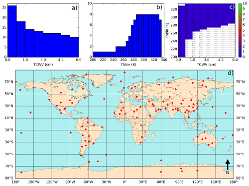
Land Surface Temperature (LST) is routinely retrieved from remote sensing instruments using semi-empirical relationships between top of atmosphere (TOA) radiances and LST, using ancillary data such as total column water vapor or emissivity. These algorithms are calibrated using a set of forward radiative transfer simulations that return the TOA radiances given the LST and the thermodynamic profiles. The simulations are done in order to cover a wide range of surface and atmospheric conditions and viewing geometries. This work analyses calibration strategies, considering some of the most critical factors that need to be taken into account when building a calibration dataset, covering the full dynamic range of relevant variables. A sensitivity analysis of split-windows and single channel algorithms revealed that selecting a set of atmospheric profiles that spans the full range of surface temperatures and total column water vapor combinations that are physically possible seems beneficial for the quality of the regression model. However, the calibration is extremely sensitive to the low-level structure of the atmosphere indicating that the presence of atmospheric boundary layer features such as temperature inversions or strong vertical gradients of thermodynamic properties may affect LST retrievals in a non-trivial way. This article describes the criteria established in the EUMETSAT Land Surface Analysis – Satellite Application Facility to calibrate its LST algorithms applied both for current and forthcoming sensors.
Keywords:
land surface temperature
; thermal infrared
; calibration
; generalized split-window
; mono-window
; database
; radiative transfer
Copyright: This open access article is published under a Creative Commons CC BY 4.0 license, which permit the free download, distribution, and reuse, provided that the author and preprint are cited in any reuse.


