

Submitted:
15 November 2026
Posted:
17 November 2026
You are already at the latest version
Abstract
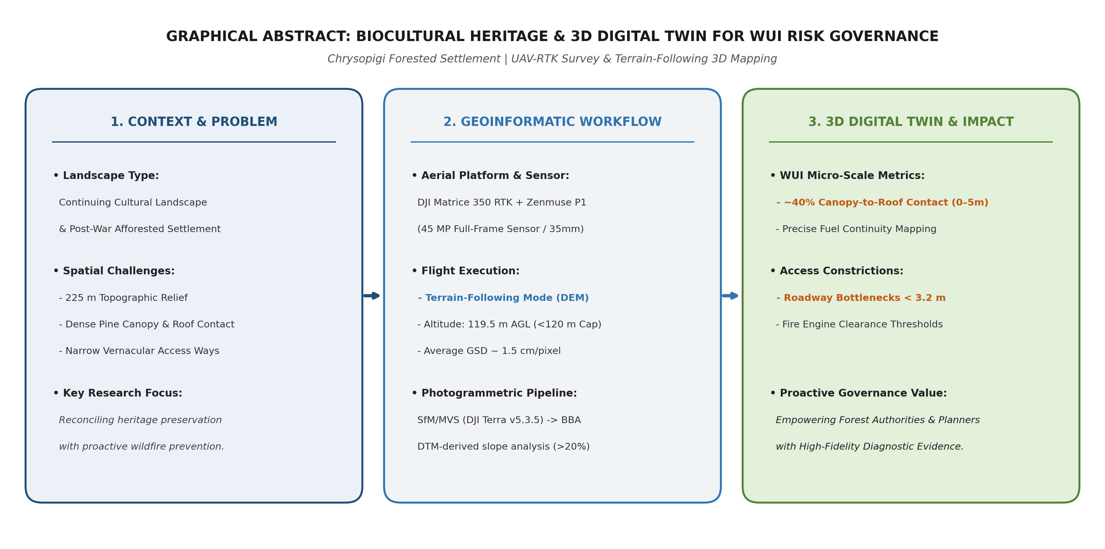
In an era of intensifying climate crisis, rural abandonment, and catastrophic wildfires, the historical interplay between anthropogenic settlements and forested environments requires a paradigm shift. Mountain forest settlements represent dynamic cultural landscapes where biocultural heritage has actively shaped ecosystem evolution. However, modern conservation frequently lacks both historical context and high-precision spatial documentation to support proactive management. This study investigates the mountain forest settlement of Chrysopigi (Serres, Northern Greece) as a biocultural heritage asset, bridging historical forest governance with advanced geoinformatics. Developed in close collaboration with the local Forest Directorate of Serres, the research utilizes institutional archival records to trace the settlement’s genesis and the historical drivers behind the initial afforestation and watershed management of the Chrysopigi hill. Complementing this archival baseline, an aerial survey was conducted using a Real-Time Kinematic (RTK)-enabled Unmanned Aerial Vehicle (UAV) equipped with a high-resolution, full-frame photogrammetric sensor. Operating under a terrain-following mode to maintain a constant flight altitude, the survey produced high-resolution 2D orthomosaics and digital surface models (DSM) with an average ground sampling distance of approximately 1.5 cm. This spatial framework accurately documents the surviving vernacular built fabric, historical pathways, and the critical wildland-urban interface (WUI) where vegetation biomass borders human structures. By contextualizing high-resolution digital twins within historical forestry records, the study demonstrates that recognizing forest settlements as biocultural heritage operationalizes sustainable stewardship. This integrated methodology provides forestry authorities and spatial planners with an empirical tool for targeted wildfire prevention, historical landscape preservation, and long-term climate resilience.
Keywords:
biocultural heritage
; cultural landscapes
; UAV-RTK photogrammetry
; 3D digital twins
; forest history
; forest governance
; wildland-urban interface (WUI)
; sustainable landscape management
1. Introduction
The accelerating global climate crisis has fundamentally destabilized temperate and Mediterranean forest ecosystems, driving an unprecedented surge in wildfire frequency, intensity, and spatial extent. In Southern Europe, this ecological vulnerability is acutely compounded by widespread rural depopulation and the progressive abandonment of traditional agro-pastoral practices over recent decades [1,2]. The resulting cessation of historical land-use regimes has led to unchecked biomass accumulation, fuel continuity across expansive landscapes, and the uncontrolled densification of the wildland-urban interface (WUI) [3,4]. Consequently, forested environments face a dual threat: ecological collapse induced by recurring mega-fires on the one hand, and the irreversible erosion of traditional cultural landscapes on the other. Conventional preservationist models that treat forests as static, pristine wilderness separated from human activity have increasingly proven inadequate in mitigating these interrelated socio-ecological risks [5].
Addressing these contemporary challenges demands a decisive paradigm shift toward recognizing forested landscapes and their embedded mountain settlements as continuing cultural landscapes and repositories of biocultural heritage. Far from being unmanaged natural regimes, many mountainous forest matrices are historical socio-ecological constructs, profoundly shaped by long-standing human stewardship, systematic afforestation, watershed management, and vernacular architectural traditions. However, the successful operationalization of this holistic perspective in spatial planning and forest governance remains severely constrained by a critical documentation gap. Sustainable conservation requires not only historical contextualization through institutional memory and archival forest records, but also high-precision, multi-dimensional spatial mapping capable of capturing the intricate physical interactions between built structures and surrounding vegetative fuels [6,7].
Building upon this socio-ecological tension, the central research question guiding this investigation is: Can mountain forests and their embedded settlements be systematically recognized and managed as continuing cultural landscapes, and how can high-resolution geoinformatic baselines operationalize their long-term resilience against accelerating climate pressures?
To address this overarching inquiry, this study pursues four primary objectives. First, it aims to delineate the criteria under which mountain forest settlements can be classified as biocultural heritage assets, grounding the theoretical framework of continuing cultural landscapes in the administrative and archival records of the Forest Directorate of Serres. Second, it contextualizes the historical anthropogenic evolution of Chrysopigi, examining original afforestation and watershed stabilization interventions to demonstrate that the contemporary forest matrix is an actively constructed socio-ecological system rather than pristine wilderness. Third, it seeks to establish a high-accuracy spatial baseline through survey-grade UAV-RTK photogrammetry, evaluating how ultra-high-resolution 2D orthomosaics and 3D digital surface models capture both the heterogeneous built fabric and the micro-topographical layout of the settlement. Finally, it aims to operationalize these geoinformatic outputs within a proactive landscape resilience strategy, demonstrating how fine-scale spatial mapping of fuel continuity at the wildland-urban interface (WUI) reconciles cultural heritage conservation with actionable, preventive forest management.
The remainder of this paper is structured as follows. Section 2 presents a comprehensive literature review on continuing cultural landscapes, biocultural diversity, and the integration of survey-grade geoinformatics in wildland-urban interface (WUI) risk governance. Section 3 outlines the materials and methods, detailing the study area of Chrysopigi, the archival evidence provided by the Forest Directorate of Serres, the UAV-RTK data acquisition workflow, and the photogrammetric processing pipeline. Section 4 presents the empirical results, focusing on the metric baseline accuracy, the spatial documentation of structures and pathways, and the micro-topographical modeling of fuel continuity at the wildland-urban interface. Section 5 discusses the implications of recognizing forest settlements as biocultural assets for landscape resilience, proactive wildfire management, and participatory stewardship, while acknowledging technical limitations. Finally, Section 6 summarizes the main conclusions and outlines pathways for future research.
2. Literature Review
2.1. Continuing Cultural Landscapes and Sustainable Forest Conservation
Cultural landscapes are increasingly understood as dynamic socio-ecological systems shaped by interactions between human activities, ecological processes, and historical land-use practices. Continuing cultural landscapes are particularly significant because their historical functions and relationships between communities and the environment remain recognizable despite ongoing transformations. Their conservation therefore requires approaches that integrate ecological management with the preservation of cultural and historical characteristics. Agnoletti [6] emphasized that traditional rural landscapes often possess ecological and cultural values that conventional nature conservation approaches overlook. This is particularly relevant in Mediterranean regions, where agricultural activities, grazing, afforestation, and forest management have historically shaped landscape structure and biodiversity. The abandonment of traditional land-use practices may contribute to vegetation encroachment and increased fuel connectivity, potentially intensifying wildfire hazards. Recent research has highlighted the importance of governance and local knowledge in sustaining these landscapes. Plieninger et al. [8], examining biocultural conservation systems across Mediterranean countries, demonstrated that community values, institutional arrangements, and traditional knowledge contribute to long-term landscape stewardship. These findings support conservation strategies that recognize forests as historically managed environments rather than exclusively natural ecosystems. For historically forested settlements such as Chrysopigi, this perspective emphasizes the importance of integrating archival forestry records with contemporary spatial documentation. Historical evidence of afforestation, watershed management, and settlement development can reveal the processes responsible for current landscape configurations, providing a foundation for conservation strategies that address both cultural continuity and environmental resilience.
2.2. Biocultural Diversity and Heritage Conservation
Biocultural diversity describes the interdependence of biological diversity, cultural practices, traditional knowledge, and human relationships with ecosystems. This perspective recognizes that ecological and cultural heritage frequently evolve together and should therefore be considered within integrated conservation frameworks. Hanspach et al. [9], through a systematic literature review, identified biocultural approaches as important frameworks for sustainability, emphasizing relationships between ecological knowledge, cultural values, and landscape stewardship. Similarly, Lukawiecki et al. [10] highlighted the need to translate biocultural concepts into operational conservation practices through appropriate governance mechanisms and interdisciplinary methods. Recent Mediterranean research further demonstrates the importance of these relationships. Plieninger et al. [8] identified the role of institutional rules, community values, and local knowledge in maintaining biocultural conservation systems. Reina Rozo [11] extended this perspective by examining how biocultural innovation can contribute to adaptive environmental management and sustainable futures. Biocultural heritage includes tangible elements, such as historical buildings, pathways, forest structures, and water-management infrastructure, alongside intangible dimensions including collective memory, traditional practices, and institutional knowledge. Consequently, its documentation requires the combination of historical investigation and spatial analysis. In Chrysopigi, the integration of archival forestry evidence with high-resolution three-dimensional mapping can support the interpretation of the settlement and surrounding woodland as interconnected cultural and ecological assets. This approach also provides a basis for balancing heritage preservation with contemporary vegetation management and wildfire prevention requirements.
2.3. Survey-Grade Geoinformatics and WUI Risk Governance
The wildland–urban interface (WUI), where settlements and wildland vegetation meet or intermingle, represents a critical area for wildfire risk assessment. Mediterranean WUI environments are particularly vulnerable due to complex terrain, combustible vegetation, dispersed settlements, and changing land-use practices. Recent studies have substantially advanced WUI mapping through remote sensing and geospatial analysis. Radeloff et al. [12] developed a global WUI mapping framework at 10 m resolution, while Chen et al. [13] demonstrated a 12.56% increase in global WUI areas between 1985 and 2020, revealing that a critical proportion of residential zones embedded in wildland matrices face severe, compounding wildfire hazards. European-scale research published in Landscape and Urban Planning [14] demonstrated the relationships between WUI distribution, settlement patterns, and socioeconomic characteristics, while municipal-scale mapping in Portugal [15] further highlighted the importance of spatial resolution and local building–vegetation configurations for wildfire exposure assessment.
Research has also increasingly focused on vegetation structure and settlement characteristics. Studies examining wildfire severity in Southern European WUI environments [16] and integrating hyperspectral imagery with forest inventory data [17] demonstrate the potential of spatial analysis for identifying hazardous configurations and prioritizing preventive interventions. Within this context, UAV photogrammetry provides important advantages for settlement-scale documentation. Structure-from-Motion (SfM) and multi-view stereopsis enable the production of detailed orthomosaics, dense point clouds, digital surface models, and textured 3D reconstructions. RTK-enabled UAV systems can improve georeferencing accuracy and reduce reliance on extensive ground-control networks, although independent validation remains necessary. Recent investigations using UAV-derived photogrammetric point clouds for Mediterranean forest fuel estimation [18] demonstrate the potential of high-resolution three-dimensional information for vegetation characterization. Such datasets can support the identification of buildings–vegetation proximity, canopy connectivity, topographic constraints, and historical access routes. However, dense vegetation and canopy occlusion limit the reliability of photogrammetric terrain reconstruction and detailed fuel characterization without supplementary field measurements. While global and regional mapping frameworks [12,13] provide indispensable macro-level policy perspectives, they inherently rely on moderate-resolution satellite imagery and broad spatial buffers. Consequently, these coarse-scale baselines cannot resolve micro-topographic slope variability, structural material vulnerabilities, or localized canopy-to-roof fuel continuity at the individual building-lot scale. For Chrysopigi, survey-grade UAV-RTK mapping provides a common spatial framework for documenting vernacular structures, historical pathways, forest vegetation, and the settlement’s WUI. These datasets can support localized assessment of spatial risk indicators and provide a baseline for future environmental monitoring and conservation planning.
2.4. Research Gap and Contribution
Existing research has established the importance of cultural landscape continuity, biocultural heritage, and advanced geospatial technologies for sustainable environmental management. Nevertheless, these research directions are frequently addressed separately. Cultural landscape studies primarily emphasize historical and socio-ecological relationships, while WUI investigations focus on vegetation characteristics, settlement exposure, and wildfire risk. The present study addresses this intersection by combining historical forestry records with high-resolution UAV-RTK photogrammetry in Chrysopigi, Greece. Its contribution lies in developing an integrated framework that interprets forest settlements as biocultural heritage assets while providing detailed spatial information for heritage documentation, vegetation proximity assessment, and preventive forest management. This approach supports the integration of cultural conservation and wildfire resilience within a shared, evidence-based landscape management framework.
3. Materials and Methods
3.1. Study Area and Cultural–Historical Context
The settlement of Chrysopigi is a semi-mountainous community in the Serres Prefecture, Northern Greece, situated on the western slopes of the Vrondou mountain range (600–650 m a.s.l., slopes ranging between 10% and 30%). Toponymically, the name "Chrysopigi" originates from the Greek words "chrysi" (golden) and "pigi" (spring), directly referencing a historical natural spring renowned for its clear, cool water. Although this hydrological source has since dried up, the preserved toponym retains the collective memory of the settlement’s foundational natural heritage. Located 12 km northwest of the city of Serres along the road leading to the Lailias Ski Center, Chrysopigi functions as a regional hub combining cultural touring with ecotourism, outdoor recreation (hiking, cycling, enduro trails), and seasonal residency. While its permanent population remains small (30 registered inhabitants in the 2021 census), the settlement experiences a substantial seasonal influx of residents during summer months. The site hosts various public and educational facilities, including youth camps, a municipal sports complex, infrastructure of the Chrysopigi Experimental Center (Hellenic Agricultural Organization - DIMITRA / Forest Research Institute of Thessaloniki), a forest nursery, forestry service buildings, a game breeding station, and a designated forest recreation site managed by the Forest Service.
Historically, the area was uninhabited prior to the post-World War II period (Figure 1). The terrain was steep, rugged, and unsuited for traditional agriculture, characterized by sparse scrubland (oaks, hornbeams, Christ’s thorn) and limited planted pines. However, its favorable microclimate made it an ideal retreat for vulnerable populations, particularly children with respiratory health conditions. Initial seasonal tenting gradually evolved into informal, lightweight structures, with vacationers actively planting shade trees (predominantly acacias and pines) (Figure 2). This grass-roots settlement growth led to the formation of the Chrysopigi Vacationers’ Association in 1956, whose founding statutes explicitly prioritized environmental protection, reforestation, and community solidarity (Figure 3).
The institutionalization of the settlement proceeded through key legal and administrative milestones: 1. Ministerial Decision 76243/8-7-1957 (Ministry of Agriculture): Granted 10.6 hectares of the Elaionas estate to the Chrysopigi Naturalist Association for establishing a summer residential settlement under strict public-benefit conditions.
2. Cooperative Era (1971–1984): Formation of a Building Cooperative in 1971 to systematically manage plot allocation, culminating in the formal approval of the Chrysopigi Town Plan in 1984. 3. Protective Forest Status (Prefectural Decision 377/04-03-1986): Designation of the surrounding pine forest matrices as protective forests across the torrent catchment basins of Kamenikia, Agioi Anargyroi, and Elaionas.
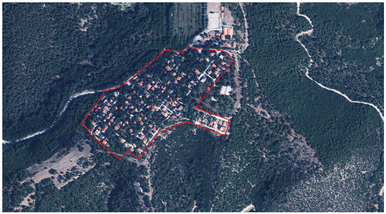
The contemporary landscape is dominated by dense pine stands resulting from systematic, artificial afforestation campaigns executed by the Forest Service between 1950 and 1955 to protect the downstream city of Serres from catastrophic flash flooding and soil erosion (Figure 5 and Figure 6). Consequently, the contemporary forest environment is not a pristine wilderness, but a directly constructed socio-ecological system shaped by decades of human interventions (afforestation, logging, grazing, wildfire suppression, and wildlife management). The radical socio-ecological transition of Chrysopigi—from an arid, rugged slope to a densely forested settlement—is documented through archival imagery and historical layout plans (Figure 4). The cultural significance of Chrysopigi lies precisely in this hybrid origin, demonstrating how anthropogenic necessity, institutional management, and community stewardship co-evolved into a resilient, living cultural landscape.
Figure 4.
The first map design of Chrysopigi (1957) (Courtesy of N. Christidis family). [19]
Figure 4.
The first map design of Chrysopigi (1957) (Courtesy of N. Christidis family). [19]
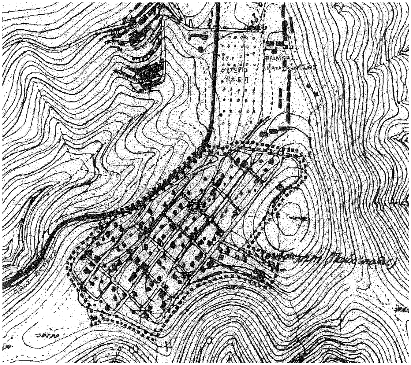
Figure 5.
Chrysopigi in 2007 (Archive of the Forest Directorate of Serres).
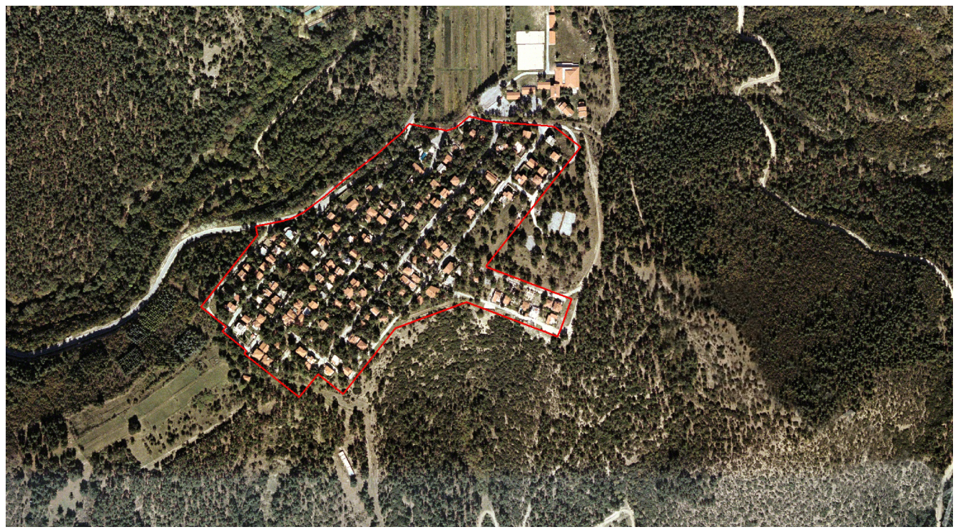
Figure 6.
Chrysopigi in 2015 (Archive of the Forest Directorate of Serres).
3.2. Data Acquisition: Survey Equipment, Flight Missions, and Field Protocol
Aerial surveying of the Chrysopigi forested settlement was conducted utilizing a survey-grade Unmanned Aerial Vehicle (UAV) platform, the DJI Matrice 350 RTK, coupled with a 45-megapixel full-frame (35.9 x 24.0 mm) DJI Zenmuse P1 photogrammetric camera equipped with a 35 mm fixed-focal-length lens and a mechanical global shutter. The platform’s onboard multi-frequency GNSS receiver operated in Real-Time Kinematic (RTK) mode, delivering centimeter-level exterior orientation positioning for each image capture and eliminating the systemic geometric drift commonly associated with steep, vegetated mountainous terrain.
Mission planning, waypoint generation, and flight execution were managed through the DJI Pilot 2 application. To maintain strict Visual Line of Sight (VLOS) regulations and mitigate radio frequency (RF) attenuation caused by the dense canopy and rugged topography, the survey area was partitioned into two distinct, interconnected flight blocks designed with an approximate 20% spatial overlap:
- Upper Block (High-Elevation Station): Executed from the highest topographic vantage point within the settlement, ensuring an unobstructed line of sight above the tree line and robust Command and Control (C2) link stability over the steep upper slopes.
- Lower Block (Plateau Station): Executed from an open, flatter clearing with a broad horizon, providing direct line-of-sight monitoring across the lower settlement edge and the adjacent forest boundary.
Both missions commenced with fully charged intelligent flight batteries (98% capacity indicated at the remote controller) after achieving a verified multi-constellation RTK home point lock. The operational parameters within the Area Route protocol were configured as follows:
- Altitude, Clearance, and Terrain Following: Flight altitude was set to 119.5 m (392 ft) Above Ground Level (AGL). To compensate for the steep 225 m topographic relief and adhere strictly to the legal ceiling of 120 m AGL for civil UAV operations, a Terrain Following (Terrain Awareness) flight mode was utilized, importing a digital elevation model (DEM) into the flight planner. This strategy maintained a constant sensor-to-ground distance, yielding a stable average Ground Sampling Distance (GSD) of approximately 1.5 cm/pixel across the entire slope. A safe takeoff altitude of 30.5 m (100 ft) was designated to prevent any collision hazard with mature forest canopies during the initial climb.
- Flight Kinematics and Coverage: The cruise speed was established at 33.5mph (15.0m/s), with a defined flight path course angle of 268. Imaging was executed in timed-interval mode with standard nadir orientation (custom angle disabled).
- Photogrammetric Overlap: To guarantee robust automated tie-point matching across the repetitive, textured forest canopy and irregular built structures, frontal (longitudinal) overlap was set at 80%, while side (lateral) overlap was maintained at 70%, with a zero margin along the defined boundary polygon.
- Vertical Accuracy Enhancement: The Elevation Optimization feature was activated. Upon completing each grid trajectory, the UAV automatically traversed to the centroid of the survey area, acquiring a sequence of oblique convergence images at varying pitch angles. This routine decoupled sensor interior orientation parameters (notably focal length and radial lens distortion) from vertical ground coordinates, suppressing doming deformations across the digital surface model.
- Safety Protocols: The failsafe return-to-home (RTH) routine was automated upon mission completion, ensuring safe recovery at the respective station.
A nadir acquisition strategy supplemented by automated central oblique convergence (Elevation Optimization) was deliberately favored over an exhaustive multi-camera oblique flight grid (such as smart oblique capture). This choice balanced survey-grade vertical accuracy with operational feasibility, mitigating substantial flight-time increases, battery logistics in rugged terrain, and oblique line-of-sight occlusions caused by the dense, mature tree canopies adjacent to the built structures.
The complete spatial layout of the dual-station survey and the associated flight parameters are schematically summarized in Figure 7.
3.3. Photogrammetric Reconstruction and Metric Baseline Documentation
Photogrammetric processing and spatial reconstruction were executed using DJI Terra Standard Edition (v5.3.5), an integrated Structure-from-Motion (SfM) and multi-view stereopsis (MVS) computational engine. The raw aerial image datasets collected across the two overlapping flight missions were co-registered into a unified photogrammetric project within the "General" reconstruction template, operating under a standalone high-performance computation architecture. The photogrammetric workflow comprised two main processing pipelines: aerial triangulation and multi-dimensional surface generation:
- Aerial Triangulation (AT) and Relative Orientation: Automated feature extraction and descriptor matching were conducted with the Feature Point Density parameterized to "High", enabling maximum keypoint identification across homogenous forest canopies and complex vernacular roof surfaces. In the absence of terrestrial ground control points (GCPs), bundle block adjustment (BBA) relied on high-precision camera exposure stations derived from the onboard RTK system. This direct georeferencing paradigm exploited dual-frequency GNSS positioning combined with the previously described nadir-and-oblique convergence geometry, mitigating non-linear vertical distortions across the rugged mountain terrain. While this direct georeferencing approach guarantees robust relative spatial alignment across the reconstructed surfaces, the absence of independent terrestrial checkpoints precludes the derivation of absolute Root Mean Square Error (RMSE) metrics, representing a recognized methodological constraint that will be addressed in future GNSS-RTK field audits.
- 2D Orthomosaic Generation: True orthomosaic reconstruction was configured under the dedicated "Mapping Scenarios" radiometric engine at full resolution (100% High Resolution). An intelligent hole-filling algorithm (Fill Hole Intelligently) was activated to reconstruct occluded ground corridors caused by dense vegetation, steep slopes, or shadowed façades. The output was exported as a seamless, high-resolution georeferenced raster in standard GeoTIFF format, establishing the spatial foundation for two-dimensional land-use and interface fuel characterization.
-
3D Mesh and Metric Digital Twin Reconstruction: Dense surface geometry was modeled at maximum resolution (100% High Quality) to reconstruct detailed architectural elements, vernacular stone wall alignments, and canopy contours. To reconcile structural geometric fidelity with operational computational efficiency, a mesh decimation ratio was applied, simplifying the polygon count by 50% while preserving prominent morphological breaklines and structural boundaries. The final textured 3D mesh was exported across multiple open and industry-standard geospatial formats:
- PLY and OBJ: For interoperability with general 3D spatial analysis, geographic information systems (GIS), and morphological modeling.
- FBX: Preserving texture coordinate mapping and materials for high-fidelity visualization.
- B3DM (Batched 3D Model): Supporting 3D Tiles streaming standards for interactive web-based visualization and participatory spatial governance platforms.
Furthermore, direct export compatibility with DJI Modify was enabled, allowing targeted topological and geometric refinement (e.g., manual surface cleaning, water-body leveling, and structural noise removal) without disrupting spatial georeferencing. Specialized exploratory outputs—including Gaussian Splatting, unmeshed point clouds, and raw raster digital elevation models (DEM)—were bypassed in this initial phase to prioritize the textured, metric polygonal mesh as the primary diagnostic digital twin of the settlement. To evaluate the algorithmic robustness of the photogrammetric reconstruction, an exploratory benchmark was conducted using Agisoft Metashape Professional (v2.3.1) under identical raw input imagery and spatial georeferencing parameters. The resulting textured 3D mesh generated by Metashape yielded comparable structural fidelity, surface continuity, and geometric alignment, with no discernible visual or topological discrepancies that warranted altering the computational workflow. Consequently, DJI Terra (v5.3.5) was retained as the primary photogrammetric suite due to two decisive operational advantages. First, it offers seamless hardware–software integration with the DJI Matrice 350 RTK and Zenmuse P1 sensor payload, facilitating native parsing of the camera’s high-precision RTK positional telemetry, IMU orientation metadata, and sensor-specific optical calibration profiles without intermediary coordinate or datum transformations. Second, and crucially for interdisciplinary spatial workflows, DJI Terra is natively integrated with the DJI Modify and DJI Viewer ecosystem. Because the resulting high-density textured 3D mesh approached approximately 4 GB in file size, direct peer-to-peer dissemination or localized visualization on non-specialized hardware posed severe logistical bottlenecks. The direct cloud-sharing capabilities native to DJI Modify enabled secure, web-based streaming of the multi-gigabyte digital twin. This eliminated the imperative to architect a dedicated, proprietary 3D streaming infrastructure, thereby allowing cross-disciplinary research team members and forest management stakeholders to inspect, annotate, and evaluate the spatial models in real time through standard web interfaces without local computational overhead.
3.4. Spatial Risk Assessment and Wildland-Urban Interface Workflow
The spatial expansion of residential settlements into mountainous forest matrices has established the Wildland-Urban Interface (WUI) as a primary zone of socio-ecological vulnerability. In Chrysopigi, complex geomorphology, dense vegetative fuel accumulation, and proximity to sensitive forest ecosystems create heightened exposure to natural hazards, particularly crown wildfires. Recognizing this vulnerability, local governance frameworks—including municipal emergency protocols for organized preventive evacuation—mandate fine-scale spatial risk assessment to safeguard both human infrastructure and ecological assets. To operationalize risk assessment across this complex terrain, this study establishes an integrated Geographic Information System (GIS) and spatial multi-criteria decision analysis (MCDA) workflow, fed directly by the survey-grade 2D orthomosaics and 3D digital surface models derived in Section 3.2 and 3.3. The methodological workflow unfolds across four analytical modules:
- 1. Topographic Vector Analysis: Derivation of high-resolution terrain metrics—specifically slope steepness (>30%), aspect orientation, and elevation gradients—from a filtered Digital Terrain Model (DTM), extracted via canopy-filtering algorithms from the photogrammetric surface dataset, to map potential fire propagation pathways and surface runoff channels.
- Fuel Matrix and Vegetation Structure Mapping: Classification of canopy cover and vegetative fuel types, isolating fuel continuity across horizontal and vertical axes (e.g., ladder fuels beneath mature pine canopies).
- Defensible Space Zoning and Proximity Analysis: Spatial buffering around building footprints at standard management intervals (0-5 m immediate contact zone; 5-15 m canopy thinning zone; 15-30 m fuel reduction zone) to quantify structural exposure and identify direct vegetation-to-structure contacts.
- Access Network and Evacuation Assessment: Evaluation of the local road network and historical pedestrian pathways for emergency vehicle maneuverability, fuel-break effectiveness, and safe citizen evacuation corridors.
By synthesizing these spatial criteria, the proposed diagnostic framework enables the precise identification of local risk hotspots and quantifies structural vulnerability at the building-lot scale. This geoinformatic approach provides the Forest Directorate of Serres and municipal civil protection authorities with an actionable decision-support tool, offering a scalable methodological template for fire resilience planning in Mediterranean mountain settlements.
4. Results
4.1. Photogrammetric Reconstruction Quality and Metric Accuracy
The execution of the Structure-from-Motion (SfM) and Multi-View Stereo (MVS) processing pipeline within DJI Terra (v5.3.5) successfully processed the complete aerial dataset of the Chrysopigi forested settlement. A total of 1,396 aerial photos, all possessing high-precision RTK Position and Orientation System (POS) metadata, were calibrated and bundle-adjusted in a single unified project block. Aerial Triangulation (AT) operated under the "High" Feature Point Density setting in a standalone computation mode, generating millions of verified tie points across both dense coniferous canopies and built structures. The project spatial reference system was standardized to the Universal Transverse Mercator coordinate system (WGS 84 / UTM zone 34N, EPSG:32634). Direct georeferencing derived from the onboard RTK system, combined with the automated convergence angles of the Elevation Optimization flight routine and terrain-following execution, yielded high-precision relative spatial alignment and eliminated non-linear vertical doming across the steep terrain (Table 1).
The reconstructed 3D Region of Interest (ROI) encompassed a total topographic vertical relief of 225.378 meters, extending from a minimum elevation of 582.298 m a.s.l. at the lower settlement edge to a maximum elevation of 807.676 m a.s.l. along the upper forest ridge. The 2D orthomosaic was computed at 100% full resolution (High Quality), exporting a continuous GeoTIFF raster (Figure 8). The application of the intelligent hole-filling algorithm (Fill Hole Intelligently) successfully reconstructed narrow ground corridors beneath tree eaves and shadows without introducing radiometric blur. Concurrently, the 3D surface geometry was generated at maximum multi-view quality (100%) and subsequently decimated to a 50% polygon count (Figure 9). This decimation maintained the sharp geometric definition of vernacular building edges and roof ridge lines while rendering the dataset lightweight for interactive GIS measurements and annotation.
4.2. High-Resolution 2D and 3D Baseline of the Settlement
The high-precision photogrammetric pipeline yielded a comprehensive spatial digital baseline, capturing both the overarching spatial layout and the fine-grained architectural details of Chrysopigi (Table 2). The resulting 2D true orthomosaic provided an ultra-high spatial resolution baseline, allowing clear delineation of individual building footprints, property boundaries, paved and unpaved road networks, and open public spaces across the entire 225.4m elevation range (Figure 10).
Beyond two-dimensional mapping, the 3D textured mesh served as a fully navigable metric Digital Twin. The continuous surface model successfully preserved the complex morphological relationships between the built fabric and the rugged surrounding topography. Key structural features and narrow pedestrian pathways were reconstructed with exceptional geometric fidelity (Figure 11). Crucially, the 3D spatial baseline effectively resolved the vertical stratification of vegetation surrounding residential structures. Unlike conventional 2D satellite or aerial imagery, which often suffers from canopy concealment, the photogrammetric mesh enabled direct visual and metric inspection beneath tree canopies. This multi-angle 3D baseline allowed for the precise identification of canopy overhangs above residential roofs and the detection of dense understory fuel accumulations adjacent to external walls. Furthermore, the integration with cloud streaming platforms (DJI Modify and DJI Viewer) allowed remote research team members and forestry officers to inspect, measure, and annotate spatial features interactively without requiring local high-performance hardware.
4.3. Wildland–Urban Interface (WUI) Spatial Risk & Fuel Continuity
The integration of the survey-grade photogrammetric outputs (DSM and 2D orthomosaic) into a Geographic Information System (GIS) enabled a multi-scalar spatial assessment of wildfire exposure across the Chrysopigi WUI. Spatial analysis focused on three key vulnerability indicators: topographic slope gradients, spatial buffering of defensible space around structures, and direct vegetation-to-structure fuel continuity (Table 3).
- Micro-Topographic Slope & Aspect Analysis Topographic modeling derived from the elevation baseline (582.3–807.7ma.s.l.) confirmed that the settlement is predominantly settled on western-facing slopes with steep gradients ranging between 10% and 30%. In wildland fire dynamics, steep slope inclines significantly increase pre-heating of upslope fuels through convective heat and flame tilt. Structures situated along the upper edge of steep ravines and slope corridors were identified as high-risk hotspots, where upward fire propagation speeds would be substantially amplified during extreme summer wind conditions.
-
Defensible Space Zoning and Proximity Metrics Spatial buffering around building footprints revealed critical variations in structural exposure across the settlement:
- Zone 1 (0–5 m Immediate Contact Zone): Multiple residential lots showed direct overhang of pine branches (Pinus spp.) directly above roof structures and wooden balconies. In several locations, accumulated pine needle litter on roof valleys represents an immediate ignition hazard from wind-borne embers.
- Zone 2 (5–15 m Mid-Distance Management Zone): This buffer zone is characterized by a dense mix of planted pines and understory scrub vegetation. The presence of unmanaged lower branches creates vertical "fuel ladders", allowing ground fires to easily transition into crown fires in close proximity to homes.
- Zone 3 (15–30 m Outer Buffer Zone): Horizontal fuel continuity remains uninterrupted across vast sections of the forest boundary, particularly where private plots interface with the protective public forest matrix managed under Prefectural Decision 377/1986.
Representative spatial sampling across the high-resolution 3D baseline indicates critical vulnerability metrics within the settlement fabric. In monitored representative clusters, approximately 40% of residential structures exhibit direct canopy contact or overhanging pine branches within the immediate 0–5 m defensible zone, presenting a primary ignition path via accumulating needle litter on tile roofs. Furthermore, topographic extraction confirms that over a third of the built structures interface with steep western slopes exceeding a 20% gradient, where convective pre-heating significantly amplifies potential wildfire propagation. - High-Resolution Fuel Continuity Identification: Unlike conventional satellite-based fuel mapping, the high-spatial-resolution accuracy of the UAV baseline permitted the precise identification of localized fuel bridges. The 3D Digital Twin highlighted specific sectors where continuous canopy crowns directly bridge the gap between dense forest stands and residential structures, forming uninterrupted pathways for potential wildfire transmission.
4.4. Access Network, Evacuation Corridors, and Critical Infrastructure
The operational effectiveness of wildfire emergency response and citizen evacuation hinges upon the spatial accessibility and structural integrity of the local transport network. Leveraging the ultra-high-resolution orthomosaic and 3D digital surface model, a spatial accessibility audit was conducted across the road network, historical pedestrian pathways, and public safety infrastructure of Chrysopigi. (Table 4).
-
Primary Road Network and Bottleneck MappingThe primary road corridor traversing Chrysopigi links the settlement directly with the Serres–Lailias provincial axis. Spatial extraction of road widths along the internal transport network revealed multiple critical access constrictions, with roadway widths narrowing to under 3.2 m in specific residential sectors bounded by rigid stone masonry or cement retaining walls and dense pine overhangs. In an emergency scenario, these spatial bottlenecks restrict the maneuverability and rapid positioning of heavy, all-terrain firefighting vehicles (which typically require an operational clearance of at least 3.5 m), creating high risks of traffic congestion and potential thermal traps beneath continuous crown canopies during wildfire events.
-
Vernacular Pedestrian Trails as Auxiliary CorridorsThe high-resolution baseline documented an extensive network vernacular pedestrian footpaths traversing the hill. While unsuited for vehicular traffic, these linear features perform a dual socio-ecological role:
- Pedestrian Evacuation Corridors: Providing alternative, decentralized escape routes for residents during primary road blockages.
- Fuel Break Extensions: Serving as pre-existing fuel breaks that can be rapidly cleared to construct manual control lines by forest firefighting ground crews.
-
Critical Infrastructure and Water Supply NodesThe 3D baseline enabled precise geotagging of essential community and forestry assets. Key identified infrastructure includes the forest service nursery, game breeding facilities, experimental research structures (FRI/ELGO-DIMITRA), youth camps, and municipal sports facilities. Spatial proximity analysis between public hydrants/water storage tanks and residential clusters highlighted strategic water-refilling nodes, while exposing unserved residential sectors requiring additional fire-hydrant installations.
5. Discussion
The empirical and historical evidence derived from this investigation underscores that Chrysopigi represents a hybrid biocultural landscape whose identity cannot be reduced to a conventional forest fuel matrix or evaluated through rigid, traditional architectural frameworks. The historical documentation provided by the Forest Directorate of Serres confirms that the contemporary pine forest is an engineered socio-ecological system, intentionally established during the post-war period to stabilize torrent catchment basins and protect the downstream city of Serres from destructive flash flooding. Rather than developing as a historical masonry village with uniform vernacular forms, the built fabric of Chrysopigi evolved organically from informal, lightweight summer retreats into a diverse seasonal community. The contemporary settlement is characterized by architectural heterogeneity, encompassing reinforced concrete structures, alpine-style timber chalets, and modern residences with stone or timber cladding. The primary unifying spatial element remains the mandatory pitched tile roof (keramoskepi), which establishes a consistent volumetric profile amidst the dense, surrounding pine canopy. Re-evaluating Chrysopigi as a continuing cultural landscape shifts the governance paradigm from static, preservationist doctrines toward active, community-anchored stewardship, recognizing that human presence and institutional forestry were the primary catalysts for landscape creation rather than drivers of environmental degradation.
Bridging cultural landscape preservation with proactive fire hazard mitigation requires reconciling this built-environment heterogeneity with fine-scale spatial intelligence. Conventional wildland fire management strategies often advocate blanket vegetation clearing or coarse regional risk mapping, which risk compromising the micro-climatic, aesthetic, and ecological character of forested settlements. Conversely, the survey-grade geoinformatic workflow developed in this study demonstrates that ultra-high-resolution orthomosaics and three-dimensional surface models provide actionable, site-specific diagnostic evidence without disrupting the forest fabric. By capturing the precise geometric interface between varied structural materials and adjacent vegetative fuels, the digital twin enables targeted risk management. For instance, the prevalence of pitched tile roofs necessitates focused maintenance on roof valleys and gutters where dry pine needles accumulate, mitigating a primary ignition vector for wind-borne embers. Similarly, structures incorporating timber elements require stricter immediate defensible space management compared to concrete buildings, while historical dry-stone retaining walls (terraces) and local pedestrian pathways continue to perform a dual functional role by stabilizing steep slopes against soil erosion and serving as localized spatial breaklines in fuel continuity.
The deployment of a survey-grade three-dimensional baseline further addresses the critical operational challenge of inter-institutional fragmentation in mountain hazard governance. By integrating the multi-gigabyte spatial digital twin into a collaborative, web-based streaming platform (DJI Modify / Viewer), high-resolution spatial data becomes accessible across disciplinary and institutional boundaries. Researchers, forest officers from the Forest Directorate, municipal civil protection authorities, and local property owners can interactively inspect, measure, and annotate high-risk interface zones without local computational overhead. Because individual homeowner choices within the regulatory framework of mandatory pitched roofs largely define the visual and physical character of Chrysopigi, this cloud-based transparency transforms citizens from passive occupants into active co-stewards of their immediate defensible space. Consequently, spatial decision-making is elevated from top-down administrative enforcement to an inclusive, participatory governance model that aligns private lot maintenance with public civil protection goals.
Notwithstanding its high spatial fidelity, the photogrammetric methodology involves specific technical trade-offs that highlight future research avenues. The selection of a nadir flight grid supplemented by automated central oblique convergence (Elevation Optimization) and executed via a terrain-following flight mode optimized battery logistics and operational feasibility in steep, rugged terrain, successfully eliminating vertical doming deformations and maintaining a consistent Ground Sampling Distance (~1.5 cm/pixel). However, optical sensors operating from aerial perspectives inevitably encounter minor visual occlusions beneath dense, closed pine canopies or deep roof eaves. To advance this spatial framework, future research iterations should explore the integration of lightweight UAV-based LiDAR sensors, which can penetrate dense canopy layers to generate ground surface models and direct vertical profile metrics of understory fuel ladders. Furthermore, a key methodological constraint of the current dataset is the reliance on RTK-enabled direct georeferencing without terrestrial Ground Control Points (GCPs) or independent Checkpoints (CPs). While onboard RTK positioning provided exceptional relative structural alignment across the settlement’s 225 m topographic relief, the absence of terrestrial checkpoints precludes the computation of absolute Root Mean Square Error (RMSE) metrics in horizontal (X, Y) and vertical (Z) dimensions. Future field operations will incorporate a network of 8 to 15 GNSS-RTK measured checkpoints across the settlement to derive rigorous RMSE validation statistics. Ultimately, the baseline established in this study provides the foundation for multi-temporal four-dimensional (4D) monitoring, enabling authorities to re-survey the settlement periodically to quantify biomass accumulation, evaluate vegetation growth dynamics, and assess the long-term efficacy of executed fuel-reduction interventions.
6. Conclusions
This study has demonstrated that mountain forest settlements like Chrysopigi can be effectively conceptualized, documented, and managed as continuing cultural landscapes and living biocultural assets. The historical evidence provided by the Forest Directorate of Serres confirms that the settlement’s surrounding forest matrix is not a pristine wilderness, but an engineered socio-ecological construct established through artificial afforestation in the post-war era to protect the downstream urban center from severe hydrological hazards. Over subsequent decades, an architecturally heterogeneous built environment—ranging from simple concrete residences and alpine-style timber chalets to modern stone-clad structures—co-evolved with this dynamic forest environment under the unifying morphological requirement of pitched tile roofs. Recognizing this hybrid socio-ecological identity provides a strong imperative to transcend conventional, rigid preservationist doctrines, replacing blanket clearing or passive neglect with an active, community-anchored stewardship model that reconciles built heritage conservation with landscape-scale risk management.
Operationalizing this holistic governance paradigm relies directly on survey-grade geoinformatic baselines. The deployment of a survey-grade UAV-RTK aerial architecture, coupled with automated convergence routines and terrain-following flight execution, established a high-precision multi-dimensional digital twin across an elevation relief exceeding two hundred meters. The resulting two-dimensional orthomosaics and three-dimensional textured meshes successfully resolved the complex physical interactions at the Wildland-Urban Interface, enabling precise diagnostic evaluations of micro-topographic slope vulnerabilities, defensible space buffers, and localized fuel continuity. By identifying specific pine canopy overhangs above pitched tile roofs and detecting vertical fuel ladders in close proximity to varied building materials, the spatial baseline provides actionable, site-specific evidence for targeted vegetation maintenance. Furthermore, the integration of this multi-gigabyte digital twin into a collaborative cloud streaming platform bridges institutional boundaries, fostering transparent, multi-stakeholder decision-making among forestry authorities, municipal planners, and local property owners. Ultimately, this integrated framework establishes a scalable methodological benchmark for Mediterranean mountain settlements, demonstrating how high-resolution geoinformatics can safeguard both cultural identity and socio-ecological resilience in an era of accelerating climate pressures.
Author Contributions
For research articles with several authors, a short paragraph specifying their individual contributions must be provided. The following statements should be used “Conceptualization, G.T.; methodology, G.T.; validation, G.T., E.R.; formal analysis, G.T.; investigation, G.T., E.R.; resources, G.T., E.R.; data curation, G.T., E.R.; writing—original draft preparation, G.T., E.R., K.M..; writing—review and editing, G.T., K.M., M.K.; supervision, C.P., G.C.; project administration, K.M. All authors have read and agreed to the published version of the manuscript.”, please turn to the CRediT taxonomy for the term explanation. Authorship must be limited to those who have contributed substantially to the work reported.
Funding
This research has received funding from the Hellenic Foundation for Research and Innovation (HFRI) and the General Secretariat for Research and Technology (GSRT), under grant agreement No 18641.
Acknowledgments
The authors express their sincere gratitude to Christos Christidis for kindly providing the historical photographic archive from the private publication "Chrysopigi Vacation Settlement" (in Greek) (2006), authored by his late father, Nikolaos Christidis.
During the preparation of this manuscript, the authors used Gemini (February 2026 version) for the purposes of language refining, translation, and text drafting assistance. The authors have reviewed and edited the output and take full responsibility for the content of this publication.
Conflicts of Interest
The authors declare no conflicts of interest.
Abbreviations
The following abbreviations are used in this manuscript:
| AGL | Above Ground Level |
| a.s.l. | Above Sea Level |
| AT | Aerial Triangulation |
| B3DM | Batched 3D Model |
| BBA | Bundle Block Adjustment |
| C2 | Command and Control |
| DEM | Digital Elevation Model |
| DSM | Digital Surface Model |
| DTM | Digital Terrain Model |
| EPSG | European Petroleum Survey Group |
| FBX | Filmbox (3D Interchange Format) |
| FRI | Forest Research Institute |
| GCP | Ground Control Point |
| GIS | Geographic Information System |
| GNSS | Global Navigation Satellite System |
| GSD | Ground Sampling Distance |
| IMU | Inertial Measurement Unit |
| LiDAR | Light Detection and Ranging |
| MCDA | Multi-Criteria Decision Analysis |
| MVS | Multi-View Stereo |
| OBJ | Wavefront 3D Object File Format |
| PLY | Polygon File Format |
| POS | Position and Orientation System |
| RF | Radio Frequency |
| ROI | Region of Interest |
| RTH | Return-to-Home |
| RTK | Real-Time Kinematic |
| SfM | Structure-from-Motion |
| UAV | Unmanned Aerial Vehicle |
| UTM | Universal Transverse Mercator |
| VLOS | Visual Line of Sight |
| WGS 84 | World Geodetic System 1984 |
| WUI | Wildland–Urban Interface |
References
- Moreira, F.; Viedma, O.; Arianoutsou, M.; Curt, T.; Koutsias, N.; Rigolot, E.; Barbati, A.; Corona, P.; Vaz, P.; Xanthopoulos, G.; et al. Landscape – wildfire interactions in southern Europe: Implications for landscape management. Journal of Environmental Management 2011, 92, 2389–2402. [CrossRef]
- Pausas, J.G.; Fernández-Muñoz, S. Fire regime changes in the Western Mediterranean Basin: from fuel-limited to drought-driven fire regime. Climatic Change 2012, 110, 215–226. [CrossRef]
- Radeloff, V.C.; Helmers, D.P.; Kramer, H.A.; Mockrin, M.H.; Alexandre, P.M.; Bar-Massada, A.; Butsic, V.; Hawbaker, T.J.; Martinuzzi, S.; Syphard, A.D.; et al. Rapid growth of the US wildland-urban interface raises wildfire risk. Proceedings of the National Academy of Sciences 2018, 115, 3314–3319. [CrossRef]
- Viedma, O.; Angeler, D.G.; Moreno, J.M. Landscape structural features control fire size in a Mediterranean forested area of central Spain. International Journal of Wildland Fire 2009, 18, 575–583. [CrossRef]
- Sills, J.; Moreira, F.; Pe’er, G. Agricultural policy can reduce wildfires. Science 2018, 359, 1001–1001. [CrossRef]
- Agnoletti, M. Rural landscape, nature conservation and culture: Some notes on research trends and management approaches from a (southern) European perspective. Landscape and Urban Planning 2014, 126, 66–73. [CrossRef]
- Chuvieco, E.; Aguado, I.; Salas, J.; García, M.; Yebra, M.; Oliva, P. Satellite Remote Sensing Contributions to Wildland Fire Science and Management. Current Forestry Reports 2020, 6, 81–96. [CrossRef]
- Plieninger, T.; Abunnasr, Y.; D’Ambrosio, U.; Guo, T.; Kizos, T.; Kmoch, L.; Topp, E.; Varela, E. Biocultural conservation systems in the Mediterranean region: the role of values, rules, and knowledge. Sustainability Science 2023, 18, 823–838. [CrossRef]
- Hanspach, J.; Jamila Haider, L.; Oteros-Rozas, E.; Stahl Olafsson, A.; Gulsrud, N.M.; Raymond, C.M.; Torralba, M.; Martín-López, B.; Bieling, C.; García-Martín, M.; et al. Biocultural approaches to sustainability: A systematic review of the scientific literature. People and Nature 2020, 2, 643–659. [CrossRef]
- Lukawiecki, J.; Wall, J.; Young, R.; Gonet, J.; Azhdari, G.; Moola, F. Operationalizing the biocultural perspective in conservation practice: A systematic review of the literature. Environmental Science & Policy 2022, 136, 369–376. [CrossRef]
- Reina Rozo, J.D. A systematic review of biocultural innovation: Challenges, potentialities and agendas for environmental futures. Journal of Agriculture and Environment for International Development (JAEID) 2024, 118, 61–82. [CrossRef]
- Schug, F.; Bar-Massada, A.; Carlson, A.R.; Cox, H.; Hawbaker, T.J.; Helmers, D.; Hostert, P.; Kaim, D.; Kasraee, N.K.; Martinuzzi, S.; et al. The global wildland–urban interface. Nature 2023, 621, 94–99. [CrossRef]
- Chen, B.; Wu, S.; Jin, Y.; Song, Y.; Wu, C.; Venevsky, S.; Xu, B.; Webster, C.; Gong, P. Wildfire risk for global wildland–urban interface areas. Nature Sustainability 2024, 7, 474–484. [CrossRef]
- Bar-Massada, A.; Alcasena, F.; Schug, F.; Radeloff, V.C. The wildland – urban interface in Europe: Spatial patterns and associations with socioeconomic and demographic variables. Landscape and Urban Planning 2023, 235, 104759. [CrossRef]
- Bruno, B.; Sandra, O.; Mário, C.; Jorge, R. Mapping the wildland-urban interface at municipal level for wildfire exposure analysis in mainland Portugal. Journal of Environmental Management 2024, 368, 122098. [CrossRef]
- Fernández-García, V.; Beltrán-Marcos, D.; Calvo, L. Building patterns and fuel features drive wildfire severity in wildland-urban interfaces in Southern Europe. Landscape and Urban Planning 2023, 231, 104646. [CrossRef]
- Fernández-Manso, A.; Quintano, C.; Fernández-Guisuraga, J.; Roberts, D. Next-gen regional fire risk mapping: Integrating hyperspectral imagery and National Forest Inventory data to identify hot-spot wildland-urban interfaces. Science of The Total Environment 2024, 940, 173568. [CrossRef]
- Hoffrén, R.; Lamelas, M.T.; de la Riva, J. UAV-derived photogrammetric point clouds and multispectral indices for fuel estimation in Mediterranean forests. Remote Sensing Applications: Society and Environment 2023, 31, 100997. [CrossRef]
- Christidis, N.C. Paratheristikos Oikismos Chrysopigis [Chrysopigi Vacation Settlement]; 2006. (In Greek).
Figure 1.
Chrysopigi area in 1945 (Archive of the Forest Directorate of Serres).
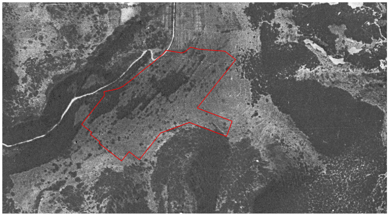
Figure 2.
The first shacks of the settlers (Courtesy of N. Christidis family). [19]
Figure 2.
The first shacks of the settlers (Courtesy of N. Christidis family). [19]
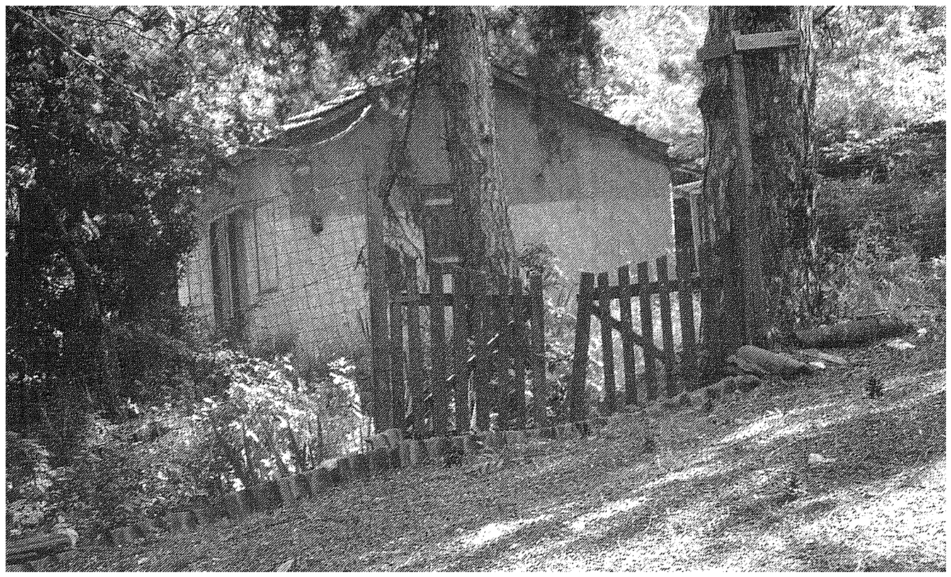
Figure 3.
The first settlers of Chrysopigi, in a religious feast - 15th of August 1958 (Courtesy of N. Christidis family). [19]
Figure 3.
The first settlers of Chrysopigi, in a religious feast - 15th of August 1958 (Courtesy of N. Christidis family). [19]
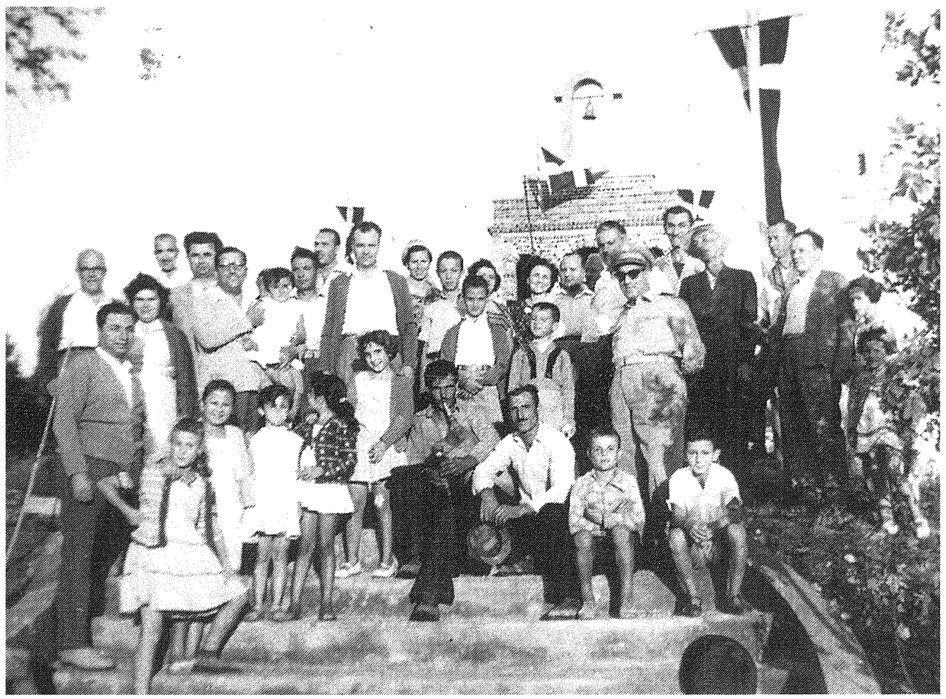
Figure 7.
Flight mission architecture, survey block partitioning, and sensor-kinematic specifications.
Figure 7.
Flight mission architecture, survey block partitioning, and sensor-kinematic specifications.
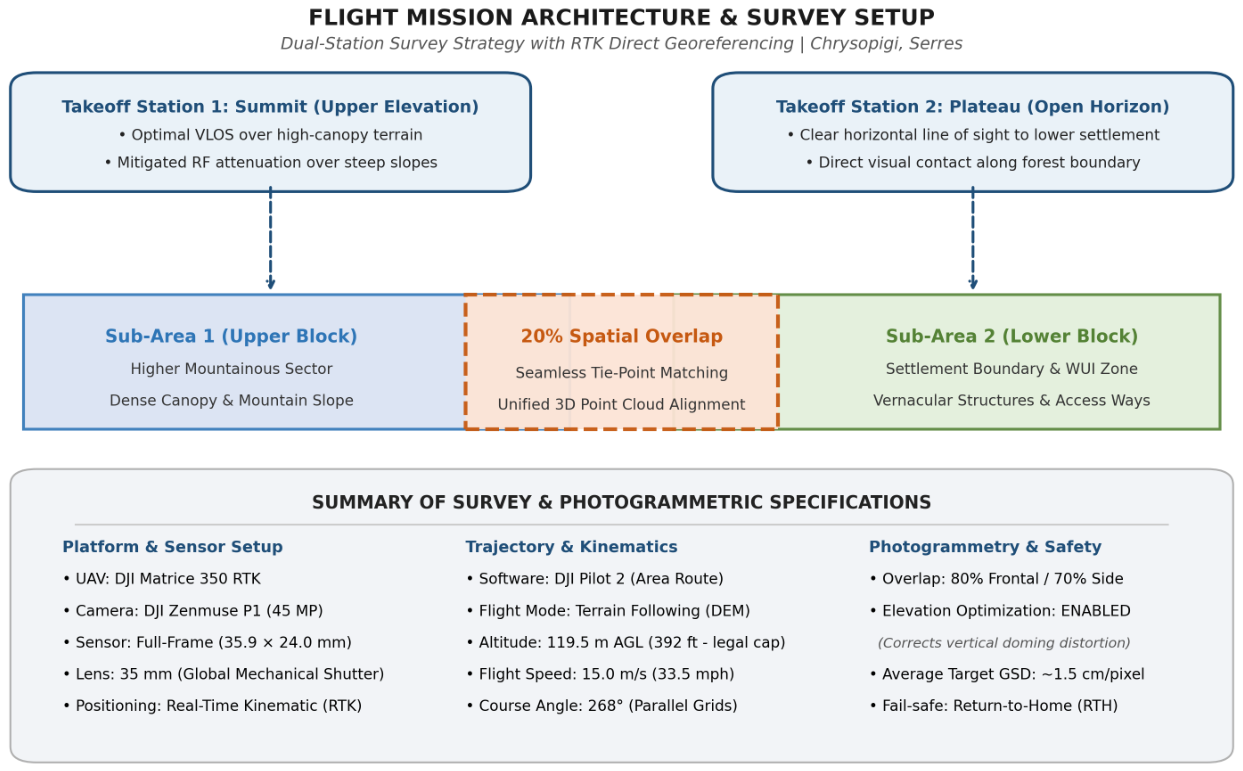
Figure 8.
High-resolution 2D orthomosaic (GeoTIFF) depicting the overall spatial layout of Chrysopigi and the surrounding forest matrix.
Figure 8.
High-resolution 2D orthomosaic (GeoTIFF) depicting the overall spatial layout of Chrysopigi and the surrounding forest matrix.
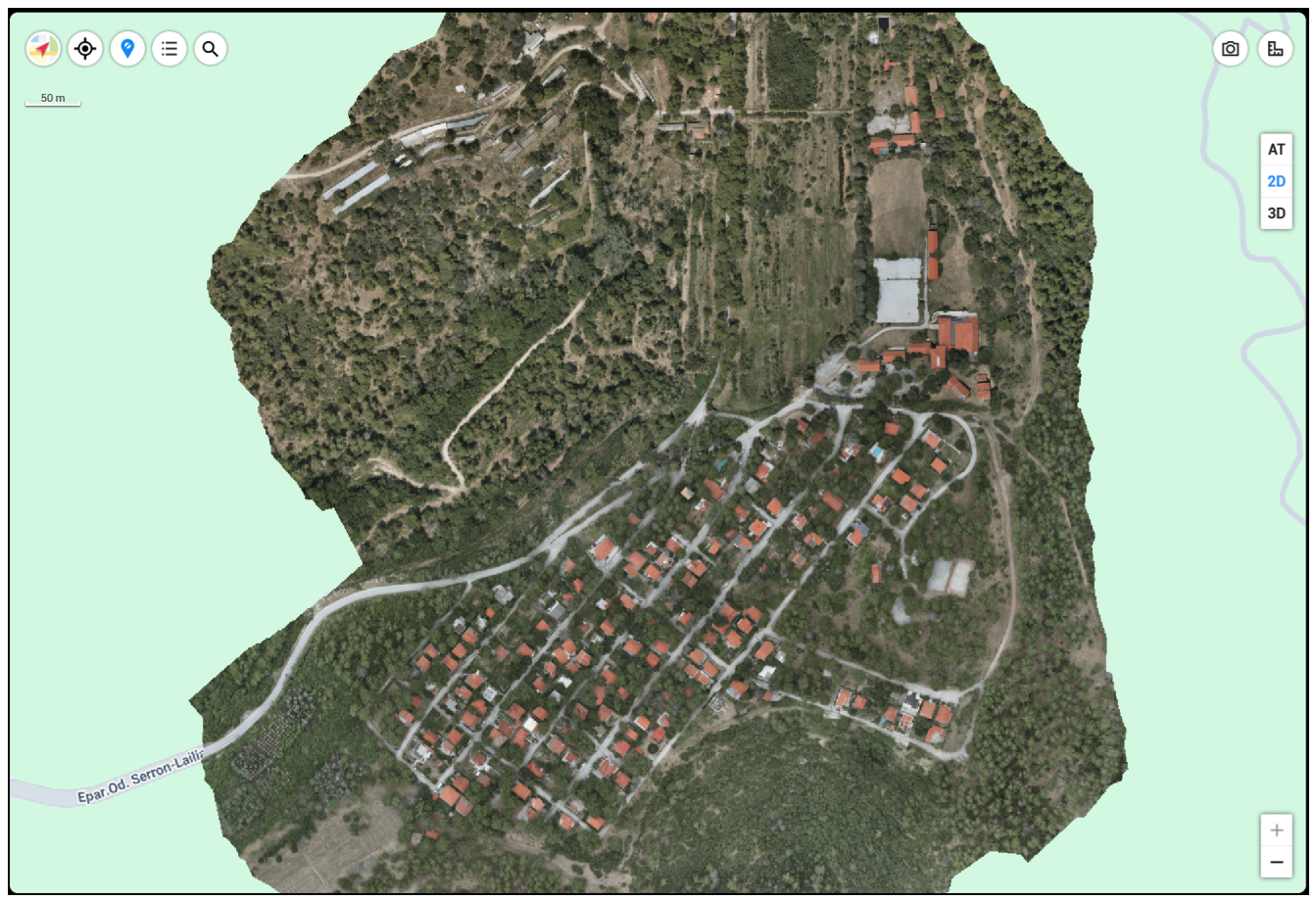
Figure 9.
Perspective view of the 3D Textured Mesh (B3DM/OBJ) illustrating the complex vertical interface between mature pine canopy, terrain topography, and residential structures.
Figure 9.
Perspective view of the 3D Textured Mesh (B3DM/OBJ) illustrating the complex vertical interface between mature pine canopy, terrain topography, and residential structures.
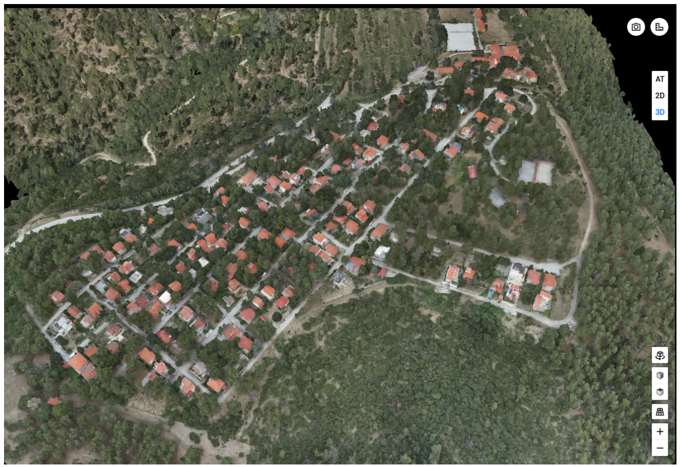
Figure 10.
Detailed view of the 2D orthomosaic showing residential building boundaries and surrounding vegetation.
Figure 10.
Detailed view of the 2D orthomosaic showing residential building boundaries and surrounding vegetation.
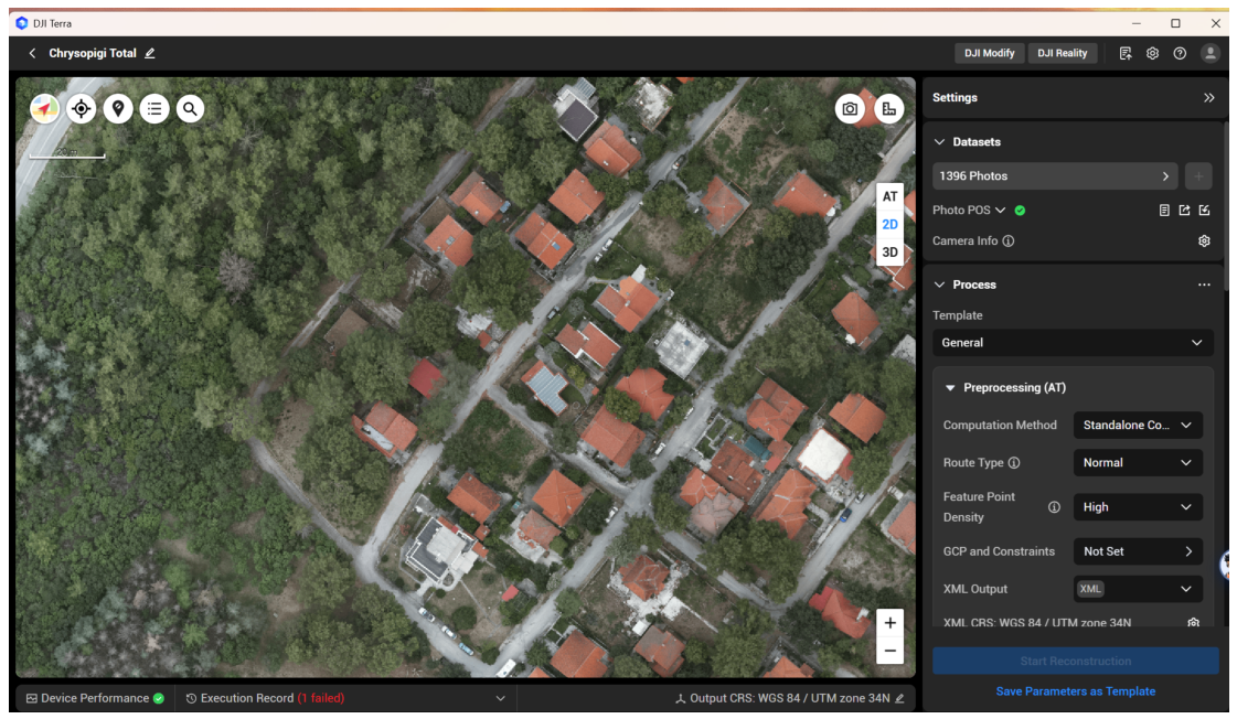
Figure 11.
Close-up perspective render of the 3D Textured Mesh highlighting roof geometries and immediate canopy proximity.
Figure 11.
Close-up perspective render of the 3D Textured Mesh highlighting roof geometries and immediate canopy proximity.
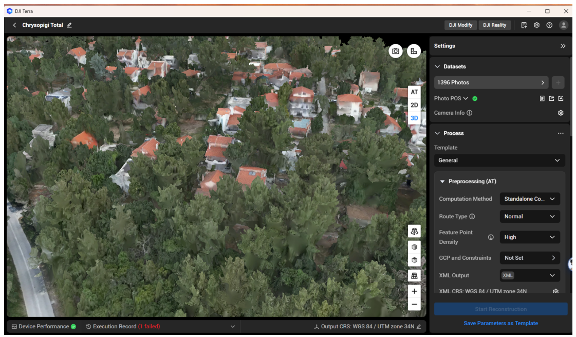

Table 1.
Photogrammetric processing parameters, dataset specifications, and Region of Interest (ROI) elevation metrics generated in DJI Terra (v5.3.5).
Table 1.
Photogrammetric processing parameters, dataset specifications, and Region of Interest (ROI) elevation metrics generated in DJI Terra (v5.3.5).
| Parameter / Metric | Value / Configuration |
|---|---|
| Total Input Aerial Images | 1,396 photos (100% calibrated with POS telemetry) |
| Spatial Reference System | WGS 84 / UTM zone 34N (EPSG:32634) |
| Feature Point Density (AT) | High (Standalone Computation) |
| Average Ground Sampling Distance (GSD) | |
| Region of Interest (ROI) Min. Altitude | 582.298 m a.s.l. |
| Region of Interest (ROI) Max. Altitude | 807.676 m a.s.l. |
| Total Vertical Relief Range | 225.378 m |
| 2D Orthomosaic Resolution | High (100% full resolution GeoTIFF) |
| 2D Reconstruction Features | Intelligent Hole Filling (Fill Hole Intelligently: ON) |
| 3D Mesh Quality & Optimization | High (100% full resolution, simplified/decimated 50%) |
| 3D Output Formats | B3DM, PLY, OBJ, FBX (DJI Modify Compatible) |
Table 2.
Capabilities, analytical utility, and multi-scale spatial outputs derived from the high-resolution 2D and 3D Digital Twin baseline of Chrysopigi.
Table 2.
Capabilities, analytical utility, and multi-scale spatial outputs derived from the high-resolution 2D and 3D Digital Twin baseline of Chrysopigi.
| Digital Baseline Component | Operational & Analytical Utility |
|---|---|
| Ultra-High Resolution Orthomosaic (GeoTIFF) | Precise building footprint digitization, property boundaries, and road network mapping. |
| 3D Textured Mesh (B3DM, PLY, OBJ, FBX) | Multi-perspective structural assessment, roof geometry, masonry walls, and vertical canopy-structure contact. |
| Interactive Cloud Baseline (Web 3D Streaming) | Collaborative web streaming via DJI Modify/Viewer for multi-stakeholder inspection and remote annotation. |
| Spatial Annotation & Metrics (DJI Terra / Viewer Tools) | In-situ distance, area, and volume measurements for fuel management and infrastructure monitoring. |
Table 3.
Wildland–Urban Interface (WUI) spatial risk evaluation dimensions, core spatial findings, and operational management significance across Chrysopigi.
Table 3.
Wildland–Urban Interface (WUI) spatial risk evaluation dimensions, core spatial findings, and operational management significance across Chrysopigi.
| Risk Evaluation Dimension | Spatial Finding & Operational Significance |
|---|---|
| Topographic Slope Vulnerability | Steep slope gradients (10–30%) on western exposures accelerate convective heat transfer toward upper structures. |
| Defensible Space Buffer (0–5 m) | Immediate contact zone exhibiting high vulnerability due to direct tree canopy overhangs and uncleaned litter. |
| Intermediate Protection (5–15 m) | Mixed understory scrub and pine canopy requiring active thinning to prevent vertical fuel laddering. |
| Extended Fuel Reduction (15–30 m) | Continuous pine stands forming horizontal fuel bridges between the main forest matrix and residential lots. |
Table 4.
Spatial evaluation of the access network, evacuation corridors, and critical infrastructure within Chrysopigi.
Table 4.
Spatial evaluation of the access network, evacuation corridors, and critical infrastructure within Chrysopigi.
| Infrastructure Component | Spatial Finding & Operational Significance |
|---|---|
| Main Access Road | Primary asphalt corridor connecting to the Serres–Lailias axis; vulnerable to canopy overhangs and single-point traffic bottlenecks. |
| Vernacular Pedestrian Trails | Dirt path network suitable for secondary pedestrian evacuation and manual fire-break line construction. |
| Emergency Vehicle Maneuverability | Identified narrow street bottlenecks (<3.5 m width) and dead-end turnarounds restricting heavy fire-engine access. |
| Critical Public Infrastructure | Mapping of forest service buildings, research facilities, water supply hydrants, and designated recreation zones. |
Disclaimer/Publisher’s Note: The statements, opinions and data contained in all publications are solely those of the individual author(s) and contributor(s) and not of MDPI and/or the editor(s). MDPI and/or the editor(s) disclaim responsibility for any injury to people or property resulting from any ideas, methods, instructions or products referred to in the content. |
© 2026 by the authors. Licensee MDPI, Basel, Switzerland. This article is an open access article distributed under the terms and conditions of the Creative Commons Attribution (CC BY) license (http://creativecommons.org/licenses/by/4.0/).
Copyright: This open access article is published under a Creative Commons CC BY 4.0 license, which permit the free download, distribution, and reuse, provided that the author and preprint are cited in any reuse.