

Submitted:
11 October 2026
Posted:
13 October 2026
You are already at the latest version
Abstract
Ten US states and dozens of countries have adopted a goal to preserve 30 percent of their land and water resources by 2030. The US 30 × 30 effort seeks to protect wildlife habitats, provide recreation opportunities, mitigate climate change, and avoid the fragmentation of natural areas and working farms and forestlands. Yet, very little research exists on the practice of how to achieve 30x30. In 2023, the State of Vermont passed legislation setting 30x30 and 50x50 as goals. Because Vermont is heavily forested, the preservation of forestland is key to reaching its goals. Fragmentation and parcelization of forests both degrade the forest ecology and reduce the attractiveness for preservation. Land preservation and retention decisions about private property occur locally, but no studies have yet examined the locally available land use tools that influence achieving the 30% goal. This study fills that gap by analyzing the interaction among land preservation, local zoning, state sponsored pref-erential property taxation, and land parcelization activity in 13 forested Vermont towns. Findings show considerable benefit from preferential property taxation, limited benefit from natural resource zoning, and a wide variation in the amount of land preserved. We also found little change in the number of large parcels pre- and post-COVID but some continued land fragmentation among smaller parcels. Sustained funding for land preservation together with the management of forests will be essential steps toward effective preservation in any forested region over the long run.
Keywords:
30X30
; forestland
; parcelization
; fragmentation
; land preservation
; conservation easement
1. Introduction
In January 2021, the Biden Administration issued executive order #14008 establishing a goal for the United States to conserve 30 percent of the nation’s land and water resources by 2030, an objective often referred to as 30x30 [1]. The purpose of 30x30 is broad and includes protecting wildlife habitat, enhancing recreation opportunities, and mitigating climate change by limiting sprawling development and the fragmentation of natural and working landscapes. International efforts have similar objectives. The Kunming-Montreal Global Biodiversity Framework (GBF) of 2022 set a goal to “Conserve 30% of Land, Waters and Seas” [2,3]. A total of 196 countries signed the GBF to protect and manage wildlife habitat and avoid species extinction. Land protection is one of the United Nations Sustainable Development Goals [4]. Goal 15 emphasizes the protection, restoration, and sustainable use of terrestrial ecosystems, especially forests, to stop biodiversity loss by 2030.
Following President Biden’s executive order, a US multi-agency report proposed a “locally led campaign” built on existing preservation tools and emphasizing the preservation of privately owned lands such as working farms and forests [1] (p. 1). The federal government offered limited funding, but the land preservation work for 30x30 would largely be carried out by state and local governments with the support of private, non-profit land trusts (NGOs).
Ten states adopted the federal preservation target and created their own 30x30 strategies, ranging from general policy in Michigan to legislated goals backed by state funding for land preservation in Maryland and Vermont (see Table 1). Although the Trump administration canceled the national 30x30 goal in early 2025, the ten states have continued to pursue 30x30 targets [5]. One of these states is Vermont, a heavily forested state in the northeastern United States, and the focus of this analysis.
Little empirical research exists on specific strategies to achieve 30x30 in the United States or internationally [3,12]. Existing research on meeting 30x30 goals is largely theoretical and emphasizes where conservation should occur and the relationship between protected areas and biodiversity on a national or global scale [18,19]. The US federal government called for local implementation of 30x30, which is largely overlooked by existing research on 30x30. Even so, researchers acknowledge that the preservation of private working lands for 30x30 goals remain fundamental [18,20]. Across the ten participating states, the two largest categories of privately held land are farmland and forestland, which also account for most of the remaining large parcels of unpreserved land [21]. These lands are primarily held locally by families and private companies. Decisions about how to manage these resource lands also occur locally, made by individual landowners, based on profitability, land preservation funding, tax incentives, land markets, land use regulations, and financial goals [22,23]. The most significant threat to these lands, and the rural economies they support, is conversion to commercial and residential development [24]. Because farming and forestry systems operate locally or regionally, these are key scales of analysis for 30x30 progress.
Two local actions are necessary for achieving 30x30: 1) Retaining high conservation value land—prime farmland, biodiverse areas, and intact forests—in large enough parcels to make land preservation economical and effective [25,26], and 2) Permanently preserving those lands. Both retention and preservation can be challenging in states like Vermont that are facing high rural land values and development pressure. Funding for preservation from land trusts and federal, state, and local governments, along with local land use regulations, and state property tax incentives can encourage landowners to decide to preserve their land [22].
For rural towns or counties to contribute to their state’s 30x30 goal, a reasonable aspiration is to preserve 30% or more of their land area. Although land preservation and retention decisions occur locally, no studies have yet examined the locally available land use tools that may aid in achieving the 30% goal. This study fills that gap by analyzing the interaction among land preservation, local zoning, preferential property taxation, and land parcelization activity in 13 forested towns in Vermont. We address three research questions: 1) How much preservation has occurred in these towns to contribute toward the state’s 30x30 goal? 2) To what extent are rural towns retaining large forest parcels for future preservation? and 3) What are the roles of local zoning and use value property taxation for forestland? We answer these questions using changes in municipal tax parcel data between 2019 and 2025, and data on zoning, land preservation, and landowner enrollment in use value taxation. The study concludes with recommendations for states and local governments seeking to achieve 30x30 or generally retain and preserve forestlands.
- Threats to 30x30: Parcelization and Fragmentation
Two types of land use change in forested areas, land parcelization and land fragmentation, pose challenges to the achievement of 30x30 preservation goals. Forest parcelization describes changes in the ownership and parcel sizes of forestland. As large forest properties are subdivided into smaller properties and sold, the number of owners increases and the average forest parcel size declines. Because parcelization is not an immediate land cover change, it is initially difficult to see with the naked eye or through remote sensing. The subdivision of the forest for future residential or commercial development legally occurs, but construction may not follow for several years. Parcelization is indicated by a decrease in the number of large parcels of land – those most attractive for preservation – and an increase in smaller parcels with less natural resource value [27].
Parcelization makes land preservation more difficult because it increases forestland prices per acre (hectare), making holding forestland less attractive than selling it for development. Because land value per acre tends to vary inversely with size, more money and preservation transactions with landowners are needed to preserve the same amount of land. Parcelization is also a precursor to development, which can change the character of an area and drive up the price of surrounding forestland. Parcelization also causes shifts in natural resource management. Large landowners, especially those enrolled in use-value property taxation programs, frequently implement state-approved forest management plans [28]. When forestland is divided into smaller parcels, however, it may be removed from a forest management regime, potentially reducing local timber production, hindering access to forests, and decreasing the attractiveness of adjacent forestlands for preservation [29].
Forest parcelization leads to forest fragmentation, the breaking up of large, contiguous forest blocks into smaller patches. There is a large body of literature on the impacts of forest fragmentation. In the Northeastern US, most of the forest fragmentation has been anthropogenic, resulting from conversion of forests into residences and businesses and the construction of roads and driveways [24]. The forest fragmentation process creates major stressors for forest ecosystems as forestland is lost to development. Smaller patches have less value for timber production, wildlife habitat, carbon sequestration, water filtration, and flood absorption. The fragmentation of habitat into smaller patches of forest is a particular threat to forest-dwelling species [24,29,30]. The larger the core forest, the more likely the forest is to withstand both human and natural shocks. But the larger the forest patch size, the greater the amount of forest edge. Edge effects from adjacent residential and commercial developments and farming and forestry activities can expose forests to pests, invasive species, and diseases extending up to hundreds of meters into the forest core. Riitters et al. [24] reported that most US forests are found in these fragmented landscapes.
- Tools for Retaining Forest to Achieve 30x30
Parcelization and fragmentation of working landscapes like farm and forest lands will increase the difficulty of meeting state 30x30 goals. Research on land use planning and preservation has identified three common public policy tools that may help to retain these rural lands over time: conservation easements, natural resource zoning, and use value property taxation [28,31,32]. These tools are used in many of the states with 30x30 goals, including Vermont.
- Conservation Easements
Privately-owned farm and forestlands can be permanently protected from development and added to a state’s 30x30 count through fee simple purchase by a government agency or a private, non-profit land trust. However, a more popular and affordable land preservation strategy in the United States and a growing number of other countries is the acquisition of conservation easements [33]. A conservation easement is a legally binding agreement in which the landowners accept limits on their right to develop their land for uses other than agriculture, forestry, or open space in exchange for a cash payment and/or tax benefits [12,34]. Most conservation easements are permanent so the restrictions on land use apply to all future landowners. The holder of the conservation easement must monitor the land to ensure that the landowner is abiding by the terms of the easement, which often includes farm or forest management provisions. The value of the conservation easement is the difference between the appraised fair market value of the property and the appraised value restricted to farming, forestry, and open space [34].
By maintaining the land in private hands, land preservation programs can support local timber, agricultural, and tourism industries while keeping the land on the local property tax rolls and meeting conservation goals. Generally, agriculture and forestry operations can continue to operate on preserved land while landowners benefit from preferential property taxation and the management plans or stewardship best practices often required under conservation easements [23,34]. A fundamental goal of land preservation, whether for farming, wildlife habitat, or forestry, is to create large contiguous blocks of preserved land, thus minimizing future land fragmentation [25]. Yet, adequate funding for purchasing conservation easements is a common challenge [27]. As of 2025, more than 61 million acres (24.4 million hectares) of private land in the US have been preserved by government programs and land trust organizations, and conservation easements have accounted for over 60% of that with nearly 38 million acres (15.2 million hectares) preserved ([35] Land Trust Alliance, 2026; [36] National Conservation Easement Database, 2026). Several countries outside the US, notably Australia, Canada, Chile, Costa Rica, Guatemala, and Mexico, also use variations of conservation easements to preserve land [33].
The literature on the preservation of working forests is slim compared to similar research on farmland but advocates the use of conservation easements [31]. A forest easement “protects the important natural values of a forest property—fisheries, water supplies, wildlife habitat, and open space—while ensuring good forest management and sustainable flows of the wood products we need” [31], (p. 1). Forestland preservation has been popular in states with a 30x30 goal, such as Maine and New York. Maine is the leading state in the preservation of private forest land with more than 3.5 million acres (1.4 million hectares) preserved [37]. From the early 1990s to 2012, the State of New York and land trusts preserved over 781,000 acres (316,194 ha) with easements on private forest land involving 128 landowners in the heavily forested Adirondack region of upstate New York [38].
- Land Use Regulation and Property Taxation
Land use planning and regulation in the United States are primarily controlled by local governments. Strong land development controls are less common in rural areas than in urban and suburban communities, but research shows that two common local land use tools, natural resource protection zoning and use-value property taxation, can help local governments retain farmland and forestlands [39,40].
Zoning is not a permanent solution but may provide short- to medium-term protection for forestland to prevent extensive parcelization and fragmentation. Research shows that rural residential zoning results in forest lots of less than 25 acres (10 hectares), parcel sizes that make forestry uneconomical and create edge effects that degrade wildlife habitat and overall climate resilience [23,24,29]. Natural resource zoning that results in lots of more than 25 acres (10 hectares), and especially greater than 40 acres (16 hectares) would be considered protective [22].
Use-value property taxation is a common tool in states with a large amount of farm and forestland, like Pennsylvania and Vermont [22,28]. It can help to retain large parcels of land over time by reducing the tax burden on these types of properties [28]. Unlike zoning, which is controlled by local governments, use-value taxation is enacted at the state level, making it available to all qualifying rural landowners. Notably, the research connecting use-value taxation to the retention or preservation of working lands points to short run as opposed to long run success because the amount of money that developers and other buyers can pay to purchase farm or forest lands easily exceeds the property tax incentive over the long run [40].
2. Materials and Methods
Vermont provides a valuable case study of efforts to achieve 30x30 because of the large amount of privately owned forestland and the ongoing demand for rural homesites and vacation home properties. Vermont’s combination of variability in local zoning, enrollment in use-value taxation, and area of land preserved, provides insights into the opportunities and obstacles toward reaching 30x30 and managing future forest parcelization and fragmentation. We use this policy environment to examine the interactions between these programs and their outcomes in 13 rural, heavily forested Vermont towns.
Both the existing literature and tools available in states that have adopted 30x30 goals suggest three key measures of success toward 30x30: 1) The absolute amount and the percentage of a town or county that is preserved. The more preserved land in the jurisdiction, the more it is contributing to the state’s 30x30 goal; 2) Participation in the state’s Current Use (use value taxation) program and the extent and characteristics of supportive local zoning; and 3) The degree of land parcelization as an indicator of the obstacles and remaining opportunities for future land preservation. Land preservation decisions by landowners and preservation organizations are influenced by existing preservation, local zoning, enrollment in use value taxation, and the degree of local land parcelization. Similarly, existing land preservation, local zoning, and enrollment in use value taxation can influence local land parcelization activity. Thus, the interactions among land preservation, land parcelization, local zoning, and use value taxation underlie current and future 30x30 success.
- The Case of Vermont
The State of Vermont covers 5.9 million acres (2.3 million hectares) in the northeast corner of the United States (see Figure 1). Rural lands are divided among 242 towns averaging roughly 25,000 acres (10,000 hectares). Each town has control over land use planning and zoning within its borders. Vermont has only 645,000 people, two-thirds of whom live in settlements of less than 2,500 residents [41]. Only Wyoming among the states has fewer inhabitants.
In the 1960s, the construction of interstate highways I-89 and I-91 made Vermont accessible within a 3- to 6-hour drive of the Boston and New York City metropolitan areas [27]. The rising popularity of skiing in Vermont especially drew visitors from out-of-state. This sparked a demand for second homes, which now account for 17 percent of Vermont’s housing stock, the second highest percentage in the nation after Maine [42]. Because the majority of second homes have been built in rural areas, they have contributed to forest parcelization and fragmentation [43].
An important study of land parcelization showed that from 2005 to 2020 the area of privately held woodland decreased by 189,000 acres (76,000 hectares) or more than 19 percent [44]. Woodland in parcels of greater than 50 acres (20 hectares) fell by more than 4 percent, accounting for about half of the decline in woodland acres. Meanwhile, residential land increased by 202,000 acres (81,000 hectares) or almost 9 percent, and the number of parcels of 5 to 10 acres (2 to 4 hectares) grew by 16 percent, indicating greater parcelization of the land base [44].
In 2023, the Vermont legislature passed Act 59, The Community Resilience and Biodiversity Protection Act, which set a goal to preserve 30% of the state by 2030, with a more distant goal to preserve half of the state by 2050 [45]. Forests cover 4.59 million acres (1.8 million hectares) or 78 percent of Vermont, and the forest industry contributes over $3.3 billion to the state economy in forest products, tourism, and recreation [46]. Of the 80 percent of forests in private ownership, nearly all are held by families and individuals; corporate ownership is about one percent [47].
Vermont is a useful case study because all three tools discussed in the land use policy and literature are available to towns or landowners and can contribute to Vermont’s 30x30 goal: land preservation, use-value taxation, and natural resource zoning. The three tools work at slightly different scales. Use-value taxation is a state program, zoning is municipal, and land preservation involves state and federal funding along with land trust projects; yet all have a similar goal of retaining working farming and forest landscapes over time.
Vermont has made considerable progress toward preserving 30% of the state. There are an estimated 930,000 acres (372,000 ha) of preserved forestland out of a total of 1.63 million preserved acres (652,000 ha) [16] (see Table 2). Land preservation includes both public and private actors. Since 1977, the private nonprofit Vermont Land Trust has preserved more than 450,000 acres (180,000 hectares) of forestland, primarily through conservation easements [48]). In 1987, the Vermont legislature created a new state agency, the Vermont Housing and Conservation Board (VHCB), to finance affordable housing and land preservation projects [16]. The VHCB often partners with the Vermont Land Trust on land preservation projects.
Congress created the federal Forest Legacy Program in 1990 to make grants to states for the preservation of privately-owned forest land, mainly through the purchase of conservation easements. The Forest Legacy Program provides up to 75% of the forest preservation cost, and requires at least a 25% match from state, local, and non-profit sources. To date, the Forest Legacy Program has helped to preserve more than 3 million acres across the US and US territories [49]. Vermont has received $27.3 million in Forest Legacy funds which have resulted in the preservation of over 80,000 acres (32,000 hectares) in 71 projects [50].
Vermont’s state government has offered preferential assessment of farmland and forestland—the Current Use Program—since 1980. The program is voluntary for landowners and results in a lower property tax in return for the landowner’s agreement not to develop the land enrolled in the program. The Current Use Program requires a landowner to enroll a minimum of 25 acres (10 hectares). Qualifying forestland must also have or create an approved forest management plan. Current Use provides short- to medium-term protection from development because landowners who withdraw from the program must pay a Land Use Change Tax of 10% of the full fair market value of the land that is withdrawn or developed [51]. There are more than 19,000 properties enrolled in the Current Use Program, totaling more than 2.5 million acres (1 million hectares), or more than 40 percent of Vermont’s total land area [51].
Local zoning varies considerably across rural Vermont, and many of the smaller towns have not adopted a zoning ordinance or have adopted a zoning ordinance that does not include natural resource protection zoning. Rather, minimum lot sizes for forest land typically vary from less than 2 acres (.8 hectares) to up to 5 acres (2 hectares). This zoning is more often associated with rural residential development than with discouraging the subdivision of forestland [27,44]. The 2023 report by the Vermont Natural Resources Council found that forestland was especially vulnerable to subdivision in rural residential zoning districts [44].
- Selecting Case Study Towns
We selected case study towns based on four criteria. First, the towns must have at least 30 percent forest cover, to align with Vermont’s 30x30 goal. Second, the towns must be in a region which has experienced significant forestland conversion. A 2023 study noted that the conversion of forestland to developed uses was especially evident in the northeast and north central counties of Caledonia, Essex, Lamoille, and Orleans [44]. We chose case study towns in these counties and from neighboring Washington County (see Figure 2a). Third, the towns must be rural in character and economy, and fourth, the population must be rural, ranging between 500 and 1,400 (see Table 3). More populous towns exhibit a more urban character and have less forest cover, making them less comparable and less attractive for preservation.
In all, 13 towns met the criteria. Land preservation and the Current Use program are available in all 13 towns, although activity varies. Five of the towns have adopted a zoning ordinance, but each ordinance has different characteristics (Table 3). This variation allows us to examine the characteristics and impacts of zoning together with use-value taxation and land preservation for progress toward 30x30.
- Evaluating Three Land Use Tools
We evaluated land preservation, use value property taxation, and local zoning using state and regional databases. The greater the amount of preserved land and the higher the percentage of land in the town that is preserved, the more that town contributes to the state’s 30% goal (see Figure 2b). Similarly, the larger the amount of land and the higher the percentage of the town enrolled in the Current Use Program, the greater the expected potential for future land preservation. The Vermont Agency of Natural Resources maintains a database of preserved land parcels and parcels enrolled in the Current Use Program. We queried these databases in December 2025. We further examined which of the 13 towns have zoning and which towns with zoning include a natural resource district. The regional planning commissions in which the five towns with zoning are located provide geographically referenced zoning maps, which we confirmed by comparison to each town’s current zoning ordinance. Only four of the five towns with zoning had a zoning map available. The fifth, Montgomery, had no available zoning map.
- Measuring the Parcelization of Vermont Towns
Land parcelization is an indicator of both future development activity and future preservation challenges. If large blocks of forestland are subdivided into smaller blocks for sale for residential or commercial development, forestland is not being retained, and the preservation potential of the area is diminished.
To understand parcelization in the 13 case study towns, we examined changes in parcel size between 2019 and in 2025. Generally, the total amount of land in a town holds steady from year to year, so increases in the number of parcels over time, changes in size categories, and decreases in the average parcel size, indicate the degree of parcelization. The same amount of land exists, but it is divided into smaller properties. The study years were chosen in part due to data availability, but also because the Covid-19 pandemic may have accelerated the parcelization of forests in Vermont. The state was perceived as a haven from the pandemic and to a lesser degree as a haven from climate change [53].
We began by categorizing all parcels in each town by size (see Table 6a and Table 6b). Size categories were drawn from recent studies [54], but with added emphasis on large properties of 40+ acres (16+ hectares), which support timber revenue and are the most attractive for preservation. We identified the number of lots of 5 to 9.99 acres (2 to 4 hectares), as these are common sizes for residential development in rural communities, and parcels of less than 10 acres (4 hectares), which also have less value for timber production than larger parcels (ibid). We also tracked parcels in mid-range and larger sizes of 10 to 19.99 acres (4 to 8 hectares), 20 to 39.99 acres (8 to 16 hectares), and 40+ acres (16+ hectares) and calculated the total amount of land in each size category. Shifts in the number of parcels in different size categories over the 6-year study period allowed us to assess whether towns had retained or lost the large forest parcels that facilitate land preservation.
We used geographically referenced tax parcel data provided by the Vermont Parcel Program [52]. The data are reported by each town individually, so there were some small annual discrepancies and format differences. Some towns show a slight change in overall land area from year to year, for example. There is also a slight difference in the format of the 2019 and 2025 data, as shown in Table 5. We cleaned the data to the extent possible.
3. Results
3.1. Land Preservation
In four of the 13 study towns, more than 30% of the land base has already been preserved (Table 3). Two towns – Eden and Worcester – are close to 50% preserved. Notably, most of this preserved land is not public forests or parks, but rather consists of privately owned farmland and forestland, called Category 3 in Vermont. In the case study towns, which are highly forested with minimal agriculture (Figure 2a), this is mainly working forest. The remaining nine towns are further from the 30% goal, including six that do not yet have 15% of their land preserved. The average across the 13 towns is 21% preserved.
3.2. Land Preservation and Land Use Tools
Vermont’s Current Use program provides a property tax reduction for working farm and forestry landowners who choose to enroll their property. All 13 case study towns have over 30% of their land area enrolled in Current Use and eight towns are over 50% (Table 4). The average parcel size enrolled in Current Use is also over 100 acres for every town, indicating that large forestry parcels, those with significant preservation merit, remain. This also suggests the potential for creating large contiguous blocks of preserved land, a key strategy. However, while the Current Use program appears popular for forestry landowners, especially for those with large parcels, it has not yet translated into widespread preservation. In two towns, landowners have preserved more than 50% of their land that is enrolled in Current Use while in the other 11 towns, landowners have preserved less than 30% (Table 4). In three towns, landowners have preserved less than 10% of Current Use lands.
Five of the case study towns have adopted a zoning ordinance, while eight have not (Table 3 and Table 4). Towns without zoning are comparable in size and population to the towns with zoning. The mean population of towns with zoning in our sample is 1,078 and the average of towns without zoning is 928. Notably, however, the three smallest towns, Newark, Roxbury, and Waterville do not have zoning.
All five of the towns with zoning have a natural resource-oriented zoning district in their zoning ordinance. The percentage of the town included in that zone varies widely from 4.7% in Brighton to 88.3% in Woodbury, likely because the towns differ in how they use the zone. Two are highly inclusive. Sutton’s “working lands” district includes the majority of the town, 79%, and Woodbury’s zone is not purely resource land, but includes low density residential, as well and covers 88.3% of the town. Brighton’s “conservation lands” zone, however, is far narrower, applying to only 4.7% of the town. Braintree falls in the middle of the two extremes with a “conservation” zone that is separate from the “rural” zones and includes 26.4% of the town. The final town, Montgomery, has a zoning ordinance but no zoning map was available.
Results show minimal difference in land preservation between towns with zoning and towns without zoning (Table 3). Of the four towns with more than 10,000 acres (4,000 hectares) of preserved land, two have zoning (Brighton and Montgomery) and two do not (Eden and Worcester). The average percentage of land preserved for towns with zoning (22.4%) is only slightly higher than for towns without zoning (21.4%).
Four of the five towns with a zoning ordinance had more than 50% of their land enrolled in the Current Use program while four of the eight towns without zoning reached the 50% threshold (Table 4). Towns with zoning also tended to have somewhat larger average parcel sizes enrolled in Current Use, an overall average of 191 acres, compared to 175 acres for towns with no zoning.
While limited in scope, a review of zoning maps for the four towns for which they are available shows no clear relationship between land enrolled in Current Use and the underlying zoning district. Both Brighton and Braintree, for example, have natural resource zoning districts, but most of the Current Use lands are located in their less restrictive “rural” zoning districts.
3.3. Parcelization
Over the six-year study period, the 13 case study towns experienced a small amount of parcelization of the largest forest parcels (100+ acres, 40+ hectares) (Table 5). Of 671 large forest parcels, 25 (3.71%) were subdivided into smaller parcels. Given that all 25 were over 100 acres, this represents a minimum of 2,500 acres of potential new forest disturbance. Three towns saw an increase in the number of 100+ acre parcels, likely because some large parcels were broken into smaller parcels that still exceeded 100 acres. The average parcel size of 100+ acre parcels decreased in six of the 13 towns and increased in seven towns.

Table 5.
Changes in 100+ Acre Parcels by Town and Zoning Status. Towns that have adopted a zoning ordinance are in bold.
Table 5.
Changes in 100+ Acre Parcels by Town and Zoning Status. Towns that have adopted a zoning ordinance are in bold.
| Town | Year of Land Parcel Measurement |
Total Acres (ha) |
Total Acres in 100+ Acre (40+ ha) Parcels and % of Total Town Land Area |
Number of 100+ Acre (40+ ha) Parcels |
Average Parcel Size in Acres (ha) of 100+ Acre (40 ha+) Parcels | Median Parcel Size in Acres (ha) of 100+ Acre (40+ ha) Parcels |
|
Braintree |
2019 | 27,570 | 15,890 57.6% |
64 | 248 | 163 |
| 2025 | 24,763 | 15,330 61.9% |
64 | 240 | 163 | |
|
Brighton |
2019 | 34,621 | 24,971 72.1% |
57 | 438 | 204 |
| 2025 | 34,624 | 24,731 71.4% |
55 | 450 | 208 |
|
| Brownington |
2019 | 27,902 | 6,961 24.9% |
38 | 183 | 134 |
| 2025 | 26,881 | 6,636 24.6% |
37 | 179 | 134 | |
| Charleston |
2019 | 24,804 | 14,985 60.4% |
66 | 227 | 164 |
| 2025 | 24,805 | 14,291 57.6% |
66 | 216 | 161 | |
| Eden |
2019 | 40,544 | 31,929 78.8% |
64 | 499 | 252 |
| 2025 | 40,534 | 31,182 76.9% |
53 | 588 | 227 | |
| Glover |
2019 | 25,804 | 15,871 61.5% |
68 | 233 | N/A |
| 2025 | 25,574 | 13,696 53.6% |
59 | 232 | 214 | |
|
Montgomery |
2019 | 37,455 | 19,122 51.1% |
70 | 273 | N/A |
| 2025 | 37,173 | 18,157 48.8% |
74 | 245 | 237 | |
| Newark |
2019 | 23,844 | 12,522 52.5% |
52 | 241 | 143 |
| 2025 | 23,843 | 12,800 53.6% |
50 | 256 | 161 | |
| Roxbury |
2019 | 26,771 | 15,902 59.4% |
42 | 377 | 155 |
| 2025 | 26,772 | 15,706 58.6% |
39 | 403 | 176 | |
|
Sutton |
2019 | 24,757 | 14,694 59.4% |
47 | 313 | 185 |
| 2025 | 24,756 | 14,710 59.4% |
48 | 306 | 184 | |
| Waterville |
2019 | 10,738 | 5,141 47.9% |
29 | 177 | 153 |
| 2025 | 10,798 | 5,556 51.4% |
31 | 182 | 140 | |
|
Woodbury |
2019 | 25,124 | 14,480 57.6% |
46 | 315 | 184 |
| 2025 | 25,123 | 14,003 55.7% |
42 | 333 | 176 | |
| Worcester |
2019 | 24,927 | 17,160 68.8% |
28 | 613 | 197 |
| 2025 | 24,919 | 17,367 69.7% |
28 | 620 | 215 |
Seven towns had an average large parcel size of less than 300 acres (120 hectares). Three of those towns (Brownington, Glover and Newark), all without zoning, showed a decrease in 100+ acre parcels. In the four towns with more than 30% preserved land, only Eden showed a marked decrease in the number of 100+ acre (40+ hectare) parcels between 2019 and 2025. In the three towns that were close to or just above the 20 percent preserved level, only one, Roxbury, had a decline in the number of 100+ acre parcels. Overall, the land base of these large parcels appears relatively stable between 2019 and 2025, particularly among towns with significant land preservation.
3.4. Parcelization and Land Use Tools
Table 5 shows that the number of 100+ acre parcels increased in three towns, decreased in seven towns, and did not change in three towns. All 13 towns had at least 30% of their land enrolled in Current Use. So, enrollment in Current Use alone was not a strong predictor of retaining large parcels of land.
We expected to see more parcelization in towns without zoning than in towns with zoning. Table 5 indicates an overall decline of 24 parcels of more than 100 acres (40 hectares) in towns without zoning, and a net decrease of one large parcel in the towns with zoning. Most of the decline came from two towns without zoning, Eden and Glover.
Table 6a and Table 6b show that for the two main small parcel categories: 5 to 9.99 acres (2 to 4 hectares), towns without zoning had a total of 7 more parcels in the 5-9.99 acres category and 28 more parcels in the 10 to 19.99 acres category from 2019-2025 (see Table 6a). Meanwhile, towns with zoning had an increase of 21 parcels in the 5 to 9.99 acres category and 36 more parcels in the 10 to 19.99 acres category. Thus, contrary to expectation, parcelization in the 5-to-19.99-acre range appeared higher in the towns with zoning from 2019 to 2025. There was little difference between towns with and without zoning in the parcel categories of 20 to 39.99 and 40 to 99.99 acres.
Table 6a.
Land Fragmentation and Parcelization in Towns without Zoning.
| Town | Year | Number of 5-9.99-acre parcels | Number of 10-19.99-acre parcels | Number of 20-39.99-acre parcels | Number of 40-99.99-acre parcels |
|---|---|---|---|---|---|
| Brownington | 2019 | 61 | 152 | 61 | 74 |
| 2025 | 55 | 163 | 69 | 73 | |
| Charleston | 2019 | 67 | 177 | 87 | 65 |
| 2025 | 72 | 188 | 91 | 74 | |
| Eden | 2019 | 55 | 168 | 63 | 55 |
| 2025 | 75 | 170 | 63 | 49 | |
| Glover | 2019 | N/A | 120 | 79 | 80 |
| 2025 | 59 | 121 | 77 | 80 | |
| Newark | 2019 | 77 | 168 | 95 | 78 |
| 2025 | 81 | 164 | 93 | 69 | |
| Roxbury | 2019 | 53 | 127 | 91 | 89 |
| 2025 | 50 | 124 | 86 | 96 | |
| Waterville | 2019 | 35 | 51 | 38 | 28 |
| 2025 | 22 | 66 | 41 | 24 | |
| Worcester | 2019 | 75 | 84 | 57 | 64 |
| 2025 | 76 | 79 | 52 | 60 |
Table 6b.
Land Fragmentation and Parcelization in Towns with Zoning.
| Town | Year | Number of 5-9.99-acre parcels | Number of 10-19.99-acre parcels | Number of 20-39.99-acre parcels | Number of 40-99.99-acre parcels |
| Braintree | 2019 | 55 | 111 | 53 | 78 |
| 2025 | 67 | 121 | 57 | 73 | |
| Brighton | 2019 | 60 | 117 | 87 | 55 |
| 2025 | 65 | 117 | 80 | 54 | |
| Montgomery | 2019 | N/A | 246 | 129 | 68 |
| 2025 | 98 | 258 | 126 | 71 | |
| Sutton | 2019 | 93 | 143 | 75 | 66 |
| 2025 | 93 | 149 | 80 | 66 | |
| Woodbury | 2019 | 75 | 118 | 75 | 71 |
| 2025 | 79 | 126 | 77 | 73 |
4. Discussion
Goals to preserve 30x30 goals are typically set at the state or national scale, but most implementation occurs locally. If counties and towns, like the 13 examined here, can achieve 30% preservation and retain large parcels of forestland over time, their states will be more likely to meet their 30% preservation goals. Preservation and parcelization results from 13 towns in Vermont show that many large forest parcels remain, even in the face of significant development pressure, indicating significant potential for more land preservation. But the amount of land preserved in each town has varied. Only four of the 13 towns have achieved 30% preservation, with an overall average of 21% of the land area preserved. All towns have preserved some land, most of it forestland, which has contributed to the 30x30 goal and should help support the rural economy.
Based on recent land preservation trends, however, Vermont seems unlikely to achieve its 30% land preservation goal by 2030. Currently, 27% of the state’s land area is preserved. Another 3% to preserve equates to about 170,000 acres (68,000 hectares). About 10,000 acres (4,000 hectares) a year have been preserved in recent years [16,55].
Land parcelization can present a challenge for future land preservation. Land that is subdivided into smaller properties is more expensive to preserve and makes forestland vulnerable to future development and fragmentation. In the 2019 to 2025 study period, which includes the Covid-19 pandemic, parcelization activity in the 13 towns occurred mainly among smaller parcels of 5 to 19.9 acres but not much among the largest properties (100+ acres. These findings are generally consistent with a previous study that raised alarms about the parcelization of forestland [44], but do not reflect the fragmentation of large parcels that study reported. The previous study used older data and a longer time frame, which showed more change [44]. Future studies should continue to track parcelization trends to understand if parcelization is slowing down or increasing.
Use value taxation and local zoning could support local land preservation and forest retention efforts, but their role is understudied. Results from the 13 towns suggest two broad insights: the significance of use-value taxation programs and the challenge of zoning in rural areas. Use value taxation is often overlooked in planning literature but is a popular tool in rural communities (Daniels and Bowers, 1997). Enrollment in Vermont’s use-value taxation program, Current Use, comprised over 30% of the land area in all 13 towns, and over 50% in eight of the towns. The average parcel size enrolled in Current Use across all the towns was 180 acres (72 hectares), highlighting, again, that large parcels remain and a large contiguous blocks forest preservation strategy remains a possibility. About one-fifth or more of the land enrolled in Current Use is also preserved in nine of the 13 towns.
Results also show only minor connections between zoning and land preservation and that, where it exists, town zoning is highly variable and likely not sufficiently restrictive to make a difference. The five towns with zoning had only slightly more land preserved and more land enrolled in the Current Use program than the eight towns without zoning. Moreover, there was little difference in parcelization activity between towns with or without zoning.
Current Use lands were found in almost all zoning districts, including residential. This finding is concerning given that a 2023 study concluded that most of the forest fragmentation had occurred in rural residential zones [44]. Overall, these findings suggest that zoning is not sufficiently restrictive in most towns to make a difference in parcelization activity. This result aligns with previous findings that zoning of one dwelling unit per 25 acres or more is needed to reduce rural residential development [23,29]. More research is needed on the relationship between forest preservation, forest zoning, and forest fragmentation.
Goals like biodiversity and climate change mitigation and adaptation require natural resource management. Implicit in the preservation of working landscapes as a 30x30 strategy is that these lands are managed to maximize ecosystem services, not solely for food and fiber production. As states preserve more active forestry land, the management burden grows. States may find that they need to increase management assistance to landowners to achieve a broad array of 30x30 goals, especially as climate change raises temperatures and drought conditions that exacerbate wildfire possibilities.
5. Conclusions
This study of 13 forested towns in rural Vermont analyzes the local path to 30x30. Existing research has only acknowledged the importance of preserving private lands and has not examined the local land parcelization trends, zoning, and property taxation strategies that can influence land preservation. Our results fill that gap and underscore that local land preservation in rural Vermont is occurring unevenly, but steadily, and use-value taxation and conservation easements are particularly important tools. Zoning in the case study towns, however, was weak to non-existent, and had less impact. This is the first study to directly examine the local factors involved in meeting the 30x30 goal and the interaction among private land preservation, zoning, and property taxation and land parcelization. With the 2030 deadline approaching, similar research is needed across the ten states with the 30x30 goal.
Existing research on 30x30 tends to focus on public lands and biodiversity, overlooking the role of private working lands and their rural economic benefits. Our results show that numerous large parcels remain in the 13 study towns, despite on-going development pressures. These large parcels are mostly working forests, as suggested by the high amount of mapped forest lands in those towns. The retention of large parcels maintains the potential for the preservation of contiguous blocks through the purchase of conservation easements. Large blocks support forestry operations but are also cost-effective for land preservation and beneficial for biodiversity, if managed appropriately. Notably, the two tools most used in the 13 towns examined here, use-value taxation and conservation easements, keep land in the hands of private forest owners and have a required land stewardship component. Our findings suggest that preferential property taxation and conservation easements are the key pathways for meeting 30x30 goals in states like Vermont with extensive forested areas.
The land parcelization results described here also contribute to the literature on forest fragmentation and preservation. Existing forest fragmentation studies focus on identification and environmental impacts, not how parcelization is progressing and its relationship to zoning, use value assessment, or land preservation. Future research should continue to examine towns and counties with different land use controls and how they relate to preservation success and parcelization activity, especially of forestland, which is understudied compared to farmland.
The analysis of land preservation, use value taxation, zoning, and parcelization presented in this paper can be replicated in the other nine 30x30 states to track progress and refine preservation strategies. For example, only Maryland among the ten states with a 30x30 goal has met and exceeded 30% (see Table 1). International, comparative studies of 30x30 progress could also suggest useful programs and policies. But the tools and methods presented in this paper could also be applied in any state or country where forest preservation and retention are priorities.
References
- US Department of the Interior; US Department of Agriculture; US Department of Commerce; and Council on Environmental Quality. Conserving and Restoring America the Beautiful. 2021. Available online: https://www.doi.gov/sites/default/files/report-conserving-and-restoring-america-the-beautiful-2021.pdf (accessed on 27 September 2025).
- United Nations Environment Programme. Kunming-Montreal Global Biodiversity Framework. 2026. Available online: https://www.unep.org/resources/kunming-montreal-global-biodiversity-framework (accessed on 15 June 2026).
- Campaign for Nature. 30X30 Global Assessment 2026. 2026. Available online: https://www.30x30assessment.com/30x30-full-assessment.pdf (accessed on 1 October 2026).
- United Nations. Transforming our world: The 2030 agenda for sustainable development. 2023. Available online: https://sdgs.un.org/2030agenda (accessed on 9 April 2026).
- Villagomez, A.; Hidayat, A. The U.S. terminated its 30×30 conservation plan but this also presents an opportunity. 2025. Available online: https://news.mongabay.com/2025/02/the-u-s-terminated-its-30x30-conservation-plan-but-this-also-presents-an-opportunity-commentary/amp/ (accessed on 21 January 2026).
- California Dept. of Natural Resources. Pathways to 30X30 California Annual Progress Report Sacramento, CA, USA, p. 3. 2025. Available online: https://resources.ca.gov/-/media/CNRA-Website/Files/2025-30x30-Pathways-Progress-Report.pdf (accessed on Sept. 27 2025).
- Hawaii Dept. of Land and Natural Resources. 30X30 Watershed Initiative. Honolulu, HI, USA, 2025. Available online: https://dlnr.hawaii.gov/dofaw/30x30/ (accessed on Sept. 27 2025).
- Maine Climate Council. 30% Land Goal. Augusta, ME, USA, 2023. Available online: https://www.maine.gov/future/sites/maine.gov.future/files/2023-12/2023.11.29%20NWL%20Additional%20Slides.pdf.
- Maryland Dept. of Natural Resources. Governor Moore Announces Maryland Meets 30% of State Land Conservation Goal Six Years Ahead of Schedule, May 6, 2024. Annapolis, MD, USA. Available online: https://news.maryland.gov/dnr/2024/05/15/governor-moore-announces-maryland-meets-30-of-state-land-conservation-goal-six-years-ahead-of-schedule/#:~:text=The%20Department%20of%20Agriculture%20primarily,the%20land%20for%20residential%20uses (accessed on Sept. 26 2025).
- Massachusetts Department of Fish and Game. Biodiversity Conservation Goals for the Commonwealth. Boston, MA, USA, 2025. Available online: https://www.mass.gov/doc/massachusetts-biodiversity-goals-report-2025/download (accessed on Sept. 27 2025).
- Michigan Department of Environment; Great Lakes; and Energy. MI Healthy Climate Plan. East Lansing, MI, USA, 2022. Available online: https://www.michigan.gov/egle/-/media/Project/Websites/egle/Documents/Offices/OCE/MI-Healthy-Climate-Plan.pdf (accessed on Sept. 28 2025).
- National Caucus of Environmental Legislators. 30x30 Midpoint: Are States on Track to Conserve 30% of Land and Waters by 2030? 2025. Washington, DC, USA. Available online: https://ncel.net/articles/30x30-midpoint-are-states-on-track-to-conserve-30-of-land-and-waters-by-2030/ (accessed on 20 January 2026).
- New Mexico Energy; Minerals; and Natural Resources Dept. Framework for a Uniquely New Mexico 30 × 30. Santa Fe, NM, USA, 2025. Available online: https://www.emnrd.nm.gov/sfd/framework-for-a-uniquely-new-mexico-30-x-30/ (accessed on Sept. 27 2025).
- New York Dept. of Environmental Conservation. New York State 30 × 30: Conserving 30 Percent of Lands and Waters by 2030: Draft Strategies and Methodology. Albany, NY, USA, 2024; p. 1. Available online: https://dec.ny.gov/sites/default/files/2024-07/nys30 (accessed on Sept. 27 2025).
- University of Michigan; School for the Environment and Sustainability. Michigan the Beautiful Great Lakes Final Report Ann Arbor, MI, USA, p. 28. 2025. Available online: https://graham.umich.edu/media/files/Michigan-the-Beautiful-Great-Lakes-Final-Report.pdf (accessed on Sept. 27 2025).
- Vermont Housing and Conservation Board. Annual Report 2024. Montpelier, VT, USA, 2025. Available online: https://vhcb.org/wp-content/uploads/2025/06/2024-VHCB-Annual-Report-web_rev.pdf (accessed on Sept. 26 2025).
- Western Resource Advocates. How Are States Helping to Achieve 30 × 30? Boulder, CO, USA, 2022. Available online: https://westernresourceadvocates.org/how-are-states-helping-to-achieve-30.
- Dreiss; L. Malcom, J. Identifying key federal, state, and private lands strategiesfor achieving 30 × 30 in the United States. Conserv. Lett. 2021, 1, 1–12. [Google Scholar] [CrossRef]
- Robinson, J.; LaBruna, D.; O’Brien, T.; Clyne, P.; Dudley, N.; Andelman, S.; et al. Scaling up area-based conservation to implement the Global Biodiversity Framework’s 30 × 30 target: The role of Nature’s Strongholds. PLoS Biol. 2024, 2025 22(5), e3002613. [Google Scholar] [CrossRef]
- Chapman, M.; Boettiger, C.; Brashares, J. S. Leveraging private lands to meet 2030 biodiversity targets in the United States. Conserv. Sci. Pract. 2023 5, 4, e12897. [Google Scholar] [CrossRef]
- Zarook, R. Map of the Week: Mapping Private vs. Public Land in the United States. In UBIQUE; American Geographical Society, 9 December 2025; Available online: https://ubiqueags.org/map-of-the-week-mapping-private-vs-public-land-in-the-united-states/#:~:text=Today%2C%20private%20individuals%20and%20corporations,%2C%20while%2032%25%20are%20forests (accessed on 21 February 2026).
- Daniels, T.; Bowers, D. Holding our ground: Protecting America's farms and farmland; Island Press: Washington, DC, USA, 1997. [Google Scholar]
- US Department of Agriculture; US Forest Service. Forest Legacy. Washington, DC, USA, 2026. Available online: https://www.fs.usda.gov/managing-land/private-land/forest-legacy (accessed on 4 June 2026).
- Riitters, K.; Wickham, J.D.; O'Neill, R.V.; Jones, K.B.; Smith, E.R.; Coulston, J.W.; Wade, T.G.; Smith, J.H. Fragmentation of Continental United States Forests. Ecosystems 2002, 5(8), 0815–0822. [Google Scholar] [CrossRef]
- Daniels, T.; Payne-Riley, L. Preserving Large Farming Landscapes: The Case of Lancaster County, Pennsylvania. J. Agric. Food Syst. Community Dev. 2017, 7(3), 67–81. [Google Scholar] [CrossRef]
- Dudley, N.; Jonas, H.; Nelson, F.; Parrish, J.; Pyhälä, A.; Stolton, S.; Watson, J. The essential role of other effective area-based conservation measures in achieving big bold conservation targets. Glob. Ecol. Conserv. 2018, 15, e00424. [Google Scholar] [CrossRef]
- Daniels, T.; McCarthy, K.; Lapping, M. The Fragmenting Countryside and the Challenge of Retaining Agricultural Land: The Vermont Case. Soc. Nat. Resour. 2023, 36(1), 40–57. [Google Scholar] [CrossRef]
- Penn State Extension Service. Forest Finance 4: Understanding Forest Property Tax Assessment in Pennsylvania; State College: PA, USA, 2016; Available online: https://extension.psu.edu/forest-finance-4-understanding-forest-property-tax-assessment-in-pennsylvania (accessed on 5 June 2026).
- Zou, Y.; et al. Fragmentation increased in over half of global forests from 2000 to 2020. Science 2025, 2025 389: 6765, 1151–1156. [Google Scholar] [CrossRef] [PubMed]
- Heilman, G.; Strittholt, J.; Slosser, N.; Dellasala, D. Forest fragmentation of the conterminous United States: Assessing forest intactness through road density and spatial characteristics: Forest fragmentation can be measured and monitored in a powerful new way by combining remote sensing, geographic information systems, and analytical software. BioScience 2002, 52, 411–422. [Google Scholar] [CrossRef]
- Pacific Forest Trust. Working Forest Conservation Easements 101: Conserving a legacy of forest stewardship: How we do it. 2026. San Francisco, CA, USA. Available online: https://www.pacificforest.org/working-forest-conservation-easements/ (accessed on 5 June 2026).
- Swanston, C.; et al. Forest Adaptation Resources: Climate Change Tools and Approaches for Land Managers, 2nd ed.; General Technical Report. NRS-87-2. US Forest Service, Northern Research Station, Newtown Square, PA, USA; Available online: http://www.nrs.fs.fed.us/pubs/52760 (accessed on 30 September 2026).
- Tabas, P. New Developments in Conservation Easements; American College of Environmental Lawyers: Alexandria, VA, USA, 2014; Available online: https://acoel.org/blog/new-developments-in-conservation-easements/#:~:text=This%20legislation%2C%20along%20with%20a,conservation%20and%20compatible%20community%20development (accessed on 9 April 2026).
- American Farmland Trust. Analyzing the Conservation Benefits of USDA NRCS Agricultural Land Easements. 2023. Washington, DC, USA. Available online: https://farmlandinfo.org/wp-content/uploads/sites/2/2023/12/AFT-analyzing-conservation-benefits-nrcs-ag-land-easements.pdf (accessed on 21 February 2026).
- Land Trust Alliance. Gaining Ground. 2026. Washington, DC, USA. Available online: https://landtrustalliance.org/land-trusts/gaining-ground/united-states (accessed on 6 April 2025).
- National Conservation Easement Database. Conservation easements. 2026. Washington, DC, USA. Available online: https://www.conservationeasement.us/ (accessed on 9 April 2026).
- University of Maine; Center for Research on Sustainable Forests. Conservation Lands. 2026. Orono, ME, USA. Available online: https://maineforestdashboard.com/conservation-lands.php (accessed on 6 April 2026).
- Dawson, C. P.; Bick, S.; D’Luhosch, P.; Nowak, M.; Kuehn, D. Conservation easements in the Adirondack Park of New York state. In Science and stewardship to protect and sustain wilderness values, Tenth World Wilderness Congress symposium; 2013, 4-10 October Proceedings RMRS-P-74; Salamanca, Spain, Watson, A., Carver, S., Zdenka, K., McBride, B., Eds.; U.S. Department of Agriculture, Forest Service, Rocky Mountain Research Station: Fort Collins, CO, 2015; pp. 150–157. [Google Scholar]
- Lynch, A.; Daniels, T. Measuring Land Preservation Success: Applying Fragstats to Preserved Farmland in Lancaster County, Pennsylvania. Pap. Appl. Geogr. 2025 11, 1, 1–11. [Google Scholar] [CrossRef]
- Anderson, J.; England, R. Use-Value Assessment of Rural Lands: Time for Reform? Lincoln Institute for Land Policy: Cambridge, MA, USA, 2015. [Google Scholar]
- US Bureau of the Census. Quick Facts, Vermont. 2026. Washington, DC, USA. Available online: https://www.census.gov/quickfacts/fact/table/VT/PST045225 (accessed on 10 July 2026).
- Vermont Housing Finance Agency. 2020 Vermont Housing Needs Assessment; Vermont Housing Finance Agency: Montpelier, VT, USA, 2021. [Google Scholar]
- Vermont Center for Geographic Information. Vermont Historical Census Municipal Population Counts 1791-2020. Montpelier, VT, USA, 2021. Available online: https://geodata.vermont.gov/datasets/84a286c51ece48488273710e1f49834e/explore (accessed on 12 April 2026).
- Vermont Natural Resources Council. Tracking Parcelization Over Time to Inform Planning and Policy. Phase IV: Executive Summary. Montpelier, VT, USA, 2023. Available online: https://drive.google.com/file/d/1QTbiPVMrrDyYJFWZ93prAHf-ktvXdPhC/view (accessed on 30 December 2025).
- Vermont Legislature. Act 59 of 2023. Montpelier, VT, USA, 2023. Available online: https://legislature.vermont.gov/Documents/2024/Docs/ACTS/ACT059/ACT059%20As%20Enacted.pdf (accessed on 10 September 2025).
- Vermont Agency of Natural Resources; Division of Forests; Parks; and Recreation. The Vermont Forest Economy: Statute and Policy Montpelier, VT, USA. 2024. Available online: https://fpr.vermont.gov/sites/fpr/files/Forest_and_Forestry/Forest_Based_Business/Library/GENERAL-%23357007-v1-Forest%20Economy%20PowerPoint.PPTX.pdf (accessed on 29 December 2025).
- US Department of Agriculture; US Forest Service. Forests of Vermont, 2024: Forest Inventory and Analysis Snapshot, 2024. 2024. Washington, DC, USA. Available online: https://research.fs.usda.gov/products/dataandtools/forest-inventory-and-analysis-one-click-state-factsheets (accessed on 29 December 2025).
- Vermont Land Trust. How We Help Woodland Owners & Forests Montpelier, VT, USA. 2025a. Available online: https://vlt.org/how-we-help/woodland-owners-forests/ (accessed on 9 October 2025).
- US Department of Agriculture; US Forest Service. Forest Legacy 2025 Funded Projects. 2025a. Available online: https://www.fs.usda.gov/managing-land/private-land/forest-legacy/program/funded-projects (accessed on 28 September 2025).
- Vermont Agency of Natural Resources; Division of Forests; Parks; and Recreation. Vermont Forest Legacy Completed Projects. Montpelier, VT, USA, 2025. Available online: https://fpr.vermont.gov/faq (accessed on 28 September 2025).
- Vermont Department of Taxes. Current Use. Montpelier, VT, USA, 2025. Available online: https://tax.vermont.gov/property/current-use (accessed on 14 November 2025).
- Vermont Center for Geographic Information. Vermont Parcel Program Montpelier, VT, USA. 2025. Available online: https://vcgi.vermont.gov/data-and-programs/parcel-program (accessed on 2 December 2025).
- Keenan, J. North: The Future of Post-Climate America; Oxford University Press: New York, NY, USA, 2025. [Google Scholar]
- US Department of Agriculture; US Forest Service. Timberland. 2025b. Available online: https://www.srs.fs.usda.gov/econ/timberprices/yard-trees/#:~:text=A%20minimum%20of%2010%2D20,is%20usually%20not%20financially%20feasible (accessed on 2 February 2026).
- Vermont Land Trust. Our Year in Review; VNRC: Montpelier, VT, 2025b; Available online: www.vlt.org/annual-report (accessed on 20 December 2025).
Figure 1.
The State of Vermont is located in the northeastern United States. Case study towns are in the northern half of the state.
Figure 1.
The State of Vermont is located in the northeastern United States. Case study towns are in the northern half of the state.
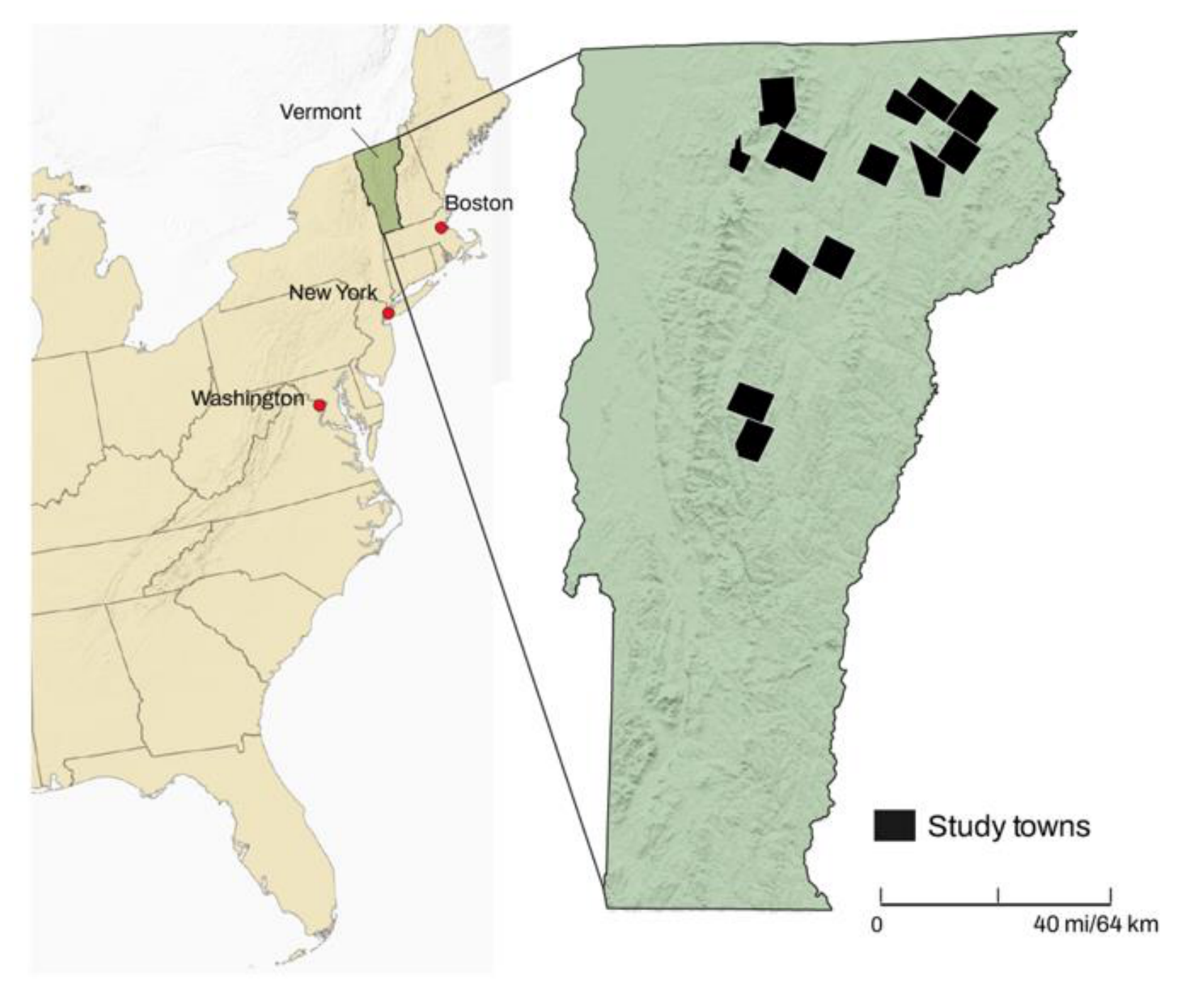
Figure 2.
a. The 13 case study towns showing high and highest priority interior forest (Data from the Vermont Center for Geographic Information 2025 [52], map by authors). b. Preserved land in Vermont, highlighting the 13 case study towns (Data from Vermont Center for Geographic Information 2025 [52], map by authors).
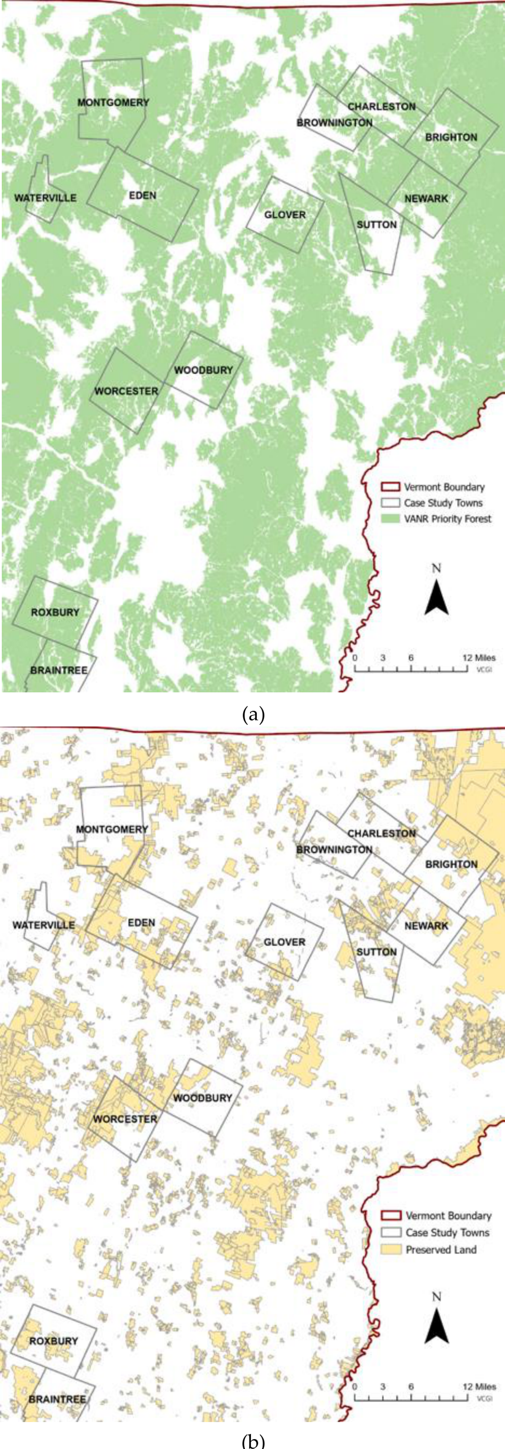
Table 1.
States with a 30X30 Goal.
| State | Year of 30X30 Goal Adoption | Percentage of State Land Area Preserved (2026) |
| California | 2020 – Governor’s Executive Order | 26.1% |
| Hawaii | 2016 - Hawaii Department of Land and Natural Resources | One goal applies to the waters of Hawaii. A second goal applies to watershed forests. 22% of watershed forests have been preserved. |
| Maine | 2020 and 2024 Climate Action Plan | 22% |
| Maryland | 2023 – State legislation: Maryland the Beautiful Act | 30% achieved in 2024 New goal is 40% by 2040 |
| Massachusetts | 2023 – Governor’s Executive Order and 2025 Biodiversity Conservation Goals for the Commonwealth | 28% Longer term goal is 40% by 2050 |
| Michigan | 2022- MI Healthy Climate Plan | 19.2% |
| Nevada | 2021 – State legislation/resolution | 15% |
| New Mexico | 2021 – Governor’s Executive Order | 6% |
| New York | 2022 – State legislation | 22% of land and waters |
| Vermont | 2023 – State legislation: Act 59 | 27% Longer term goal is 50% by 2050. |
Table 2.
Land Preserved in Vermont by Type, Acreage, and Percentage of the State.
| Land Type |
Acres (Hectares) Preserved |
Percentage of Vermont |
Percentage of Preserved Land |
| Forest | 929,000 (372,000 ha) |
16% | 57.1% |
| Ecological Reserve | 240,000 (96,000 ha) |
4% | 14.8% |
| Biodiversity Conservation Area | 236,000 (95,000 ha) |
4% |
14.6% |
| Farmland | 173,000 (70,000 ha) |
3% | 10.6% |
| Other | 48,000 (19,000 ha) |
1%< | 3.0% |
| TOTAL | 1,626,000 (652,000 ha) |
27% | 100% |
Source: VHCB, 2025, p. 46.
Table 3.
The Amount and Percentage of Preserved Land in the 13 Towns. Towns that have adopted a zoning ordinance are in bold.
Table 3.
The Amount and Percentage of Preserved Land in the 13 Towns. Towns that have adopted a zoning ordinance are in bold.
| Town | Total Acres | Acres Preserved | Percent Preserved | Percent of Preserved Land in Category 3** |
| Braintree | 24,670 | 5,252.1 | 21.3 | 98.0 |
| Brighton | 34,780 | 13,374.7 | *38.5 | 99.5 |
| Brownington | 18,149 | 1,024.1 | 5.6 | 71.9 |
| Charleston | 24,662 | 3,458.0 | 14.0 | 91.5 |
| Eden | 40,896 | 19,187.5 | *46.9 | 86.9 |
| Glover | 24,659 | 3,402.9 | 13.8 | 89.4 |
| Montgomery | 36,107 | 10,746.7 | *29.8 | 56.9 |
| Newark | 23,833 | 3,496.7 | 14.7 | 77.4 |
| Roxbury | 26,718 | 5,894.7 | 22.1 | 88.3 |
| Sutton | 24,633 | 4,680.6 | 19.0 | 80.9 |
| Waterville | 10,066 | 633.0 | 6.3 | 98.8 |
| Woodbury | 25,139 | 899.2 | 3.6 | 43.8 |
| Worcester | 24,784 | 11,869.2 | *47.9 | 73.3 |
* Denotes a town at or above the 30% threshold (with rounding). **Category 3 lands are designated as natural resource management areas, which are subject to long term land management, for example through farm and forestry operations. This is distinct from Category 1 (ecological reserves) and Category 2 (biodiversity areas) (Source: Vermont Agency of Natural Resources, 2024 [46]).
Table 4.
Acres Enrolled in the Current Use Program in the 13 Vermont Towns. Towns that have adopted a zoning ordinance are in bold.
Table 4.
Acres Enrolled in the Current Use Program in the 13 Vermont Towns. Towns that have adopted a zoning ordinance are in bold.
| Acres Enrolled in Current Use | Average Current Use Parcel Size | Percent of Town Enrolled in Current Use | Percent of Current Use Enrolled Working Lands that are Preserved | |
| Braintree | 17,070 | 137.7 | 69.2 | 30.1 |
| Brighton | 19,548 | 300.7 | 56.2 | 57.1 |
| Brownington | 6,337 | 181.1 | 34.9 | 5.6 |
| Charleston | 10,578 | 146.9 | 42.9 | 28.4 |
| Eden | 21,681 | 361.4 | 53.0 | 50.7 |
| Glover | 13,741 | 152.7 | 55.7 | 19.7 |
| Montgomery | 20,027 | 202.3 | 55.5 | 19.4 |
| Newark | 11,437 | 146.6 | 48.0 | 22.7 |
| Roxbury | 12,420 | 115.0 | 46.5 | 0.0 |
| Sutton | 7,686 | 130.3 | 31.2 | 25.5 |
| Waterville | 6,777 | 144.2 | 67.3 | 7.1 |
| Woodbury | 14,385 | 182.1 | 57.2 | 1.6 |
| Worcester | 14,382 | 149.8 | 58.0 | 26.0 |
Disclaimer/Publisher’s Note: The statements, opinions and data contained in all publications are solely those of the individual author(s) and contributor(s) and not of MDPI and/or the editor(s). MDPI and/or the editor(s) disclaim responsibility for any injury to people or property resulting from any ideas, methods, instructions or products referred to in the content. |
© 2026 by the authors. Licensee MDPI, Basel, Switzerland. This article is an open access article distributed under the terms and conditions of the Creative Commons Attribution (CC BY) license (http://creativecommons.org/licenses/by/4.0/).
Copyright: This open access article is published under a Creative Commons CC BY 4.0 license, which permit the free download, distribution, and reuse, provided that the author and preprint are cited in any reuse.