

Submitted:
08 October 2026
Posted:
10 October 2026
You are already at the latest version
Abstract
An interdisciplinary environmental baseline assessment was conducted on the submerged Roman remains of the Villa dei Pisoni, located within the Underwater Archaeological Park of Baiae (Poz-zuoli Bay, southern Italy), to characterize the physical and geochemical conditions that may influence the site’s long-term preservation. High-resolution morpho-bathymetric data were integrated with sedimentological and geochemical analyses performed at seven environmental stations surrounding the submerged villa. Sediments are predominantly composed of poorly sorted gravelly sand, indi-cating a shallow, wave-influenced depositional environment where sediment remobilization may contribute to mechanical abrasion of exposed archaeological surfaces. Organic geochemical analyses reveal a pronounced spatial heterogeneity in PAHs, with a maximum concentration of 3904 μg/kg at ENV_3, largely dominated by high-molecular-weight compounds. Diagnostic PAH ratios indicate a predominantly pyrogenic signature, suggesting a localized anthropogenic influence potentially re-lated to maritime activities and the proximity of the site’s mooring area, although a direct fuel-spill contribution cannot be demonstrated. Inorganic geochemical analyses identify a regional enrichment in As, consistent with the geochemical influence of the active Phlegraean hydrothermal system, to-gether with a distinct Cr–Ni–Rb anomaly at ENV_5, which is more consistent with local lithological and/or mineralogical controls. The results demonstrate that the environmental pressures affecting the site are inherently spatially heterogeneous and highlight the value of a holistic framework inte-grating sedimentological, geochemical, and high-resolution spatial data for the establishment of a comprehensive environmental baseline and the effective management of long-term preservation strategies.
Keywords:
environmental baseline
; marine environmental archaeology
; sediment geochemistry
; PAHs
; trace metals
; conservation monitoring
1. Introduction
Underwater Cultural Heritage (UCH) includes ancient shipwrecks, submerged ports, sunken cities and marine cultural landscapes. For archaeologists, these submerged sites provide unique, exceptionally well-preserved archives that show the evolution of human migration, commercial routes and help to trace human adaptations to past coastal changes. Typically, this heritage is safeguarded by coastal States under national legal systems that comply with international obligations [1,2]. Within the United Nations (UN) framework, the primary legal and ethical reference is the UNESCO 2001 [3] Convention on the Protection of the Underwater Cultural Heritage (CPUCH), which establishes binding guidelines to manage and safeguard these fragile resources, currently counting 82 States Parties [4]. At the state of the art, the integration of maritime archaeology into marine sciences is officially prioritized under the UN Decade of Ocean Science for Sustainable Development (2021–2030), in which Ocean Literacy is declared to be a prerequisite for sustainable marine governance by connecting scientific research with public memory and fruition [4].
Despite its immense scientific and cultural value, UCH remains significantly understimated in central mechanisms of global protection, such as the UNESCO World Heritage List [5]. Historically, this list has been constructed upon territorial models of State responsibility and jurisdiction that were not originally designed for submerged and offshore heritage case-studies [6]. A systematic analysis reveals that out of 1,223 World Heritage properties, at least 355 contain UCH elements (representing approximately 29% of the total), yet these elements are consistently marginalized, neglected in management plans, or categorized purely as terrestrial heritage [7]. This gap has been recognized by the World Heritage Centre’s World Heritage Marine Programme, established in 2005, and highlighted in the 2021 UNESCO Conference [3] on Identifying Critical Science Gaps, where UCH was formally identified as a critical knowledge gap for sustainable marine conservation [6,8]. Thus, as largely argued in recent times for iconic shipwrecks like the RMS Titanic [9,10], submerged sites possess Outstanding Universal Value (OUV) and must be systematically integrated into world heritage management systems to ensure a balanced and credible representation of human history [6]. Furthermore, UCH has been increasingly recognized as a vital ecological asset; submerged ruins and shipwrecks often function as artificial reefs and biodiversity refugia, facilitating a large ecological co-evolution and giving rise to the modern concepts of “shipwreck ecology” [11] and “maritime heritage ecology” [4,12].
Submerged archaeological resources are subjected to several, natural and anthropogenic stressors [13]. Natural agents of deterioration include physical, chemical, and biological processes that operate simultaneously on the seabed, [14] such are oceanographic currents and tides that may affect remains. Physical degradation is primarily driven by mechanical forces such as wave and current erosion, sediment displacement, and storms, which cause surface stress, fracturing, abrasion, and structural collapse [15]. This mechanical instability is increased by chemical and biological degradation (biodeterioration). In the marine environment, chemical degradation is almost always mediated by biological activity. These natural pressures are heavily intensified by modern anthropogenic hazard factors, including coastal expansion, dredging, unregulated tourism, robbing, bottom-trawl fishing, and the rapid growth of the offshore Blue Economy, as well as the local marine pollution that may increase the bio-geochemical processes on a site [4,16]. Consequently, the preservation of UCH has been recognized as a core directive of global sustainability, to protect and safeguard the human cultural and natural heritage [17] in light of an holistic vision, that takes into account heritage sites like a live dynamic centers subjected to external stressors from both natural and anthropogenic stressors.
It’s a matter of fact that UCH conservation depends primarily on the ability to locate, document, and map submerged landscapes with high precision. Over the last sixty years, underwater archaeology has transitioned from pioneering photogrammetric mapping of shallow sites, such as the 7th-century AD Yassi Ada wreck at 40 meters depth [18], to utilizing highly sophisticated autonomous systems, marine robotics, and digital imaging sensors [19]. Recent reviews provide broad overviews of unmanned underwater robotics and imaging sensors [20,21,22], underwater photogrammetric applications on marine archaeological sites [23,24,25,26,27], optical imaging and processing of underwater datasets [28,29,30,31]. To date, the combined use of multiple techniques [32,33] seem to be the most promising, together with detailed image surveys, for a comprehensive view and mapping UCH site. 3D documentation serves as a scientifically rigorous foundation for virtual and augmented reality (VR/AR) systems [34]. Such digital twins and virtual democratize public access, allowing remote interactive tours and enhanced digital exploration without risking the physical integrity of the fragile remains [35,36,37,38]. This study presents a comprehensive environmental characterization of the Villa dei Pisoni archaeological site, located within the Underwater Archaeological Park of Baiae, with the objective of establishing a robust environmental baseline. By integrating high-resolution spatial mapping with physical, chemical, and biological investigations, the study provides an updated assessment of the environmental factors that may influence the preservation of the submerged archaeological remains. The resulting baseline constitutes a scientific foundation for evaluating future conservation trajectories and for guiding evidence-based management, monitoring, and preservation strategies.
2. Site Background
2.1. The Campi Flegrei Caldera
The Campi Flegrei district is an active volcanic caldera located in the western sector of the Campania region (southern Italy; Figure 1A). Structurally, it is characterized by a complex nested caldera structure, which spans a terrestrial area of approximately 200 sq. km densely populated by over 500,000 people, and a marine portion represented by the Gulf of Pozzuoli [39,40,41].
The geological evolution of this active volcanic field has been structurally dominated by two major caldera-forming ignimbrite eruptions: the first, associated with the eruption of the Campania Ignimbrite (CI; Figure 1B) dated at ~39 ka BP, which ejected approximately 100–200 km3 of dense rock equivalent (DRE) pyroclastic products [42,43] and the second, associated with the eruption of the Neapolitan Yellow Tuff (NYT; Figure 1B) dated at ~15 ka BP, which ejected 30–50 cubic km DRE of ignimbrite, creating the current circular depression of approximately 8 km in diameter [41,44,45]. Following the NYT event, subaerial and submerged activity continued with at least 70 explosive and hydromagmatic eruptions, leading to the formation of monogenetic tuff cones, tuff rings, and lava domes, with prominent post-caldera events such as the Plinian Agnano-Pomici Principali eruption (~10 ka BP) and the Agnano-Monte Spina eruption (~4.1 ka BP) [46]. The historical eruptive activity concluded with the eruption of Monte Nuovo in 1538 AD, which ejected 0.03 km3 of volcanic products, creating a new tuff cone that drastically alterated the morphology of the western coastal sector of Pozzuoli Bay [47].
The magmatic and hydrothermal systems of the Campi Flegrei caldera remain highly active. Petrological and geophysical modeling indicates the presence of a sill-like hydrothermal reservoir of fluids located at a shallow depth of 3–4 km, connected to a deeper feeding magma chamber positioned at approximately 8 km depth [48,49]. This deep-seated system drives intense soil degassing, seismic swarms, and hydrothermal vents concentrated around the Solfatara crater and the Pisciarelli degassing zones [50]. In the marine domain of Pozzuoli Bay, this magmatic activity is expressed through numerous Active Fluid Vents (AFV), which release mineral-rich hydrothermal gases and hot water directly into the water column [46]. Furthermore, the caldera is historically characterized by bradyseism, a phenomenon consisting of slow, massive vertical ground movements (cycles of rapid uplift and progressive subsidence) triggered by sub-surface fluid migration and pressure changes. Modern manifestations of this phenomenon include the bradyseismic crises of 1969–1972 and 1982–1984, which generated a net vertical ground uplift of up to 3.5 m in the town of Pozzuoli, accompanied by low-magnitude microseismicity [46 and references therein]. A subsequent uplift phase initiated in November 2004 has continued to cause progressive deformation across the entire coastal and marine area. This latter crise of unrest is still ongoing at the present.
2.2. Historical and Archaeological Evolution of Submerged Baiae
During the Roman Republican and Imperial periods, the exceptional climate of the area, as well as the presence of thermal waters and beautiful coastal landscape made the Phlegraean coast one of the most affected resorts for the Roman aristocracy [34]. The settlement of Baiae developed rapidly from the Late Republic (2nd–1st Century BC) into a monumental residential center, frequented by the most prominent figures of Rome, including Julius Caesar, Pompey the Great, and Marcus Antonius [34]. Under Augustus and his imperial successors, vast portions of the coastal landscape were systematically transformed into imperial properties and luxurious villas. This period witnessed extraordinary achievements in Roman maritime concrete engineering, utilizing the localized volcanic ash known as pulvis puteolanum (pozzolana). This material possessed hydraulic properties that allowed concrete to harden underwater, enabling Roman architects to construct massive artificial piers, fishponds, residential platforms, and breakwaters directly in the sea, significantly modifying the natural coastline [38].
This intensive anthropization came to an end due to the tectonic instability of the caldera. Starting from the end of the 4th Century and the beginning of the 5th Century AD, a major subsidence phase associated with the bradyseismic sinking of the caldera floor, coupled with post-glacial eustatic sea-level rise, initiated the progressive submersion of the low-lying coastal structures. The coastline receded by several hundred meters, drowning Roman palaces, thermal baths, villas, and port infrastructures beneath 2 to 15 m of seawater [51]. Today, this submerged archaeological heritage is protected within a Marine Protected Area (MPA) established in 2002.
2.3. Villa dei Pisoni
High-resolution underwater surveys have revealed a complex, drowned Roman landscape organized into distinct domestic and public complexes. The Villa dei Pisoni (Pisonian Villa), in particular, covers a massive area off the promontory in front of Punta Epitaffio, this luxury maritime villa has been dated from the Late Republican period with successive renovations extending to the 2nd Century AD (Hadrianic era) [38]. The villa features a monumental rectangular layout measuring 160 x 120 meters (Figure 2A and Figure 2B), oriented along a N80E strike. Its interior was dominated by a large, central open-air garden (viridarium) measuring 95 x 65 m, surrounded by a portico marked by half-columns, semicircular and square niches, and an elaborate quadriporticus. Seaward, the villa comprised private thermal bath complexes, fish storage tanks, and a grand residential block ending in a large terrace. To the south, a protective breakwater system composed of several massive concrete pillars (pilae) was erected to shield the villa’s private harbor from south-easterly winds [38].
2.4. Morphobathymetry and Subsidence Rates
The application of modern, high-resolution remote sensing and morpho-bathymetric surveys has allowed for the quantitative reconstruction of Pozzuoli Bay’s marine landscape. Airborne Laser Scanning (ALS) and multi-resolution multibeam echo-sounder surveys have yielded a seamless land-sea Digital Elevation Model (DEM) with a spatial resolution of 1 m, covering a total area of 138.32 sq. km [46]. This model maps submerged terraces at depths of 7 m, 22 m, 37 m, 76 m, 101 m, and 116 m bsl, representing ancient coastal still-stands and phases of dynamic tectonic-eustatic equilibrium [45]. It also identifies prominent hazard-related marine features, including underwater landslide detachment scarps near Secca delle Fumose, representing a potential threat to the stability of the archaeological remains.
3. Data and Methods
3.1. High Resolution Bathymetric Data
Ultra-high-resolution bathymetric data were acquired within the framework of the EU NERITES project using a NORBIT WINGHEAD B51S multibeam echosounder (MBES) installed on the compact DEVSS autonomous surface vehicle (ASV), developed by 3D Research S.r.l. The compact dimensions, shallow draft, and high manoeuvrability of the platform were particularly suited to surveying the shallow archaeological area, enabling low-speed navigation along closely spaced survey lines while minimizing disturbance and allowing close-range mapping of the submerged structures. The MBES was operated at approximately 700 kHz, using 1024 beams per ping over a swath sector of approximately 90°, with an adaptive ping rate of 30–50 Hz. Survey lines were acquired at an average speed of approximately 2.5–3.0 knots and with a line spacing of approximately 3–5 m, providing substantial overlap between adjacent swaths and ensuring high sounding density and redundant seabed coverage throughout the archaeological area. Position and attitude data were provided by an Applanix OceanMaster GNSS/INS system, which supplied vessel position, heading, roll, pitch, and heave information for accurate georeferencing and motion compensation of individual soundings. Sound-speed variability throughout the water column was characterized using sound-velocity profiles (SVPs) acquired during the survey with an AML Oceanographic SVP probe and subsequently applied during bathymetric processing. Following positioning, motion, sound-velocity, and tidal corrections, the bathymetric dataset was subjected to quality control and sounding filtering before being gridded to generate a digital terrain model (DTM) of the Villa dei Pisoni area with a spatial resolution of 0.10 m. The resulting high-resolution DTM provided a detailed representation of both the submerged archaeological structures and the surrounding seabed morphology, forming the spatial framework for the georeferencing of the environmental sampling stations and for interpreting their spatial relationships with local morphological features.
3.2. Sampling Design and Geospatial Positioning
To evaluate the geochemical, sedimentological, and degradation dynamics of the submerged Roman structures at the Villa dei Pisoni, a systematic, integrated sampling design was implemented in the northeast sector of the bay. All marine operations were conducted at shallow water depths (less than 10 meters below sea level). To ensure a highly representative spatial coverage, a total of seven environmental stations (designated Env_1 to Env_7; Figure 3) were established. All sampling points were georeferenced with sub-decimeter precision using a differential GNSS system. Specifically, during the 2023 bathymetric and sampling campaigns, positioning was acquired using a Stonex GNSS S990A system equipped with an Inertial Measurement Unit (IMU) to facilitate measurements in morphologically complex environments with inclinations of up to 60 degrees. The coordinate network was defined under the WGS84 Geodetic Datum and projected in the UTM Zone 33N cartographic system.
3.3. Sample Collection
At each environmental station, scientific divers collected paired surface marine sediment and seawater samples using rigorous contamination-free protocols. Seawater organic compound samples (for PAHs, PCBs, OCPs, nutrients, and total suspended solids) were collected directly from a manually locked Niskin bottle into amber glass or high-density polyethylene (HDPE) bottles, previously rinsed three times with the sample water. Samples were sealed immediately and stored in the dark at -20 °C. For volatile organic compounds (VOCs), three headspace vials were filled directly from the Niskin bottle with exactly 10 mL of water, immediately crimp-sealed, and stored in the dark at -20 ° C. Seawater trace metals were collected directly from the Niskin bottle using pre-cleaned HDPE bottles that had undergone an aqueous nitric acid wash, and stored in the dark at -20 °C. Surface sediments were collected from the upper 5 cm of the seabed. Sediment for organic chemical analyses was sealed in decontaminated HDPE containers and stored at -18 degrees C. For VOC/BTEX analysis, approximately 5 grams of fresh sediment was introduced into three headspace vials using a clean metal spatula, preserved with 10 mL of a saturated NaCl solution containing 0.2% phosphoric acid, immediately crimped, and stored at -20 degrees C. Sediment samples for grain size analysis were stored in hermetically sealed plastic bags at +4 ° C.
3.4. Sedimentological Analysis
Sedimentological analyses were carried out at the CNR laboratories using a representative wet sediment aliquot of 100–200 g per sample. Samples were oven-dried at 105 degrees C for 24 hours to achieve constant dry weight. To remove organic cements and facilitate deflocculation, the dry sediments were treated with a 30% hydrogen peroxide solution diluted 1:4 with distilled water for 24–48 hours, followed by extensive rinsing with distilled water. The treated samples were wet-sieved through a 63 micrometer ASTM standard mesh to separate the coarse fraction (>63 micrometers) from the fine fraction (<63 micrometers). After drying, the coarse fraction was dry-sieved using a mechanical shaker and a nested stack of ASTM standard sieves ranging from 4000 micrometers to 63 micrometers. The fine fraction was dry-quartered, dispersed in a 0.05% sodium hexametaphosphate solution for 24 hours to prevent re-aggregation, and analyzed using a Helos/Quixel Sympatec laser particle-size analyzer. Key statistical parameters, like mean size, sorting, skewness, and kurtosis, were calculated in phi units using the graphic formulas proposed by Folk and Ward [52].
3.5. Geochemical Analyses
Organic pollutants in seawater (PAHs, PCBs, OCPs) were extracted following EPA Method 3545 (Pressurized Fluid Extraction) using a 47 mm membrane disk loaded with a C18 octadecyl silica sorbent phase. During extraction, water samples were spiked with a deuterated surrogate standard mixture. The extraction method was performed following five steps: cleaning, conditioning, extraction, elution, and drying, Final extracts were recovered in 100 microliters of internal standard solution and analyzed via gas chromatography-mass spectrometry (GC/MS) in Selective Ion Monitoring (SIM) mode (for PAHs) and gas chromatography-tandem mass spectrometry (GC/MS-MS) in Ion Trap mode (for PCBs and OCPs), following EPA Methods 8270D, 8081, and 8082A respectively. For surface sediments, a 2.0 g dried and homogenized sample aliquot was spiked with a deuterated surrogate standard mixture, subjected to ultrasonic extraction with a hexane/acetone (80:20 v/v) mixture following EPA Method 3550C, purified via Solid-Phase Extraction (SPE) cartridges containing 6 g of deactivated silica gel (for PAHs) and 6 g of Florisil ® (for chlorinated compounds), concentrated to 400 microliters, spiked with internal standards, and analyzed via GC/MS in SIM mode (for PAHs) and GC-Ion Trap MS-MS (for PCBs and OCPs). VOCs and BTEX in seawater and sediments were determined using equilibrium headspace gas chromatography following EPA Method 5021A. Sediment inorganic element composition was determined on dried, homogenized, and sieved samples using a field-portable X-ray fluorescence spectrometer (FP-XRF) following the protocols of EPA Method 6200.
4. Results
4.1. Sedimentological and Physical Characteristics of Surface Sediments
The sedimentological and physical properties of the surface sediments collected across the seven environmental stations (Env_1 to Env_7) show a remarkably uniform textural classification. According to the Wentworth [53] scale and the Folk and Ward classification scheme [52], all analyzed samples are categorized as gravelly sand. Textural analysis reveals that the sediment matrix is heavily dominated by the sand fraction, which ranges from 53.95% at station Env_6 to 79.37% at station Env_5 (Figure 4 and Table 1). The gravel fraction represents the second most abundant component, varying from 20.53% (Env_5) up to 46.00% (Env_6). In contrast, the fine-grained fractions are virtually absent: silt content is extremely low, ranging from a minimum of 0.05% (Env_6) to a maximum of only 1.19% (Env_1), while the clay fraction is completely absent (0.00%) at all stations except for a negligible trace of 0.04% detected at station Env_3
Statistical grain-size parameters calculated using the Folk and Ward [52] graphic method provide further insights into the depositional environment. Mean graphic sizes range from -0.09 phi (Env_5) to -0.87 phi (Env_6), corresponding to very coarse sand. Sorting values range between 0.96 phi (Env_4, moderately sorted) and 1.60 phi (Env_3, poorly sorted), showing poor to moderate sorting typical of wave-influenced infralittoral zones. Skewness is predominantly positive (+0.06 to +0.46), pointing to a tail of finer material, with the exception of Env_5, which is slightly negatively skewed (-0.08). The kurtosis values vary widely, from a leptokurtic 2.62 at Env_6 to an extremely leptokurtic 6.18 at Env_1. (Table A1 in Appendix A).
4.2. Organic Geochemistry
Sediments analysis reveal highly localized and severe accumulation of organic contaminants. The PAH sum in sediments exhibits extreme spatial heterogeneity, ranging over nearly three orders of magnitude, from a low baseline of 8.08 μg/kg at Env_5 to a massive 3904 μg/kg at station Env_3 (Table 2). Elevated concentrations are also recorded at Env_1 (504 μg/kg) and Env_7 (378 μg/kg). The high PAH concentration at Env_3 is heavily driven by high-molecular-weight compounds: Fluoranthene reaches 1,204.0 μg/kg, Pyrene is present at 693.6 μg/kg, and Benzo(b+k)fluoranthene exhibits a concentration of 558.3 μg/kg. PCBs are also detected, peaking at Env_3 (1.51 μg/kg) and Env_1 (1.26 μg/kg) (Table A2 in Appendix A).
4.3. Inorganic Analysis (FP-XRF)
Field-portable X-ray fluorescence (FP-XRF) screening of the surface sediments reveals highly distinctive geochemical patterns. The trace element profile across all stations is dominated by exceptionally high concentrations of Arsenic, ranging from 115 mg/kg (Env_7) to 196 mg/kg (Env_6), significantly exceeding typical coastal marine sediment baselines (Table 3) . This regional enrichment is a direct geochemical signature of the active Phlegraean hydrothermal system, where arsenic-rich, high-temperature volcanic fluids are continuously discharged through submarine vents directly into Pozzuoli Bay. Potassium (16–26 g/kg), Iron (21–30 g/kg), Titanium (908–1321 mg/kg), and Manganese (541–745 mg/kg) represent the typical natural trachytic and phonolitic mineral background of Phlegraean pyroclastic deposits.
Station Env_5 represents a geochemical anomaly, characterized by a stark multielemental enrichment of Chromium (422 mg/kg compared to a tight baseline of 21–30 mg/kg at all other stations), Nickel (74 mg/kg compared to a baseline of 18–26 mg/kg), and Rubidium (1,540 mg/kg compared to a baseline of 157–764 mg/kg) . Finally, a strong geochemical correlation is observed between Calcium and Strontium across the transect, with the highest Ca concentrations at Env_1 (284 g/kg) and Env_7 (243 g/kg) directly correlating with the highest Strontium levels of 1,501 mg/kg and 1,420 mg/kg respectively, reflecting the chemical dispersion of calcium-rich Roman concrete structures (Table 3).
To achieve long-term, adaptive management of submerged artifacts, physical mapping must be coupled with a deep, quantitative understanding of the surrounding marine environment. Underwater cultural assets do not exist as isolated objects but are integrated into a dynamic, 3D system where archaeological materials, sediments, and biochemical processes are intrinsically linked [4]. Here, Marine Environmental Archaeology (MEA) and geochemical monitoring provide the empirical tools necessary to assess and predict material degradation rates.
Figure 5.
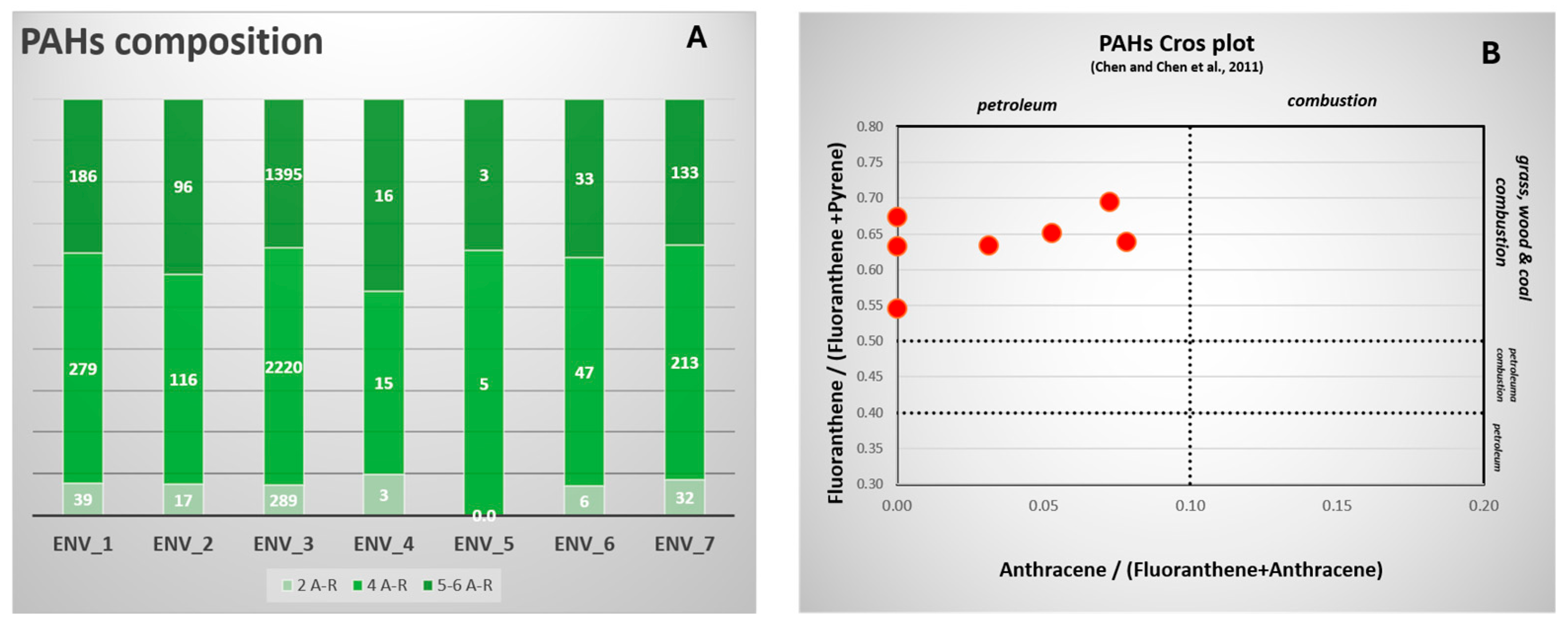
PAH composition. A) Light vs. Heavy diagnostic ratios (2, 4 and 5-6 AR) B) PAHs diagnostic cross-plot.
Figure 5.
PAH composition. A) Light vs. Heavy diagnostic ratios (2, 4 and 5-6 AR) B) PAHs diagnostic cross-plot.
5. Discussion
5.1. Organic Compounds of the Anthropogenic Impact
The distribution of polycyclic aromatic hydrocarbons (PAHs) in sediment samples offers valuable insight into the contamination patterns at the Villa dei Pisoni site. Among the stations investigated, ENV_3 stands out for its markedly higher total PAH concentration (ΣPAHs = 3904 μg/kg; Table 2), with a composition dominated by high-molecular-weight compounds, particularly fluoranthene (1204.0 μg/kg), pyrene (693.6 μg/kg), benzo(b+k)fluoranthene (558.3 μg/kg), benzo(a)anthracene (256.9 μg/kg), and benzo(a)pyrene (275.2 μg/kg) (Table A1 in Appendix A). Diagnostic molecular ratios are numerical values derived from the relative abundances of selected PAH isomers sharing the same molecular mass [54]. These ratios are commonly used in environmental geochemistry as empirical tools to distinguish between different contamination sources, most notably between pyrogenic (combustion-derived, e.g., fossil fuel or biomass burning) and petrogenic (petroleum-derived, e.g., crude oil or fuel spills) origins. Common examples include: Ant/(Ant+Phe), that distinguishes petrogenic (low values) from pyrogenic (higher values) sources; Flu/(Flu+Pyr), in which values > 0.5 typically indicate combustion (grass, wood, or coal), while < 0.5 suggest petroleum, BaA/(BaA+Chr) , where ratios > 0.35 are associated with pyrogenic inputs and IcdP/(IcdP+BghiP), that helps differentiate between liquid fossil fuel combustion and other pyrogenic sources [55,56].
Diagnostic molecular ratios further support a predominantly pyrogenic origin at ENV_3: Ant/(Ant+Phe) = 0.134, Flu/(Flu+Pyr) = 0.634, BaA/(BaA+Chr) = 0.796, and IcdP/(IcdP+BghiP) = 0.531 [57]. These values, together with the strong prevalence of four- to six-ring PAHs over lower-molecular-weight homologues, point to combustion-derived inputs rather than a fresh petrogenic source, such as a recent fuel spill. Notably, the light hydrocarbon fraction (C<12) was below the detection limit at ENV_3, further distancing the signature from that of raw petroleum products. This combination of heavy PAH dominance and localized volatile hydrocarbon enrichment suggests a distinct petroleum-derived organic signature, yet one that is heavily weathered or combustion-altered. In the context of the Marine Protected Area, this contamination is plausibly linked to tourist infrastructure. In fact, ENV_3 lies in close proximity to the mooring buoy system used to anchor vessels during guided dives at the Villa dei Pisoni. Boats tethered to these buoys are the most likely source of minor fuel, lubricant, or exhaust residues. Due to the coarse, gravelly sand texture of the sediment and the presence of topographic depressions near the ruins, these small, trace hydrocarbon releases—associated with routine vessel operations—have accumulated over decades. Their hydrophobic nature promotes binding to sediment particles, leading to high concentrations in sheltered pockets.
Nevertheless, while the proximity of ENV_3 to the mooring area suggests a possible boating influence, the PAH fingerprint does not align with a simple, fresh fuel-spill signature. Instead, the contamination likely reflects a more complex anthropogenic input, possibly related to combustion emissions from maritime traffic, with subsequent sedimentary accumulation. It should be noted that samples ENV_1 and ENV_3 are the most enriched in organic compounds, also due to their grain size, with a greater presence of silt. It is well known that organic particles are able to bind more to the finer portion of the sediment. This would explain why these two locations appear to be more polluted. Moreover, diagnostic ratios should be interpreted with caution, as mixing among sources and post-depositional processes, such as degradation and transport that can alter the original signal. Therefore, the set of PAHs at ENV_3 should be considered more as evidence of a strong anthropogenic influence, predominantly pyrogenic, rather than as definitive evidence of point-site oil contamination.
5.2. Metal Anomaly at ENV_5 Sample Station
In contrast to ENV_3, where the most pronounced anomaly is associated with PAHs, ENV_5 is characterized by a distinct inorganic geochemical signature. The most remarkable feature is the strong enrichment in Cr, which reaches 422 mg/kg, compared with values ranging between 21 and 30 mg/kg at the other stations (Table 3). This anomaly is accompanied by elevated Ni (74 mg/kg), whereas the concentrations of most of the other potentially anthropogenic trace elements remain within the range observed across the study area. In addition, ENV_5 shows a markedly higher Rb concentration (1540 mg/kg) than the other stations, which range from 157 to 764 mg/kg, further distinguishing this sample from the general geochemical variability of the site (Table 3). The concomitant occurrence of Cr, Ni, and Rb suggests that the anomaly is not associated with a generalized enrichment of trace metals, but rather with a specific geochemical component. The strong Cr–Ni association, in particular, may be consistent with the contribution of a specific sedimentary component, although the available data do not allow its precise mineralogical source to be identified. Conversely, the absence of a corresponding enrichment in PAHs at ENV_5 suggests that this inorganic anomaly is spatially and geochemically decoupled from the strong organic contamination observed at ENV_3 (Table 2). The interpretation of trace-element distributions in submerged archaeological sediments should also consider the potential contribution of archaeological materials themselves. In particular, pigment-bearing fragments derived from mosaics, painted surfaces, glass tesserae, mortars, and other decorative materials may locally contribute specific chemical elements to the surrounding sediment. Roman pigments commonly included Fe-bearing ochres, Cu-bearing malachite, azurite and Egyptian blue, as well as Pb- and Hg-bearing pigments such as minium and cinnabar [58]. Therefore, localized elemental enrichments should not necessarily be interpreted exclusively as evidence of modern anthropogenic contamination, particularly in areas where archaeological debris may accumulate.
5.3. Potential Hydrodynamic Controls on Material Degradation
The sedimentological properties of the site play a fundamental role in controlling the physical degradation rates of the ruins, acting as a natural buffer or catalyst in the SFP model. At Baia, the sediment is classified as a poorly sorted, very coarse gravelly sand with a low silt and clay content. This coarse sediment distribution is characteristic of a shallow, wave-influenced infralittoral zone. While coarse sand can act as a protective blanket when completely burying ruins, wave-induced bottom currents and orbital velocities can trigger sediment remobilization. When sediment resuspension occurs, the hard, coarse grains cause direct mechanical abrasion on exposed stone and mortar surfaces, acting as a physical scrambling device (REF.?). This mechanical stress is particularly intense around the edges of reefs and elevated structures, stripping away protective biological concretions or natural corrosion layers. This relationship is clearly demonstrated by empirical electrochemical data from comparable historical iron sites (REF.): at. At the Villa dei Pisoni (lying at similar depths of 4.8 to 6.9 m bsl), localized hydrodynamic forces similarly govern structural wear, highlighting the need to understand sediment transport vectors to predict the long-term survival of the ruins.
6. Conclusions
The interdisciplinary investigation of the Villa dei Pisoni within the Submerged Archaeological Park of Baiae establishes a comprehensive environmental baseline for deciphering the complex interactions between geological, oceanographic, and anthropogenic processes operating in an active volcanic coastal environment. The integration of high-resolution georeferenced bathymetry, close-range photogrammetry, sedimentological analyses, and organic and inorganic geochemistry provides a holistic framework for evaluating the environmental controls on the long-term preservation of the submerged Roman remains and supports the development of informed conservation and management strategies.
The sedimentological results demonstrate that the seabed at the site is composed of an exceptionally uniform gravelly sand matrix, which represents a highly dynamic shallow-water environment. While this coarse sediment serves to naturally bury and protect several structures, it simultaneously acts as an agent of intense physical wear. Wave-induced bottom orbital currents trigger continuous sediment resuspension, causing severe mechanical abrasion on exposed archaeological stones, plasters, and concrete breakwaters. Geochemically, the surface sediments host severe, highly localized contaminant anomalies. The extreme concentration of polycyclic aromatic hydrocarbons and light hydrocarbons at station Env_3 points directly to a petroleum-derived signature. This organic stress is closely correlated with the proximity of the tourist mooring buoy system, where authorized visitation vessels release small, trace amounts of fuel and lubricants. Although these quantities are small and trace in nature, their accumulation in the low-lying sediment pockets adjacent to the ruins presents a localized chemical stress that must be monitored. On the contrary, ENV_5 displayed a distinct inorganic geochemical signature, characterized by marked Cr–Ni–Rb enrichment. This pattern, in contrast to the PAH-dominated anomaly observed at ENV_3, is more consistent with a local lithological and/or mineralogical control, likely linked to the presence of pigments in erratic fragments, rather than a generalized anthropogenic contamination source. Furthermore, the regional sediment baseline is characterized by geothermal Arsenic enrichment, a natural volcanic fingerprint driven by active fluid vents discharging mineral-rich hydrothermal fluids directly on the seabed of Pozzuoli Bay. This baseline study demonstrates that the integration of marine environmental archaeology and geochemical monitoring provides an essential framework for the development of proactive and adaptive management strategies, supporting the long-term conservation, documentation, and sustainable management of the submerged cultural heritage of Baiae.
Author Contributions
Conceptualization, S.P., C.S.P. and A.L..; methodology, M.V., S.T., S.G. and S.P..; formal analysis, U.S., .S.G. and M.C.; investigation, S.P., A.L.. and U.S..; data curation, S.G., M.V., M.C. and F.B..; writing—original draft preparation, All authors; supervision, F.B and B.D.P. project administration, F.B., funding acquisition, S.P., F.B. and B.D.P. All authors have read and agreed to the published version of the manuscript.
Funding
This research was funded by the EU project NERITES, grant number 101132575.
Data Availability Statement
Geochemical results are all included in the tables. Multibeam data are available on demand. Please, write to salvatore.passaro@cnr.it.
Acknowledgments
We would like to sincerely thank Enzo Maione from the Centro Sub Campi Flegrei for his dedication and outstanding support. Our gratitude also goes to Second-class Chief Marco d’Angiolella, Commander of the Port Authority of Baia, for his extraordinary helpfulness, kindness, and professionalism. Their invaluable contributions were essential to the successful execution of the operational activities.
Conflicts of Interest
The authors declare no conflicts of interest.
Appendix A

Table A1.
Statistical and physical parameters of surface sediments at Villa dei Pisoni.
| Station ID | Mz mean graphic size |
σ sorting |
Ski skewness |
KG kurtosis |
Water (%) | Density (g/cm³) | CaCO3 (%) |
|---|---|---|---|---|---|---|---|
| Env_1 | -0.36 | 1.24 | 0.46 | 6.18 | 39.11 | 2.55 | 5.60 |
| Env_2 | -0.43 | 1.28 | 0.26 | 4.15 | 26.55 | 2.56 | 5.22 |
| Env_3 | -0.49 | 1.60 | 0.35 | 3.58 | 48.08 | 2.55 | 5.22 |
| Env_4 | -0.51 | 0.96 | 0.06 | 4.02 | 0.55 | 2.55 | 5.41 |
| Env_5 | -0.09 | 1.19 | -0.08 | 3.14 | 34.35 | 2.55 | 5.41 |
| Env_6 | -0.87 | 1.18 | 0.14 | 2.62 | 29.89 | 2.55 | 5.60 |
| Env_7 | -0.49 | 1.29 | 0.06 | 2.74 | 40.95 | 2.55 | 5.60 |
Table A2.
Results of the organic chemistry data analysis.
| A/A | PARAMETER | METHOD | UNIT | LIMIT | Env_1 | Env_2 | Env_3 | Env_4 | Env_5 | Env_6 | Env_7 |
| 1 | Fluorene | EPA 3550C - EPA 3630C - EPA 8270D - EPA 8081 | mg/kg | 2 | <LOQ | <LOQ | <LOQ | 3.4 | <LOQ | <LOQ | 2.2 |
| 2 | Phenanthrene | EPA 3550C - EPA 3630C - EPA 8270D - EPA 8081 | mg/kg | 2 | 29.1 | 13.9 | 249.9 | <LOQ | <LOQ | 6.1 | 22.5 |
| 3 | Anthracene | EPA 3550C - EPA 3630C - EPA 8270D - EPA 8081 | mg/kg | 2 | 9.5 | 3.1 | 38.8 | <LOQ | <LOQ | <LOQ | 7.6 |
| 4 | Fluoranthene | EPA 3550C - EPA 3630C - EPA 8270D - EPA 8081 | mg/kg | 2 | 112.2 | 55.1 | 1204.0 | 6.4 | 2.8 | 23.4 | 97.6 |
| 5 | Pyrene | EPA 3550C - EPA 3630C - EPA 8270D - EPA 8081 | mg/kg | 2 | 63.4 | 29.4 | 693.6 | 3.1 | 2.3 | 13.6 | 42.8 |
| 6 | Benzo(a)anthracene | EPA 3550C - EPA 3630C - EPA 8270D - EPA 8081 | mg/kg | 2 | 41.7 | 12.0 | 256.9 | 2.1 | <LOQ | 7.6 | 30.6 |
| 7 | Chrysene | EPA 3550C - EPA 3630C - EPA 8270D - EPA 8081 | mg/kg | 2 | 61.8 | 19.4 | 65.9 | 3.5 | <LOQ | 2.5 | 42.0 |
| 8 | Benzo(b+k)fluoranthene | EPA 3550C - EPA 3630C - EPA 8270D - EPA 8081 | mg/kg | 2 | 73.0 | 37.8 | 558.3 | 7.1 | 2.9 | 14.0 | 57.1 |
| 9 | Benzo(j)fluoranthene | EPA 3550C - EPA 3630C - EPA 8270D - EPA 8081 | mg/kg | 2 | 24.5 | 13.6 | 217.0 | 2.8 | <LOQ | 4.6 | 17.4 |
| 10 | Benzo(e)pyrene | EPA 3550C - EPA 3630C - EPA 8270D - EPA 8081 | mg/kg | 2 | 28.5 | 16.3 | 207.7 | 3.4 | <LOQ | 6.0 | 21.4 |
| 11 | Benzo(a)pyrene | EPA 3550C - EPA 3630C - EPA 8270D - EPA 8081 | mg/kg | 2 | 38.4 | 18.5 | 275.2 | 2.4 | <LOQ | 5.4 | 22.6 |
| 12 | Perylene | EPA 3550C - EPA 3630C - EPA 8270D - EPA 8081 | mg/kg | 2 | 13.8 | 7.5 | 97.8 | <LOQ | <LOQ | 2.7 | 9.9 |
| 13 | Indeno(1,2,3-c,d)pyrene | EPA 3550C - EPA 3630C - EPA 8270D - EPA 8081 | mg/kg | 2 | 3.2 | <LOQ | 17.3 | <LOQ | <LOQ | <LOQ | 2.1 |
| 14 | Dibenzo(a,h)anthracene | EPA 3550C - EPA 3630C - EPA 8270D - EPA 8081 | mg/kg | 2 | 1.2 | <LOQ | 6.6 | <LOQ | <LOQ | <LOQ | <LOQ |
| 15 | Benzo(g,h,i)perylene | EPA 3550C - EPA 3630C - EPA 8270D - EPA 8081 | mg/kg | 2 | 3.4 | 2.7 | 15.3 | <LOQ | <LOQ | <LOQ | 2.0 |
| 16 | SUM | mg/kg | 504 | 229 | 3904 | 34.3 | 8.08 | 85.9 | 378 | ||
| 16 | PCB28_tri1 | EPA 3550C - EPA 3620C | mg/kg | 0.25 | <LOQ | <LOQ | <LOQ | <LOQ | <LOQ | <LOQ | <LOQ |
| 17 | PCB52_tetra1 | EPA 3550C - EPA 3620C | mg/kg | 0.25 | <LOQ | <LOQ | <LOQ | <LOQ | <LOQ | <LOQ | <LOQ |
| 18 | PCB101_penta1 | EPA 3550C - EPA 3620C | mg/kg | 0.25 | <LOQ | 0.55 | <LOQ | <LOQ | <LOQ | 0.39 | <LOQ |
| 19 | PCB81_tetra2 | EPA 3550C - EPA 3620C | mg/kg | 0.25 | <LOQ | <LOQ | <LOQ | <LOQ | <LOQ | <LOQ | <LOQ |
| 20 | PCB77_tetra3 | EPA 3550C - EPA 3620C | mg/kg | 0.25 | <LOQ | <LOQ | <LOQ | <LOQ | <LOQ | <LOQ | <LOQ |
| 21 | PCB118_penta2 | EPA 3550C - EPA 3620C | mg/kg | 0.25 | <LOQ | <LOQ | <LOQ | <LOQ | <LOQ | <LOQ | <LOQ |
| 22 | PCB114_penta3 | EPA 3550C - EPA 3620C | mg/kg | 0.25 | <LOQ | <LOQ | <LOQ | <LOQ | <LOQ | <LOQ | <LOQ |
| 23 | PCB123_penta4 | EPA 3550C - EPA 3620C | mg/kg | 0.25 | <LOQ | <LOQ | <LOQ | <LOQ | <LOQ | <LOQ | <LOQ |
| 24 | PCB153_esa1 | EPA 3550C - EPA 3620C | mg/kg | 0.25 | <LOQ | <LOQ | <LOQ | <LOQ | <LOQ | <LOQ | 0.68 |
| 25 | PCB105_penta5 | EPA 3550C - EPA 3620C | mg/kg | 0.25 | <LOQ | <LOQ | <LOQ | <LOQ | <LOQ | <LOQ | <LOQ |
| 26 | PCB138_esa2 | EPA 3550C - EPA 3620C | mg/kg | 0.25 | <LOQ | <LOQ | 0.62 | <LOQ | <LOQ | <LOQ | <LOQ |
| 27 | PCB126_penta6 | EPA 3550C - EPA 3620C | mg/kg | 0.25 | <LOQ | <LOQ | <LOQ | <LOQ | <LOQ | <LOQ | <LOQ |
| 28 | PCB128_esa3 | EPA 3550C - EPA 3620C | mg/kg | 0.25 | <LOQ | <LOQ | 0.45 | <LOQ | <LOQ | <LOQ | <LOQ |
| 29 | PCB157_esa4 | EPA 3550C - EPA 3620C | mg/kg | 0.25 | <LOQ | <LOQ | <LOQ | <LOQ | 0.40 | <LOQ | <LOQ |
| 30 | PCB156_esa5 | EPA 3550C - EPA 3620C | mg/kg | 0.25 | <LOQ | <LOQ | <LOQ | <LOQ | <LOQ | <LOQ | <LOQ |
| 31 | PCB167_esa6 | EPA 3550C - EPA 3620C | mg/kg | 0.25 | <LOQ | <LOQ | <LOQ | <LOQ | <LOQ | <LOQ | <LOQ |
| 32 | PCB180_epta1 | EPA 3550C - EPA 3620C | mg/kg | 0.25 | 0.53 | <LOQ | <LOQ | <LOQ | <LOQ | <LOQ | <LOQ |
| 33 | PCB170_epta2 | EPA 3550C - EPA 3620C | mg/kg | 0.25 | 0.73 | <LOQ | 0.44 | <LOQ | <LOQ | <LOQ | <LOQ |
| 34 | PCB169_esa7 | EPA 3550C - EPA 3620C | mg/kg | 0.25 | <LOQ | <LOQ | <LOQ | <LOQ | <LOQ | <LOQ | <LOQ |
| 35 | PCB189_epta3 | EPA 3550C - EPA 3620C | mg/kg | 0.25 | <LOQ | <LOQ | <LOQ | <LOQ | <LOQ | <LOQ | <LOQ |
| 37 | SUM | mg/kg | 1.26 | 0.548 | 1.51 | - | 0.40 | 0.39 | 0.68 | ||
| 36 | Hexachlorobenzene | EPA 3550C - EPA 3630C - EPA 8270D - EPA 8081 | mg/kg | 0.25 | <LOQ | <LOQ | <LOQ | <LOQ | <LOQ | <LOQ | <LOQ |
| 37 | Alpha-Hexachlorocyclohexane | EPA 3550C - EPA 3630C - EPA 8270D - EPA 8081 | mg/kg | 0.25 | <LOQ | <LOQ | <LOQ | <LOQ | <LOQ | <LOQ | <LOQ |
| 38 | Beta-Hexachlorocyclohexane | EPA 3550C - EPA 3630C - EPA 8270D - EPA 8081 | mg/kg | 0.25 | <LOQ | <LOQ | <LOQ | <LOQ | <LOQ | <LOQ | <LOQ |
| 39 | Lindane | EPA 3550C - EPA 3630C - EPA 8270D - EPA 8081 | mg/kg | 0.25 | <LOQ | <LOQ | <LOQ | <LOQ | <LOQ | <LOQ | <LOQ |
| 40 | Andrin | EPA 3550C - EPA 3630C - EPA 8270D - EPA 8081 | mg/kg | 0.25 | <LOQ | <LOQ | <LOQ | <LOQ | <LOQ | <LOQ | <LOQ |
| 41 | Dieldrin | EPA 3550C - EPA 3630C - EPA 8270D - EPA 8081 | mg/kg | 0.25 | <LOQ | <LOQ | <LOQ | <LOQ | <LOQ | <LOQ | <LOQ |
| 42 | DDE (sum isomers 2,4 e 4,4) | EPA 3550C - EPA 3630C - EPA 8270D - EPA 8081 | mg/kg | 0.50 | <LOQ | <LOQ | <LOQ | <LOQ | <LOQ | <LOQ | <LOQ |
| 43 | DDD (sum isomers 2,4 e 4,4) | EPA 3550C - EPA 3630C - EPA 8270D - EPA 8081 | mg/kg | 0.50 | <LOQ | <LOQ | <LOQ | <LOQ | <LOQ | <LOQ | <LOQ |
| 44 | DDT (sum isomers 2,4 e 4,4) | EPA 3550C - EPA 3630C - EPA 8270D - EPA 8081 | mg/kg | 0.50 | <LOQ | <LOQ | <LOQ | <LOQ | <LOQ | <LOQ | <LOQ |
| 45 | C<12 | EPA 5021 | mg/kg | 2090 | 3026 | <LOQ | 5022 | <LOQ | <LOQ | <LOQ | <LOQ |
References
- Delgado, J. P.; Brennan, M. L.; Haoa, S. A. R.; Leong, J. H. R.; Gaymer, C. F.; Carabias, D.; Wagner, D. The Hidden Landscape: Maritime Cultural Heritage of the Salas y Gómez and Nazca Ridges with Implications for Conservation on the High Seas. Mar. Policy 2022, 136, 104877. [Google Scholar] [CrossRef]
- Dromgoole, S. Underwater Cultural Heritage and International Law; Cambridge University Press, 2015. [Google Scholar]
- UNESCO. Convention on the Protection of the Underwater Cultural Heritage. 2001. Available online: https://www.unesco.org/en/legal-affairs/convention-protection-underwater-cultural-heritage?hub=412.
- Beller, J. A.; Neimane, L.; Demjanenko, I.; Kaminskis, J. Enhancing underwater cultural heritage management and policy through marine environmental archaeology. Ocean Coast. Manag. 2026, 280, 108278. [Google Scholar] [CrossRef]
- Barianaki, E.; Kyvelou, S.S.; Ierapetritis, D.G. How to incorporate cultural values and heritage in maritime spatial planning. A systematic review. Heritage 2024, 7, 380–411. [Google Scholar] [CrossRef]
- Rey da Silva, A.; Perez-Alvaro, E.; Manders, M.; Aznar, M. J.; Underwood, C. Underwater cultural heritage in the World Heritage framework: Directions in policy and practice. Int. J. Cult. Prop. 2025, 32(4), 326–346. [Google Scholar] [CrossRef]
- Perez-Alvaro, E.; Manders, M.; Underwood, C. Underwater Cultural Heritage in World Heritage Sites: Figures and Insights into Possibilities and Realities. Hist. Environ. Policy Pract. 2024, 15(4), 611–643. [Google Scholar] [CrossRef]
- Trakadas, A. Cultural Heritage: A Critical Science Gap of UNESCO Marine World Heritage Sites? Ocean Decade Heritage Network. 2021. Available online: https://www.oceandecadeheritage.org.
- Cleere, H. The Underwater Heritage and the World Heritage Convention. Bull. Aust. Inst. Marit. Archaeol. 1993, 17(2), 25–26. [Google Scholar]
- Martin, J. Protecting Outstanding Underwater Cultural Heritage Through the World Heritage Convention: The Titanic and Lusitania as World Heritage Sites. Int. J. Mar. Coast. Law 2018, 33(1), 116–65. [Google Scholar] [CrossRef]
- Paxton, A.B.; McGonigle, C.; Damour, M.; Holly, G.; Caporaso, A.; Campbell, P.B.; Meyer- Kaiser, K.S.; Hamdan, L.J.; Mires, C.H.; Taylor, J.C. Shipwreck ecology: understanding the function and processes from microbes to megafauna. Bioscience 2024, 74, 12–24. [Google Scholar] [CrossRef]
- Meyer-Kaiser, K.; Mires, C.H. Underwater cultural heritage is integral to marine ecosystems. Trends Ecol. Evol. 2022, 37(10), 815–818. [Google Scholar] [CrossRef]
- Branch, N. Environmental archaeology. Int. Encycl. Soc. Behav. Sci. 2015, 7, 692–698. [Google Scholar]
- 1Ford, B.; Sowden, C.; Farnsworth, K.; Harris, M.S. Coastal and inland geologic and geomorphic processes. In Site Formation Processes of Submerged Shipwrecks; Keith, M., Ed.; University Press of Florida: Gainesville, 2016; pp. 17–43. [Google Scholar]
- Ashton, N.; Lewis, S.G.; De Groote, I.; Duffy, S.M.; Bates, M.; Bates, R.; Hoare, P.; Lewis, M.; Parfitt, S.A.; Peglar, S.; Williams, C.; Stringer, C. Hominin footprints from early Pleistocene deposits at Happisburgh, UK. PLoS ONE 2014, 9(2), e88329. [Google Scholar] [CrossRef]
- Brennan, M.L.; Davis, D.; Ballard, R.D.; Trembanis, A.C.; Vaughn, J.I.; Krumholz, J.S.; Delgado, J.P. Quantification of bottom trawl fishing damage to ancient shipwreck sites. Mar. Geol. 2015, 371(2), 82–88. [Google Scholar] [CrossRef]
- Zhang, L.; Liu, B.; Feng, P.; Hao, T.; Tang, H.; Ouyang, Z.; Yang, Y.; Tan, S.; Yue, S. Decoupling Static Context and Dynamic Change: A Spatiotemporal Decoder With Time-Averaged Priors for Multidecadal Heritage Monitoring. IEEE Journal of Selected Topics in Applied Earth Observations and Remote Sensing (JSTARS), 2026. [Google Scholar]
- Bass, G.F.; Rosencrantz, D. Submersibles in underwater search and photogrammetric mapping. In Underwater archaeology. A nascent discipline; 1972; pp. 271–283. [Google Scholar]
- Lagudi, A.; Bianco, G.; Muzzupappa, M.; Bruno, F. An alignment method for the integration of underwater 3D data captured by a stereovision system and an acoustic camera. Sensors 2016, 16(4), 536. [Google Scholar] [CrossRef]
- Bonnin-Pascual, F.; Ortiz, A. On the use of robots and vision technologies for the inspection of vessels: a survey on recent advances. Ocean Eng. 2019, 190, 106420. [Google Scholar] [CrossRef]
- Cong, Y.; Gu, C.; Zhang, T.; Gao, Y. Underwater robot sensing technology: a survey. Fundam. Res. 2021, 1, 337–345. [Google Scholar] [CrossRef]
- Stein, M. How the Micro ROV class will change the maritime sector: an introductory analysis on ROV, big data and AI. In Autonomous Vehicles -Applications and Perspectives; IntechOpen, 2023. [Google Scholar] [CrossRef]
- Drap, P.; Merad, D.; Mahiddine, A.; Seinturier, J.; Peloso, D.; B¨oı, J.M.; Chemisky, B.; Long, L. Underwater photogrammetry for archaeology. What will be the next step? International. J. Herit. Digit. Era 2013, 2, 375–394. [Google Scholar] [CrossRef]
- Theodoulou, T. Overview of underwater archaeological research with advanced technologies in Greece. In Best Practices of GeoInformatic Technologies for the Mapping of Archaeolandscapes; 2015; pp. 85–102. [Google Scholar]
- Menna, F.; Nocerino, E.; Troisi, S.; Remondino, F. Joint alignment of underwater and above-the-water photogrammetric 3D models by independent models adjustment. Int. Arch. Photogramm. Remote Sens. Spat. Inf. Sci. 2015, 40(5), 143. [Google Scholar] [CrossRef]
- Menna, F.; Agrafiotis, P.; Georgopoulos, A. State of the art and applications in archaeological underwater 3d recording and mapping. J. Cult. Herit. 2018, 33, 231–248. [Google Scholar] [CrossRef]
- Shortis, M. Camera calibration techniques for accurate measurement underwater. In 3D recording and interpretation for maritime archaeology; 2019; pp. 11–27. [Google Scholar]
- Gracias, N.; Garcia, R.; Campos, R.; Hurtos, N.; Prados, R.; Shihavuddin, A.; Nicosevici, T.; Elibol, A.; Neumann, L.; Escartin, J. Application challenges of underwater vision: land, sea & air. In Computer Vision in Vehicle Technology; John Wiley & Sons, Ltd Chichester, UK, 2017; pp. 133–160. [Google Scholar]
- Mangeruga, M.; Cozza, M.; Bruno, F. Evaluation of underwater image enhancement algorithms under different environmental conditions. J. Mar. Sci. Eng. 2018, 6, 10. [Google Scholar] [CrossRef]
- Wang, Y.; Song, W.; Fortino, G.; Qi, L.Z.; Zhang, W.; Liotta, A. An experimental-based review of image enhancement and image restoration methods for underwater imaging. IEEE Access 2019, 7, 140233–140251. [Google Scholar] [CrossRef]
- Song, Y.; Nakath, D.; She, M.; K¨oser, K. Optical imaging and image restoration techniques for deep ocean mapping: a comprehensive survey. PFG–Journal Photogramm. Remote Sens. Geoinf. Sci. 2022, 90(3), 243–267. [Google Scholar] [CrossRef]
- Passaro, S.; Budillon, F.; Ruggieri, S.; Bigotti, G.; Cipriani, M.; Di Maio, R.; d’Isanto, C.; Giordano, F.; Leggieri, C.; Marsella, E.; Soldovieri, M.G. Integrated geophysical investigation applied to the definition of buried and outcropping targets of archaeological relevance in very shallow water. Alp. Mediterr. Quat. 2009, 22(1), 33–38. [Google Scholar]
- Passaro, S. Marine electrical resistivity tomography for shipwreck detection in very shallow water: a case study from Agropoli (Salerno, southern Italy). J. Archaeol. Sci. J. Archaeol. Sci. 2010, 37(8), 1989–1998. [Google Scholar] [CrossRef]
- Davidde Petriaggi, B.; Petriaggi, R.; Bruno, F.; Lagudi, A.; Peluso, R.; Passaro, S. A digital reconstruction of the sunken “Villa con ingresso a protiro” in the underwater archaeological site of Baiae. IOP Conf. Ser. Mater. Sci. Eng. 2018, 364, 012013. [Google Scholar] [CrossRef]
- Bruno, F.; Lagudi, A.; Gallo, A.; Mazzupappa, M.; Petriaggi, B.D.; Passaro, S. 3D documentation of archeological remains in the underwater Park of Baiae. International Archives of the Photogrammetry, Remote Sensing and Spatial Information Sciences-ISPRS Archives 2015, 40(5W5), 41–46. [Google Scholar] [CrossRef]
- Bruno, F.; Lagudi, A.; Muzzupappa, M.; Lupia, M.; Cario, G.; Barbieri, L.; Passaro, S.; Saggiomo, R. Project VISAS: Virtual and Augmented Exploitation of Submerged Archaeological Sites-Overview and First Results. Mar. Technol. Soc. J. 2016, 50(4), 119–129. [Google Scholar] [CrossRef]
- Skarlatos, D.; Agrafiotis, P.; Balogh, T.; Bruno, F.; Castro, F.; Petriaggi Davidde, B.; Demesticha, S.; Doulamis, A.; Drap, P.; Georgopoulos, A.; Kikillos, F.; Kyriakidis, P.; Liarokapis, F.; Poullis, C.; Rizvic, S. Project iMARECULTURE: advanced VR, iMmersive serious games and augmented reality as tools to raise awareness and access to European Underwater Cultural heritage. In Euro-Mediterranean Conference; Springer: Cham, 2016; pp. 805–813. [Google Scholar]
- Davidde Petriaggi, B.; Stefanile, M.; Petriaggi, R.; Lagudi, A.; Peluso, R.; Di Cuia, P. Reconstructing a Submerged Villa Maritima: The Case of the Villa dei Pisoni in Baiae. Heritage 2020, 3(4), 1199–1209. [Google Scholar] [CrossRef]
- Dello Iacono, D.; Zollo, A.; Vassallo, M.; Vanorio, T.; Judenherc, S. Seismic images and rock properties of the very shallow structure of Campi Flegrei caldera (southern Italy). Bull. Volcanol. 2009, 71, 275–284. [Google Scholar] [CrossRef]
- Carlino, S.; Somma, R. Eruptive versus non-eruptive behaviour of large calderas: The example of Campi Flegrei caldera (southern Italy). Bull. Volcanol. 2010, 72(7), 871–886. [Google Scholar] [CrossRef]
- Sacchi, M.; Pepe, F.; Corradino, M.; Insinga, D. D.; Molisso, F.; Lubritto, C. The Neapolitan Yellow Tuff caldera offshore the Campi Flegrei: Stratal architecture and kinematic reconstruction during the last 15 ky. Mar. Geol. 2014, 354, 15–33. [Google Scholar] [CrossRef]
- De Vivo, B.; Rolandi, G.; Gans, P. B.; Calvert, A.; Bohrson, W. A.; Spera, F. J.; Belkin, H. E. New constraints on the pyroclastic eruptive history of the Campanian volcanic Plain (Italy). Mineral. Petrol. 2001, 73(1–3), 47–65. [Google Scholar] [CrossRef]
- Deino, A. L.; Orsi, G.; de Vita, S.; Piochi, M. The age of the Neapolitan Yellow Tuff caldera-forming eruption (Campi Flegrei caldera – Italy) assessed by 40Ar/39Ar dating method. J. Volcanol. Geotherm. Res. 2004, 133(1–4), 157–170. [Google Scholar] [CrossRef]
- Steinmann, L.; Spiess, V.; Sacchi, M. The Campi Flegrei caldera (Italy): Formation and evolution in interplay with sea-level variations since the Campanian Ignimbrite eruption at 39ka. J. Volcanol. Geotherm. Res. 2016, 327, 361–374. [Google Scholar] [CrossRef]
- Gianardi, R.; Bisson, M.; Cocchi, L.; Isaia, R.; Passaro, S.; Sepe, V.; Spinetti, C. From land to sea: a new high-resolution bathymetry and topography of the Campi Flegrei area, Southern Italy. J. Maps 2024, 20(1), 2404873. [Google Scholar] [CrossRef]
- Somma, R.; Iuliano, S.; Matano, F.; Molisso, F.; Passaro, S.; Sacchi, M.; Troise, C.; De Natale, G. High resolution morpho-bathymetry of Pozzuoli Bay, Southern Italy. J. Maps 2016, 12(2), 222–230. [Google Scholar] [CrossRef]
- Di Vito, M. A.; Isaia, R.; Orsi, G.; Southon, J.; de Vita, S.; D’Antonio, M.; Piochi, M. Volcanism and deformation since 12000 years at the Campi Flegrei caldera (Italy). J. Volcanol. Geotherm. Res. 1999, 91(2–4), 221–246. [Google Scholar] [CrossRef]
- De Natale, G.; Troise, C.; Pingue, F.; Mastrolorenzo, G.; Pappalardo, L.; Battaglia, M.; Boschi, E. The Campi Flegrei Caldera: Unrest mechanisms and hazards. In Mechanisms of Activity and Unrest at Large Calderas. Geological Society Special Publications; Troise, C., De Natale, G., Kilburn, C. R. J., Eds.; Lyell: London, 2006; Vol. 269, pp. 25–45. [Google Scholar]
- Caliro, S.; Chiodini, G.; Paonita, A. Geochemical evidences of magma dynamics at Campi Flegrei (Italy). Geochim. Et. Cosmoschimica Acta 2014, 132, 1–15. [Google Scholar] [CrossRef]
- Battaglia, M.; Troise, C.; Obrizzo, F.; Pingue, F.; De Natale, G. Evidence for fluid migration as the source of deformation at Campi Flegrei caldera (Italy). Geophys. Res. Lett. 2006, 33, L01307. [Google Scholar] [CrossRef]
- Passaro, S.; Barra, M.; Saggiomo, R.; Di Giacomo, S.; Leotta, A.; Uhlen, H.; mazzola, S. Multi-resolution morpho-bathymetric survey results at the Pozzuoli–Baia underwater archaeological site (Naples, Italy). J. Archaeol. Sci. 2013, 40(2), 1268–1278. [Google Scholar] [CrossRef]
- Folk, R.L.; Ward, W.C. Brazos river bar: a study in the significance of grain-size parameters (1957). J. Sediment Petrol. 27, 3–26. [CrossRef]
- Wentworth, C.K. A scale of grade and class terms for clastic sediments (1922). J. Geol. V. 30, 377–392. [CrossRef]
- Brewster, C.S.; Sharma, V.K.; Cizmas, L.; McDonald, T.J. Occurrence, distribution and composition of aliphatic and polycyclic aromatic hydrocarbons in sediment cores from the Lower Fox River, Wisconsin, US. Environ. Sci. Pollut. Res. Int. 2018, 25(5), 4974–4988. [Google Scholar] [CrossRef] [PubMed] [PubMed Central]
- Budzinski, H.; Jones, I.; Bellocq, J.; Piérard, C.; Garrigues, P. Evaluation of sediment contamination by polycyclic aromatic hydrocarbons in the Gironde Estuary. Mar. Chem. 1997, 58(1-2), 85–97. [Google Scholar] [CrossRef]
- Readman, J.W.; Fillmann, G.; Tolosa, I.; Bartocci, J.; Villeneuve, J.P.; Catinni, C.; Mee, L.D. Petroleum and PAH contamination of the Black Sea. Mar. Pollut. Bull. 2002, 447, 48–62. [Google Scholar] [CrossRef]
- Jiang, J.-J.; Lee, C.-L.; Fang, M.-D.; Liu, J.T. Polycyclic aromatic hydrocarbons in coastal sediments of southwest Taiwan: an appraisal of diagnostic ratios in source recognition. Mar. Pollut. Bull. 2009, 58, 752–760. [Google Scholar] [CrossRef]
- Radpour, R.; Gates, G.A.; Kakoulli, I.; Delaney, J.K. Identification and mapping of ancient pigments in a Roman Egyptian funerary portrait by application of reflectance and luminescence imaging spectroscopy. Herit. Sci. 2022, 10, 8. [Google Scholar] [CrossRef]
Figure 1.
A) Location of Campi Flegrei Caldera (CFC) in the NW side of Napoli Bay; B) Campania Ignimbrite (CI) and Neapolitan Yellow Tuff (NYT) nested calderas. VdP is the location of Villa dei Pisoni.
Figure 1.
A) Location of Campi Flegrei Caldera (CFC) in the NW side of Napoli Bay; B) Campania Ignimbrite (CI) and Neapolitan Yellow Tuff (NYT) nested calderas. VdP is the location of Villa dei Pisoni.
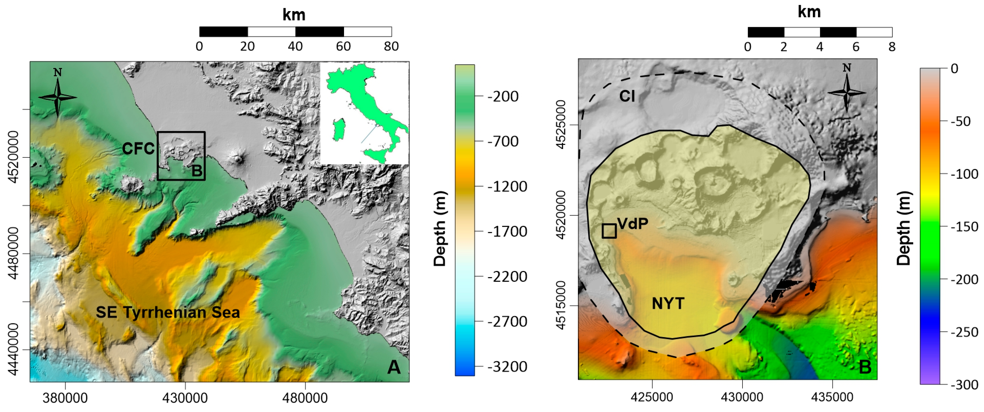
Figure 2.
Morphology of Villa dei Pisoni. A) Shaded relief map; B) Contour map.
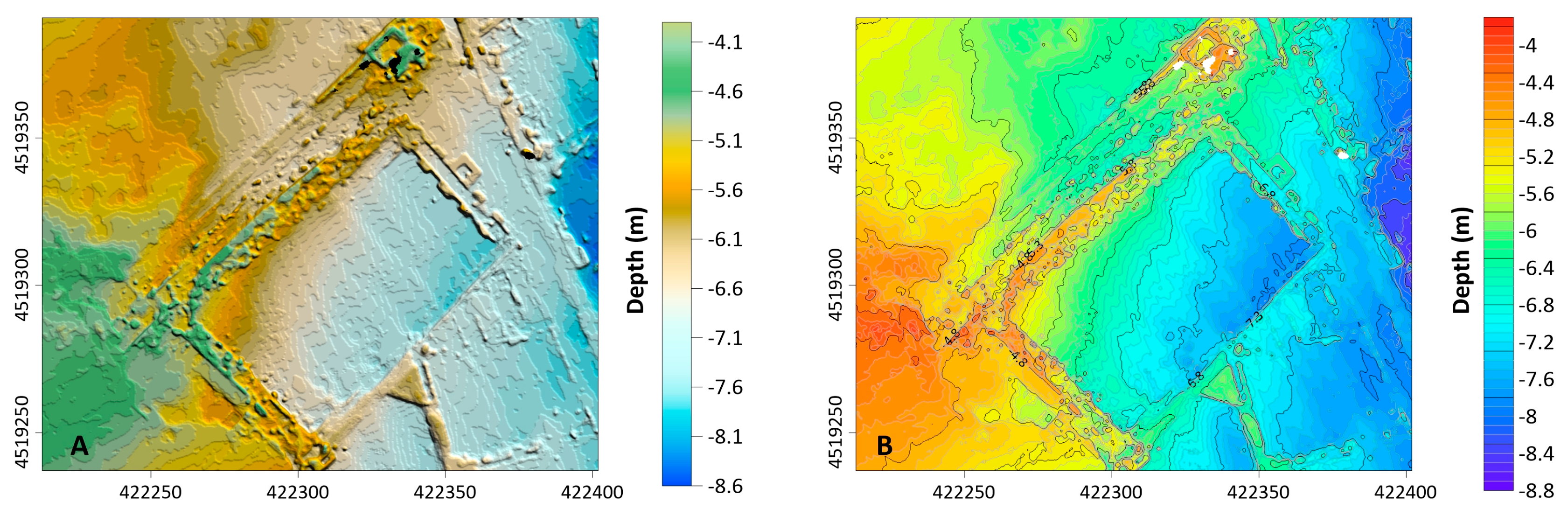
Figure 3.
Location map of sapling stations.
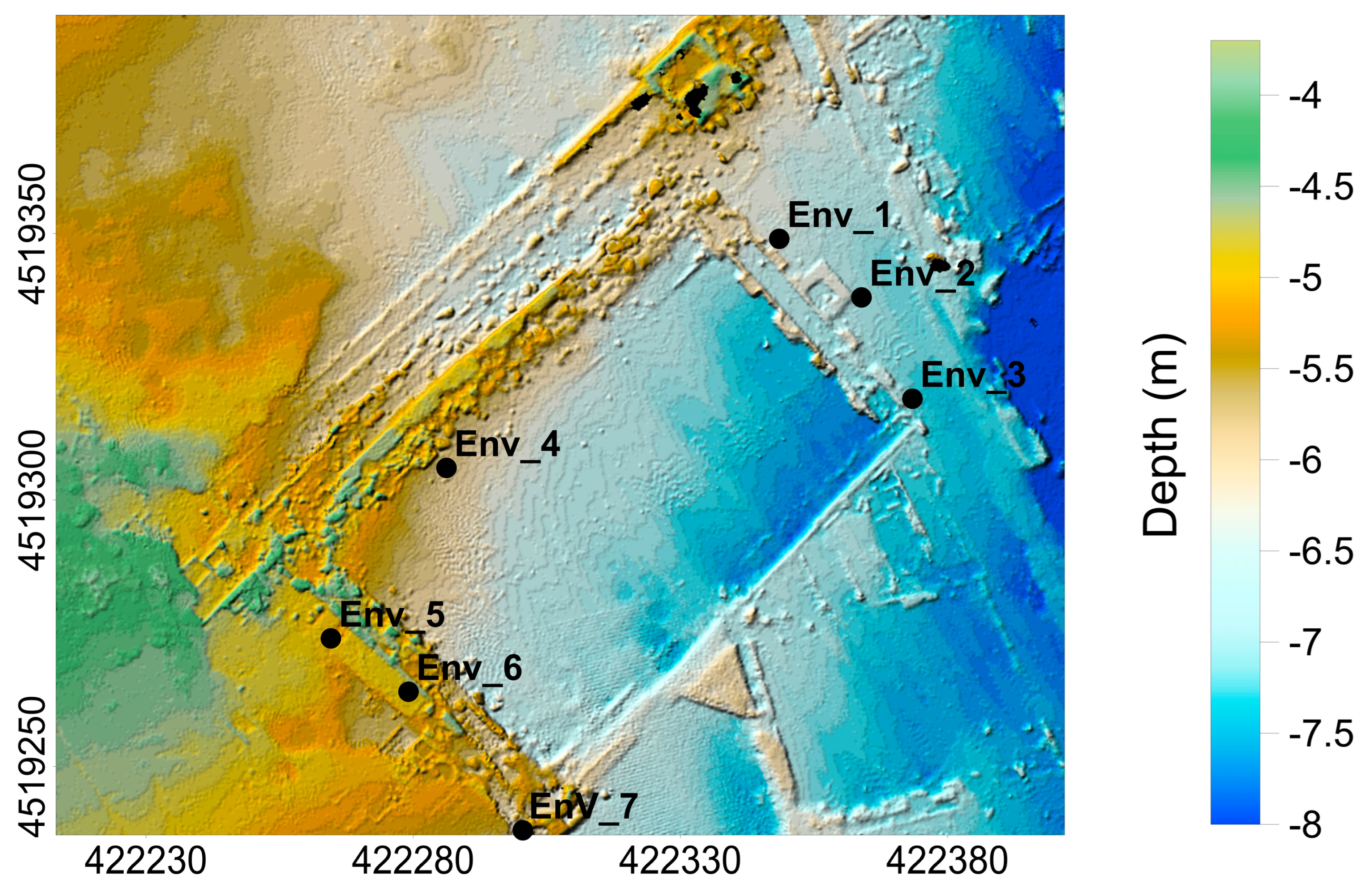
Figure 4.
Triangular diagram showing the results of sedimentologic analysis.
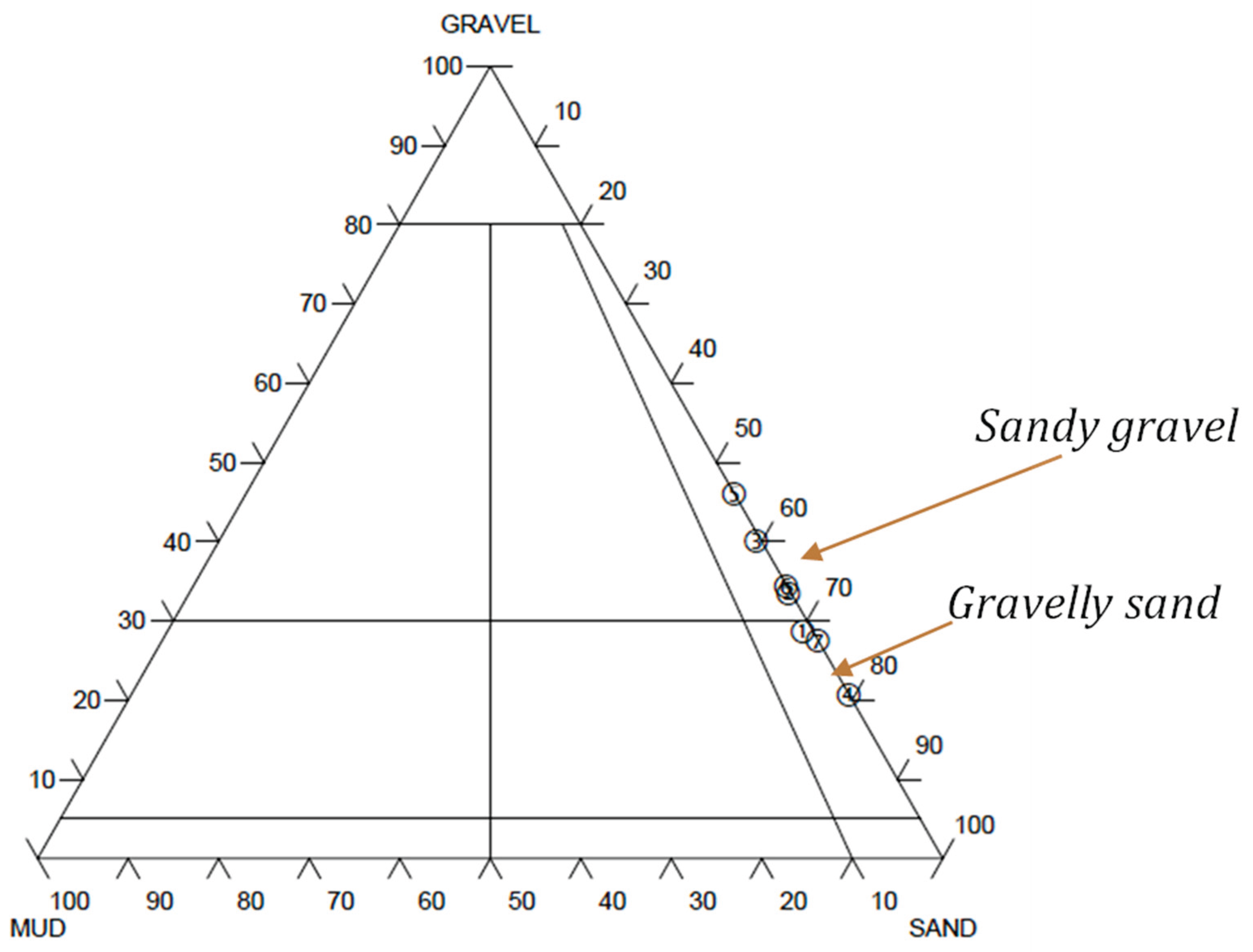
Table 1.
Textural parameters of surface sediments at the Villa dei Pisoni site.
| Station ID | Gravel (%) | Sand (%) | Silt (%) | Clay (%) | Classification |
|---|---|---|---|---|---|
| Env_1 | 28.59 | 70.21 | 1.19 | 0.00 | Gravelly Sand |
| Env_2 | 33.40 | 66.22 | 0.37 | 0.00 | Gravelly Sand |
| Env_3 | 40.06 | 59.33 | 0.57 | 0.04 | Gravelly Sand |
| Env_4 | 27.46 | 72.47 | 0.07 | 0.00 | Gravelly Sand |
| Env_5 | 20.53 | 79.37 | 0.10 | 0.00 | Gravelly Sand |
| Env_6 | 46.00 | 53.95 | 0.05 | 0.00 | Gravelly Sand |
| Env_7 | 34.30 | 65.57 | 0.13 | 0.00 | Gravelly Sand |
Table 2.
Organic pollutant concentrations in surface sediments (μg /kg dry weight).
| Parameter | Env_1 | Env_2 | Env_3 | Env_4 | Env_5 | Env_6 | Env_7 | |
| PAHs sum (μg/kg dry weight) | 504 | 229 | 3904 | 34.3 | 8.08 | 85.9 | 378 | |
| PCBs sum (μg/kg dry weight) | 1.26 | 0.548 | 1.51 | <LOQ | 0.40 | 0.39 | 0.68 | |
| OCPs sum (μg/kg dry weight) | <LOQ | <LOQ | <LOQ | <LOQ | <LOQ | <LOQ | <LOQ | |
| VOC (μg/kg dry weight) | 3026 | <LOQ | 5022 | <LOQ | <LOQ | <LOQ | <LOQ |
Table 3.
Major and trace element concentrations in sediments.
| Element | Unit | Env_1 | Env_2 | Env_3 | Env_4 | Env_5 | Env_6 | Env_7 |
| K | mg /kg | 21 | 25 | 22 | 26 | 23 | 22 | 16 |
| Ca | g/kg | 284 | 134 | 168 | 111 | 93 | 134 | 243 |
| Fe | g/kg | 24 | 28 | 22 | 28 | 30 | 25 | 21 |
| Ti | mg/kg | 1022 | 1321 | 1120 | 1281 | 1300 | 1110 | 908 |
| V | mg/kg | 45 | 291 | 266 | 62 | 46 | 54 | 194 |
| Cr | mg/kg | 25 | 27 | 25 | 28 | 422 | 30 | 21 |
| Mn | mg/kg | 745 | 570 | 541 | 731 | 648 | 671 | 584 |
| Ni | mg/kg | 18 | 26 | 24 | 25 | 74 | 20 | 19 |
| Cu | mg/kg | <LOQ | 11 | 15 | 9 | 10 | 11 | <LOQ |
| Zn | mg/kg | 75 | 82 | 64 | 75 | 74 | 74 | 85 |
| As | mg/kg | 189 | 162 | 127 | 189 | 190 | 196 | 115 |
| Rb | mg/kg | 572 | 170 | 157 | 180 | 1540 | 764 | 690 |
| Sr | mg/kg | 1501 | 1260 | 1071 | 862 | 833 | 779 | 1420 |
| Zr | mg/kg | 269 | 270 | 253 | 283 | 232 | 273 | 247 |
| Pb | mg/kg | 62 | 72 | 54 | 52 | 57 | 62 | 52 |
| Th | mg/kg | 35 | 37 | 31 | 34 | 34 | 34 | 31 |
Disclaimer/Publisher’s Note: The statements, opinions and data contained in all publications are solely those of the individual author(s) and contributor(s) and not of MDPI and/or the editor(s). MDPI and/or the editor(s) disclaim responsibility for any injury to people or property resulting from any ideas, methods, instructions or products referred to in the content. |
© 2026 by the authors. Licensee MDPI, Basel, Switzerland. This article is an open access article distributed under the terms and conditions of the Creative Commons Attribution (CC BY) license (http://creativecommons.org/licenses/by/4.0/).
Copyright: This open access article is published under a Creative Commons CC BY 4.0 license, which permit the free download, distribution, and reuse, provided that the author and preprint are cited in any reuse.