
Submitted:
05 October 2026
Posted:
08 October 2026
You are already at the latest version
Abstract
Most traces of past impacts with cosmic bodies that occurred on Earth during Time have been erased by geological processes, such as subduction and erosion, have been hidden by sedimentation and volcanism, or have been covered by seawater; the Moon, the Earth’s natural satellite, may be considered our best scientific laboratory for impact cratering processes. The number of accepted and recorded impact craters on Earth suddenly increased when observations have been taken from the above the Earth from airplanes, satellites and drones. The number of accepted and recorded old impacts on Earth recently started to increase when scientists turned toward the deeply located buried craters, using Geophysics. The available recorded impacts have been completed with re-cently published large diameter of buried impact structures: Precaspian Depression, situated in Kazakhstan and Russia (ca 700 km), Alexandria Depression, situated in Romania and Bulgaria (ca 175 km) and Transylvanian Depression, situated in Romania (ca 300 km). The recorded impacts suggest that a correlation with life extinction events can be made in Devonian (Fras-nian-Famennian) and at the Cretaceous-Tertiary boundary, Chicxulub event being known world-wide. It is likely that large diameter impactors on Earth might represent a necessary condi-tion for relating impacts with cosmic bodies to high extinction events. Large diameter asteroids, interpreted to have created the Precaspian and Alexandria depressions during the Permian may be well correlated with the Maokouan (50% life extinction) and Changhsingian (78% life extinction). On the three discussed study cases, the Bouguer gravity anomaly was the main geophysical in-formation for detecting a buried impact structure; besides the traditional gravity low, high gravity anomalies associated with the uplifted Crater rim and Central peak are being interpreted. The magnetic anomalies of the Precaspian region illustrate a circular sector with high magnetic anom-alies, interpreted as effects of the uplifted magnetic basement along the Crater rim and partly, effect of the magnetic “step effect” above abruptly ended magnetic geological formations. The magnetic anomalies over the Alexandria Depression proved to be weak and less associated to the impact structure; the crater uplifted sectors have been probably eroded and its infrastructure masked by the effect of thick lava flows, embedded in the depression sedimentary infill. The magnetic data of the Transylvanian Depression contradicts the usual way magnetic anomalies are interpreted above impact structures, a large and intense high magnetic anomaly being measured, instead of a large magnetic low. This anomaly, aided by a magnetic 2D modeling, was interpreted as effect of a huge magmatic structure, a batholith, intruded suite of geological processes determined by the asteroid impact.
Keywords:
impact craters
; life extinction events
; magnetic anomalies
; buried impact structures
; Precaspian
; Alexandria
; Transylvanian depressions
1. Introduction
We may imagine that interactions and collisions at various scales occurred since the time when protoplanets, which were going to form the Solar System, started to aggregate and increase in volume. This increase in diameter of cosmic bodies determined a raise in the collision probability due to their enhanced attractive gravitational field and this way, became a growing target for neighboring planetesimals.
When thinking at the early ages of planet Earth, two main stages might be envisaged:
The Hot Earth, having outer surface and inner parts preserving the original physical state of viscous hot magma. Earth, as a newly aggregated cosmic body, kept rotating as part of the system of planets around the local star, the Sun.
For the Hot stage of the Earth, when considering the objectives of this article, it is wise to eliminate from our personal thinking all collisions that have created short time impact craters, formed in a wholly viscous framework. Some of these early impacts may have left distinct mineralogical traces within our planet inner parts, still remained to be geologically discovered and properly interpreted on cores collected in deep boreholes or geophysical anomalies.
There are not yet recorded impact craters or any trace of impact cratering from that time of the Hot Earth, the viscous state of the crust being not able to preserve such particular scars on the planet surface from remote times.
The Cold Earth, having cold crustal and lithospheric planet’s marginal sectors, in a physical solid state. Obviously, Cold Earth is just a way of comparing with Hot Earth, a completely hot planet from its outer surface till the inner core. The Earth as we know it today, enveloped by a consolidated outer shell of rigid rocky structures till the asthenosphere, could be better called the “outer Cold Earth”.
Once the Earth crust has formed, passing from a hot molten viscous lava state to a cold solid and rigid one, the minerals gathered upon their geochemical affinities and formed rocks, and finally, rocks formed the primitive geological structures and the first continents. From then on, all impacts of Earth with wandering celestial bodies have been carved on the topography of each solid outer surface, offered by our planet during the Geological time.
Unfortunately, most traces of past impacts with cosmic bodies that occurred on Earth during Time have been erased by geological processes, such as subduction and erosion, have been hidden by sedimentation and volcanism, or have been covered by seawater [1].
The Moon, the Earth’s natural satellite, may be considered our best scientific laboratory for impact cratering. It started to be scientifically studied soon after Galileo Galilei (1564-1642), an Italian famous astronomer, built a telescope and used it as early as 1609 to look toward the Moon. Galilei used his instrument for observing circular structures of various size on the Moon’s surface. After its personal analysis and interpretation, Galilei decided that these structures are not mountains, as was his first impression, but large depressions on the Moon’s topography, some of them having central peaks.
Several centuries after Galileo Galilei, astronomers and geologists considered the large circular structures on the Moon’s surface as being formed by volcanic processes, since they were looking so similar to the well-known volcanoes on Earth. At that time scientists have not yet knowledge on the existence of wondering cosmic bodies outside and inside the Solar system, such as meteorites and asteroids, and hence could not link to them the existence of craters on the Moon.
Later, the German scientist Alfred Wegener (1880-1930), considered that such structures on the Moon and the Earth’s surfaces are the result of impacts with celestial bodies.
Long time during the XX-th century the main part of astronomers and geologists remained attached to the volcanic origin, ignoring Wegener’s correct interpretation, as it was also the case when he explained the Earth’s continents drift.
The best evidence to all kind of scientists that the impact cratering was caused on the Moon, on the Earth and other similar planets, by collisions with cosmic bodies, was the discovery of the Meteorite Crater in Arizona, USA, a quite recent structure, well preserved, of Quaternary age [2]. Since geologists have discovered, during the XX-th century, rounded craters on continents which could not be clearly related to volcanic processes, the close association between these terrestrial scars with the Moon depressionary circular structures and impacts with wondering cosmic bodies, such as meteorites, asteroids and cometary cores, was finally done by specialists in Astronomy and Earth Sciences [3].
When Geology accepted significant changes from the “stable” evolutive concept, of only gradual changes during geological processes, to catastrophic changes due to sudden and short living phenomena, numerous scientific studies, many times aided by borehole information or geophysical surveys, re-interpreted geological structures as being due to impacts with extraterrestrial bodies.
2. Impact Cratering on Earth During Geological Time
Impact cratering on Earth caused by collisions with wandering celestial bodies has become, during the second half of XX-th century, a distinct part of Space Science, distinguished scientists, mostly coming from Astronomy, Physics and Earth Sciences, working in this field with high interest and dedication. Things changed so rapidly in this new domain, so that at the beginning of XXI-rst century, new branches of Earth Sciences are being dedicated to Impact Geology or Impact Stratigraphy. Numerous other persons, having it as a hobby or just as an interface with unknown and mysterious aspects of the Universe, contributed with field observations, write books and scientific articles or attending dedicated conferences, participating this way to the development of the Impact Cratering domain. The number of accepted and recorded impact craters on Earth suddenly increased when observations have been taken from the above the Earth, at different heights, from airplanes, satellites and recently, using drones.
There is a vivid and dynamic evolution considering the development in real time of observed, investigated, accepted and recorded new impacted sites, professional associations and scientific centers being already established. The Earth Impact Database records the number of impacts, the craters dimensions and their geological age. As recent geological, geophysical and borehole observations showed, an increasing number of impacted structures are presently found in the marine settings [4].
Recently, buried impact craters beneath thick piles of sedimentary and volcanic geological formations have been interpreted based on the interpretation of geophysical and geological information provided by exploration surveys for mineral resources [5,6,7].
A valuable review of impacts on Earth during Geological time we consider to be the chart presented by G. Keller [8], which illustrates important interpreted facts as recorded impacts assigned with geological time, all correlated with intensity of extinction events. The number of impacts and their geological age are based on data provided by Earth Impact Database [9].
The chart presented by G. Keller [8] has been completed with existing diameter information related to the largest impact craters partly mapped on the Earth’s surface: Sudbury, Canada (ca 250 km) and Vredefort, South Africa (ca 300 km). It has even more completed with large impact craters recently interpreted on regional exploration geophysical and geological data: Precaspian Depression, situated in Kazakhstan and Russia (ca 700 km diameter [5]), Alexandria Depression, situated in Romania and Bulgaria (ca 175 km diameter [6]) and Transylvanian Depression, situated in Romania (ca 300 km diameter [7]).
Considering the geological age of the recorded craters, for the Proterozoic geological time (1000-540 M.y. ago) the chart illustrates fourteen recorded impacted sites, having diameters ranging between 5 and 25 km, and two craters ranging between 50 and 100 km, in the vicinity of Proterozoic-Palaeozoic boundary [8]. We may add for the chart presented in Figure 1 Precambrian ages for Sudbury and Vredefort impact structures, Lower Permian for Precaspian, Upper Permian for Alexandria and Badenian (Lower Neogene) for Transylvanian impact structures.
Coming back to the data presented by G. Keller [8], during the Lower Palaeozoic, in the Cambrian and the Ordovician (540-443 M.y.), twelve impacts ranging between 5 and 25 km diameters have been included in the database, a thirteen one being larger, situated in the 25-50 km diameter range. After a pause that can be noticed during the Silurian (443-416 M.y.), with only one small impact crater recorded, an intense celestial bombardment seemed to have followed during the Devonian and the Carboniferous (416-300 M.y.), with nineteen recorded impacted sites. What is special for that geological time, two impact craters have diameters between 51 and 100 km and two other sites are ranging between 100 and 150 km, suggesting that also asteroids were among the fallen cosmic bodies. In the Upper Palaeozoic, during the Permian (300-250 M.y.), five impacts were recorded in the database, three with diameters between 5 and 25 km and two with diameters between 25 and 50 km diameter. We may add here the recent interpreted large impact craters in the Precaspian (ca 700 km) and Alexandria (ca 175 km), shown in Figure 1.
During the Mesozoic, the Triassic and Jurassic (250-145 M.y.) are characterized by seven low diameter craters (5-25 km) and two larger diameter ones, situated between 50 and 100 km. The situation seemed to change during the Cretaceous (145-65 M.y.), with numerous recorded impacts: sixteen with low diameter craters (5-25 km), four impacts with larger crater diameters, between 26 and 50 km and three impacts with large ones (51-100 km). Very important is the Chicxulub impact crater, produced at the limit between the Cretaceous and the Tertiary, at ca 65 M.y., its diameter being estimated to be situated between 151-200 km.
Tertiary geological time offers the largest number of recorded impact craters on the Earth’s surface, probably related to a better preservation of geomorphological characteristics of impacted sites, caused by lower time for active erosional processes or burial due to sedimentation and/or volcanism. Twenty-two craters with small diameters (5-25 km), two larger ones (26-50 km) and three large impacted sites, situated in the 51-100 km range. In this geological time we may add the Transylvanian impact crater, recently interpreted on geophysical and geological data, as having ca 300 km diameter.
Of great interest are the geological age of major life extinction events [8], most important being here considered those determining at least 40% extinct species (Figure 2): Middle Cambrian (44%), Upper Cambrian (42%), Ashgillian (Upper Ordovician – 60%), Upper Devonian (Frasnian-Famennian 58%), Maokouan (Upper Permian – 50%), Chanhsingian (Permian-Triasic, 78%) and Maastrichtian (Cretaceous-Tertiary, 47%).
There is no general agreement among scientists that life extinction events on Earth, as noticed for quite a long time by Paleontology, can be clearly correlated with cosmic bodies impacts, in the cause and effect sense. The chart prepared by G. Keller [8], including recorded impacts and observed life extinction events suggests that connections can be made along geological time between these two natural phenomena. Analyzing in this respect Figure 1 and Figure 2, of great interest are the life extinction events in Devonian (Frasnian-Famennian) and at the Cretaceous-Tertiary boundary, due to overlapping with large diameter impacts, Chicxulub being the best known world-wide. It is likely that large diameter impactors on Earth might represent a necessary condition for relating impacts with cosmic bodies to high extinction events. If so, the large diameter asteroids, interpreted to have created the Precaspian (ca 700 km diameter) and Alexandria (ca 175 km diameter) depressions during the Permian may be well correlated with the Maokouan (50%) and Changhsingian (78%) high intensity extinction events, lacking so far of recorded impacts. If this interpretation is correct, several buried large diameter craters might be discovered in the next future, considering the Changhsingian, highest intensity of extinction event, which may have not be totally determined by the Alexandria impact. We consider that one, or several large buried craters, might be located on the future using integrated geophysical and geological data to be correlate with the Ashgillian extinction event (Uppermost Ordovician), lacking presently of recorded large diameter craters.
3. Geophysical Mapping of Buried Impact Craters on Earth
Traces of impact craters are studied for quite long by astronomers in the Solar system planets and their satellites. Besides the already recorded impact craters on Earth, in sites situated on continents surface or at the sea bottom level, unknown and deeply located large impact craters within the Earth are to be nowadays investigated by means of Geophysics.
Geophysical methods, relevant for more than one century in exploring deeply situated geological structures, are Gravimetry and Magnetometry, when large areas are to be covered with measurements aiming at building geophysical maps. Refraction and Reflection Seismics, as well as Magneto-telluric soundings, are mostly carried out on selected transects, where investigations on the survey lines provide information on the geometry and depth of buried geological structures. As it may be observed, one of the main geophysical methods, usually employed in geological exploration for mineral resources, is the Magnetic method.
The Magnetic method is used by geophysicists for more than one century, the iron ore deposits, bearing large concentrations of magnetite, being during its pioneering times, the main targets. The accuracy of magnetometers, instruments developed to usually map the variability of the magnetic field and its vertical component, increased during the XX-th century, so this fast and cheap method became a Must in all types of regional reconnaissance and mineral resources exploration, either terrestrial or airborne. The magnetic method became more recently a Must in environmental, archaeological, UXO and even in forensic studies.
Started as a terrestrial geophysical method, the magnetic method covered with useful information the marine domain and the aerial one, as airborne magnetics/aeromagnetism, satellite magnetics and presently, with high accuracy at low altitude measurements, using drones.
Most of the existing terrestrial, airborne and satellite magnetic maps may be presently analyzed and re-interpreted when looking for buried traces of impact craters on Earth.
There are several important problems in doing so:
- the magnetic maps to be already published or available from governmental agencies and private companies;
- the magnetic properties of rocks in the studied area to be published in books or scientific articles;
- the scientists who analyze and interpret such magnetic data should have expertise in the geophysical exploration of deep geological structures, based on a proper understanding of physical properties of minerals, rocks and geological formations.
3.1. Magnetic Properties of Minerals and Rocks
Dedicated studies on the magnetic properties of minerals and rocks started to be carried out more than one century ago, when Physics has been invited to help Geology searching for buried mineral resources, through the newly created field of geosciences, Exploration Geophysics. This part of Geophysics has been involved from its beginning in finding deeply located mineral resources, such as oil, gas and metals accumulations.
The Magnetic method, one of the main geophysical domains acting in Exploration Geophysics, was involved from its early moments in locating iron ore deposits, magnetite being the leader pathfinder for discovering iron deposits. Later on, enlarging the method capabilities based on the magnetite content of rocks, it has been used to discover other types of ores deposits, such as Cu, Au and Mo in porphyry copper deposits.
Aiming at extending the applicability of the Magnetic method to detect other types of mineral resources bearing magnetic minerals in their mineral assemblages, and to better understand their host geological structures, the magnetic properties of minerals and rocks have been compiled from geophysical technical reports, published scientific articles or textbooks (e.g., [10]). The usual way of presenting information on the rocks and geological formations magnetic properties has been as book chapters in volumes dedicated to Geophysical Exploration methods, enabling geological interpretations of ground and/or airborne magnetic measurements as case histories (e.g., [11,12,13,14,15]). Books presenting ways for a quantitative interpretation of geophysical anomalies, including the magnetic ones, and building in most cases 2D or 3D geological models, have been published especially during the 1960’ (e.g., [16]). The mentioned volume described magnetic properties across the Sudbury complex magmatic structure, rich in Cu-Ni mineral resources, long before it being considered as a Precambrian impact crater.
Minerals and rocks magnetic properties have been generally described quantitatively using the Magnetic Susceptibility (MS), a petrophysical quantity showing the possibility of rocks minerals for getting magnetized under the influence of the Earth magnetic field. Until the 1970’ the magnetic susceptibility has been measured in the CGS system; most published data utilized to understand the magnetic properties contrasts in rocks and geological formations are dating from that time. During the past 4-5 decades the magnetic susceptibility of minerals and rocks has been measured in the SI system, the information on the magnetic properties of rocks utilized in magnetic anomalies interpretation being published in SI units.
Minerals and rocks may preserve a Natural Remanent Magnetization (NRM), acquired under the influence of past Earth’s geomagnetic fields. It happened usually during significant events of their evolution during geological time, such as regional metamorphism or magmatic processes. There is rather difficult to get information on rocks natural remanent magnetization, necessary for a correct geological interpretation of the magnetic anomalies, since it is measured in specialized laboratories on samples collected using a special technique. When rocks are characterized by both induced and remanent magnetization, their magnetic properties are considerable enhanced.
During the 1930’ attempts have been made to use the Magnetic method as a tool for the geophysical exploration of buried geological structures and deeply located mineral resources. Magnetic susceptibility measurements barely existed at that time, the magnetic properties of rocks being calculated based on the specific rocks content in magnetite [11]. Comparing such MS values with what has been later measured on rocks samples and outcrops, they look too big nowadays, showing that both mineralogical analyses on the magnetite content and the mathematical formulas were not sufficiently accurate at that time.
Between the 1950’ and 1970’ a large number of geophysical explorations results, represented by ground and airborne magnetic maps, required a good understanding of magnetic properties of rocks, when searching for buried geological structures bearing metals or oil accumulations. Numerous scientific articles and textbooks published datasets with information on the variability of the magnetic susceptibility have been measured on rocks using the CGS system. A few examples, selected from one of the most popular books written for exploration geophysicists [14], are presented in Table 1.
3.2. Changes of Rocks Magnetism During and After Impacts
Shock metamorphism and shock re-magnetization should be the main terms when discussing modifications in the magnetic properties of the impacted rocks. Numerous studies have been carried out on rocks and remnants of impact crater structures, gaining knowledge on present day mineralogical and petromagnetic features of past impacted areas. All knowledge on the mineralogy changes during impact and immediately after that event, as well as on magnetic property modifications, are still based on scientific hypotheses and various kinds of modelling.
Shock magnetism may be defined as an alteration of the intensity and direction of rocks magnetization caused by dynamic and thermochemical effects due to impacts of Earth with cosmic bodies. It may take place during the impact or last over long geological time due to residual temperature effects. The changes in induced and remanent magnetization depends on the impactor mass and velocity, and on the mineralogical composition of impacted area. The impacted geological structures will experience magnetization changes due to variability of magnetic parameters with temperature, pressure and time, and modifications in the targeted site, such as advanced fracturing and faulting. A significant modification of minerals magnetic behavior after being impacted, is that the paramagnetic iron-bearing silicates become ferromagnetic after shock heating processes [17].
High remanent magnetization acquired by rocks in impacted areas may be the cause of important terrestrial or airborne magnetic anomalies. A good example is the Vredefort impacted structure, located in South Africa and dated at ca 2.0 billion years, where the high intensity magnetic anomaly was attributed to the important magnetic remanence of Archaean granites. Usually, granites do not bear magnetite, but in this particular case, magnetite, the mineral characterized here by high magnetic remanence, have been intruded along deformation features in quartz minerals after the impact [18].
Reverse thermal remanent magnetization of suevites, a 100 m thick layer of post-impact breccia covering the bottom of the crater sedimentary filling, is interpreted to be the source of the aeromagnetic anomaly surveyed over the Riess impacted area (Germany).
In the case of meteorites with provenance from the inner core of broken planets, the high content of iron would determine, theoretically, an increase of the magnetic properties of the impacted area. However, as it was the case with the Meteorite Crater (Arizona, USA), the best known and preserved impact crater on Earth due to its “young” geological age (Quaternary), hopes of mining the iron brought by the cosmic body on Earth vanished quite soon, leading the optimistic company into bankruptcy.
Considering the detection of buried impact craters beneath sedimentary or volcanic geological formations by interpreting magnetic anomalies, as it is discussed in this article, it must be noticed that direct measurements of MS or NRM on outcrops or in laboratory are not possible in such cases, since rocks samples from that great depths are not available.
4. Study Cases: Precaspiam, Alexandria and Transylvanian Depressions
Geophysical investigations of impact structures on Earth have been mainly discussed during the 1990’, soon after impact cratering became an important topic in scientific conferences and publications. It was accepted that low gravity anomalies are the most suitable signatures for impact craters, followed by the low magnetic ones, the latter being more complicated due to the high variability of magnetic properties in minerals and rocks [19]. To overcome this difficulty, borehole drill cores have been proposed to be measured for magnetic properties. The low magnetic anomalies observed as crater background and the short wavelength high magnetic anomalies mapped on impact structures were considered less understood a few decades ago. However, since these structures are including breccias, hydrothermally altered formations, shocked crystalline and melt rocks besides the crater sedimentary infill, all formations with low magnetic properties, the magnetic low becomes sufficiently explainable [20].
The magnetic detection of deeply located impact craters should be based on the following interpretation criteria:
- The post-impact breccias and conglomerates, the hydrothermal altered rocks due to post-impact geothermal systems, and the sedimentary formations filling the crater area represent geological sources for a low magnetic anomaly signature [21];
- In certain situations, high magnetic anomalies may by mapped above the buried Crater rim, where uplifted basement metamorphic rocks include paramagnetic and ferromagnetic minerals. In such situations the magnetic maps may display a circular to ellipsoidal high magnetic anomaly above the buried impact area [5];
- Due to the high depths where the buried impact craters are presently located, and the upward distance to the airborne instruments, clear magnetic effects of suevites and layers with melt rocks on the aeromagnetic anomalies are not to be expected;
- Impact and post-impact determined extrusive, effusive and intrusive magmatic processes, resulting in significant volumes of magmatic products beneath and above the impact area are to be carefully observed and properly interpreted, since they may represent valuable indirect evidence of past impact cratering processes;
- In cases of impacts with large asteroids, piercing the entire crust and possibly the whole lithosphere, low magnetic anomalies may be observed on maps built on satellite observations.
In the impact cratering literature, there are two important structural components of the impacted area [24]:
- the Basin, representing the largest area having effects on the impacted geological formations;
- the Depression, representing the deepest sector where presumably the impactor hit the Earth’s surface.
In order to do not create confusion by using the term Basin, differently utilized in the geological literature, we shall refer in the following study cases as Depression.
4.1. The Precaspian Depression
The Precaspian Basin is situated north of the Caspian Sea, between the Caucasus Mts. and Ural Mts. It is a large sedimentary basin, has a W-E elongated shape (600 x 900 km), and is located in Russia and Kazakhstan, at the south-eastern margin of the East European Platform. The basin is filled with more than 20 km of sediments in its Central Precaspian Depression.
The sedimentary succession includes two main stages, separated by the 4 km thick saliferous series of Lower Permian age. Upper Palaeozoic sedimentary formations have been drilled in the basin marginal zones; Upper Permian–Triassic red beds have been sedimented above the saliferous series, followed by carbonate and terrigenous sediments from Jurassic to Present. The presence of several km thick layer of salt introduced a complicated problem in the basin subsidence modelling [25]. The Precaspian Depression is considered to originate in rifting processes and subsequent emplacement of oceanic lithosphere. Its subsidence and thick sedimentary fill have been tentatively explained by downward pull of heavy eclogite lenses developed at the base of the crust. However, there is not a model on the formation and evolution of the Precaspian Basin that can explain all the features of its structure [26].
Based on the Bouguer gravity anomalies map [27], which shows around the Precaspian Basin a large ellipsoidal sector with high gravity anomalies, we interpreted it as the effect of uplifted Crater rim; in the central basin part the high gravity anomaly was interpreted as effect of uplifted Central peak. Considering these re-interpretations of the Bouguer gravity map, this large and deep sedimentary structure was interpreted to be caused by impact with an asteroid ([5,28]). That is why in the following we shall refer to the Precaspian Depression instead of Precaspian Basin.
The Total magnetic field anomalies map compiled by [29] was considered suitable to be interpreted for detecting buried geological structures of the Precaspian Depression. This regional magnetic map has been processed in order to refer to the same magnetic epoch at the same observation altitude (3,000m); the resulted magnetic anomalies represent residuals after substracting the reference geomagnetic field DGRF1980.
The total field magnetic anomalies, presented in Figure 3, illustrate elongated, circular high magnetic anomalies, crossing the northern part of the Caspian Sea and developing toward NNE and NNW. The high magnetic anomalies encircle an area similar in shape and surface to the Precaspian Basin, the same area encircled by high Bouguer gravity ones.
The geological interpretation of the high magnetic anomalies situated around the Precaspian Depression is related to their association with uplifted crystalline basement structures, meaning with the Crater rim, at the depression margins. The active magnetic metamorphic rocks are in magnetic properties contrast with the paramagnetic sediments and the diamagnetic salt layer, the latter characterized by low or even negative magnetic susceptibility. It is likely that a part of the high magnetic anomalies located around the Precaspian Depression are determined by the magnetic “step effect” [16], the basement metamorphic structures ending abruptly on the crater edge.
Satellite magnetic anomalies, as those observed by the MagSat mission, contoured an intense ellipsoidal in shape magnetic low [30], that overlaps the Precaspian Depression. When analyzing the satellite magnetic anomalies mapped on Earth during the MagSat mission, intense low magnetic anomalies have been located in the Caspian Sea region. The ellipsoidal magnetic anomaly, situated north of the Caspian Sea, represents the magnetic effect of low magnetic properties of thick sediments and salt layers in the Precaspian Depression. Southward, the elongated intense low magnetic anomaly is here interpreted to be mainly associated with the superdeep South Caspian Depression, filled with more than 25 km of sediments [31], also characterized by low magnetic properties.
The Precaspian Depression has been nicely described by regional crustal refraction seismic experiments during the 1960’ and 1970’. The refraction data interpretation showed here a ca 22 km deep depression, having a 2 km uplifted central zone [32].
A refraction seismic section crossing the depression, recently published by [26], was redrawn in this article aiming at illustrating our impact crater hypothesis. The impactor penetrated in the Precaspian area the entire granitic crustal layer, creating a 22 km deep depression, somehow similar to the impact interpreted for the largest and deepest Aitken crater, attentively investigated on the Moon [33,34].
The magnetic “step effect”, determining magnetic highs on edges of magnetic geological formations, may be nicely observed in Figure 4, at the abrupt contacts between the basement with the sedimentary cover. The uplifted basement crystalline rocks beneath the Crater rim are not evidenced by the seismic refracton section, but their magnetic effect may represent a major component in the magnetic highs illustrated on the geophysical profile.
Magnetic anomalies related to magmatic structures, determined by the postulated Precaspian impact, were not identified in the depression area, possibly due to the high depths where they might be situated.
4.2. The Alexandria Depression
The Alexandria Basin is a large buried geological structure consisting in sedimentary and magmatic formations, located in the Moesian Platform in Romania and Bulgaria, between the Carpathian and Balkan mountain ranges. The area is a flat field whose altitudes are decreasing towards the Danube.
In the western part of the Moesian Platform, in close vicinity with the Alexandria Depression, boreloles pierced crystalline basement rocks consisting of epimetamorphic clorite schsists located below Palaeozoic sedimentary formations: Ordovician, Silurian, Carboniferous and Permian. A few boreholes reached granitic and gabbroic magmatic bodies, emplaced in metamorphic shists. The igneous rocks, considered to be of Permian age, are considered to represent intra-plate magmatic products rather than subduction related structures [35,36].
Eruptive magmatic formations have been described in boreholes in this region as lava flows, sometimes overlapped. Their eruption started in the Lowermost Triassic during successive stages, probably along deep fractures. The first and the third stage have been characterized by acid magmatic products, while the second stage, by basic magmatic products [35]. The volcanic rocks are represented mostly by rhyolites (red porphyres) and less by basic rocks; they have thicknesses in boreholes ranging between 600 m and 1000 m.
Characteristic for the region where the Alexandria Depression is situated are acidic and basic lava flows that took place during the Upper Permian and the Lower Triassic. The lavas developed in taphrogenic structures trending E-W, while those occurred during Middle Triassic and Upper Triassic are usually trending N-S.
The intrusive magmatism, probably emplaced during the Triassic, is situated west and north of the Alexandria Depression. The N-S trending intrusive structures located west of the Alexandria Depression are situated in the Craiova-Bals uplifted zone; they consist mainly of basic rocks, such as gabbro and diorites, associated with granodiorites and quartz diorites. The E-W trending intrusives located north of the Alexandria Depression are situated in the Slatina-Mogosesti area; they consist of granitic rocks, possibly emplaced during the Lower Palaeozoic [36].
The Alexandria Depression has been geophysically investigated especially using Bouguer gravity and seismic surveys, the latter employing either refraction or reflection techniques. The integrated interpretation of geophysical gravity and seismic data resulted in a 10 km for the depression deepest sector.
The vertical component of the magnetic field anomalies on the Romanian territory have been compiled and published during the early ‘80 [37].
Recently, the Alexandria Depression has been interpreted as an impact structure [6], its buried crater being probably created by an asteroid during the Uppermost Permian, at the limit with Triassic geological time.
In the area of the Alexandria Depression low magnetic variations are illustrated in Figure 5 in the vertical component anomaly magnetic map, in good agreement with the presence of a thick pile of paramagnetic sedimentary formations and diamagnetic salt sequences. A small increase in the magnetic level, ranging from 0 and 50 nT is to be observed above the depression, in close connection with the interbedded thick rhyolitic lavas, most of them characterized by low magnetic properties.
In the northern and northwestern vicinity of the Alexandria Deprdession, the W-E elongated high magnetic anomaly is associated with thick basic magmatic lava flows, mostly interbedded in Lower to Middle Triassic sediments [36].
The most intense magnetic anomalies, located west of the depression are mostly determined by basic to intermediate magmatic intrusions of Permian age, their emplacement being possibly associated with the impact event.
In the Alexandria Depression study case, the magnetic anomalies do not detect the depression created by the impact happened during the Upper Permian. However, the magnetic data are able to illustrate the presence of effusive and intrusive magmatic products in geological structures, possibly determined by the cosmic impact during the Upper Permian times.
4.3. The Transylvanian Depression
The Transylvanian Depression is situated in the northwestern part of Romania, being surrounded by the East Carpathians, the South Carpathians and the Apuseni Mountains.
Transylvanian Depression is geologically considered as the largest post-tectonic Neogene depression situated on the Romanian territory. The depression started to be built at the end of the Lower Miocene time, the entire area being characterized by deposition of the Dej Tuff and the Salt Formation of Badenian age. Active subsidence resumed during the Sarmatian and the Pannonian [38].
The main geological formations investigated by hundreds of exploration boreholes are as follows [39]:
- The crystalline basement, pierced by deep boreholes in the depression central area, consists of clorito-sericite schists, quartzites and micashists;
- The pre-depression sedimentation cycles, Permian-Triassic and Jurassic-Cretaceous;
- The Transylvanian Depression was considered to include five sedimentation cycles: Upper Cretaceous, Paleogene, Burdigalian-Helvetian, Tortonian (Badenian)-Buglovian-Sarmatian and Pliocene.
The Badenian represents the beginning of a marine transgression, the thick Dej Tuff overlapping different older sedimentary formations and the crystalline basement. The geological succession of Badenian sedimentary and evaporitic deposits is similar to those coeval formations mapped in the East Carpathians: the basal tuff layer, the salt layer, shist with radiolarium and marls with Spirialis.
The Dej Tuff overlaps on large areas thick conglomerates layers. The Dej Tuff was found to have thickness ranging between several meters and hundreds of meters. It is considered as a dacitic or rhyolitic magmatic product [40], resulted from extrusive volcanic activities in and around the Transylvanian Depression.
The Transylvanian Depression Badenian salt layer is outcropping at the depression northern and southern margins, while at the eastern and western margins it is forming salt diapirs up to 1,800 m thick. Within the depression the salt layer has been found with variable thickness by all boreholes, most thickness values being higher than 200 m.
The Bouguer gravity anomalies illustrate a central high anomaly, considered to be determined by an uplifted basement block, a low gravity area around the central high, and a high gravity regime contouring the Transylvanian Depression. This anomalous structure was one of the main reasons to interpret this depression as result of an impact with an asteroid [7].
Considering the topic discussed by this article, the main interest is directed to the magnetic anomalies associated with the Transylvanian Depression. Normally, there is no magnetic detection of the buried impact crater, since there is not a dominant magnetic low on the depression area. On the contrary, terrestrial and aeromagnetic magnetic measurements evidenced the largest and most intense magnetic anomaly in Romania (Figure 6). This important magnetic anomaly has been rarely discussed and interpreted in the geophysical and geological literature, its presence above a 9 km deep depression filled with sediments being quite unusual.
It was considered during the 1980’ that this large and intense magnetic anomaly is determined by obducted ophiolitic rocks, components of an oceanic lithosphere suture situated within the depression basement framework. It was also considered as the effect of a large magmatic crustal body, the 2D magnetic modelling showing that such highly magnetic body (MS=6000 x 10-6uCGS), would be situated at depths ranging between 16 and 30 km (Figure 7, [41]).
Since the recent interpretation of relevant geophysical and geological information for the Transylvanian Depression was that it originates suite of the impact with an asteroid [7] during the Badenian (Lower Miocene), we adopt the geophysical interpretation of R. Botezatu [41], by placing a large batholith beneath the depression and considering that this huge igneous structure, probably consisting of intermediate diorite rocks, has been intruded suite of the postulated impact.
Besides the batholith intrusion in the Transylvanian Depression crust, its presence proving to be magnetically detected, other spectacular magmatic processes took place after the impact. The Badenian breccias and thick conglomerates, geological formations suggesting significant post-impact geological processes, have been directly covered by a tuff layer reaching a maximum thickness of 550 m. Unfortunately for the magnetic method applicability, its rhyolitic and/or dacitic mineralogy determine the absence of significant magnetic properties, and hence, no possibilities of being detected using magnetics.
5. Conclusions
Once the Earth crust has formed as a cold and rigid shell, all impacts of Earth with wandering celestial bodies have been carved on the topography of each solid outer surface, of various geological ages.
Most traces of past impacts with cosmic bodies that occurred on Earth during Time have been erased by geological processes, such as subduction and erosion, have been hidden by sedimentation and volcanism, or have been covered by seawater.
The Moon, the Earth’s natural satellite, may be considered our best scientific laboratory for impact cratering processes.
The number of accepted and recorded impact craters on Earth suddenly increased when observations have been taken from the above the Earth, at different heights, from airplanes, satellites and recently, using drones.
The number of accepted and recorded of old impacts on Earth started to increase when turning our interest beneath the Earth’s surface, toward deeply located buried craters, using Geophysics.
The available recorded impact chart has been completed with diameter data related to the largest impact craters accepted on the Earth’s surface: Sudbury, Canada (ca 250 km) and Vredefort, South Africa (ca 300 km).
The completed available recorded impacts have been completed with recently published large diameter of buried impact structures: Precaspian Depression, situated in Kazakhstan and Russia (ca 700 km diameter), Alexandria Depression, situated in Romania and Bulgaria (ca 175 km diameter) and Transylvanian Depression, situated in Romania (ca 300 km diameter).
It was noticed that connections can be made along geological time between impacts and life extinction events, two natural phenomena. The recorded impacts suggest that a correlation with life extinction can be made in Devonian (Frasnian-Famennian) and at the Cretaceous-Tertiary boundary, Chicxulub event being known world-wide.
It is likely that large diameter impactors on Earth might represent a necessary condition for relating impacts with cosmic bodies to high extinction events. Large diameter asteroids, interpreted to have created the Precaspian and Alexandria depressions during the Permian may be well correlated with the Maokouan (50% life extinction) and Changhsingian (78% life extinction).
On all three discussed study cases, Precaspian, Alexandria and Transylvanian depressions, the Bouguer gravity anomaly was the main geophysical information for detecting a buried impact structure. In the Precaspian Depression gravity data perfectly illustrate an impact structure: ellipsoidal high anomalies (Crater rim), large low gravity area showing effect of the crater sedimentary fill and central gravity high, associated with the uplifted Central peak. Similar features have been interpreted on the Bouguer gravity map of the Transylvanian Depression, while the Alexandria Depression is overlapped by a gravity low, the uplifted components being probably eroded since the Permian time.
The magnetic anomalies on the Precaspian region illustrate a circular sector with high magnetic anomalies, interpreted as effects of the uplifted magnetic basement along the Crater rim, and partly, due to the magnetic “step effect” above abruptly ended magnetic geological formations. These high magnetic anomalous sectors have been nicely correlated with the crustal refraction seismic section across the Precaspian Depression.
The magnetic anomalies over the Alexadria Depression are quite weak and less associated to the buried impact structure, the crater uplifted sectors being probably eroded and the crater infrastructure masked by the thick lava flows embedded in the depression sedimentary infill.
The magnetic data on the Transylvanian Depression totally contradicts the classical way of considering magnetic anomalies above impact structures, a large and intense high magnetic anomaly being measured instead of a large magnetic low. This anomaly, based on a magnetic 2D modeling, was interpreted as the effect of a huge magmatic intrusion, a batholith consisting of highly magnetic diorite rocks. The effect of the thick tuff layer covering the bottom of the Transylvanian Depression, emplaced after the asteroid impact, is not visible in the magnetic map due to very low magnetic properties this rhyolitic / dacitic extrusive product.
Funding
This research received no external funding.
Data Availability Statement
The information sources are mentioned either as articles or books quatation or as explanations at each figure.
Acknowledgments
Dr. Ligia Atanasiu is highly appreciated and acknowledged for her contribution to the processing of ∆Z magnetic data on the Romanian territory.
References
- Grieve, W.A.F.; Personen, L.J. The terrestrial impact cratering record. Tectonophysics 1992, 216, 1–30. [Google Scholar] [CrossRef]
- Koeberl, C. Meteorite impact structures: Their Discovery, Identification and Importance for the Development of the Earth. In Sites of Impact; Gaz, Ed.; Princeton Architectural Press: New York, 2008; pp. 9–17. [Google Scholar]
- Shoemaker, E.M. Impact cratering through geologic time. J. R. Astron. Soc. 1998, 92, 297–309 pp. [Google Scholar]
- Evans, K.R.; Horton, J.W., Jr.; King, D.T.; Morrow, J.R. The Sedimentary Record of Meteorite Impacts; The Geological Society of America: Boulder, 2008; Volume 47, p. 213. [Google Scholar]
- Ioane, D.; Scradeanu, M. The Precaspian Depression mega-impact, cause of a high extinction event on Earth; Chitea, F., Ed.; Insights of Geosciences for natural hazards and cultural heritage. Cetatea de Scaun Editorial House: Targoviste, 2023; pp. 55–92. [Google Scholar]
- Ioane, D.; Scradeanu, M. Alexandria Depression (Moesian Platform) as an impacted area during the Permian; Chitea, F., Ed.; Geoscience for sustainable development goals. Perspectives on natural hazards & Earth resources. Cetatea de Scaun Editorial House: Targoviste, 2024; pp. 174–200. [Google Scholar]
- Ioane, D.; Stanciu, I.; Scradeanu, M. Asteroid and meteorite impacts as a cause of large sedimentary basins. A case study of the Transylvanian depression. Geosciences 2025, 15, 267. [Google Scholar] [CrossRef]
- Keller, G. 2008 Impact stratigraphy: Old principle, new reality. In The Sedimentary Record of Meteorite Impacts Geological Society of America Special Papers; Evans, K.R., Wright, H., King, D.T., Morrow, J.R., Eds.; Volume 437, pp. 147–178.
- Grieve, R.A.F. Earth Impact Database, Planetary and Space Science Centre; 2005; Available online: Http://www.unb.ca/passc/ImpactDatabase/.
- Schön, J.H. Physical properties of rocks. In Handbook of geophysical exploration; Elsevier, 2004; Vol. 18, p. 583. [Google Scholar]
- Nettleton, L.L. Geophysical prospecting for oil; McGraw-Hill: New York, 1940; p. 444 pp. [Google Scholar]
- Constantinescu, L.; Botezatu, R.; Calota, C.; Steflea, V.; Romanescu, D.; Pauca, M.; Gohn, E. Geophysical prospecting (in Romania), Vol. I; Editura Tehnica: Bucuresti, 1964; p. 528 pp. [Google Scholar]
- Parasnis, D.S. Principles of Applied Geophysics; Chapman and Hall Ltd.: London, 1972; p. 214 pp. [Google Scholar]
- Telford, W.M.; Geldart, L.P.; Sheriff, R.E.; Keys, D.A. Applied geophysics; Cambridge University Press: London, 1983; p. 860 pp. [Google Scholar]
- Milsom, J. Field geophysics; John Wiley & Sons: London, 2005; p. 232 pp. [Google Scholar]
- Grant, F.S.; West, G.F. Interpretation Theory in Applied Geophysics; McGraw-Hill Book Company 583 pp.: New York, 1965. [Google Scholar]
- Wasilewski, P.J. Shock remagnetization associated with meteorite impsct at planetary surfaces. In The Moon; D. Reidel Publishing Company: Holland, 1973; Volume 6, pp. 264–291 pp. [Google Scholar]
- Hart, R.J.; Conell, M.; Mare, L.; Drury, M.; Tredoux, M. “Super magnetic” rocks generated by shock metamorphism from the centre of the Vredefort impact structure, South Africa. South Afr. J. Geol. 2000, Vol. 103(No. 2), 151–155. [Google Scholar] [CrossRef]
- Pilkington, M.; Grieve, R.A.F. The Geophysical Signature of Terrestrial Impact Craters. Rev. Geophys. 1992, 30(2), 161–181 pp. [Google Scholar] [CrossRef]
- Scott, R.G.; Pilkington, M.; Tarczyk, E.I. Magnetic investigations of the West Hawk, Deep Bay and Clearwater impact structures, Canada. Meteorit. Planet. Sci. 1997, 32, 293–308 pp. [Google Scholar] [CrossRef]
- Grieve, R.A.F.; Pilkington, M. The signature of terrestrial impacts. J. Aust. Geol. Geophys. 1996, 16(4), 399–420 pp. [Google Scholar]
- Henkel, H.; Reimold, W.U. Magnetic model of the central uplift of the Vredefort impact structure, South Africa. J. Appl. Geophys. 2002, 51, 43–62 pp. [Google Scholar] [CrossRef]
- Spray, J.G.; Butler, H.R.; Thompson, L.M. Tectonic influences on the morphometry of the Sudbury impact structure: Implications for terrestrial cratering and modeling. Meteorit. Planet. Sci. 2004, 39(Nr. 2), 287–301. [Google Scholar] [CrossRef]
- Horton, J.W.; Gohn, G.S.; Powars, D.S.; Edwards, L.E. Origin and emplacement of impactites in the Chesapeake Bay impact structure, Virginia, USA. In The Sedimentary Record of Meteorite Impacts; Evans, K.R., Wright, H., King, D.T., Morrow, J.R., Eds.; The Geological Society of America, Special Paper, 2008; Volume 437, pp. 73–97. [Google Scholar]
- Brunet, M.-F.; Volozh, Y.A.; Antipov, M.P.; Lobkovsky, L.I. The geodynamic evolution of the Precaspian Basin (Kazakhstan) along a north-south section. Tectonophysics 1999, 313, 85–106. [Google Scholar] [CrossRef]
- Volozh, Yu.A.; Antipov, M.P.; Brunet, M.F.; Garagash, I.A.; Lobkovskii, L.I.; Cadet, J.P. Pre-Mesozoic geodynamics of the Precaspian Basin (Kazakhstan). In Sedimentary Geology; Elsevier, 2003; Volume 156, pp. 35–58. [Google Scholar]
- Barde, J.P.; Gralla, P.; Harwijanto, J.; Marsky, J. Exploration at the eastern edge of the Precaspian basin: Impact of data integration on Upper Permian and Triassic prospectivity. AAPG Bull. 2002, v. 86(No. 3), 399–415. [Google Scholar] [CrossRef]
- Ioane, D.; Costriiciuc, O. Geophysical evidences for a mega-impact origin of the Precaspian Basin. GEO-2009 Symposium, Extended Abstracts Volume, Bucharest, 2009. [Google Scholar]
- Wonik, T.; Trippler, K.; Geipel, H.; Greinwald, S.; Pashkevitch, I. Magnetic anomaly map for Northern, Western and Eastern Europe. In Terra Nova; 2001; Volume 13, pp. 203–2013. [Google Scholar]
- Purucker, M. Magnetization of the earth’s crust. 1997. Available online: http://core2.gsfc.nasa.gov/research/crustal.
- Knapp, C.C.; Knapp, J.H.; Connor, J.A. Crustal-scale structure of the South Caspian Basin revealed by deep seismic reflection profiling. Mar. Pet. Geol. 2004, 21, 1073–1081. [Google Scholar] [CrossRef]
- Sologub, V.B.; Guterh, A.; Prosen, D.; Petkov, I.; Dacev, H.; Pojgay, K.; Maliter, H.; Cornea, I.; Savarensky, E.F.; Beliavskii, N.A.; Cekunov, A.V.; Haritonov, O.M.; Zatonek, A.; Beranek, V.; Dragasevic, T. Stroenie zemnoi kopi i verhnei i vostochnoi Evropi; in Russian; Naukova Dumka: Kiev, 1978. [Google Scholar]
- Su, B.; Chen, Y.; Wang, Z.; Chen, H.; Gou, S.; Yue, Z.; Liu, Y.; Yuan, J.; Tang, G.; Guo, S.; Li, Q.; Lin, Y.-T.; Li, X.; Wu, F.-Y. South Pole Aitken massive impact 4.25 billion years ago revealed by Chang’e-6 samples. Natl. Sci. Rev. 2025, 12, 7 pp. [Google Scholar] [CrossRef]
- Gowman, G.; Wakita, S.; Johnson, B.C.; Bottke, W.; Marchi, S.; Moriarty, D.P.; Andrew-Hanna, J.C. Gravity mapping of lunar mantle material in south pole-Aitken basin ejecta. In JGR Planets; AGU, 2026; Volume 18 pp. [Google Scholar]
- Paraschiv, D. The Moesian Platform and its oil accummulations (in Romanian); Editura Academiei RSR: Bucuresti, 1979; p. 195 pp. [Google Scholar]
- Savu, H.; Paraschiv, D. Contributions to the study of pre-Triassic magmatites in the Moesian Platform; D.S.Inst.Geol.Geofiz.: Bucuresti, 1985; vol. LXIX/5, pp. 73–81. [Google Scholar]
- Airinei, S.; Stoenescu, Sc.; Velcescu, G.; Romanescu; Visarion, M.; Radan, S.; Roth, M.; Besutiu, G.; Besutiu, L. Vertical component (∆Z) and vertical component anomaly (∆Za) of geomagnetic field maps of Romania, Scale 1: 1,000,000; Geological Institute of Romania, 1983. [Google Scholar]
- Sandulescu, M. Geotectonics of Romania (in Romanian); Editura Tehnica: Bucuresti, 1984; p. 335 pp. [Google Scholar]
- Ciupagea, D.; Pauca, M.; Ichim, T. Geology of the Transylvanian Depression; (In Romanian). Romanian Academy Publishing House: Bucharest, Romania, 1970; p. 255p. [Google Scholar]
- Szakacs, A. Petrological and Tephrological Study of Lower Badenian Volcanic Tuffs Located in NW Transylvanian Basin. Ph.D. Thesis, (In Romanian) University of Bucharest, Bucharest, Romania, 2000. [Google Scholar]
- Botezatu, R. Fundamentals for geological interpretation of geophysical anomalie (in Romanian); Editura Technica: Bucharest, 1987; p. 365 pp. [Google Scholar]
Figure 1.
Recorded / interpreted impact craters on Earth having diameters of 50 to 700 km [5,6,7,8,9].
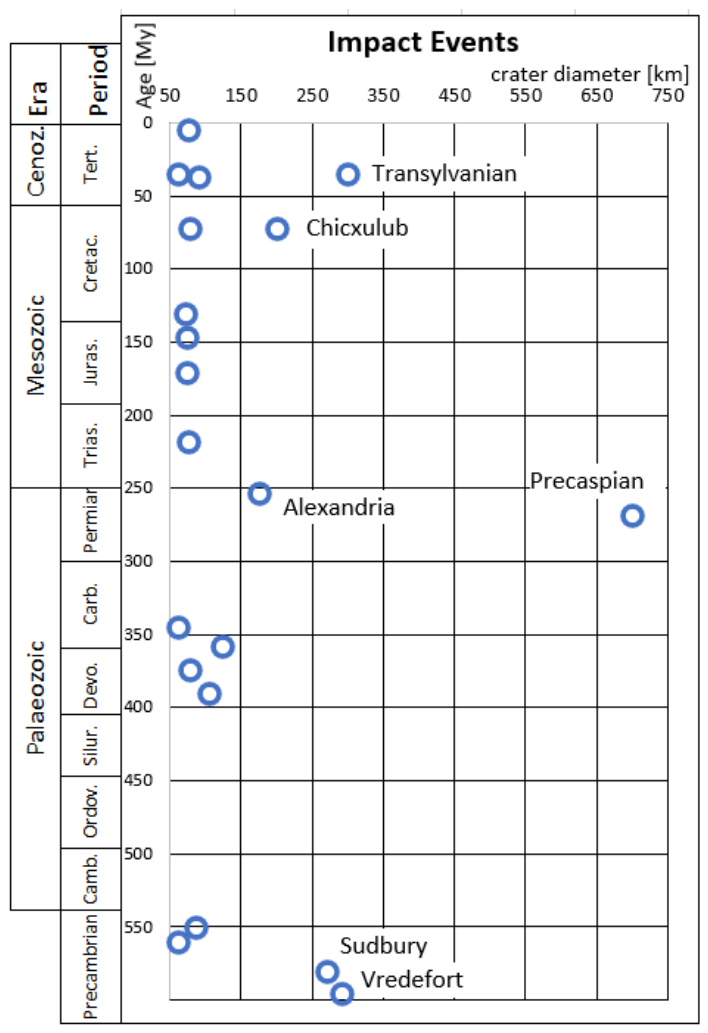
Figure 2.
High intensity extinction events during geological time. Modified after [8].
Figure 2.
High intensity extinction events during geological time. Modified after [8].
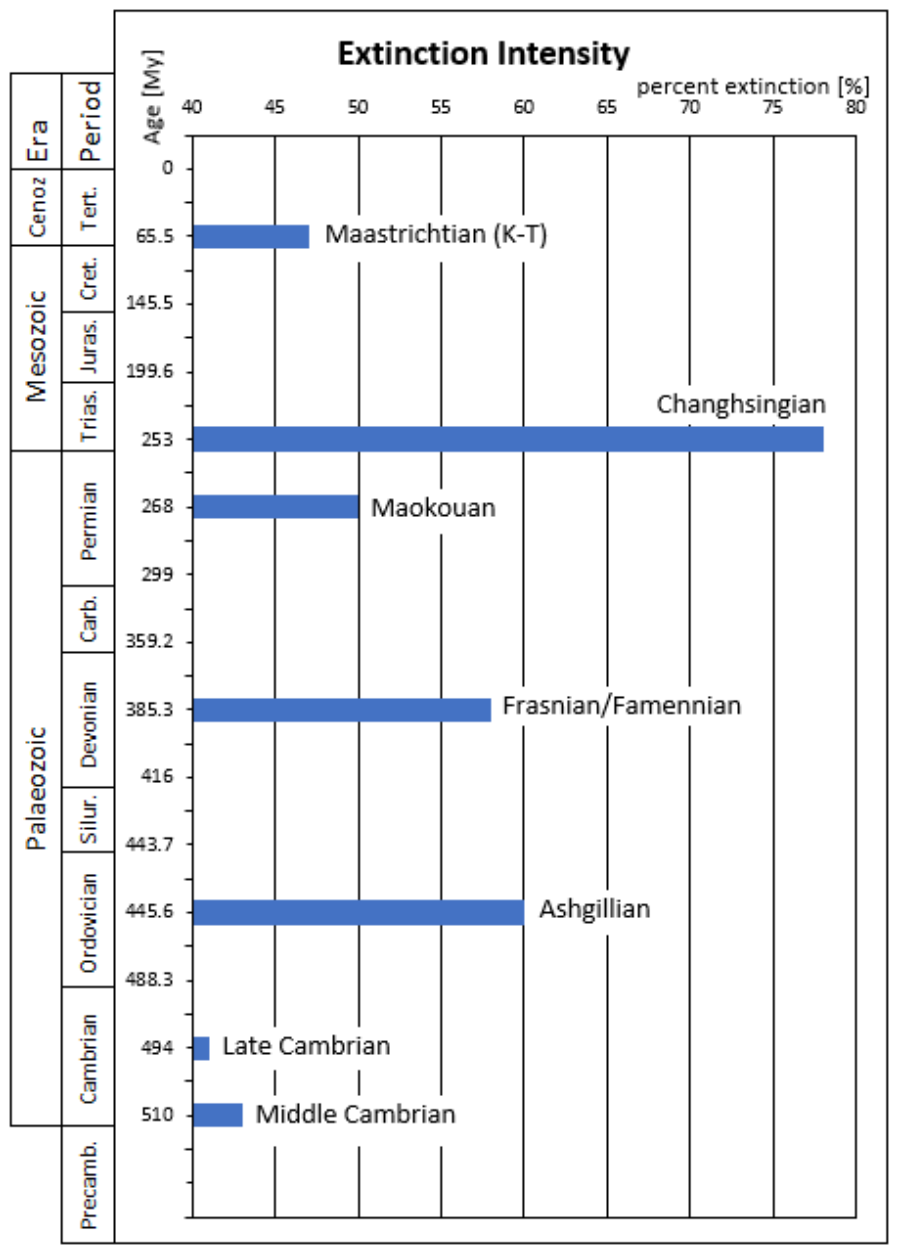
Figure 3.
Total field regional magnetic map in the Precaspian Depression area [29]. Black line: direction of the refraction seismic section.
Figure 3.
Total field regional magnetic map in the Precaspian Depression area [29]. Black line: direction of the refraction seismic section.
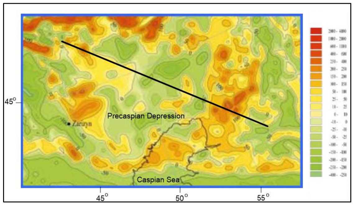
Figure 4.
Crustal section across the Precaspian Depression based on refraction seismic [32]. Magnetic profile data from [29]. Geological data from [26]. Thick black lines: crustal faults; thin black lines: crustal boundaries; red line: total magneic field profile; black +: granitic crustal layer; black V: basaltic crustal layer; black L: upper mantle; yellow layer: sedimentary cover.
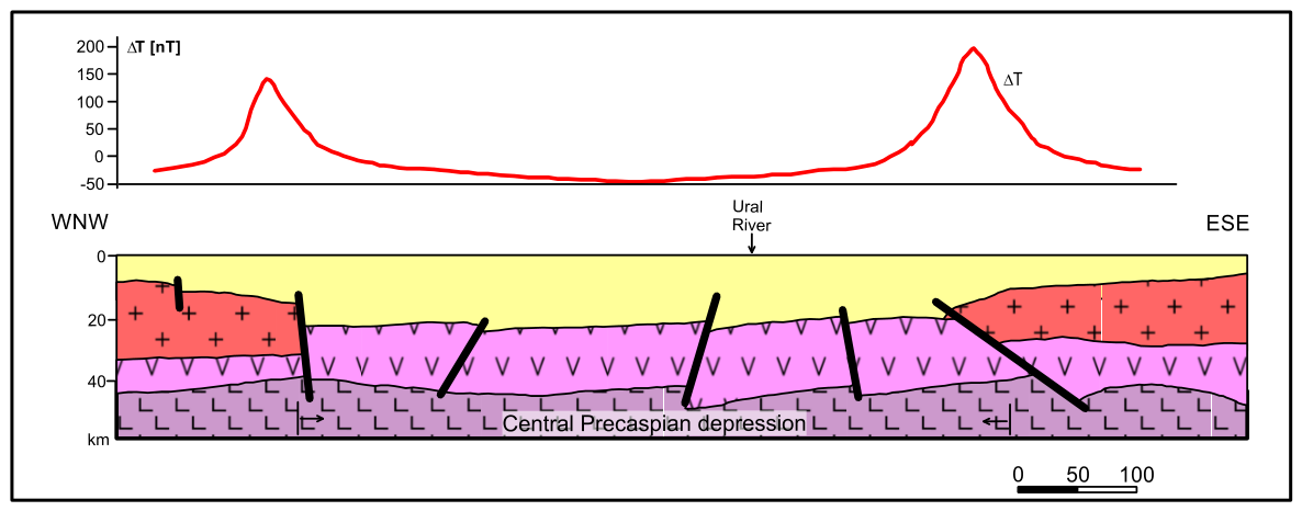
Figure 5.
Residual map for the vertical compenent of magnetic field, based on [37]. Purple line: interpreted boundary of the Alexandria impact structure [6].
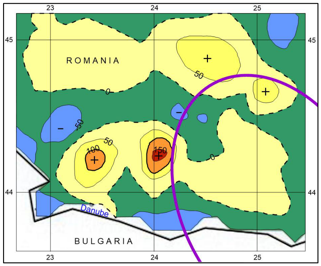
Figure 6.
Aeromagnetic map of the Transylvanian Depression reduced to the pole [7]. Red line: direction of geologic section and 2D magnetic modelling.
Figure 6.
Aeromagnetic map of the Transylvanian Depression reduced to the pole [7]. Red line: direction of geologic section and 2D magnetic modelling.
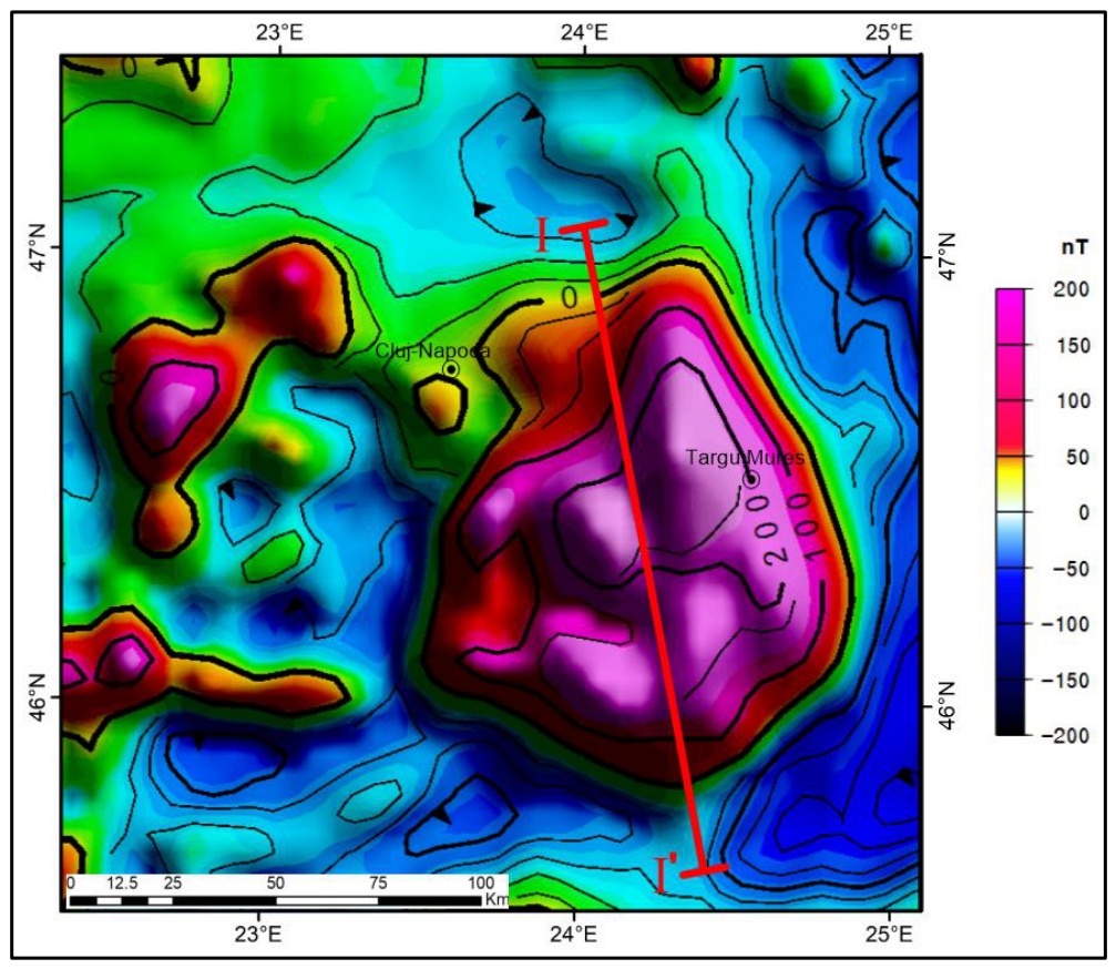
Figure 7.
Magnetic 2D modelling along a geological section across the Transylvanian Depression. Redrawn geological data after [39] and geophysical data after [41].
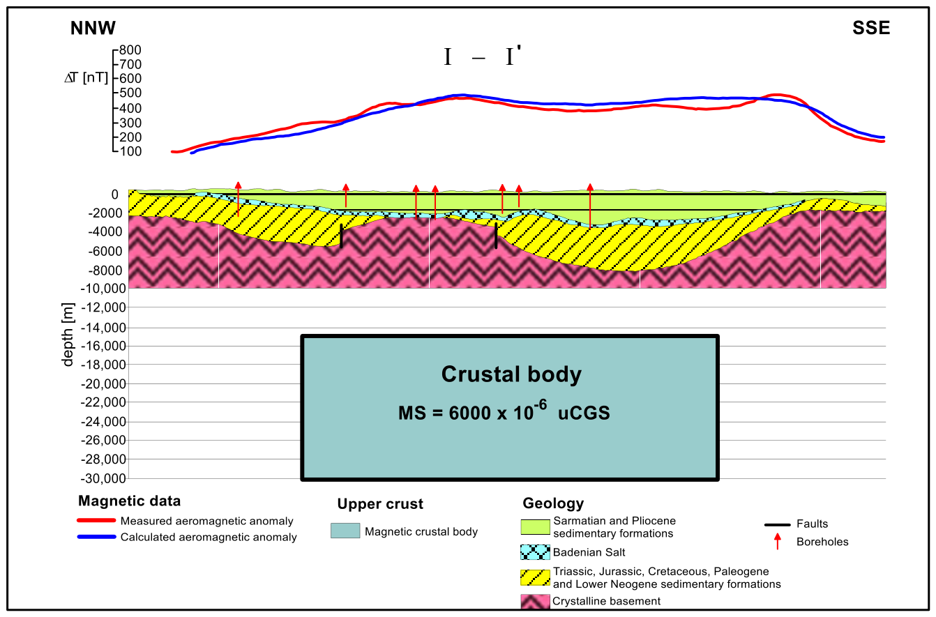

Table 1.
Selected magnetic susceptibilities of rocks [14].
Table 1.
Selected magnetic susceptibilities of rocks [14].
| Rock type | Susceptibility x 10-6CGS | ||
|---|---|---|---|
| Range | Average | ||
| Metamorphic | Schist | 25 - 240 | 120 |
| Sedimentary | Dolomite | 0 - 75 | 10 |
| Limestone | 2 - 280 | 25 | |
| Sandstone | 0 - 1600 | 30 | |
| Igneous | Granite | 0 - 4000 | 200 |
| Diorite | 50 - 10,000 | 7000 | |
| Gabbro | 80 - 7200 | 6000 | |
Disclaimer/Publisher’s Note: The statements, opinions and data contained in all publications are solely those of the individual author(s) and contributor(s) and not of MDPI and/or the editor(s). MDPI and/or the editor(s) disclaim responsibility for any injury to people or property resulting from any ideas, methods, instructions or products referred to in the content. |
© 2026 by the authors. Licensee MDPI, Basel, Switzerland. This article is an open access article distributed under the terms and conditions of the Creative Commons Attribution (CC BY) license (http://creativecommons.org/licenses/by/4.0/).
Copyright: This open access article is published under a Creative Commons CC BY 4.0 license, which permit the free download, distribution, and reuse, provided that the author and preprint are cited in any reuse.