

Submitted:
01 October 2026
Posted:
06 October 2026
You are already at the latest version
Abstract
Thermokarst is a leading destructive geomorphic process in permafrost regions, triggered by the melting of ground ice. Ice-wedge thermokarst features, such as thermokarst lakes and drained-lake basins, are the most abundant thermokarst landforms in the Arctic. In this study, we reassess interactions among factors that drive thermokarst development and evaluate the role of ice-wedge systems in thermokarst-lake formation and evolution. We summarize the factors affecting thermokarst and evaluate mechanisms that facilitate thermokarst-lake development in landscapes of the continuous permafrost zone with abundant ice wedges. Specifically, we (1) review the conditions governing thermokarst development, including climate, ground-ice content, and regional variability; (2) compare the roles of vegetation, soil, snow, water, and disturbance in initiating thermokarst; and (3) examine the patterns and processes governing thermokarst-lake development in the continuous permafrost zone, where ice wedges are abundant and strongly control landscape evolution. Once thermokarst is initiated, both ice wedges and segregated ice are important to the formation and evolution of thermokarst lakes, whereas ice wedges alone are rarely responsible for lake formation. We identify key processes in thermokarst-lake formation in ice-wedge environments and synthesize their roles into a new conceptual model that better accounts for patterns observed across lake-dominated Arctic landscapes.
Keywords:
ground ice
; thermokarst
; thaw lakes
; ice wedges
This paper is dedicated to Dr. Jerry Brown in recognition of his pioneering contributions to permafrost science and his lifelong selfless service to the International Permafrost Community.
Epigraph: “The mechanisms behind the growth, expansion, and eventual drainage of thaw lakes are not fully understood.” Hugh French (2018, page 189).
1. Introduction
Lakes are abundant features in ice-rich permafrost areas of the Arctic and boreal regions (Kachurin, 1961; Mackay, 1963; Black, 1969; Tomirdiaro, 1972; Burn, 1992; Hinkel et al., 2005; Kravtsova, 2009; Jones et al., 2011, 2022; Grosse et al., 2013). These lakes are usually identified as thermokarst (thaw) lakes because they occur widely in areas with ice-rich permafrost containing abundant massive ice (mostly in the form of ice wedges). Yet, thermokarst lakes exhibit rich morphological diversity, and their initiation, development, and distribution in relation to terrain characteristics remain poorly understood (Plug and West, 2009; Grosse et al., 2013; French, 2018). Furthermore, differentiation between thermokarst and non-thermokarst lakes can be problematic given their relationships with ground ice (Jorgenson and Shur, 2007). Here, we examine the patterns and processes governing thermokarst-lake development in the continuous permafrost zone, where ice wedges are abundant and strongly control landscape evolution.
The processes and patterns involved in permafrost degradation create a wide variety of thermokarst landforms depending on climate, topography, surficial geology and soil texture, and ground-ice morphology and abundance (Shur and Osterkamp, 2007; Jorgenson, 2021; Lu and Han, 2025). Landforms on flat terrain vary from thermokarst bogs and fens in boreal regions to polygonal troughs and thermokarst lakes in the Arctic, with thaw slumps mostly limited to slopes in the Arctic, particularly in areas with buried glacial ice (Jorgenson, 2008; Farquharson et al., 2016; Coulombe et al., 2019). Thermokarst lakes are the most widespread and distinct landform in both boreal and Arctic regions, with changes readily detected through remote sensing (Bryksina and Polishchuk, 2009; Jones et al., 2011; Grosse et al., 2013; Viktorov et al., 2015; Veremeeva et al., 2021; Liu et al., 2025).
Thermokarst lakes form across a range of terrain, from flat coastal plain deposits where ice wedges provide most of the excess ice, to upland yedoma with tall syngenetic ice wedges, to lacustrine and marine-related deposits where segregated ice is particularly abundant (Jorgenson and Shur, 2007; Kanevskiy et al., 2013a). Thermokarst lakes tend to be round to elliptical, range from shallow (0.5–2 m) to very deep (up to 10 m or more), and are mostly found on flat terrain where water is easily impounded, although they can also occur on ridges and slopes (Carson and Hussey, 1962; Black, 1969; Tedrow, 1969; Harry and French, 1983; Hinkel et al., 2005; Grosse et al., 2013; Coulombe et al., 2022). Of particular interest is the relationship between ice-wedge degradation and thermokarst lakes, because they are the most abundant thermokarst landforms in the Arctic (Witharana et al., 2021; Wang et al., 2023) and ice wedges contribute a large proportion of the excess ice (Kanevskiy et al., 2013b; Couture and Pollard, 2017). Also, they are most sensitive to climate warming and disturbance (Liljedahl et al., 2016; Kanevskiy et al., 2017; Jorgenson et al., 2022a).
To clarify the factors driving ice-wedge degradation and the progressive development of thermokarst lakes, we use the terms ‘thermokarst’ and ‘thermal erosion’ to distinguish two dominant processes. Ermolaev (1932) first coined the term ‘thermokarst’ to describe landforms formed by the collapse of yedoma driven by thermal processes. It has since been used broadly to encompass all processes and landforms resulting from the thawing and collapse of ice-rich permafrost terrain (Murton, 2008; Kokelj and Jorgenson, 2013; Jorgenson, 2021; Lewkowicz et al., 2025). Here, we use thermokarst in a more restricted sense to refer to subsidence from thaw settlement alone (Sumgin et al., 1940; Soloviev, 1962; Popov, 1967; Dostovalov and Kudryavtsev, 1967; Katasonov, 1978; Baulin and Murzaeva, 2003), while using thermal erosion to distinguish processes involved in lateral permafrost degradation (Czudek and Demek, 1970; Are, 1974).
While ice-wedge thermokarst is widespread across the Arctic (Jorgenson et al., 2006; Liljedahl et al., 2016; Frost et al., 2018), we have observed that new thermokarst-lake formation is relatively uncommon. This apparent contradiction raises a major question about which processes trigger the transformation of water-filled thermokarst pits and troughs above degrading ice wedges into large ponds and lakes. Thus, we argue that progress in thaw-lake research requires reevaluating the role of ice-wedge systems in thermokarst-lake formation. In this review, we synthesize existing observations and propose a conceptual framework to explain how ice-wedge degradation may initiate and sustain thermokarst-lake development in the continuous permafrost zone. Our goal is to summarize the factors affecting thermokarst and evaluate the mechanisms that facilitate thermokarst-lake development in landscapes with abundant ice wedges. Specifically, we (1) review the conditions governing thermokarst development, including climate, ground-ice content, and regional variability; (2) compare the roles of vegetation, soil, snow, water, and disturbance in initiating thermokarst; and (3) evaluate the role of ice wedges in the formation and evolution of thermokarst lakes in the continuous permafrost zone.
2. Conditions for Thermokarst Development
The two most important factors in thermokarst development are the soil’s temperature regime and the abundance of ground ice (Sumgin et al., 1940). Differences in climate and ground-ice contents between the continuous and discontinuous zones have major ramifications for thermokarst development in these two regions.
2.1. Climate and Soil Climate
To better understand the relationship between climate and permafrost, Shur and Ping (1994) classified climates into three categories: favorable, neutral, and unfavorable for permafrost occurrence. In unfavorable climates, permafrost can exist only under specific conditions, such as in certain caves or in hypersaline lacustrine environments (Dzens-Litovskiy, 1938). Under neutral conditions, permafrost occurs in some areas and is absent in others. In favorable climates, permafrost occurs everywhere on land and beneath shallow water. The continuous permafrost zone has a climate that favors permafrost formation (roughly colder than -7 °C MAAT). In this climate, factors such as vegetation, soil, and topography influence active-layer depth and permafrost temperature, but they do not determine whether permafrost exists. In a neutral climate, typical of the discontinuous permafrost zone, permafrost can form or persist only in ecosystems with specific combinations of snow cover, relief, vegetation, and soil types. Therefore, vegetation, soil, and snow influence the presence of permafrost, and changes in these factors can cause its degradation. In some areas with a neutral climate, vegetation and the soil organic layer protect ice-rich relict permafrost formed over 10,000 years ago (Shur and Jorgenson, 2007).
Koloskov (1924) and Zolnikov et al. (1962) distinguished between an “air climate” and a “soil climate” because permafrost is not in direct contact with the atmosphere. The air climate results from solar radiation and air circulation, with precipitation as another component. The soil climate, which determines the soil’s thermal and moisture regime, is not simply derived from the atmospheric climate but is modified by the soil surface and processes within the active layer. Relief, vegetation, snow, and soil properties also affect it by modifying the air climate (Figure 1). We consider these factors to be “modifiers” of the air climate (Shur and Osterkamp, 2007). Together, these modifiers create an ecosystem consisting of relief, vegetation, soil, and permafrost (Loranty et al., 2018). Snowfall serves as both a climate component and a modifier, with snow thickness and density influenced by wind, temperature, relief, and vegetation. Human activities and infrastructure also significantly affect snow distribution and density.
Because permafrost depends on soil climate, which is influenced by air climate and modifiers, it is difficult to identify what triggers changes in permafrost conditions: climate change or changes in modifiers. Modifiers can reverse the effect of climate variations on soil climate and permafrost. For example, Shur (1988a) observed a short-term summer frozen layer (pereletok) at the base of the seasonally frozen layer in the permafrost-free Nadym River Valley, West Siberia, Russia, that formed and persisted during very warm, dry summers but not during cold ones. In dry, warm summers, the thermal conductivity of peat and desiccated moss is very low, which inhibits thawing more strongly than the increase in air temperature can accelerate it.
Most thermokarst-driver classifications treat climate change as a global or regional driver, whereas changes in environmental modifiers are treated as local controls (French, 2018; Murton, 2008; Shur and Osterkamp, 2007). Tomirdiaro (1972), Tyrtikov (1976), Burn (1992), Allard et al. (1996), Jones et al. (2015), and others have demonstrated that local causes can initiate thermokarst. As French (2018) observed, the local causes of thermokarst are numerous but can be grouped into a few categories. These causes mainly involve changes in modifiers or the introduction of new modifiers. They include reducing or eliminating the summer thermal resistance of the soil surface organic layer, decreasing the thermal resistance of the active layer, increasing the thermal resistance of snow, and introducing new modifiers, such as water ponding on the soil surface. These changes can result from natural processes or human activities (Raynolds et al., 2014; Jones et al., 2025), and any of them can disrupt the thermal balance between permafrost and the air climate, leading to permafrost degradation.
Climate drivers and changes in modifiers that trigger thermokarst differ in the areas they affect and in the severity of their impacts. Climate change operates over large regions, whereas changes in modifiers are usually localized. However, changes in modifiers often have a more severe impact on permafrost than contemporary climate change. For example, on Alaska’s Arctic Coastal Plain within the continuous permafrost zone, active-layer depth ranges from ~20 to 60 cm beneath vegetation but approaches ~1 m at bare sites (Hinkel and Nelson, 2003). Mackay (1970) described a site where active-layer thickness doubled after the organic layer was burned out. Removing vegetation, which has a thermal resistance of 0.4 m2·K/W and a thermal conductivity of thawed soil in the active layer of 1.0 W/m·K, increases active-layer depth from 60 to 100 cm. To achieve the same effect by increasing summer air temperatures without altering vegetation cover, the Thawing Index should increase by roughly a factor of 2 (Shur, 1977). Increasing active-layer thickness from 40 cm (with a thermal resistance of 1 m2·K/W and a thermal conductivity of 1.0 W/m·K) to 100 cm, without vegetation removal, requires a 3-fold increase in the Thawing Index. This is incomparably greater than the increase in summer air temperatures due to current climate change (Chapin et al., 2005; Smith et al., 2022).
It is common to consider the impacts of climate change and local factors separately, but climate change can amplify local effects. For example, in Central Yakutia, thermokarst that stabilized after land development on agricultural fields and in villages has recently reactivated without new human impacts (Fedorov, 2020; Desyatkin and Fedorov, 2023).
2.2. Ground Ice
According to Dostovalov and Kudryavtsev (1967), two main conditions for thermokarst development are the presence of excess ground ice and a seasonal thaw depth that exceeds the normal depth to the ice-rich permafrost. Subsidence due to ice melting is required for the initial development of thermokarst and the formation of a thermokarst lake.
According to Popov et al. (1985, p. 208), “… a high content of ground ice is a key factor for thermokarst. Subsidence of thawing ice-rich soils always results from a change in active-layer thickness or an increase in the depth of seasonal thawing that exceeds the previously settled depth for some reason. When the active-layer thickness increases and reaches ice-rich soil or massive ice, subsidence occurs. An increase in the active-layer thickness is always caused by a change in the soil’s thermal regime. So, changes in the soil’s thermal regime and increases in active-layer thickness are the main drivers of thermokarst. Deepening the seasonal thaw increases surface subsidence during ice melting. This leads to further downward displacement of the active layer, deeper thawing, and more subsidence.”
The condition for thermokarst initiation can be formulated as: thermokarst begins when, for one reason or another, massive ground ice melts or ice-rich soil thaws. This usually occurs in a limited area. This condition can be represented in the most general form as the area of thawing soil intersecting with the area underlain by massive ice or ice-rich soil (Shur, 1977):
where Ath = area of soil thawing;
Ath ∩ Aice ≠ ∅,
Aice = area with massive ice or ice-rich soil.
Equation (1) indicates that the thawing area overlaps with ice-rich soil or massive ice. It does not specify the direction of thawing. The equation applies to any thermokarst process and is consistent with the thermokarst definition in the new glossary on permafrost (Lewkowicz et al., 2025, page 101): “Processes and landforms that result from the thaw of ice-rich permafrost.” Any specific form of thermokarst requires additional geomorphic, permafrost, and, in some cases, hydrologic conditions (Chen et al., 2020, 2021).
The thermal conditions for thermokarst-lake formation are usually defined more narrowly. According to Hinkel et al. (2012, p.221), “Lake development is associated with local or regional deepening of the active layer and thermokarst activity associated with the upper, ice-rich layer of permafrost (Burn, 1997; Côté and Burn, 2002; French, 2007; Jorgenson and Shur, 2007; Plug and West, 2009).” This condition can be described as:
where Hth = an initial thickness of the active layer;
Hth + Δh > hice,
Δh = an increase in the thickness of the active layer;
hice = a depth to massive ice or ice-rich soil.
The ground ice varies in origin and properties (Shumskii and Vtyurin, 1966; Mackay, 1972; Vtyurin, 1975; Zhestkova, 1982; Murton, 2013; French, 2018). The shape, volume, and position of ground ice relative to the soil surface are important for thermokarst (e.g., wedge ice versus lenses of segregated ice). Shur and Osterkamp (2007) summarized different types of ground-ice distribution (Figure 2).
Types I.1 to I.3 (Figure 2) present the sequences and the relative abundance of segregated ground ice, including pore ice and visible ice lenses and inclusions. Type I.1 features ice-poor permafrost dominated by pore ice. Thaw settlement of such soil is negligible, and down-wearing thermokarst cannot occur. However, thermal erosion, a subtype of thermokarst, remains possible. Type I.2 represents a common situation in which an ice-rich intermediate layer (Shur, 1988a,b; French and Shur, 2010; Shur et al., 2011, 2021; Murton, 2013) overlies ice-poor permafrost. Thawing of the ice-rich upper layer can cause thaw settlement and the development of micro-relief features that may affect the integrity of roads and airfields. Type I.3 represents permafrost rich in segregated ice inclusions. A prominent example is glacial-lacustrine deposits with thick layers of segregated ice (Shur and Zhestkova, 2003; Kanevskiy et al., 2013a).
Types II.1 to II.5 (Figure 2) represent sequences containing both massive and segregated ice. Type II.1 features thaw-stable, ice-poor soils containing ice wedges. Type II.2 represents ice-poor soils containing ice wedges, overlaid by the ice-rich intermediate layer. Type II.3 shows ice wedges enclosed in ice-rich soil. Types II.4 and II.5 represent bodies of tabular massive ice (e.g., buried glacier ice) overlaid by ice-poor and ice-rich soils, respectively. Areas with tabular massive ice and wedge ice differ in thermokarst development (Shur, 1988a).
A high amount of ground ice in the upper permafrost is necessary but not sufficient for a thaw lake to form. It is merely a potential that must be released. Poltev (1963) observed that further north, thermokarst related to the thawing of segregated ice becomes less common, and thermokarst associated with ice-wedge melting prevails.
2.3. Differences Between Continuous and Discontinuous Permafrost Zones
Permafrost formation and persistence, as well as thermokarst development, differ between continuous and discontinuous permafrost zones. In this context, we consider sporadic and isolated permafrost to be part of the discontinuous permafrost zone, as originally defined (Sumgin et al., 1940). This distinction is more significant than variation in areal permafrost coverage. In the continuous zone, climate alone can control permafrost development (climate-driven permafrost), whereas in the discontinuous permafrost zone, environmental factors, mainly peat-forming vegetation, are necessary for the formation of relatively warm ecosystem-driven permafrost and its persistence (Shur and Jorgenson, 2007). In the discontinuous permafrost zone, ecosystems support relatively warm permafrost (Shur and Jorgenson, 2007).
This distinction also reflects how thermokarst develops in permafrost zones and highlights the relationship between thermokarst and permafrost degradation, a topic that is both important and controversial. In this paper, we define permafrost degradation as the lowering of the permafrost table accompanied by the development of a closed talik (a layer of unfrozen ground between the active layer and the lowered permafrost table). This abridged definition of permafrost degradation clarifies subsequent discussion.
As Kachurin (1955, p. 25) noted: “It is widely accepted that thermokarst, i.e., subsidence features on the Earth’s surface caused by melting ice in frozen soil, indicates permafrost degradation. This is almost always mentioned in discussions of the extent of thermokarst development. In many cases, this is true. However, the question remains: Is thermokarst always a sign of permafrost degradation? Can the simple presence of thermokarst confirm the degradation process?”
By raising this issue, Kachurin (1955) disputes his late mentor, Sumgin, without naming him. Sumgin (1937, page 246) wrote: “We have already discussed the relationship between permafrost and the modern climate, specifically climate warming and its impact on permafrost. Indeed, researchers have long observed a number of phenomena indicating a rise in permafrost temperatures, from negative to positive values. Degradation lowers the permafrost table and forms sinkhole lakes. The external demonstration of these phenomena is that a certain area begins to subside gradually, forming a depression in the middle of a level area. This depression is sometimes quite deep and is filled with water, forming a lake.”
Kachurin’s question could be rephrased as: Is thermokarst a result of regional permafrost degradation or a cause of local permafrost degradation? In the discontinuous permafrost zone, thermokarst initiation often stems from permafrost degradation, which begins when the mean annual ground temperature at the permafrost table exceeds 0 °C. As a lake develops, thermokarst becomes an additional long-term driver of degradation.
Kachurin (1955) thoroughly examined the relationship between thermokarst and permafrost degradation and evaluated three cases of thermokarst development: first in the discontinuous permafrost zone, second in the southern part of the continuous permafrost zone, and third in its northern part. He demonstrated that in the discontinuous permafrost zone, permafrost is highly sensitive to local conditions, such as vegetation, and that local impacts, such as fire, can degrade it. Damage to surface vegetation and the organic layer often causes at least temporary permafrost degradation, with deepening of the permafrost table and the development of a talik. This does not occur in the continuous permafrost zone. Kachurin (1955, p. 25) wrote: “…simply having thermokarst in an area doesn’t prove that the permafrost is degrading naturally. So, the answer to whether thermokarst always indicates permafrost degradation is no. The presence of thermokarst alone is not a reliable or sufficient sign of permafrost degradation in current climate conditions.” Kudryavtsev (1962) agreed with this statement.
Soloviev (1950), in his detailed study of the geomorphic features of thermokarst landscapes in the watersheds of the Lena and Amga Rivers, also questioned the relationship between permafrost degradation and aggradation, and between thermokarst driven by local factors and the then-accepted interpretation linking thermokarst to regional permafrost degradation. He concluded that thermokarst formation there was driven by local factors such as wildfire or land use. He also noted that climate-change-induced thermokarst would take different forms.
Therefore, the relationship between thermokarst and permafrost degradation is bidirectional, as permafrost degradation can cause thermokarst, or thermokarst can cause local degradation. The first case is typical of discontinuous permafrost. The second case occurs under lakes in the continuous permafrost zone, where lake depth exceeds a critical level, which Kudryavtsev (1954) defined as the depth of water at which the soil’s seasonal thawing under water equals the depth of seasonal freezing. When a lake’s depth exceeds this critical level, a talik forms under the lake, indicating that permafrost degrades beneath the lake (Kudryavtsev, 1962; Sellmann et al., 1975).
Unlike the discontinuous permafrost zone, the continuous permafrost zone typically does not experience talik formation or permafrost degradation in response to changes in modifiers. Instead, at sites with segregated ice only, such changes result in temporary increases in active-layer thickness, which may cause only limited thaw subsidence (Shur, 1988a; Jones et al., 2025). The magnitude of this subsidence depends on the ice content of the upper permafrost. Thermokarst can persist there only if massive ice is within reach of the thickening active layer. It can also occur in specific cases, such as significant snow accumulation, for example, next to snow fences (Hinkel and Hurd, 2006), or the complete removal of the active layer, with water filling the cut (Bosikov, 1996). Sites with ice wedges present a special and complicated case. In the central parts of polygons, fire or human impact increases the active-layer thickness, while adjacent ice wedges can degrade, resulting in differential thaw settlement (Jones et al., 2015, 2024). In this paper, we will discuss in detail the causes and consequences of ice-wedge thermokarst in the continuous permafrost zone.
Thermokarst in the discontinuous permafrost zone often leads to talik formation and temporary or permanent permafrost degradation through downward thawing, which proceeds relatively quickly in ice-poor mineral soils. Most studies link thermokarst causes to increased active-layer thickness. However, Shur (1988a) indicated that conductive heat transfer through the active layer is the least effective way to thaw frozen ground, and that the rate of permafrost thawing is dozens to thousands of times greater at direct contact with air, still water, and especially moving water. Shiklomanov and Nelson (2013) concurred.
In natural settings, these effective mechanisms of permafrost degradation occur along the shores of seas, lakes, and rivers, a phenomenon long recognized (Wallace, 1948; Are, 1974; Vasiliev et al., 2006, 2017; Lantuit and Pollard, 2008; Jones et al., 2008, 2009; Kanevskiy et al., 2016; Shur et al., 2002, 2021). Recently, it has been shown that in the discontinuous permafrost zone, erosion by still water is the primary process driving lateral degradation of peat plateaus and palsas at their contact with waterlogged bogs (Camill, 2005; Jin et al., 2006; Borge et al., 2017; Kurylyk et al., 2016; Martin et al., 2019, 2021; De la Barreda-Bautista et al., 2022; Jorgenson et al., 2022b; Halaś et al., 2025; Shirley et al., 2021). These studies, mainly conducted by biologists and hydrologists, have contributed significantly to permafrost science. We agree with Kurylyk et al. (2016) that most studies on permafrost thaw have focused on changes in active-layer thickness and that lateral permafrost degradation, except for coastal thermal erosion, has been overlooked.
Lateral degradation of peat plateaus includes underground erosion by still water beneath the edges of plateaus and the collapse of unsupported peat above thawed peat (Wallace, 1948). Permafrost degradation on a peat plateau is not limited to lateral erosion. It can occur across the entire surface of the underground frozen bulb where it contacts a water-bearing bog, including the bottom of the bulb (Eklof et al., 2024).
As noted above, thermokarst in the discontinuous permafrost zone often results from permafrost degradation. In the continuous permafrost zone, even severe impacts on the soil surface produce only limited thermal subsidence, and additional factors are required to trigger further permafrost thawing and settling (Jones et al., 2024). Theoretically, continuous thawing can be sustained either by deepening the seasonal soil thaw depth or by reducing seasonal freezing to a depth shallower than the seasonal thaw depth. Snow or water layer on the soil surface can effectively enhance thermokarst if their thickness exceeds critical thresholds (Kudryavtsev, 1954). Current explanations of thermokarst-lake formation treat changes in snow thickness and water accumulation as essential drivers of thermokarst development (Hopkins, 1949; Soloviev, 1950, 1962; French, 2018).
3. Surface Factors Affecting Thermokarst
3.1. Vegetation and Soil Natural Dynamics
Vegetation and soil organic matter are particularly effective at modifying soil thermal regimes but are highly vulnerable to change (Shur and Jorgenson, 2007; Jorgenson et al., 2010). However, most well-documented cases of thermokarst initiation caused by significant changes in vegetation and the soil organic layer are linked to fire and disturbance (Soloviev, 1950; Kachurin, 1955; Burn, 1988), and not to natural dynamics.
Vegetative succession usually increases the thermal resistance of vegetation and the soil’s organic horizon and reduces active-layer thickness, which commonly prevents thermokarst initiation (Shur, 1988a). Additionally, vegetative succession indirectly affects the soil’s thermal regime by influencing snow cover, microrelief, and water accumulation on the soil surface. The combined (direct and indirect) effects may occasionally create conditions favorable for thermokarst development (Allard et al., 1996; Tyrtikov, 1969).
Some permafrost scientists believe that natural vegetation disturbance, even in a very small area, can trigger thermokarst-lake formation. According to Wallace (1948, p. 180), “The effect of removal of the vegetal cover has been demonstrated in many places where caving has taken place in ground from such an event as the overturning of a tree by wind, with resulting uprooting of the vegetal mat.” Pisarev (1935), Pchelintsev (1946), and Hopkins (1949) also considered such a possibility. Impacts of disturbances and fire on vegetation and soils that may result in thermokarst initiation are discussed in detail below (see section 3.4. Disturbance and Fire).
3.2. Snow
Snow is a crucial factor in soil thermal regimes because winter temperatures dominate the heat balance of northern soils (Dostovalov and Kudryavtsev, 1967; Nicholson and Granberg, 1973; Park et al., 2015). In Alaska’s permafrost region, the ratio of freezing index to thawing index ranges from 1.5 at Fairbanks to 19 at Utqiaġvik (Barrow) (Nidowicz and Shur, 1998), favoring permafrost stability. But snow can overcome this advantage, especially in the discontinuous permafrost zone. Based on thermal modeling, Jorgenson et al. (2010) estimated that snow depth strongly controlled ground temperatures (at 2-m depth), with 50 cm of snow increasing the mean annual ground temperature by 5 °C. Seasonal timing, however, also matters because early, thick snow cover in early winter can greatly reduce soil heat loss, whereas early snowless winters allow rapid cooling. Thus, both snow depth and seasonal timing matter for reducing heat loss from soils during winter cooling.
Allard et al. (1996, p. 225) showed that thermokarst on a permafrost plateau in Northern Quebec was initiated by forest expansion and growth and closely related to snow thickness: “As trees and shrubs become denser, they retain locally a thicker snow cover, which warms the profile. Eventually, layer II begins to melt. The initial settlement then forms shallow depressions that improve growing conditions and create a deeper snow patch. Sometime later, when snow depth exceeds 70 cm, freeze-back of the active layer is definitely prevented as the ground surface is insulated from freezing air temperatures.” Tyrtikov (1969) described similar processes in the discontinuous permafrost zone of West Siberia.
3.3. Water
Water significantly affects the depth of the active layer and the permafrost temperature (Hopkins, 1949; Are and Tolstyakov, 1969; Bosikov, 1991; Harris, 1982, 2002; De Grandpré et al., 2012; Chen et al., 2020, 2021). Katasonov et al. (1979) stated that only the accumulation of surface water at sites with massive ice causes the formation of thermokarst ponds and lakes. Permafrost in the discontinuous zone deteriorates even beneath shallow ponds or lakes. In the High Arctic, only lakes deeper than about 1.5 meters develop a closed talik. In the harsh climate of Central Yakutia, the average annual temperature of water at the bottom of a shallow lake is about 8 to 10 °C higher than the average annual temperature of nearby shore soil (Bosikov, 1991). In northern Alaska (Prudhoe Bay area), Jorgenson et al. (2015) found that mean annual temperatures at the bottom of water-filled thermokarst pits over degrading ice wedges were ~8 °C warmer than those in surface soils on adjacent polygon centers. In Interior Alaska, this temperature difference was at least 6 °C (Osterkamp et al., 2000). Thus, a persistent water layer greatly influences the soil climate and often initiates thermokarst development.
3.4. Disturbance and Fire
Vegetation and peat strongly influence soil climate and are among the most vulnerable modifiers. Fire or animals can destroy them, human activities can strip them away, and they can be altered. As Wallace (1948), Hopkins (1949), Mackay (1970), Brown and Grave (1979), Soloviev (1962), Tomirdiaro and Ryabchun (1978); Czudek and Demek (1970), Fedorov (2020), Burn and Smith (1990), and Allard et al. (1996) have shown, local factors (changes in modifiers), rather than climate change, are often responsible for thermokarst development. Hopkins (1949) identified frost heaving as a disruption of the vegetal cover that can create bare-soil areas, which then subside sufficiently upon thawing to collect small pools of water that facilitate further thawing.
According to Péwé (1954, p. 329-330), “The thawing of permafrost creates thermokarst topography, an uneven surface which contains mounds, sink holes, tunnels, caverns, and short ravines caused by melting of ground-ice. Thawing may result from artificial or natural removal of the vegetation or from warming of the climate. Removal of the insulating blanket of vegetation by forest fire or by man allows the ground to absorb more solar heat. Ground-ice melts, and segments of the ground surface settle or cave. Cultivation probably causes more rapid and extensive thawing than forest fires because, before cultivation, man completely removes the vegetative cover and thereafter exposes the bare ground annually. Thawing and caving proceed most rapidly and deeply, therefore, in artificially cleared areas.”
In natural conditions within the discontinuous permafrost zone, wildfires have the greatest impact on permafrost, causing either temporary or permanent degradation (Yoshikawa et al., 2003). According to Tyrtikov (1969, p. 97), “After the vegetation cover and peat have burned away, thawing dominates over freezing for many decades, and taliks form. The permafrost state that existed before the vegetation was destroyed is often only restored after hundreds of years.” Tyrtikov (1969) also found that in well-drained areas with coarse soils, permafrost does not form during the restoration and development of forest vegetation after a fire. Shur and Jorgenson (2007) concluded that repeated fires during the Holocene shaped current patterns of permafrost distribution in Alaska’s discontinuous permafrost zone, where permafrost formed during the late Pleistocene, when this area belonged to the continuous permafrost zone.
After a fire, permafrost can degrade several meters deep before beginning to recover (Tyrtikov, 1969; Viereck, 1973; Burn, 1988; Viereck et al., 2008; Yoshikawa et al., 2003). The degradation can continue for decades or even centuries until protective vegetation regrows (Tyrtikov, 1969; Viereck, 1973; Douglas et al., 2008; Osterkamp and Romanovskiy, 1999; Shur and Zhestkova, 2003). With sufficient ground ice in the upper permafrost affected by thermokarst, thaw lakes can form (Wallace, 1948; Burn and Smith, 1990).
The initiation of thermokarst by fire has been observed in various parts of the Russian permafrost region (Pisarev, 1935; Efimov, 1946; Tyrtikov, 1976; Moskalenko, 1999) and in Alaska (Viereck, 1973; Dyrness, 1982; Yoshikawa et al., 2003; O’Donnell et al., 2011; Jorgenson et al., 2013; Jones et al., 2013, 2015, 2024). Burn and Smith (1990) studied thermokarst lakes near Mayo, central Yukon, Canada, and concluded that “the most recent initiation of thermokarst activity is related to the effects of forest fires” (p. 161). Numerous thaw lakes in the Copper River Basin, situated in ice-rich glaciolacustrine sediments, are likely formed through this process.
In the discontinuous permafrost zone, after vegetation cover and peat have burned away, thawing dominates over freezing for many decades, leading to the formation of taliks (Viereck, 1973; Yoshikawa et al., 2003; Brown et al., 2015). The initial state of permafrost often recovers after decades to centuries (Viereck et al., 2008; Tyrtikov, 1969), but in many cases, vegetation removal causes either temporary or permanent degradation of the permafrost. At the CRREL experimental site in Fairbanks, at a plot where vegetation and surface organic matter were completely removed in 1946, the permafrost table dropped 6.7 m over 26 years (Linnel, 1973) and 9.8 m over 61 years (Douglas et al., 2008). At the University of Alaska Experimental Farm, which has been cleared since 1940, the permafrost table in the 1990s was at a depth of 10 m (Osterkamp and Romanovsky, 1999). At the abandoned agricultural field cleared in ~1976-1978 near the Midnight Sun Golf Course in Fairbanks, the depth to the permafrost table in the 2020s reached 6.8–7 m (Walter Anthony et al., 2024). In the Gulkana Airport area, the natural vegetation and peat were removed in the early 1940s. Fifty years later, the permafrost table had descended by 10 m (Shur and Zhestkova, 2003). Permafrost with a table lowered to 10 m or more has been found in many parts of Russia’s discontinuous permafrost zone. Such permafrost degradation should inevitably lead to thermokarst when sufficient ground ice is present within the thawed depth.
Permafrost in peatlands of the discontinuous permafrost zone is more resistant to changes at the soil surface, and its vulnerability to fire is more complex than at sites with a thin organic layer. Smith and Bonnaventure (2016, p. 490) found that: “Where severe burning occurred in areas underlain by mineral soils, degradation of permafrost is likely occurring. In contrast, at a severely burned peatland site, warm permafrost persists a decade after the fire with the thick peat reducing the impact of the higher surface temperatures.” Brown et al. (2015) made a similar observation. The severity of a fire’s impact on permafrost depends on fire intensity, site wetness, geomorphic position, and soil composition of the active layer (Yoshikawa, 2003; Jones et al., 2015). Swanson (1996) examined fire effects in the Alaska Interior and found that permafrost in wet areas was less affected by fire than in dry areas. A similar permafrost response to disturbance in the discontinuous zone was observed in Russia and China (Moskalenko and Shur, 1975; Jin et al., 2021).
Tyrtikov (1969, p. 139) described thermokarst development on a peatland: “In higher areas of the micro-relief within peatlands, where the peat is drier, it burns more deeply than in the moist depressions. This causes depressions to fill with water and thaw more extensively. Repeated fires often expose frozen mineral soils on the dry tops and slopes of peatlands. These soils thaw quickly, causing significant subsidence. In heavily burned regions, thermokarst water bodies develop after several summers, splitting the surface into separate mounds. Often, after a fire, frozen peatlands are destroyed and replaced by lakes or swamps.”
The thermal properties of the surface-organic layer are strongly influenced by its moisture. Dredge and Nixon (1979, p. 3) proposed a conceptual model for the formation of thermokarst ponds and lakes on peatlands in the Hudson Bay Lowland, driven by changes in peat’s thermal conductivity after wetting: “The development of tundra ponds begins with the thawing of exposed ice wedges, followed by the saturation of formerly dry peat. Wetting and refreezing the peat increase its thermal conductivity. Subsequent thawing creates shallow, flat-bottomed ponds within the peat, which eventually merge and deepen until they reach the mineral substrate. Once this happens, large, shallow lakes develop and continue to expand through wave and thermal erosion of the marginal peat banks. Lakes and ponds drain when ice dykes are breached or stream channels shift. The delicate balance between the formation and destruction of thermokarst features shows that peatlands in the Hudson Bay Lowland are highly sensitive to small changes in moisture and temperature regimes.”
3.5. The Role of Topography and Drainage in the Development of Thermokarst Lakes
Thermokarst lakes on the Arctic Coastal Plain of Alaska have developed throughout the Holocene (Bockheim and Hinkel, 2005; Bockheim et al., 2004; Jorgenson and Shur, 2007; Bouchard et al., 2020; Brown, 1965; Gaglioti et al., 2014; Jones et al., 2014, 2022). There is no doubt that some sites are more favorable for lake formation than others, and it is reasonable to assume that, over thousands of years, lakes and drained-lake basins have already occupied these sites. Given the obstacles to lake formation, it is also reasonable to assume that many lakes formed not by thermokarst but by flooding initial depressions (Britton, 1957; Shur, 1977; Gravis, 1978; Jorgenson and Shur, 2007; Wolfe et al., 2020).
The ability of water to impound lakes after initial thermokarst depends strongly on interactions among topography, watershed hydrology, and outlet drainage. Arctic hydrology is characterized by fill-and-spill processes when depressions are filled with snowmelt or heavy rain until water levels reach the outlet elevation, after which water drains through a surface outlet (Woo, 2012). Thus, the development of thermokarst lakes from ice-wedge degradation depends heavily on the relative elevation of the outlet channel.
Surface relief is crucial for thermokarst-lake development (Sellmann et al., 1975). In areas with widespread thermokarst lakes, the terrain is typically flat, with little to no slope. Kachurin (1961) summarized available data and concluded that thermokarst most often occurs on flat surfaces with a slope gradient less than 0.001 (0.06°). Sellmann et al. (1975) found that most large thaw lakes on the Arctic Coastal Plain of Alaska occur in areas with a surface gradient of less than 1°, and that relief controls lake size. Bosikov (1991) studied thermokarst lakes in Central Yakutia and found that thermokarst there develops in areas with a slope gradient less than 0.003 (0.17°). In Chukotka (Skrylnik et al., 2023), thermokarst lakes develop on flat watersheds with slopes of approximately 0.001–0.015 (0.06–0.8°). At slopes greater than 1.0°, thermokarst ceases because erosion increases. Sukhodrovskiy (1979) found that a thermokarst lake must have a watershed to be sustained.
4. Thermokarst-Lake Development in Ice-Wedge Environments
Given the large differences in thermokarst processes between the continuous and discontinuous permafrost zones related to climate, ground ice, and environmental factors, in this paper, we focus specifically on the role of thermokarst and thermal erosion in the development of thermokarst lakes in regions within the continuous permafrost zone where ice wedges comprise a significant volume of the ground ice (Mackay, 1972; Vtyurin, 1975; Gilbert et al., 2016; Kanevskiy et al., 2013b; Bernard-Grand’Maison and Pollard, 2018).
Below we examine: (1) the relative contributions of ice wedges and segregated ice to potential thaw settlement, which is necessary for thermokarst-lake development; (2) the role of ice-wedge degradation and stabilization in determining whether thermokarst lakes can form; (3) the progressive role of lateral thermal erosion that facilitates thawing of segregated ice in polygon centers and lake expansion; and (4) the role of hydrology and drainage in lake formation and persistence. Note that in this paper, we do not discuss lakes formed by the coalescence of ponds in low-centered polygons through breaching of rims between them.
In the ice-wedge environment, lake basins form through the melting of primary ice wedges, segregated ice, and secondary ice wedges in the central parts of polygons. Researchers have classified the myriad lakes in the Arctic Coastal Plain of Alaska as thermokarst, or thaw, lakes (Black, 1969; Hinkel et al., 2012). A sufficient amount of ground ice is the primary condition for thermokarst-lake formation. Hussey and Michelson (1966) defined it as the thaw-relief potential, Sellmann et al. (1975) as the potential thaw settlement, and Wolfe (1998) as the ground ice potential.
Hinkel et al. (2012, page 221) summarized a widely accepted opinion on the thermokarst-lake formation: “Lake development is associated with local or regional deepening of the active layer and thermokarst activity associated with the upper, ice-rich layer of permafrost.” As discussed above, such an approach is acceptable for discontinuous permafrost but remains unchallenged for the continuous permafrost zone.
4.1. Role of Ice Wedge and Segregated Ice in Potential Thaw Settlement
Both ice wedges and segregated ice contribute to the overall ice volume in the upper permafrost, and their relative proportions are important to thermokarst-lake development. Ice wedges are ubiquitous in the continuous permafrost zone, and their subsurface geometry is relatively consistent and closely tied to terrain conditions and surficial geology (Pollard and French, 1980; Fel’dman, 1984; Kanevskiy et al., 2013b; Bernard-Grand’Maison and Pollard, 2018). Hussey and Michelson (1966, p. 179) roughly estimated the contribution of melting ice wedges to total thaw settlement: “The thaw of the wedge-ice will definitely account for some settlement. The average widths and depths for the ice-wedges in most areas have been determined by drilling. In an area of intense ice-wedge development on an initial surface residual, the volume of wedge-ice in the upper 20 feet of permafrost is less than 5 percent. This would account for less than 1 foot of settlement upon thaw. Thus, areas in which the polygons are over 25 feet in diameter would experience almost negligible settlement from thaw of the wedge-ice.” Brown (1968) estimated wedge-ice volume near Barrow and assumed that the average (10%) was representative of the entire Arctic Coastal Plain. Kanevskiy et al. (2013b) estimated that the average volumetric content of wedge ice along the Beaufort Sea coast was 11%. Sellmann et al. (1975) analyzed ice-content data from the upper permafrost and showed that thaw settlement on the Arctic Coastal Plain is associated with permafrost thawing to a depth of ~5 m. Deeper permafrost degradation results in negligible settlement. To evaluate the potential depth of thaw lakes, they included melting ice wedges, based on 10-20% of the volume they occupy in the upper 3 m of permafrost, and melting of segregated ice within polygons. They concluded that at least 20% of the volume of wedge ice is necessary for developing thaw-lake basins that exceed 2 m depth. Their evaluation also shows that the contribution of melted segregated ice to the formation of thaw lakes is greater than that of melted ice wedges.
Anderson and Hussey (1963, page 311) “found that the absolute minimum settlement expected from the removal of ground ice in the upper 20 feet of the surface would be: 10.6 feet under the primary surface; 3.5 feet under the ancient drained basin; 2.2 feet under the recent drained lake basin; and 0.2 feet under the present lake basin.” Black (1969, p. 135) stated that “Total volume of ice in the upper 10 m of ground in most parts of the coastal plain is sufficient to produce a thaw depression 3 to 6 m deep, and locally even deeper.”
Hussey and Michelson (1966) and Sellmann et al. (1975) estimated thaw strain assuming that the void ratio of thawed consolidated soils was approximately 0.6 to 0.7 (porosity 0.35 to 0.40), which can be achieved with an overburden pressure much greater than 100 kPa. Thawing upper permafrost settles under low effective overburden stress, and two obstacles resist soil settlement. The first is the post-cryogenic structure of thawing soil, and the second is the high organic content of the upper permafrost.
The thaw settlement of soil depends on the ice content before thawing, the water content after thawing, and the depth of thawing. A physical property of soil that determines its settlement is the thaw strain, which is the ratio of settlement to the initial thickness of the thawed soil. The thaw strain (δ) is described by a well-known equation related to the consolidation of saturated soils (Tsytovich, 1975):
where ein = void ratio of frozen soil; efn = void ratio of thawed soil.
In terms of porosity, the thaw strain can be found from the equation (Kiselev, 1975; Shur, 1988a):
where nin = initial porosity of frozen soil; nfn = porosity of soil after thawing.
The settlement of the thawed soil with the increase in the thickness of the active layer is defined by the following equation (Shur, 1988a; Shur and Osterkamp, 2007):
where:
Hin = an initial thickness of the active layer;
Hfn = a thickness of the active layer after a surface modification;
δ = thaw strain,
τ = time, years.
The ultimate settlement can be found from the equation (Shur, 1988a):
The ratio of time-dependent settlement to the ultimate settlement (R) from Equations (5) and (6) is equal to:
where τ = time, years.
R = 1 – δτ,
The yearly addition to the thaw settlement decreases with time, and the thaw settlement reaches its ultimate value in several years (Figure 3).
The thickness of the layer of permafrost affected by thawing (Haf) is equal to the change in the thickness of the active layer (Hfn – Hin) plus subsidence (S):
or
For example, with a 40-cm increase in the thickness of the active layer and a thaw strain of frozen soils of 0.6, thaw settlement of the ice-rich upper permafrost would reach 60 cm. The permafrost thickness involved in this process would be 1.0 m, which is much smaller than the 7 and 5 m considered in evaluations by Hussey and Michelson (1966) and Sellmann et al. (1975), respectively.
We estimated the potential thaw settlement caused by melting ice wedges and segregated ice for different ice wedge widths, polygon sizes, and a wide range of thaw strains in frozen soil resulting from melting segregated ice in the central parts of polygons (Figure 4). We assumed that thaw strain in the central parts of polygons is uniform with depth, that ice wedges are triangular in cross-section, and that the initial thickness of ice-rich soil is 3 m, which is typical of most of the Arctic Coastal Plain of Alaska.
Our evaluation indicates that the contribution of melting ice wedges to overall settlement depends on their width and polygon size (Figure 4). The smaller the polygon, the larger the impact of melting ice wedges. This impact is negligible when the upper permafrost is rich in segregated ice, but the polygons are large and the ice wedges are thin, which aligns with Black (1969), Hussey and Michelson (1966), and Sellmann et al. (1975). However, this does not mean that the melting of ice wedges does not contribute to the development of thermokarst lakes in polygonal terrain; it merely suggests that their contribution to lake depth is not primary. Our evaluations (Figure 4) show that the formation of thermokarst lakes is unlikely without the melting of segregated ice. Melting ice wedges contribute to settlement across an entire polygonal area only when segregated ice in the central parts of polygons is also involved in thermokarst. Without this, melting ice wedges simply create water-filled troughs.
Ice-rich soil and massive ice affect thermokarst development differently. While melting massive ice causes water to fully replace the ice, resulting in 100% settlement, thawing ice-rich soil releases thawed soil, which Black (1969, p. 134) described as “waste” from permafrost thawing: “Organic matter and the soil may thicken sufficiently to prevent the ice from gaining enough heat during the summer to melt. The growth of the cavity or depression then ceases.” In the discontinuous permafrost zone, this waste slows thermokarst development; in the continuous permafrost zone, it limits thaw subsidence and may eventually terminate thermokarst, preventing thermokarst-lake formation.
If the upper permafrost contains tabular massive ice, an increase in the active-layer thickness with seasonal subsidence can melt this ice through progressive thermokarst development. The likelihood of massive ice thawing depends on the depth to the tabular ice, the active-layer thickness, and the thickness and thaw strain of frozen soils above the massive ice.
Under natural conditions, vegetation and the peat layer are important factors in protecting massive ice. Surface modification by fire, stripping, or other causes eliminates this factor, leaving only the mineral soil layer above massive ice to protect it from thawing. This soil layer above massive ice can be considered a shielding layer that protects the ice from melting, whereas under natural conditions, the shielding layer includes vegetation cover and peat. The shielding layer includes the active layer and the upper permafrost (located between the bottom of the active layer and the upper surface of massive ice). The minimum shielding-layer thickness protecting ice can be determined based on the following considerations. To protect massive ice from thawing, the thickness of a shielding layer (Hsh) has to be at least equal to the sum of the initial thickness of the active layer and the thickness of the layer of permafrost affected by thawing:
or
Hsh = Hin +Haf
The active-layer thickness varies from year to year. These variations are usually less than 15% of the long-term average active-layer thickness, but sometimes (usually during extremely hot and wet summers) they may exceed 30% (Grechishchev et al., 1984). The shielding-layer thickness can be considered “ultimate” if it is sufficient to protect massive ice from thawing, even in years with an extreme active-layer thickness . With a safety factor of 1.3 (Shur, 1988a; Shur and Osterkamp, 2007), the ultimate thickness of a shielding layer can be found from the equation:
Analytical evaluations by Hussey and Michelson (1966), Sellmann et al. (1975), and our evaluation above overestimate thaw subsidence because they do not account for the post-cryogenic structure of soils and the resistance of organic soils to settlement under low overburden pressure.
Fedosov (1944) classified thawing soils into two categories. Some soils break down into separate particles upon thawing. Fedosov called this “dust-like disintegration”. Other soils break down into dense soil aggregates of various shapes and sizes, which detach as the ice melts. He called this type of breakdown “aggregate disintegration”. Dust-like disintegration of thawing soil is characteristic of sands and silts without organic matter. Thawing clayey soils and soils with an organic component often disintegrate into aggregates. Fedosov attributes the high density and stability of aggregates to compaction of the mineral soil during freezing and ice segregation. Thawed soils with aggregate disintegration retain a so-called post-cryogenic structure (Dostovalov and Kudryavtsev, 1967; Baulin and Murzaeva, 2003). Shvetsov and Dostovalov (1959, p. 146) wrote: “Ice layers in frozen soil, no matter how large they may be, are discontinuous in their extent and vary in direction, shape, and thickness. After thawing, even with free-water drainage, such an anisotropic body can resist structural destruction. For example, an ice plate inserted into a clay sample with a disturbed structure before freezing left a void after thawing under a load of 1 kg/cm2 (100 kPa). This resistance varies depending on the bonds between mineral particles and their aggregates.” The secondary consolidation of thawing plastic soil under its own weight or load is mainly associated with deformation of bridges and partitions between mineral particle aggregates. As these bridges flatten, the size of the macropores decreases, and, consequently, greater loads must be applied for further destruction. Thawing soil fully consolidates only under significant loads.
Russian permafrost engineering recognized that analytical methods overestimate thaw settlement, and Vyalov and Porkhaev (1969) recommended a coefficient (k) to account for the incomplete closure of macro-pores remaining in thawed soil. The coefficient depends on the thickness of ice inclusions (Δ) and is equal to:
k = 0.4; at Δ ≤ 1 cm,
k = 0.6; at 1 cm < Δ ≤ 3 cm,
k = 0.8; at Δ > 3 cm.
Nixon (1973) also demonstrated how post-cryogenic structure influences the consolidation behavior of thawing soils. In his study, the sample’s visible volumetric ice content was 20%, yet the thaw settlement was only 12% (k = 0.6 YS). He commented: “The reasons for this are not clear, but it may be possible due to the nonuniform thickness of the ice layer, giving an arching effect in the overlying soil above” (Nixon, 1973, p. 240).
The upper permafrost is typically rich in organic matter and undergoes thaw consolidation differently than mineral soils (Watson et al., 1973; Pavlov and Olovin, 1974; Kanevskiy et al., 2012; Shur et al., 2010). At low overburden pressure, the thaw strain of organic-rich soils is much lower than that of mineral soils. They become comparable at about 100 kPa, which is only possible for an effective stress in saturated soil in deep taliks under large thermokarst lakes. Limited thawing and settling of the upper permafrost means that increased active-layer thickness captures only a small part of the segregated ice needed to form thaw lakes. This explains unsuccessful attempts to create thaw lakes in ice-rich permafrost in the continuous permafrost zone by removing the surface organic layer (Tolstov, 1960; Velmina, 1970; Sukhodrovskiy, 1979; Shur, 1988a).
A high content of ground ice in the upper permafrost is a necessary, though not sufficient, condition for a thaw lake to form. Another essential condition is the thawing and subsequent subsidence of ice-rich permafrost within the central parts of ice-wedge polygons. In other words, the thaw potential must be realized. The way this process occurs largely depends on the site’s location. In the discontinuous permafrost zone, late-successional ecosystems tend to support relatively warm permafrost (Shur and Jorgenson, 2007). Damage to surface vegetation and the organic layer typically deepens the permafrost table and melts ground ice in the upper permafrost, contributing to overall permafrost degradation. This process can continue for decades or even hundreds of years until the protective vegetation recovers. Before recovery, the permafrost table can reach a depth of several meters (Tyrtikov, 1969; Viereck, 1973; Linnel, 1973; Douglas et al., 2008; Osterkamp and Romanovsky, 1999; Shur and Zhestkova, 2003), enabling sufficient thaw settlement to form thaw lakes (Wallace, 1948; Shur and Osterkamp, 2007).
This is not the case in the continuous permafrost zone, where disturbance to the soil surface typically increases the active-layer thickness but does not result in continuing permafrost degradation. Thaw settlement associated with such an increase in active-layer thickness usually reaches a maximum within several years after disturbance and can be evaluated using Equation (6).
4.2. Ice-Wedge Thermokarst
Ice-wedge thermokarst is widespread across the circumpolar continuous permafrost zone (examples in Figure 5) because, in arctic regions, this type of massive ice forms just below the permafrost table and is thus highly susceptible to thawing in response to climate warming or disturbance (Boytsov, 1965; Burn et al., 2021; Frazer et al., 2018; Frost et al., 2018; Jorgenson et al., 2006, 2013, 2015, 2022a; Shur et al., 2011, 2012, 2021, 2025; Jorgenson and Shur, 2007; Shur and Osterkamp, 2007; Jones et al., 2011, 2015, 2020, 2024, 2025; Kanevskiy et al., 2013b, 2017, 2022; Liljedahl et al., 2016; Walker et al., 2022; Tanguy et al., 2023). Many of these studies, which used time series of historical photography and satellite imagery, show that ice-wedge thermokarst has increased rapidly over the last few decades in response to climate warming. Ice-wedge thermokarst is also highly dynamic due to interactions between surface biophysical feedbacks and ground-ice dynamics (Jorgenson et al., 2015). Below, we describe the interactions of ice wedges with the active layer and the feedbacks that control ice-wedge degradation and stabilization.
A common perception is that the tops of active ice wedges connect to the base of the active layer (Shumskii, 1955, 1959; Popov, 1952; Jahn, 1975; van Everdingen, 1998; Lewkowicz et al., 2025). For example, Shumskii (1959, p. 304) stated that if the top of an ice wedge is not at the bottom of the active layer, the wedge is inactive: “A depth to the top of an ice wedge in most cases is equal to the active or former contemporary layer. When the top of an ice wedge doesn’t reach the bottom of the active layer, it means that an ice wedge doesn’t form nowadays.” According to Sochava (1974), geosystems with closely interconnected parts are highly unstable. In the case of ice wedges, this concerns the active layer and the underlying wedges. Shur (1974) suggested that for the long-term survival of ice wedges, a regulator is needed to shield them from thawing and thermokarst development caused by short-term climate variations. He found that short-term changes in active-layer thickness prevent an ice wedge from merging with the bottom of the active layer because ice veins formed during years with a thin active layer would melt in following years when the active layer is thicker. Shur (1975) showed that the upper surface of ice wedges aligns with the base of the transient layer. This soil layer forms because active-layer depth varies year to year; as a result, a transient layer belongs to permafrost for several years and joins the active layer in other years (Shur, 1975; Shur et al., 2005, 2011). Only small ice veins form within the transient layer, and they are eliminated in years when the active layer reaches its maximum thickness. The development of these veins in the transient layer is an ordinary natural process.
Even with some separation of ice wedges from the base of the active layer by the transient layer, their tops remain close to the soil surface, making them vulnerable to thermokarst. The ice-rich intermediate layer, which forms as a result of a gradual decrease in the active-layer thickness commonly caused by organic-matter accumulation, provides much more efficient long-term protection from melting (Shur, 1988a,b; Shur et al., 2011, 2025). However, this layer is usually thin above undisturbed ice wedges. It can increase significantly only after partial degradation of ice wedges, when accumulation of soil and organic matter in the ice-wedge troughs eventually causes a decrease in the active-layer thickness and re-formation of the thicker ice-rich intermediate layer that shields ice wedges from further degradation (Jorgenson et al., 2006, 2015; Jones et al., 2024). As a result, partially degraded ice wedges can remain stable until large volumes of wedge ice accumulate within the intermediate layer, increasing the risk of future degradation (Kanevskiy et al., 2017, 2022).
While thermokarst can be triggered by climate fluctuations (Jorgenson et al., 2015; Liljedahl et al., 2016; Fraser et al., 2018; Farquharson et al., 2019), it can also be initiated by changes in surface conditions caused by natural processes (Jones et al., 2015) or human activities (Raynolds et al., 2014; Walker et al., 2022). Ice-wedge vulnerability increases if climate change occurs in an oscillating pattern of warm, cold, and then warm periods again. During cold periods, the active-layer thickness decreases, and the tops of ice wedges rise, making them more vulnerable during the subsequent warm period (Shur, 1977).
Factors that prevent further ice-wedge degradation and the deepening of water-filled troughs include slumping of the side walls, buildup of thawed soil at the bottoms of ponds, rapid growth of aquatic vegetation, and the development of integrated drainage networks (Jorgenson et al., 2006, 2015, 2022a; Prėskienis et al., 2024). We have found that the thermokarst of ice-wedge systems creates both positive and negative feedbacks (Jorgenson et al., 2006, 2015). Often, the accumulation of mineral soil and organic matter in troughs over degrading wedges results in aggradation of permafrost above ice wedges, forming an ice-rich intermediate layer that protects ice wedges from further degradation. Consequently, stabilized ice wedges develop a thicker intermediate layer (generally about twice as thick as the layer over undegraded wedges), making them less susceptible to future thermokarst (Kanevskiy et al., 2017, 2022; Jones et al., 2024). The accumulation of soil and organic material, as well as aggradational ice above ice wedges, forms a shielding layer that protects them. We consider stabilization of partially degraded ice wedges to be a form of thermokarst “immunization”.
Observations of ice-wedge degradation in northern Alaska at Utqiagvik (Barrow), Prudhoe Bay, and Jago River study areas (Jorgenson et al., 2015, 2022a; Kanevskiy et al., 2017, 2022) indicate that the depth of most troughs at these study sites does not extend below the base of the active layer in the central parts of polygons (Figure 6). However, a system of ice-wedge troughs, even in areas with low surface gradient, provides sufficient drainage through troughs over partially melted ice wedges (Liljedahl et al., 2016, 2024; Jorgenson et al., 2022a). The development of integrated drainage networks reduces the depth of surface water, which often results in the termination of ice-wedge thermokarst.
Our observations on Alaska’s Arctic Coastal Plain and the northern Seward Peninsula since the 1990s do not support the idea of widespread new lake formation due to ice-wedge thermokarst (Jorgenson and Shur, 2007; Jorgenson et al., 2006, 2015; Jones et al., 2011; Kanevskiy et al., 2017, 2022). Similarly, researchers such as Grigoriev (1946), Semenovich (1935), Zolnikov et al. (1962), Shur (1977), and Sukhodrovskiy (1979) found that thermokarst processes in Siberia typically halt at early stages, and that a thermokarst lake may develop from initial ice-wedge degradation only under very specific, favorable conditions. Shur and Osterkamp (2007) assessed the likelihood of lake formation in an ice-wedge environment within the continuous permafrost zone as less than 1% and possibly less than 0.01%. We now believe that 0.01% is an overestimation.
Surface water that accumulates in thermokarst pits and troughs provides strong positive feedback, increasing heat gain, deepening troughs, and increasing snow accumulation in depressions, which can accelerate thermokarst development along ice wedges. Ice-wedge degradation usually spreads linearly along the slope gradient and occasionally in a radial pattern (Figure 7). This linear degradation drains water-filled ice-wedge troughs and/or intra-polygonal depressions within LCP systems (Liljedahl et al., 2016, 2024; Jorgenson et al., 2022a). This process could be halted by the buildup of organic and mineral material, resulting in permafrost aggradation above partially degraded ice wedges and consequent frost heave, or it could lead to the formation of deep thermo-erosional gullies. The spreading across an area through connected ice wedges creates clusters of thermokarst-affected ice wedges, which can later merge with other clusters to form thermokarst ponds and lakes (Figure 7).
Numerous researchers treat the melting of ice wedges as a starting point for thermokarst-lake formation but do not provide details on how this process progresses. Hopkins (1949), Soloviev (1962, 1973a, b), Czudek and Demek (1970), and Bouchard et al. (2017) discussed possible mechanisms of thermokarst lake formation caused by ice-wedge degradation.
Hopkins (1949, p. 122) emphasizes the self-development of thermokarst, noting that small areas with deep thaw subsidence may potentially transform into large thermokarst lakes: “Ice-rich soils and sediments lose considerable volume upon thawing due to the melting of clear ice bodies. Areas of deep thaw are commonly marked by subsidence at the ground surface. Small patches of exceptionally deep thaw tend to be self-perpetuating and self-enlarging because the resulting depressions hold small pools of standing water or channel slope runoff into small streams, accelerating thaw beneath them.”
Soloviev (1962, 1973a, b) identified stages of thermokarst-lake development and proposed a conceptual model for how thaw lakes form. Czudek and Demek adapted and slightly modified Soloviev’s model and presented it in English (Czudek and Demek, 1970). To explain the subsidence of the central parts of polygons, Czudek and Demek described the formation and collapse of baydzherakhs, tall, conical thermokarst mounds, which form during ice-wedge thermokarst or thermal denudation in the Yedoma region (Shur and Vasiliev, 1978; Shur et al., 2021). Low, rounded thermokarst hummocks (Rockie, 1942), rather than high conical baydzherakhs, develop during the initial stages of thermokarst. Péwé (1954, p. 315) called them thermokarst mounds: “Thermokarst mounds are polygonal or circular hummocks 10 to 50 feet in diameter and 1 to 8 feet in height, separated by trenches 1 to 5 feet wide. The trenches form as a polygonal network of ground ice masses melts, leaving mounds in between. Mounds typically start forming in cultivated fields within 2 or 3 years after clearing.” Thermokarst mounds are stable formations. Described next to the University of Alaska campus 80 years ago (Rockie, 1942), they remain intact. Figure 8 shows typical thermokarst mounds in Central Yakutia and Interior Alaska.
Czudek and Demek’s model has been widely accepted (French, 2018; Washburn, 1979; Harris et al., 2017; Ballantyne, 2018). Although hypothetical, it has remained unchallenged and is now regarded by many as the definitive explanation of the process. However, the model sometimes cannot explain cases in which thermokarst lakes are deeper than the potential thaw subsidence of the surrounding areas. For example, Bouchard et al. (2020) encountered such a case during their study of the formation of Gull Lake on Bylot Island (Arctic Canada). They explained “the elevation gap between the maximum lake depth (~4 m) and the potential thaw subsidence of thermokarst-susceptible sediments by the presence of a pre-existing depression 1–2 m deeper than the surrounding polygonal network” (Bouchard et al., 2020, pp. 2617-2618). Areas with initial local depressions that collect water and snow are more likely to develop into thermokarst lakes.
We have long wondered how segregated ice in the central parts of polygons within the continuous permafrost zone contributes to thermokarst-lake formation, since in cold continuous permafrost, sufficient degradation of these central parts cannot occur from the surface. During our fieldwork on Bylot Island in the Canadian Arctic Archipelago, we observed lateral destruction of the central parts of ice-wedge polygons with thick peat deposits (Figure 9), despite the very cold climate (mean annual air temperature of -15 °C; Fortier et al., 2007). Large ice wedges there degraded to depths of 2.5 m (Bouchard et al., 2020). However, the central parts of ice-wedge polygons degrade slowly because peat resists erosion. This allows ice wedges to melt completely without rapid soil accumulation in the troughs, which otherwise could protect the ice wedges from deeper melting. The central parts of polygons degrade laterally at contacts with water, filling widening troughs.
Observations on Bylot Island led us to search for similar phenomena elsewhere. By examining satellite images and our aerial photographs, we detected comparable events in Central and Northern Yakutia, on the Seward Peninsula, in Interior Alaska, and on the Arctic Coastal Plain of Alaska (Figure 10).
The central parts decrease in size and finally disappear, as is more evident in Central Yakutia. The site near Buckland (Seward Peninsula, Alaska) is another example of recent ice-wedge thermokarst. A comparison of images taken in 1949, 1974, 2004, and 2020 (Figure 11) shows that the area occupied by water increased dramatically and, in some places, advanced to the early stage of thaw-lake development. The site's future remains uncertain. In neighboring areas, we found sites where thaw-lake development abruptly halted at any stage because linear ice-wedge degradation and subsequent drainage through thermo-erosional gullies cut off drainage.
An analysis of satellite images and aerial photographs showed that ice-wedge thermokarst, characterized by the formation of water-filled troughs and the lateral erosion of central parts of polygons, occurs at sites with restricted drainage. Our studies in the continuous permafrost zone showed that active ice-wedge thermokarst, which may lead to thaw-lake development, occurs more often in the areas affected by human activity. For example, ice-wedge thermokarst at the study site in the Prudhoe Bay area has significantly intensified after the construction of the embankment that prevented drainage and caused the flooding of this small area (Figure 12).
Degradation of ice wedges and erosion of central parts of polygons in the Buckland (Figure 11) and Prudhoe Bay (Figure 12) study areas have significantly increased the area affected by ice-wedge thermokarst and covered with water, including water-filled troughs, pits, and ponds. The dynamics of this process change with time. At the initial stages of ice-wedge degradation (1949 to 1974 in Buckland and 2000 to 2006 in Prudhoe Bay), thermokarst mostly affected ice wedges. In later stages, thaw subsidence, widening of water-filled troughs, and pond expansion occur mainly due to lateral erosion of polygon centers, and this process intensifies over time (Figure 13). As a result, the area occupied by polygon centers decreases while water-covered areas increase, eventually forming a shallow thaw lake above submerged polygons.
4.3. Role of Thermal Erosion in Subsidence of Polygon Centers
When studying thermokarst-lake formation in the continuous permafrost zone, the central question is how melting segregated ice within polygons contributes to lake formation. Interconnected ice wedges and frozen soils within polygons form a complex system. Vegetation and the active layer insulate segregated ice in the central parts of polygons from the surface. In the continuous permafrost zone, increasing the active-layer depth by removing the organic cover is insufficient to melt the segregated ice or produce thaw settlement large enough to form a lake. Therefore, other mechanisms must be involved in incorporating segregated ice into lake formation. Here, we focus on the role of thermal erosion in the lateral degradation of polygon centers and the progression to thermokarst lakes. We first provide an overview of lateral erosion in permafrost degradation, then evaluate the specific role of lateral thermal erosion in the progressive development of thermokarst lakes in ice-wedge environments.
The degradation rate of the upper permafrost in the polygon core depends on the frozen soil’s susceptibility to erosion by still water. At the water-soil contact in troughs, perennially frozen soil thaws, but its vulnerability to erosion varies greatly. Malinovskiy (1980) identified seven categories of soil susceptibility to thermal erosion, ranging from very erodible to nearly immune. He ranked the resistance of frozen soils to erosion from low to high as follows: sand, silt, clay, and undecomposed peat. Fedosov (1939) and Zhestkova (1982) studied the erosion of frozen soil by still water. Fedosov showed that even one cycle of soil freezing and thawing reduced the time for still-water erosion of soil by 10 times or more. Zhestkova (1982) found that the erodibility of frozen soil in still water depends on its cryogenic origin (syngenetic or epigenetic), ice content, and cryostructure. Syngenetic frozen soils erode faster than epigenetic soils, and soil erodibility increases with increasing ice content. She also observed that soil erodibility increases significantly with changes in cryostructure, in the following order: porous (structureless), lenticular, layered, reticulate, and ataxitic (suspended). Clay that has not been affected by freezing is notably more resistant to erosion than clay that has. Shur et al. (1978), during fieldwork in West Siberia, found that shore erosion of thermokarst lakes on polygonal peat plateaus in the continuous permafrost zone occurs much more slowly than at lake shores with mineral soils. The analysis of aerial photographs shows that this is typical of the discontinuous permafrost zone as well. Sannel and Kuhry (2011) and Sjöberg et al. (2013) came to a similar conclusion by studying erosion of lake shores on peat plateaus in the discontinuous permafrost zone of the European part of Russia.
4.4. Conceptual Model of the Formation of Thermokarst Lakes
Based on our observations, we developed a conceptual model (Figure 14) of thermokarst-lake formation, in which degradation of large ice wedges triggers lateral erosion of the central parts of polygons composed of ice-rich soils. This model describes how thermokarst develops gradually and, if persistent, can eventually lead to lake formation.
Ice wedges form a well-organized, tightly interconnected system in which the propagation of ice wedges creates an extensive polygonal network that plays an important role in ice-wedge evolution (Plug and Werner, 2002; Fortier and Allard, 2004; Shur et al., 2025). Initial patterns of ice-wedge systems strongly contribute to their self-organization as new ice wedges form. The ice-wedge system itself also strongly controls sequential degradation patterns. Degradation of ice wedges usually begins at their crossings (Parkhomenko, 1929; Grigoriev, 1956; Tomirdiaro, 1972), which may serve as nuclei for widespread further ice-wedge thermokarst. Melting of ice wedges at their crossings affects adjacent wedges, and thermokarst further propagates within the ice-wedge system. The tight interconnection of ice wedges creates a weakness in the entire ice-wedge system, and localized, limited ice-wedge degradation can trigger a chain reaction that first leads to linear and then to much wider areal expansion of ice-wedge thermokarst (Figure 14). This progression is a self-reinforcing process of lateral heat and water transfer rather than downward thawing in response to climate warming. Even when ice wedges are well protected from atmospheric warming, degradation along the ice-wedge system can continue. As the process spreads through interconnected ice wedges, it forms clusters of heavily degraded ice wedges that can merge with other clusters, eventually forming thermokarst ponds and lakes (Figure 7).
Melting ice wedges often play a secondary role in shaping lake basins because the excess-ice volume in ice-rich soils between ice wedges often exceeds the ice-wedge volume (Hussey and Michelson, 1966; Sellmann et al., 1975). However, ice wedges are crucial to thaw-lake development because only ice-wedge degradation enables lateral thermal erosion of the ice-rich central parts of polygons. This process begins when water-filled ice-wedge troughs deepen below the permafrost table in adjacent polygon centers, triggering the melting of segregated ice from the sides and forming thermo-erosional niches (Figure 14). This is an important step toward thermokarst pond formation, but in many cases, the collapse of the upper soil above thermo-erosional niches and the accumulation of mineral soil and organic material in the troughs terminate this process (e.g., Kanevskiy et al., 2017, site DA6 in the Supplementary data).
At the edges of shrinking polygon centers, top-down thawing meets lateral thawing, accelerating the process. Widening and deepening troughs provide space for the initial accumulation of thawed soil from the degrading central parts of polygons, which is weak in the liquid state; therefore, the side walls of polygon centers become even more vulnerable to thermokarst. This accumulation further extends into polygon centers, leading to a transition to the pre-progressive stage of lake development. The area occupied by polygon centers decreases while water-covered areas increase (Figure 11 and Figure 12), eventually forming a shallow thaw lake above submerged polygons (Figure 14).
During the progressive stage of thaw-lake development (not depicted in Figure 14), thaw lakes commonly enlarge and deepen through downward subaquatic thermokarst and shore erosion. Rates of these processes depend strongly on terrain characteristics, first and foremost on the thickness of the ice-rich permafrost and on the ground-ice content and distribution. Further deepening and enlargement of lakes depend on the ice content of the underlying permafrost and local topography. Downward thaw subsidence occurs if the soil below the initial lake is ice-rich and the winter ice thickness does not exceed the depth of the subsiding lake (otherwise, a lake remains shallow). Lake deepening results in the development of subaquatic taliks eventually.
Thaw-lake enlargement rates depend heavily on terrain characteristics, especially ice-wedge width, polygon size, the thickness of the ice-rich upper permafrost, and ground-ice content. The expansion of thaw lakes in Yedoma regions resembles riverbank retreat driven by thermal erosion and thermal denudation, in which large blocks of wedge ice and ice-rich soils collapse into the water after deep thermo-erosional niches form (Shur et al., 1978, 2002, 2021; Kanevskiy et al., 2016). In areas with a relatively thin layer of ice-rich permafrost, such as the Arctic Coastal Plain of Alaska, lakeshore retreat rates are much lower. After several years of retreat, these low bluffs often become covered with debris and are protected from lakeshore erosion by large collapsed blocks of surficial peat. Jones et al. (2011) summarized measurements of thermokarst lake expansion rates in Alaska, Canada, and Siberia and found that mean long-term rates typically range from 0.10 to 0.70 m/yr. However, individual measurements may reach several meters per year and even exceed 25 m/yr during a single summer in high lakeshore bluffs with exposed massive ice (Shur et al., 2002).
Shore erosion increases with a lake’s area, and instead of slow erosion by still water, wind-forced erosion becomes a powerful driver of lake enlargement (Are, 1985). However, thaw-lake enlargement is often terminated by drainage through a system of degraded ice wedges (Jones et al., 2020, 2022) and, in arid regions, by evaporation (Efimov, 1946; Bosikov, 1991; Rodionova, 2013), which leads to permafrost aggradation in drained-lake basins. In the arid conditions of Central Yakutia, water supply from the lake’s watershed is crucial to prevent the lake from drying (Bosikov, 1991; Brouchkov et al., 2004).
Thus, we found that a decisive process leading to thaw-lake formation in the continuous permafrost zone is the lateral degradation of the ice-rich central parts of polygons by thermal erosion, initiated by still water in deep and wide ice-wedge troughs (Figure 14). Although the total contribution of thawing segregated ice within polygons to thaw-lake formation can exceed that of melting ice wedges, ice-wedge degradation remains the crucial triggering factor. Without it, a thaw lake in the continuous permafrost zone is almost impossible to form. Subsiding ice-wedge troughs also create initial space for thawing ice-rich soils and collapsed active-layer soils within the central parts of polygons, as well as for redeposition of soil particles suspended in the water of expanding thermokarst ponds and lakes.
The proposed model explains the formation of rarely discussed permafrost features, namely veneering permafrost structures and their prominent components, subaquatic ice-wedge pseudomorphs.
4.5. Veneering Permafrost Structures and Sub-Aquatic Ice-Wedge Pseudomorphs
During field studies on Bol’shoy Lyakhovskiy Island and in the northern part of the Yana-Indigirka coastal plain, Romanovskii, a young Ph.D. student at Moscow State University, made an important discovery. He described previously unknown permafrost features, which he named in Russian “мерзлoтные структуры oблeкания” (merzlotnye struktury oblekaniya) (Romanovskii, 1958a, 1958b), and later translated as “veneering frost structures” (Romanovskii, 1960) or “enveloping permafrost structures” (Kaplina and Romanovskii, 1960; Lavrushin, 1960, see figure captions in English, pages 110 and 134, respectively). These buried features appeared as trench-like pockets arranged in a polygonal pattern. Their width at the top ranged from 2 to 4 meters, and their depth from 1 to 3 meters. The pockets were lined with numerous thin, alternating layers of mineral and organic-mineral soil. The same material extends throughout the entire area outside and above the pockets (Figure 15). Romanovskii identified the pockets as pseudomorphs filling the troughs of melted ice wedges.
Soon after Romanovskii’s discovery, Lavrushin (1960) recognized similar features in exposures along the lower Indigirka River. He described the troughs as U- or V-shaped, likely depending on their orientation relative to the exposures. Some were up to 3–4 m wide and 2–3 m deep, while others were 1.0–1.5 m wide and 1.5–2.0 m deep. Troughs were filled with veneering structures. Lavrushin (1960, page 138) provided a detailed description of these structures: “The nature of the bedding of the sediments forming these structures depends on the size of the structures themselves. In wide, shallow depressions with relatively gentle slopes, they observed a regular, conformable bedding pattern. In the steepest or V-shaped depressions, however, regular bedding was usually observed only in the upper third of the structures, while below that, the bedding was disrupted and took on an irregular, deformed appearance with broken, displaced layers, and often entire soil blocks, with traces of soil flow within the layers, in which, however, the original bedding can be easily recognized.” Furthermore, the enveloping nature of these deposits, which Lavrushin identified as lacustrine, was characteristic not only of the troughs but also of the entire 5- to 7-m-thick sequence, to some extent reflecting the major irregularities of the top layer of the older deposits.
Romanovskii and Lavrushin agreed that veneering structures formed in the polygonal troughs of melted ice wedges, but they differed on their nature. Romanovskii (1958a) explained that the troughs were initially exposed to air; the veneering structures formed through floodplain deposition in the polygonal troughs of melted ice wedges, and thermokarst was triggered by climate change or local factors (i.e., he described the pseudomorphs as subaerial features). Lavrushin suggested that the ice wedges gradually melted under a lake. This melting occurred alongside the buildup of lake sediment, which filled the troughs of the melting wedges. This process led to the development of veneering permafrost structures.
Romanovskii and Lavrushin found that the same sediment that formed pseudomorphs covered the entire area above and between them. However, they focused mainly on the pseudomorphs: “This type of pseudomorph was named the veneering structure” (Romanovskii, 1977, page 150), and Lavrushin: “We propose naming these structures ice-wedge pseudomorphs formed under subaquatic conditions, or subaquatic ice-wedge pseudomorphs. The conventional ice-wedge pseudomorphs, which have already been described many times in the literature, should be named subaerial ice-wedge pseudomorphs” (Lavrushin, 1960, page 140). We agree with Lavrushin, but in our view, focusing solely on pseudomorphs limits the scope of the phenomenon by ignoring the parts of the structures between and above the polygonal troughs. We consider pseudomorphs to be parts of the veneering structures (Figure 14 and Figure 15).
After Romanovskii and Lavrushin, veneering structures and subaquatic ice-wedge pseudomorphs were also described by Badu (2021), Danilov (1983), Gorbatov et al. (2021), Kaplina (2009, 2011a,b), Kaplina et al. (1980), Tumskoy (2022), Tumskoy and Tarasov (2024), Gagnon et al. (2024) and also discussed by Dylik (1966), Jahn (1975), and Popov (1962). In some of these studies (e.g., Danilov, 1983; Dylik, 1966; Kaplina, 2009, 2011a,b; Tumskoy, 2022), sediments that formed veneering structures were identified as lacustrine.
While describing veneering structures and explaining their formation, Romanovskii, Lavrushin, and the other authors mentioned above overlooked an important detail. They did not address what happened to the upper parts of the initial polygons, including the original active layer and the upper portions of ice wedges and host sediment. In Romanovskii’s and Lavrushin’s descriptions, the depth of some pseudomorphs is reported as 1.0 and 1.5 meters. This indicates that pseudomorphs represent only a small part of the original ice wedges and that the upper part of the permafrost between the wedges was reworked. The fate of the missing active layer and the upper part of the polygonal blocks cannot be ignored. We believe this “missed” soil forms the veneering structures, and the proposed new conceptual model of the initial state of thermokarst-lake formation (Figure 14) explains their development. The proposed model aligns with the relationship between veneering structures and overlying deposits (Figure 15). If the lake continues to expand and fully develops, the veneering structures will be buried beneath lake deposits. If the process stops, peat will cover these structures. Kaplina (2009, 2011a,b) described both situations.
4.6. Uphill Erosion and Formation of Perched Summit Lakes
In the continuous permafrost zone, well-developed ice-wedge polygons that are readily detected by remote sensing occur mainly in lowlands, where they may cover >90% of the terrestrial landscape. Upland ice-wedge systems are often difficult to detect because surficial polygonal features are poorly developed in upland areas (they usually become visible only after ice-wedge degradation, which produces high-centered polygons). However, upland ice-wedge systems occupy vast areas, except in terrains with exposed bedrock. On hillslopes, identifying ice-wedge polygons is also difficult because soil movement flattens the elevated rims and infills the troughs that form above the ice wedges (Burn et al., 2021). Although well-drained slopes are not favorable for thermokarst-lake formation, hillslope ice-wedge systems connect lowland and upland ice-wedge systems. Their degradation can trigger the development of perched thaw lakes in upland areas (Figure 16).
We postulate that in hilly terrain, linear degradation of ice wedges begins at the base of the slope due to expansion of lowland ice-wedge thermokarst (Figure 16A) and advances upward as a linear erosional channel along ice wedges; more likely, this linear erosion develops in the steepest direction (Figure 16B and Figure 16C). Uphill thermal erosion usually exposes ice wedges on a slope, greatly increasing erosion rates, especially when a rill becomes a drainage route for surface water, leading to deep gully development.
When uphill erosion reaches a flat upland surface, the linear pattern of ice-wedge degradation transforms into a dendritic pattern that often affects large areas (Figure 16C and Figure 16D), similar to thermokarst processes within lowlands. This process forms small summit lakes (Figure 16E), which ultimately drain through linear channels on the slope that develop along degrading ice wedges due to downhill erosion (Figure 16F). These shallow thermokarst depressions are probably more common than deep thermokarst lakes and drained-lake basins, especially in upland areas adjacent to hillslopes. For example, we detected linear uphill erosion and the initial stage of thaw-lake formation over the historic period in an upland area near Kivalina (northwest Alaska), where we compared images from 1952, 1980, and 2009 (Figure 17).
Thus, linear uphill erosion along ice wedges, which triggers dendritic ice-wedge degradation and the development of thermokarst lakes in upland terrain, plays an important role in landscape evolution. Generally, upland ice-wedge systems, and especially hillslope ones, are overlooked relative to lowland ice-wedge systems. We suggest that further research should focus on the similarities and differences in characteristics and dynamics of ice-wedge systems across the range of dominant settings and mechanisms of ice-wedge thermokarst in the Arctic.
5. Conclusions
In our reassessment of thermokarst-lake formation, both thermokarst development and thaw-lake formation depend on the form and amount of ground ice and on the site’s location within a specific permafrost zone. In the discontinuous permafrost zone, thermokarst is associated with global or local permafrost degradation driven by climate change or by changes in modifiers that link the air climate to the soil climate. Permafrost degradation, evident in the lowering of the permafrost table and the formation of a closed talik (between the base of the active layer and the permafrost table), commonly precedes thermokarst.
In contrast, in the continuous permafrost zone, thermokarst is almost always driven by the melting of ice wedges, which may or may not result in the formation of a thermokarst lake. Ice-wedge polygons are complex permafrost features. They contain three types of ground ice: massive ice in the form of ice wedges that develop polygonal networks, and pore and segregated ice in the central parts of the polygons. Ice wedges are a weak link in this system. Contemporary climate change has accelerated ice-wedge degradation across the permafrost region. Yet thermokarst-lake formation also requires melting of segregated ice because, in most cases, the amount of wedge ice is insufficient to form a lake. While ice wedges are vulnerable to climate change and surface disturbances that increase the active-layer thickness, segregated ice in polygonal centers responds little to top-down thawing.
Ice-wedge thermokarst modifies polygonal terrain through two main pathways: reversible and irreversible. In the continuous permafrost zone, even in areas with highly ice-rich permafrost that have experienced significant disturbance, contemporary thermokarst-lake formation is rare. In most cases, ice-wedge degradation triggers negative feedback, such as the accumulation of soil eroded by standing water in troughs and the development of fast-growing aquatic vegetation in troughs and small ponds at ice-wedge crossings. This decreases active-layer thickness and creates an ice-rich intermediate layer over the remnants of ice wedges, thereby better protecting them than in their original state. We can call this the “immunization” of ice wedges by partial (reversible) thermokarst.
In the continuous permafrost zone, soil subsidence from increased active-layer thickness alone does not lead to thermokarst-lake formation because of limited seasonal thaw depth, resistance to thaw settlement due to organic matter in the upper permafrost, the post-cryogenic structure of thawed soil, and the accumulation of a thick layer of thawed soil. These factors prevent downward thermokarst in the central parts of ice-wedge polygons.
We propose that a key process in thermokarst-lake formation (irreversible ice-wedge thermokarst) is the lateral degradation of polygon centers, driven by thermal erosion from deep, water-filled troughs that form above degrading ice wedges. Without this process, a thaw lake cannot form in the continuous permafrost zone. Currently, thermokarst-lake formation within the continuous permafrost zone is the exception, not the rule.
In our new conceptual model, thermokarst-lake formation is driven by both the melting of large ice wedges and the lateral degradation of segregated ice in the central parts of polygons, forming water-filled troughs. The model describes how thermokarst develops gradually and, if persistent, can eventually lead to lake formation. It also explains the formation of permafrost veneering structures that contain sub-aquatic ice-wedge pseudomorphs.
Melting ice wedges at the base of slopes can propagate up the slope, reach summits, and trigger the formation of perched thermokarst lakes. A new conceptual model describes the self-destruction of ice wedges within interconnected lowland, hillslope, and upland ice-wedge systems. This process includes: (1) expanding ice-wedge degradation on lowlands; (2) linear uphill propagation of ice-wedge degradation on slopes; (3) dendritic degradation of ice wedges on uplands, triggered by linear uphill erosion and the development of perched thaw lakes; and (4) drainage of perched thaw lakes caused by downhill thermal erosion along hillslope ice wedges.
Author Contributions
Conceptualization, Y.S.; writing—original draft preparation, Y.S.; writing—review and editing, all authors; investigation, all authors participated in fieldwork; data curation, B.M.J., and M.K.W.J.; visualization, B.M.J., M.K.W.J., M.Z.K., and M.T.J.; funding acquisition, Y.S., B.M.J., M.K.W.J., D.A.W., A.L., and D.F. All authors have read and agreed to the published version of the manuscript.
Funding
This research was funded by the U.S. National Science Foundation (award numbers OPP-2336164, OPP-2234117, OPP-2234118, OPP-1820883, RISE-1928237, RISE-2022590, and RISE-2126965), a NASA award 80NSSC21K1820 to M.K.W.J., a Broad Agency Announcement award from ERDC-CRREL, PE 0603119A to M.T.J., and a NSERC Discovery grant to D.F. A.V. (Earth Cryosphere Institute) conducted the research within the framework of the state assignment of the Ministry of Science and Higher Education of the Russian Federation (theme No. FWRZ-2026-0027).
Data Availability Statement
Data are available through the NSF-funded Arctic Data Center (doi:10.18739/A2H12V928; doi:10.18739/A21V5BG5T).
Acknowledgments
We are grateful to UIC Science (Ukpeaġvik Iñupiat Corporation, Utqiaġvik, Alaska), Toolik Field Station (UAF), and the NSF Research, Support, and Logistics (RSL) program under the Battelle Arctic Research Operations (ARO) contract for their crucial field support in northern Alaska. We also thank the Polar Continental Shelf Program (PCSP) for logistics and the Center for Northern Studies, Canada, for hosting us at the Bylot Island Research Station. We thank Dr. A.N. Fedorov for sharing photographs of thermokarst mounds in Churapcha (Sakha Republic, Russia) (Figure 8).
Conflicts of Interest
The authors declare no conflict of interest.
References
- Allard, M.; Caron, S.; Begin, Y. Climatic and Ecological Controls on Ice Segregation and Thermokarst: Case History of a Permafrost Plateau in Northern Quebec. Permafr. Periglac. Process. 1996, 7, 207–227. [Google Scholar] [CrossRef]
- Anderson, G.S.; Hussey, K.M. Preliminary investigation of thermokarst development on the North Slope, Alaska. Proc. Iowa Acad. Sci. 1963, Vol. 70(No. 1), 306–320. [Google Scholar]
- Are, F.E. Thermal regime of lakes in the taiga zone of Eastern Siberia (using Central Yakutia as an example). In Lakes of the Cryolithozone of Siberia; Are, F.E., Ed.; Nauka: Novosibirsk, 1974; pp. 98–115. (In Russian) [Google Scholar]
- Are, F.E. Fundamentals of shore thermal abrasion; Nauka: Novosibirsk, 1985. (In Russian) [Google Scholar]
- Are, F.E.; Tolstyakov, D.I. On the Penetration of Solar Radiation into Water. Meteorol. Hydrol. 1969, 6, 58–64. [Google Scholar]
- Badu, Yu.B. Cryolithogenesis. Signs and Ghosts of the Cryolithosphere; Moscow University Press: Moscow, 2021. [Google Scholar]
- Ballantyne, C.K. Periglacial geomorphology; John Wiley and Sons Ltd.: New Jersey, 2018; p. 472 pp. [Google Scholar]
- Baulin, V.V.; Murzaeva, V.E. (Eds.) Glossary on Geocryology; GEOS: Moscow, 2003. (In Russian) [Google Scholar]
- Bernard-Grand’Maison, C.; Pollard, W. An estimate of ice wedge volume for a High Arctic polar desert environment, Fosheim Peninsula, Ellesmere Island. The Cryosphere 2018, 12(11), 3589–3604. [Google Scholar] [CrossRef]
- Black, R.F. Thaw depressions and thaw lakes, a review. Biul. Peryglac. 1969, 19, 131–150. [Google Scholar] [CrossRef]
- Bockheim, J.G.; Hinkel, K.M. Characteristics and significance of the transition zone in drained thaw-lake basins of the Arctic Coastal Plain, Alaska. Arctic 2005, 58(4), 406–417. [Google Scholar]
- Bockheim, J.G.; Hinkel, K.M.; Eisner, W.R.; Dai, X.Y. Carbon pools and accumulation rates in an age-series of soils in drained thaw-lake basins, Arctic Alaska. Soil Sci. Soc. Am. J. 2004, 68(2), 697–704. [Google Scholar] [CrossRef]
- Borge, A.F.; Westermann, S.; Solheim, I.; Etzelmüller, B. Strong degradation of palsas and peat plateaus in northern Norway during the last 60 years. The Cryosphere 2017, 11(1), 1–16. [Google Scholar] [CrossRef]
- Bosikov, N.P. Evolution of allases in Central Yakutia; Melnikov Permafrost Institute: Yakutsk, 1991. (In Russian) [Google Scholar]
- Bosikov, N.P. Climate change and thermokarst evolution. In Impact of climate on permafrost landscapes of Central Yakutia; Balobaev, V.T., Gavrilova, M.P., Fedorov, A.N., Eds.; Melnikov Permafrost Institute: Yakutsk, 1996. (In Russian) [Google Scholar]
- Bouchard, F.; MacDonald, L.A.; Turner, K.W.; Thienpont, J.R.; Medeiros, A.S.; Biskaborn, B.K.; Korosi, J.; Hall, R.I.; Pienitz, R.; Wolfe, B.B. Paleolimnology of thermokarst lakes: a window into permafrost landscape evolution. Arct. Sci. 2017, 3, 91–117. [Google Scholar] [CrossRef]
- Bouchard, F.; Fortier, D.; Paquette, M.; Boucher, V.; Pienitz, R.; Laurion, I. Thermokarst lake inception and development in syngenetic ice-wedge polygon terrain during a cooling climatic trend, Bylot Island (Nunavut), eastern Canadian Arctic. The Cryosphere 2020, 14(8), 2607–2627. [Google Scholar] [CrossRef]
- Boytsov, M.N. Evolution of the thermokarst lakes basins. In Anthropogenic period in Arctic and Subarctic; Nedra: Moscow, 1965; pp. 327–339. (In Russian) [Google Scholar]
- Britton, M.E. Vegetation of the Arctic tundra, in Arctic Biology: 18th Biology Colloquium, edited by H.P. Hansen; Oregon State Univ. Press: Corvallis, 1957; pp. 67–113. [Google Scholar]
- Brouchkov, A.; Fukuda, M.; Fedorov, A.; Konstantinov, P.; Iwahana, G. Thermokarst as a short-term permafrost disturbance, Central Yakutia. Permafr. Periglac. Process. 2004, 15(1), 81–87. [Google Scholar] [CrossRef]
- Brown, J. Radiocarbon dating, Barrow, Alaska. Arctic 1965, 18(1), 37–48. [Google Scholar] [CrossRef]
- Brown, J. An Estimation of the Volume of Ground Ice, Coastal Plain, Northern Alaska. A First Approximation.; Technical Note. CRREL: Hanover, New Hampshire, 1968; p. 22. [Google Scholar]
- Brown, J.; Grave, N.A. Physical and thermal disturbance and protection of permafrost. CRREL Special Report. 1979; pp. 79–5.
- Brown, D.R.N.; Jorgenson, M.T.; Douglas, T.A.; Romanovsky, V.E.; Kielland, K.; Hiemstra, C.; Euskirchen, E.S.; Ruess, R.W. Interactive effects of wildfire and climate on permafrost degradation in Alaskan lowland forests. J. Geophys. Res. Biogeosciences 2015, 120, 1619–1637. [Google Scholar] [CrossRef]
- Bryksina, N.A.; Polishchuk, Yu.M. Seasonal changes in surface areas of thaw lakes in West Siberian permafrost: evidence from ERS-2 satellite imagery. Issled. Zemli Iz Kosmosa (Earth Research from Space) 2009, 3, 90–93. [Google Scholar]
- Burn, C.R. The response (1958-1997) of permafrost and near-surface ground temperatures to forest fire, Takhini River valley, southern Yukon Territory. Can. J. Earth Sci. 1988, 35, 184–199. [Google Scholar]
- Burn, C.R. Thermokarst lakes. Can. Geogr. Géographe Can. 1992, 36(1), 81–85. [Google Scholar] [CrossRef]
- Burn, C.R. Cryostratigraphy, paleogeography, and climate change during the early Holocene warm interval, western Arctic coast, Canada. Can. J. Earth Sci. 1997, 34, 912–925. [Google Scholar] [CrossRef]
- Burn, C.R.; Smith, M.W. Development of thermokarst lakes during the Holocene at sites near Mayo, Yukon Territory. Permafr. Periglac. Process. 1990, 1(2), 161–175. [Google Scholar] [CrossRef]
- Burn, C.R.; Lewkowicz, A.G.; Wilson, M.A. Long-term field measurements of climate-induced thaw subsidence above ice wedges on hillslopes, western Arctic Canada. Permafr. Periglac. Process. 2021, 32(2), 261–276. [Google Scholar] [CrossRef]
- Camill, P. Permafrost thaw accelerates in boreal peatlands during late-20th century climate warming. Clim. Change 2005, 68(1), 135–152. [Google Scholar] [CrossRef]
- Carson, C.E.; Hussey, K.M. The oriented lakes of Arctic Alaska. J. Geol. 1962, 70(4), 417–439. [Google Scholar] [CrossRef]
- Chapin, F.S., III; Sturm, M.; Serreze, M.C.; McFadden, J.P.; Key, J.R.; Lloyd, A.H.; McGuire, A.D.; Rupp, T.S.; Lynch, A.H.; Schimel, J.P.; Beringer, J. Role of land-surface changes in Arctic summer warming. Science 2005, 310(5748), 657–660. [Google Scholar] [CrossRef]
- Chen, L.; Fortier, D.; McKenzie, J.; Sliger, M. Impact of heat advection on the thermal regime of roads built on permafrost. Hydrol. Process. 2020, 34(7), 1647–1664. [Google Scholar] [CrossRef]
- Chen, L.; Voss, C.; Fortier, D.; McKenzie, J. Surface energy balance of sub-Arctic roads with varying snow regimes and properties in permafrost regions. Permafr. Periglac. Process. 2021, 32(4), 681–701. [Google Scholar] [CrossRef]
- Côté, M.M.; Burn, C.R. The oriented lakes of Tuktoyaktuk Peninsula, Western Arctic Coast, Canada: a GIS-based analysis. Permafr. Periglac. Process. 2002, 13, 61–70. [Google Scholar] [CrossRef]
- Coulombe, S.; Fortier, D.; Lacelle, D.; Kanevskiy, M.; Shur, Y. Origin, burial and preservation of late Pleistocene-age glacier ice in Arctic permafrost (Bylot Island, NU, Canada). The Cryosphere 2019, 13, 97–111. [Google Scholar] [CrossRef]
- Coulombe, S.; Fortier, D.; Bouchard, F.; Paquette, M.; Charbonneau, S.; Lacelle, D.; Laurion, I.; Pienitz, R. Contrasted geomorphological and limnological properties of thermokarst lakes formed in buried glacier ice and ice-wedge polygon terrain. The Cryosphere 2022, 16(7), 2837–2857. [Google Scholar] [CrossRef]
- Couture, N.J.; Pollard, W.H. A model for quantifying ground-ice volume, Yukon Coast, Western Arctic Canada. Permafr. Periglac. Process. 2017, 28(3), 534–542. [Google Scholar] [CrossRef]
- Czudek, T.; Demek, J. Thermokarst in Siberia and its influence on the development of lowland relief. Quat. Res. 1970, 1, 103–120. [Google Scholar] [CrossRef]
- Danilov, I.D. Research methods in cryolithology; Nedra: Moscow, 1983. [Google Scholar]
- De Grandpré, I.; Fortier, D.; Stephani, E. Degradation of permafrost beneath a road embankment enhanced by heat advected in groundwater. Can. J. Earth Sci. 2012, 49(8), 953–962. [Google Scholar] [CrossRef]
- De la Barreda-Bautista, B.; Boyd, D.S.; Ledger, M.; Siewert, M.B.; Chandler, C.; Bradley, A.V.; Gee, D.; Large, D.J.; Olofsson, J.; Sowter, A.; Sjögersten, S. Towards a monitoring approach for understanding permafrost degradation and linked subsidence in arctic peatlands. Remote Sens. 2022, 14(3), 444. [Google Scholar] [CrossRef]
- Desyatkin, R.V.; Fedorov, A.N. On the catastrophic degradation of permafrost and the ice complex in the context of global climate change. Nauka I Tekhnika V. Yakutii (Science and Technology in Yakutia) 2023, 2(45), 11–14. (In Russian) [Google Scholar] [CrossRef]
- Dostovalov, B.A.; Kudryavtsev, V.A. (Eds.) General Permafrost Science; Moscow State University Press, 1967. (In Russian) [Google Scholar]
- Douglas, T.A.; Jorgenson, M.T.; Kanevskiy, M.Z.; Romanovsky, V.E.; Shur, Y.; Yoshikawa, K. Permafrost dynamics at the Fairbanks permafrost experimental station near Fairbanks, Alaska. In Ninth International Conference on Permafrost; Kane, D.L., Hinkel, K.M., Eds.; Institute of Northern Engineering, University of Alaska Fairbanks, 2008; pp. 373–377. [Google Scholar]
- Dredge, L.A.; Nixon, F.M. Thermal sensitivity and the development of tundra ponds and thermokarst lakes in the Manitoba portion of the Hudson Bay Lowland. Geol. Surv. Canada. Geol. Surv. Pap. 1979, 79-1 C, 23–27. [Google Scholar]
- Dylik, J. Problems of ice-wedge structures and frost-fissure polygons. Biul. Peryglac. 1966, 15, 241–291. [Google Scholar] [CrossRef]
- Dyrness, C.T. Control of depth to permafrost and soil temperature by the forest floor in black spruce/feathermoss communities; U.S. Department of Agriculture, Forest Service, Pacific Northwest Forest and Range Experiment Station, 1982; Vol. 396. [Google Scholar]
- Dzens-Litovskiy, A.I. Mineral Lakes in Permafrost Conditions. In Proceedings of the Committee for the Study of Permafrost, 1938; Academy of Sciences of the USSR; Vol. II. [Google Scholar]
- Efimov, A.I. Drying of the thermokarst lakes of Central Yakutia. Merzlotovedenie 1946, 1(2), 95–105. (In Russian) [Google Scholar]
- Eklof, J.; Jones, B.M.; Dafflon, B.; Devoie, E.G.; Ring, K.M.; English, M.E.; Waldrop, M.P.; Neumann, R.B. Canopy Cover and Microtopography Control Precipitation-Enhanced Thaw of Ecosystem-Protected Permafrost. Environ. Res. Lett. 2024, 19, 044055. [Google Scholar] [CrossRef]
- Ermolaev, M.M. Geology and geomorphology of the Bol’shoy Lyakhovskiy Island. In Polar geophysical station at the Bol’shoy Lyakhvskiy Island; Vize, V.Yu., Ed.; USSR Academy of Sciences: Leningrad, 1932; pp. 147–228. (In Russian) [Google Scholar]
- Farquharson, L.M.; Mann, D.H.; Grosse, G.; Jones, B.M.; Romanovsky, V.E. Spatial distribution of thermokarst terrain in Arctic Alaska. Geomorphology 2016, 273, 116–133. [Google Scholar] [CrossRef]
- Farquharson, L.M.; Romanovsky, V.E.; Cable, W.L.; Walker, D.A.; Kokelj, S.V.; Nicolsky, D. Climate change drives widespread and rapid thermokarst development in very cold permafrost in the Canadian High Arctic. Geophys. Res. Lett. 2019, 46(12), 6681–6689. [Google Scholar] [CrossRef]
- Fedorov, A.N. Evolution and Dynamics of Permafrost Landscapes in Yakutia. D.Sc. dissertation, Melnikov Permafrost Institute, Yakutsk, 2020. (In Russian) [Google Scholar]
- Fedosov, A.E. The effect of freezing on soil strength. In Proceedings of the Geological Institute; Publishing House of the Academy of Sciences of the USSR, 1939; Vol. 9, pp. 259–269. (In Russian) [Google Scholar]
- Fedosov, A.E. Prediction of thaw settlement of structures. In Proceedings of the Permafrost Institute; 1944; vol. IV, pp. 93–124. (In Russian) [Google Scholar]
- Fel’dman, G.M. Thermokarst and permafrost; (In Russian). Novosibirsk, Nauka, 1984. [Google Scholar]
- Fortier, D.; Allard, M. Late Holocene syngenetic ice-wedge polygons development, Bylot Island, Canadian Arctic Archipelago. Can. J. Earth Sci. 2004, 41(8), 997–1012. [Google Scholar] [CrossRef]
- Fortier, D.; Allard, M.; Shur, Y. Observation of rapid drainage system development by thermal erosion of ice wedges on Bylot Island, Canadian Arctic Archipelago. Permafr. Periglac. Process. 2007, 18(3), 229–243. [Google Scholar] [CrossRef]
- Fraser, R.H.; Kokelj, S.V.; Lantz, T.C.; McFarlane-Winchester, M.; Olthof, I.; Lacelle, D. Climate sensitivity of high Arctic permafrost terrain demonstrated by widespread ice-wedge thermokarst on Banks Island. Remote Sens. 2018, 10(6), 954. [Google Scholar] [CrossRef]
- French, H.M. The Periglacial Environment. Third Edition; John Wiley and Sons Ltd.: Chichester, UK, 2007; p. 458 pp. [Google Scholar]
- French, H.M. The Periglacial Environment, 4th ed.; John Wiley and Sons Ltd.: Chichester, UK, 2018; p. 515 pp. [Google Scholar]
- French, H.; Shur, Y. The principles of cryostratigraphy. Earth-Sci. Rev. 2010, 101(3-4), 190–206. [Google Scholar] [CrossRef]
- Frost, G.V.; Christopherson, T.; Jorgenson, M.T.; Liljedahl, A.K.; Macander, M.J.; Walker, D.A.; Wells, A.F. Regional patterns and asynchronous onset of ice-wedge degradation since the mid-20th century in Arctic Alaska. Remote Sens. 2018, 10(8), 1312. [Google Scholar] [CrossRef]
- Gaglioti, B.V.; Mann, D.H.; Jones, B.M.; Pohlman, J.W.; Kunz, M.L.; Wooller, M.J. Radiocarbon age-offsets in an arctic lake reveal the long-term response of permafrost carbon to climate change. J. Geophys. Res. Biogeosciences 2014, 119(8), 1630–1651. [Google Scholar] [CrossRef]
- Gagnon, S.; Roy-Léveillée, P.; Turner, K. Contemporary formation of ice-wedge pseudomorphs during the expansion of a thermokarst lake in Old Crow Flats, Yukon, Canada. Geomorphology 2024, 457, 109223. [Google Scholar] [CrossRef]
- Gilbert, G.L.; Kanevskiy, M.; Murton, J.B. Recent advances (2008–2015) in the study of ground ice and cryostratigraphy. Permafr. Periglac. Process. 2016, 27(4), 377–389. [Google Scholar] [CrossRef]
- Gorbatov, E.S.; Kolesnikov, S.F.; Kuzmina, S.A. Ancient alluvial fans of varying ages in northeastern Russia. Geomorphology 2021, 52(1), 33–43. [Google Scholar]
- Gravis, G.F. Cyclic nature of thermokarst on the Marine Plain in the upper Pleistocene and Holocene. In Proceedings of the 3rd International Permafrost Conference; Natl. Res. Counc. of Can.: Ottawa, 1978; pp. 282–287. [Google Scholar]
- Grechishchev, S.E.; Chistotinov, L.V.; Shur, Y.L. Fundamentals of modeling of permafrost-related geological processes; Nedra: Moscow, 1984. (In Russian) [Google Scholar]
- Grigoriev, A.A. The Subarctic. An Attempt to Characterize the Main Types of the Geographical Environment; Publishing House of the Academy of Sciences of the USSR: Moscow–Leningrad, 1946. (In Russian) [Google Scholar]
- Grigoriev, A.A. The Subarctic; Izdatel’stvo Geograficheskoy Literatury: Moscow, USSR, 1956. (In Russian) [Google Scholar]
- Grosse, G.; Jones, B.; Arp, C. Thermokarst lakes, drainage, and drained basins. In Treatise on Geomorphology; Shroder, J., Ed.; Academic Press: San Diego, CA, 2013; Vol. 8, Glacial and Periglacial Geomorphology, pp. 325–353. [Google Scholar]
- Halaś, A.; Lamentowicz, M.; Obremska, M.; Łuców, D.; Słowiński, M. Peatland development reconstruction and complex biological responses to permafrost thawing in Western Siberia. Biogeosciences 2025, 22(18), 4797–4822. [Google Scholar] [CrossRef]
- Harris, S.A. Distribution of zonal permafrost landforms with freezing and thawing indices. Biul. Peryglac. 1982, 29, 163–182. [Google Scholar] [CrossRef]
- Harris, S.A. Causes and consequences of rapid thermokarst development in permafrost or glacial terrain. Permafr. Periglac. Process. 2002, 13, 237–242. [Google Scholar] [CrossRef]
- Harris, S.A.; Brouchkov, A.; Guodong, C. Geocryology: Characteristics and Use of Frozen Ground and Permafrost Landforms; CRC Press: London, 2017; p. 810 pp. [Google Scholar] [CrossRef]
- Harry, D.G.; French, H. M. The orientation and evolution of thaw lakes, Southwest Banks Island, Canadian Arctic. Permafrost Fourth International Conference Proceedings, 1983; Univ. of Alaska, National Academy Press. [Google Scholar]
- Hinkel, K.M.; Hurd, J.K., Jr. Permafrost destabilization and thermokarst following snow fence installation, Barrow, Alaska, USA. Arct. Antarct. Alp. Res. 2006, 38(4), 530–539. [Google Scholar] [CrossRef]
- Hinkel, K.M.; Nelson, F.E. Spatial and temporal patterns of active layer thickness at Circumpolar Active Layer Monitoring (CALM) sites in northern Alaska, 1995–2000. J. Geophys. Res. 2003, 108(D2), 8168. [Google Scholar] [CrossRef]
- Hinkel, K.M.; Frohn, R.C.; Nelson, F.E.; Eisner, W.R.; Beck, R.A. Morphometric and spatial analysis of thaw lakes and drained thaw lake basins in the western Arctic Coastal Plain, Alaska. Permafr. Periglac. Process. 2005, 16(4), 327–341. [Google Scholar] [CrossRef]
- Hinkel, K.M.; Sheng, Y.; Lenters, J.D.; Lyons, E.A.; Beck, R.A.; Eisner, W.R.; Wang, J. Thermokarst lakes on the Arctic coastal plain of Alaska: geomorphic controls on bathymetry. Permafr. Periglac. Process. 2012, 23(3), 218–230. [Google Scholar] [CrossRef]
- Hopkins, D.M. Thaw lakes and thaw sinks in the Imuruk Lake area, Seward Peninsula, Alaska. J. Geol. 1949, 57, 119–131. [Google Scholar] [CrossRef]
- Hussey, K.M.; Michelson, R.W. Tundra relief features near Point Barrow, Alaska. Arctic 1966, 19(2), 162–184. [Google Scholar] [CrossRef]
- Jahn, A. Problems of the Periglacial Zone; (updated English edition); PWN—Polish Scientific Publisher: Warsaw, Poland, 1975. [Google Scholar]
- Jin, H.; Zhao, L.; Wang, S.; Jin, R. Thermal regimes and degradation modes of permafrost along the Qinghai-Tibet Highway. Sci. China Ser. D. Earth Sci. 2006, 49, 1170–1183. [Google Scholar] [CrossRef]
- Jin, X.Y.; Jin, H.J.; Iwahana, G.; Marchenko, S.S.; Luo, D.-L.; Li, X.-Y.; Liang, S.-H. Impacts of climate-induced permafrost degradation on vegetation: a review. Adv. Clim. Change Res. 2021, 12(1), 29–47. [Google Scholar] [CrossRef]
- Jones, B.M.; Hinkel, K.M.; Arp, C.D.; Eisner, W.R. Modern erosion rates and loss of coastal features and sites, Beaufort Sea coastline, Alaska. Arctic 2008, 61(4), 361–372. [Google Scholar] [CrossRef]
- Jones, B.M.; Arp, C.D.; Jorgenson, M.T.; Hinkel, K.M.; Schmutz, J.A.; Flint, P. L. Increase in the rate and uniformity of coastline erosion in Arctic Alaska. Geophys. Res. Lett. 2009, (36), L03503. [Google Scholar] [CrossRef]
- Jones, B.M.; Grosse, G.; Arp, C.; Jones, M.; Walter Anthony, K.M.; Romanovsky, V.E. Modern thermokarst lake dynamics in the continuous permafrost zone, northern Seward Peninsula, Alaska. J. Geophys. Res. 2011, 116, G00M03. [Google Scholar] [CrossRef]
- Jones, B.M.; Breen, A.L.; Gaglioti, B.V.; Mann, D.H.; Rocha, A.V.; Grosse, G.; Arp, C.D.; Kunz, M.L.; Walker, D. A. Identification of unrecognized tundra fire events on the north slope of Alaska. J. Geophys. Res. Biogeosciences 2013, 118(3), 1334–1344. [Google Scholar] [CrossRef]
- Jones, B.M.; Grosse, G.; Arp, C.D.; Miller, E.; Liu, L.; Hayes, D.J.; Larsen, C.F. Recent Arctic tundra fire initiates widespread thermokarst development. Sci. Rep. 2015, 5, 15865. [Google Scholar] [CrossRef]
- Jones, B.M.; Arp, C.D.; Grosse, G.; Nitze, I.; Lara, M.J.; Whitman, M.S.; Farquharson, L.M.; Kanevskiy, M.; Parsekian, A.D.; Breen, A.L.; Ohara, N.; Rangel, R.C.; Hinkel, K.M. Identifying historical and future potential lake drainage events on the western Arctic coastal plain of Alaska. Permafr. Periglac. Process. 2020, 31(1), 110–127. [Google Scholar] [CrossRef]
- Jones, B.M.; Grosse, G.; Farquharson, L.M.; Roy-Léveillée, P.; Veremeeva, A.; Kanevskiy, M.Z.; Gaglioti, B.V.; Breen, A.L.; Parsekian, A.D.; Ulrich, M.; Hinkel, K.M. Lake and drained lake basin systems in lowland permafrost regions. Nat. Rev. Earth Environ. 2022, 3, 85–98. [Google Scholar] [CrossRef]
- Jones, B.M.; Kanevskiy, M.; Shur, Y.; Jorgenson, M.T.; Gaglioti, B.V.; Ward Jones, M.K.; Veremeeva, A.; Miller, E.A.; Jandt, R. Post-fire stabilization of thaw-affected permafrost terrain in northern Alaska. Sci. Rep. 2024, 14, 8499. [Google Scholar] [CrossRef]
- Jones, B.M.; Kanevskiy, M.Z.; Connor, B.; Peirce, J.; Tracey, B.; Curtis, K.; Urban, F.; Wessen, S.; Shur, Y. Climate Change and Infrastructure Development Drive Ice-Rich Permafrost Thaw in Point Lay (Kali), Alaska. Environ. Res. Ecol. 2025, 4, 035003. [Google Scholar] [CrossRef]
- Jorgenson, M.T. Thermokarst terrains. In Treatise on Geomorphology; Giardino, R., Harbor, J., Eds.; Academic Press: San Diego, CA; Glacial and Periglacial Geomorphology, 2008; Vol. 8, pp. 313–324. [Google Scholar]
- Jorgenson, M.T. Thermokarst. In Treatise on Geomorphology, 2nd Edition; Schroeder, J., Ed.; Elsevier: Amsterdam, The Netherlands, 2021; Vol. 4 Cryospheric Geomorphology, pp. 1–22. [Google Scholar]
- Jorgenson, M.T.; Shur, Y. Evolution of lakes and basins in northern Alaska: A revision of the theory of thaw-lake development. J. Geophys. Res. 2007, 112, 1–12. [Google Scholar] [CrossRef]
- Jorgenson, M.T.; Shur, Y.L.; Pullman, E.R. Abrupt increase in permafrost degradation in Arctic Alaska. Geophys. Res. Lett. 2006, 33(2), L02503. [Google Scholar] [CrossRef]
- Jorgenson, M.T.; Romanovsky, V.E.; Harden, J.W.; Shur, Y.; O’Donnell, J.A.; Schuur, E.A.G.; Kanevskiy, M.Z. Resilience and vulnerability of permafrost to climate change. Can. J. For. Res. 2010, 40, 1219–1236. [Google Scholar] [CrossRef]
- Jorgenson, M.T.; Harden, J.; Kanevskiy, M.; O’Donnell, J.; Wickland, K.; Ewing, S.; Manies, K.; Zhuang, Q.; Shur, Y.; Striegl, R.; Koch, J. Reorganization of vegetation, hydrology and soil carbon after permafrost degradation across heterogeneous boreal landscapes. Environ. Res. Lett. 2013, 8(3), 035017. [Google Scholar] [CrossRef]
- Jorgenson, M.T.; Kanevskiy, M.; Shur, Y.; Moskalenko, N.G.; Brown, D.R.N.; Wickland, K.; Striegl, R.; Koch, J. Role of ground ice dynamics and ecological feedbacks in recent ice wedge degradation and stabilization. J. Geophys. Res. – Earth Surf. 2015, 120, 2280–2297. [Google Scholar] [CrossRef]
- Jorgenson, T.; Kanevskiy, M.; Jorgenson, J.C.; Liljedahl, A.K.; Shur, Y.; Epstein, H.E.; Kent, K.; Griffin, C.G.; Daanen, R.; Boldenow, M.; Orndahl, K.; Witharana, C.; Jones, B.M. Rapid transformation of tundra ecosystems from ice-wedge degradation. Glob. Planet. Change 2022a, 216. [Google Scholar] [CrossRef]
- Jorgenson, M.T.; Kanevskiy, M.; Roland, C.; Hill, K.; Schirokauer, D.; Stehn, S.; Schroeder, B.; Shur, Y. Repeated Permafrost Formation and Degradation in Boreal Peatland Ecosystems in Relation to Climate Extremes, Fire, Ecological Shifts, and a Geomorphic Legacy. Atmosphere 2022b, 13, 1170. [Google Scholar] [CrossRef]
- Kachurin, S.P. Is thermokarst always a sign of permafrost degradation? In Materials on the fundamentals of the study of frozen zones of the Earth’s crust, issue II; Shvetsov, P.F., Ed.; Academy of Sciences of the USSR: Publisher; Moscow, 1955; pp. 25–32. (In Russian) [Google Scholar]
- Kachurin, S.P. Thermokarst in the USSR; The Academy of Sciences of USSR Press: Moscow, 1961. (In Russian) [Google Scholar]
- Kanevskiy, M.; Shur, Y.; Connor, B.; Dillon, M.; Stephani, E.; O’Donnell, J. Study of the ice-rich syngenetic permafrost for road design (Interior Alaska). In Proceedings of the Tenth International Conference on Permafrost; Salekhard, Russia; Salekhard, Russia, Hinkel, K.M., Ed.; The Northern Publisher, 2012; Vol. 1: International contributions, pp. 191–196. [Google Scholar]
- Kanevskiy, M.; Shur, Y.; Krzewinski, T.; Dillon, M. Structure and Properties of Ice-Rich Permafrost near Anchorage, Alaska. Cold Reg. Sci. Technol. 2013a, 93, 1–11. [Google Scholar] [CrossRef]
- Kanevskiy, M.; Shur, Y.; Jorgenson, M.T.; Ping, C.L.; Michaelson, G.J.; Fortier, D.; Stephani, E.; Dillon, M.; Tumskoy, V. Ground ice in the upper permafrost of the Beaufort Sea coast of Alaska. Cold Reg. Sci. Technol. 2013b, 85, 56–70. [Google Scholar] [CrossRef]
- Kanevskiy, M.; Shur, Y.; Strauss, J.; Jorgenson, M.T.; Fortier, D.; Stephani, E.; Vasiliev, A. Patterns and rates of riverbank erosion involving ice-rich permafrost (yedoma) in northern Alaska. Geomorphology 2016, 253, 370–384. [Google Scholar] [CrossRef]
- Kanevskiy, M.; Shur, Y.; Jorgenson, T.; Brown, D.R.N.; Moskalenko, N.G.; Brown, J.; Walker, D.A.; Raynolds, M.K.; Buchhorn, M. Degradation and stabilization of ice wedges: Implications for assessing risk of thermokarst in northern Alaska. Geomorphology 2017, 297, 20–42. [Google Scholar] [CrossRef]
- Kanevskiy, M.; Shur, Y.; Walker, D.A.; Jorgenson, T.; Raynolds, M.K.; Peirce, J.L.; Jones, B.M.; Buchhorn, M.; Matyshak, G.; Bergstedt, H.; Breen, A.L.; Connor, B.; Daanen, R.; Liljedahl, A.; Romanovsky, V.E.; Watson-Cook, E. The shifting mosaic of ice-wedge degradation and stabilization in response to infrastructure and climate change, Prudhoe Bay Oilfield, Alaska. Arct. Sci. 2022, 8(2), 498–530. [Google Scholar] [CrossRef]
- Kaplina, T.N. Alasnie kompleksy Severnoy Yakutii [Alas (thaw-lake basin) complexes of northern Yakutia]. Kriosf. Zemli [Earth’s Cryosphere] 2009, Vol. XII (No. 4), 3–17. (In Russian) [Google Scholar]
- Kaplina, T.N. Ancient Alas Complexes of Northern Yakutia (Part 1). Earth’s Cryosphere 2011a, Vol. XV (No. 2), 3–13. (In Russian) [Google Scholar]
- Kaplina, T.N. Ancient Alas Complexes of Northern Yakutia (Part 2). Earth’s Cryosphere 2011b, Vol. XV (No. 3), 20–30. (In Russian) [Google Scholar]
- Kaplina, T.N.; Romanovskii, N.N. On ice-wedge pseudomorphs. In Periglacial features in the USSR (Collection of papers); Moscow State University, 1960; pp. 101–129. (In Russian) [Google Scholar]
- Katasonov, E.M. Thermokarst as historic-geological process. General Permafrost: Articles submitted to 3rd International Permafrost Conference, Novosibirsk, 1978; Nauka; pp. 124–130. (In Russian) [Google Scholar]
- Katasonov, E.M.; Pudov, G.G.; Ivanov, M.S.; Pudov, G.G.; Zigert, C. Structure and absolute geochronology of alas deposits in Central Yakutia; Nauka: Novosibirsk, 1979. (In Russian) [Google Scholar]
- Kiselev, M.F. Theory of consolidation of thawing soils; Moscow, Stroyizdat, 1975. (in Russian) [Google Scholar]
- Kokelj, S.V.; Jorgenson, M.T. Advances in thermokarst research. Permafr. Periglac. Process. 2013, 24(2), 108–119. [Google Scholar] [CrossRef]
- Koloskov, P.I. Soil temperature as a function of vegetation cover. In Proceedings of the Amur Agricultural Experimental Station; Amur Water Management Printing House: Blagoveshchensk, 1924; Volume Issue 6, pp. Pp. 77–79. (In Russian) [Google Scholar]
- Kravtsova, V.I. The distribution of thermokarst lakes in Russia within the modern permafrost region. Bull. Mosc. State Univ. Geogr. Ser. 2009, 3, 33–42. [Google Scholar]
- Kudryavtsev, V.A. Temperature of upper horizons of permafrost in the USSR; USSR Academy of Sciences: Moscow, 1954. (In Russian) [Google Scholar]
- Kudryavtsev, V.A. On thermokarst. In Problems of physical geography of polar regions; Popov, A.I., Ed.; Moscow State University Press, 1962; Vol 1, pp. 101–106. (In Russian) [Google Scholar]
- Kurylyk, B.L.; Hayashi, M.; Quinton, W.L.; McKenzie, J.M.; Voss, C.I. Influence of vertical and lateral heat transfer on permafrost thaw, peatland landscape transition, and groundwater flow. Water Resour. Res. 2016, 52, 1286–1305. [Google Scholar] [CrossRef]
- Lantuit, H.; Pollard, W.H. Fifty years of coastal erosion and retrogressive thaw slump activity on Herschel Island, southern Beaufort Sea, Yukon Territory, Canada. Geomorphology 2008, 95(1-2), 84–102. [Google Scholar] [CrossRef]
- Lavrushin, Yu.A. On the origin of the so-called “permafrost enveloping structures” in Quaternary deposits and their stratigraphic significance. Periglacial phenomena on the territory of the USSR; Moscow, MSU, 1960; pp. 130–141. (In Russian) [Google Scholar]
- Lewkowicz, A.G.; O’Neill, H.B.; Wolfe, S.A.; Roy-Léveillée, P.; Roujanski, V.E.; Hoeve, E.; Gruber, S.; Brooks, H.; Rudy, A.C.A.; Koenig, C.E.M.; Brown, N.; Bonnaventure, P.P. Glossary of Permafrost Science and Engineering; Canadian Permafrost Association, 2025. [Google Scholar]
- LiljedahlA, K.; Boike, J.; Daanen, R.P.; Fedorov, A.N.; Frost, G.V.; Grosse, G.; Hinzman, L.D.; Iijma, Y.; Jorgenson, J.C.; Matveyeva, N.; Necsoiu, M.; Raynolds, M.K.; Romanovsky, V.E.; Schulla, J.; Tape, K.D.; Walker, D.A.; Wilson, C.J.; Yabuki, H.; Zona, D. Pan-Arctic ice-wedge degradation in warming permafrost and its influence on tundra hydrology. Nat. Geosci. 2016, 9(4), 312–318. [Google Scholar] [CrossRef]
- Liljedahl, A.K.; Witharana, C.; Manos, E. The capillaries of the Arctic tundra. Nat. Water 2024, 2, 611–614. [Google Scholar] [CrossRef]
- Linnel, K.A. Long-term effects of vegetative cover on permafrost stability in an area of discontinuous permafrost. In North American contributions to the Permafrost Second International Conference; National Academy of Sciences: Washington D.C., 1973; pp. 693–698. [Google Scholar]
- Liu, Y.; Qiu, H.; Wang, N.; Yang, D.; Zhao, K.; Yang, G.; Huangfu, W.; Luo, W. Thermokarst disturbance responses to climate change across the circumpolar permafrost regions from 1990 to 2023. Geosci. Front. 2025, 16(6), 102147. [Google Scholar] [CrossRef]
- Loranty, M.M.; Abbott, B.W.; Blok, D.; Douglas, T.A.; Epstein, H.E.; Forbes, B.C.; Jones, B.M.; Kholodov, A.L.; Kropp, H.; Malhotra, A.; Mamet, S.D.; Myers-Smith, I.H.; Natali, S.M.; O’Donnell, J.A.; Phoenix, G.K.; Rocha, A.V.; Sonnentag, O.; Tape, K.D.; Walker, D.A. Reviews and syntheses: Changing ecosystem influences on soil thermal regimes in northern high-latitude permafrost regions. Biogeosciences 2018, 15, 5287–5313. [Google Scholar] [CrossRef]
- Lu, P.; Han, J. Remote sensing for identification and mapping of thermokarst landforms: a review. Permafr. Periglac. Process. 2025, 36(2), 329–342. [Google Scholar] [CrossRef]
- Mackay, J.R. 1963. The Mackenzie Delta area. Memoir No. 8. Geographic Branch, Mines and Technical Surveys: Ottawa, Ontario. [Google Scholar]
- Mackay, J.R. Disturbances to the tundra and forest tundra environment of the western Arctic. Can. Geotech. J. 1970, 7, 420–432. [Google Scholar] [CrossRef]
- Mackay, J.R. The world of underground ice. Ann. Assoc. Am. Geogr. 1972, 62(1), 1–22. [Google Scholar] [CrossRef]
- Malinovskiy, D.V. Erodibility of frozen soil and its evaluation during geotechnical investigations. Ph.D. Thesis, Moscow State University, Moscow, 1980. (In Russian) [Google Scholar]
- Martin, L.C.P.; Nitzbon, J.; Aas, K.S.; Etzelmüller, B.; Kristiansen, H.; Westermann, S. Stability conditions of peat plateaus and palsas in northern Norway. J. Geophys. Res. Earth Surf. 2019, 124(3), 705–719. [Google Scholar] [CrossRef]
- Martin, L.C.P.; Nitzbon, J.; Scheer, J.; Kjetil S. Aas, K.S.; Eiken, T.; Langer, M.; Filhol1, S.; Etzelmüller, B.; Westermann, S. Lateral thermokarst patterns in permafrost peat plateaus in northern Norway. The Cryosphere 2021, 15, 3423–3442. [Google Scholar] [CrossRef]
- Moskalenko, N.G. Anthropogenic dynamics of vegetation in the plains of Russia’s cryolithozone; Nauka. Siberian Publishing House of the Russian Academy of Sciences: Novosibirsk, 1999. (In Russian) [Google Scholar]
- Moskalenko, N.G.; Shur, Y.L. On the forecast of landscape change in the developed areas of the cryolithozone. In Methods of geocryological research. Proceedings of VSEGINGEO; Melnikov, E.S., Ed.; 1975; Volume 98, pp. 35–45. (In Russian) [Google Scholar]
- Murton, J.B. Global warming and thermokarst. In Permafrost soils; Margesin, R., Ed.; Springer Science & Business Media, 2008; Vol. 16, pp. 185–203. [Google Scholar]
- Murton, J.B. Ground ice and cryostratigraphy. In Treatise on geomorphology; Academic Press: San Diego, CA, 2013; pp. 173–201. [Google Scholar]
- Nicholson, F.H.; Granberg, H.B. Permafrost and snowcover relationships near Schefferville. In Permafrost: North American contribution to the Second International Conference; U.S. National Academy of Sciences: Washington, D.C., 1973; pp. 151–158. [Google Scholar]
- Nidowicz, B.; Shur, Y. Pavement thermal impact on discontinuous permafrost. In Cold Region Impact on Civil Works. Proceedings of 9th International Conference on Cold Engineering; Newcomb, D.E., Ed.; 1998; pp. 34–45. [Google Scholar]
- Nixon, J.D. The consolidation of thawing soils. Ph.D. Thesis, University of Alberta, 1973. [Google Scholar]
- O’Donnell, J.A.; Harden, J.W.; McGuire, A.D.; Kanevskiy, M.Z.; Jorgenson, M.T.; Xu, X. The effect of fire and permafrost interactions on soil carbon accumulation in an upland black spruce ecosystem of interior Alaska: implications for post-thaw carbon loss. Glob. Change Biol. 2011, 17, 1461–1474. [Google Scholar] [CrossRef]
- Osterkamp, T.E.; Viereck, L.; Shur, Y.; Jorgenson, M.T.; Racine, C.; Doyle, A.; Boone, R.D. Observation of thermokarst and its impact on boreal forest in Alaska, U.S.A. Arct. Antarct. Alp. Res. 2000, 32(3), 300–315. [Google Scholar] [CrossRef]
- Osterkamp, T.E.; Romanovsky, V.E. Evidence for warming and thawing of discontinuous permafrost in Alaska. Permafr. Periglac. Process. 1999, 10(1), 17–37. [Google Scholar] [CrossRef]
- Park, H.; Fedorov, A.N.; Zheleznyak, M.N.; Konstantinov, P.Y.; Walsh, J.E. Effect of snow cover on pan-Arctic permafrost thermal regimes. Clim. Dyn. 2015, 44(9–10), 2873–2895. [Google Scholar] [CrossRef]
- Parkhomenko, S.G. Some data on the nature of the Lower Lena region. In Proceedings of the Committee for the Study of Yakutsk ASSR, Leningrad, 1929; vol. 3, pp. 206–246. (In Russian) [Google Scholar]
- Pavlov, A.V.; Olovin, B.A. Artificial thawing of frozen soils by solar radiation for placer mining; Nauka: Novosibirsk, 1974. (In Russian) [Google Scholar]
- Pchelintsev, A.M. Morphology of the thermokarst process in Yakutia. Permafr. Sci. 1946, Vol. I, Issue 2, 95–105. (In Russian) [Google Scholar]
- Péwé, T.L. Effect of permafrost upon cultivated fields. U. S. Geol. Surv. Bull. 1954, 989F, 315–351. [Google Scholar]
- Pisarev, G.F. Permafrost in Tunkinskaya depression. In Proceedings of the Commission on Permafrost, Issue IV; Academy of Sciences of the USSR: Moscow-Leningrad, 1935; pp. 189–224. (In Russian) [Google Scholar]
- Plug, L.J.; Werner, B. Nonlinear dynamics of ice-wedge networks and resultant sensitivity to severe cooling events. Nature 2002, 417, 929–933. [Google Scholar] [CrossRef]
- Plug, L.J.; West, J.J. Thaw lake expansion in a two-dimensional coupled model of heat transfer, thaw subsidence, and mass movement. J. Geophys. Res. 2009, 114, F01002. [Google Scholar] [CrossRef]
- Pollard, W.; French, H.M. A first approximation of the volume of ground ice, Richards Island, Pleistocene Mackenzie delta, Northwest Territories, Canada. Can. Geotech. J. 1980, 17, 509–516. [Google Scholar] [CrossRef]
- Poltev, N.F. Basics of permafrost surveying; Moscow State University Press: Moscow, 1963. (In Russian) [Google Scholar]
- Popov, A.I. Frost cracking and problems of massive ice. Permafrost in different parts of the USSR Proceedings of Obruchev Permafrost Institute, Moscow, Academy of Sciences USSR, 1952; vol. IX, pp. 3–18. (In Russian) [Google Scholar]
- Popov, A.I. On pseudo-permafrost features. In Vestnik Moskovskogo Universiteta, Seriya Geograficheskaya; Moscow State University Press: Moscow, 1962; Volume 3, pp. 10–16. (In Russian) [Google Scholar]
- Popov, A.I. Cryogenic Phenomena in the Earth Crust (Cryolithology); Moscow University Press: Moscow, 1967. (In Russian) [Google Scholar]
- Popov, A.I.; Rozenbaum, G.E.; Tumel, N.V. Cryolithology; Moscow State University Press: Moscow, 1985. (In Russian) [Google Scholar]
- Prėskienis, V.; Fortier, D.; Douglas, P.; Rautio, M.; Laurion, I. Permafrost degradation and soil erosion as a driver of greenhouse gas emissions from tundra ponds. Environ. Res. Lett. 2024, 19(1). [Google Scholar] [CrossRef]
- Raynolds, M.K.; Walker, D.A.; Ambrosius, K.J.; Brown, J.; Everett, K.R.; Kanevskiy, M.; Kofinas, G.P.; Romanovsky, V.E.; Shur, Y.; Webber, P.J. Cumulative geoecological effects of 62 years of infrastructure and climate change in ice-rich permafrost landscapes, Prudhoe Bay Oilfield, Alaska. Glob. Change Biol. 2014, 20(4), 1211–1224. [Google Scholar] [CrossRef]
- Rockie, W.A. Pitting on Alaskan farm lands: a new erosion problem. Geogr. Rev. 1942, 32(1), 128–134. [Google Scholar] [CrossRef]
- Rodionova, T.V. Study of the dynamics of thermokarst lakes in various regions of Russia’s cryolithozone based on satellite images. Ph.D. Thesis, Moscow State University, 2013. [Google Scholar]
- Romanovskii, N.N. Frost veneering structures in Quaternary deposits. Nauchnye Dokl. Vyss. Shkoly Geol.-Geogr. Nauk. 1958a, 3, 185–189. (In Russian) [Google Scholar]
- Romanovskii, N.N. Paleogeographical conditions of formation of Quaternary deposits on the Bol’shoy Lyahovsky island. Vopr. Fiz. Geogr. Polyarnykh Stran. 1958b, 1, 68–81. (In Russian) [Google Scholar]
- Romanovskii, N.N. Veneering Frost Structures. Biul. Peryglac. 1960, 7, 5–18. [Google Scholar] [CrossRef]
- Romanovskii, N.N. Formation of polygonal-wedge structures; Nauka: Novosibirsk, 1977. (In Russian) [Google Scholar]
- Sannel, A.B.K.; Kuhry, P. Warming-induced destabilization of peat plateau/thermokarst lake complexes. J. Geophys. Res. 2011, 116, 1–16. G03035. [Google Scholar] [CrossRef]
- Sellmann, P.V.; Brown, J.; Lewellen, R.I.; McKim, H.L.; Merry, C.J. The classification and geomorphic implications of thaw lakes on the Arctic Coastal Plain; U.S. Cold Regions Research and Engineering Laboratory (CRREL) Research Report 344: Alaska, 1975. [Google Scholar]
- Semenovich, N.M. Essay on limnology of series of lakes of Central Yakutia (in Russian). In Studies of lakes of the USSR; 1935; Volume issue 8, pp. 64–78. (In Russian) [Google Scholar]
- Shiklomanov, N.I.; Nelson, F.E. Thermokarst and civil infrastructure. In Treatise on Geomorphology; Giardino, R., Harbor, J., Eds.; Academic Press: San Diego, CA; Glacial and Periglacial Geomorphology, 2013; vol. 8, pp. 354–373. [Google Scholar]
- Shirley, I.; Mekonnen, Z.; Grant, R.; Detto, M.; Gosselin, G.H.; Talbot, J.; Sonnentag, O.; Dafflon, B.; Riley, W.J. Hydrology controls thermokarst and alters carbon cycling and methane emissions in peatlands near the southern limit of permafrost. Environ. Res. Lett. 2025, 20(11), 114039. [Google Scholar] [CrossRef]
- Shumskii, P.A. Fundamentals of Structural Glaciology: Petrography of Freshwater Ice as a Method of Glaciological Research; Published by the Academy of Sciences of the USSR, 1955. (In Russian) [Google Scholar]
- Shumskii, P.A. Ground ice. In Fundamentals of geocryology (permafrost science); Dostovalov, B.A., Shvetsov, P.F., Eds.; Academy of Sciences USSR: Publisher, 1959; pp. 274–327. (In Russian) [Google Scholar]
- Shumskii; Vtyurin. Underground ice. In Proceedings of the International Conference on Permafrost; National Academy of Sciences: Washington, D.C., 1966; pp. 115–121. [Google Scholar]
- Shur, Y.L. Causes of thermokarst. In Physical-Geological Processes in Freezing and Thawing Soils; Chistotinov, L.V., Ed.; USSR Institute of Hydrogeology and Engineering Geology: Moscow, 1974; pp. 31–46. (In Russian) [Google Scholar]
- Shur, Y.L. On the transient layer. In Methods of Geocryological Studies; Shvetsov, P.F., Chistotinov, L.V., Eds.; USSR Institute of Hydrogeology and Engineering Geology: Moscow, 1975; pp. 82–85. (In Russian) [Google Scholar]
- Shur, Y.L. Thermokarst (on thermo-physics fundamentals of the development of the process); Nedra: Moscow, 1977. (In Russian) [Google Scholar]
- Shur, Y.L. Upper horizon of permafrost and thermokarst; Nauka: Novosibirsk, 1988a. (In Russian) [Google Scholar]
- Shur, Y.L. The upper horizon of permafrost soils. In Proceedings of the Fifth International Conference on Permafrost; Trondheim, Norway, Senneset, K., Ed.; Tapir Publishers: Trondheim, Norway, 1988b; Vol. 1, pp. 867–871. [Google Scholar]
- Shur, Y.L.; Jorgenson, M.T. Patterns of permafrost formation and degradation in relation to climate and ecosystems. Permafr. Periglac. Process. 2007, 18(1), 7–19. [Google Scholar] [CrossRef]
- Shur, Y.; Osterkamp, T.E. 2007. Thermokarst. Report INE 06.11. Institute of Northern Engineering, University of Alaska Fairbanks. [Google Scholar]
- Shur, Y.L.; Ping, C.L. Permafrost dynamics and soil formation. In Proceedings of the Meeting on the Classification, Correlation, and Management of Permafrost-Affected Soils; Kimble, J.M., Ahrens, R.J., Eds.; USDA: Lincoln, 1994. [Google Scholar]
- Shur, Y.L.; Vasiliev, A.A. Study of baydzherakhs in Northern Yakutia. In Cryogenic processes; Grechishchev, S.E., Chistotinov, L.V., Shur, Y.L., Eds.; Nauka Press: Moscow, Russia, 1978; pp. 220–233. (In Russian) [Google Scholar]
- Shur, Y.; Zhestkova, T. Cryogenic structure of a glacio-lacustrine deposit. In Proceedings of the Eighth International Conference on Permafrost, Zurich, Switzerland, 2003; Vol. 2, pp. 1051–1056. [Google Scholar]
- Shur, Y.L.; Petrukhin, N.P.; Slavin-Borovskiy, V.B. Shore erosion in the permafrost region. In Cryogenic processes; Grechishchev, S.E., Chistotinov, L.V., Shur, Y.L., Eds.; Nauka: Moscow, 1978; pp. 57–74. (In Russian) [Google Scholar]
- Shur, Y.; Vasiliev, A.; Kanevskiy, M.; Maksimov, V.; Pokrovsky, S.; Zaikanov, V. Shore erosion in Russian Arctic. In Cold Region Impacts on Transportation and Infrastructure; 2002; Volume ASCE, pp. 736–747. [Google Scholar]
- Shur, Y.; Hinkel, K.M.; Nelson, F.E. The transient layer: implications for geocryology and climate-change science. Permafr. Periglac. Process. 2005, 16, 5–18. [Google Scholar] [CrossRef]
- Shur, Y., Kanevskiy, M., Dillon, M., Stephani, E., and O’Donnell, J. 2010. <italic>Geotechnical investigations for the Dalton Highway innovation project as a case study of the ice-rich syngenetic permafrost</italic>. Report # FHWA-AK-RD-10-06, prepared for AK DOT & PF, AUTC assigned project # 207122.
- Shur, Y.; Jorgenson, M.T.; Kanevskiy, M.Z. Permafrost. In Encyclopedia of Earth Sciences Series, Encyclopedia of Snow, Ice and Glaciers; Singh, V.P., Singh, P., Haritashya, U.K., Eds.; 2011; pp. 841–848. [Google Scholar] [CrossRef]
- Shur, Y.; Kanevskiy, M.; Jorgenson, T.; Dillon, M.; Stephani, E.; Bray, M. Permafrost degradation and thaw settlement under lakes in yedoma environment. In Proceedings of the Tenth International Conference on Permafrost; Salekhard, Russia; Salekhard, Russia, Hinkel, K.M., Ed.; The Northern Publisher, 2012; Vol. 1: International contributions, pp. 383–388. [Google Scholar]
- Shur, Y.; Jones, B.M.; Kanevskiy, M.; Jorgenson, T.; Ward Jones, M.K.; Fortier, D.; Stephani, E.; Vasiliev, A. Fluvio-thermal erosion and thermal denudation in the Yedoma region of northern Alaska: Revisiting the Itkillik River exposure. Permafr. Periglac. Process. 2021, 32(2), 277–298. [Google Scholar] [CrossRef]
- Shur, Y.; Jones, B.M.; Jorgenson, M.T.; Kanevskiy, M.Z.; Liljedahl, A.; Walker, D.A.; Ward Jones, M.K.; Fortier, D.; Vasiliev, A. Formation of Low-Centered Ice-Wedge Polygons and Their Orthogonal Systems: A Review. Geosciences 2025, 15(7), 249. [Google Scholar] [CrossRef]
- Shvetsov, P.F.; Dostovalov, B.N. Fundamentals of Geocryology (Permafrost Science). Part One: General Geocryology.; Publishing House of the Academy of Sciences of the USSR, 1959. (In Russian) [Google Scholar]
- Sjöberg, Y.; Hugelius, G.; Kuhry, P. Thermokarst lake morphometry and erosion features in two peat plateau areas of Northeast European Russia. Permafr. Periglac. Process. 2013, 24, 75–81. [Google Scholar] [CrossRef]
- Skrylnik, G.P.; Krylov, I.I.; Kucher, A.N. Structure of contemporary exogenic eomorphic processes in Chukotka. Pac. Geogr. 2023, 4, 38–51. (In Russian) [Google Scholar]
- Smith, S.L.; Bonnaventure, P. Investigations of effects of forest fires on the ground thermal regime and permafrost, Northwestern Canada. In 2016): XI International Conference on Permafrost – Book of Abstracts; Potsdam, Germany, Günther, F., Morgenstern, A., Eds.; Bibliothek Wissenschaftspark Albert Einstein, 2016; pp. S. 489–490. [Google Scholar] [CrossRef]
- Smith, S.L.; O’Neill, H.B.; Isaksen, K.; Noetzli, J.; Pomanovsky, V.E. The changing thermal state of permafrost. Nat. Rev. Earth Environ. 2022, 3, 10–23. [Google Scholar] [CrossRef]
- Sochava, V.B. Geotopology as a branch of geosystem theory. Topol. Asp. Geosystem Theory 1974, 6, 3–86. (In Russian) [Google Scholar]
- Soloviev, P.A. Geothermal characteristics of the alas-thermokarst landscape of the Lena-Amga Interflow. In Permafrost in Yakutsk ASSR; Moscow, 1950; Volume Issue 2, pp. 128–191. (In Russian) [Google Scholar]
- Soloviev, P.A. Alas relief of Central Yakutia and its origin (in Russian). In Permafrost and related features in Central Yakutia (In Russian); Grave, N.A., Ed.; The Academy of Sciences of USSR Press: Moscow, 1962; pp. 38–54. (In Russian) [Google Scholar]
- Soloviev, P.A. Alas thermokarst relief of Central Yakutia, Guidebook. Second International Permafrost Conference, Yakutsk. USSR, 1973a. (In Russian) [Google Scholar]
- Soloviev, P.A. Thermokarst phenomena and landforms due to frost heaving in central Yakutia. Biul. Peryglac. 1973b, 23, 135–155. [Google Scholar]
- Sukhodrovskiy, V.L. Exogenic relief formation in the permafrost region; Nauka: Moscow, 1979. (In Russian) [Google Scholar]
- Sumgin, M.I. Permafrost in the USSR boundaries; USSR Academy of Sciences: Moscow, 1937. [Google Scholar]
- Sumgin, M.I.; Kachurin, S.P.; Tolstikhin, N.I.; Tumel, V.F. General permafrost science; The Academy of Sciences of USSR: Moscow and Leningrad, 1940. (In Russian) [Google Scholar]
- Swanson, D.K. Susceptibility of permafrost soils to deep thaw after forest fires in interior Alaska, USA, and some ecological implications. Arct. Alp. Res. 1996, 28(2), 217–227. [Google Scholar] [CrossRef]
- Tanguy, R.; Whalen, D.; Prates, G.; Pina, P.; Freitas, P.; Bergstedt, H.; Vieira, G. Permafrost degradation in the ice-wedge tundra terrace of Paulatuk Peninsula (Darnley Bay, Canada). Geomorphology 2023, 435, 108754. [Google Scholar] [CrossRef]
- Tedrow, J.C.F. Thaw lakes, thaw sinks, and soils in northern Alaska. Biul. Peryglac. 1969, 20, 337–345. [Google Scholar]
- Tolstov, A.N. Thaw settlement of soils in natural conditions. In Material on the fundamentals of frozen zones of the lithosphere, issue VI: Moscow; USSR Academy of Sciences, 1960; pp. 143–148. (In Russian) [Google Scholar]
- Tomirdiaro, S.V. Permafrost and economic development of highlands and lowlands; Magadan, 1972. (In Russian) [Google Scholar]
- Tomirdiaro, S.V.; Ryabchun, V.K. Lake thermokarst on the Lower Anadyr Lowland. In Permafrost: USSR Contribution, to the Proceedings of the Second International Conference, Yakutsk, USSR, Washington, DC, 1978; National Academy of Sciences; pp. 94–100. [Google Scholar]
- Tsytovich, N.A. The Mechanics of Frozen Ground; McGraw Hill Book Company: Washington, 1975. [Google Scholar]
- Tumskoy, V.E. Cryostatigraphy and the history of the geological evolution of Quaternary deposits in Arctic Yakutia. D.Sc. dissertation, Melnikov’s Permafrost Institute, Yakutsk, 2022. (In Russian) [Google Scholar]
- Tumskoy, V.E.; Tarasov, A.I. A new phase in the study of quaternary deposits in the lower course of the Indigirka River (2022–2024). Relief Quat. Form. Arct. Subarct. Northwest Russ. 2024, Vol. 11, 375–384. [Google Scholar]
- Tyrtikov, A.P. The influence of plant cover on soil freezing and thawing; Moscow University Press, 1969. (In Russian) [Google Scholar]
- Tyrtikov, A.P. On thermokarst in northern West Siberia. In Natural Conditions of Western Siberia, Issue 6; Popov, A.I., Trofimov, V.T., Eds.; Moscow University Press: Moscow, 1976; pp. 114–121. (In Russian) [Google Scholar]
- van Everdingen, R.O. (Ed.) Multi-Language Glossary of Permafrost and Related Ground-Ice Terms. In The Arctic Institute of North America; The University of Calgary: Calgary, AB, Canada, 1998. [Google Scholar]
- Vasiliev, A.A.; Streletskaya, I.D.; Cherkashev, G.A.; Vanshtein, B.G. Dynamics of the shores of the Kara Sea. Earth’s Cryosphere 2006, 10(2), 56–68. (In Russian) [Google Scholar]
- Vasiliev, A.A.; Oblogov, G.E.; Streletskaya, I.D.; Fedin, V.A.; Shirokov, R.S.; Zadorozhnaya, N.A. Thermal regime of the upper part of permafrost in the transition zone from land to sea, Western Yamal. Earth’s Cryosphere 2017, 21, 28–35. (In Russian) [Google Scholar]
- Velmina, N.A. Features of the Hydrogeology of the Frozen Zone of the Lithosphere: Cryohydrogeology; Nedra: Moscow, 1970. [Google Scholar]
- Veremeeva, A.; Nitze, I.; Günther, F.; Grosse, G.; Rivkina, E. Geomorphological and Climatic Drivers of Thermokarst Lake Area Increase Trend (1999–2018) in the Kolyma Lowland Yedoma Region, North-Eastern Siberia. Remote Sens. 2021, 13, 178. [Google Scholar] [CrossRef]
- Viktorov, A.S.; Kapranova, V.N.; Trapeznikova, O.N. A Mathematical Model of the Morphological Structure of Lacustrine-Thermokarst Plains under Changing Climatic Conditions. Earth’s Cryosphere 2015, 19(2), 26–34. [Google Scholar]
- Viereck, L.A. Ecological effects of river flooding and forest fires on permafrost in the taiga of Alaska. In Proceedings of the Second Conference on Permafrost, 1973; pp. 60–67. [Google Scholar]
- Viereck, L.A.; Werdin-Pfisterer, N.R.; Adams, P.C.; Yoshikawa, K. Effect of Wildfire and Fireline Construction on the Annual Depth of Thaw in a Black Spruce Permafrost Forest in Interior Alaska: A 36-Year Record of Recovery. In Proceedings of the Ninth International Conference on Permafrost; Kane, D.L., Hinkel, K.M., Eds.; Fairbanks, AK, 2008; pp. 1845–1850. [Google Scholar]
- Vtyurin, B.I. Ground ice in the USSR; Nauka: Moscow, 1975. (In Russian) [Google Scholar]
- Vyalov, S.S.; Porkhaev, G.V. Handbook for the Design of Bases and Foundations of Buildings and Other Structures on Permafrost; Technical translation 1865; National Research Council Canada, 1969. [Google Scholar]
- Walker, D.A.; Raynolds, M.K.; Kanevskiy, M.Z.; Shur, Y.S.; Romanovsky, V.E.; Jones, B.M.; Buchhorn, M.; Jorgenson, M.T.; Šibík, J.; Breen, A.L.; Kade, A. Cumulative impacts of a gravel road and climate change in an ice-wedge-polygon landscape, Prudhoe Bay, Alaska. Arct. Sci. 2022, 8(4), 1040–1066. [Google Scholar] [CrossRef]
- Wallace, R.E. Cave-in lakes in the Nabesna, Chisana, and Tanana River Valleys, Eastern Alaska. J. Geol. 1948, 56(3), 171–181. [Google Scholar] [CrossRef]
- Walter Anthony, K.M.; Anthony, P.; Hasson, N.; Edgar, C.; Sivan, O.; Eliani-Russak, E.; Bergman, O.; Minsley, B.J.; James, S.R.; Pastick, N.J.; Kholodov, A.; Zimov, S.; Euskirchen, E.; Bret-Harte, M.S.; Grosse, G.; Langer, M.; Nitzbon, J. Upland Yedoma taliks are an unpredicted source of atmospheric methane. Nat. Commun. 2024, 15, 6056. [Google Scholar] [CrossRef]
- Wang, R.; Guo, L.; Yang, Y.; Zheng, H.; Jia, H.; Diao, B.; Li, H.; Liu, J. Thermokarst lake susceptibility assessment using machine learning models in permafrost landscapes of the Arctic. Sci. Total Environ. 2023, 900, 165709. [Google Scholar] [CrossRef]
- Washburn, A.L. Geocryology: A Survey of Periglacial Processes and Environments; Edward Arnold: London, 1979; p. 406 pp. [Google Scholar]
- Watson, G.H.; Slusarchuk, W.A.; Rowley, R.K. Determination of some frozen and thawed properties of permafrost soils. Can. Geotech. J. 1973, 10(4), 592–606. [Google Scholar] [CrossRef]
- Witharana, C.; Bhuiyan, M.A.E.; Liljedahl, A.K.; Kanevskiy, M.; Jorgenson, T.; Jones, B.M.; Daanen, R.; Epstein, H.E.; Griffin, C.G.; Kent, K.; Ward Jones, M.K. An object-based approach for mapping tundra ice-wedge polygon troughs from very high spatial resolution optical satellite imagery. Remote Sens. 2021, 13(4), 558. [Google Scholar] [CrossRef]
- Wolfe, S.A. Massive ice associated with glaciolacustrine delta sediments, Slave Geological Province, N.W.T., Canada. In Proceedings of the 7th International Conference on Permafrost; Lewkowicz, A., Ed.; Yellowknife, Canada, 1998; pp. 1133–1139. [Google Scholar]
- Wolfe, S.; Murton, J.; Bateman, M.; Barlow, J. Oriented-lake development in the context of late Quaternary landscape evolution, McKinley Bay Coastal Plain, western Arctic Canada. Quat. Sci. Rev. 2020, 242, 106414. [Google Scholar] [CrossRef]
- Woo, M.-K. Permafrost hydrology; Springer-Verlag: Berlin, Heidelberg, 2012; p. 564 pp. [Google Scholar]
- Yoshikawa, K.; Bolton, W.R.; Romanovsky, V.E.; Fukuda, M.; Hinzman, L.D. Impacts of wildfire on the permafrost in the boreal forests of Interior Alaska. J. Geophys. Res. 2003, 108(No. D1), 8148. [Google Scholar] [CrossRef]
- Zhestkova, T.N. Formation of soil cryogenic structure; Nauka: Moscow, 1982. (In Russian) [Google Scholar]
- Zolnikov, V.G.; Elovskaya, L.G.; Teterina, L.V.; Chernyak, E.I. Soils of the basin of the Vilyuy River and their use; The Academy of Sciences of USSR Press: Moscow, 1962. (In Russian) [Google Scholar]
Figure 1.
Schematic illustrating the relationship of air and soil climates as influenced by climate, vegetation, soil, snow, water, and disturbance (e.g., wildfire and human activities).
Figure 1.
Schematic illustrating the relationship of air and soil climates as influenced by climate, vegetation, soil, snow, water, and disturbance (e.g., wildfire and human activities).
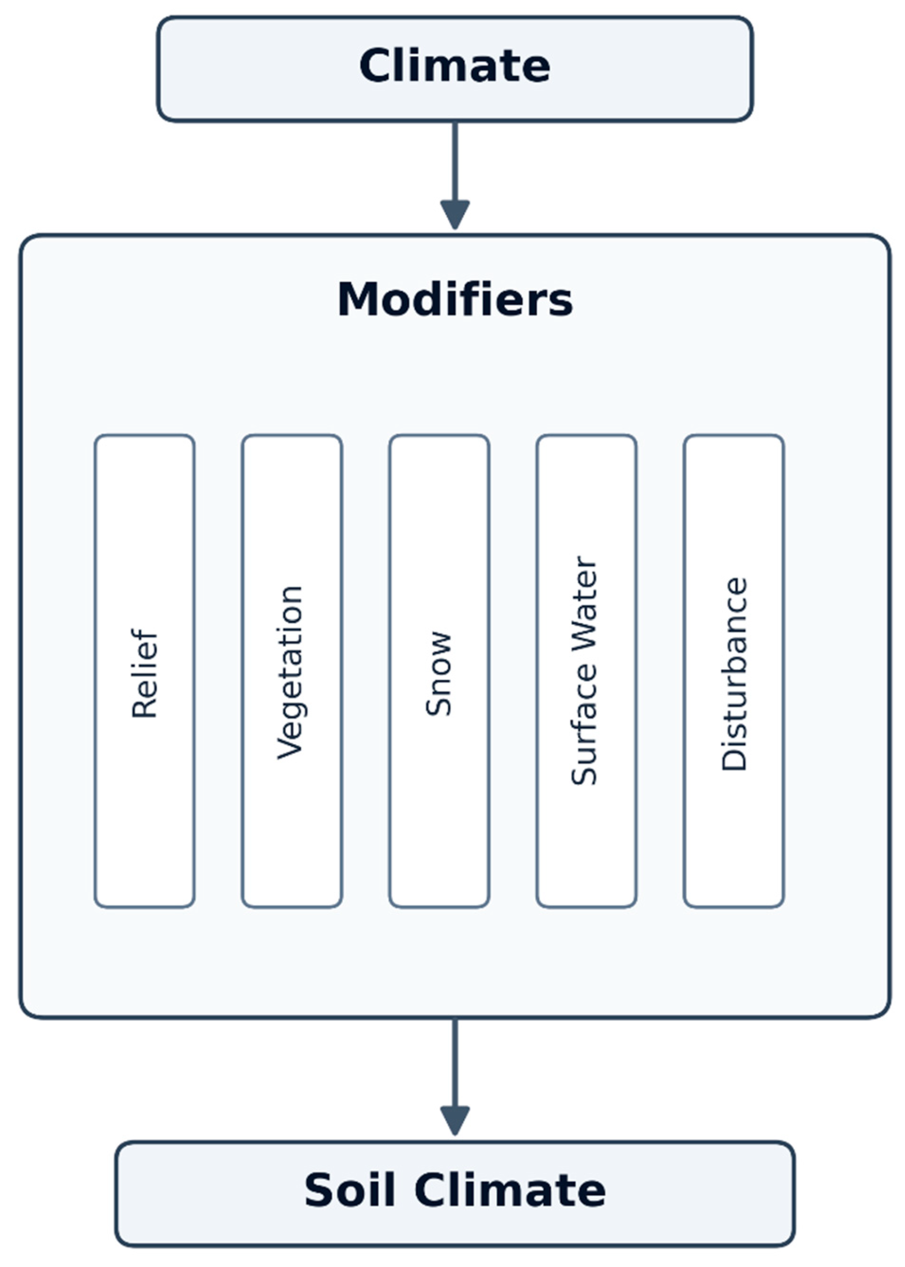
Figure 2.
Types of ground-ice distribution with their relation to thermokarst (modified from Shur and Osterkamp, 2007).
Figure 2.
Types of ground-ice distribution with their relation to thermokarst (modified from Shur and Osterkamp, 2007).
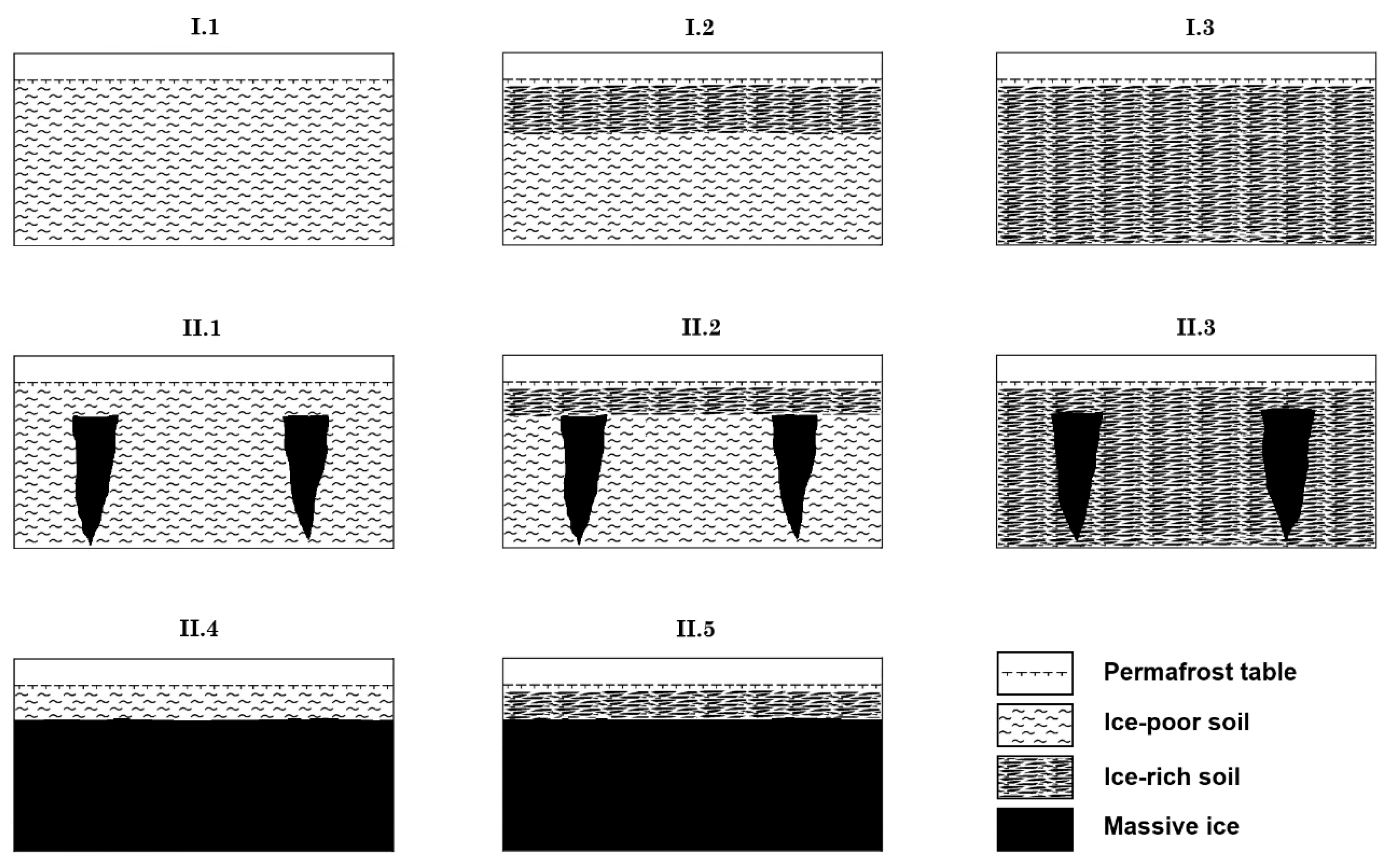
Figure 3.
Ratio of ultimate settlement in relation to time and thaw strain (δ).
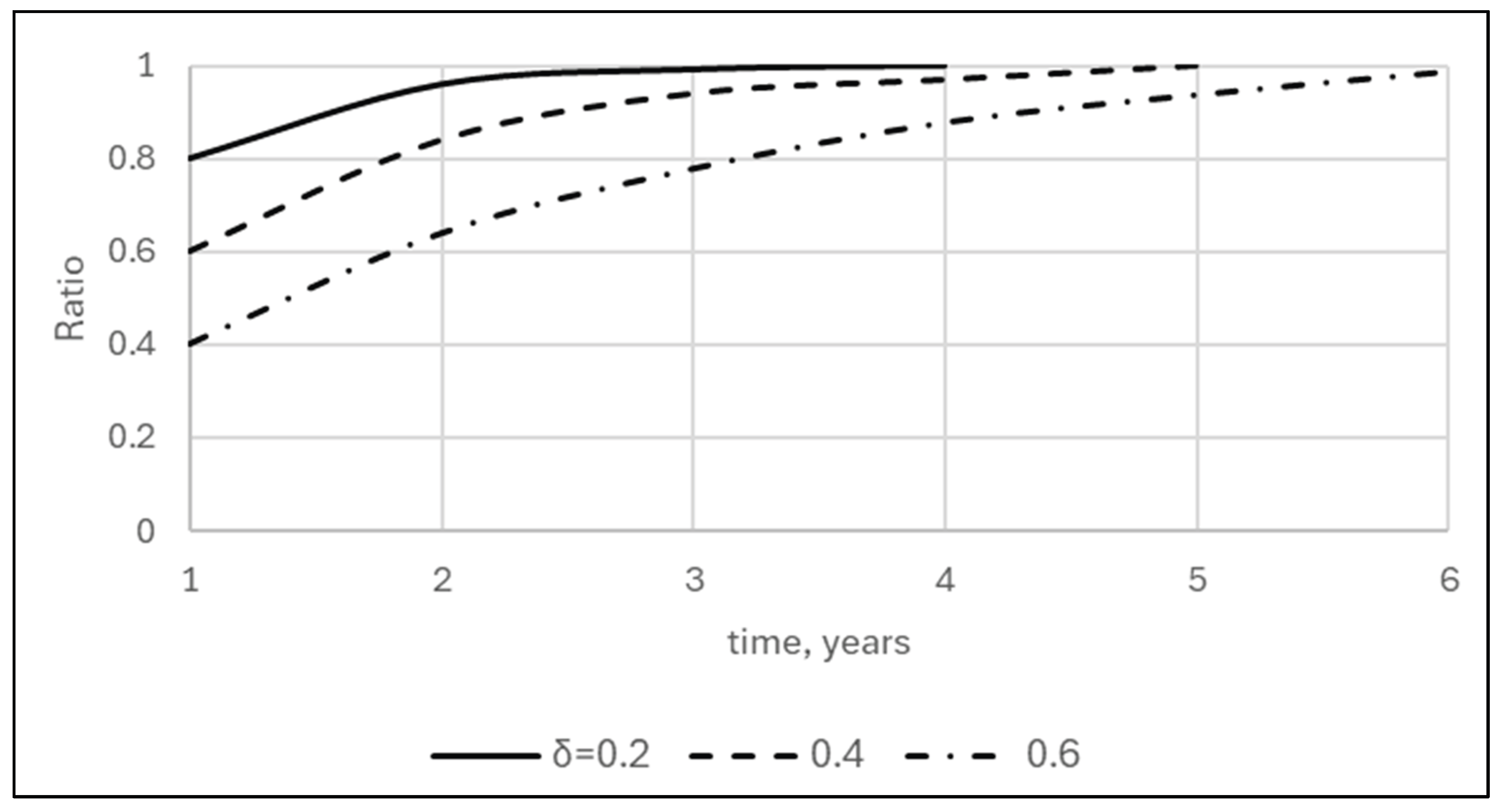
Figure 4.
Average settlement of thawing permafrost to a depth of 3 m as a function of size of ice-wedge polygons (10, 14, and 18 m), width of ice wedges, and thaw strain of soil. Thaw strain of 0.5 corresponds to mineral soil with gravimetric moisture content of >120% (Shur, 1988a; Kanevskiy et al., 2012).
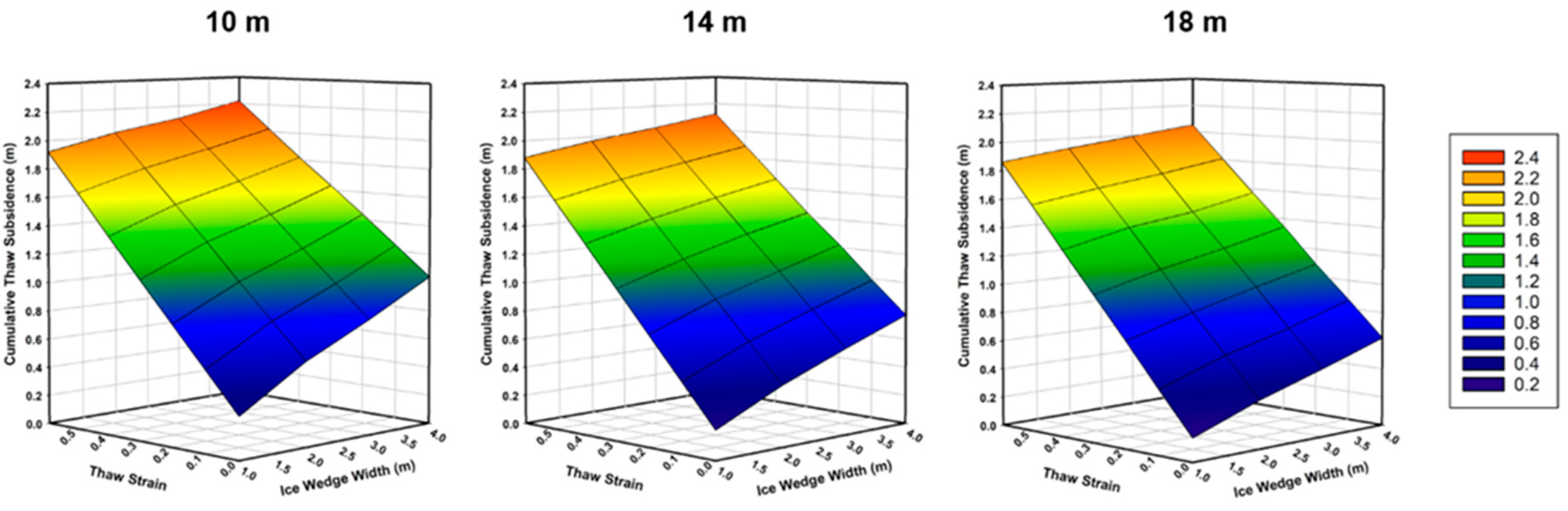
Figure 5.
Examples of Google Earth satellite images illustrating ice-wedge thermokarst in Siberia and Alaska.
Figure 5.
Examples of Google Earth satellite images illustrating ice-wedge thermokarst in Siberia and Alaska.
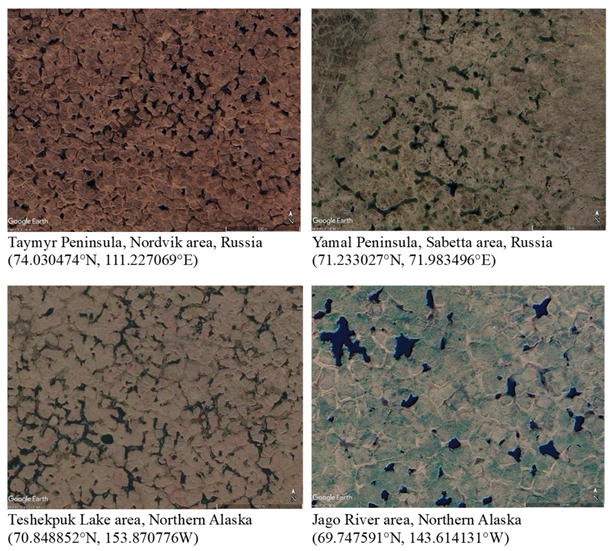
Figure 6.
Topographic profiles of ice-wedge degradation transect at Prudhoe Bay (70.2288, -148.41866), Alaska, showing the elevational relationships between the ground surface and permafrost table in 2012-2019. Note that most of the ice wedges that experienced significant degradation before 2012 (indicated by deep troughs) have become stable, while some initially stable ice wedges have been degrading since 2012.
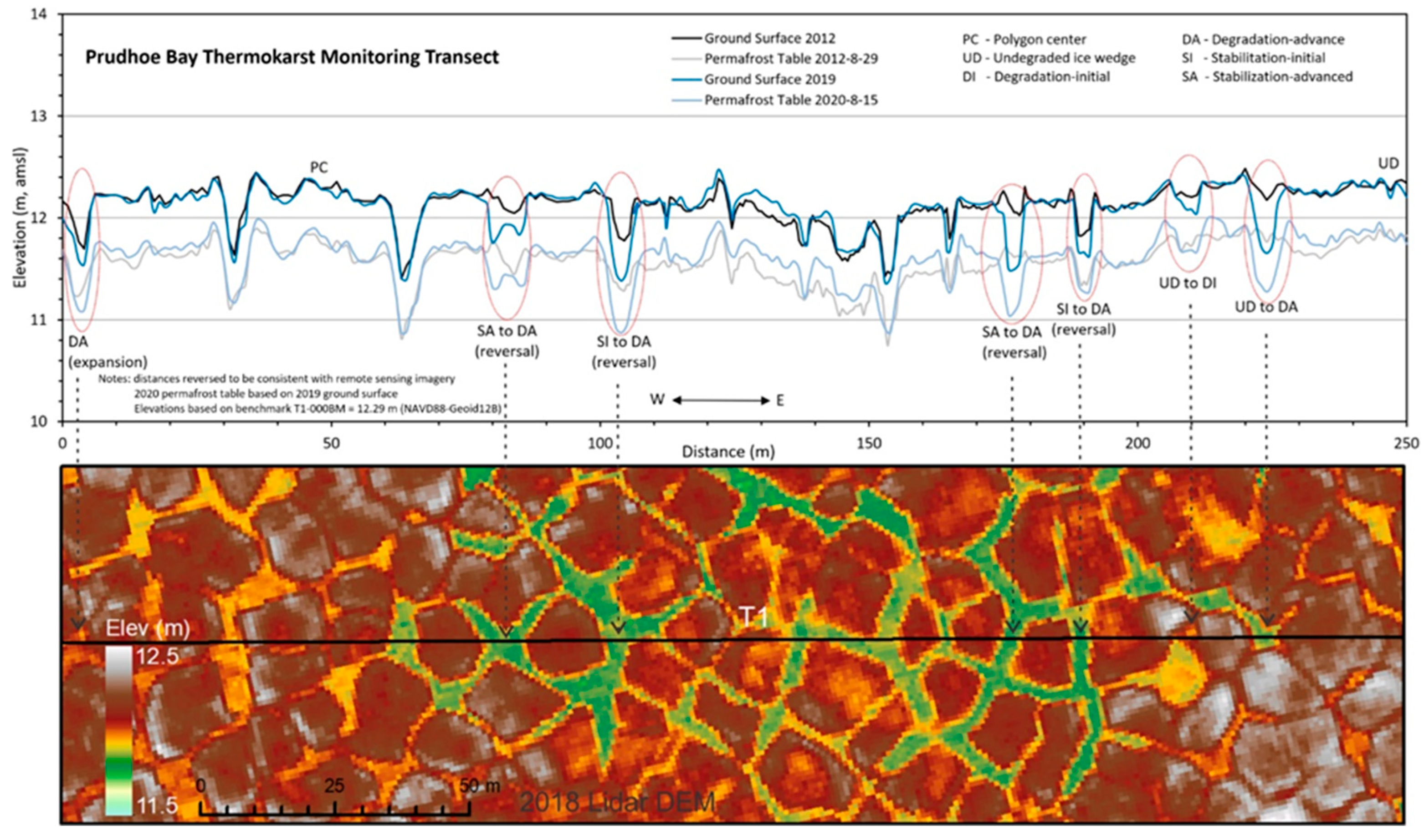
Figure 7.
Satellite images showing the slow progression of the ice-wedge thermokarst over ~60-year period, resulting in the development of thermokarst lakes, Taymyr Peninsula, Khatanga area, Russia (72.008477°N, 102.431725°E).
Figure 7.
Satellite images showing the slow progression of the ice-wedge thermokarst over ~60-year period, resulting in the development of thermokarst lakes, Taymyr Peninsula, Khatanga area, Russia (72.008477°N, 102.431725°E).
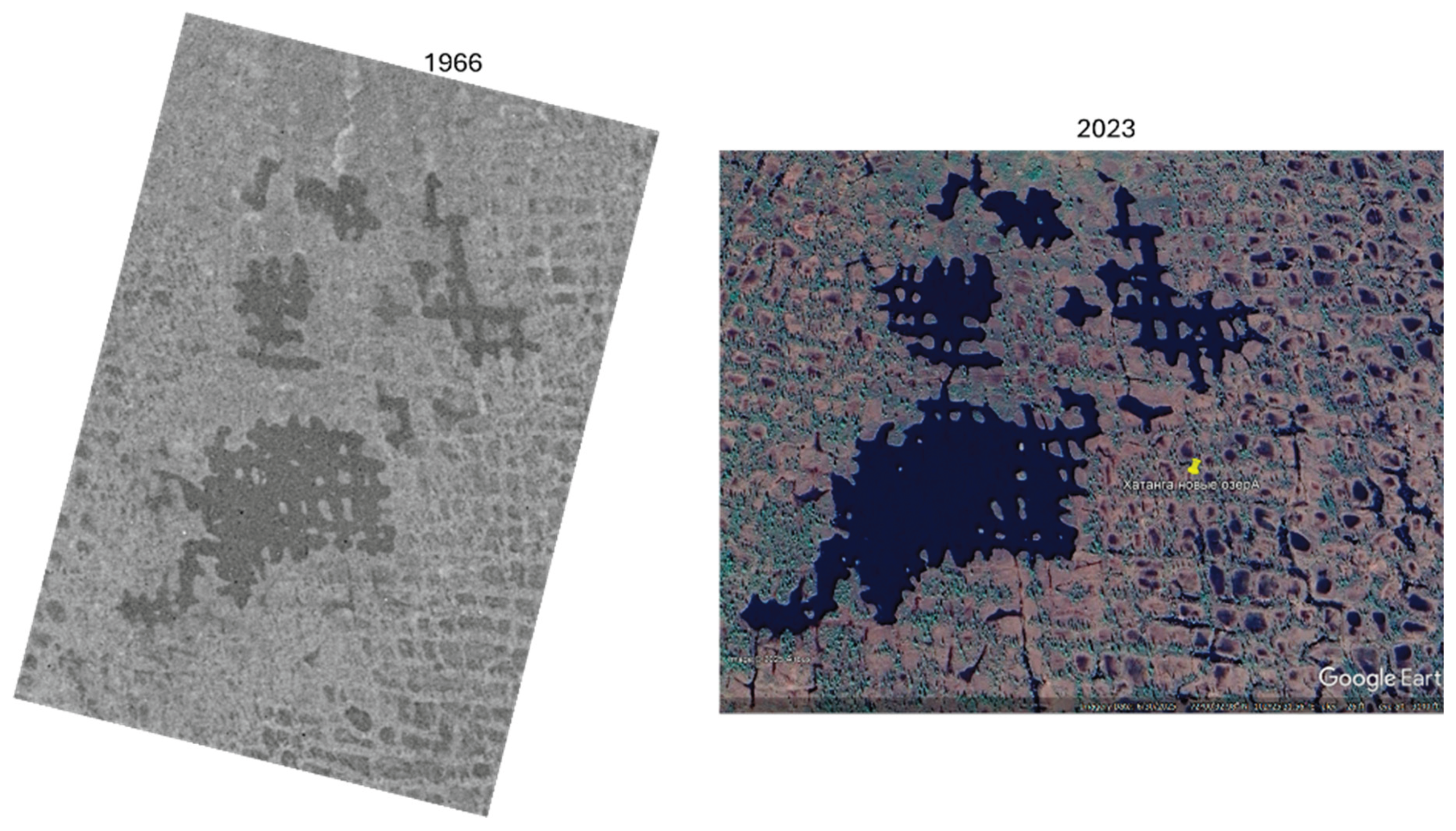
Figure 8.
Thermokarst mounds in (Left) Churapcha, Central Yakutia (courtesy Dr. A.N. Fedorov) and (Right) Interior Alaska (partially drained Horseshoe Lake near Fairbanks).
Figure 8.
Thermokarst mounds in (Left) Churapcha, Central Yakutia (courtesy Dr. A.N. Fedorov) and (Right) Interior Alaska (partially drained Horseshoe Lake near Fairbanks).
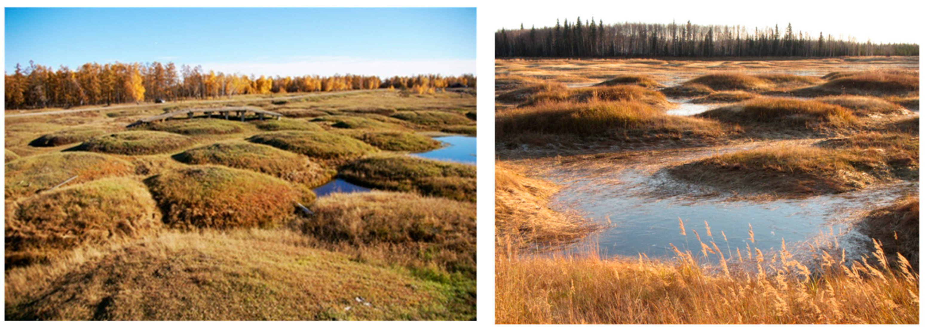
Figure 9.
Large, water-filled thermokarst troughs on an abandoned floodplain at Bylot Island, Canadian Arctic Archipelago: (Left) Field photograph; note the surface cracking along the rims, indicating slumping of thawed soil into the troughs; (Right) Google Earth satellite image of the same area (73.155257° N, -79.986804° W).
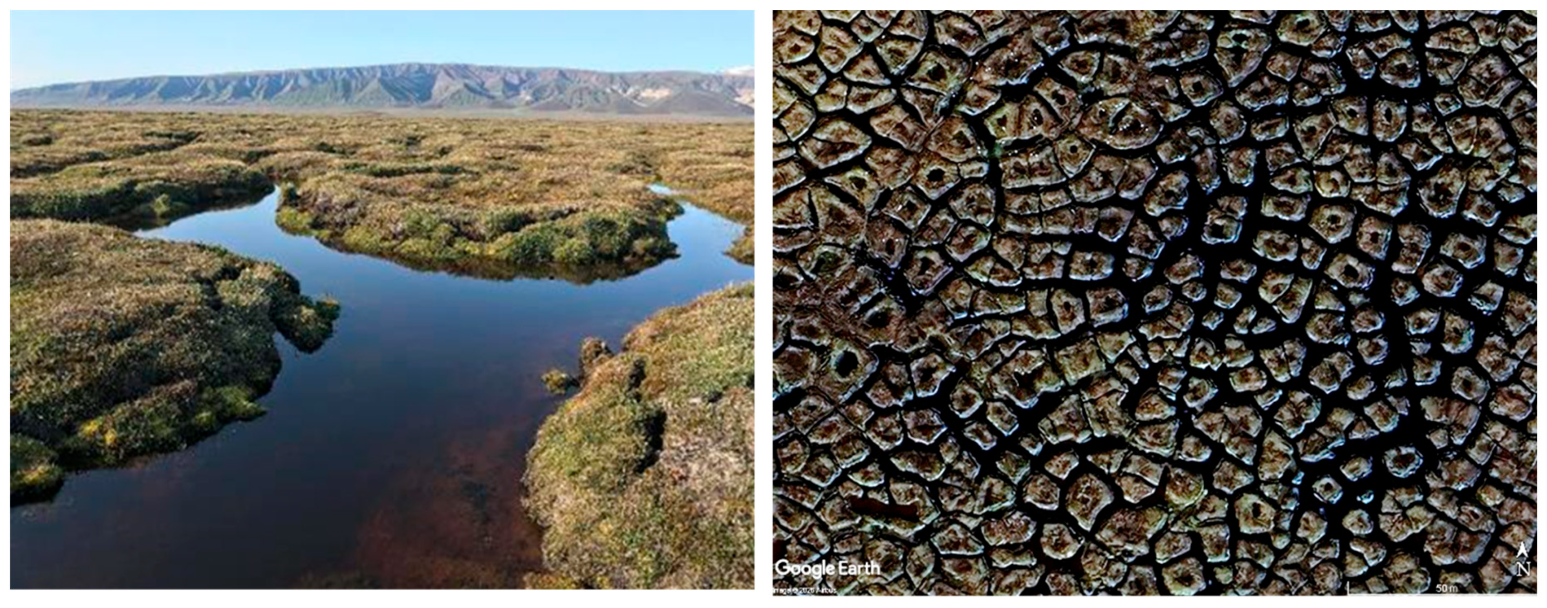
Figure 10.
Google Earth satellite images and aerial photographs illustrating the formation of thermokarst ponds resulting from ice-wedge degradation and subsequent lateral erosion of the central parts of polygons in Central Yakutia and Alaska.
Figure 10.
Google Earth satellite images and aerial photographs illustrating the formation of thermokarst ponds resulting from ice-wedge degradation and subsequent lateral erosion of the central parts of polygons in Central Yakutia and Alaska.
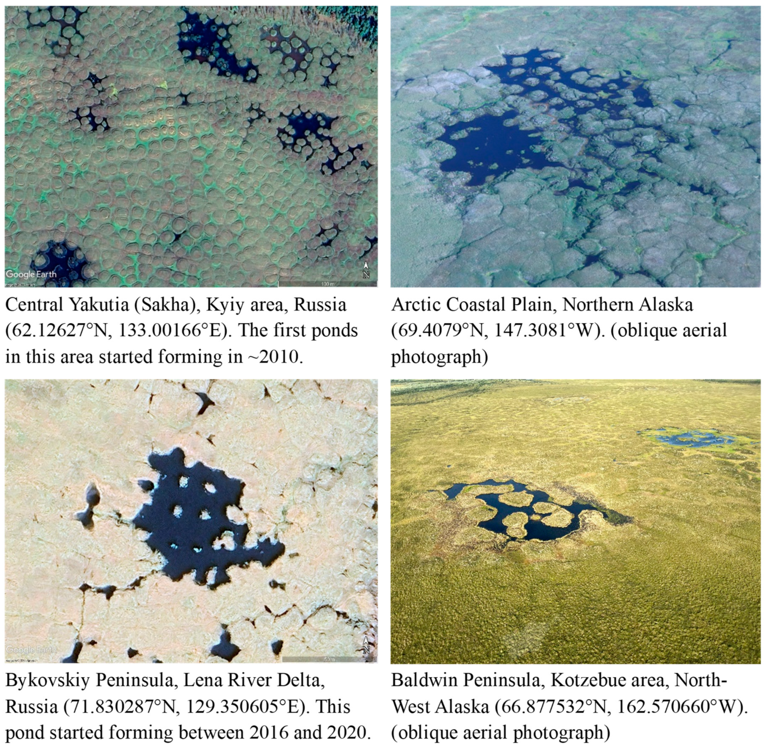
Figure 11.
A time-series of historical aerial photographs and satellite imagery showing progressive development of ice-wedge thermokarst near Buckland, north-west Alaska (65.973° N, 161.183° W). Top panel: Imagery from 1949, 1974, 2004, and 2020. Middle panel: Differentiation of polygon centers (light green), vegetated thermokarst troughs (dark green), and water-filled troughs (blue green). Bottom panel: Enlargement of the central area (red box in the middle panel).
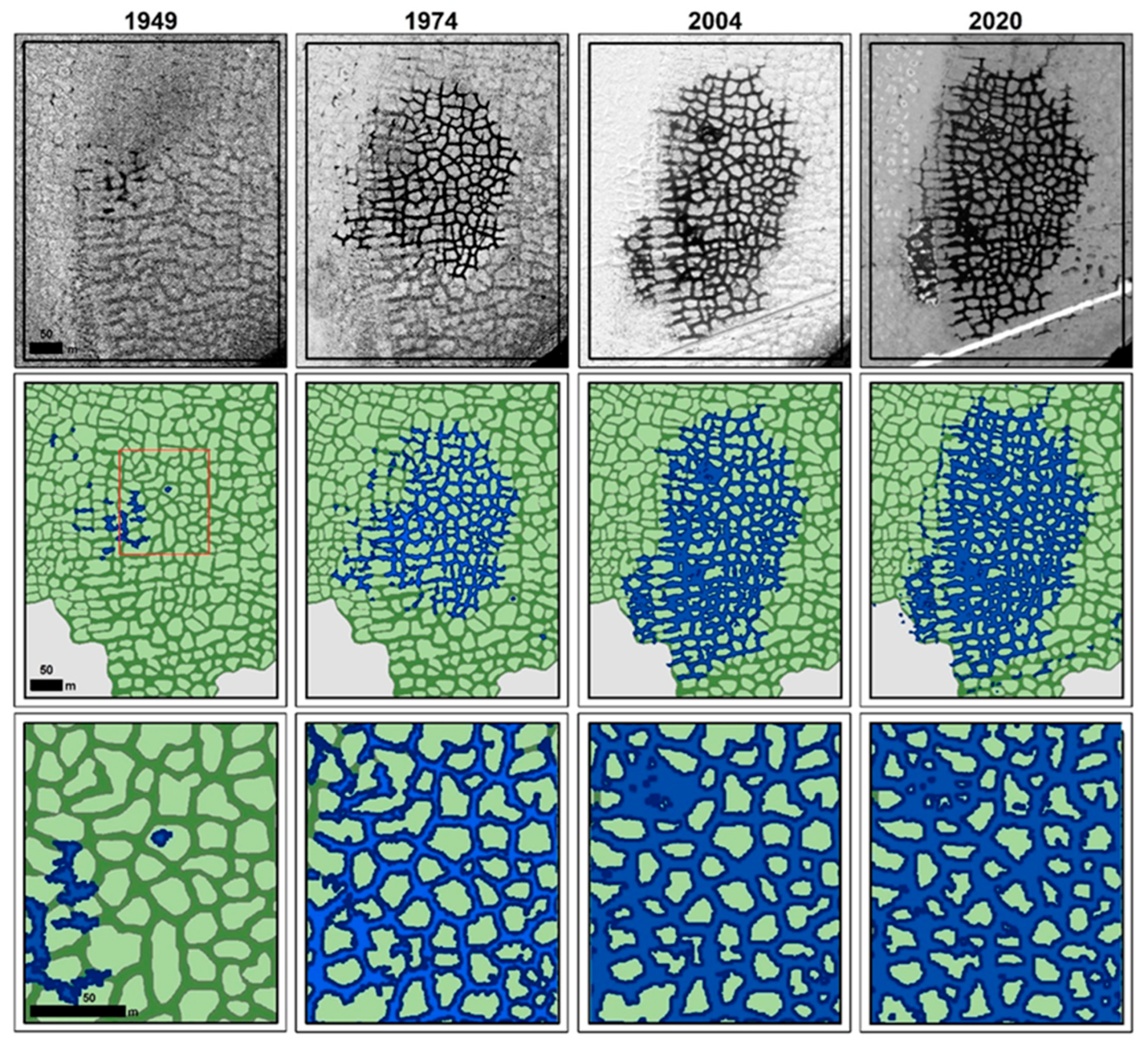
Figure 12.
A time-series of satellite imagery showing progressive development of ice-wedge thermokarst near the Spine Road (Prudhoe Bay area, northern Alaska, 70.245° N, 148.568° W). Top panel: imagery from 2000, 2006, 2012, and 2018. Bottom panel: Differentiation of polygon centers (light green), vegetated thermokarst troughs (dark green), and water-filled troughs (blue green). Lateral expansion of water-filled ice-wedge troughs has significantly intensified after the construction of the gravel pad in 2014.
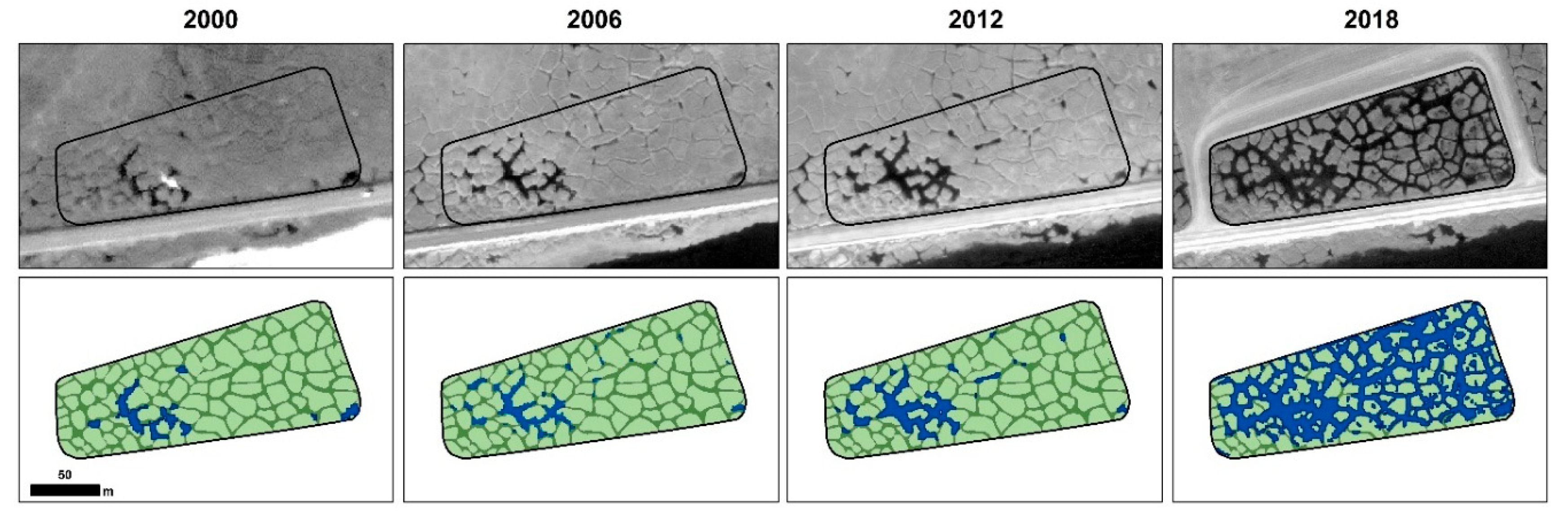
Figure 13.
Change in areal extent (m2/yr) of new thermokarst features (areas of water-filled troughs, pits, and ponds) over three time periods associated with ice-wedge thermokarst (areas of submerged water-filled troughs, dark green) and thermal erosion of polygon centers (areas of submerged parts of former polygon centers, light green) at Buckland (left) and Prudhoe Bay (right) study areas, see Figure 11 and Figure 12, respectively.
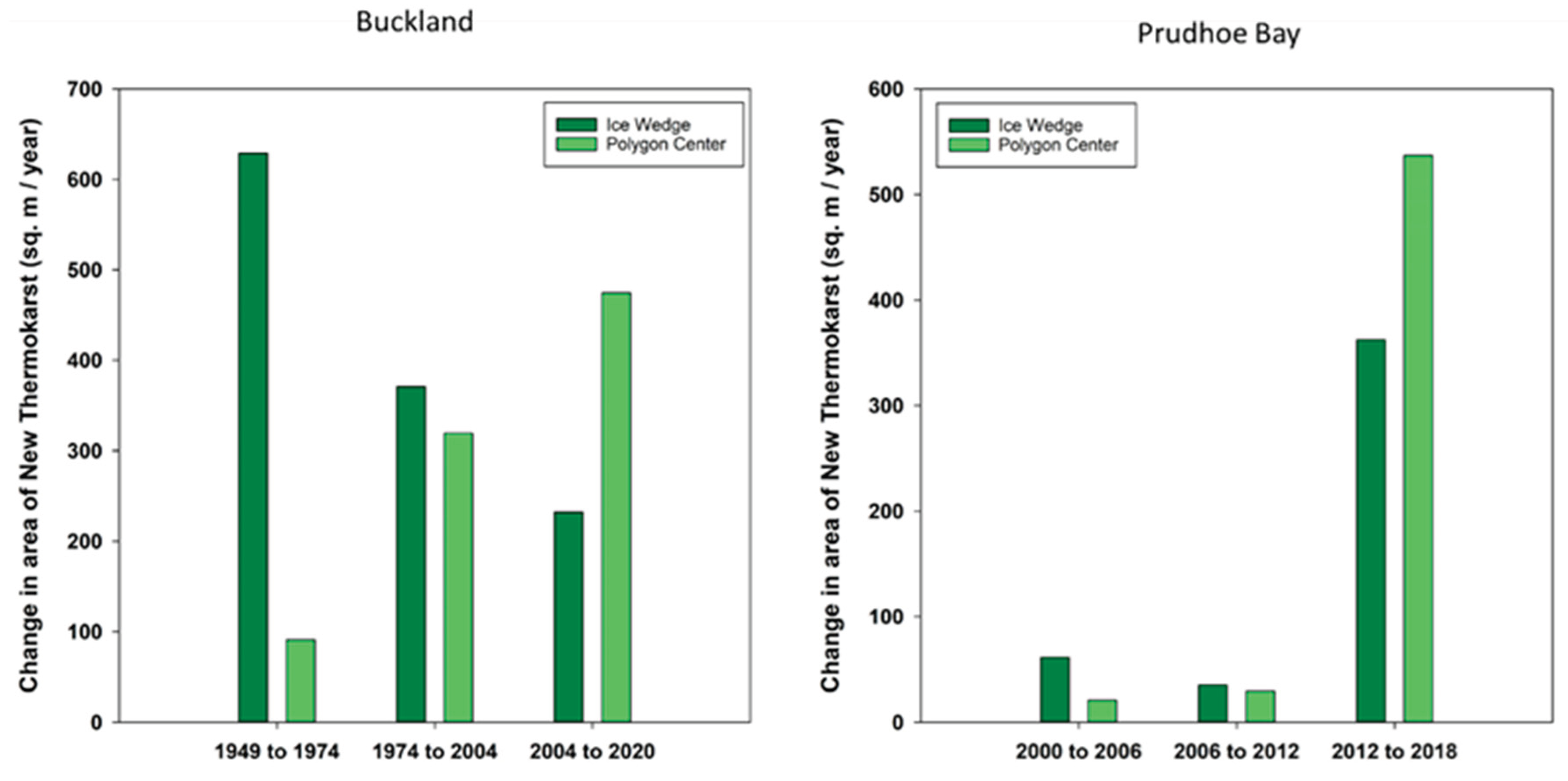
Figure 14.
Conceptual model of the role of ice-wedge thermokarst and thermal erosion of the central parts of polygons in the formation of thermokarst lakes. The schematic shows loss of wedge ice, destruction of surface vegetation, impoundment of water, lateral degradation of the central parts of polygons, and accumulation of reworked soils in the troughs and thermokarst ponds, leading to the formation of veneering structures with sub-aquatic ice-wedge pseudomorphs.
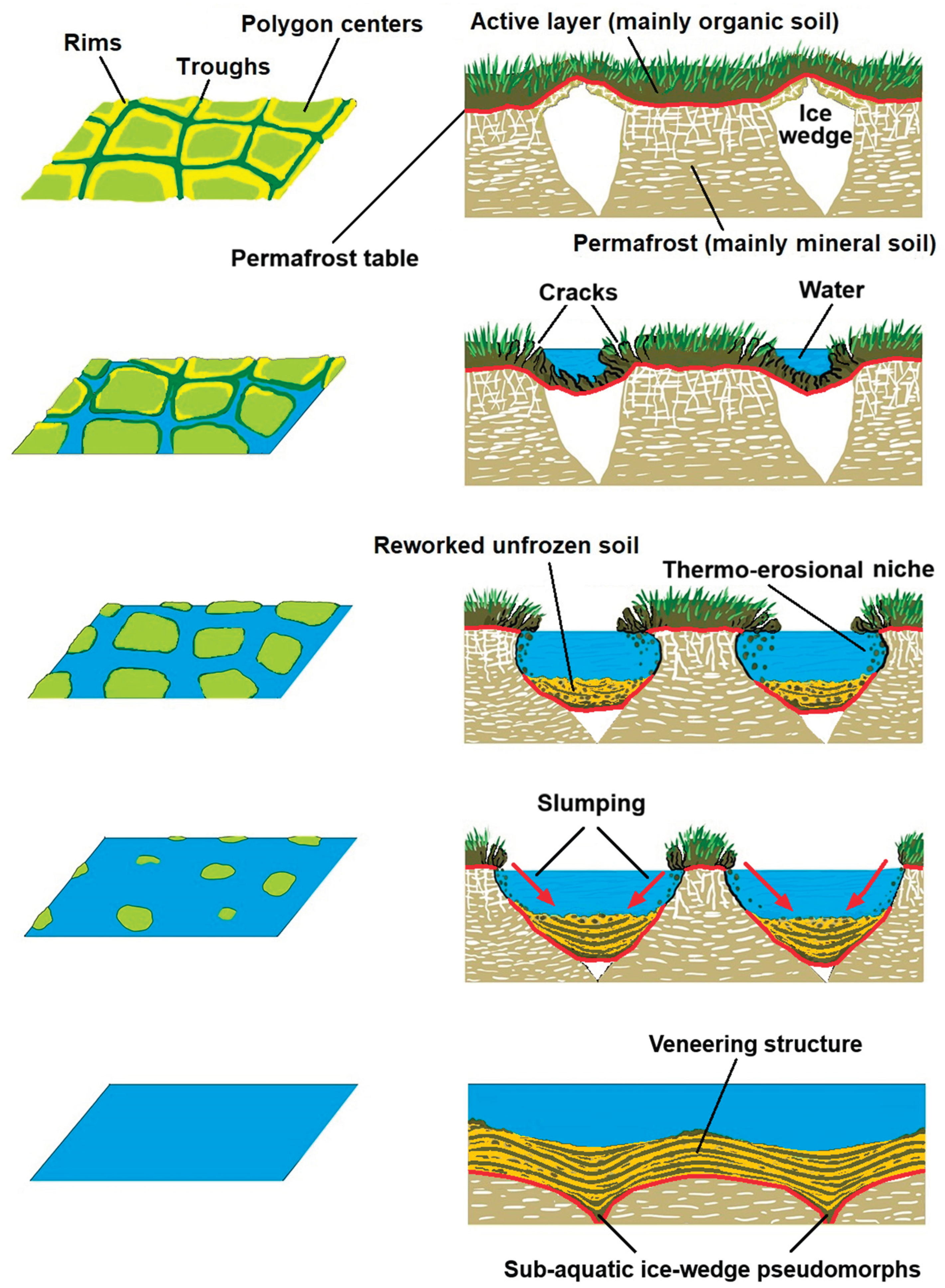
Figure 15.
Veneering structures with ice-wedge pseudomorphs. Top: Schematic of Quaternary deposits, Bol’shoy Lyakhovskiy Island (modified from Romanovskii, 1958b); Bottom: Veneering permafrost structures, Bol’shoy Lyakhovskiy Island, south coast (modified from Romanovskii, 1977).
Figure 15.
Veneering structures with ice-wedge pseudomorphs. Top: Schematic of Quaternary deposits, Bol’shoy Lyakhovskiy Island (modified from Romanovskii, 1958b); Bottom: Veneering permafrost structures, Bol’shoy Lyakhovskiy Island, south coast (modified from Romanovskii, 1977).
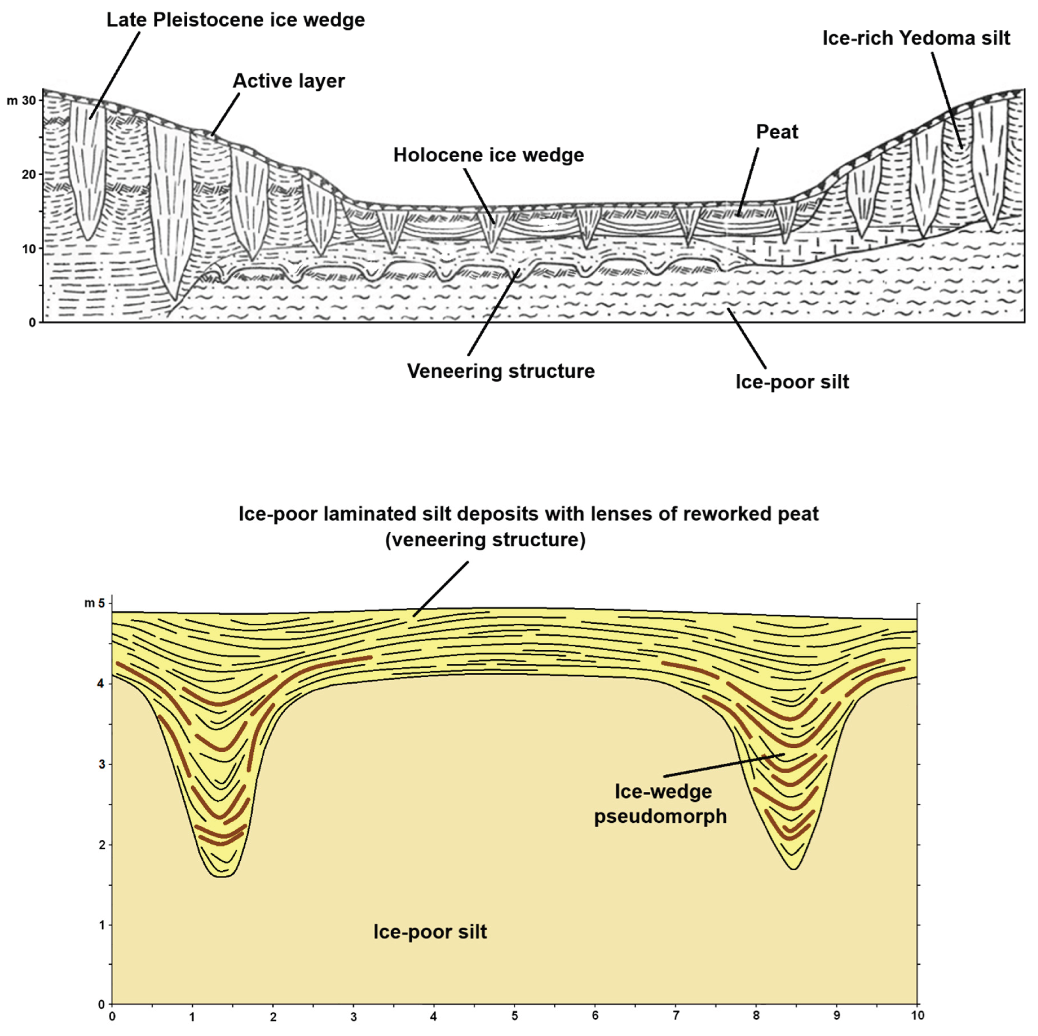
Figure 16.
Conceptual 3-D model showing the stages of self-destruction of ice wedges within interconnected lowland, hillslope, and upland ice-wedge systems. This process includes: (A-D) expanding ice-wedge degradation on lowlands; (B-C) linear uphill propagation of ice-wedge degradation on slopes; (C-E) dendritic degradation of ice wedges on uplands triggered by linear uphill erosion and development of perched thaw lakes; and (E-F) drainage of perched thaw lakes caused by downhill thermal erosion along hillslope ice wedges.
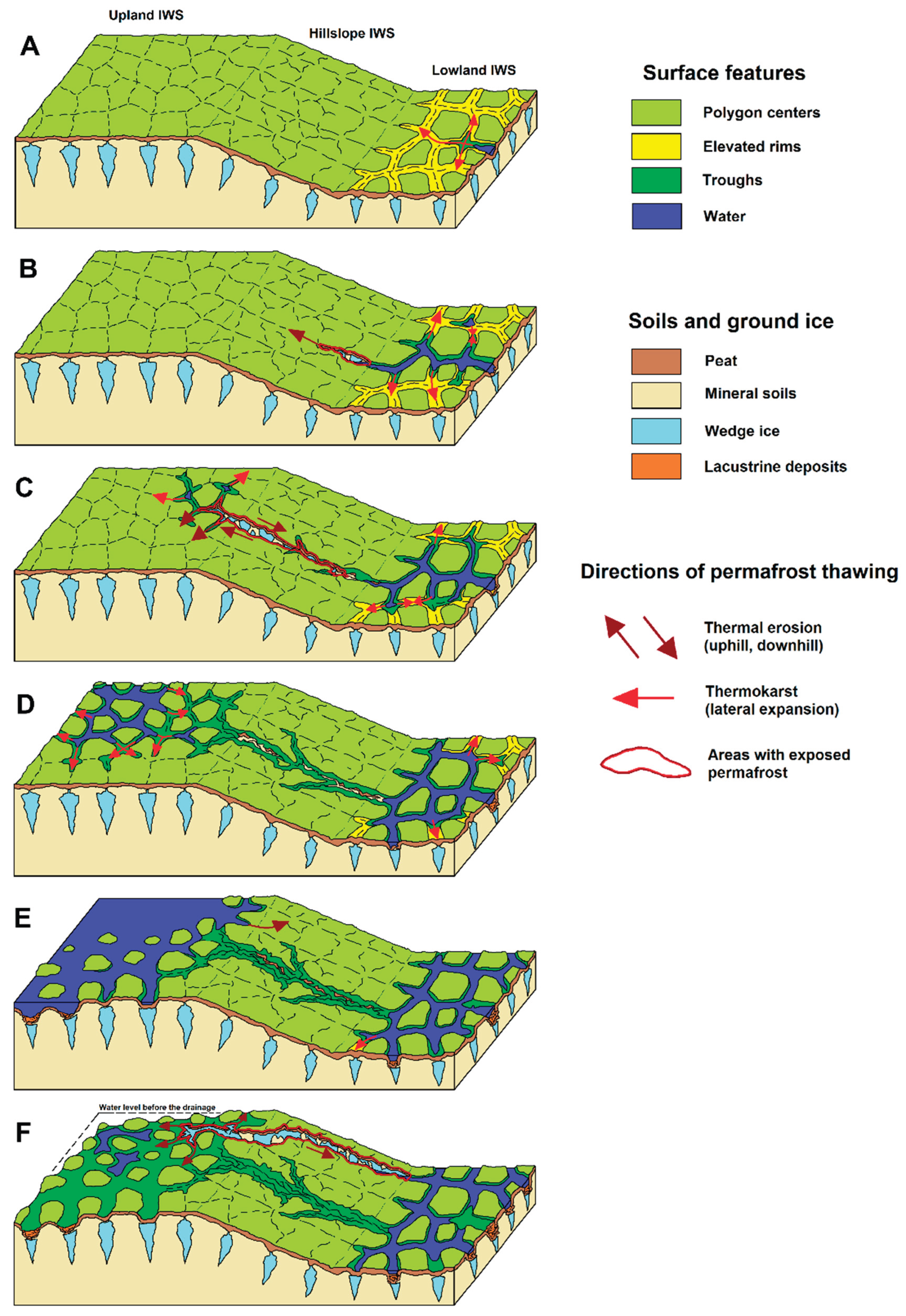
Figure 17.
Linear uphill erosion along the hillslope ice-wedge system leading to the development of a thaw pond through dendritic degradation in the upland ice-wedge system (Kivalina area, northwest Alaska; 67.9734°N; 164.3256°W).
Figure 17.
Linear uphill erosion along the hillslope ice-wedge system leading to the development of a thaw pond through dendritic degradation in the upland ice-wedge system (Kivalina area, northwest Alaska; 67.9734°N; 164.3256°W).
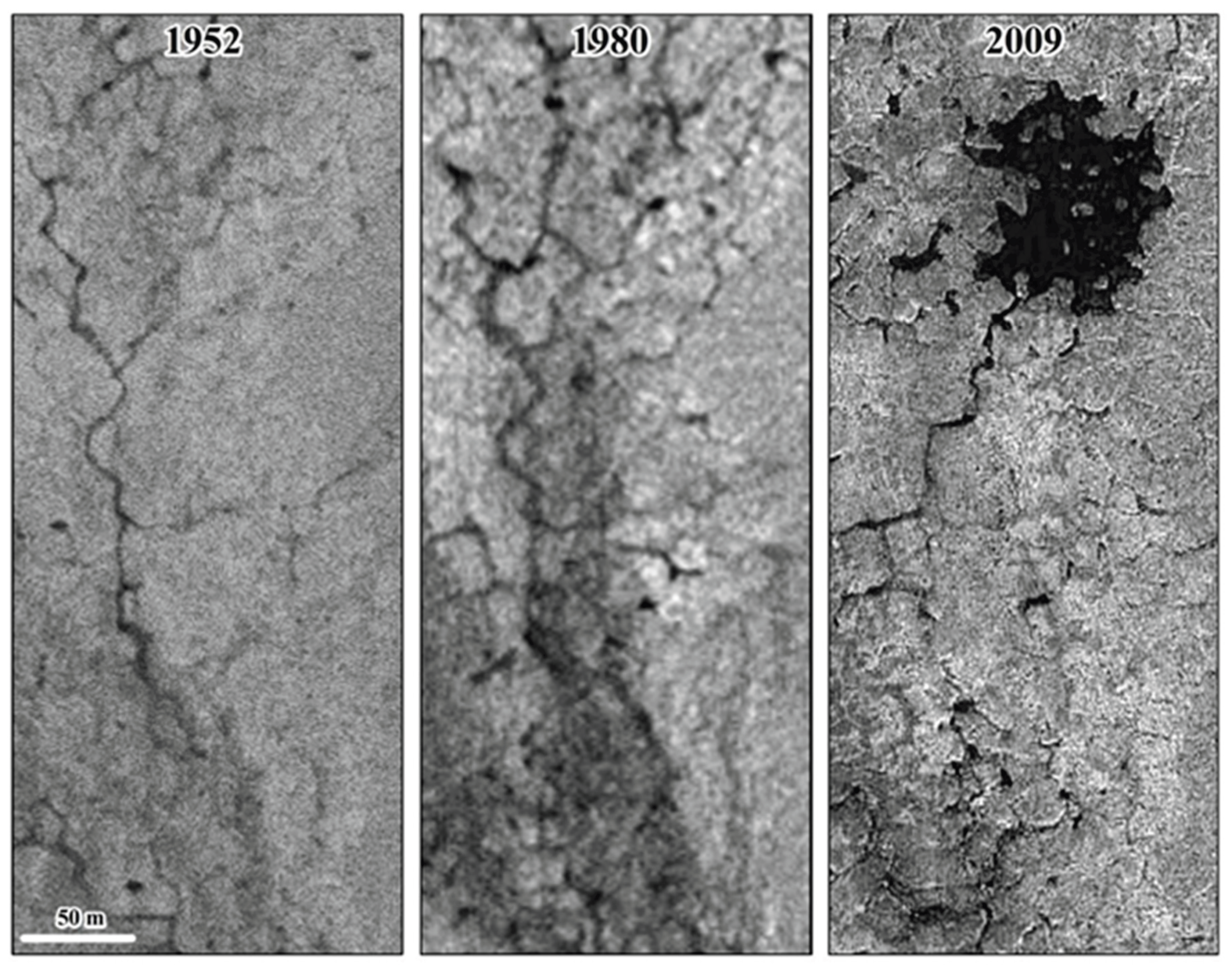
Disclaimer/Publisher’s Note: The statements, opinions and data contained in all publications are solely those of the individual author(s) and contributor(s) and not of MDPI and/or the editor(s). MDPI and/or the editor(s) disclaim responsibility for any injury to people or property resulting from any ideas, methods, instructions or products referred to in the content. |
© 2026 by the authors. Licensee MDPI, Basel, Switzerland. This article is an open access article distributed under the terms and conditions of the Creative Commons Attribution (CC BY) license (http://creativecommons.org/licenses/by/4.0/).
Copyright: This open access article is published under a Creative Commons CC BY 4.0 license, which permit the free download, distribution, and reuse, provided that the author and preprint are cited in any reuse.