

Submitted:
26 September 2026
Posted:
29 September 2026
You are already at the latest version
Abstract
The GEOGloWS ECMWF Streamflow Service represents a paradigm shift in global hydrological forecasting by implementing Hydrology as a Service (HaaS), providing operational river discharge predictions for every river reach worldwide. This review examines the technical architecture, validation performance, and diverse applications of the GEOGloWS system, which centralizes computational resources at the European Centre for Medium-Range Weather Forecasts (ECMWF) to deliver 15-day ensemble streamflow forecasts and historical simulations since 1979 through open web services. The system addresses critical gaps in hydrological data availability, particularly benefiting hydromet services, local governments, and NGOs in data-scarce regions. Regional validation studies across Australia, Brazil, Colombia, Dominican Republic, Peru, Bhutan, and the Nile Basin demonstrate the system's global applicability, while bias correction methodologies significantly improve forecast accuracy. Applications span flood early warning systems, water resource management, transboundary river monitoring, and decision support for emergency management. Despite challenges including bias in ungauged basins, computational constraints, and the need for local calibration, GEOGloWS establishes a foundation for democratizing access to hydrological information. Future directions include enhanced spatial resolution, improved bias correction techniques, integration with Earth observation data, and expanded capacity building for operational implementation in developing regions.
Keywords:
GEOGloWS
; ECMWF
; global hydrological modeling
; Hydrology as a Service
; streamflow forecasting
; flood early warning
; bias correction
; operational hydrology
; water resources management
; decision support systems
1. Introduction
Global hydrological forecasting has emerged as a critical capability for addressing water-related challenges in an era of increasing climate variability, population growth, and urbanization. The GEOGloWS (Group on Earth Observations Global Water Sustainability) ECMWF Streamflow Service represents a transformative approach to operational river forecasting by implementing a Hydrology as a Service (HaaS) model that provides streamflow predictions for every river reach on Earth [12]. This innovative system centralizes computational resources and hydrological expertise at the European Centre for Medium-Range Weather Forecasts (ECMWF), delivering 15-day ensemble forecasts and historical simulations through open web services accessible to users worldwide [12].
The fundamental innovation of GEOGloWS lies in its service-oriented architecture, which addresses a persistent challenge in operational hydrology: the vast majority of the world's rivers lack gauging stations or operational forecasting systems. By providing global coverage through a centralized modeling infrastructure, GEOGloWS democratizes access to hydrological information, particularly benefiting hydromet services, local governments, and NGOs in data-scarce regions [1,24]. This approach contrasts sharply with traditional paradigms that require each institution to develop and maintain independent modeling capabilities.
The system builds upon decades of advances in global hydrological modeling, numerical weather prediction, and web service technologies. It leverages ECMWF's operational meteorological forecasts and reanalysis products, routing runoff through a high-resolution global river network to produce discharge predictions at approximately 1 million river reaches worldwide [12]. The resulting forecasts are delivered through standardized web services, enabling integration into local decision support systems, early warning platforms, and water management applications [9,24].
This review synthesizes the current state of knowledge regarding the GEOGloWS system, examining its technical foundations, validation performance across diverse geographic regions, and applications for operational water management. We analyze how the HaaS paradigm addresses traditional barriers to hydrological forecasting, evaluate the system's strengths and limitations based on regional case studies, and identify future directions for enhancing global hydrological services. The review is structured to serve both technical practitioners seeking to implement GEOGloWS in operational settings and policymakers evaluating the potential of global hydrological services for water security and disaster risk reduction.
2. Background and Motivation for Global Hydrological Forecasting
The need for global hydrological forecasting stems from fundamental gaps in observational infrastructure and forecasting capabilities across much of the world. Despite water-related disasters accounting for a substantial proportion of natural disaster impacts, operational river forecasting systems exist for only a small fraction of the world's rivers [28]. This disparity is particularly acute in developing regions, where limited financial resources, technical capacity, and institutional frameworks constrain the development of local hydrological services [24].
Traditional approaches to operational river forecasting require significant investments in gauging networks, computational infrastructure, hydrological expertise, and model development [29]. Each river basin or national agency must independently establish and maintain these capabilities, creating substantial barriers to entry. The result is a global landscape where high-income countries with well-developed hydromet services coexist with vast regions lacking basic streamflow information [51]. This inequality in hydrological information access has profound implications for flood preparedness, water resource management, and climate adaptation [45].
The emergence of global hydrological models over the past two decades has created new opportunities to address these gaps. Advances in satellite remote sensing, global datasets for topography and land surface characteristics, and numerical weather prediction have enabled the development of continental and global-scale hydrological modeling systems [28,31]. Systems such as the Global Flood Awareness System (GloFAS) demonstrated the feasibility of providing flood forecasts at global scales, coupling meteorological forecasts with hydrological models to generate river discharge predictions [21,27].
The GEOGloWS initiative emerged from recognition that a service-oriented approach could overcome these barriers by centralizing computational resources while distributing access through web services [12]. This model draws inspiration from successful implementations in numerical weather prediction, where centralized facilities like ECMWF provide forecast products to national meteorological services worldwide [21]. By applying this paradigm to hydrology, GEOGloWS aims to provide a global public good: freely accessible streamflow forecasts that can be localized and integrated into national and local decision-making systems [3,24].
The motivation for this approach extends beyond technical efficiency to address fundamental equity concerns in water information access. Hydromet services in developing countries often lack the resources to develop sophisticated forecasting systems, yet face disproportionate impacts from floods and water scarcity [40,45]. By providing a baseline global forecasting capability, GEOGloWS enables these services to focus resources on local calibration, validation, and integration with decision support systems rather than building modeling infrastructure from scratch [1,6].
The system also addresses the challenge of ungauged basins, where lack of observational data has traditionally precluded operational forecasting [17]. While GEOGloWS forecasts require local calibration for optimal accuracy, they provide a starting point for hydrological information even in completely ungauged catchments [18]. This capability is particularly valuable for minor tributaries, transboundary rivers, and remote regions where establishing gauging networks is impractical [17,22].
3. GEOGloWS Architecture and Technical Foundations
3.1. System Architecture and ECMWF Integration
The GEOGloWS ECMWF Streamflow Service is built on a centralized computing architecture that leverages ECMWF's operational infrastructure to generate global streamflow forecasts [12]. This architecture represents a fundamental departure from distributed hydrological modeling approaches, concentrating computational resources and technical expertise at a single facility while distributing access through standardized web services [53].
The system operates on ECMWF's high-performance computing infrastructure, processing meteorological forecast data through a global hydrological model to produce discharge predictions for approximately 1 million river reaches worldwide [12]. The computational workflow begins with ECMWF's Integrated Forecasting System (IFS), which generates ensemble weather forecasts including precipitation and temperature fields [2]. These meteorological inputs drive the hydrological model, which simulates runoff generation and routes water through the global river network to produce streamflow forecasts [25].
The system generates two primary products: 15-day ensemble streamflow forecasts updated daily, and a historical simulation extending from January 1979 to the present [12]. The ensemble forecasts provide probabilistic information about future streamflow conditions, with 52 ensemble members representing uncertainty in meteorological predictions [8]. The historical simulation, driven by ERA5 reanalysis data, provides a climatological context for interpreting forecasts and enables statistical analysis of hydrological extremes [1,18].
3.2. Hydrological Model Components
The hydrological modeling framework employed by GEOGloWS consists of two primary components: a land surface model for runoff generation and a river routing model for streamflow propagation [12]. The runoff generation component processes ECMWF meteorological forecasts to estimate surface and subsurface runoff across the global land surface [25]. This component accounts for precipitation, evapotranspiration, soil moisture dynamics, and snowmelt processes to determine the volume of water entering the river network [2].
The river routing component employs the RAPID (Routing Application for Parallel computatIon of Discharge) model, which propagates runoff through a high-resolution representation of the global river network [25]. The river network is derived from the HydroSHEDS dataset, providing topologically connected stream reaches at approximately 1-km resolution [12]. RAPID uses a matrix-based routing approach that enables efficient computation of streamflow at all river reaches simultaneously, making global-scale routing computationally feasible [25]. Model parameters including channel geometry, roughness, and flow velocity are estimated from global datasets and empirical relationships [18].
3.3. Data Services and Web Infrastructure
The GEOGloWS system exposes streamflow forecasts and historical simulations through a comprehensive suite of web services designed for both human users and programmatic access [9,12]. The service architecture follows RESTful API principles, providing standardized endpoints for retrieving forecast data, historical simulations, and statistical summaries for any river reach in the global network [53].
The primary data services include time series retrieval for individual river reaches, spatial queries for identifying reaches within geographic regions, and statistical analysis tools for computing return periods and exceedance probabilities [9]. These services return data in standard formats including JSON and CSV, enabling integration with diverse client applications and programming environments [24]. A Python client package provides high-level functions for accessing GEOGloWS data, simplifying integration into scientific workflows and operational systems [17].
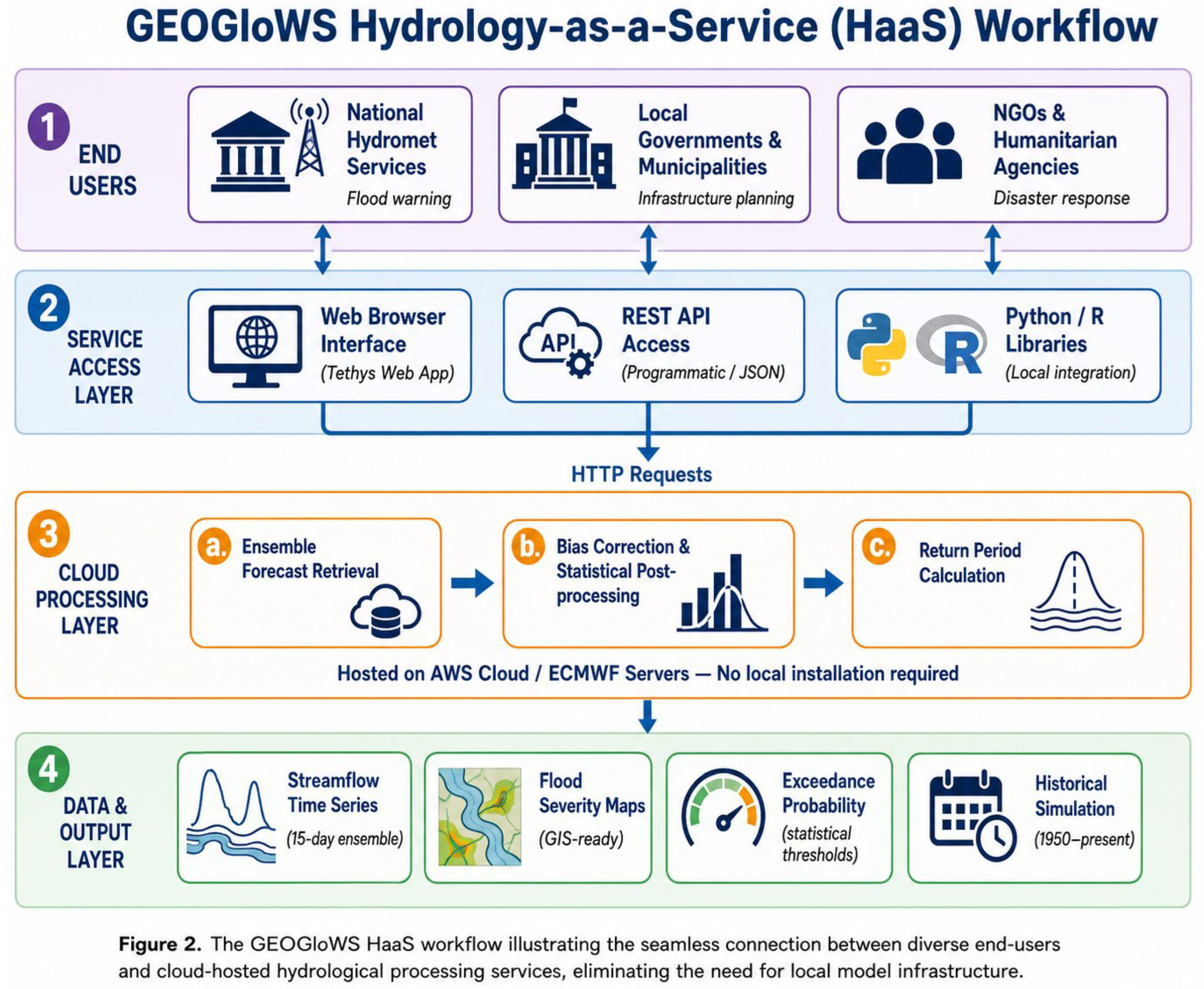
The web service architecture enables a distributed ecosystem of applications built on GEOGloWS data [24]. National hydromet services can integrate GEOGloWS forecasts into existing decision support systems, researchers can access data for model validation and hydrological analysis, and NGOs can develop early warning applications for vulnerable communities [1,32]. This service-oriented approach maximizes the value of the centralized modeling infrastructure by enabling diverse applications without requiring users to replicate the computational workflow [53].
4. Hydrology as a Service: Concept and Implementation
4.1. The HaaS Paradigm
Hydrology as a Service (HaaS) represents a fundamental shift in how hydrological information is produced and delivered, moving from distributed modeling efforts to centralized computation with distributed access [12,53]. This paradigm draws inspiration from successful implementations in other domains, particularly numerical weather prediction, where centralized facilities provide forecast products to users worldwide [21]. The core principle is to concentrate computational resources, technical expertise, and data management at specialized facilities while democratizing access through standardized web services [3].
The HaaS model addresses several persistent challenges in operational hydrology. First, it eliminates redundant modeling efforts, as multiple institutions no longer need to independently implement and maintain similar modeling systems [12]. Second, it reduces barriers to entry for organizations lacking computational infrastructure or hydrological modeling expertise [24]. Third, it enables consistent global coverage, ensuring that even ungauged and data-scarce regions have access to baseline hydrological information [17]. Fourth, it facilitates rapid dissemination of model improvements, as enhancements to the centralized system immediately benefit all users [18].
A critical aspect of the HaaS paradigm is the emphasis on localization and bias correction [1,18]. While the global model provides consistent coverage, local calibration using observed streamflow data significantly improves forecast accuracy [1]. The system therefore provides tools and methodologies for bias correction, enabling users to adapt global forecasts to local conditions [18]. This approach recognizes that a single global model cannot capture all local hydrological processes, but can provide a valuable starting point that users enhance with local knowledge and data [3].
4.2. Web Services and API Architecture
The technical implementation of HaaS in GEOGloWS relies on a comprehensive web services architecture that provides programmatic access to streamflow forecasts and historical simulations [9,53]. The API design follows RESTful principles, using HTTP requests to retrieve data for specific river reaches, geographic regions, or time periods [24]. This standardized approach enables integration with diverse programming languages, platforms, and applications without requiring specialized client software [17].
The core API endpoints provide access to several data products. The forecast endpoint returns 15-day ensemble streamflow predictions for a specified river reach, including all 52 ensemble members and statistical summaries [9]. The historical simulation endpoint provides daily streamflow values from 1979 to present, enabling analysis of long-term trends and climatological context [1]. Return period endpoints compute flood frequency statistics, identifying threshold discharges corresponding to 2-year, 5-year, 10-year, and higher return periods [8,16].
4.3. User Interface Applications
While the web services provide programmatic access for technical users, several user interface applications make GEOGloWS accessible to non-technical audiences [9,24]. The Hydroviewer application serves as the primary web-based interface, providing an interactive map for exploring streamflow forecasts worldwide [9]. Users can click on any river reach to view forecast hydrographs, historical simulations, and return period thresholds, making global hydrological information accessible through an intuitive visual interface [9].
The Historical Validation Tool (HVT) provides a specialized interface for bias correction and performance evaluation [1]. This application enables users to upload observed streamflow data, compute bias correction parameters, and evaluate model performance using standard metrics [1]. Case studies in Australia, Brazil, Colombia, Dominican Republic, and Peru demonstrate the effectiveness of this approach [1].
The Tethys Platform provides a framework for developing customized applications on top of GEOGloWS services [23,24]. This open-source platform enables organizations to create tailored interfaces for specific user communities, integrating GEOGloWS forecasts with local data sources, decision support tools, and visualization capabilities [24]. Recent developments include the Global Water Level Forecast System (GWLFS), which extends GEOGloWS capabilities by transforming discharge forecasts into water level predictions using satellite altimetry data from over 20,000 virtual stations [8,16].
5. Validation and Performance Evaluation
5.1. Global Performance Assessment
Comprehensive validation of the GEOGloWS system has been conducted at global scales using thousands of gauging stations worldwide [18]. A landmark study evaluated bias-corrected discharge simulations at 12,965 gauges globally, demonstrating that the SABER bias correction method successfully reduced mean error at 90% of gauges [18]. This global assessment provides confidence in the system's ability to represent hydrological conditions across diverse climatic and physiographic settings [18].
The validation approach employs standard hydrological performance metrics including Nash-Sutcliffe Efficiency (NSE), Kling-Gupta Efficiency (KGE), percent bias (PBIAS), and correlation coefficients [1,5]. Global analyses reveal systematic patterns in model performance, with better accuracy in humid regions with well-defined channel networks and greater challenges in arid regions, snow-dominated basins, and areas with significant human water management [18].
Continental-scale evaluations have examined the system's ability to predict streamflow percentiles for regulatory applications [14]. A study comparing GEOGloWS with the National Water Model at four USGS stream gages in the United States found that both models could produce daily streamflow percentiles, though accuracy varied by location and flow regime [14]. Comparative analyses with other global hydrological models found that meteorological input quality was the dominant control on forecast accuracy, highlighting the importance of ECMWF's high-quality weather forecasts for GEOGloWS performance [30].
5.2. Regional Validation Studies
Regional validation studies provide detailed assessments of GEOGloWS performance in specific geographic contexts. In Bhutan's Wangchu River Basin, comparative evaluation of three hydrological models found that GEOGloWS achieved the highest accuracy for flood simulation in large basins, with NSE, PBIAS, and PFE values of 0.93, 3.21, and 4.48 respectively [5]. However, the study noted that GEOGloWS discharge simulations require bias correction before operational use, consistent with findings from other regions [5].
The Nile Basin has served as a testbed for developing decision support products from GEOGloWS forecasts [7,15]. Studies in this region demonstrated the system's capability to generate hydrologic status and outlook products following World Meteorological Organization standards [15]. The application of standardized low flow calculations including the Standardized Streamflow Index enabled monitoring of drought conditions across the basin, while customized web applications made these products accessible to regional stakeholders [15].
In South America, a comparative analysis in the Cubatao do Sul River found that GEOGloWS performed better during high precipitation events, while local models were more accurate for average daily flows [26]. This finding suggests that combining global and local models could improve overall forecast accuracy [26]. The Hindu Kush Himalayan region presents particular challenges due to complex topography and monsoon-driven precipitation, but GEOGloWS has been successfully implemented in flood early warning applications for Bangladesh, Bhutan, and Nepal [46,47].
5.3. Bias Correction Methodologies
Bias correction has emerged as a critical component for operational implementation of GEOGloWS forecasts, with several methodologies developed to improve accuracy using local observations [1,18,19]. The Historical Validation Tool implements a seasonally-adjusted bias correction approach that computes monthly correction factors based on the relationship between simulated and observed streamflow [1]. Validation across five case studies demonstrated that this approach significantly improves forecast accuracy while remaining computationally efficient [1].
The SABER (Seasonal Adjustment for Bias Error Reduction) method uses watershed clustering and machine learning to identify relationships between basin characteristics and model biases [18]. By learning these relationships from gauged basins, the method can estimate appropriate bias corrections for ungauged locations [18]. Global validation at 12,965 gauges demonstrated successful error reduction at 90% of locations [18]. The MFDC-QM technique transforms the distribution of simulated flows to match the observed distribution on a monthly basis [19], while the DWLT method converts discharge forecasts to water level predictions using monthly duration curves from over 19,000 gauge stations [16].
6. Applications and Case Studies
6.1. Hydromet Services and National Agencies
National meteorological and hydrological services represent primary users of GEOGloWS, integrating global forecasts into operational flood warning and water resource management systems [32,34]. These agencies face the challenge of providing hydrological services across entire countries, often with limited gauging networks and computational resources [40]. GEOGloWS provides a baseline forecasting capability that can be enhanced with local observations and expertise, enabling services to extend coverage to ungauged basins and minor tributaries [6,42].
Multi-source hydrometeorological integration platforms have been developed to combine GEOGloWS forecasts with local data sources for interagency risk management [32]. The Hindu Kush Himalayan region provides a compelling example: SERVIR-HKH has integrated GEOGloWS into flood forecasting systems for Bangladesh, Bhutan, and Nepal [46]. These systems combine global streamflow forecasts with local hydrological models, satellite precipitation estimates, and impact databases to provide actionable flood warnings [47]. The Nile Basin implementation generates hydrologic status and outlook products for water resource planning and drought monitoring across the basin [15].
6.2. Local Government Applications
Local governments and municipal authorities represent important users of GEOGloWS for flood preparedness and water resource management at community scales [36,49]. These organizations often lack the technical capacity to develop sophisticated hydrological models, yet face direct responsibility for protecting communities from flood impacts [36]. Decision support systems developed with emergency managers integrate GEOGloWS forecasts with local knowledge of vulnerable areas, critical infrastructure, and evacuation routes [36]. Urban flood warning systems combine global streamflow forecasts with high-resolution urban drainage models to predict flooding in specific streets and neighborhoods [48].
Water resource management applications at local scales include reservoir operations, water supply planning, and agricultural water management [44]. Local governments use GEOGloWS historical simulations to assess long-term water availability and plan infrastructure investments [44]. The probabilistic nature of ensemble forecasts supports risk-based decision-making, allowing emergency managers to balance the costs of false alarms against the consequences of missed events [36].
6.3. NGO and Humanitarian Applications
Non-governmental organizations and humanitarian agencies have adopted GEOGloWS for disaster risk reduction and community resilience building in vulnerable regions [35,45]. SERVIR, a joint initiative of NASA and USAID, has been instrumental in translating GEOGloWS capabilities into operational applications for developing regions [35]. SERVIR regional hubs in Asia, Africa, and Latin America have developed customized applications integrating GEOGloWS forecasts with local data sources and decision support tools [35].
In Central America, Earth observation and forecasting tools built on GEOGloWS support community-based early warning systems [33]. These systems provide advance notice of flood events to communities that previously lacked access to forecasting information [33]. Similar applications in Africa have focused on flash flood warning for developing countries, where rapid-onset flooding poses particular challenges [37,39]. The open access nature of the system aligns with humanitarian principles of equitable access to life-saving information [35].
6.4. Transboundary Water Management
Transboundary river basins present unique challenges for water management, as hydrological information and forecasting capabilities are often unevenly distributed among riparian countries [43]. GEOGloWS addresses this challenge by providing consistent streamflow forecasts across political boundaries, ensuring that all countries have access to baseline hydrological information [52]. The Nile Basin exemplifies this application, spanning multiple countries with varying levels of hydrological monitoring and forecasting capacity [15]. GEOGloWS provides streamflow forecasts for the entire basin, including minor tributaries lacking gauging stations [17], serving as a common information platform that can facilitate dialogue among riparian countries [7].
7. Challenges and Limitations
7.1. Model Accuracy and Bias
Despite significant advances in global hydrological modeling, systematic biases remain a fundamental challenge for GEOGloWS implementation [18]. The global model exhibits varying accuracy across different regions, flow regimes, and seasons, with performance generally better in humid regions and more limited in arid regions, snow-dominated basins, and areas with significant human water management [18]. Ungauged basins present particular challenges, as bias correction methods that rely on observed streamflow cannot be directly applied [18]. Flood peak prediction accuracy also varies considerably across regions; studies in Bhutan found that specific flood events were sometimes underestimated or mistimed [5,13].
7.2. Data Scarcity and Validation Constraints
Validation of global hydrological models is constrained by the limited availability of observed streamflow data, particularly in developing regions [51]. While global validation studies have used thousands of gauges, these represent only a small fraction of the world's rivers and are concentrated in developed countries [18]. Large regions of Africa, Asia, and South America have sparse gauging networks, limiting performance assessment in areas that could most benefit [51]. The lack of comprehensive global datasets on human water management activities — reservoir operations, withdrawals, and inter-basin transfers — also substantially limits model accuracy in managed basins [18].
7.3. Computational and Operational Challenges
While the centralized computing architecture addresses many computational challenges, it also creates dependencies on ECMWF's operational infrastructure [12]. Users rely on this central facility for forecast generation and data access, making the system vulnerable to outages [53]. Data transfer requirements also pose challenges for users in regions with limited internet connectivity [51]. Integration with local systems requires technical capacity that may be limited in some organizations; effective implementation demands expertise in data integration, bias correction, and probabilistic forecast interpretation [1,32].
7.4. Capacity Building and Technology Transfer
Effective implementation of GEOGloWS requires more than technical infrastructure — it demands institutional capacity, trained personnel, and integration with decision-making processes [40,51]. Training needs span multiple levels, from technical staff who integrate GEOGloWS into operational systems to decision-makers who use forecasts for emergency management [41]. Institutional barriers can impede adoption even when technical capacity exists; operational agencies may be reluctant to rely on external data sources for critical applications like flood warning [41]. Sustainability of capacity building presents long-term challenges, as staff turnover and limited resources can erode gains over time [35].
8. Future Directions and Recommendations
8.1. Technical Enhancements
Future technical developments will focus on improving spatial resolution, enhancing process representation, and reducing forecast uncertainty [20,51]. Increasing the spatial resolution of the river network could improve representation of small streams [20]. Research toward global km-scale flood forecasting systems demonstrates the feasibility of higher resolution modeling, though computational demands remain significant [20]. Enhanced bias correction using machine learning, adaptive real-time correction methods, and ensemble-based uncertainty estimation represents a priority for improving forecast accuracy in both gauged and ungauged basins [18].
Seasonal forecasting capabilities could extend GEOGloWS utility for water resource planning and drought preparedness [21]. While current forecasts extend 15 days ahead, many water management decisions require information at monthly to seasonal timescales [21]. Integration with ECMWF's seasonal forecasting system could provide probabilistic streamflow outlooks supporting reservoir operations, agricultural planning, and drought management [21]. Improved representation of human water management activities would further enhance model accuracy in managed basins [18].
8.2. Integration with Emerging Technologies
Integration with Earth observation data represents a major opportunity for enhancing GEOGloWS capabilities [8,35]. Satellite altimetry, soil moisture observations, snow cover mapping, and precipitation estimates can provide real-time information for model updating and validation [8]. Machine learning and artificial intelligence offer potential for multiple enhancements: deep learning models could improve bias correction by learning complex relationships between model outputs and observations, while hybrid approaches combining process-based models with data-driven methods could leverage the strengths of both paradigms [10,11].
Impact-based forecasting represents an evolution from predicting hydrological variables to predicting impacts on people, infrastructure, and ecosystems [38,50]. Future GEOGloWS developments could integrate streamflow forecasts with vulnerability and exposure data to generate impact predictions, such as expected flood damages and affected populations [38]. Cloud computing and distributed architectures could also enhance system scalability and resilience, enabling regional implementations that reduce latency [53].
8.3. Institutional and Policy Developments
Strengthening partnerships between global modeling centers, national agencies, and local organizations will be essential for maximizing GEOGloWS impact [51]. Regional hubs like SERVIR demonstrate effective models for facilitating technology transfer and capacity building [35]. Establishing internationally recognized standards for data formats, API specifications, and performance metrics — in collaboration with the World Meteorological Organization — would enhance interoperability and user confidence [51]. Sustainable funding mechanisms and policy frameworks that facilitate data sharing and international cooperation are needed to ensure long-term system operation [43,51].
9. Conclusions
The GEOGloWS ECMWF Streamflow Service represents a transformative advance in global hydrological forecasting, implementing a Hydrology as a Service paradigm that democratizes access to streamflow predictions worldwide [12]. By centralizing computational resources at ECMWF while distributing access through open web services, the system addresses fundamental barriers that have limited operational river forecasting to a small fraction of the world's rivers [12,24]. The technical architecture demonstrates the feasibility of operational global hydrological modeling, delivering 15-day ensemble streamflow forecasts for approximately 1 million river reaches and a historical simulation from 1979 to present [12].
Validation studies across multiple continents demonstrate both the capabilities and limitations of global hydrological modeling [1,5,18]. While the system achieves good performance in many regions when enhanced with local bias correction, systematic biases remain in ungauged basins, arid regions, and heavily managed watersheds [18]. Applications spanning hydromet services, local governments, and NGOs demonstrate the system's value for operational water management and disaster risk reduction [32,35,36,46]. The system has been particularly impactful in data-scarce regions where traditional forecasting infrastructure is limited [45,52].
Future developments will focus on technical enhancements including improved spatial resolution, enhanced bias correction, and integration with Earth observation data and artificial intelligence [8,20,51]. Equally important are institutional developments including strengthened partnerships, sustained capacity building programs, and policy frameworks that facilitate data sharing and international cooperation [35,40,51]. The GEOGloWS system establishes a foundation for a new era of global hydrological services where access to streamflow forecasts is no longer limited by computational resources or technical expertise — advancing water security and disaster resilience worldwide [12,35].
Figures
Figure 1.
Schematic overview of the GEOGloWS ECMWF Streamflow Service architecture, showing data inputs (ECMWF ensemble forecasts, ERA5 land reanalysis, global river network), the RAPID routing model processing core, and output distribution channels including the REST API and Tethys web viewer.
Figure 1.
Schematic overview of the GEOGloWS ECMWF Streamflow Service architecture, showing data inputs (ECMWF ensemble forecasts, ERA5 land reanalysis, global river network), the RAPID routing model processing core, and output distribution channels including the REST API and Tethys web viewer.
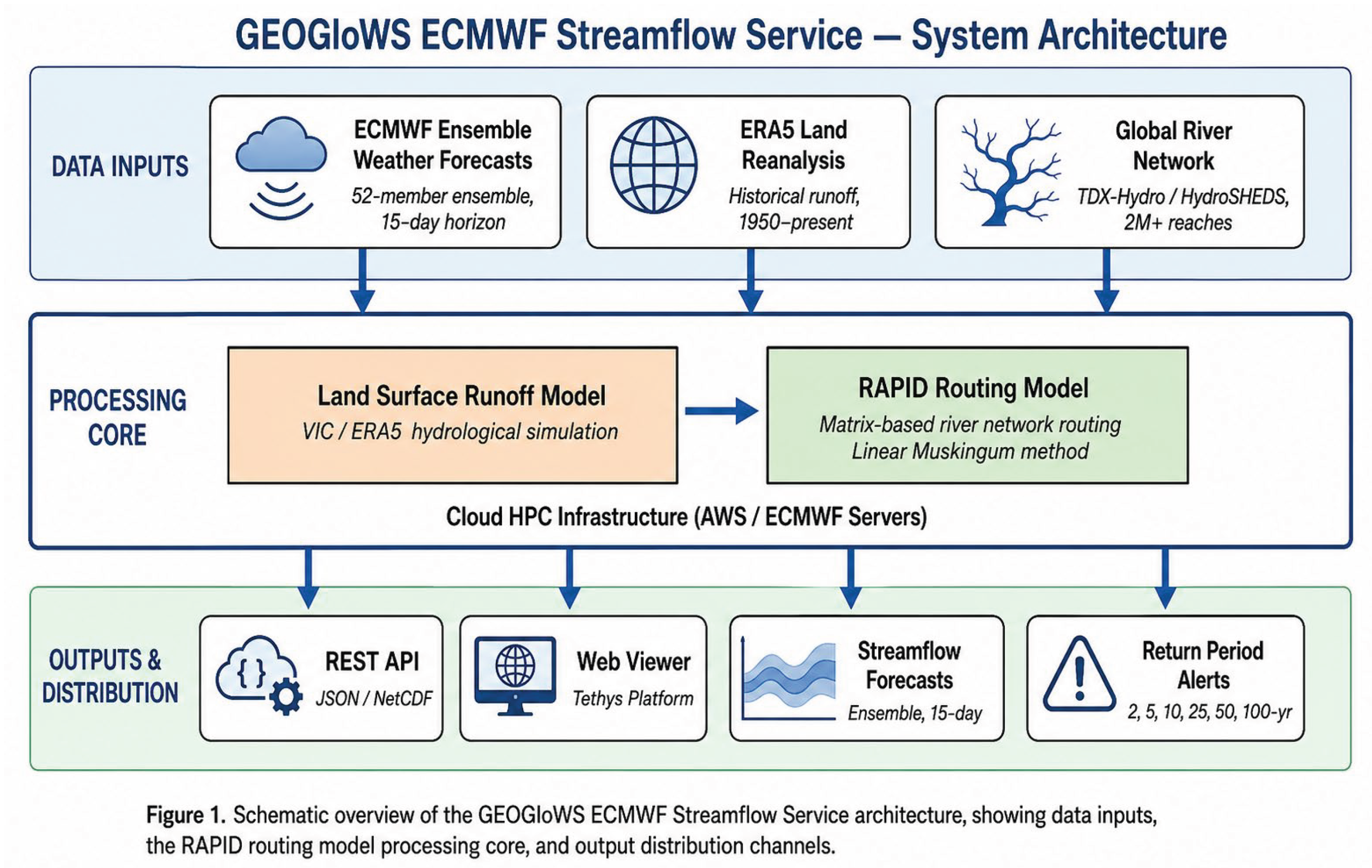
Figure 2.
The GEOGloWS Hydrology-as-a-Service (HaaS) workflow illustrating the connection between end-users (national hydromet services, local governments, NGOs) and cloud-hosted hydrological processing services, accessible through web browsers, REST APIs, and programming libraries without local model infrastructure.
Declaration of Generative AI and AI-Assisted Technologies in the Writing Process:
The authors would like to acknowledge the use of SciSpace for AI-assisted literature analysis and drafting support. The final manuscript has been thoroughly reviewed and approved by the human authors.
References
- Lozano, J.L.S.; Bustamante, G.R.; Hales, R.C.; Nelson, E.J.; Williams, G.P.; Ames, D.P.; Jones, N. A Streamflow Bias Correction and Performance Evaluation Web Application for GEOGloWS ECMWF Streamflow Services. Hydrology 2021, 8(2), 71. [Google Scholar] [CrossRef]
- Chancay, J.E.; Sánchez-Lozano, J.L.; Valencia, B.G. Enhancing GEOGLOWS River Forecast System with a High-Resolution Pre-Processing Approach for Runoff Bias Correction. Hydrology 2025, 13(5), 128. Available online: https://www.mdpi.com/2306-5338/13/5/128. [CrossRef]
- Hales, R.C. Sustainably Providing Accurate Local River Discharge Data with Global Hydrologic Modeling and Bias Corrections; ProQuest.
- Edwards, C.H. Forecasting Inundation Extents in the Amazon Basin Using SRH-2D and HAND Based on the GEOGloWS ECMWF Streamflow Services; ProQuest.
- Dahal, D.; Kojima, T. Evaluating the Performance of Hydrological Models for Flood Simulation in Wangchu River Basin, Bhutan; Preprints, 2025. [Google Scholar] [CrossRef]
- Lozano, J.L.S. Enhancing Local Hydrological Services with the GEOGloWS ECMWF Global Hydrologic Model; ProQuest.
- Huber, R. Hydrologic Decision Support in the Nile Basin: Creating Status and Outlook Products from the GEOGLOWS Hydrologic Model; ProQuest.
- Lozano, J.S.S.; Chancay, J.E.; Lesmes, D.J.R.; Bustamante, E.G.R.; Nelson, E.; Trujillo-Vela, M.G.; et al. Global Water Level Forecast System: Integrating EO Data for Hydrological Hazard Monitoring. 2025. [Google Scholar] [CrossRef]
- Ashby, K.R.; Hales, R.C.; Nelson, J.; Ames, D.P. Hydroviewer: A web application to localize global hydrologic forecasts. Open Water 7(1).
- Mbuvha, R.; Adounkpe, J.Y.P.; Houngnibo, M.; Mongwe, W.T.; Nikraftar, Z.; Marwala, T.; Newlands, N.K. A novel workflow for streamflow prediction in the presence of missing gauge observations. Environ. Data Sci. 2023, 2. [Google Scholar] [CrossRef]
- Mahjarin, T.; Huque, Z.T.; Akter, S.; Roy, P.; Ames, D.P. Introducing Flood Forecasting Framework Integrating GeoSWMM Hydrologic Simulation, GeoGLOWS Global Streamflow Model, and Machine Learning. SSRN 2025. [Google Scholar] [CrossRef]
- Hales, R.C.; Nelson, E.J.; Souffront, M.; Gutierrez, A.L.; Prudhomme, C.; Kopp, S.; Ames, D.P.; Williams, G.; Jones, N. Advancing global hydrologic modeling with the GEOGloWS ECMWF streamflow service. J. Flood Risk Manag. 2022. [Google Scholar] [CrossRef]
- Dahal, D. Evaluating the performance of various hydrological models for flood simulation in River Basins of Bhutan; Gifu University, 2025. [Google Scholar]
- Gutenson, J.; Sparrow, K.; Brown, S.; Wahl, M.; Gordon, K. Case study of continental-scale hydrologic modeling's ability to predict daily streamflow percentiles for regulatory application. 2024. [Google Scholar] [CrossRef]
- Magoffin, R.H.; Hales, R.C.; Nelson, E.J.; Wara, C.; Williams, G.P.; South, A.J.; Challa, Z.K. Hydrologic Decision Support in the Nile Basin: Creating Status Products from the GEOGLOWS Hydrologic Model. Hydrology 2025, 12(3), 43. [Google Scholar] [CrossRef]
- Lesmes, D.J.R.; Lozano, J.L.S.; Nelson, J.; Trujillo-Vela, M.G.; Williams, G.P.; Ames, D.P.; et al. Discharge-to-water level transformation (DWLT) using monthly duration curves: enhancing the utility of the GEOGLOWS ECMWF hydrological model. 2024. [Google Scholar] [CrossRef]
- Ames, D.P. When River Data Are Not Available: The Advent of High-Resolution, Large-Scale Hydrologic Models as a Proxy for Streamflow Observations. SSRN. Available online: https://papers.ssrn.com/sol3/papers.cfm?abstract_id=6560255.
- Hales, R.C.; Williams, G.; Nelson, E.J.; Sowby, R.B.; Ames, D.P.; Lozano, J.L.S. Bias Correcting Discharge Simulations from the GEOGloWS Global Hydrologic Model. J. Hydrol. 2023. [Google Scholar] [CrossRef]
- Lozano, J.L.S.; Lesmes, D.J.R.; Bustamante, E.G.R. Simulation performance evaluation and monthly flow duration curve quantile-mapping (MFDC-QM) of the GEOGLOWS ECMWF streamflow hydrologic model. In Environmental Modelling & Software; 2024. [Google Scholar] [CrossRef]
- Denissen, J.M.C.; Arduini, G.; Zsoter, E.; Mazzetti, C.; Prudhomme, C.; Harrigan, S.; et al. Towards a global km-scale flood forecasting system. In EGU General Assembly; 2024. [Google Scholar] [CrossRef]
- Emerton, R.; Zsoter, E.; Arnal, L.; Cloke, H.; Muraro, D.; Prudhomme, C.; Stephens, E.; Salamon, P.; Pappenberger, F. Developing a global operational seasonal hydro-meteorological forecasting system: GloFAS-Seasonal v1.0. Geosci. Model Dev. 2018, 11(8), 3327–3346. [Google Scholar] [CrossRef]
- Westoby, M.; et al. Rapid fluvial remobilization of sediments deposited by the 2021 Chamoli disaster, Indian Himalaya. Geology 2023. [Google Scholar] [CrossRef]
- Swain, N.R. Tethys Platform: A Development and Hosting Platform for Water Resources Web Apps; Brigham Young University, 2015. [Google Scholar]
- Nelson, E.J.; Pulla, S.T.; Matin, M.A.; Shakya, K.; Jones, N.; Ames, D.P.; Ellenburg, W.L.; Markert, K.; David, C.H. Enabling Stakeholder Decision-Making With Earth Observation and Modeling Data Using Tethys Platform. Front. Environ. Sci. 2019, 7. [Google Scholar] [CrossRef]
- Snow, A.D. A New Global Forecasting Model to Produce High-Resolution Stream Forecasts; Brigham Young University, 2015. [Google Scholar]
- Comparative analysis of GEOGloWS and PM tank models for river flow forecasting in data-sparse regions. Figshare 2025. [CrossRef]
- Alfieri, L.; Burek, P.; Dutra, E.; Krzeminski, B.; Muraro, D.; Thielen, J.; Pappenberger, F. GloFAS - global ensemble streamflow forecasting and flood early warning. Hydrol. Earth Syst. Sci. 2013, 17(3), 1161–1175. [Google Scholar] [CrossRef]
- Peters-Lidard, C.D.; Hossain, F.; McDowell, N.G.; Rodell, M.; Tapiador, F.J.; Turk, F.J.; Wood, A.W. Chapter 14: 100 Years of Progress in Hydrology; AMS Meteorological Monographs, 2019. [Google Scholar]
- Pagano, T.C.; Wood, A.W.; Ramos, M.H.; Cloke, H.; Pappenberger, F.; Clark, M.P.; et al. Challenges of operational river forecasting. J. Hydrometeorol. 2014, 15(4), 1692–1707. [Google Scholar] [CrossRef]
- Towner, J.; Cloke, H.; Zsoter, E.; Flamig, Z.L.; Hoch, J.M.; Bazo, J.; Perez, E.C.; Stephens, E. Assessing the performance of global hydrological models for capturing peak river flows in the Amazon basin. Hydrol. Earth Syst. Sci. 2019, 23(7), 3057–3080. [Google Scholar] [CrossRef]
- Peters-Lidard, C.D.; Hossain, F.; Leung, L.R.; McDowell, N.G.; Rodell, M.; Tapiador, F.J.; Turk, F.J.; Wood, A.W. 100 Years of Progress in Hydrology. Meteorol. Monogr. 2018, 59(1). [Google Scholar] [CrossRef]
- Chancay, J.E.; Sanchez-Lozano, J.; Dawson, K.L. From Data Streams to Decisions: Multi-Source Hydrometeorological Integration Platforms for Interagency Risk-Management Capacity Building in Data-Limited Regions; IntechOpen.
- Carey, L.; Anderson, E. Earth observations to mitigate flood impacts in Central America: translating research to decision-making and actions. In Natural Hazards and Earth System Sciences; 2026. [Google Scholar] [CrossRef]
- Whitney, K.M.; Peters, R.M.; Mishra, A.; Blum, A.G. Integrating science for water security governance. In Global Environmental Change; 2026. [Google Scholar] [CrossRef]
- Deval, C.; Anderson, E.; Kruskopf, M.; Limaye, A.; Bhandari, B.; Markert, A.; et al. Connecting science to sustained impact: SERVIR's journey in earth observations for water resources management and future pathways. 2024. [Google Scholar] [CrossRef]
- Asherman, J.; Bates, B.; Flynn, W.; Erickson, M.; Lamers, A. Anticipating 'The Big One': Developing decision support with emergency managers to mitigate flood impacts. 2022. [Google Scholar] [CrossRef]
- Hoedjes, J.C.B.; Kooiman, A.; Maathuis, B.H.P.; Said, M.Y.; Betch, R.; Limo, A.; Mumo, M.; Mathenge, J.N.; Shaka, A.; Su, B. Int. J. Geo-Inf. 2014. [CrossRef]
- Madsen, M.D.; Payet-Burin, R.; Butts, M.; Dhaubanjar, S.; Pedersen, J.W.; Martinsen, G.; et al. Rapid development of impact-based national flood early warning system. In EGU General Assembly; 2025. [Google Scholar] [CrossRef]
- Hoedjes, J.C.B.; Kooiman, A.; Maathuis, B.H.P.; Said, M.Y.; Becht, R.; Limo, A.; Mumo, M.; Nduhiu-Mathenge, J.; Shaka, A.; Su, B. A Conceptual Flash Flood Early Warning System for Africa, Based on Terrestrial Microwave Links and Flash Flood Guidance. ISPRS Int. J. Geo-Inf. 2014, 3(2), 584–598. [Google Scholar] [CrossRef]
- Jubach, R.; Tokar, A.S. International Severe Weather and Flash Flood Hazard Early Warning Systems. Water 2016, 8(6), 258. [Google Scholar] [CrossRef]
- Arnal, L.; Anspoks, L.; Manson, S.; Neumann, J.L.; Norton, T.; Stephens, E.; Wolfenden, L.; Cloke, H. 'Are we talking just a bit of water out of bank? Or is it Armageddon? Geosci. Commun. 2020, 3(2), 203–232. [Google Scholar] [CrossRef]
- Lozano, J.L.S. Enhancing Local Hydrological Services with the GEOGloWS ECMWF Global Hydrologic Model; ProQuest.
- Leb, C. Data Innovations for Transboundary Freshwater Resources Management: Are Obligations Related to Information Exchange Still Needed? 2020. [Google Scholar] [CrossRef]
- FEWS- Uruguay: Aplatform for Flood Early Warning System water management (2022). I.A.H.S. [CrossRef]
- Hirpa, F.A.; Pappenberger, F.; Arnal, L.; Baugh, C.; Cloke, H.; Dutra, E.; Emerton, R. Global Flood Forecasting for Averting Disasters Worldwide. In Handbook of Hydrometeorological Ensemble Forecasting; 2018; pp. 205–228. [Google Scholar] [CrossRef]
- Tsering, K.; Shakya, K.; Matin, M.A.; Nelson, J.; Bajracharya, B. Enhancing Flood Early Warning System in the HKH Region. In Himalayan Weather and Climate; 2021; pp. 169–200. [Google Scholar] [CrossRef]
- Tsering, K.; Shrestha, M.; Shakya, K.; Bajracharya, B.; Matin, M.A.; Lozano, J.L.S.; Nelson, J.; Wangchuk, T.; Parajuli, B.; Bhuyan, A. Verification of two hydrological models for real-time flood forecasting in the Hindu Kush Himalaya (HKH) region. Nat. Hazards 2021, 1–25. [Google Scholar] [CrossRef]
- Rodriguez, A.; Llort, X.; Sancho, D.; Sanchez-Diezma, R.; Bella, R.; Gomez, V. Hidromet: A Cloud-Based EWS Platform For Real Time Urban Flood Warning. 2014. [Google Scholar]
- Vieux, B.E.; Vieux, J.E. Keeping everyone on the same page during flash flood emergencies. WIT Trans. Built Environ. 2020, 194, 51–61. [Google Scholar] [CrossRef]
- Alfieri, L.; Bucherie, A.; Libertino, A.; Campo, L.; D'Andrea, M.; Ghizzoni, T.; Gabellani, S.; Massabo, M.; Rossi, L.; Rudari, R.; Sisouphanthavong, B. Impact-based flood early warning in Lao PDR and Cambodia. In EGU General Assembly; 2025. [Google Scholar] [CrossRef]
- Dasgupta, A.; Arnal, L.; Emerton, R.; Harrigan, S.; Matthews, G.; Muhammad, A.; O'Regan, K.L.; Perez-Ciria, T.; Valdez, E.; van Osnabrugge, B.; Werner, M. Connecting hydrological modelling and forecasting from global to local scales. J. Flood Risk Manag. 2023. [Google Scholar] [CrossRef]
- Zsoter, E.; Salamon, P.; Prudhomme, C. Providing transboundary flood forecasts with the Global Flood Awareness System (GloFAS); IUGG, 2023. [Google Scholar] [CrossRef]
- Alcantara, S.; Antonio, M. A Flexible Service-Oriented Approach to Address Hydroinformatic Challenges in Large-Scale Hydrologic Predictions; 2018. [Google Scholar]
Disclaimer/Publisher’s Note: The statements, opinions and data contained in all publications are solely those of the individual author(s) and contributor(s) and not of MDPI and/or the editor(s). MDPI and/or the editor(s) disclaim responsibility for any injury to people or property resulting from any ideas, methods, instructions or products referred to in the content. |
© 2026 by the authors. Licensee MDPI, Basel, Switzerland. This article is an open access article distributed under the terms and conditions of the Creative Commons Attribution (CC BY) license (http://creativecommons.org/licenses/by/4.0/).
Copyright: This open access article is published under a Creative Commons CC BY 4.0 license, which permit the free download, distribution, and reuse, provided that the author and preprint are cited in any reuse.